Article

Study on Spatio-Temporal Pattern Changes and Prediction of Arable Land Abandonment in Developed Area: Take Pingyang County as an Example

1
College of Economics & Management, Anhui Agricultural University, Hefei 230036, China
2
College of Big Data, Qingdao University of Science and Technology, Qingdao 266061, China
3
Institute of Agriculture Remote Sensing and Information Technology, College of Environmental and Resource Sciences, Zhejiang University, Hangzhou 310058, China
*
Author to whom correspondence should be addressed.
Sustainability 2022, 14(17), 10560; https://doi.org/10.3390/su141710560
Submission received: 1 August 2022 / Revised: 19 August 2022 / Accepted: 20 August 2022 / Published: 24 August 2022
(This article belongs to the Section Resources and Sustainable Utilization)

Abstract

:
The problem of arable land abandonment has become increasingly prominent in China as an important hidden danger of regional and national grain security. Therefore, it is necessary to fully understand its developmental mechanism in order to improve land protection policies and maintain the sustainable use of arable land. This study took Pingyang County in the Yangtze River Delta Economic Zone as an example. Based on remote sensing image data in 2000, 2010, and 2018, the landscape pattern index was used to reveal the changes in the landscape pattern of abandoned land in the study area, and the FLUS model was used to simulate the spatial and temporal distribution changes in abandoned land in the study area in 2028. The results showed that the abandoned areas in the study area spread rapidly from 2000 to 2018, the area of abandoned land increased nearly 12 times in the past 18 years, and the areas with a high abandonment rate were concentrated in the western and northwestern mountainous areas of the study area. In the view of the landscape pattern, the areas with a high fragmentation degree of abandoned land gradually shifted to the western mountainous areas from 2000 to 2018, and the areas with high landscape complexity of abandoned land gradually shifted from the middle to the northern and western areas. The simulation results of abandoned land showed that the high-value areas of abandoned land rate in the study area would be more concentrated by 2028. Among them, the abandoned land rate of arable land in the northwest would increase to 15.76~24.89%, while the landscape fragmentation and complexity of abandoned land would be slightly lower than that in 2018. Finally, some countermeasures were proposed for the protection and sustainable utilization of cultivated land resources.

1. Introduction

The abandonment of arable land is one of the main manifestations of rural decline all over the world [1,2,3,4] which has attracted the extensive attention of many scholars. Some scholars focused on the analysis of the current situation of abandoned land, explored the distribution differences of abandoned land in different income countries and regions [5], and revealed the development status of different types of arable land in the same country. For example, in Europe, the United States, Australia, Japan, and China [6], most of the arable land is abandoned mainly in mountainous areas [7]. These areas are prone to arable land abandonment due to large topographic fluctuation, high altitude, and large slope [8,9]. Some scholars also paid attention to the causes and influencing factors of abandonment. They believed that economic factors such as the outflow of rural population [10], the reduction in the number of professional farmers [11], farmers’ indifference to local feelings [12], the imbalance of farming costs and benefits, as well as natural factors such as complex terrain or distance accessibility have caused the abandonment of arable land [13,14]. In addition, some scholars have carried out research on the social and environmental problems that may be brought about by large-scale continuous land abandonment, including the vicious cycle between rural hollowing and arable land abandonment [15], forest fires caused by the accumulation of vegetation and fuel in abandoned arable land [16], and the reduction in the stress resistance of abandoned arable land exacerbating the degree of vegetation destruction and the contradiction between human and land. These studies found that the abandonment of arable land easily unbalances ecological environment [17] and causes huge food loss and the loss of economic value [18].
Arable land is an important resource for human survival. The protection of arable land resources is closely related to national food security and social stability [19,20]. It is particularly important for China, a large agricultural country with more people and less land. However, in recent years, with the development of industrialization and urbanization, the problems of arable land abandonment, non-grain production, and non-agriculturalization have become increasingly prominent, which has posed a serious threat to the scale and quality of arable land [11,21,22,23]. Li et al. [24] found that in 2017, the area of abandoned arable land in China reached about 9.13 million hm2, and the abandonement rate was 6.75%. The phenomenon of arable land abandonment exists in 95% of counties in China. With the increasing downward pressure on the domestic economy and the complexity of the international situation, if the trend of arable land abandonment is not effectively curbed, it will seriously threaten national food security and political stability. Therefore, to solve the problem of protecting arable land, it is important to deeply understand the law of spatial and temporal evolution of the abandonment phenomenon, identify high-risk areas, and take corresponding preventive measures.
At present, the identification and analysis of abandoned farmland are mostly based on field investigation and remote sensing monitoring. The rapid development of remote sensing technology makes it possible to accurately monitor the spatial and temporal dynamic changes in arable land abandonment with high precision and a long-time sequence. Few studies have revealed the spatial and temporal evolution law of arable land abandonment on the land patch scale and predicted the expansion trend of arable land abandonment. At the same time, the impact of abandoned land on the evolution of arable land landscape structure and spatial allocation characteristics is not clear. Taking Pingyang County in Zhejiang Province, which has a developed economy and prominent human and land contradiction, as an example, this study revealed the spatial and temporal dynamic change law and landscape pattern change characteristics of arable land abandonment, explored the expansion mechanism of arable land abandonment, and predicted and identified the high-risk areas of arable land abandonment in Pingyang County in the future. The specific objectives of this paper were as follows: (1) based on remote sensing and GIS technology, the spatial and temporal dynamic changes in abandoned arable land in Pingyang County were quantitatively analyzed; (2) the dynamic change in the landscape pattern of abandoned arable land was revealed through the landscape pattern index; (3) the utilization of arable land in 2028 was predicted by the FLUS model to identify the high-risk areas of abandonment; (4) the relevant countermeasures and suggestions for arable land resource protection were proposed. The research results of this paper could provide a scientific basis for the formulation and improvement of arable land protection policies in Pingyang County. This study has reference value for the management of arable land abandonment in other areas and is of great significance to effectively maintain national food security.

2. Datasets and Methods

2.1. Study Area

This study selects Pingyang County, a typically developed county in the south of China’s Yangtze River Delta Economic Zone, as the study area. It is a subordinate county of Wenzhou City in the southeast region of Zhejiang Province. Pingyang County faces land on three sides and sea on one side. The eastern part of the county is located at the boundary of the East China Sea. The land area of the county is about 1051 km2. It is located at 27°21′–27°46′ N and 120°24′–121°08′ E (Figure 1). It belongs to a tropical marine monsoon climate area. The regional terrain presents the distribution law of high in the west and low in the east. The terrain in the southeast of the county is flat and rich in arable land resources. The planting industry in the study area has a long history and the grain output ranks first around Zhejiang Province. Therefore, it is known as “Pingyang million granary”. The agricultural planting structure is mainly grain crops, vegetables, tea, and other cash crops.

2.2. Data Source and Processing

Combined with China’s current land management laws, policies, and regulations, this study defined abandoned arable land as arable land that has not been cultivated in the farming season and has been completely exposed or grown weeds under the influence of many factors such as physical geography, social policies, and system. It includes seasonal abandoned arable land and fallow land. To obtain accurate data on abandoned arable land, this study comprehensively used the three phases of Landsat TM remote sensing images (spatial resolution was 30 m) in the farming season (from May to September) of 2000, 2010, and 2018 (https://www.gscloud.cn/, accessed on 27 May 2018), 1:10,000 land-use change survey data of the Pingyang County Bureau of Land and Resources, Google Earth satellite images (spatial resolution was 0.13 m), and multi-temporal aerial images (spatial resolution was 1 m) to obtain the abandoned arable land map information on the scale of land patch.

2.3. Methodology

2.3.1. Landscape Pattern Index

The landscape pattern index is an important quantitative index in landscape pattern research that can reflect the composition of landscape structure and spatial allocation characteristics. To reveal the dynamic change process and spatio-temporal law of the landscape pattern of abandoned arable land, this study selected patch density (PD), largest patch index (LPI), average patch area (MPS), and landscape shape index (LSI) to quantitatively evaluate the landscape fragmentation and complexity of abandoned arable land in the county. In this study, Fragstats 4.2 software was used to calculate the landscape pattern index of abandoned arable land in the study area from 2000 to 2018, and Kriging interpolation was carried out for each grid landscape index in ArcGIS 10.3 software to analyze the spatial change in the landscape index of abandoned arable land in the county.

2.3.2. FLUS Model

FLUS (Future Land Use Simulation) is a model for simulating land use that can predict the future land use by inputting human activities or natural geographical factors affecting land use [25]. Based on the optimized Cellular Automata (CA), the FLUS model makes a series of systematic calculations on the initial land use and various influencing factors by using the artificial neural network model algorithm (ANN) and obtains the suitability probability of land use types in the study area. Then, the competition mechanism is introduced. The suitability probability obtained by the ANN algorithm is combined with the neighborhood factor data and conversion cost data obtained from the evaluation of the situation of the study area. The overall conversion probability and number of excavated land use cells are calculated systematically, the optimized related parameters are adjusted, and the land use map of the predicted year is obtained through the competition mechanism [26]. The framework of the model is mainly composed of the following two parts: the artificial neural network suitability probability calculation and the adaptive inertial competition mechanism [27].
The construction process of the FLUS model for the prediction of the abandoned arable land trend in this study refers to the existing literature of relevant researchers [28,29,30], and will be not be repeated here. Combined with the characteristics of abandoned arable land transformation in Pingyang County from 2000 to 2018, the parameters of the neighborhood factor of land use type were finally determined after multiple preset simulations, specifically, the abandoned arable land transformation parameter was 0.8 and the non-transformation parameter was 0.3. The simulation map of the abandoned arable land distribution in Pingyang County in 2018 was output. The calculation results of the overall accuracy and Kappa coefficient showed that the values were close to “1”, which indicated that the simulation accuracy is good [31]. Finally, based on the current situation map of abandoned arable land in Pingyang County in 2018, the suitability probability was calculated again, and the neural network training was carried out to obtain the prediction map of the arable land abandonment trend in Pingyang County in 2028.

3. Results

3.1. Remote Sensing Monitoring and Spatio-Temporal Distribution Changes in Abandoned Arable Land

According to the remote sensing extraction results of abandoned arable land patches in Pingyang County in 2000, 2010, and 2018 (Figure 2), it could be observed that, spatially, from 2000 to 2018, the distribution of abandoned arable land in the study area showed a trend of increasing year by year. Among them, the abandoned arable land was sparsely distributed in 2000. In 2010, it was generally spread in the western mountainous towns. However, by 2018, except for the eastern coastal plain area, other hilly areas in the study area had abandoned arable land to varying degrees. Among them, the abandoned arable land in western mountainous areas continued to expand.
From the view of the abandoned area (Table 1), the overall abandoned arable land area was 441.58 hm2 in 2000, and the abandoned arable land rate was only 0.42%. By 2018, the area of the abandoned arable land in Pingyang County increased to 5797.40 hm2, and the abandoned arable land rate reached 5.46%. The area of abandoned arable land increased nearly 12 times in eighteen years.
From a subregional perspective, the abandoned arable land in 2000 was mainly distributed in villages and towns around mountains and hills. In the decade from 2000 to 2010, the farming disadvantages of villages and towns around mountains gradually appeared and the abandoned area increased. The area of abandoned arable land in the towns of Nanyan, Huaixi, and Shunxi, which are located in Nanyandang Mountain, increased by about 300 hm2. The area of abandoned arable land in the towns of Aojiang and Tengjiao remained high, and the phenomenon of arable land abandonment in these towns was still serious. The terrain of these areas was complex. Most of the arable land had high altitude, large slope, scattered patch, and a low degree of farming mechanization, which led to the imbalance of farming costs and benefits for farmers and was very prone to arable land abandonment.
From the spatio-temporal changes in abandoned arable land rate in the study area from 2000 to 2018 (Figure 3), the regional distribution with the abandonment rate of more than 1.60% in 2000 was relatively scattered, which was mainly distributed in the transition zone between mountainous areas and plains in the northwest and southwest and near the town of Wanquan in the northeast of the study area. Except for the above areas, the abandonment rate in other areas was low and less than 0.41% (Figure 3a). In 2010, the areas with a high abandonment rate in the study area expanded rapidly. Among them, the abandonment rates in four regions, such as the towns of Fengwo, Shanmen, and Huaixi in the northwest and some regions of the towns of Wanquan, Kunyang, and Aojiang in the northeast, were higher than 4.53%. Compared with that in 2000, the distribution of regions with a high abandonment rate in 2010 had high spatial aggregation. In 2018, the areas with an abandonment rate of more than 4.05% accounted for about 3/5 of the total area of the study area and were mainly distributed in the west of the town of Aojiang, of which the areas with an abandonment rate of 9.82~12.70% were mainly concentrated in four towns in the north.

3.2. Landscape Pattern Changes in Abandoned Arable Land

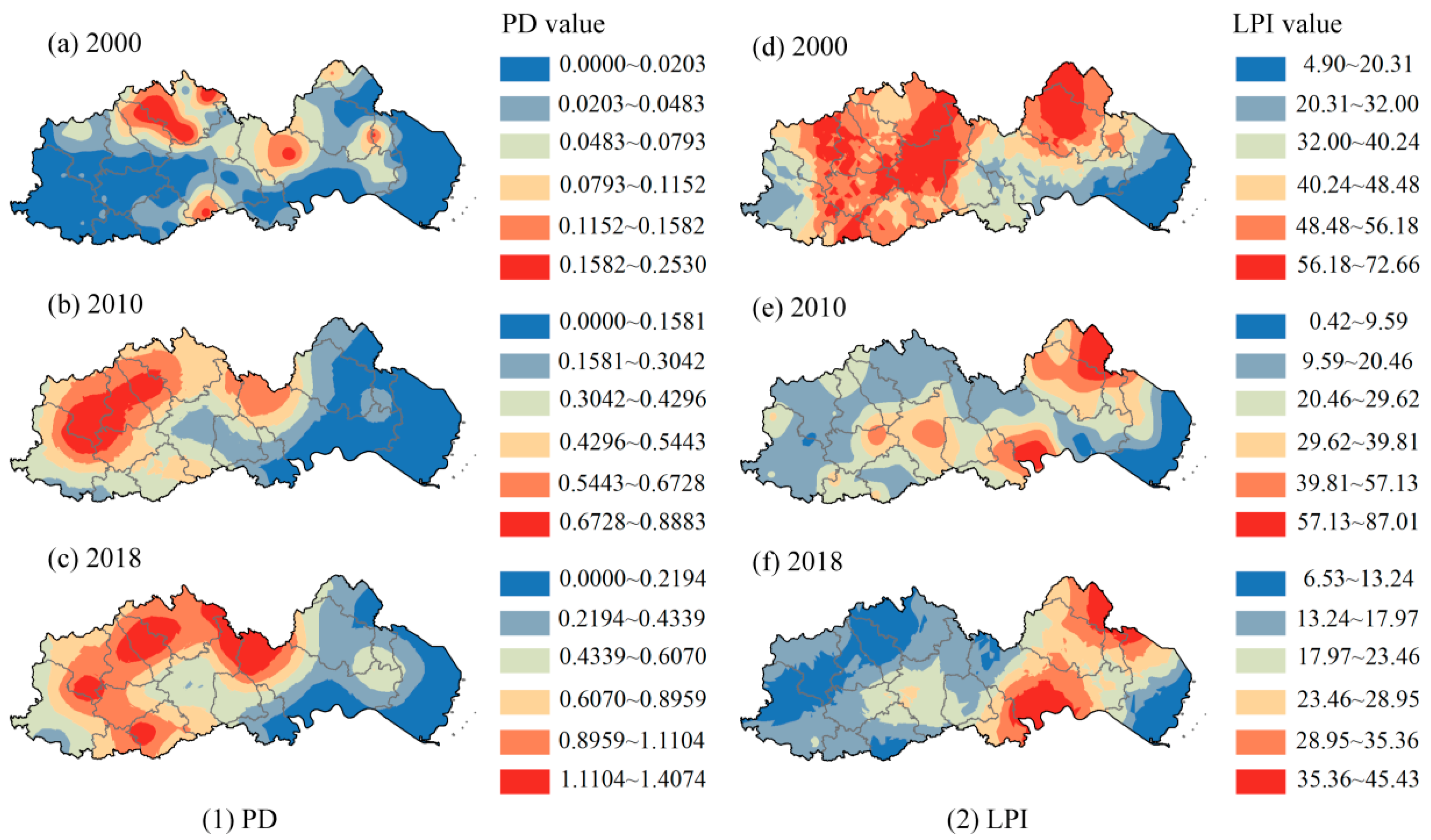
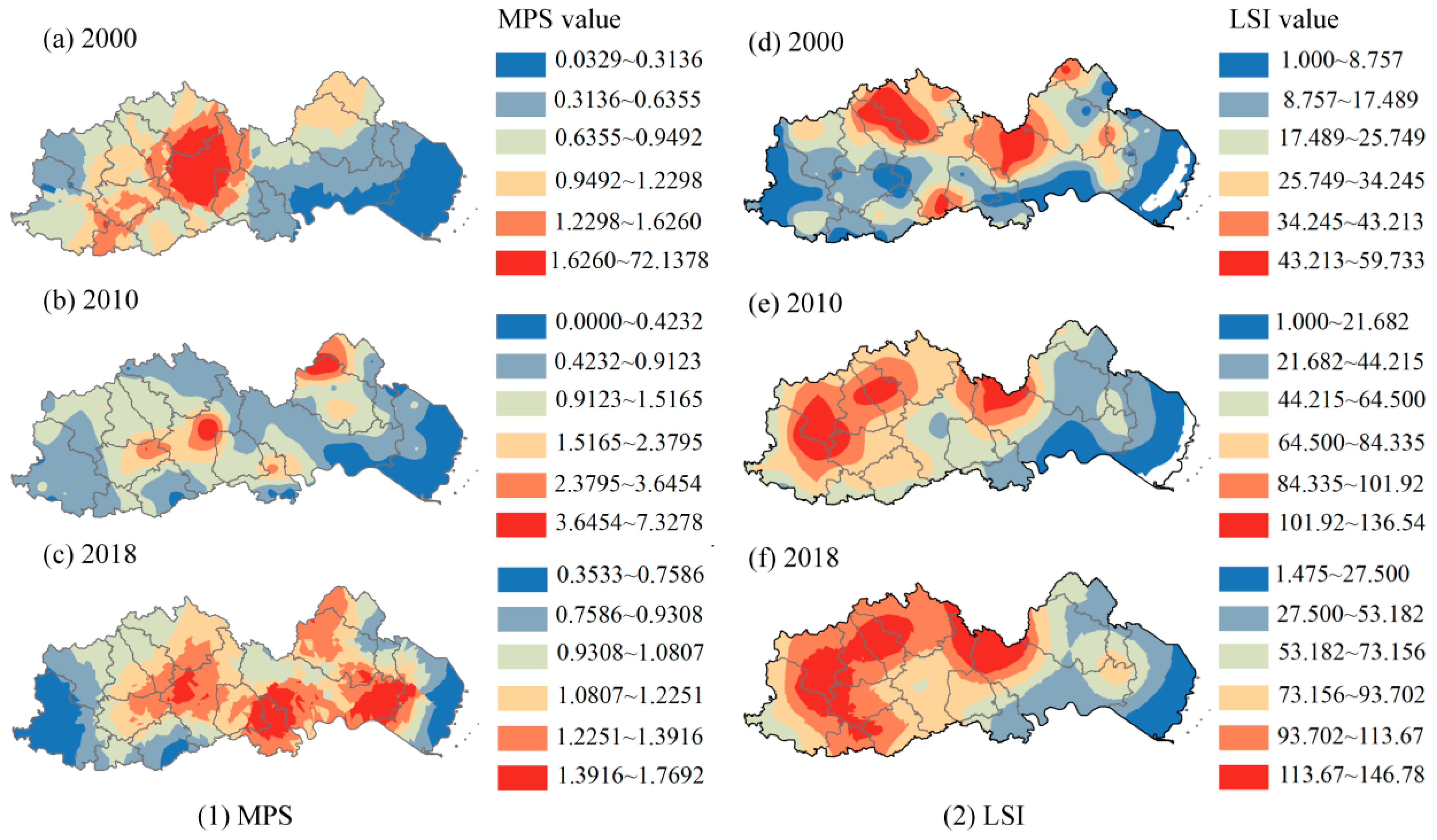
To further explore the landscape pattern changes in abandoned arable land in the study area from 2000 to 2018, PD, LPI, and MPS indexes were selected to quantify the fragmentation degree of abandoned areas, and the LSI index was selected to quantify the landscape complexity of abandoned areas. Overall, the PD index of abandoned arable land in the study area increased from 0.0038 in 2000 to 0.6013 in 2018, and the LPI index decreased from 3.2051 in 2000 to 0.4649 in 2018, which indicated that the patches of abandoned arable land in the study area showed a fragmentation trend from 2000 to 2018 (Table 2). From 2000 to 2010, the MPS value in the study area decreased, while in 2018, the MPS value increased from 0.8808 to 0.9251, which indicated that while the abandoned arable land in the study area experienced the trend of patch fragmentation, the average patch area of the abandoned arable land had rebounded, and the abandonment of large arable land patches gradually appeared. The LSI index of abandoned arable land from 2000 to 2018 in the study area increased from 27.5642 to 109.4218, which showed that the patch shape of abandoned land tended to be complex, and the abandonment behavior gradually developed to irregular fields.
To evaluate the differences in spatio-temporal patterns of the landscape fragmentation and complexity of abandoned arable land, this study used the Ordinary Kriging method in the spatial analysis tool to analyze the spatio-temporal changes in four indexes (Figure 4). The spatial interpolation results showed that the high-value areas of the PD index in 2000 were relatively scattered and mainly distributed in the northwest and northern towns, while the high-value areas of the PD index expanded rapidly in 2010 and 2018 and were mainly distributed in large areas in the west of the study area (Figure 4a–c). In the view of spatio-temporal changes in the LPI index (Figure 4d–f), the low value areas of the LPI index gradually shifted to the west from 2000 to 2018, and the LPI index in western mountainous areas was generally low by 2018. Combined with the spatio-temporal changes in the PD index, it could be observed that the fragmentation trend of abandoned arable land in the western mountainous towns’ areas of the study area was obvious, and the change in land form caused by land abandonment had a certain negative impact on regional water and soil conservation.
From 2000 to 2018, the high-value area of the MPS index experienced first shrinking and then gradually spreading from the central region to the west and east, which showed the spatio-temporal changes in the distribution of large abandoned land (Figure 5a–c). By 2018, the abandoned arable land with large patch area was mainly concentrated in hills, plains, and coastal areas such as the towns of Shuitou, Xiaojiang, and Aojiang. The analysis results of spatio-temporal changes in the LSI index showed that the areas with high landscape complexity of abandoned land gradually shifted from the center and north in 2000 to the west (Figure 5d–f), and the landscape complexity of abandoned land in the central and western part of the study area was high by 2018, which showed that with the increase in the abandonment rate and the fragmentation of abandoned land patches in these areas, the shape of the abandoned land tended to be complex. This posed a challenge to the management and the re-tillage and replanting of abandoned arable land in the future.

3.3. Trend Prediction of Abandoned Arable Land

3.3.1. Model Performance Analysis

This study compared the simulation results of abandoned land by using the FLUS model with the actual abandoned land situation in 2018. Overall, the simulation map highly coincided with the actual abandoned land map in 2018 (Figure 6a,b), which showed that the reliability of the prediction results was high. The accuracy evaluation results showed that the overall accuracy of this verification was 0.875 and the Kappa coefficient was 0.71, which indicated that the overall simulation accuracy was high and the applicability of the FLUS model in this study was good.
However, although the roulette mechanism of the FLUS model increased flexibility, it also brought uncertainty about land use change. There was a development illusion that a cell expands into a region, which would produce a certain degree of error when the total amount of simulation remained unchanged. By comparing some areas (Figure 6c–f), it was found that the simulated abandonment results in some areas were different from the actual situation to some extent. This was related to the reason that the FLUS model followed the proximity diffusion effect in the simulation, resulting in the radial expansion of cells. However, in the actual abandoned land, the proximity effect was not obvious due to the influence of various artificial and unpredictable factors. Therefore, the simulation results did not coincide with the current situation of abandoned land in some areas. However, this study focused on the trend of abandoned arable land in the county. Although there were differences in local simulation results, it did not affect the analysis of the overall trend of abandoned arable land in the county.

3.3.2. Simulation of Abandoned Arable Land Trend in 2028

Based on the current situation map of abandoned arable land in the study area in 2018, the trend prediction map of abandoned arable land in the study area in 2028 was obtained using the FLUS model (Figure 7). From the simulation prediction results, in the absence of human intervention, the area of abandoned land in the study area would continue to increase in 2028, and the area increased from 5797.40 hm2 in 2018 to 7138.80 hm2 in 2028, with an increase of 23.14% over the decade. At the same time, the overall abandonment rate in the study area also increased from 5.46% in 2018 to 6.93% in 2028. Compared with the change in the abandonment rate from 2000 to 2018, it could be observed that the abandonment rate of arable land in the study area increased slowly from 2018 to 2028, and the trend of the large amount of abandonment of arable land had been curbed to a certain extent. The spatial interpolation results of the abandoned arable land rate in 2028 showed that compared with 2018, the areas of high-value of abandoned arable land rate in the study area in 2028 would be more concentrated, in which the abandoned arable land rate in the northwest increased from 9.82% ~ 12.70% to 15.76% ~ 24.89% in 2028. The change in abandoned arable land rate in other areas was relatively gentle, and the overall evolution law was consistent with that in 2018.
According to the superposition analysis of abandoned areas between 2028 and 2018 (Figure 8), the increased abandoned areas in 2028 would be mainly distributed in the north of Tengjiao, Shuitou, Aojiang, and other towns in the study area, as well as the coastal hilly area in the east. These areas were located in the transition area from the mountainous area to the plain, low mountain and hilly area, and the landform changed greatly. It was difficult to cultivate, thus, these areas would become the main occurrence areas of abandoned land in the future.

4. Discussion and Conclusions

4.1. Spatio-Temporal Pattern Differences of Abandoned Arable Land in a County of Economically Developed Areas

As the sixth largest urban agglomeration in the world, the Yangtze River Delta Economic Zone has developed rapidly. Thanks to China’s excellent regulation and control in the field of macroeconomic policies, the region still maintains a high driving force of economic growth. However, with the rapid development of the economy and the rapid improvement of the urbanization rate, the contradiction among population, resources, and environment has become increasingly prominent; especially with the job demands brought by the rapid development of secondary and tertiary industries, a large number of rural residents gave up farming, resulting in the phenomenon of arable abandonment [32,33]. By comparing the spatio-temporal changes in arable abandonment rate in the county of the Yangtze River Delta Economic Zone from 2000 to 2018 (Figure 3), we found that while the overall abandonment rate in the study area increased year by year, some areas with a high abandonment rate showed a trend of rapid outward spread and expansion. In particular, the west of the study area was the main concentration area with high abandonment rates. This study quantitatively evaluated the spatio-temporal pattern changes in abandoned arable land in a county of economically developed areas through geographic information technology, and revealed the local characteristics of the regional arable abandonment phenomenon. Previous studies paid more attention to the behavior, causes, and current situation analysis of arable abandonment [34,35,36], which struggled to reveal the local differences of arable abandonment from the perspective of spatial and temporal dynamics, especially the heterogeneity of the regional ecological environment, geographical elements, economy, population, and resource endowment, resulting in strong local characteristics of arable abandonment in a spatio-temporal pattern. This study analyzed the spatio-temporal changes in the landscape index of abandoned arable land in the county from 2000 to 2018 (Figure 4 and Figure 5). The results showed that there were great differences in the fragmentation and complexity of abandoned arable land landscape in different places and years in the study area. The fragmentation and complexity of abandoned land patches in the region near the transition from mountainous area to plain in the west were generally high, which was mainly related to the topographic and geomorphic characteristics of the region. Due to the large topographic relief, less arable land resources and great difficulty in farming in the transition zone from mountainous area to coastal plain, it was difficult to form large-scale mechanical farming. Under the joint action of high labor cost, high field management cost, and the difficulty and improved employment treatment of enterprises, the number of abandoned land in these areas continued to increase. In the absence of field management, the fragmentation of abandoned arable patches increased and the landscape shape tended to be complex.
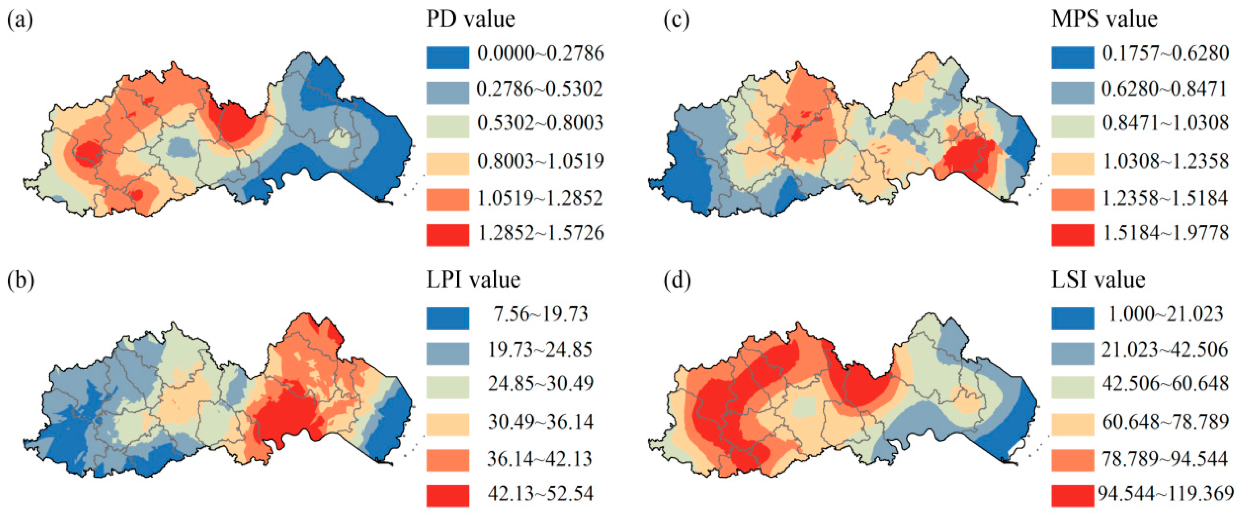
In this study, the FLUS model was used to simulate the arable abandonment in a county of economically developed areas in 2028. Through the calculation of landscape index, it was found that the degree of fragmentation and the complexity of landscape shape of abandoned land patches in the study area decreased slightly in 2028 compared with 2018 (Table 3). From the view of spatio-temporal changes in the landscape pattern (Figure 9), the range of high-value and low-value areas of landscape index in each region changed slightly in 2028. The fragmentation and complexity of abandoned land patches were consistent with the distribution trend in 2018, and the landscape pattern of abandoned land in some regions was optimized to a certain extent. The reasons were mainly related to the following two points: On the one hand, because the simulation mechanism of the FLUS model followed the adjacent diffusion effect, the cell diffusion was radial, and the local characteristics were the improvement of the aggregation degree of patches [27,37]. In the absence of human behavior intervention, the simulation results of abandoned land showed a central outward expansion trend, which reduced the fragmentation of regional abandoned land patches. On the other hand, by 2028, the Yangtze River Delta Economic Zone will enter a high-quality development stage, and the extensive economic development will gradually change into development driven by scientific and technological innovation. The integration process of the Yangtze River Delta Economics Zone will promote the balance of regional resource endowments and the narrowing of the gap between urban and rural areas. The counter feeding effect of secondary and tertiary industries on agriculture will gradually appear, which will be conducive to the circulation of arable land in rural areas and the expansion of large-scale planting [38,39]. The rehabilitation of abandoned land and the development of agricultural industrialization will help to reduce the landscape fragmentation of abandoned land.

4.2. Driving Mechanism of Abandoned Arable Land in a County of Economically Developed Areas

With the continuous expansion of the global population base, food security has become the focus of all countries, especially developing countries, when formulating national development strategies [40]. As the world’s most populous country, China’s total economic output also ranks among the top in the world. Population aging, high-quality economic development, and food security have become the main hidden dangers affecting the sustainable development of the country’s economy and society [41]. However, the guarantee of food security is inseparable from the protection of arable land resources. This study focuses on China’s Yangtze River Delta Economic Zone with the most active global economic activities. At the same time, this region is also the most developed region of county economy in China. Therefore, the contradiction between land demand and arable land resource protection in economic development is very acute [42]. By analyzing the history, current situation, and future spatio-temporal pattern of typical abandonment areas, this study attempted to reveal the trend of arable land abandonment, explore the driving mechanism of arable land abandonment, and provide data support for the protection of arable land resources in economically developed areas.
Through spatial interpolation analysis, this study obtained the spatio-temporal changes in the landscape pattern of abandoned land in the county from 2000 to 2028. The results showed that the arable land abandonment rate in the western mountainous areas and the transition area to the plain was high, and the landscape of abandoned land was fragmented and complex. From the view of natural resource endowment, the limitation of natural conditions was the main driving factor leading to the continuous spread of arable land abandonment in these areas. However, from the view of macroeconomic and social development, population and economic development were the deep-seated reasons driving the continuous occurrence of arable land abandonment [43,44]. As we all know, economic development will inevitably promote the improvement of the population education level, income level, and the change in employment type [45]. The Yangtze River Delta Economic Zone where the study area was located entered the stage of rapid economic development in the 1990s. The large increase in township enterprises promoted the input of rural agricultural population to cities and towns. At the same time, the development of the township economy needed the support of a large number of land resources. Driven by the loss of the agricultural population and the land demand of the township economy, the quantity and quality of rural arable land had a downward trend in varying degrees [46]. However, compared with the rural areas close to the township economic center, the arable land in mountainous areas had inherent vulnerability. Relevant studies [27,47] showed that the scale planting degree of rural arable land around cities and towns would be higher, the utilization level of arable land would be higher, and the abandonment rate would be often lower. The occurrence of the above phenomena was related to the geographical location factors of arable land. These arable lands provided rich agricultural and sideline products for cities and towns, with high economic output per unit area and close proximity to the consumer market. Therefore, they have become the main production areas of fruits, vegetables, and grain [13]. The quality of arable land in mountainous areas is poor and far from cities and towns, so it is difficult to cultivate and the income is low. Under the environment of gradual population transfer to cities and towns, mountainous areas and their transition zones have become the hardest hit areas of arable land abandonment. In addition to economic development and population loss, population aging is also an important factor that cannot be ignored. By 2020, the 60-year-old population in Chinese society accounted for 18.7% [48], while the 60-year-old population in Zhejiang Province [49], where the study area was located, accounted for more than 19%. These people have a strong land complex. With the gradual separation of young industrial workers from agriculture, the phenomenon of the abandonment of rural arable land has been exacerbated.

4.3. Countermeasures and Suggestions on the Protection of Arable Land Resources in a County of Economically Developed Areas

The arable land abandonment rate in the study area shows a gradual increasing trend. To limit and curb the continuous rise of the abandonment rate, this study put forward countermeasures and suggestions for the protection of arable land resources in the county according to the current situation of ecological environment and regional resource endowment in the study area.
Specifically, a measure to strictly control the abandonment should be implemented at first. Through government financial subsidies or incentives, farmers’ farming enthusiasm should be improved to ensure that arable land with appropriate soil fertility should be planted as much as possible [50]. At the same time, relevant institutional measures should be formulated to maintain food security to be used to stop the continuous spread of the phenomenon of arable abandonment. The harm of arable land abandonment to national food security should be widely publicized, and the disorderly spread of arable land abandonment should be prevented by means of reward and punishment. Secondly, the agricultural economy and related industries should be vigorously developed to improve the output efficiency of arable land. The purchase of primary agricultural products should be increased by developing food processing industries such as grain, fruits, and vegetables so as to improve farmers’ farming enthusiasm. At the same time, the research and development of related enterprises should be encouraged in order to improve the yield and quality of crops and continue to expand the economic benefits of farmland output. Among them, the urban suburbs should vigorously develop suburban agriculture and expand the planting area of agricultural and sideline products by taking advantage of being close to the consumer market. The forest and fruit economy should be vigorously developed in mountainous areas. In view of the current situation of difficult land cultivation and low benefits in mountainous and hilly areas, local characteristic agriculture should be developed according to local conditions. According to the differences of climate, terrain, and soil in mountainous areas, the characteristic agricultural products should be developed to improve the utilization rate of limited arable land resources. Thirdly, the transfer of land rights should be encouraged to promote large-scale operation. Farmers should be encouraged to incorporate abandoned arable land into large-scale or individual farms in the form of circulation or shareholding, which would improve the farming efficiency of arable land through enterprise management. While the above measures would improve the utilization rate of arable land, farmers could also receive dividends or land rent on time to revitalize idle arable land. In the western mountainous areas, through the development of characteristic agriculture, relevant operating enterprises could be entrusted to renovate the abandoned arable land and develop the characteristic forests, fruits, and crops in the mountainous areas. While farmers take shares in the land, they can also join the field management to obtain wages and remuneration. These measures would not only protect arable land resources, but also promote the employment of the local population and reduce the outflow of population and the abandonment of arable land caused by population aging.
Our suggestions on the protection of arable land resources in Pingyang county have strong reference value and enlightenment for the governance of arable land abandonment in the Yangtze River Delta Economic Zone and also provide reference for the guarantee of national and even global food security.

Author Contributions

Y.S. (Yue Su): conceptualization, formal analysis, and writing—original draft; C.W.: conceptualization and writing—review and editing; Y.H.: data collection and collation; Y.X.: data curation; J.Z.: data curation; Y.S. (Yuanyuan Sun): language polishing; Y.L.: proof reading. All authors have read and agreed to the published version of the manuscript.

Funding

This study was supported by the Natural Science Foundation of Anhui Province, China (No. 2208085QD102), Introducing and Stabilizing Talent Project of Anhui Agricultural University (No. yj2020-47, No. rc402201).

Institutional Review Board Statement

This study not involving humans or animals.

Informed Consent Statement

This study not involving humans.

Data Availability Statement

This study did not report any data.

Conflicts of Interest

No conflict of interest exists in the submission of this manuscript, and the manuscript is approved by all authors for publication. On behalf of my co-authors, I would like to state that the work described was an original study that has not been published before and not under consideration for publication elsewhere, in whole or in part.

References

  1. Alcantara, C.; Kuemmerle, T.; Prishchepov, A.V.; Radeloff, V.C. Mapping abandoned agriculture with multi-temporal MODIS satellite data. Remote Sens. Environ. 2012, 124, 334–347. [Google Scholar] [CrossRef]
  2. Castillo, C.P.; Kavalov, B.; Diogo, V.; Jacobs-Crisioni, C.; Silva, F.; Lavalle, C. Agricultural Land Abandonment in the EU within 2015–2030; JRC Working Papers; Joint Research Centre: Ispra, Italy, 2018. [Google Scholar]
  3. Estel, S.; Kuemmerle, T.; Alcantara, C.; Levers, C.; Prishchepov, A.; Hostert, P. Mapping farmland abandonment and recultivation across Europe using MODIS NDVI time series. Remote Sens. Env. 2015, 163, 312–325. [Google Scholar] [CrossRef]
  4. Prishchepov, A.V.; Ponkina, E.V.; Sun, Z.L.; Bavorova, M.; Yekimovskaja, O.A. Revealing the intentions of farmers to recultivate abandoned farmland: A case study of the Buryat Republic in Russia. Land Use Policy 2021, 107, 105513. [Google Scholar] [CrossRef]
  5. Yang, Y.; Hobbie, S.E.; Hernandez, R.R.; Fargione, J.; Grodsky, S.M.; Tilman, D.; Zhu, Y.-G.; Luo, Y.; Smith, T.M.; Jungers, J.M.; et al. Restoring Abandoned Farmland to Mitigate Climate Change on a Full Earth. One Earth 2020, 3, 176–186. [Google Scholar] [CrossRef]
  6. Gibbs, H.K.; Salmon, J.M. Mapping the world’s degraded lands. Appl. Geogr. 2015, 57, 12–21. [Google Scholar] [CrossRef]
  7. Li, S.F.; Li, X.B. Economic charateristics and the mechanism of farmland marginalization in mountainous areas of China. Acta Geogr. Sin. 2018, 73, 803–817. [Google Scholar]
  8. Hatna, E.; Bakker, M.M. Abandonment and Expansion of Arable Land in Europe. Ecosystems 2011, 14, 720–731. [Google Scholar] [CrossRef]
  9. Niu, J.Q.; Lin, H.; Niu, Y.N.; Fan, Y.; Tang, W.W. Analysis of spatial pattern and driving factors for abandoned arable lands in underdevelopment region. Trans. Chin. Soc. Agric. Mach. 2017, 48, 141–149. [Google Scholar]
  10. Luo, H.P.; Tang, Y.; Kang, H.J.; Zeng, Z. Empirical study on factors influencing famers’ willingness to cropland abandonment in Hunan Province. Acta Agric. Zhejiangensis 2015, 27, 1494–1498. [Google Scholar]
  11. Kitano, S. Determinants of farmland abandonment considering the spatial structure of agricultural communities. J. Environ. Inf. Sci. 2021, 2021, 72–83. [Google Scholar]
  12. Zhu, Q.Z.; Yang, H.Q. Who are engaging in agriculture?—Investigations and recognition to the agricultural labor force. China Agric. Univ. J. Soc. Sci. Ed. 2011, 28, 162–169. [Google Scholar]
  13. Liang, X.Y.; Li, Y.B.; Ran, C.H.; Li, M.Z.; Zhang, H. Study on the transformed farmland landscape in rural areas of southwest China: A case study of Chongqing. J. Rural Stud. 2020, 76, 272–285. [Google Scholar] [CrossRef]
  14. Ma, S.J.; Pei, Z.Y.; Wang, F.; Jiao, W.; Jia, S.; Wang, D.; Han, X.; Jia, L.J.; Liu, M.; Lou, J. Application on remote sensing survey of abandoned farmlands in winter along the Huaihe River based on GF-1 image. Trans. Chin. Soc. Agric. Eng. 2019, 35, 227–233. [Google Scholar]
  15. Huang, Y.H. Study on the Phenomenon of Cultivated Land Abandoned in Shuangquan Township of Chongqing. Master’s Thesis, Yunan Normal University, Kunming, China, 2020. [Google Scholar]
  16. Viedma, O.; Moity, N.; Moreno, J.M. Changes in landscape fire-hazard during the second half of the 20th century: Agriculture abandonment and the changing role of driving factors. Agric. Ecosyst. Environ. 2015, 207, 126–140. [Google Scholar] [CrossRef]
  17. Tian, Q.X.; Xu, Z.L. Ecological economics analysis about abandoning farmland and countermeasures. Res. Agric. Mod. 2004, 25, 127–130. [Google Scholar] [CrossRef]
  18. Xiao, D.H. The research on the abandoned land issues. J. Yunan Agric. Univ. 2009, 3, 25–30. [Google Scholar]
  19. Kuang, L.H.; Ye, Y.C.; Guo, X.; Xie, W.; Zhao, X.M. Spatiotemporal variation of cultivated land security and its drivers: The case of Yingtan City, China. J. Resour. Ecol. 2021, 12, 280–291. [Google Scholar]
  20. Yang, G.Y.; Xu, W.X. Cultivated land abandoning and its governance: Literature review and research prospective. J. China Agric. Univ. 2015, 20, 279–288. [Google Scholar]
  21. Lasanta, T.; Arnaez, J.; Pascual, N.; Ruiz-Flano, P.; Errea, M.P.; Lana-Renault, N. Space-time process and drivers of land abandonment in Europe. Catena 2017, 149, 810–823. [Google Scholar] [CrossRef]
  22. Su, Y.; Qian, K.; Lin, L.; Wang, K.; Guan, T.; Gan, M.Y. Identifying the driving forces of non-grain production expansion in rural China and its implications for policies on cultivated land protection. Land Use Policy 2020, 92, 104435. [Google Scholar] [CrossRef]
  23. Wang, Z.Z. Research on the Current Situation and Driving Mechanism of Farmland Conversion: Take Beihai of Guangxi as an Example. Master’s Thesis, China University of Geosciences, Beijing, China, 2021. [Google Scholar]
  24. Li, G.Y.; Jiang, G.H.; Zhang, Y.H.; Liu, X.L.; Chen, S.J. Research on the mechanism of cultivated land abandonment and the countermeasures of revitalization in China. Nat. Resour. Econ. China 2021, 34, 36–41. [Google Scholar]
  25. Li, X.; Li, D.; Liu, X.P. Geographical simulation and optimization system (GeoSOS) and its application in the analysis of geographic national conditions. Acta Geod. Cartogr. Sin. 2017, 46, 1598–1608. [Google Scholar]
  26. Liu, P.J.; Hu, Y.C.; Jia, W.T. Land use optimization research based on FLUS model and ecosystem services-setting Jinan City as an example. Urban Clim. 2021, 40, 100984. [Google Scholar] [CrossRef]
  27. Liu, X.; Wang, Y.; Li, Y.; Liu, F.; Shen, J.; Wang, J.; Xiao, R.; Wu, J. Changes in arable land in response to township urbanization in a Chinese low hilly region: Scale effects and spatial interactions. Appl. Geogr. 2017, 88, 24–37. [Google Scholar] [CrossRef]
  28. Cao, S.; Jin, X.B.; Yang, X.H.; Sun, J.; Liu, J.; Han, B.; Xu, W.Y.; Zhou, Y.K. Coupled MOPand GeoSOS-FLUS models research on optimization of land use structure and layout in Jintan district. J. Nat. Resour. 2019, 34, 1171–1185. [Google Scholar]
  29. Wang, B.S.; Liao, J.F.; Zhu, W.; Qiu, Q.Y.; Wang, L.; Tang, L.N. The weight of neighborhood setting of the FLUS model based on a historical scenario: A case of land use simulation of urban agglomeration of the Golden Triangle of Southern Fujian in 2030. Acta Ecol. Sin. 2019, 39, 4284–4298. [Google Scholar]
  30. Xie, L.L.; Xu, J.L.; Zang, J.M.; Huang, T.N. Simulation and prediction of land use change in Guangxin based on Markov-FLUS model. Res. Soil Water Conserv. 2022, 29, 249–254+264. [Google Scholar]
  31. Wang, X.; Ma, B.W.; Li, D.; Chen, C.L.; Yao, H.S. Multi-scenario simulation and prediction of ecological space in Hubei Province based on FLUS model. J. Nat. Resour. 2020, 35, 230–242. [Google Scholar]
  32. Lee, J.; Oh, Y.G.; Yoo, S.H.; Suh, K. Vulnerability assessment of rural aging community for abandoned farmlands in South Korea. Land Use Policy 2021, 108, 105544. [Google Scholar] [CrossRef]
  33. Ruskule, A.; Nikodemus, O.; Kasparinskis, R.; Bell, S.; Urtane, I. The perception of abandoned farmland by local people and experts: Landscape value and perspectives on future land use. Landsc. Urban Plan 2013, 115, 49–61. [Google Scholar] [CrossRef]
  34. Benjamin, K.; Bouchard, A.; Domon, G. Abandoned farmlands as components of rural landscapes: An analysis of perceptions and representations. Landsc. Urban Plan 2007, 83, 228–244. [Google Scholar] [CrossRef]
  35. Chaudhary, S.; Wang, Y.; Dixit, A.M.; Khanal, N.R.; Xu, P.; Fu, B.; Yan, K.; Liu, Q.; Lu, Y.; Li, M. Spatiotemporal Degradation of Abandoned Farmland and Associated Eco-Environmental Risks in the High Mountains of the Nepalese Himalayas. Land 2020, 9, 1. [Google Scholar] [CrossRef]
  36. He, Y.F.; Xie, H.L.; Peng, C.Z. Analyzing the behavioural mechanism of farmland abandonment in the hilly mountainous areas in China from the perspective of farming household diversity. Land Use Policy 2020, 99, 104826. [Google Scholar] [CrossRef]
  37. Wang, Y.C.; Shen, J.K.; Yan, W.T.; Chen, C.D. Backcasting approach with multi-scenario simulation for assessing effects of land use policy using GeoSOS-FLUS software. Methodsx 2019, 6, 1384–1397. [Google Scholar] [CrossRef] [PubMed]
  38. Chakrabarti, S. The formal-informal dichotomy: Revisiting the debate on the agriculture-industry linkage. Econ. Labour Relat. Rev. 2014, 25, 154–178. [Google Scholar] [CrossRef]
  39. Xu, Z.X.; Yin, Y.Q. Regional Development Quality of Yangtze River Delta: From the Perspective of Urban Population Agglomeration and Ecological Efficiency Coordination. Sustainability 2021, 13, 12818. [Google Scholar] [CrossRef]
  40. Pilipuk, A.V.; Gusakov, G.V.; Rastorgouev, P.V.; Kondratenko, S.A.; Lobanova, L.A. Principal directions for improving the mechanism for ensuring food security of the Republic of Belarus. Proc. Natl. Acad. Sci. Belarus Agrar. Ser. 2021, 59, 135–150. [Google Scholar] [CrossRef]
  41. Liu, X.; Xu, Y.Y.; Engel, B.A.; Sun, S.K.; Zhao, X.N.; Wu, P.T.; Wang, Y.B. The impact of urbanization and aging on food security in developing countries: The view from Northwest China. J Clean. Prod. 2021, 292, 126067. [Google Scholar] [CrossRef]
  42. Luo, J.J.; Zhang, X.L.; Wu, Y.Z.; Shen, J.H.; Shen, L.Y.; Xing, X.S. Urban land expansion and the floating population in China: For production or for living? Cities 2018, 74, 219–228. [Google Scholar] [CrossRef]
  43. Egidi, G.; Halbac-Cotoara-Zamfir, R.; Cividino, S.; Quaranta, G.; Salvati, L.; Colantoni, A. Rural in Town: Traditional Agriculture, Population Trends, and Long-Term Urban Expansion in Metropolitan Rome. Land 2020, 9, 53. [Google Scholar] [CrossRef]
  44. Su, M.; Guo, R.Z.; Hong, W.Y. Institutional transition transition and implementation path for cultivated land protection in highly urbanized regions: A case study of Shenzhen, China. Land Use Policy 2019, 81, 493–501. [Google Scholar] [CrossRef]
  45. Rahman, M.M. Exploring the effects of economic growth, population density and international trade on energy consumption and environmental quality in India. Int. J. Energy Sect. Manag. 2020, 14, 1177–1203. [Google Scholar] [CrossRef]
  46. Jiao, W.J.; Fuller, A.M.; Xu, S.Y.; Min, Q.W.; Wu, M.F. Socio-Ecological Adaptation of Agricultural Heritage Systems in Modern China: Three Cases in Qingtian County, Zhejiang Province. Sustainability 2016, 8, 1260. [Google Scholar] [CrossRef]
  47. Xu, L.T.; Zhao, S.H.; Chen, S.S.; Yu, C.; Lei, B.Y. Analysis of arable land distribution around human settlements in the riparian area of Lake Tanganyika in Africa. Appl. Geogr. 2020, 125, 102344. [Google Scholar] [CrossRef]
  48. Wang, J.Y.; Li, T.R. The age mode of elderly disability in China and the disabled population projection. Popul. J. 2020, 42, 57–72. [Google Scholar]
  49. Tong, L.; Zheng, K.; Su, F.; Tang, Q.; Cao, Y.R.; Zheng, Y.Y. Analysis of population health vulnerability assessment and influencing factors in Zhejiang Province. Sci. Geogr. Sin. 2020, 40, 1293–1299. [Google Scholar]
  50. Liang, X.Y.; Jin, X.B.; Han, B.; Sun, R.; Zhang, X.B.; Zhou, Y.K. Evolution of the national cultivated land strategic reserve system under the background of storing grain in the land. Resour. Sci. 2022, 44, 181–196. [Google Scholar] [CrossRef]
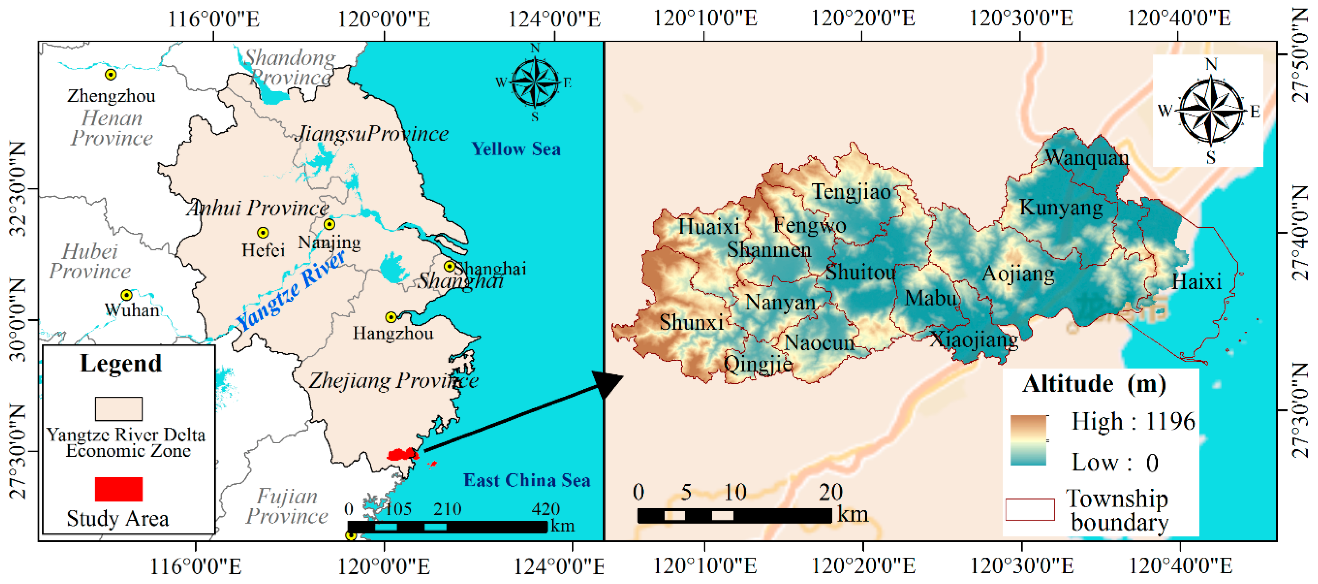
Figure 1. The location map of the study area.
Sustainability 14 10560 g001
Figure 2. Distribution of abandoned arable land in Pingyang County from 2000 to 2018.
Sustainability 14 10560 g002
Figure 3. The spatio-temporal changes in abandoned arable land rate in the study area from 2000 to 2018.
Sustainability 14 10560 g003
Figure 4. Spatio-temporal changes in PD and LPI indexes.
Sustainability 14 10560 g004
Figure 5. Spatio-temporal changes in MPS and LSI indexes.
Sustainability 14 10560 g005
Figure 6. Comparison between the prediction results of abandoned land and the actual results of abandoned land in 2018 ((a) represents actual distribution map of abandoned land in 2018, (b) represents the predicted distribution map of abandoned land in 2018 by the FLUS model, (cf) represents the distribution of abandoned arable land after local area enlargement).
Sustainability 14 10560 g006
Figure 7. The predicted distribution map of abandoned arable land in study area in 2028.
Sustainability 14 10560 g007
Figure 8. Spatial distribution of abandoned arable land rate in the study area in 2028.
Sustainability 14 10560 g008
Figure 9. Spatial changes map of landscape index in abandoned arable land area in 2028. (ad) represent PD, LPI, MPS and LSI, respectively.
Sustainability 14 10560 g009
Table 1. The area statistics of abandoned arable land of different towns in Pingyang County from 2000 to 2018 (unit: hm2).
Towns200020102018Area Increased between 2000–2018
Aojiang53.65298.14882.39828.74
Tengjiao83.5285.51745.29661.79
Shuitou76.44322.79555.38478.94
Nanyan8.84350.59447.41438.57
Shunxi19.79312.63449.57429.78
Huaixi11.63326.81416404.37
Fengwo48.17252.79419.47371.3
Naocun11.86138.46357.31345.45
Kunyang41.34193.68371.54330.2
Shanmen15.9235.58310.3294.4
Wanquan48.99176.34246.7197.71
Haixi4.8919.18182.36177.47
Mabu13.5162.52181.71168.2
Qingjie0.3330.11137.73137.4
Xiaojiang2.7551.7484.2481.49
Total441.583073.205797.405355.82
Abandoned arable land rate (%)0.422.955.46
Table 2. Analysis of landscape index of abandoned land in the study area from 2000 to 2018.
PD (Patches Number/hm2)LPI (%)MPS (hm2)LSI (m/hm2)
20000.00383.20511.120827.5642
20100.03351.47060.880879.7755
20180.60130.46490.9251109.4218
Table 3. Analysis of landscape index of abandoned area in the study area from 2018 to 2028.
PD (Patches Number/hm2)LPI (%)MPS (hm2)LSI (m/hm2)
20180.60130.46490.9251109.4218
20280.76241.64060.909380.5376
Publisher’s Note: MDPI stays neutral with regard to jurisdictional claims in published maps and institutional affiliations.