The Response Mechanisms of Topographic Changes in Small Loess Watershed under Rainstorm
Abstract
:1. Introduction
2. Materials and Methods
2.1. Experimental Materials
2.2. Experimental Methods
2.3. Data Processing
3. Results
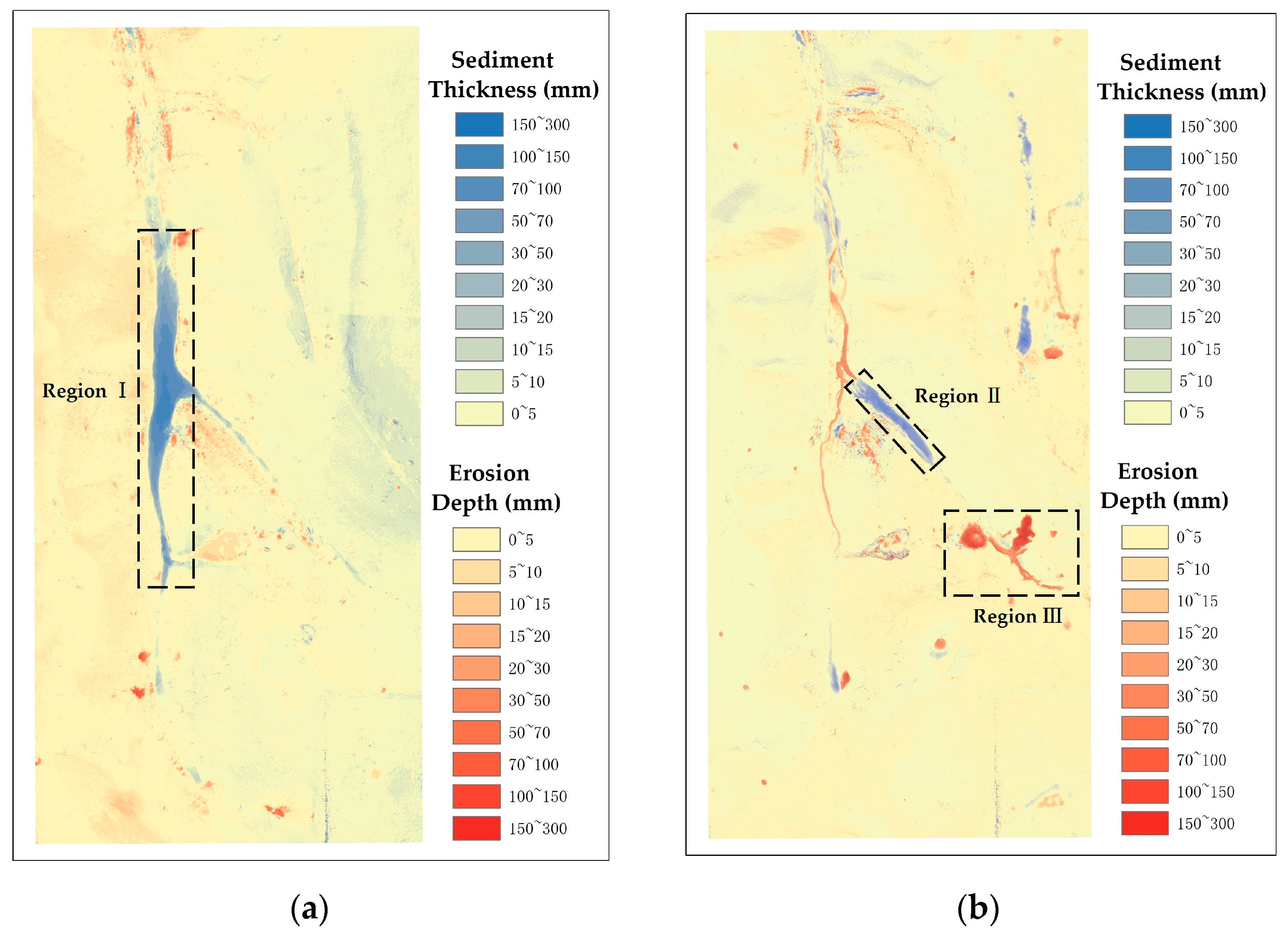
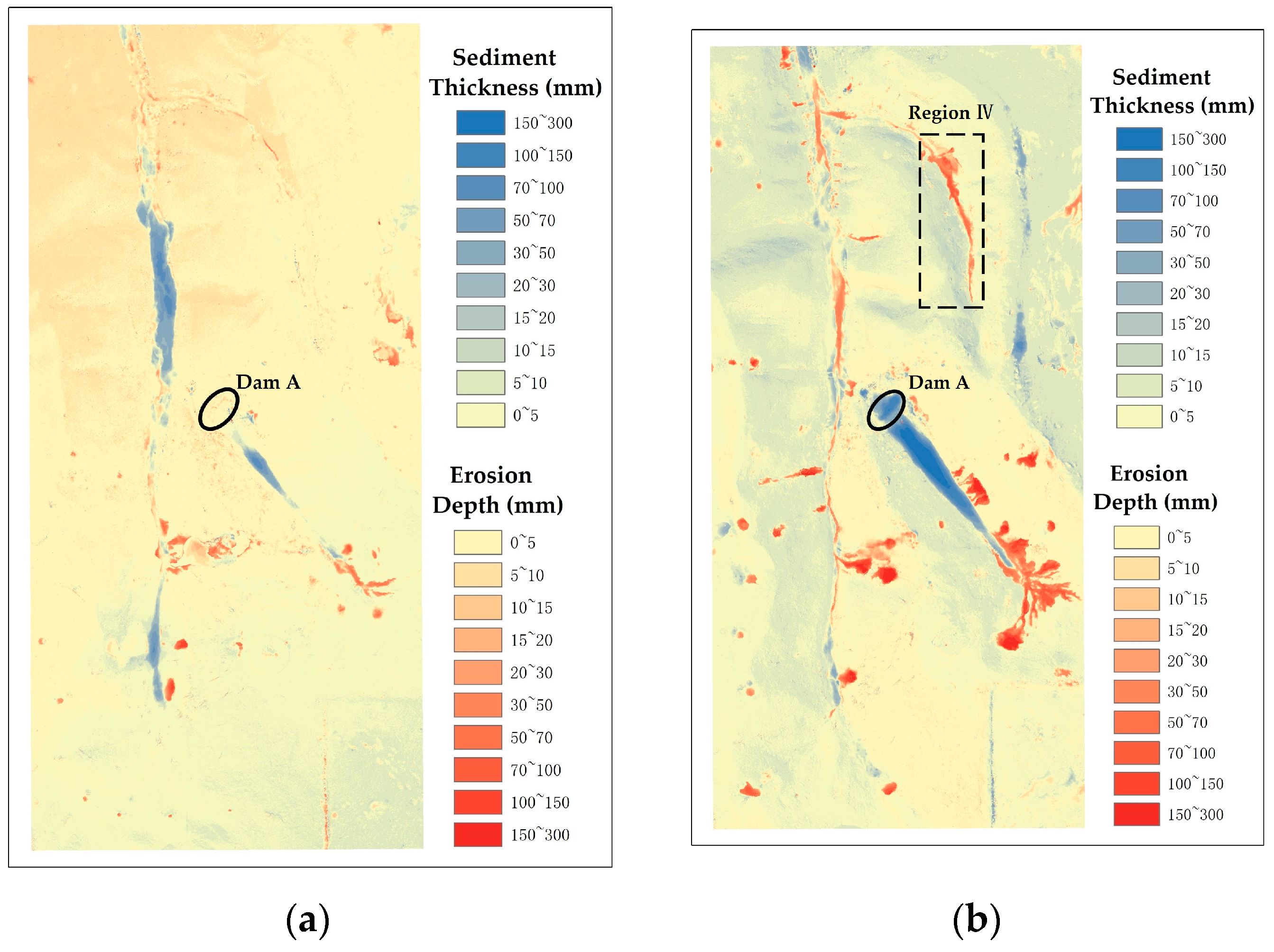
3.1. Response of Topographic Changes in Small Watershed to Silt Dam Layout
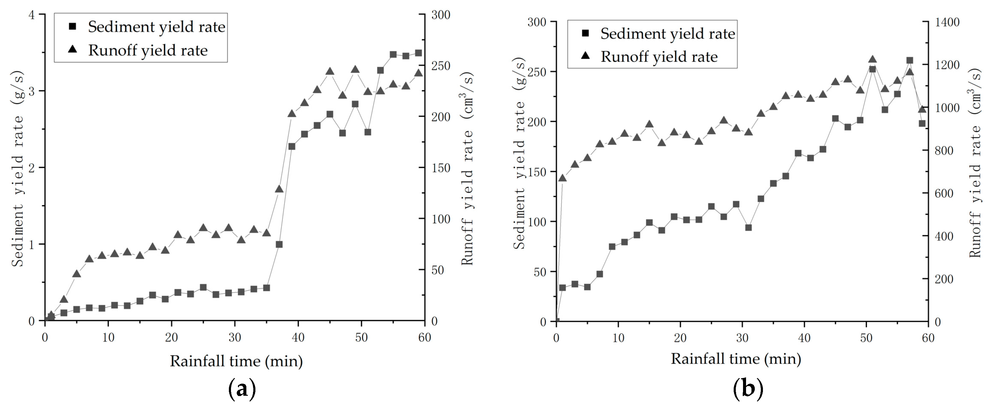
3.2. Response of Rainstorm Processes to Rainstorm Intensity in Small Watershed
4. Discussion
5. Conclusions
- (1)
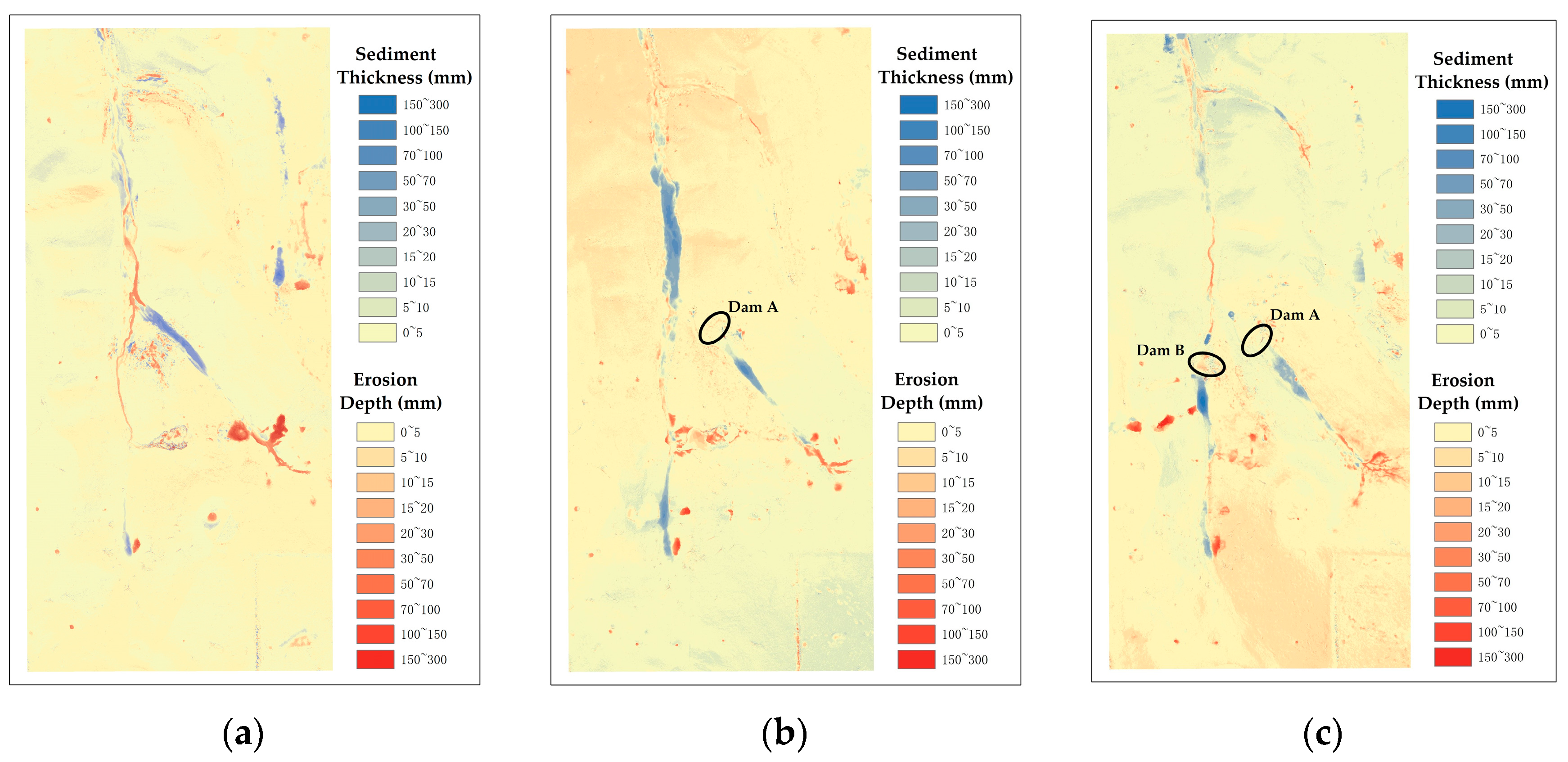
- Soil erosion in small watersheds under the action of rainfall can occur not only on the slope but also in the gully, but deposition usually occurs more often on the gentle slopes of the gully or in low-lying areas.
- (2)
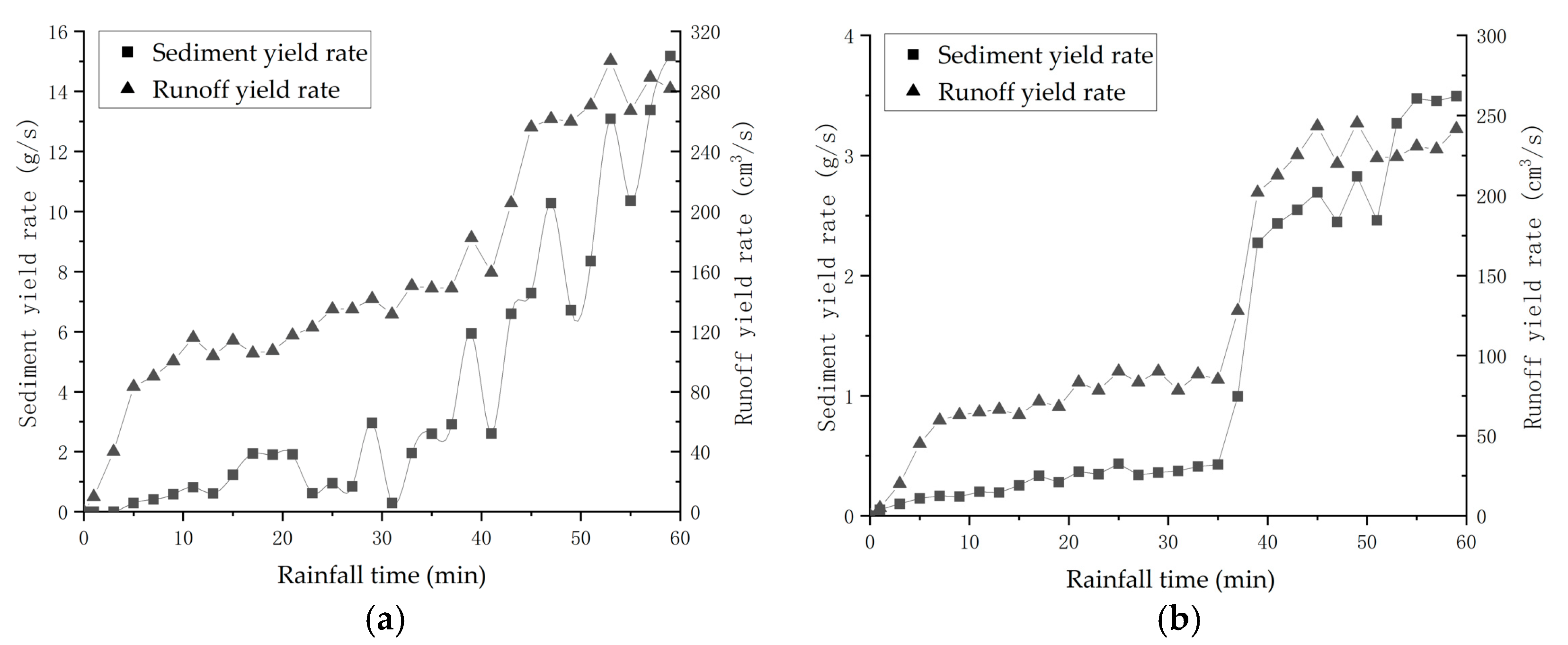
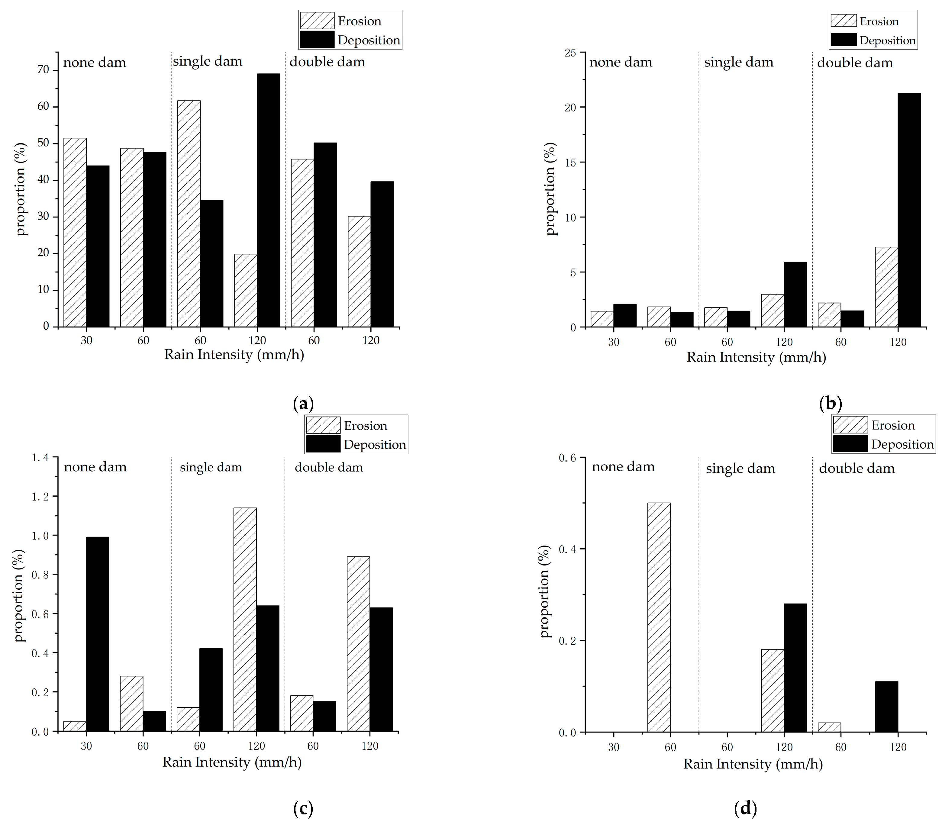
- The intensity of slope erosion in small watersheds is positively related to the rainfall intensity, and the greater the rainfall intensity, the deeper the depth of slope erosion. When the rain intensity is 120 mm/h, the runoff volume in the channel is high, and the channel is prone to erosion and less deposition, and conversely, when the rain intensity is 30 or 60 mm/h, the deposition phenomenon in the channel is obvious, and the erosion phenomenon is less.
- (3)
- A silt dam has a good role in the interception of ditch runoff sediment and can carry the runoff sediment effectively intercepted in front of the dam. The silt dam can also regulate the flow of runoff after the dam, from a certain degree to reduce the strength of the ditch erosion after the dam. Silt dam deployment can effectively reduce the loss of soil in the process of a rainstorm and play a role in water storage and soil preservation.
- (4)
- In a small watershed, the erosion depth and deposition thickness are mainly concentrated within 10 mm under the small and medium rainfall intensity (30, 60) mm/h. However, under heavy rainfall intensity of 120 mm/h, the proportion of soil erosion and deposition will increase greatly regardless of whether the silt dam is set in the small watershed. In other words, in small watersheds, soil and water conservation measures have a good effect on reducing runoff and sediment for medium- and small-intensity rainfall, but their effect on reducing runoff and sediment for high-intensity rainstorms will be attenuated. Therefore, rainfall is the dominant factor in the formation of erosion disasters.
Author Contributions
Funding
Institutional Review Board Statement
Informed Consent Statement
Data Availability Statement
Conflicts of Interest
References
- Easterling, D.R.; Meehl, G.A.; Parmesan, C.; Changnon, S.A.; Karl, T.R.; Mearns, L.O. Climate extremes: Observations, modeling, and impacts. Science 2019, 289, 2068–2074. [Google Scholar] [CrossRef] [PubMed] [Green Version]
- Sun, W.Y.; Mu, X.M.; Song, X.Y.; Wu, D.; Cheng, A.F.; Qiu, B. Changes in extreme temperature and precipitation events in the Loess Plateau (China) during 1960–2013 under global warming. Atmos. Res. 2016, 168, 33–48. [Google Scholar] [CrossRef]
- Farsi, N.; Mahjouri, N. Evaluating the Contribution of the Climate Change and Human Activities to Runoff Change under Uncertainty. J. Hydrol. 2019, 574, 872–891. [Google Scholar] [CrossRef]
- Niu, Y.; Wu, X.; Gao, Z.; Li, Y. Characteristics of soil erosion on engineering accumulation slope under the rainfall and inflow conditions. Trans. Chin. Soc. Agric. Eng. 2020, 36, 69–77. [Google Scholar] [CrossRef]
- Sharma, A.; Tiwari, K.N.; Bhadoria, P. Effect of land use land cover change on soil erosion potential in an agricultural watershed. Environ. Monit. Assess. 2010, 173, 789–801. [Google Scholar] [CrossRef]
- Wang, Z.J.; Jiao, J.Y.; Rayburg, S.; Wang, Q.L.; Su, Y. Soil erosion resistance of “Grain for Green” vegetation types under extreme rainfall conditions on the Loess Plateau, China. Catena 2016, 141, 109–116. [Google Scholar] [CrossRef]
- Chang, M.D. Soil Erosion in Small Watershed of Longdong Loess Plateau. Bull. Soil Water Conserv. 1986, 3, 44–49. [Google Scholar] [CrossRef]
- Gong, S.Y.; Jiang, D.L. Soil Erosion and Control of Small Watershed in Loess Hilly and Gully Area of Middle Yellow River. Sci. China 1978, 6, 671–678, 707. [Google Scholar]
- Jiang, D.L.; Zhao, C.X.; Chen, Z.L. Preliminary Analysis on Source of Runoff and Sediment in Small Watershed of Middle Yellow River. Acta Geogr. Sin. 1966, 1, 20–36. [Google Scholar]
- Chen, H.Y.; Cui, P.; Zhou, G.G.D.; Zhu, X.H.; Tang, J.B. Experimental study of debris flow caused by domino failures of landslide dams. Int. J. Sediment Res. 2014, 29, 414–422. [Google Scholar] [CrossRef]
- Cao, W.Z. The characteristics of rainstorm and flood in small watershed and its influence on river channel erosion and deposition—Taking the Gejin River and the Alingda River as examples. Water Resour. Power 2011, 29, 22–24, 43. [Google Scholar]
- Hou, J.; Liu, X.N.; Jiang, B.H.; Yang, F.G. Experimrntal study of water depth in steep channl flow carring sedients by mountain torrents. J. Hydraul. Eng. 2012, 43, 48–53. [Google Scholar] [CrossRef]
- Wischmeier, W.H.; Smith, D.D. Predicting Rainfall-Erosion Losses from Cropland East of the Rocky Mountains. 1965. Available online: https://xueshu.baidu.com/usercenter/paper/show?paperid=92bf731647ae487602f4b34368848d3d&site=xueshu_se (accessed on 22 May 2022).
- Wischmeier, W.H.; Smith, D.D. Predicting Rainfall Erosion Losses A Guide To Conservation Planning. 1978. Available online: https://xueshu.baidu.com/usercenter/paper/show?paperid=ce79cdb85a57324b5f094b598fadfb78&site=xueshu_se&hitarticle=1 (accessed on 22 May 2022).
- Imamoglu, A.; Dengiz, O. Determination of soil erosion risk using RUSLE model and soil organic carbon loss in Alaca catchment (Central Black Sea region, Turkey). Rend. Fis. Acc. Lincei 2016, 28, 11–23. [Google Scholar] [CrossRef]
- Phinzi, K.; Ngetar, N.S. The assessment of water-borne erosion at catchment level using GIS-based RUSLE and remote sensing: A review. Int. Soil Water Conserv. Res. 2019, 7, 27–46. [Google Scholar] [CrossRef]
- Verma, A.K.; Jha, M.K.; Mahana, R.K. Evaluation of HEC-HMS and WEPP for simulating watershed runoff using remote sensing and geographical information system. Paddy Water Environ. 2010, 8, 131–144. [Google Scholar] [CrossRef]
- Fernández, C.; Vega, J.A.; Vieira, D. Assessing soil erosion after fire and rehabilitation treatments in NW Spain: Performance of rusle and revised Morgan–Morgan–Finney models. Land Degrad. Dev. 2010, 21, 58–67. [Google Scholar] [CrossRef] [Green Version]
- Xu, Y.Q.; Shao, X.M. Estimation of soil erosion supported by GIS and RUSLE: A case study of Maotiaohe Watershed, Guizhou Province. J. Beijing For. Univ. 2006, 28, 67–71. [Google Scholar]
- Lazzari, M.; Gioia, D.; Piccarreta, M.; Danese, M.; Lanorte, A. Sediment yield and erosion rate estimation in the mountain catchments of the Camastra artificial reservoir (Southern Italy): A comparison between different empirical methods. Catena 2015, 139, 272–273. [Google Scholar] [CrossRef]
- Wang, J.; Hu, S.W.; Zhou, Y. Application of Artificial Simulation of Rainfall Devices to Soil and Water Conservation. Res. Soil Water Conserv. 2005, 4, 188–190, 194. [Google Scholar]
- Xu, X.Z.; Liu, D.Q.; Zhang, H.W.; Dong, Z.D.; Zhu, M.D. Experimental study on indoor simulated rainfall. J. Beijing For. Univ. 2006, 5, 52–58. [Google Scholar]
- Zhang, J.; Hu, Q.W.; Wang, S.H.; Ai, M.Y. Variation Trend Analysis of Runoff and Sediment Time Series Based on the R/S Analysis of Simulated Loess Tilled Slopes in the Loess Plateau, China. Sustainability 2018, 10, 17. [Google Scholar] [CrossRef] [Green Version]
- Zhang, P.; Yao, W.Y.; Liu, G.B.; Xiao, P.Q. Experimental study on soil erosion prediction model of loess slope based on rill morphology. Catena 2019, 173, 424–432. [Google Scholar] [CrossRef]
- Quan, X.; Shi, H.W.; Cai, Q.G.; He, J.J.; Zheng, M.G.; Sun, L.Y.; Fang, H.Y. Experimental study on the settlement of loess slope under indoor simulated rainfall. J. Shaanxi Norm. Univ. Nat. Sci. Ed. 2021, 49, 98–106. [Google Scholar] [CrossRef]
- Zhang, P.; Zheng, F.L.; Wang, B.; Chen, J.Q.; Ding, X.B. Comparative Study of Monitoring Gully Erosion Morphology Change Process by Using High Precision GPS, Leica HDS 3000 Laser Scanner and Needle Board Method. Bull. Soil Water Conserv. 2008, 5, 11–15, 20. [Google Scholar]
- Day, S.S.; Gran, K.B.; Belmont, P.; Wawrzyniec, T. Measuring bluff erosion part 1: Terrestrial laser scanning methods for change detection. Earth Surf. Process. Landf. 2013, 38, 1055–1067. [Google Scholar] [CrossRef]
- Zhang, P.; Tang, H.W.; Yao, W.Y.; Zhang, N.; Lv, X.Z. Experimental investigation of morphological characteristics of rill evolution on loess slope. Catena 2016, 137, 536–544. [Google Scholar] [CrossRef]
- Vinci, A.; Brigante, R.; Todisco, F.; Mannocchi, F.; Radicioni, F. Measuring rill erosion by laser scanning. Catena 2015, 124, 97–108. [Google Scholar] [CrossRef]
- Seeger, M. Uncertainty of factors determining runoff and erosion processes as quantified by rainfall simulations. Catena 2007, 71, 56–67. [Google Scholar] [CrossRef]
- Zhang, P.; Yao, W.Y.; Tang, H.W.; Xiao, P.Q. Rill morphology change and its effect on erosio and sediment yield on loess slope. Trans. Chin. Soc. Agric. Eng. 2018, 34, 114–119. [Google Scholar] [CrossRef]
- Xue, S.B.; Li, P.; Shen, Z.Z.; Su, Y.Y. Study on sediment deposition processes under rainfall conditions. J. Sediment Res. 2021, 46, 55–60. [Google Scholar] [CrossRef]
- Xiao, P.Q.; Wang, L.L.; Yang, J.S.; Jiao, P.; Wang, Z.H. Study on sediment reduction benefits of soil and water consrevation measures in typical watersheds in the Loess Plateau under heavy rainfall. Shuili Xuebao 2020, 51, 1149–1156. [Google Scholar] [CrossRef]
- Xu, J.H.; Jin, S.Y.; Gao, Y.J.; Gao, W.Y. Analysis of the Effect of Water and Soil Conservation Measures on Storm Water and Sediment Reduction of the Flood on July 26, 2017. Yellow River 2017, 39, 22–26. [Google Scholar]
| Name | Scale Similarity Criteria and Symbols | Scale | |
|---|---|---|---|
| Geometric similarity | Horizontal scale | 40.0 | |
| Vertical scale | 40.0 | ||
| Rainfall similarity | Rain intensity scale | 6.3 | |
| Similarity of flow movement | Velocity scale | 6.3 | |
| Flow scale | 10,119.3 | ||
| Roughness scale | 1.8 | ||
| Time scale of flow | 6.3 | ||
| Similarity law of incipient | 6.3 | ||
| Similar soil water | Soil water content scale | 1.0 | |
| Infiltration Scale | 6.3 | ||
| Number of Dams | Rain Intensity Setting (mm/h) | |
|---|---|---|
| No dams | 30 | 60 |
| Single dam | 60 | 120 |
| Double dam | 60 | 120 |
| Number of Dam Layouts | Rainfall Intensity (mm/h) | Runoff Yield (L) | Sediment Yield (kg) |
|---|---|---|---|
| Double dam | 60 | 444.84 | 4.26 |
| Single dam | 60 | 563.25 | 13.78 |
| Double dam | 120 | 3345.62 | 464.82 |
Publisher’s Note: MDPI stays neutral with regard to jurisdictional claims in published maps and institutional affiliations. |
© 2022 by the authors. Licensee MDPI, Basel, Switzerland. This article is an open access article distributed under the terms and conditions of the Creative Commons Attribution (CC BY) license (https://creativecommons.org/licenses/by/4.0/).
Share and Cite
Yao, Z.; Yang, J.; Zhang, P.; Zhang, Y.; Liu, L.; Zhao, D. The Response Mechanisms of Topographic Changes in Small Loess Watershed under Rainstorm. Sustainability 2022, 14, 10472. https://doi.org/10.3390/su141710472
Yao Z, Yang J, Zhang P, Zhang Y, Liu L, Zhao D. The Response Mechanisms of Topographic Changes in Small Loess Watershed under Rainstorm. Sustainability. 2022; 14(17):10472. https://doi.org/10.3390/su141710472
Chicago/Turabian StyleYao, Zhihong, Jianchen Yang, Pan Zhang, Yu Zhang, Liwei Liu, and Dongbao Zhao. 2022. "The Response Mechanisms of Topographic Changes in Small Loess Watershed under Rainstorm" Sustainability 14, no. 17: 10472. https://doi.org/10.3390/su141710472
APA StyleYao, Z., Yang, J., Zhang, P., Zhang, Y., Liu, L., & Zhao, D. (2022). The Response Mechanisms of Topographic Changes in Small Loess Watershed under Rainstorm. Sustainability, 14(17), 10472. https://doi.org/10.3390/su141710472


