
Comparison between CMIP5 and CMIP6 Models over MENA Region Using Historical Simulations and Future Projections

 ,
,  ,
, 

Abstract
:1. Introduction
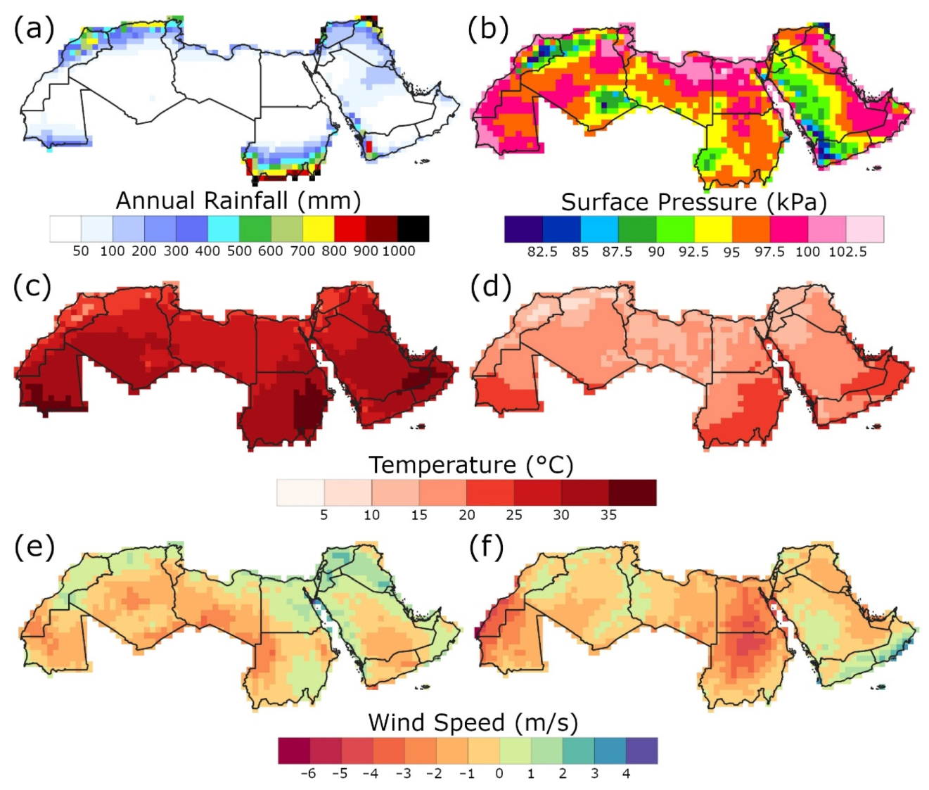
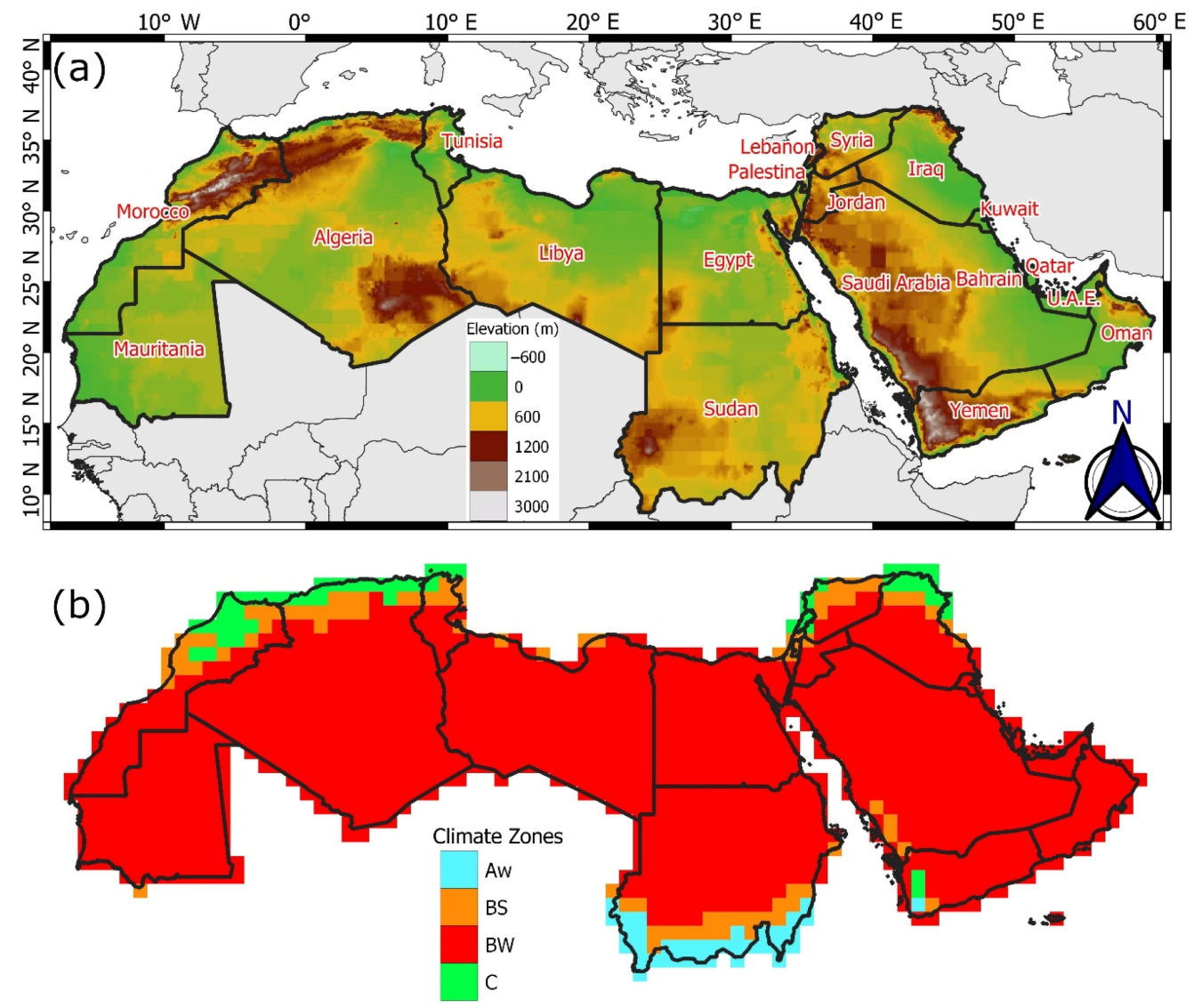
2. Study Region
3. Data
3.1. Gridded Dataset
3.2. CMIP5 and CMIP6 GCMs
4. Methodology
4.1. Historical Evaluation
4.2. Future Projections
5. Results
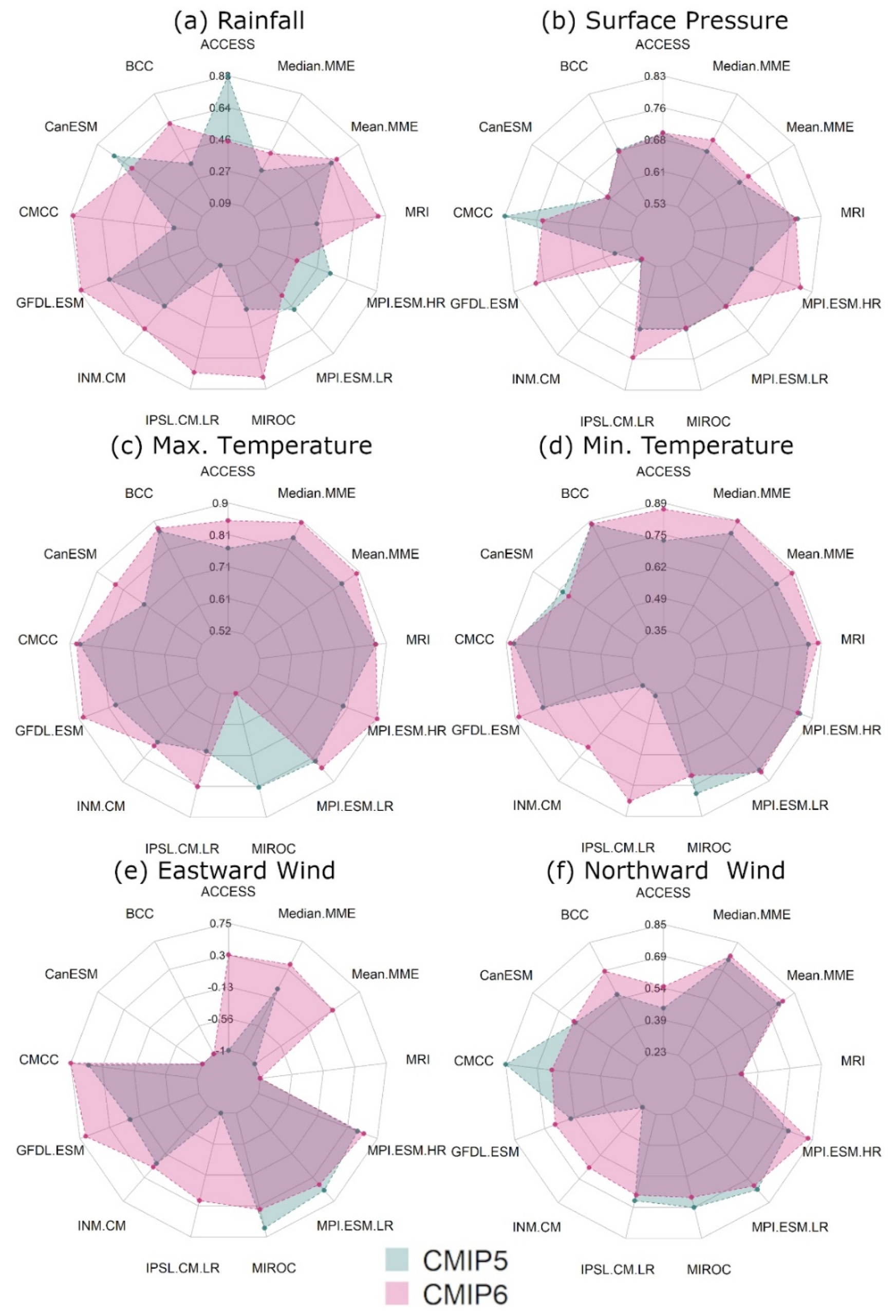
5.1. Historical Evaluation Skills of GCMs
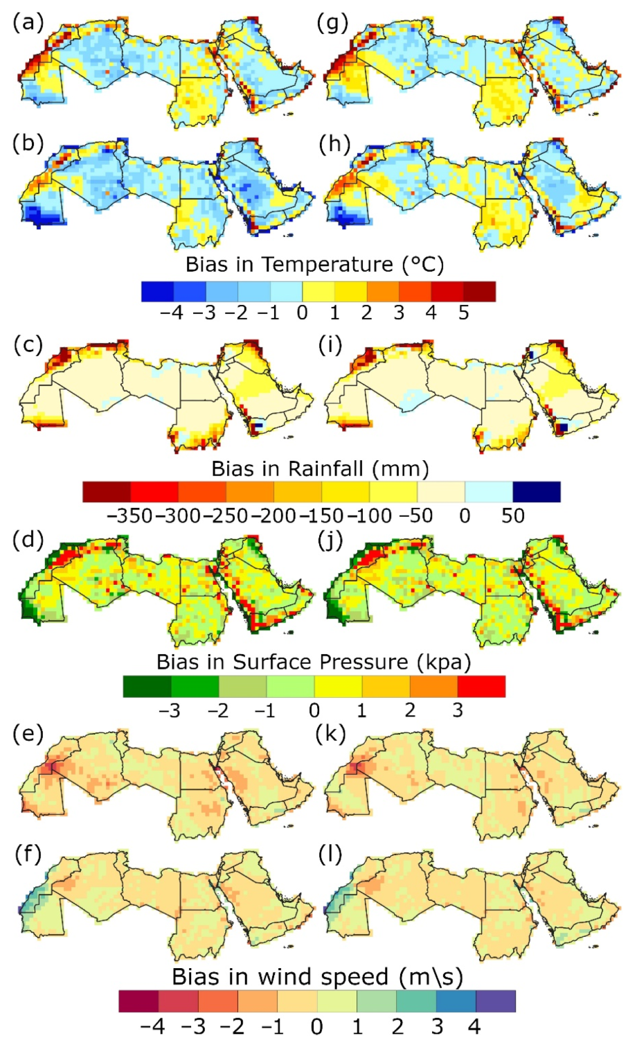
5.2. Median MME Bias Spatial Distribution
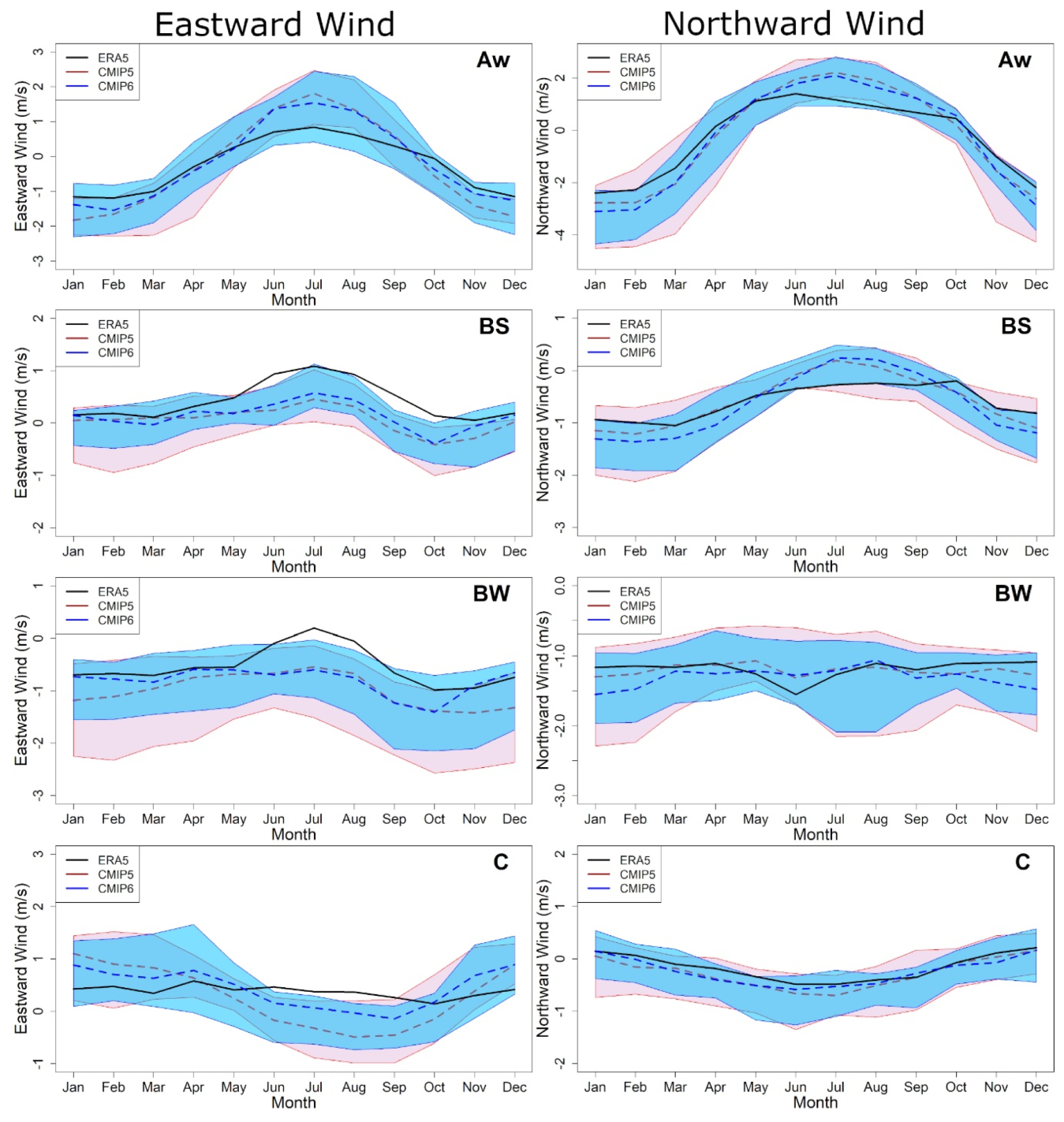
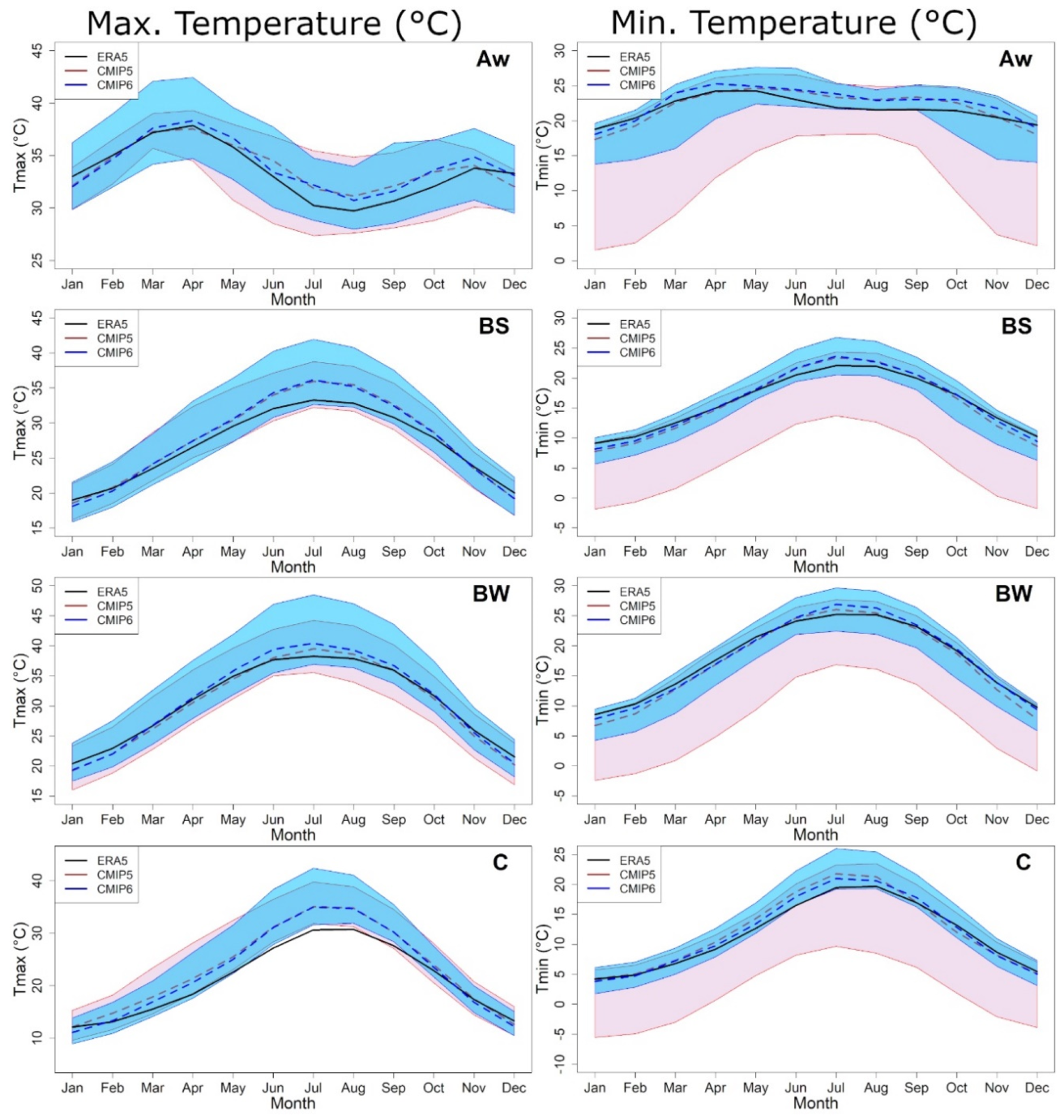
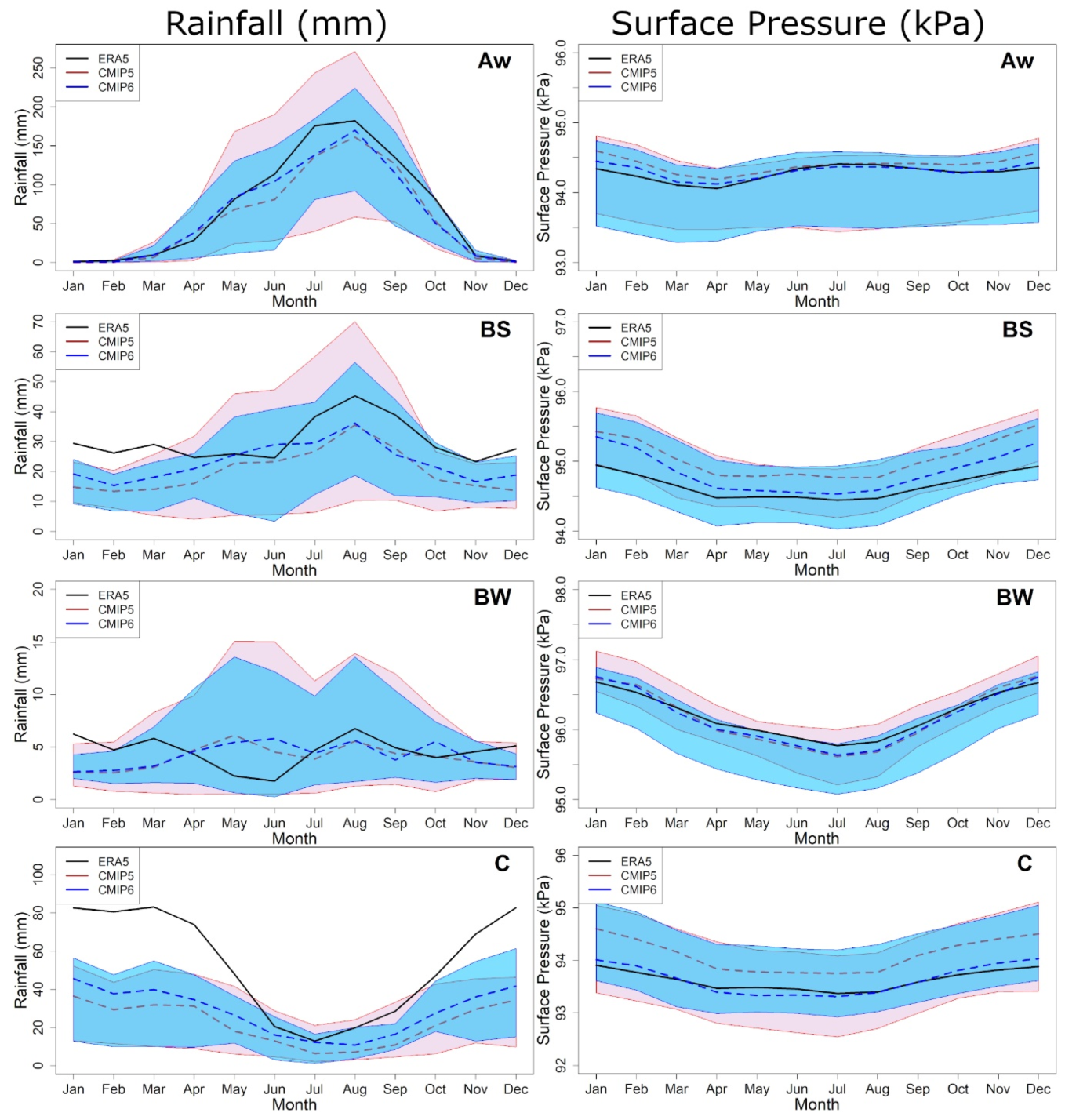
5.3. Seasonal Variability
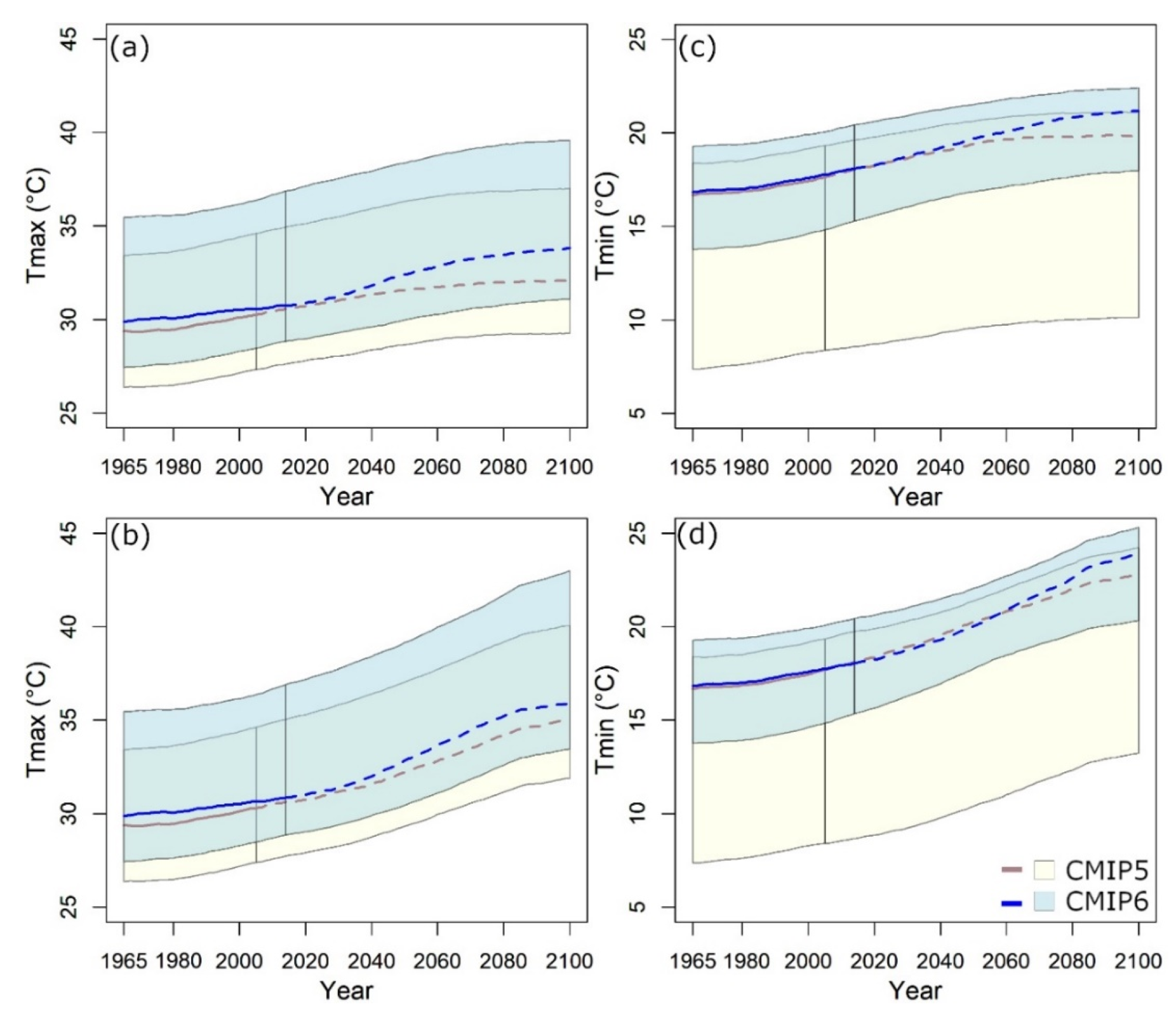
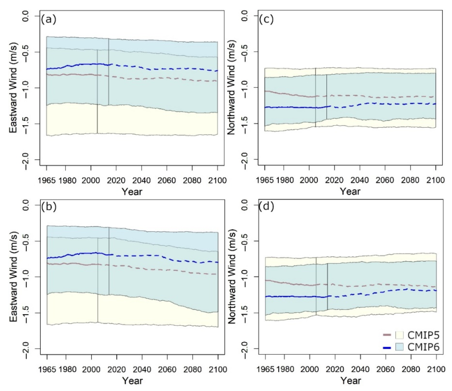
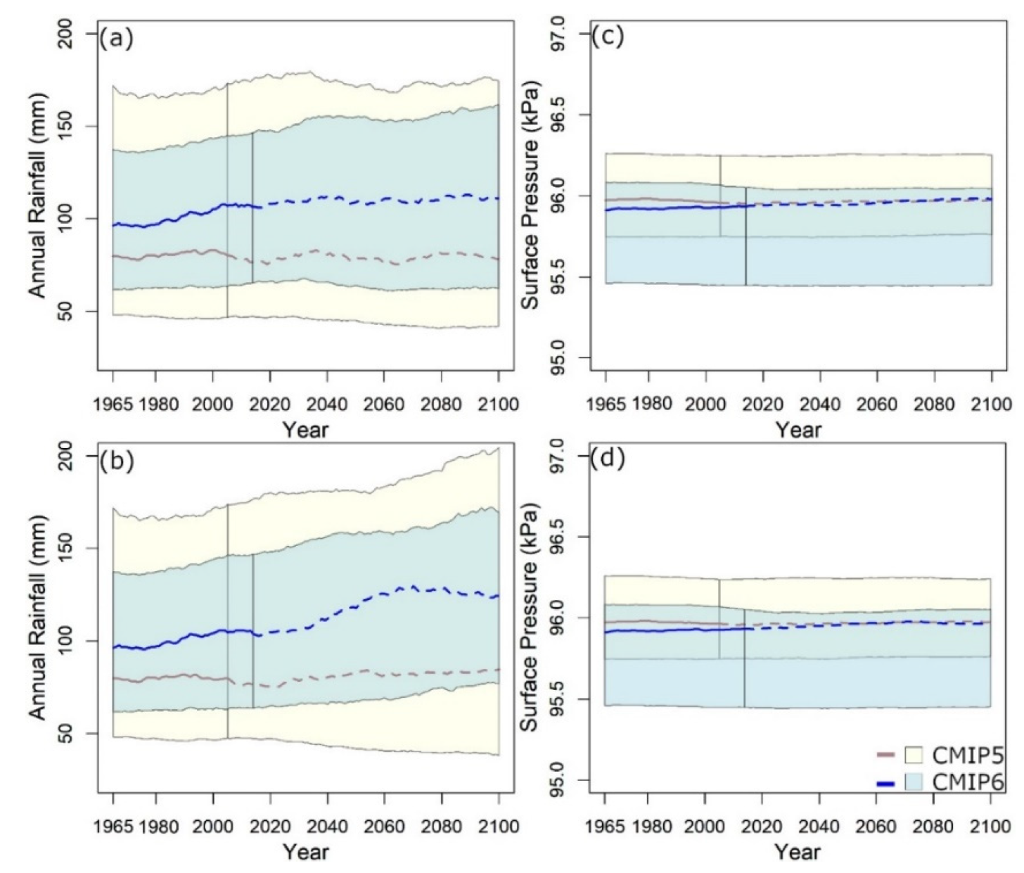
5.4. Annual Variable Projection
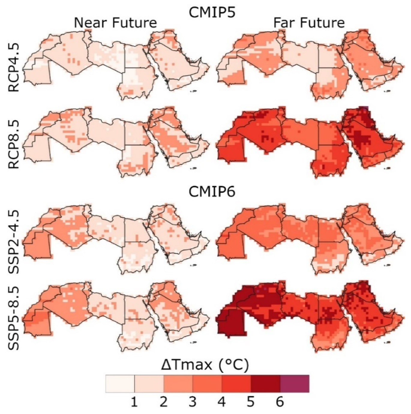
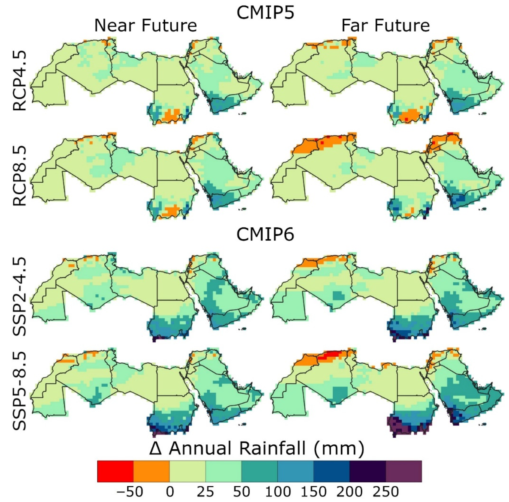
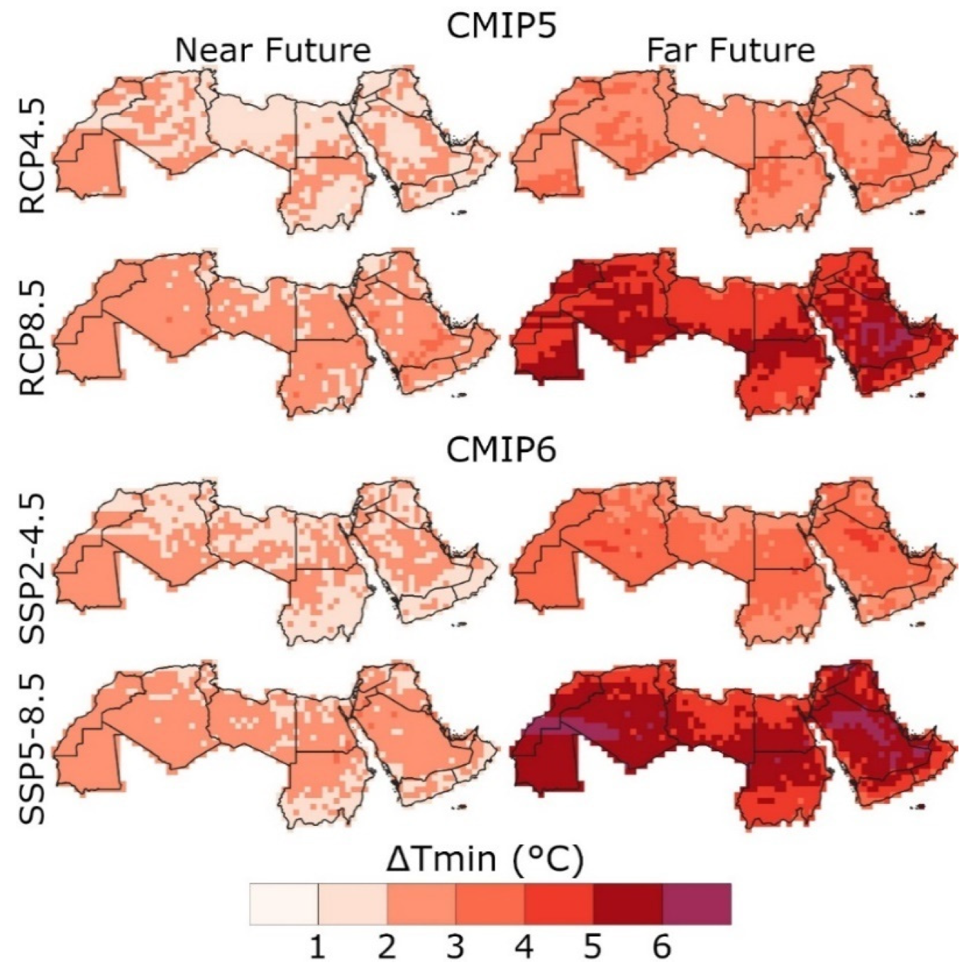
5.5. Spatial Changes of Both CMIP5 and CMIP6
6. Discussion
7. Conclusions
Supplementary Materials
Author Contributions
Funding
Institutional Review Board Statement
Informed Consent Statement
Data Availability Statement
Conflicts of Interest
References
- Shiru, M.S.; Chung, E.S.; Shahid, S.; Wang, X. jun Comparison of precipitation projections of CMIP5 and CMIP6 global climate models over Yulin, China. Theor. Appl. Climatol. 2022, 147, 535–548. [Google Scholar] [CrossRef]
- Salman, S.A.; Shahid, S.; Afan, H.A.; Shiru, M.S.; Al-Ansari, N.; Yaseen, Z.M. Changes in climatic water availability and crop water demand for Iraq region. Sustainability 2020, 12, 3437. [Google Scholar] [CrossRef] [Green Version]
- Nashwan, M.S.; Shahid, S. Future precipitation changes in Egypt under the 1.5 and 2.0 °C global warming goals using CMIP6 multimodel ensemble. Atmos. Res. 2022, 265, 105908. [Google Scholar] [CrossRef]
- Hamed, M.M.; Nashwan, M.S.; Shahid, S. A novel selection method of CMIP6 GCMs for robust climate projection. Int. J. Climatol. 2022, 42, 4258–4272. [Google Scholar] [CrossRef]
- Salehie, O.; Ismail, T.B.; Hamed, M.M.; Shahid, S.; Idlan Muhammad, M.K. Projection of Hot and Cold Extremes in the Amu River Basin of Central Asia using GCMs CMIP6. Stoch. Environ. Res. Risk Assess. 2022, 1–22. [Google Scholar] [CrossRef]
- Salehie, O.; Hamed, M.M.; Ismail, T.; Tam, T.H.; Shahid, S. Selection of CMIP6 GCM With Projection of Climate over the Amu Darya River Basin. Prepr. Available Res. Sq. 2021, 1–27. [Google Scholar] [CrossRef]
- Khan, N.; Shahid, S.; Sharafati, A.; Yaseen, Z.M.; Ismail, T.; Ahmed, K.; Nawaz, N. Determination of cotton and wheat yield using the standard precipitation evaporation index in Pakistan. Arab. J. Geosci. 2021, 14, 2035. [Google Scholar] [CrossRef]
- Shiru, M.S.; Shahid, S.; Dewan, A.; Chung, E.-S.; Alias, N.; Ahmed, K.; Hassan, Q.K. Projection of meteorological droughts in Nigeria during growing seasons under climate change scenarios. Sci. Rep. 2020, 10, 10107. [Google Scholar] [CrossRef]
- Iqbal, Z.; Shahid, S.; Ahmed, K.; Ismail, T.; Ziarh, G.; Chung, E.-S.; Wang, X. Evaluation of CMIP6 GCM rainfall in mainland Southeast Asia. Atmos. Res. 2021, 254, 105525. [Google Scholar] [CrossRef]
- Mohsenipour, M.; Shahid, S.; Chung, E.S.; Wang, X.J. Changing Pattern of Droughts during Cropping Seasons of Bangladesh. Water Resour. Manag. 2018, 32, 1555–1568. [Google Scholar] [CrossRef]
- Salehie, O.; Hamed, M.M.; Ismail, T.B.; Shahid, S. Projection of droughts in Amu river basin for shared socioeconomic pathways CMIP6. Theor. Appl. Climatol. 2022, 1–19. [Google Scholar] [CrossRef]
- Khan, N.; Shahid, S.; Ismail, T.B.; Behlil, F. Prediction of heat waves over Pakistan using support vector machine algorithm in the context of climate change. Stoch. Environ. Res. Risk Assess. 2021, 35, 1335–1353. [Google Scholar] [CrossRef]
- Khan, N.; Shahid, S.; Ismail, T.; Ahmed, K.; Nawaz, N. Trends in heat wave related indices in Pakistan. Stoch. Environ. Res. Risk Assess. 2019, 33, 287–302. [Google Scholar] [CrossRef]
- Sammen, S.S.; Mohammed, T.A.; Ghazali, A.H.; Sidek, L.M.; Shahid, S.; Abba, S.I.; Malik, A. Assessment of Climate Change Impact on Probable Maximum Floods in a Tropical Catchment. Theor. Appl. Climatol. 2021, 148, 15–31. [Google Scholar]
- Tam, T.H.; Rahman, M.Z.A.; Harun, S.; Try, S.; Shahid, S.; Jamal, M.H.; Ismail, Z.; Razak, K.A.; Ghani, M.K.; Wahab, Y.F.A. Flood Hazard Assessment under Climate Change Scenarios in Kelantan River Basin, Malaysia. Res. Sq. 2021. [Google Scholar] [CrossRef]
- Shrestha, S.; Lohpaisankrit, W. Flood hazard assessment under climate change scenarios in the Yang River Basin, Thailand. Int. J. Sustain. Built Environ. 2017, 6, 285–298. [Google Scholar] [CrossRef] [Green Version]
- Sun, J.; Wang, X.; Shahid, S. Precipitation and runoff variation characteristics in typical regions of North China Plain: A case study of Hengshui City. Theor. Appl. Climatol. 2020, 142, 971–985. [Google Scholar] [CrossRef]
- Wu, H.; Wang, X.; Shahid, S.; Ye, M. Changing characteristics of the water consumption structure in Nanjing city, southern China. Water 2016, 8, 314. [Google Scholar] [CrossRef] [Green Version]
- Sediqi, M.N.; Shiru, M.S.; Nashwan, M.S.; Ali, R.; Abubaker, S.; Wang, X.; Ahmed, K.; Shahid, S.; Asaduzzaman, M.; Manawi, S.M.A. Spatio-temporal pattern in the changes in availability and sustainability ofwater resources in Afghanistan. Sustainability 2019, 11, 5836. [Google Scholar] [CrossRef] [Green Version]
- Mukherjee, S.; Mishra, A.; Trenberth, K.E. Climate Change and Drought: A Perspective on Drought Indices. Curr. Clim. Chang. Rep. 2018, 4, 145–163. [Google Scholar] [CrossRef]
- Salman, S.A.; Shahid, S.; Sharafati, A.; Salem, G.S.A.; Bakar, A.A.; Farooque, A.A.; Chung, E.S.; Ahmed, Y.A.; Mikhail, B.; Yaseen, Z.M. Projection of agricultural water stress for climate change scenarios: A regional case study of Iraq. Agriculture 2021, 11, 1288. [Google Scholar]
- Hossain, M.S.; Qian, L.; Arshad, M.; Shahid, S.; Fahad, S.; Akhter, J. Climate change and crop farming in Bangladesh: An analysis of economic impacts. Int. J. Clim. Chang. Strateg. Manag. 2019, 11, 424–440. [Google Scholar] [CrossRef]
- Wahiduzzaman, M.; Ali, M.A.; Luo, J.-J.; Wang, Y.; Uddin, M.J.; Shahid, S.; Islam, A.R.M.T.; Mondal, S.K.; Siddiki, U.R.; Bilal, M.; et al. Effects of convective available potential energy, temperature and humidity on the variability of thunderstorm frequency over Bangladesh. Theor. Appl. Climatol. 2022, 147, 325–346. [Google Scholar] [CrossRef]
- Shourav, M.S.A.; Shahid, S.; Singh, B.; Mohsenipour, M.; Chung, E.-S.; Wang, X.-J. Potential Impact of Climate Change on Residential Energy Consumption in Dhaka City. Environ. Model. Assess. 2018, 23, 131–140. [Google Scholar] [CrossRef]
- Shahid, S. Probable impacts of climate change on public health in Bangladesh. Asia Pac. J. Public Heal 2010, 22, 310–319. [Google Scholar] [CrossRef]
- Khan, M.A.; Majeed, R.; Fatima, S.U.; Khan, M.A.; Shaukat, S.S. Occurrence, distribution and health effects of heavy metals in commercially available vegetables in Karachi. Int. J. Biol. Biotechnol. 2020, 17, 319–328. [Google Scholar]
- Hamed, M.M.; Nashwan, M.S.; Shahid, S.; Ismail, T.B.; Wang, X.J.; Dewan, A.; Asaduzzaman, M. Inconsistency in historical simulations and future projections of temperature and rainfall: A comparison of CMIP5 and CMIP6 models over Southeast Asia. Atmos. Res. 2022, 265, 105927. [Google Scholar] [CrossRef]
- Hartmann, D.L. Chapter 11—Global Climate Models. In Global Physical Climatology, 2nd, ed.; Elsevier: Boston, MA, USA, 2016; pp. 325–360. ISBN 978-0-12-328531-7. [Google Scholar]
- Taylor, K.E.; Balaji, V.; Hankin, S.; Juckes, M.; Lawrence, B.; Pascoe, S. CMIP5 Data Reference Syntax (DRS) and Controlled Vocabularies; San Francisco Bay Area: San Francisco, CA, USA, 2011. [Google Scholar]
- Weigel, A.P.; Knutti, R.; Liniger, M.A.; Appenzeller, C. Risks of model weighting in multimodel climate projections. J. Clim. 2010, 23, 4175–4191. [Google Scholar] [CrossRef]
- Hamed, M.M.; Nashwan, M.S.; Shahid, S. Inter-comparison of Historical Simulation and Future Projection of Rainfall and Temperature by CMIP5 and CMIP6 GCMs Over Egypt. Int. J. Climatol. 2022, 42, 4316–4332. [Google Scholar] [CrossRef]
- Song, Y.H.; Nashwan, M.S.; Chung, E.S.; Shahid, S. Advances in CMIP6 INM-CM5 over CMIP5 INM-CM4 for precipitation simulation in South Korea. Atmos. Res. 2021, 247, 105261. [Google Scholar] [CrossRef]
- Eyring, V.; Bony, S.; Meehl, G.A.; Senior, C.A.; Stevens, B.; Stouffer, R.J.; Taylor, K.E. Overview of the Coupled Model Intercomparison Project Phase 6 (CMIP6) experimental design and organization. Geosci. Model Dev. 2016, 9, 1937–1958. [Google Scholar] [CrossRef] [Green Version]
- Baker, N.C.; Huang, H.P. A comparative study of precipitation and evaporation between CMIP3 and CMIP5 climate model ensembles in semiarid regions. J. Clim. 2014, 27, 3731–3749. [Google Scholar] [CrossRef]
- Onyutha, C.; Tabari, H.; Rutkowska, A.; Nyeko-Ogiramoi, P.; Willems, P. Comparison of different statistical downscaling methods for climate change rainfall projections over the Lake Victoria basin considering CMIP3 and CMIP5. J. Hydro-Environ. Res. 2016, 12, 31–45. [Google Scholar] [CrossRef]
- Sun, Q.; Miao, C.; Duan, Q. Comparative analysis of CMIP3 and CMIP5 global climate models for simulating the daily mean, maximum, and minimum temperatures and daily precipitation over China. J. Geophys. Res. Atmos. 2015, 120, 4806–4824. [Google Scholar] [CrossRef]
- O’Neill, B.C.; Tebaldi, C.; Van Vuuren, D.P.; Eyring, V.; Friedlingstein, P.; Hurtt, G.; Knutti, R.; Kriegler, E.; Lamarque, J.F.; Lowe, J.; et al. The Scenario Model Intercomparison Project (ScenarioMIP) for CMIP6. Geosci. Model Dev. 2016, 9, 3461–3482. [Google Scholar] [CrossRef] [Green Version]
- Moss, R.H.; Edmonds, J.A.; Hibbard, K.A.; Manning, M.R.; Rose, S.K.; van Vuuren, D.P.; Carter, T.R.; Emori, S.; Kainuma, M.; Kram, T.; et al. The next generation of scenarios for climate change research and assessment. Nature 2010, 463, 747–756. [Google Scholar] [CrossRef]
- Chen, H.; Sun, J.; Lin, W.; Xu, H. Comparison of CMIP6 and CMIP5 models in simulating climate extremes. Sci. Bull. 2020, 65, 1415–1418. [Google Scholar] [CrossRef]
- Song, Y.H.; Chung, E.S.; Shahid, S. Spatiotemporal differences and uncertainties in projections of precipitation and temperature in South Korea from CMIP6 and CMIP5 general circulation models. Int. J. Climatol. 2021, 41, 5899–5919. [Google Scholar] [CrossRef]
- Ortega, G.; Arias, P.A.; Villegas, J.C.; Marquet, P.A.; Nobre, P. Present-day and future climate over central and South America according to CMIP5/CMIP6 models. Int. J. Climatol. 2021, 41, 6713–6735. [Google Scholar] [CrossRef]
- Zamani, Y.; Hashemi Monfared, S.A.; Azhdari Moghaddam, M.; Hamidianpour, M. A comparison of CMIP6 and CMIP5 projections for precipitation to observational data: The case of Northeastern Iran. Theor. Appl. Climatol. 2020, 142, 1613–1623. [Google Scholar] [CrossRef]
- Chen, C.-A.; Hsu, H.-H.; Liang, H.-C. Evaluation and comparison of CMIP6 and CMIP5 model performance in simulating the seasonal extreme precipitation in the Western North Pacific and East Asia. Weather Clim. Extrem. 2021, 31, 100303. [Google Scholar] [CrossRef]
- Ayugi, B.; Jiang, Z.; Zhu, H.; Ngoma, H.; Babaousmail, H.; Karim, R.; Dike, V. Comparison of CMIP6 and CMIP5 models in simulating mean and extreme precipitation over East Africa. Int. J. Climatol. 2021, 41, 6474–6496. [Google Scholar] [CrossRef]
- Bourdeau-Goulet, S.C.; Hassanzadeh, E. Comparisons Between CMIP5 and CMIP6 Models: Simulations of Climate Indices Influencing Food Security, Infrastructure Resilience, and Human Health in Canada. Earth’s Future 2021, 9, e2021EF001995. [Google Scholar] [CrossRef]
- Lun, Y.; Liu, L.; Cheng, L.; Li, X.; Li, H.; Xu, Z. Assessment of GCMs simulation performance for precipitation and temperature from CMIP5 to CMIP6 over the Tibetan Plateau. Int. J. Climatol. 2021, 41, 3994–4018. [Google Scholar] [CrossRef]
- AFED. Arab Environment in 10 Years. Annual Report of Arab Forum for Environment and Development; Saab, N., Ed.; Annual Report of Arab Forum for Environment and Development; Arab Forum for Environment and Development: Beirut, Lebanon, 2017. [Google Scholar]
- Majdi, F.; Asaad, S.; Alireza, H.; Maryam, K.; Sara, K. Future projection of precipitation and temperature changes in the Middle East and North Africa (MENA) region based on CMIP6. Theor. Appl. Climatol. 2022, 147, 1249–1262. [Google Scholar] [CrossRef]
- Masson-Delmotte, V.; Zhai, P.; Pirani, A.; Connors, S.L.; Péan, C.; Berger, S.; Caud, N.; Chen, Y.; Goldfarb, L.; Gomis, M.I.; et al. IPCC Summary for Policymakers. In Climate Change 2021: The Physical Science Basis. Contribution of Working Group I to the Sixth Assessment Report of the Intergovernmental Panel on Climate Change; Cambridge University Press: Cambridge, UK, 2021. [Google Scholar]
- Pal, J.S.; Eltahir, E.A.B. Future temperature in southwest Asia projected to exceed a threshold for human adaptability. Nat. Clim. Chang. 2016, 6, 197–200. [Google Scholar] [CrossRef]
- Peel, M.C.; Finlayson, B.L.; McMahon, T.A. Updated world map of the Köppen-Geiger climate classificatio. Hydrol. Earth Syst. Sci. 2007, 11, 1633–1644. [Google Scholar] [CrossRef]
- Hersbach, H.; Bell, B.; Berrisford, P.; Hirahara, S.; Horányi, A.; Muñoz-Sabater, J.; Nicolas, J.; Peubey, C.; Radu, R.; Schepers, D.; et al. The ERA5 global reanalysis. Q. J. R. Meteorol. Soc. 2020, 146, 1999–2049. [Google Scholar] [CrossRef]
- Nashwan, M.S.; Shahid, S.; Dewan, A.; Ismail, T.; Alias, N. Performance of five high resolution satellite-based precipitation products in arid region of Egypt: An evaluation. Atmos. Res. 2020, 236, 104809. [Google Scholar] [CrossRef]
- Hamed, M.M.; Nashwan, M.S.; Shahid, S. Performance Evaluation of Reanalysis Precipitation Products in Egypt using Fuzzy Entropy Time Series Similarity Analysis. Int. J. Climatol. 2021, 41, 5431–5446. [Google Scholar] [CrossRef]
- Nashwan, M.S.; Shahid, S.; Chung, E.-S.S. Development of high-resolution daily gridded temperature datasets for the central north region of Egypt. Sci. Data 2019, 6, 138. [Google Scholar] [CrossRef] [PubMed] [Green Version]
- Hamed, M.M.; Nashwan, M.S.; Shahid, S. Climatic zonation of Egypt based on high-resolution dataset using image clustering technique. Prog. Earth Planet. Sci. 2022, 9, 35. [Google Scholar] [CrossRef]
- Khadka, D.; Babel, M.S.; Abatan, A.A.; Collins, M. An evaluation of CMIP5 and CMIP6 climate models in simulating summer rainfall in the Southeast Asian monsoon domain. Int. J. Climatol. 2022, 42, 1181–1202. [Google Scholar] [CrossRef]
- Zuluaga, C.F.; Avila-Diaz, A.; Justino, F.B.; Wilson, A.B. Climatology and trends of downward shortwave radiation over Brazil. Atmos. Res. 2021, 250, 105347. [Google Scholar] [CrossRef]
- Rivera, J.A.; Arnould, G. Evaluation of the ability of CMIP6 models to simulate precipitation over Southwestern South America: Climatic features and long-term trends (1901–2014). Atmos. Res. 2020, 241, 104953. [Google Scholar] [CrossRef]
- Yazdandoost, F.; Moradian, S.; Izadi, A.; Aghakouchak, A. Evaluation of CMIP6 precipitation simulations across different climatic zones: Uncertainty and model intercomparison. Atmos. Res. 2021, 250, 105369. [Google Scholar] [CrossRef]
- Gupta, H.V.; Kling, H.; Yilmaz, K.K.; Martinez, G.F. Decomposition of the mean squared error and NSE performance criteria: Implications for improving hydrological modelling. J. Hydrol. 2009, 377, 80–91. [Google Scholar] [CrossRef] [Green Version]
- Kling, H.; Fuchs, M.; Paulin, M. Runoff conditions in the upper Danube basin under an ensemble of climate change scenarios. J. Hydrol. 2012, 424–425, 264–277. [Google Scholar] [CrossRef]
- Radcliffe, D.E.; Mukundan, R. PRISM vs. CFSR Precipitation Data Effects on Calibration and Validation of SWAT Models. J. Am. Water Resour. Assoc. 2017, 53, 89–100. [Google Scholar] [CrossRef]
- Taylor, K.E. Summarizing multiple aspects of model performance in a single diagram. J. Geophys. Res. Atmos. 2001, 106, 7183–7192. [Google Scholar] [CrossRef]
- Pour, S.H.; Shahid, S.; Mainuddin, M. Relative performance of CMIP5 and CMIP6 models in simulating rainfall in Peninsular Malaysia. Theor. Appl. Climatol. 2022, 149, 709–725. [Google Scholar] [CrossRef]
- Shiru, M.S.; Shahid, S.; Chae, S.-T.; Chung, E.-S. Replicability of Annual and Seasonal Precipitation by CMIP5 and CMIP6 GCMs over East Asia. KSCE J. Civ. Eng. 2022, 26, 1978–1989. [Google Scholar] [CrossRef]
- Wang, Z.; Han, L.; Ding, R.; Li, J. Evaluation of the performance of CMIP5 and CMIP6 models in simulating the South Pacific Quadrupole–ENSO relationship. Atmos. Ocean. Sci. Lett. 2021, 14, 100057. [Google Scholar] [CrossRef]
- Luo, N.; Guo, Y.; Chou, J.; Gao, Z. Added value of CMIP6 models over CMIP5 models in simulating the climatological precipitation extremes in China. Int. J. Climatol. 2021, 42, 1148–1164. [Google Scholar] [CrossRef]
- Du, Y.; Wang, D.; Zhu, J.; Wang, D.; Qi, X.; Cai, J. Comprehensive assessment of CMIP5 and CMIP6 models in simulating and projecting precipitation over the global land. Int. J. Climatol. 2022, 1–17. [Google Scholar] [CrossRef]
- Salman, S.A.; Hamed, M.M.; Shahid, S.; Ahmed, K.; Sharafati, A.; Asaduzzaman, M.; Ziarh, G.F.; Ismail, T.; Chung, E.-S.; Wang, X.-J.; et al. Projecting spatiotemporal changes of precipitation and temperature in Iraq for different shared socioeconomic pathways with selected Coupled Model Intercomparison Project Phase 6. Int. J. Climatol. 2022, 1–19. [Google Scholar] [CrossRef]
- Xu, R.; Chen, N.; Chen, Y.; Chen, Z. Downscaling and Projection of Multi-CMIP5 Precipitation Using Machine Learning Methods in the Upper Han River Basin. Adv. Meteorol. 2020, 2020, 8680436. [Google Scholar] [CrossRef]
- Mishra, V.; Bhatia, U.; Tiwari, A.D. Bias-corrected climate projections for South Asia from Coupled Model Intercomparison Project-6. Sci. Data 2020, 7, 338. [Google Scholar] [CrossRef]
- Hamed, M.M.; Nashwan, M.S.; Shahid, S. Projected changes in thermal bioclimatic indicators over the Middle East and North Africa under Paris climate agreement. Stoch. Environ. Res. Risk Assess. 2022, 1–18. [Google Scholar] [CrossRef]
- Hamed, M.M.; Salem, M.; Shamsuddin, N.; Tarmizi, S. Thermal bioclimatic indicators over Southeast Asia: Present status and future projection using CMIP6. Environ. Sci. Pollut. Res. 2022, 1–20. [Google Scholar] [CrossRef]
- Khan, N.; Shahid, S.; Ismail, T.B.; Wang, X.-J. Spatial distribution of unidirectional trends in temperature and temperature extremes in Pakistan. Theor. Appl. Climatol. 2019, 136, 899–913. [Google Scholar] [CrossRef]


| CMIP5 | CMIP6 | Institution | Country | ||
|---|---|---|---|---|---|
| Model | Resolution | Model | Resolution | ||
| ACCESS1-3 | 1.90 × 1.20° | ACCESS-CM2 | 1.87 × 1.25° | Australian Research Council Centre of Excellence for Climate System Science | Australia |
| BCC-CSM1-1-m | 2.80 × 2.80° | BCC-CSM2-MR | 1.12 × 1.12° | Beijing Climate Center | China |
| CanESM2 | 2.80 × 2.80° | CanESM5 | 2.79 × 2.81° | Canadian Centre for Climate Modelling and Analysis | Canada |
| CMCC-CM | 0.70 × 0.70° | CMCC-ESM2 | 0.94 × 1.25° | Euro-Mediterranean Centre on Climate Change coupled climate model | Italy |
| GFDL-ESM2G | 2.50 × 2.00° | GFDL-ESM4 | 1.00 × 1.25° | Geophysical Fluid Dynamics Laboratory | USA |
| INMCM4.0 | 2.00 × 1.50° | INM-CM5-0 | 2.00 × 1.50° | Institute for Numerical Mathematics | Russia |
| IPSL-CM5A-LR | 3.70 × 1.90° | IPSL-CM6A-LR | 2.50 × 1.27° | Institute Pierre Simon Laplace (IPSL) | France |
| MIROC5 | 1.40 × 1.40° | MIROC6 | 1.40 × 1.40° | Japan Agency for Marine-Earth Science and Technology (JAMSTEC) | Japan |
| MPI-ESM-LR | 1.90 × 1.90° | MPI-ESM1-2-LR | 1.87 × 1.86° | Max Planck Institute for Meteorology (MPI-M) | Germany |
| MPI-ESM-MR | 1.90 × 1.90° | MPI-ESM1-2-HR | 0.94 × 0.94° | ||
| MRI-CGCM3 | 1.10 × 1.10° | MRI-ESM2-0 | 1.12 × 1.12° | Meteorological Research Institute | Japan |
Publisher’s Note: MDPI stays neutral with regard to jurisdictional claims in published maps and institutional affiliations. |
© 2022 by the authors. Licensee MDPI, Basel, Switzerland. This article is an open access article distributed under the terms and conditions of the Creative Commons Attribution (CC BY) license (https://creativecommons.org/licenses/by/4.0/).
Share and Cite
Hamed, M.M.; Nashwan, M.S.; Shiru, M.S.; Shahid, S. Comparison between CMIP5 and CMIP6 Models over MENA Region Using Historical Simulations and Future Projections. Sustainability 2022, 14, 10375. https://doi.org/10.3390/su141610375
Hamed MM, Nashwan MS, Shiru MS, Shahid S. Comparison between CMIP5 and CMIP6 Models over MENA Region Using Historical Simulations and Future Projections. Sustainability. 2022; 14(16):10375. https://doi.org/10.3390/su141610375
Chicago/Turabian StyleHamed, Mohammed Magdy, Mohamed Salem Nashwan, Mohammed Sanusi Shiru, and Shamsuddin Shahid. 2022. "Comparison between CMIP5 and CMIP6 Models over MENA Region Using Historical Simulations and Future Projections" Sustainability 14, no. 16: 10375. https://doi.org/10.3390/su141610375
APA StyleHamed, M. M., Nashwan, M. S., Shiru, M. S., & Shahid, S. (2022). Comparison between CMIP5 and CMIP6 Models over MENA Region Using Historical Simulations and Future Projections. Sustainability, 14(16), 10375. https://doi.org/10.3390/su141610375