Article

Wildfire Incidence throughout the Brazilian Pantanal Is Driven by Local Climate Rather Than Bovine Stocking Density

by
Paulo Eduardo Teodoro
1,
Luciano de Souza Maria
2,
Jéssica Marciella Almeida Rodrigues
3,
Adriana de Avila e Silva
3,
Maiara Cristina Metzdorf da Silva
3,
Samara Santos de Souza
3,
Fernando Saragosa Rossi
2,
Larissa Pereira Ribeiro Teodoro
1,
João Lucas Della-Silva
4,
Rafael Coll Delgado
5,
Mendelson Lima
3,
Carlos A. Peres
6 and
Carlos Antonio da Silva Junior
7,*
1
Department of Agronomy, Federal University of Mato Grosso do Sul (UFMS), Chapadão do Sul 79560-000, MS, Brazil
2
Department of Agronomy, State University of São Paulo (UNESP), Jaboticabal 14884-900, SP, Brazil
3
Department of Biology, State University of Mato Grosso (UNEMAT), Alta Floresta 78580-000, MT, Brazil
4
Programa de Pós-Graduação em Biodiversidade e Biotecnologia da Amazônia Legal (BIONORTE), State University of Mato Grosso (UNEMAT), Sinop 78555-000, MT, Brazil
5
Department of Environmental Sciences, Forest Institute, Federal Rural University of Rio de Janeiro (UFRRJ), Seropédica 23897-000, RJ, Brazil
6
School of Environmental Sciences, University of East Anglia (UEA), Norwich NR4 7TJ, UK
7
Department of Geography, State University of Mato Grosso (UNEMAT), Sinop 78555-000, MT, Brazil
*
Author to whom correspondence should be addressed.
Sustainability 2022, 14(16), 10187; https://doi.org/10.3390/su141610187
Submission received: 28 July 2022 / Revised: 6 August 2022 / Accepted: 13 August 2022 / Published: 17 August 2022

Abstract

:
The Pantanal is the world’s largest and most biodiverse continental sheet-flow wetland. Recently, vast tracts of the Pantanal have succumbed to the occurrence of fires, raising serious concerns over the future integrity of the biodiversity and ecosystem services of this biome, including revenues from ecotourism. These wildfires degrade the baseline of natural ecosystems and the ecotourism economy across the region. Local residents (“Pantaneiros”) anecdotally state that extensive cattle herbivory can solve the contemporary flammability problem of the Pantanal by controlling vegetation biomass, thereby preventing or reducing both fuel loads and fires across the region. Here, we examine the covariation between the presence and density of cattle and the incidence of fires across the Brazilian Pantanal. Variables assessed included bovine cattle density, SPI (Standardized Precipitation Index), GPP (Gross Primary Productivity)/biomass estimate, and fire foci along a 19-year time series (2001 to 2019). Our findings show that fire foci across the Pantanal biome are related to climatic variables, such as lower annual precipitation and higher annual drought indices (SPI) rather than to cattle stocking rates. Therefore, the notion of “cattle firefighting”, a popular concept often discussed in some academic circles, cannot be validated because cattle numbers are unrelated to aboveground phytomass. Gross primary productivity further invalidated the “cattle herbivory” hypothesis because GPP was found to be strongly correlated with cattle density but not with the spatial distribution of fires. Fires throughout the Pantanal are currently aggravated by the presence of livestock and result from a combination of extreme weather events and outdated agricultural practices.

1. Introduction

The Brazilian Pantanal is considered one of the world’s major floodplains [1], characterized as a shallow flood pulse ecosystem formed of a complex mosaic of vegetation types [2]. The Pantanal is widely known for its wealth of charismatic Neotropical biodiversity and key ecosystem services, such as land-use revenues based on ecotourism. In recent years, wildfires have intensively impacted vast areas of the Pantanal, with a record of ~3.2 million hectares of vegetation burnt in September 2020, corresponding to 22% of the entire biome [3], and an estimated mortality of some 17 million vertebrates [4]. Over the past two decades, the concentration of active fires reached its highest peak in September 2020, when 8106 fire conflagrations were detected, whereas 2887 fires were recorded during the same period in 2019. Compared with the historical data, 18,223 fire foci were mapped between January and September 2020—the highest rate recorded since 1998 during this period [5]. This has raised serious concerns, both in Brazil and internationally, over the future of the Pantanal wetland and its globally renowned wildlife [6].
Most of these fires are induced by humans, affecting ecosystems and degrading native biodiversity, in addition to contributing to rising temperatures [7,8], reduced rainfall [9], and the increasing occurrence of forest fires [7,10,11,12]. These changes in ecosystem flammability also led to greenhouse gas (GHG) emissions, detrimentally affecting air quality and contributing to climate change at regional to global scales [13].
Changes in land use in the Pantanal biome, observed over the last century, are primarily due to the prevalence of bovine livestock, the rearing of which has constituted one of the main economic activities in the region since the earliest 17th century settlements and which has been favoured by the baseline abundance of natural grasslands. However, inadequate management, such as the use of fire for clearing pasture, results in irreversible damage to the region and contributes to the emission of GHGs [14,15]. In Brazil’s last (2017) agricultural and livestock census, the overall bovine sector in this biome exceeded 5 million head of cattle [16], making it the predominant economic activity across the region. Moreover, to ensure higher livestock yields and greater profitability, native pastures across extensive cattle ranches have been gradually replaced by an African grass species (Brachiaria humidicola (Rendle) Schweick) that supports higher bovine stocking rates [8].
Increasing wildfire and deforestation rates coincide with the growth in livestock farming across the region [8], for which fire is the cheapest and most traditional method of clearing vegetation [7,17]. As bovine stocking rates across the Pantanal average only 0.5 to 0.8 head per hectare, increasingly larger areas are required; this represents a grass-fed extensive cattle ranching model [14] which uses native and/or cultivated pastures [18]. However, in addition to biodiversity loss [4,19], fires affect the carbon cycle [13], degrade natural habitats [20], and are affected by the amount of aboveground biomass [21]. Such consequences directly contradict the COP 21 multilateral agreement signed in Paris to reduce GHG emissions and mitigate global warming, in signing which Brazil committed to reduce emissions by 43% by 2030 [17,22].
Remote sensing can be used to analyze and monitor both the proliferation of fires and other biophysical variables that may increase fire risk. These variables include Gross Primary Productivity (GPP), which can be used to estimate dry matter production through a biophysical model [23] that characterizes the total amount of CO2 in photosynthesis [24]. Therefore, GPP can be used as a proxy of the growth of pastures in the Pantanal and other biomes.
In the aftermath of increasingly severe wildfires in recent years throughout the Pantanal, there has been much discussion over the drivers that either aggravate or suppress fire risk in this biome. The “pantaneiros” (traditional Pantanal dwellers) anecdotally state that the solution to avoid fires is to introduce bovine cattle or increase stocking rates, which has been popularly referred to as the “firefighting cattle” hypothesis. The idea is that cattle herbivory would reduce plant biomass and desiccated fuel loads and thereby prevent or reduce fires across the region. Within a wider policy context, this would also justify further occupation and transformation by livestock, as well as greater agrarian investments to increase bovine yield intensification. Here, we test this hypothesis and examine whether there is a positive correlation between the occurrence and density of cattle and the incidence of fires across the Brazilian Pantanal over a 19-year time series (2001 to 2019).

2. Materials and Methods

The Pantanal biome extends over approximately 195,000 km2, including Brazil, Bolivia, and Paraguay [25]. Its largest portion (140,000 km2) is in the Brazilian territory, distributed across the states of Mato Grosso (49,000 km2, 35%) and Mato Grosso do Sul (91,000 km2, 65%), covering 26 municipal counties that are totally or partially inserted within the biome (Figure 1).
With a humid tropical climate and an average temperature of 24 °C, the Pantanal atmospheric systems are of tropical and extratropical origin, classified as Aw type—tropical climate [26]. Average annual rainfall ranges between 1000 and 1250 mm (Figure 2), with both El Niño and La Niña phenomena influencing the seasonality of floods and droughts in the Pantanal [9]. The region’s geomorphology governs the spatial structure of the flood regime, ensuring the creation of different habitats and ecological niches, thereby boosting biotic beta-diversity [27]. The soils are hydromorphic, with alluvial deposits occurring on the relief of fluvial and fluviolacustrine plains (slopes of 0% to 8%), and are primarily of a sandy and clayey soil texture. These characteristics, combined with the climate, form a unique macro-mosaic of habitats, essentially governed by the uptake, distribution, and storage of water [28].

2.1. Cattle Population Estimates

The recommended stocking rate for cultivated pastures in the Pantanal varies yearly, depending on the duration and intensity of the seasonal flood pulse and drought. The average annual beef cattle stocking rate is 0.8 animal units (AUs) per hectare of pastures. During periods of higher rainfall intensity, stocking rates increase, reaching 1 AU per hectare (one calf corresponds to 0.25 AU; one heifer or cow = 1 AU; and a bull = 1.25 AU). Our numerical estimates of cattle head were based on bovine herd data available from the national agricultural census, in which each livestock property is surveyed, considering the 2001 to 2019 time series. Annual estimates of the total cattle population were obtained for each municipal county, taking into account areas both within and outside the Pantanal biome.

2.2. SPI (Standardized Precipitation Index) and Rainfall

SPI [29] is used to quantify the rainfall deficit or surplus at different time scales and was calculated on an annual scale (SPI-12) for the Brazilian Pantanal for the years 2001 to 2019 to identify drought events during the historical time series. The SPI calculation was performed using the total cumulative precipitation records over 30 years fitted to a probability distribution function, which is then transformed into a normal probability distribution function. From this, the mean SPI value for a given location and period is set to zero.
To determine the SPI, we initially used the calculation of the gamma distribution, which was defined by the probability density function (PDF) given in Equation (1).
f ( x ) = 1 Γ ( a ) β a x a 1 e x β
where α > 0 (α) is a shape parameter (dimensionless); β > 0 (β) is a scale parameter (mm); x > 0 (x) is total rainfall (mm); and Γ (α) is a Gamma function = Γ ( a ) = 0 x a 1 e x d x .
All parameters and the gamma PDF were fitted to the frequency distribution of cumulative precipitation using remote sensing data. The parameters α and β of the gamma PDF estimated for each of them were calculated at the above scales. The parameters α and β were estimated through maximum likelihood estimation (MLE), which is the most suitable method, according to Gois [30]. To find the cumulative probability of an observed rainfall event for the adopted scale, calculations of the parameters α and β were performed. The cumulative probability is given by Equation (2).
F ( x ) = 0 x f ( x ) d x = 1 Γ ( a ) β a 0 x f x a 1 e x β d x
From the annual SPI values for the Pantanal, wet and dry periods were classified as: extremely wet (≥2.00), very wet (1.5 to 1.99), moderately wet (1.00 to 1.49), close to normal (0.99 to −0.99), moderately dry (−1.00 to −1.49), very dry (−1.50 to −1.99), and extremely dry (≤2.00) [29]. We used the CHIRPS dataset (Climate Hazards Group InfraRed Precipitation with Station data) developed by the U.S. Geological Survey (USGS) and Climate Hazards Group of the University of California, Santa Barbara. This is a product combining pentadal rainfall climatology, near-global geostationary TIR satellite observations of the CPC and National Climatic Data Center (NCDC) [31], atmospheric model rainfall fields of the NOAA Climate Forecast System (CFSv2) [32], and in situ rainfall observations [33]. In the first stage of the study, these products were used given the lack of temporal data from in situ weather stations in the Pantanal and because they are available from 1981 to the present, with a 0.05° (±5.3 km) spatial resolution and at monthly, pentadal, and decadal temporal resolutions at a global scale [34].

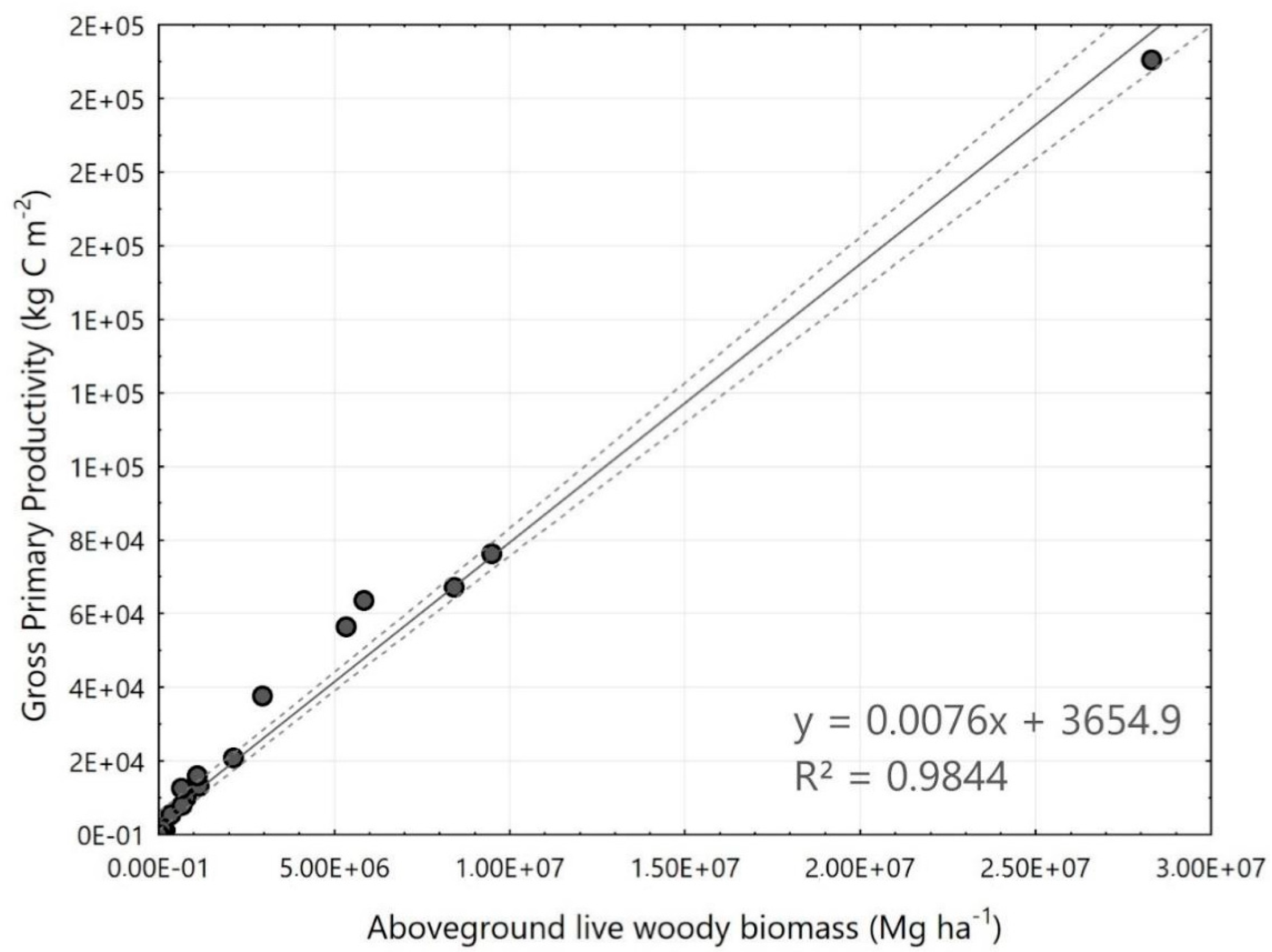
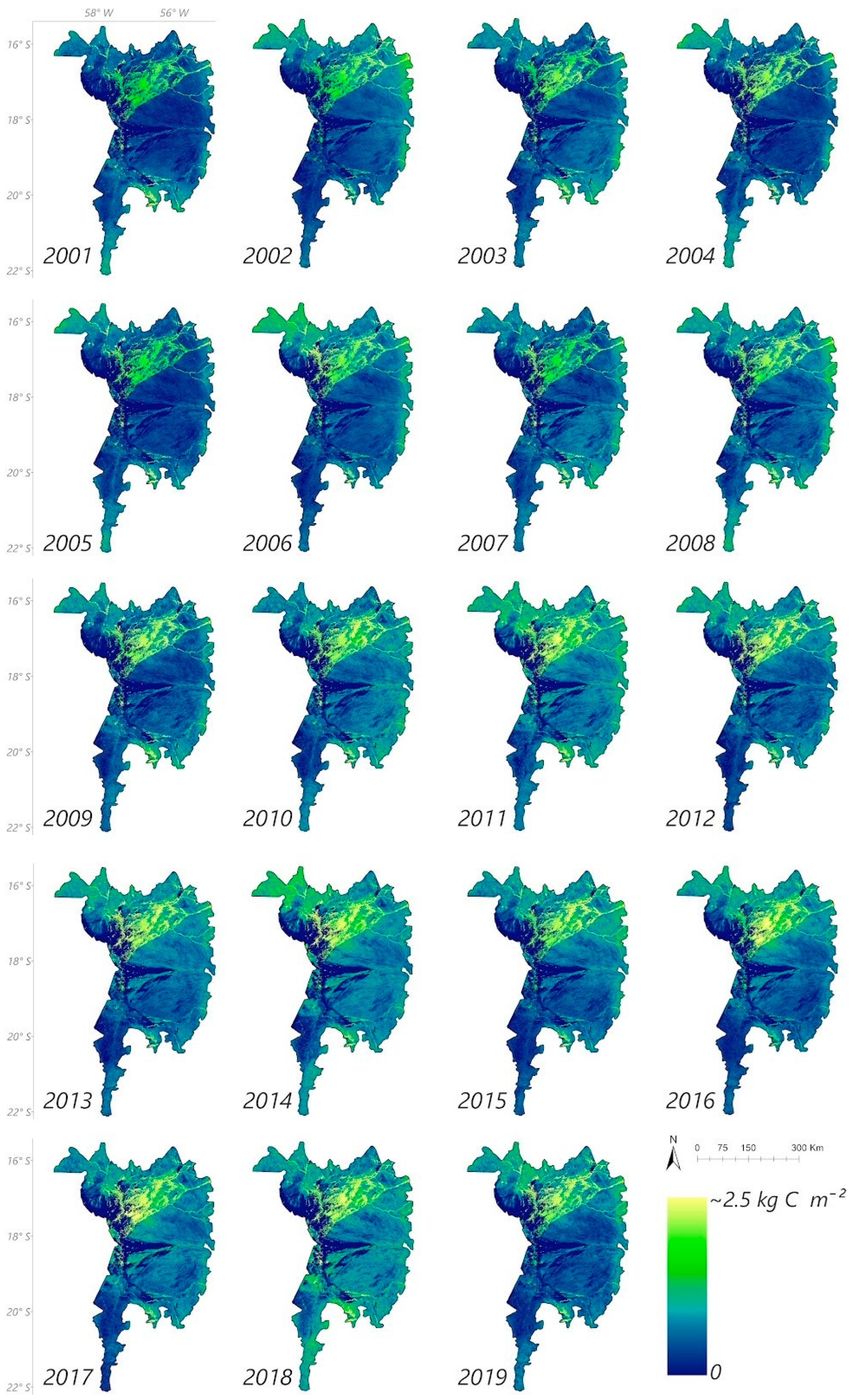
2.3. Gross Primary Productivity

GPP (Gross Primary Productivity) was used as an available time-series basis to estimate aboveground plant biomass across the Brazilian Pantanal. Aboveground woody biomass density data were obtained for the year 2012 from the “WHRC/biomes/tropical” collection at a spatial resolution of 500 m [35]. This dataset was assembled from co-located field measurements, LiDAR observations, and imagery recorded by MODIS sensor.
The 500 m-resolution MOD and MYD17A2 product related to GPP is a cumulative composite of GPP values based on the efficiency of solar radiation use by vegetation (ε). In this logic, primary production is linearly related to absorbed photosynthetically active radiation (APAR), according to Equation (3). APAR can be calculated as the product of the incident photosynthetically active radiation (PAR) in the visible spectral range of 0.4–0.7 μm, assumed to be 45% of the total incident solar radiation, and the fraction of photosynthetically active radiation absorbed by the vegetation cover (FPAR) [36].
G P P = ε × P A R × F P A R
One of the greatest challenges in using these models is obtaining the light use efficiency “ε” over a large area due to its dependence on environmental and vegetation factors. A solution is to relate “ε” according to its maximum value (εmax) plus the environmental contributions synthesized by the minimum air temperature (Tminscalar) and the water status of the vegetation (VPDscalar—water vapor pressure deficit) [37], according to Equation (4).
ε = ε m a x × T m i n s c a l a r × V P D s c a l a r
In this study, we used MODIS GPP version 5.0 from 2001 to 2019. Pixel values referring to the digital numbers of MODIS images were converted into biophysical values (Kg C m−2) by multiplying by a 0.0001 scale factor [36]. GPP values were also transformed to the cumulative values for each year of the time series.

2.4. Counts of Fire Foci

Monthly data on fire foci were acquired between 2001 and 2019. Fire foci data were calculated using the Moderate Resolution Imaging Spectroradiometer of the MODIS sensor TERRA/AQUA. We used near real-time (NRT) MODIS Thermal Anomalies/Fire locations (Collection 6) processed by NASA’s Land, Atmosphere Near real-time Capability for EOS (LANCE) Fire Information for Resource Management System (FIRMS), using swath products (MOD14/MYD14) rather than the tiled MOD14A1 and MYD14A1 products. The thermal anomalies/active fires represent the center of a 1 km pixel flagged by the MODIS MOD14/MYD14 Fire and Thermal Anomalies algorithm [38] as containing one or more fires within that pixel. This characteristic is the most basic fire product in which active fires and other thermal anomalies, such as volcanoes, can be identified. Data were downloaded directly from FIRMS (https://firms.modaps.eosdis.nasa.gov/, accessed on 27 July 2022) and arranged as a shapefile (https://earthdata.nasa.gov/active-fire-data, accessed on 27 July 2022). The FIRMS Fire Map allows users to interactively browse the entire global archive of active fire detections from MODIS and VIIRS. Near real-time fire data are available within approximately 3 h of satellite overpass and imagery within 4–5 h. The final database consisted of a file of fire_archive_M6 = MODIS standard quality Thermal Anomalies/Fire locations processed by the University of Maryland with a 3-month lag and distributed by FIRMS for the years 2001 to 2019.

2.5. Statistical Analysis
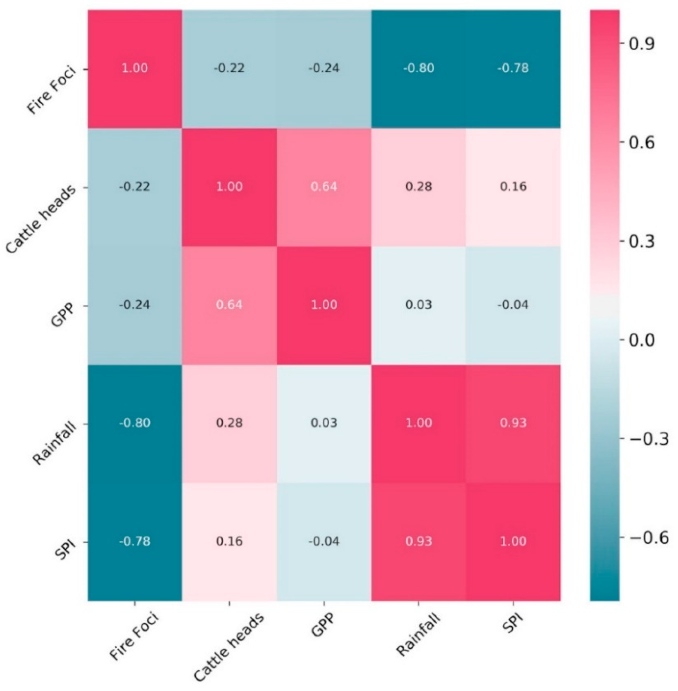
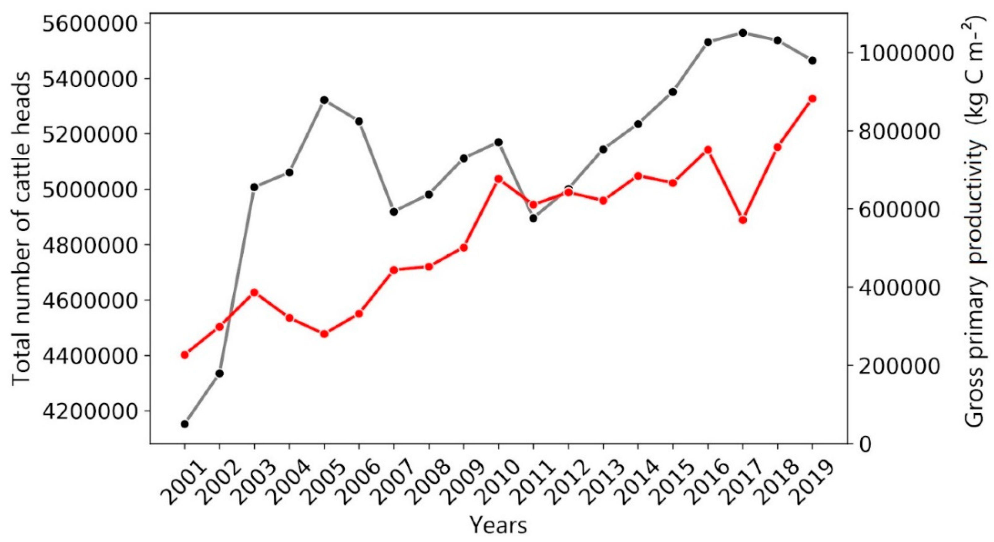
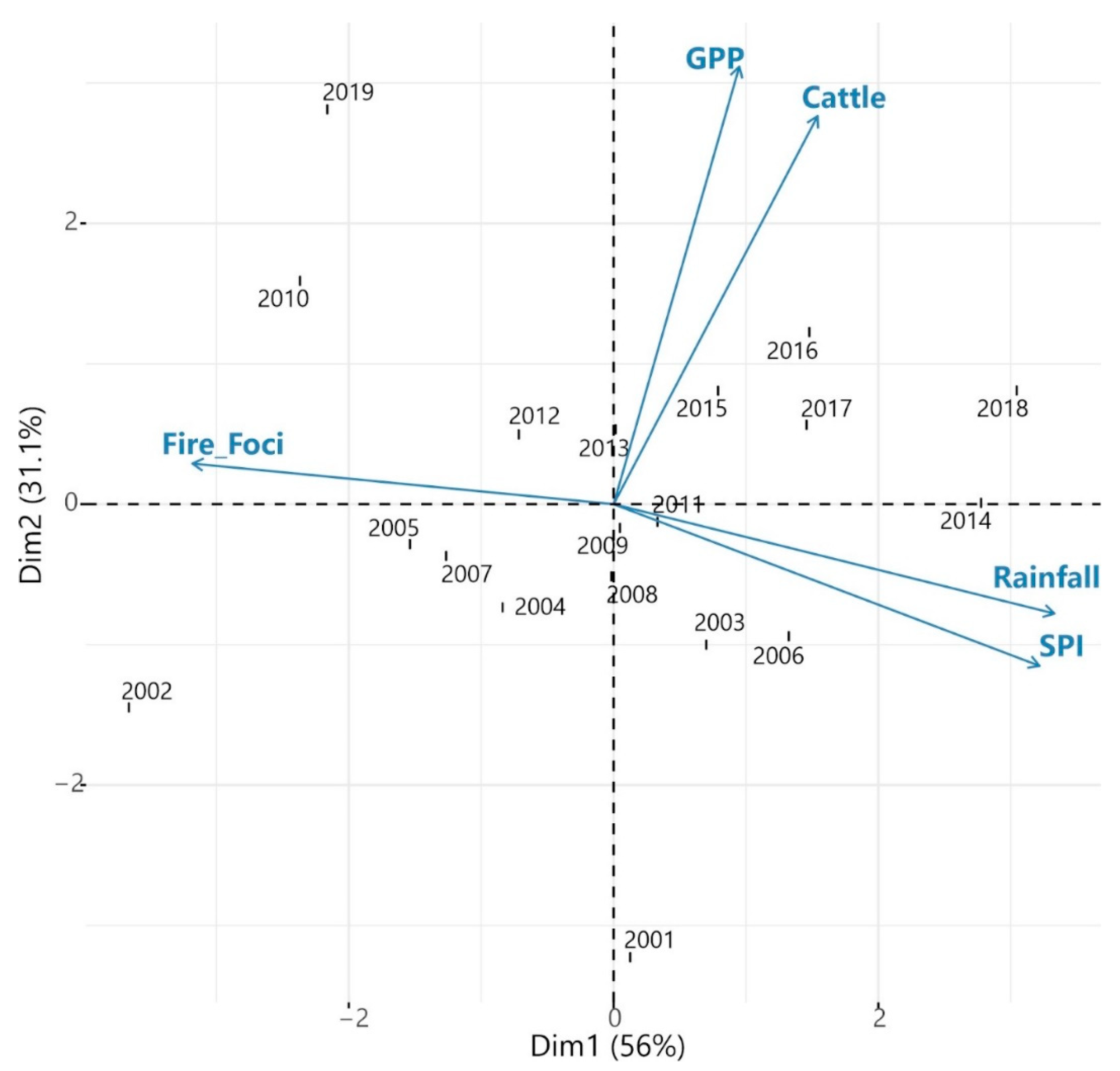
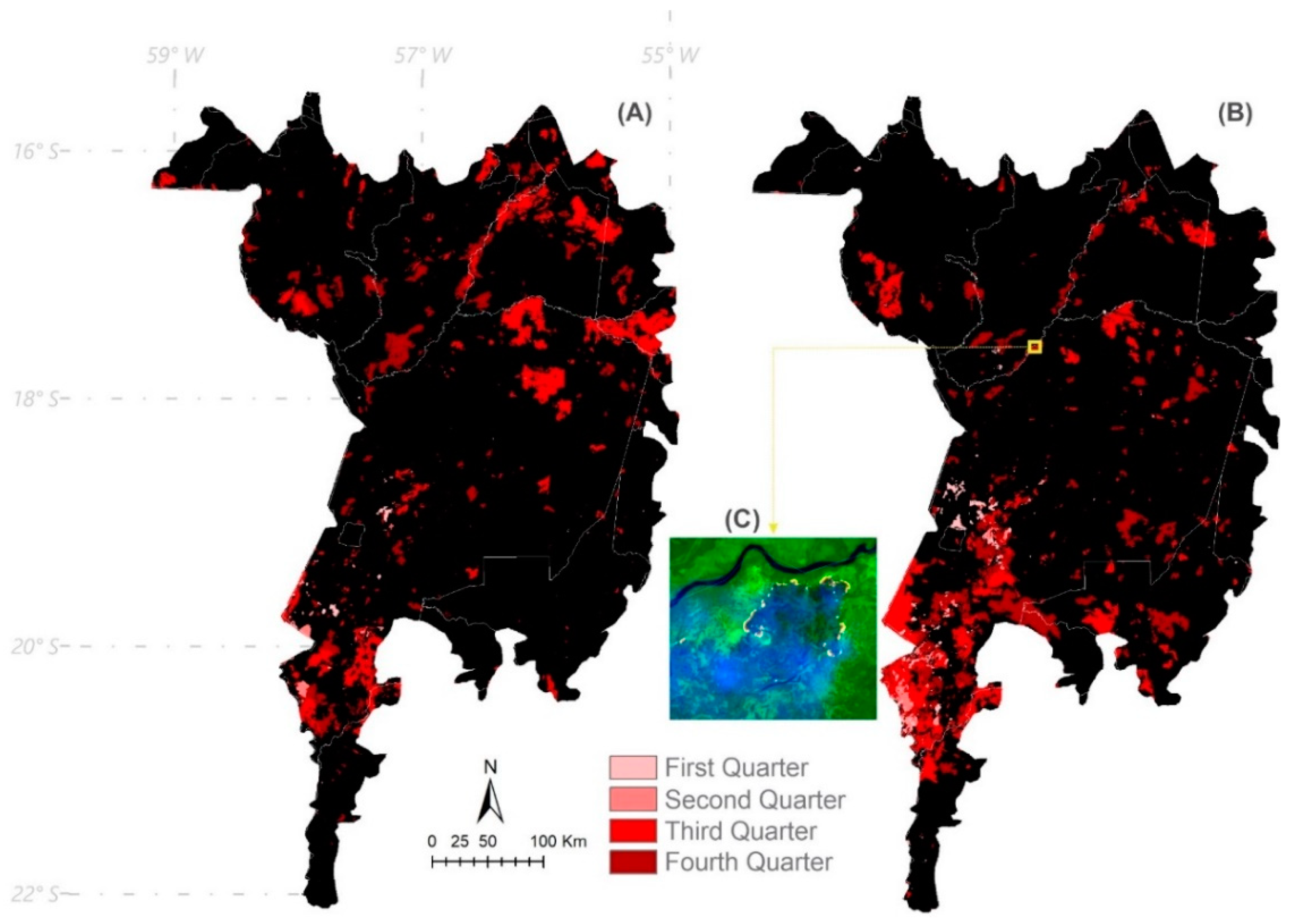
Initially, we plotted Standardized Precipitation Index (SPI) × count of fire foci, gross primary productivity × aboveground live woody biomass, and total number of cattle heads × gross primary productivity to examine the dispersion of these variables over the time series and their Pearson’s correlation values. The Mann–Kendall test was applied to examine variable trends over the time series, followed by the Pettitt test to identify the likely point of change when the trend became significant. In all cases, a 5% probability level was adopted for statistical tests. Subsequently, a principal component analysis (PCA) was performed to interrelate all years and variables. All analyses were performed using the R environment, supported by the packages “ggplot2”, “trend”, “MannKendall”, and “factoextra”.

3. Results

This section may be divided by subheadings and should provide a concise and precise description of the experimental results, their interpretation, as well as the experimental conclusions that can be drawn.
The biome-wide SPI time series shows that the years experiencing the most prolonged droughts were 2002, 2010, and 2019. SPI was highly variable among areas affected by drought and the years of occurrence, with the highest values being found for the southern, northeastern, and central regions of the Pantanal in 2002, 2010, and 2019, respectively (Figure 3). Consequently, the years 2014 and 2018 showed the lowest SPI values. When SPI values were highly positive, there was a lower incidence of fires. This is consistent with the lowest numbers of fire foci being found for particularly wet years (2014 and 2018; Figure 4).
Fire foci were inversely related to rainfall. For example, the two wettest years (2014 and 2018) experienced the lowest numbers of fires, which was further supported by a negative correlation between Fire Foci and rainfall (r = −0.80; Figure 5). GPP explained 98% of the variation in aboveground live woody biomass (Figure 6). This relationship can provide an accurate biomass estimate with GPP data over a long time series, made necessary by the absence of LiDAR biomass data [35].
The GPP longitudinal data showed increasing monotonic behaviour, the highest value being attained in 2019 (Figure 7). However, there was only a weak correlation between GPP and fire incidence (r = –0.24) over the time series examined here (Figure 5).
From 2002 onwards, cattle numbers in the Pantanal began to grow until 2005. The overall size of cattle herds increased by 33% over the time series, presenting a positive trend in relation to GPP, which also increased by ~260% from 2001 to 2019 (Figure 8).
A correlation heatmap was generated to demonstrate the dispersion and the relationship between the variables assessed over the time series (Figure 5). Fire incidence was, again, negatively correlated with rainfall and SPI (r = 0.93), whereas GPP was positively correlated with cattle density (r = 0.64).
The results of the trend tests are shown in Table 1. Fire foci, rainfall, and SPI showed neither a positive nor a negative significant trend (p-value > 0.05) over the entire time series. However, the number of head of beef cattle and GPP were positively correlated and showed a significant upward trend (p-value < 0.05), with likely inflection points along the time series in 2012 and 2009, respectively (Figure 5 and Figure 8).
Figure 9 contains the PCA dimensions for the variables assessed over the time series. In agreement with the Pearson correlations, it can be seen that the cattle and GPP vectors converge onto the same quadrants; this is also the case for the rainfall and SPI vectors. Our measure of fire incidence is, however, located in a different quadrant due to its low and/or negative correlation with the other variables. In this biplot, we highlight the proximity between fire foci and particularly dry years, such as 2002, 2010, and 2019, in which the largest burnt areas were recorded. Accordingly, this is consistent with the spatial distribution of fires across the Brazilian Pantanal in 2010 and 2019 (Figure 10). In both of these years, the highest number of fire foci was detected in the southern region of the Pantanal, located in Mato Grosso do Sul and bordering Paraguay.

4. Discussion

Contrary to the hypothesis tested here, our results showed a negative (r = −0.22, Figure 5) rather a than positive relationship between cattle density and the number of fires in the Pantanal over a 19-year time series (Figure 5). This directly contradicts the notion disseminated by Brazil’s current government and the powerful agribusiness sector that rearing of bovine livestock serves to control ecosystem flammability by suppressing grass and shrub biomass, thereby reducing fire intensity and continuity. Were this true, we would expect fewer fire foci in areas occupied by larger numbers of cattle.
The results obtained here show that wildfires in this tropical wetland ecosystem are instead related to weather events, particularly droughts. SPI variation across the Brazilian Pantanal is associated with a higher occurrence of fire outbreaks. During the dry years 2002, 2010, and 2019, when the vegetation was desiccated and fire foci were more frequent and widespread, the correlation between SPI variables and fires was markedly negative (r = −0.78). The same was observed for rainfall correlates of fire foci, which showed an inverse relationship across the entire time series. Those three exceptionally dry years (2002, 2010, and 2019) saw much lower annual rainfall, yielding a strong negative correlation between overall precipitation and fire foci (r = −0.795), while both of these variables showed no correlation with numbers of cattle. This, again, supports the alternative hypothesis that fire incidence and spread are influenced by climatic factors and are most likely unrelated to herbivory pressure exerted by domesticated livestock.
Climate change in the last decade has directly affected the hydrology of the Pantanal biome by reducing precipitation and increasing temperatures [39]. Low rainfall and a temporal shift of the wet season have been observed in the southern Amazon and the Pantanal [40]. Climate change models developed by the Intergovernmental Panel on Climate Change (IPCC) predict an increase of 5 °C to 7 °C in mean air temperature by 2100 [41], which, combined with a drier environment, suggests a future scenario in which vegetation flammability could vastly increase across the Pantanal.
The argument for deploying “cattle to fight fires”, as professed in some policy arenas, is not valid, since the main determinants of reduced fire incidence are declining overall precipitation and prolonged droughts. For example, we highlight the severe recent droughts of 2019 and 2020, which severely aggravated the spread of fires in the Pantanal and the Upper Paraguay basin [42]. Therefore, regional scale climate change tends to tip the balance towards drier and hotter episodes, which will likely aggravate the severity of seasonal droughts in years to come [8,11], paving the way for more frequent and more intensive uncontrolled fires with much greater impacts on flora and fauna across the Pantanal ecosystem.
It is important to highlight that dry-season fires (May to September) are almost entirely anthropogenic, since fires are deliberately lit as part of a widely used low-cost method [43,44] to both clear vegetation [42] and renew pastures [8,44,45]. However, uncontrolled wildfires induced by agricultural practices are related to inadequate fire use, which results in severe detrimental consequences for ecosystem integrity [22,46].
In this study, we noted that GPP explained 98% of the variation in woody biomass (Figure 6) and that GPP was negatively correlated with fire incidence (r = −0.235). These findings suggest that fires did not necessarily match the proxied availability of fuel loads, even where plant biomass was elevated (Figure 7), which is again inconsistent with the notion of “cattle firefighting”. Rainfall and SPI also failed to explain GPP increments along the time series. Cattle numbers showed a positive correlation with GPP (Figure 5), which also contradicts the notion that cattle effectively suppress fires, in which case we would expect a negative correlation instead. On the other hand, we highlight that even the most protected areas that are not grazed by cattle can be vulnerable to anthropogenic fires, especially during extreme droughts. Another aggravating factor is that a 260% increase in GPP where fires are most prominent will impact radiative forcing, raising the regional atmospheric temperatures from biomass burning, as pointed out in the latest IPCC AR5 Report [47] and several studies [48,49,50].
Axis 1 of the PCA (Figure 9) explained 56% of the variation in the total variance of the variables evaluated over the time series and revealed two distinct clusters, in which dry years (2002, 2009, and 2019) were strongly correlated with fire incidence, whereas wetter years (2014 and 2018) were correlated with precipitation and SPI. The other years in the time series are apparently uninformative with respect to the variables examined here. Considering axis 2, cattle density and GPP were positively correlated with the year 2019, while the correlation between these variables was negative for 2001. This can be explained because there was considerable growth in cattle numbers and GPP during this period. Although cattle abundance and GPP were positively correlated, they were uncorrelated with fire incidence, SPI, and rainfall.
These results clearly indicate that the number of cattle heads does not directly influence the number of fire foci throughout the Pantanal biome. Therefore, the widely professed argument that cattle serve as a natural “firefighting” agent in the Pantanal wetlands cannot be validated on the basis of available evidence. The Pantanal has been witnessing a gradual decrease in seasonal floodwaters (i.e., total surface water area) which has further exposed dry areas to increasingly severe fire susceptibility [4]. Public policies to prevent wildfires in this region should be implemented on the basis of benign land-use practices that suppress fires, informed by several other adverse effects, including eroding soil fertility, loss of biodiversity, increasing GHG emissions, and economic losses to farmers [51].

5. Conclusions

The magnitude and spatial spread of wildfires throughout the Pantanal biome are unrelated to cattle herd size, thereby clearly refuting the notion that cattle herbivory can somehow suppress fires. Instead, the distribution of fires was clearly related to climatic factors, such as lower overall annual rainfall and more severe annual hydrological deficits. Cattle numbers were also unrelated to a strong proxy of plant biomass. The so-called “firefighting ox”, as a general statement discussed in some policy and academic circles, cannot be validated on the basis of current evidence. Plant primary productivity also failed to support this hypothesis because it was uncorrelated with fire foci, while being strongly correlated with cattle stocking rates. The contemporary spate of wildfires across the Pantanal is driven by a pernicious combination of extreme weather events and inappropriate agricultural practices that are becoming increasingly outdated. The Brazilian government urgently needs to promote and enforce strong public policies to safeguard against fires not only the biodiversity of the Pantanal wetlands but also the natural capital assets that support the regional scale economy. If urgent measures are not taken, the Pantanal will face an uncertain future in Brazil and neighboring countries, with globally significant loss of the natural heritage of a unique biome.

Author Contributions

Conceptualization, P.E.T., C.A.d.S.J., and M.L.; formal analysis, P.E.T., C.A.d.S.J., J.M.A.R., and A.d.A.e.S.; investigation, P.E.T., C.A.d.S.J., M.L., L.d.S.M., M.C.M.d.S., S.S.d.S., F.S.R., L.P.R.T., J.L.D.-S., R.C.D., and C.A.P.; resources, P.E.T., L.P.R.T., and C.A.d.S.J.; data curation, C.A.d.S.J., M.L., F.S.R., and L.d.S.M.; writing—original draft preparation, P.E.T., L.P.R.T., C.A.d.S.J., and M.L.; writing—review and editing, C.A.P., C.A.d.S.J., M.L., and P.E.T.; visualization, L.P.R.T., M.L., C.A.d.S.J., C.A.P., and P.E.T.; supervision, C.A.d.S.J.; project administration, P.E.T., C.A.d.S.J., and M.L. All authors have read and agreed to the published version of the manuscript.

Funding

This research received no external funding.

Institutional Review Board Statement

Not applicable.

Informed Consent Statement

Not applicable.

Data Availability Statement

The datasets used and/or analyzed during the current study are available from the corresponding author upon reasonable request.

Acknowledgments

The authors would like to thank the Universidade Federal de Mato Grosso do Sul (UFMS), Universidade do Estado do Mato Grosso (UNEMAT), Conselho Nacional de Desenvolvimento Científico e Tecnológico (CNPq) (grant numbers: 303767/2020-0 and 309250/2021-8), and the Fundação de Apoio ao Desenvolvimento do Ensino, Ciência e Tecnologia do Estado de Mato Grosso do Sul (FUNDECT) (grant numbers: 88/2021 and 07/2022; SIAFEM numbers: 30478 and 31333). This study was financed in part by the Coordenação de Aperfeiçoamento de Pessoal de Nível Superior—Brazil (CAPES) (financial code: 001).

Conflicts of Interest

The authors declare no conflict of interest. The funders had no role in the study design; in the collection, analyses, or interpretation of data; in the writing of the manuscript; or in the decision to publish the results.

References

  1. Junk, W.J.; Piedade, M.T.F.; Lourival, R.; Wittmann, F.; Kandus, P.; Lacerda, L.D.; Bozelli, R.L.; Esteves, F.A.; da Cunha, C.N.; Maltchik, L.; et al. Brazilian wetlands: Their definition, delineation, and classification for research, sustainable management, and protection. Aquat. Conserv. Mar. Freshw. Ecosyst. 2013, 24, 5–22. [Google Scholar] [CrossRef]
  2. da Cunha, C.N.; Junk, W.J.; Leitão-Filho, H.F. Woody Vegetation in the Pantanal of Mato Grosso, Brazil: A preliminary typology. Amazoniana 2007, 19, 159–184. [Google Scholar]
  3. Mega, E.R. ‘Apocalyptic’ fires are ravaging the world’s largest tropical wetland. Nature 2020, 586, 20–21. [Google Scholar] [CrossRef] [PubMed]
  4. Tomas, W.M.; Berlinck, C.N.; Chiaravalloti, R.M.; Faggioni, G.P.; Strüssmann, C.; Libonati, R.; Abrahão, C.R.; do Valle Alvarenga, G.; de Faria Bacellar, A.E.; de Queiroz Batista, F.R.; et al. Distance sampling surveys reveal 17 million vertebrates directly killed by the 2020′s wildfires in the Pantanal, Brazil. Sci. Rep. 2021, 11, 23547. [Google Scholar] [CrossRef] [PubMed]
  5. INPE Programa Queimadas. Available online: http://queimadas.dgi.inpe.br/queimadas/portal-static/situacao-atual/ (accessed on 12 December 2020).
  6. Kumar, S.; Getirana, A.; Libonati, R.; Hain, C.; Mahanama, S.; Andela, N. Changes in land use enhance the sensitivity of tropical ecosystems to fire-climate extremes. Sci. Rep. 2022, 12, 964. [Google Scholar] [CrossRef]
  7. de Oliveira-Júnior, J.F.; Teodoro, P.E.; da Silva Junior, C.A.; Baio, F.H.R.; Gava, R.; Capristo-Silva, G.F.; de Gois, G.; Correia Filho, W.L.F.; Lima, M.; de Barros Santiago, D.; et al. Fire foci related to rainfall and biomes of the state of Mato Grosso do Sul, Brazil. Agric. For. Meteorol. 2020, 282–283, 107861. [Google Scholar] [CrossRef]
  8. Bergier, I.; Silva, A.P.S.; de Abreu, U.G.P.; de Oliveira, L.O.F.; Tomazi, M.; Dias, F.R.T.; Urbanetz, C.; Nogueira, É.; Borges-Silva, J.C. Could bovine livestock intensification in Pantanal be neutral regarding enteric methane emissions? Sci. Total Environ. 2019, 655, 463–472. [Google Scholar] [CrossRef]
  9. Marengo, J.A.; Oliveira, G.S.; Alves, L.M. Climate Change Scenarios in the Pantanal. In Dynamics of the Pantanal Wetland in South America; Bergier, I., Assine, M.L., Eds.; Springer International Publishing: Rio Claro, Brazil, 2016; pp. 227–238. [Google Scholar]
  10. Manrique-Pineda, D.A.; de Souza, E.B.; Paranhos Filho, A.C.; Cáceres Encina, C.C.; Damasceno-Junior, G.A. Fire, flood and monodominance of Tabebuia aurea in Pantanal. For. Ecol. Manag. 2021, 479, 118599. [Google Scholar] [CrossRef]
  11. Li, X.; Song, K.; Liu, G. Wetland Fire Scar Monitoring and Its Response to Changes of the Pantanal Wetland. Sensors 2020, 20, 4268. [Google Scholar] [CrossRef]
  12. Arruda, W.D.S.; Oldeland, J.; Paranhos Filho, A.C.; Pott, A.; Cunha, N.L.; Ishii, I.H.; Damasceno-Junior, G.A. Inundation and Fire Shape the Structure of Riparian Forests in the Pantanal, Brazil. PLoS ONE 2016, 11, e0156825. [Google Scholar] [CrossRef]
  13. Gitas, I.Z.; Mitri, G.H.; Ventura, G. Object-based image classification for burned area mapping of Creus Cape, Spain, using NOAA-AVHRR imagery. Remote Sens. Environ. 2004, 92, 409–413. [Google Scholar] [CrossRef]
  14. Machado, R.X.; Costa, E.A. O turismo de pesca em Corumbá, na fronteira Oeste do Brasil. Rev. Iberoam. Tur. 2017, 7, 36–48. [Google Scholar] [CrossRef]
  15. Soriano, B.M.A.; Narciso, M.G. Sistema de alerta de risco de incêndio para o Pantanal. In O Meio Ambiente e a Interface dos Sistemas Social e Natural; Silva, M.E.D., Ed.; Atena Editora: Ponta Grossa, Brazil, 2020; pp. 95–103. ISBN 978-65-5706-268-5. [Google Scholar]
  16. IBGE Pesquisa da Pecuária Municipal. Available online: https://sidra.ibge.gov.br/tabela/3939 (accessed on 27 July 2022).
  17. da Silva Junior, C.A.; Teodoro, P.E.; Delgado, R.C.; Teodoro, L.P.R.; Lima, M.; de Andréa Pantaleão, A.; Baio, F.H.R.; de Azevedo, G.B.; de Oliveira Sousa Azevedo, G.T.; Capristo-Silva, G.F.; et al. Persistent fire foci in all biomes undermine the Paris Agreement in Brazil. Sci. Rep. 2020, 10, 16246. [Google Scholar] [CrossRef]
  18. Tomas, W.M.; de Oliveira Roque, F.; Morato, R.G.; Medici, P.E.; Chiaravalloti, R.M.; Tortato, F.R.; Penha, J.M.F.; Izzo, T.J.; Garcia, L.C.; Lourival, R.F.F.; et al. Sustainability Agenda for the Pantanal Wetland: Perspectives on a Collaborative Interface for Science, Policy, and Decision-Making. Trop. Conserv. Sci. 2019, 12, 1940082919872634. [Google Scholar] [CrossRef]
  19. da Silva Junior, C.A.; Lima, M.; Teodoro, P.E.; de Oliveira-Júnior, J.F.; Rossi, F.S.; Funatsu, B.M.; Butturi, W.; Lourençoni, T.; Kraeski, A.; Pelissari, T.D.; et al. Fires Drive Long-Term Environmental Degradation in the Amazon Basin. Remote Sens. 2022, 14, 338. [Google Scholar] [CrossRef]
  20. Pivello, V.R.; Vieira, I.; Christianini, A.V.; Ribeiro, D.B.; da Silva Menezes, L.; Berlinck, C.N.; Melo, F.P.L.; Marengo, J.A.; Tornquist, C.G.; Tomas, W.M.; et al. Understanding Brazil’s catastrophic fires: Causes, consequences and policy needed to prevent future tragedies. Perspect. Ecol. Conserv. 2021, 19, 233–255. [Google Scholar] [CrossRef]
  21. Fernández-Guisuraga, J.M.; Suárez-Seoane, S.; Fernandes, P.M.; Fernández-García, V.; Fernández-Manso, A.; Quintano, C.; Calvo, L. Pre-fire aboveground biomass, estimated from LiDAR, spectral and field inventory data, as a major driver of burn severity in maritime pine (Pinus pinaster) ecosystems. For. Ecosyst. 2022, 9, 100022. [Google Scholar] [CrossRef]
  22. Alho, C.J.R.; Mamede, S.B.; Benites, M.; Andrade, B.S.; Sepúlveda, J.J.O. Threats to the Biodiversity of the Brazilian Pantanal due to land use and occupation. Ambiente Soc. 2019, 22. [Google Scholar] [CrossRef]
  23. Wang, J.; Xiao, X.; Bajgain, R.; Starks, P.; Steiner, J.; Doughty, R.B.; Chang, Q. Estimating leaf area index and aboveground biomass of Grazing pastures using Sentinel-1, Sentinel-2 and Landsat images. ISPRS J. Photogramm. Remote Sens. 2019, 154, 189–201. [Google Scholar] [CrossRef]
  24. Keenan, T.F.; Luo, X.; De Kauwe, M.G.; Medlyn, B.E.; Prentice, I.C.; Stocker, B.D.; Smith, N.G.; Terrer, C.; Wang, H.; Zhang, Y.; et al. Retracted Article: A constraint on historic growth in global photosynthesis due to increasing CO2. Nature 2021, 600, 253–258. [Google Scholar] [CrossRef]
  25. Demattê, J.A.M.; Horák-Terra, I.; Beirigo, R.M.; da Silva Terra, F.; Marques, K.P.P.; Fongaro, C.T.; Silva, A.C.; Vidal-Torrado, P. Genesis and properties of wetland soils by VIS-NIR-SWIR as a technique for environmental monitoring. J. Environ. Manag. 2017, 197, 50–62. [Google Scholar] [CrossRef] [PubMed]
  26. Alvares, C.A.; Stape, J.L.; Sentelhas, P.C.; Gonçalves, J.D.M.; Sparovek, G. Köppen’s climate classification map for Brazil. Meteorol. Z. 2013, 22, 711–728. [Google Scholar] [CrossRef]
  27. de Morais Danelichen, V.H.; Biudes, M.S. Biophysical parameters analysis in the detection of coverage changes and land use in a conservation unit in the Brazilian Pantanal. Rev. Ibero-Am. Ciências Ambient. 2020, 11, 664–676. [Google Scholar] [CrossRef]
  28. Diretoria de Geociências do IBGE (Ed.) IBGE Manual Técnico de Pedologia, 2nd ed.; IBGE: Rio de Janeiro, Brazil, 2007; ISBN 978-85-240-3722-9. [Google Scholar]
  29. McKee, T.B.; Doesken, N.J.; Kleist, J. The relationship of drought frequency and duration to time scales. In Proceedings of the 8th Conference on Applied Climatology, Anaheim, CA, USA, 17–22 January 1993; Volume 17, pp. 179–183. [Google Scholar]
  30. Gois, G. Caracterização da Seca e Seus Efeitos na Produção da Cultura do Milho Para as Diferentes Regiões do Estado de Minas Gerais. Master’s Thesis, Universidade Federal de Viçosa, Viçosa, Brazil, 2005. [Google Scholar]
  31. Knapp, K.R.; Ansari, S.; Bain, C.L.; Bourassa, M.A.; Dickinson, M.J.; Funk, C.; Helms, C.N.; Hennon, C.C.; Holmes, C.D.; Huffman, G.J.; et al. Globally Gridded Satellite Observations for Climate Studies. Bull. Am. Meteorol. Soc. 2011, 92, 893–907. [Google Scholar] [CrossRef]
  32. Saha, S.; Moorthi, S.; Pan, H.L.; Wu, X.; Wang, J.; Nadiga, S.; Tripp, P.; Kistler, R.; Woollen, J.; Behringer, D.; et al. The NCEP climate forecast system reanalysis. Bull. Am. Meteorol. Soc. 2010, 91, 1015–1057. [Google Scholar] [CrossRef]
  33. Toté, C.; Patricio, D.; Boogaard, H.; van der Wijngaart, R.; Tarnavsky, E.; Funk, C. Evaluation of satellite rainfall estimates for drought and flood monitoring in Mozambique. Remote Sens. 2015, 7, 1758–1776. [Google Scholar] [CrossRef]
  34. Funk, C.C.; Peterson, P.J.; Landsfeld, M.F.; Pedreros, D.H.; Verdin, J.P.; Rowland, J.D.; Romero, B.E.; Husak, G.J.; Michaelsen, J.C.; Verdin, A.P. A quasi-global precipitation time series for drought monitoring. US Geol. Surv. Data Ser. 2014, 832, 1–12. [Google Scholar]
  35. Baccini, A.; Goetz, S.J.; Walker, W.S.; Laporte, N.T.; Sun, M.; Sulla-Menashe, D.; Hackler, J.; Beck, P.S.A.; Dubayah, R.; Friedl, M.A.; et al. Estimated carbon dioxide emissions from tropical deforestation improved by carbon-density maps. Nat. Clim. Chang. 2012, 2, 182–185. [Google Scholar] [CrossRef]
  36. Heinsch, F.A.; Reeves, M.; Votava, P.; Kang, S.; Milesi, C.; Zhao, M.; Glassy, J.; Jolly, W.M.; Loehman, R.; Bowker, C.F.; et al. GPP and NPP (MOD17A2/A3) Products NASA MODIS Land Algorithm. In MOD17 User’s Guide; 2003; pp. 1–57. Available online: https://lpdaac.usgs.gov/documents/212/mod17_v5_user_guide.pdf (accessed on 27 July 2022).
  37. Field, C.B.; Randerson, J.T.; Malmström, C.M. Global net primary production: Combining ecology and remote sensing. Remote Sens. Environ. 1995, 51, 74–88. [Google Scholar] [CrossRef]
  38. Giglio, L.; Schroeder, W.; Justice, C.O. The collection 6 MODIS active fire detection algorithm and fire products. Remote Sens. Environ. 2016, 178, 31–41. [Google Scholar] [CrossRef]
  39. Lázaro, W.L.; Oliveira-Júnior, E.S.; da Silva, C.J.; Castrillon, S.K.I.; Muniz, C.C. Climate change reflected in one of the largest wetlands in the world: An overview of the Northern Pantanal water regime. Acta Limnol. Bras. 2020, 32. [Google Scholar] [CrossRef]
  40. Debortoli, N.S.; Dubreuil, V.; Hirota, M.; Filho, S.R.; Lindoso, D.P.; Nabucet, J. Detecting deforestation impacts in Southern Amazonia rainfall using rain gauges. Int. J. Climatol. 2016, 37, 2889–2900. [Google Scholar] [CrossRef]
  41. Marengo, J.A.; Bernasconi, M. Regional differences in aridity/drought conditions over Northeast Brazil: Present state and future projections. Clim. Chang. 2015, 129, 103–115. [Google Scholar] [CrossRef]
  42. Marengo, J.A.; Cunha, A.P.; Cuartas, L.A.; Deusdará Leal, K.R.; Broedel, E.; Seluchi, M.E.; Michelin, C.M.; De Praga Baião, C.F.; Chuchón Ângulo, E.; Almeida, E.K.; et al. Extreme Drought in the Brazilian Pantanal in 2019–2020: Characterization, Causes, and Impacts. Front. Water 2021, 3, 639204. [Google Scholar] [CrossRef]
  43. Silio-Calzada, A.; Barquín, J.; Huszar, V.L.M.; Mazzeo, N.; Méndez, F.; Álvarez-Martínez, J.M. Long-term dynamics of a floodplain shallow lake in the Pantanal wetland: Is it all about climate? Sci. Total Environ. 2017, 605–606, 527–540. [Google Scholar] [CrossRef]
  44. Schulz, C.; Whitney, B.S.; Rossetto, O.C.; Neves, D.M.; Crabb, L.; de Oliveira, E.C.; Terra Lima, P.L.; Afzal, M.; Laing, A.F.; de Souza Fernandes, L.C.; et al. Physical, ecological and human dimensions of environmental change in Brazil’s Pantanal wetland: Synthesis and research agenda. Sci. Total Environ. 2019, 687, 1011–1027. [Google Scholar] [CrossRef]
  45. Evans, T.L.; Costa, M.; Tomas, W.M.; Camilo, A.R. Large-scale habitat mapping of the Brazilian Pantanal wetland: A synthetic aperture radar approach. Remote Sens. Environ. 2014, 155, 89–108. [Google Scholar] [CrossRef]
  46. Aragão, L.E.O.C.; Anderson, L.O.; Fonseca, M.G.; Rosan, T.M.; Vedovato, L.B.; Wagner, F.H.; Silva, C.V.J.; Silva Junior, C.H.L.; Arai, E.; Aguiar, A.P.; et al. 21st Century drought-related fires counteract the decline of Amazon deforestation carbon emissions. Nat. Commun. 2018, 9, 536. [Google Scholar] [CrossRef]
  47. IPCC (Intergovernmental Panel on Climate Change). Climate Change 2014: Mitigation of Climate Change; Cambridge University Press: Cambridge, UK, 2014; ISBN 9781107058217. [Google Scholar]
  48. Hodnebrog, Ø.; Myhre, G.; Kramer, R.J.; Shine, K.P.; Andrews, T.; Faluvegi, G.; Kasoar, M.; Kirkevåg, A.; Lamarque, J.-F.; Mülmenstädt, J.; et al. The effect of rapid adjustments to halocarbons and N2O on radiative forcing. Npj Clim. Atmos. Sci. 2020, 3, 43. [Google Scholar] [CrossRef]
  49. Goodwin, P. On the Time Evolution of Climate Sensitivity and Future Warming. Earth’s Future 2018, 6, 1336–1348. [Google Scholar] [CrossRef]
  50. Takemura, T. Return to different climate states by reducing sulphate aerosols under future CO2 concentrations. Sci. Rep. 2020, 10, 21748. [Google Scholar] [CrossRef] [PubMed]
  51. Jiménez-Morillo, N.T.; Almendros, G.; De la Rosa, J.M.; Jordán, A.; Zavala, L.M.; Granged, A.J.P.; González-Pérez, J.A. Effect of a wildfire and of post-fire restoration actions in the organic matter structure in soil fractions. Sci. Total Environ. 2020, 728, 138715. [Google Scholar] [CrossRef] [PubMed]
Figure 1. Location of the study area focusing on the Brazilian Pantanal biome. Live woody above-ground biomass is expressed in Mg per hectare of data available from the Google Earth Engine platform (Google, https://earthengine.google.com/, accessed on 27 July 2022) through the dataset available at ee.Image (“WHRC/biomass/tropical”).
Sustainability 14 10187 g001
Figure 2. Supra-annual variation in precipitation and temperature across the Pantanal biome over the time series examined in this study. Blue bars and the black solid line indicate rainfall and temperature, respectively.
Sustainability 14 10187 g002
Figure 3. Standardized Precipitation Index (SPI) across the Brazilian Pantanal wetlands from 2001 to 2019 based on CHIRPS data.
Sustainability 14 10187 g003
Figure 4. Relationship between Standardized Precipitation Index (SPI) and counts of fire foci from 2001 to 2019 across the Brazilian Pantanal. Fire foci and SPI are indicated by the red and grey lines, respectively.
Sustainability 14 10187 g004
Figure 5. Heatmap of Pearson correlation values between fire foci, number of cattle heads, Gross Primary Productivity (GPP), annual precipitation, and SPI from 2001 to 2019 across the Brazilian Pantanal.
Sustainability 14 10187 g005
Figure 6. Linear regression between gross primary productivity and aboveground live woody biomass for the Brazilian Pantanal.
Sustainability 14 10187 g006
Figure 7. Gross Primary Productivity (GPP) from 2001 to 2019 across the Brazilian Pantanal.
Sustainability 14 10187 g007
Figure 8. Relationship between the total beef cattle head and Gross Primary Productivity from 2001 to 2019 across the Brazilian Pantanal. Gross Primary Productivity (GPP) and number of cattle heads are represented by the red and grey lines, respectively.
Sustainability 14 10187 g008
Figure 9. Principal component analysis (PCA) for the variables of fire foci, cattle abundance, GPP, rainfall, and SPI, assessed from 2001 to 2019 in the Brazilian Pantanal.
Sustainability 14 10187 g009
Figure 10. Burned areas obtained from MODIS/006/MCD64A1 images throughout the Brazilian Pantanal biome for the years (A) 2010 and (B) 2019. Specific fire spots in real time (C) obtained by the Sentinel-2/MSI (R12G11B2) sensor system.
Sustainability 14 10187 g010
Table 1. P-value of the Mann-Kendall and Pettitt tests for the variables fire foci, cattle heads, gross primary productivity (GPP), rainfall, and SPI evaluated from 2001 to 2019 in the Brazilian Pantanal.
VariableMann-KendallPettittYear
Fire Foci0.330.68-
Cattle heads<0.000.022012
GPP<0.000.002009
Rainfall0.400.40-
SPI0.530.53-
Publisher’s Note: MDPI stays neutral with regard to jurisdictional claims in published maps and institutional affiliations.

