1. Introduction
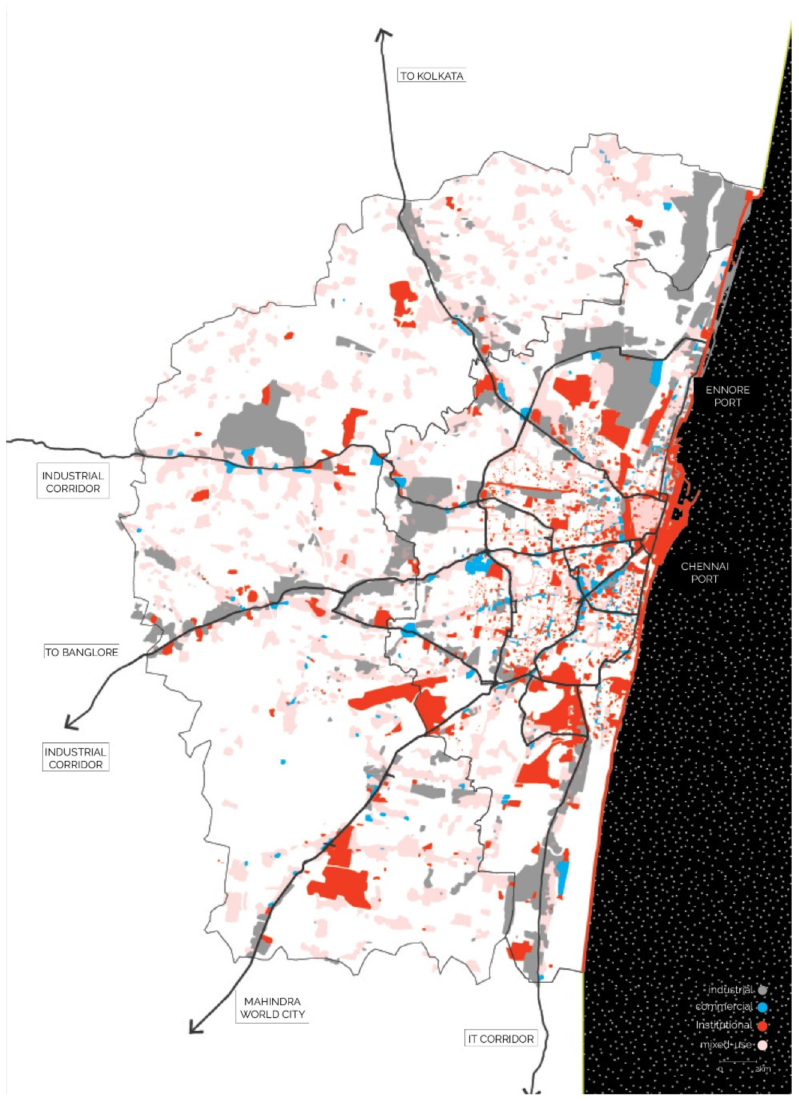
The urban fabric of the southern Indian coastal metropolis of Chennai has undergone extensive transformation over recent decades, particularly since national economic reforms of the 1990s, which have resulted in significant levels of urban expansion in the city and the globalization of its economy [
1]. Rapid urbanization in the city has mainly taken place along the radial infrastructure corridors (
Figure 1) while many other parts of the city have remained relatively underdeveloped [
2]. With almost complete urbanization in the old city core and sprawling growth of the city into its periphery, policy changes were made with respect to building codes and jurisdiction of the city and metropolitan area. This resulted in a significantly expanded boundary for the city and the metropolitan region, leading to the Chennai Metropolitan Area (CMA) being the second largest in India with an area of 8878 sq. km [
2]. The Chennai Metropolitan Development Area (CMDA) has also amended the building codes to allow for a 30% increase in the building density and a relaxation of height restrictions for high-rise development throughout the city.
The pace of urbanization in the city has had multiple impacts on both urban and natural systems, including transport infrastructure and open space. Chennai currently has a very low amount of open space with a ratio of just 0.8 sq. m per person, which stands in stark contrast to the prescribed WHO standard of 9 sq. m per person [
3]. Not only is building density high in Chennai, it also has a very high population density due to the low amount of space that is occupied per person [
4]. This puts increasing pressures on social and mobility infrastructures, which in turn affect livability. Increasing population densities in combination with a high dependency on private motorized vehicles is leading to high levels of transport congestion and pollution in the city. While Chennai has several major modes of public transport—a metro system (which is currently being expanded), a metropolitan elevated railway system (MRTS), a suburban train system, and a bus transit system—analysis shows that following a “business as usual” trajectory may lead to a huge increase in the future share of private vehicular transport [
5]. This has been attributed to the lack of an integrated public transport network, poor last mile connectivity, low levels of walkability, and a lack of multi-modal transport options [
6]. In addition, unchecked urbanization in Chennai has caused the disappearance of large areas of greenspace, including around 70% of wetlands in the city over a period of 30 years, resulting in more serious incidences of flooding and drought [
7]. A large portion of the ecological systems are currently disconnected and inaccessible and often only function as waste dumps, resulting in unhealthy environments with significant ecological repercussions.
The negative externalities of the urbanization processes in Chennai result in feedback loops that further exacerbate the situation. Looking at the proposed policy changes, severe gaps in addressing these issues are apparent. The policy essentially allows the urbanization process to continue as it currently unfolds. A closer examination of regulation changes shows that the increased density of development mainly benefits the real estate sector in the city and, as a result, the target population group to whom they cater. Moreover, densification is considered in a predominantly quantitative way, whereas a qualitative approach is required to ensure that it does not lead to undesirable levels of overcrowding, congestion due to high vehicular traffic, unattractive open space, and ecological deterioration. A critical evaluation of the current situation and the identification of alternate designs and planning approaches for urban development in Chennai is, therefore, required.
Adopting a critical stance on the current planning process in Chennai, this article examines how the city’s ecological systems and public mobility networks can be jointly and effectively employed in the face of continued rapid urbanization, addressing a gap in both practice and theory. The issues with respect to planning and urban development that are highlighted in Chennai can be seen as a general trend across other Indian cities as well, owing to the nature of the planning discipline in India, which has largely been approached as a land-use planning process with tools for development regulation [
8]. This is a top-down model that primarily focuses on economic development [
9], often leading to the exclusion of people’s aspirations and needs [
8], and creating challenges to the integration of qualitative aspects of urban life such as livability into the formal planning process in a meaningful way. The current growth model does not allow for an integrated planning approach to other layers of the urban fabric such as the mobility and ecological systems. As a result, ecological systems are deteriorating in many rapidly urbanizing cities across India, with green cover decreasing [
10].
These points of concern regarding the planning process in Indian cities have been addressed in the recent report on the reforms on urban planning capacities in India, issued by the NITI Aayog [
11], stating the need to evolve from the static masterplan to planning strategies that adapt to social changes that cities are undergoing. Furthermore, the report emphasizes the need to integrate mobility, blue-green infrastructure and the natural environment amongst other urban layers with the land-use plan, with consideration for the creation of people-centric healthy environments.
A key contribution of this article is in setting out an alternative trans-scalar and integrated planning strategy that considers the three concepts of mobility, ecology, and densification in a holistic manner, with the overall goal of achieving improved livability.
A review of the current planning approaches in Indian cities indicates that the planning process is limited to considering no more than one or two different layers or dimensions. For instance, the need to establish a framework for urban ecology in the process of densification has been discussed [
12] and the role of ecology in everyday social life, including benefits for health and well-being has been put forward [
13]. Some Indian cities have also considered how a shift to transit-oriented development might challenge existing planning approaches [
14,
15]. However, attention to multiple layers has been limited to date. This article illustrates how multiple layers might be considered simultaneously by examining how that planning process might integrate considerations about the mobility network, the ecological system, and densification process in order to understand possible synergies and conflicts and their role in daily life patterns and the livability of the city.
In this article, the opportunities for an integrated and trans-scalar design and planning strategy for the city are examined in which livability forms a key objective. The designs and strategies that are contained in this article rest on three concepts: transit-oriented development (TOD), socio-ecological integration, and the two-network strategy. Each of these concepts is described below and contextualized through various methods, broadly classified as theoretical, analytical, and research-by-design. These methods provide insights into historical background, current governing policies, morphological structures, people’s perceptions, daily life patterns, and expert opinions. This allows the definition of the contextual issues and opportunities that are present, as well as a local perspective of the theoretical framework. The study results in an integrated design and planning strategy for Chennai, which largely proposes a redefinition of the mobility system and ecological system in the city, that is mindful of the existing context, allowing for new opportunities in the densification process towards creating a livable public realm. This is further elaborated in the discussion section, in terms of the limitations of the proposed strategy as well as the key points of focus that the current social and governance systems will need to adapt to in order to steer the growth of Chennai in an intentional and integrated manner.
1.1. Theoretical Framework
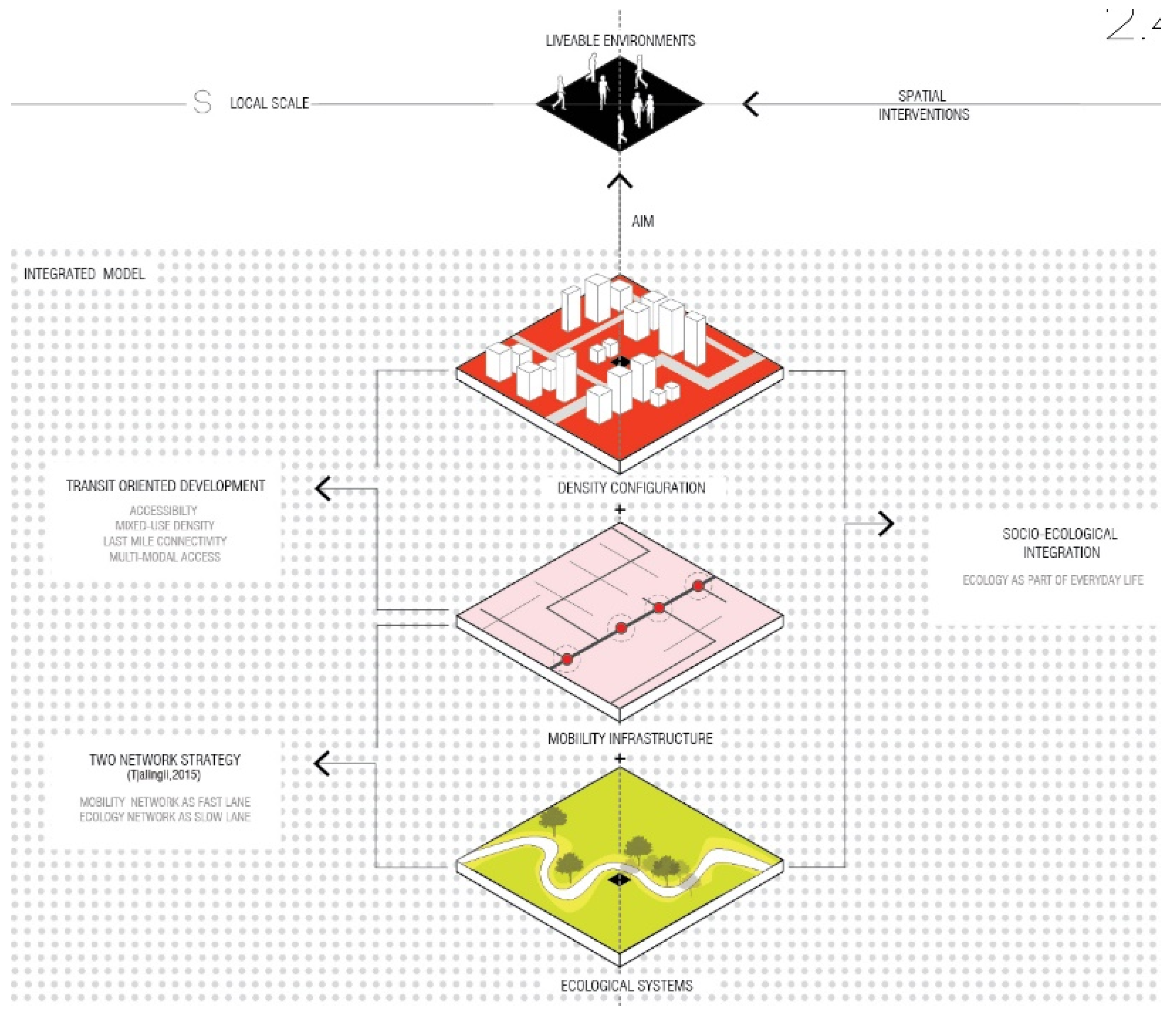
The concepts of livability, the two-network strategy, transit-oriented development (TOD), and social-ecological integration provide the theoretical starting points for the urban designs and planning strategies that are developed in this article (
Figure 2). Underpinning these urban designs and planning strategies is the central aim of facilitating a livable public realm in Chennai. An understanding of the concept of livability and its basic principles was used to determine the spatial goals for the planning framework. The negative externalities of the current processes of urbanization, namely congestion and pollution from high levels of private vehicle use and ecological degradation, are addressed by paying close attention to the provision of a well-connected, low-emission public transport network, and a healthy ecological system in the city. For this reason, the concepts of TOD and socio-ecological integration (SEI) are central. In addition, the two-network strategy (2NS) is employed as a spatial framework to guide the urbanization process. The following sections elaborate these concepts, their relevance to Chennai, and their connection to the chosen strategy.
1.1.1. Livability
The term livability was originally used to describe neighborhood qualities that facilitated spaces that were relatively free of intrusions. This has, however, evolved to include not only traffic management in neighborhoods, but also the qualities that are associated with human life integrated with ecology, personal safety, comfort, accessibility to services, and transit within walking distance [
14]. Livability is a qualitative measure of individual perception rather than a quantitative measure of spatial qualities. It refers to the individual perception of the environment, where people associate certain positive qualities to physical attributes such as traffic, comfort in outdoor space, places to walk, and sound ecology—an integration of human activities with the forces of nature [
14]. The subjective notion of this concept results in indicators of livability being very culturally specific. Therefore, when designing livable environments in Chennai, emphasis must be placed on the Indian and local context, as well as the different lifestyles of the diverse groups of people living in the city.
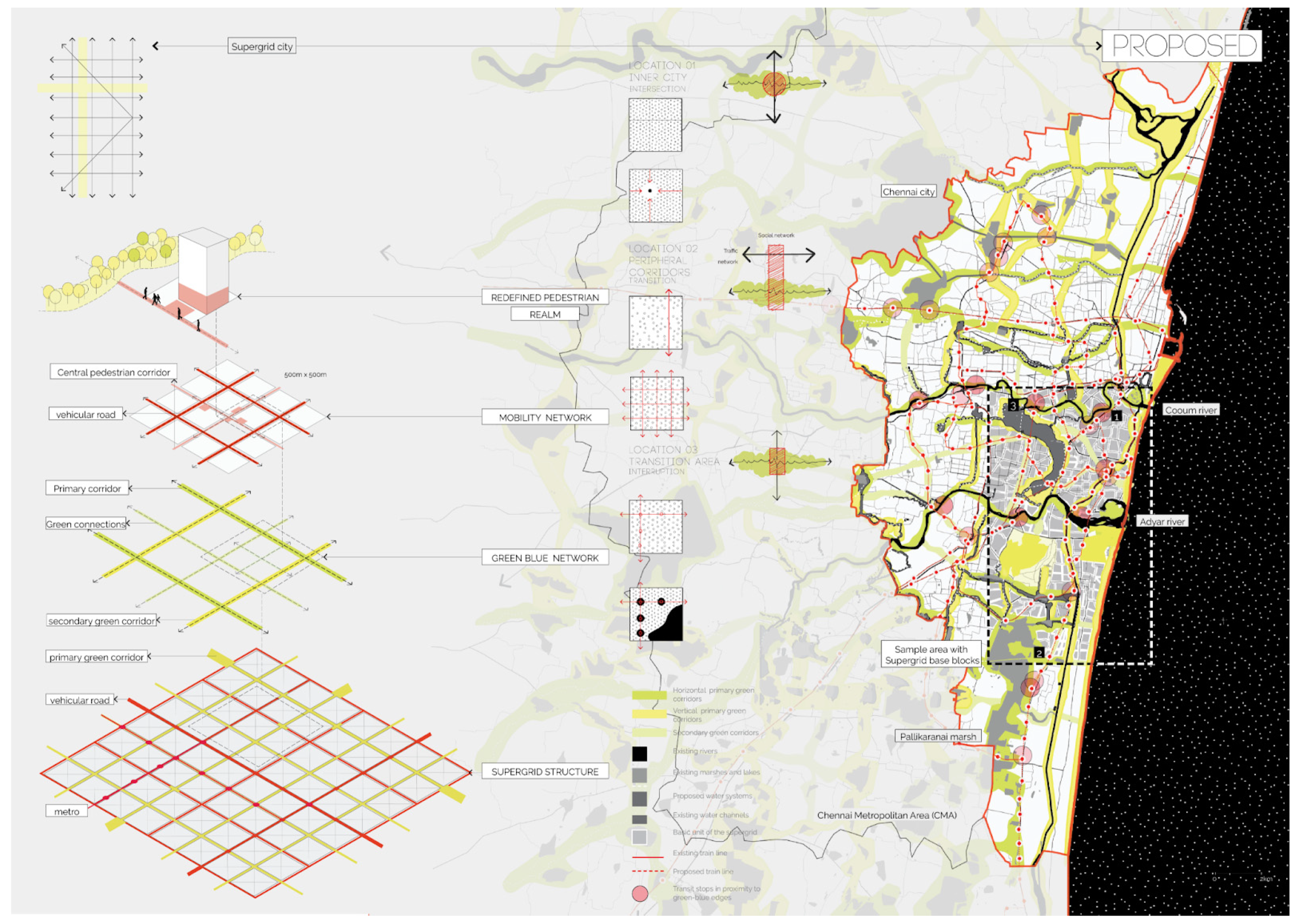
1.1.2. The Two-Network Strategy
The two-network strategy is a design and planning model introduced by Tjallingii who considers ecological and traffic networks as carrying structures of the urbanized landscape, defining a city model based on the relationship between them. The model emphasizes the need to approach ecological networks not as restricting conditions but as carrying structures of growth and activity [
16]. The two networks are evaluated through a common framework of space, in terms of the activities and functions that are facilitated by their configuration and their relationship to each other. The ecological network is described as the “slow lane” which focuses on the long-term benefits for the city in terms of health and well-being. Green open spaces, recreation, and productive landscapes are associated with this network. The traffic network is considered the “fast lane”, which allows for economy-driven development and requires high accessibility. These two networks can be thought of as “cooperative” and “competitive” networks [
16]. The social roles of the two networks also informs the type of stakeholders that will be involved in the different locations. From this perspective, a planning framework is proposed, where the two networks distribute different functions in the city, based on the resources they each require. This allows for a city model that balances economic drivers and ecological systems across the scales of development, while facilitating diverse experiences in everyday life.
1.1.3. Social-Ecological Integration
Social-ecological integration allows for a system to combine social and ecological resources, to alleviate conflicts, and sustain synergies [
17]. Social-ecological integration requires the understanding of the social and ecological systems through the common ground of the spatial system. The spatial system in a city provides the structure to facilitate social processes, and is a manifestation of the same. Ecological processes, when understood similarly, allow the spatial system to become the shared framework for integration [
18]. In the process of socio-ecological integration, synergies and conflicts between ecosystem services and social services are determined in order to identify potentials for urban transformation. Points of synergy, for example, can facilitate city-scale destinations, which translates to a large flow of people to these locations. Points of conflict, for example, might be found at the intersection of the water system and the traffic network, where hydraulic bottlenecks that are created by the latter increase flood risk, decrease ecosystem functions, and create barriers to pedestrian movement. Interventions in points of synergy or conflict are hence strategic in nature.
1.1.4. Transit-Oriented Development
Transit-oriented development (TOD) is defined as “mixed-use communities within an average [2000-foot] walking distance of a transit stop and a core commercial area. TODs mix residential, retail, office, open space, and public uses in a walkable environment, making it convenient for residents and employees to travel by transit, bicycle, foot, or car” [
19]. TOD is also the process of creating dense and diverse areas around public transit stops in order to maximize the use of public transport over private motorized vehicles and promote more walkable streets in the city. The density concentrations in the city are determined by the transit nodes, leading to an urbanization pattern of compact clusters. Further, the transit nodes start gaining a sense of hierarchy in terms of their accessibility and connections. Therefore, multimodal access points become important nodes in the city, ideally providing access to city-scale destinations as well as connections to different modes of transport. This hierarchy can provide a spatial structure to the city, informing the location of city-scale destinations, local commercial functions, and businesses. The activation of transit nodes that already exist can be facilitated by understanding the catchment area for various metropolitan functions in a city [
20]. This process can be used to identify the missing functions around a transit node.
1.1.5. Contextualization
Having defined the theoretical notions of the planning framework, it is important to understand the systems that they represent in the context of Chennai. Infrastructure development and the property market drives much of the growth of Chennai. The negative externalities of a sprawling, developer-driven urbanization pattern has led to an inefficient and unsustainable mobility network and a neglected and polluted ecological network. These conditions, along with the very high population density that is found in the city result in very poor living quality within Chennai, with a severe lack of social spaces that are dedicated to long-term health and well-being, which are important components of livability.
The two-network strategy is a concept that can facilitate the creation of diverse environments within the city, and at the same time, allow for balanced growth as opposed to the purely economy-driven growth that is prevalent today. The “slow lane” can facilitate environments in the city that cater to the long-term well-being and health of the city and its residents in the form of accessible ecological spaces and social spaces. Further, Chennai could benefit from shifting from private motorized vehicles to other modes of transport such as walking and cycling, especially for shorter trips. Evaluating the current condition of the public mobility system in Chennai, through the factors and indicators that are dictated by the theory of TOD will enable a contextual understanding of strategies that can better promote the use of these means of transport over private motorized vehicles. The presence of an ecological network will greatly help these modes of transport, as the green network complements slow modes of traffic very well [
16]. Historically, Chennai possessed a community-driven water management system that has been lost over time. Understanding the nature of this shift in the relationship between the city and ecology, along with the use of the principles of socio-ecological integration will bring forth strategies that can be contextually implemented.
Considering the three theoretical notions holistically, a complex relationship is made explicit between mobility networks, ecological networks, and their impact on building functions and densities. Therefore, while the two-network strategy proposes a method of distributing the slow and fast networks in the city, the concept of TOD and socio-ecological integration inform the distribution of densities, functions, and the concentration and flows of people in the city. This addition is of prime importance in the context of Chennai for two reasons. Firstly, in Chennai, as a result of its high population densities, the impact of the concentration and movement of people has a very large effect on the effective functioning of the two networks. Secondly, with the inner city being densely packed and urbanized and the peripheries quickly growing, transformation of built densities will play a primary role in shaping the two networks themselves.
This approach has the potential to transform the spatial conditions in the city through different means. The primary aim of the transformation is the creation of more accessible green spaces, public places, and livable environments in the city. It promotes a shift towards public transport from private motorized vehicles, allowing the decrease in congestion of roads in the city leading to a better environmental quality and well-being. The inclusion of the ecological systems as part of the accessible urban fabric and a part of daily life patterns adds to the quality of open spaces in the city. Conversely, it also helps to better manage the fragile ecological systems in the city. This integrated theoretical framework is contextualized to Chennai in order to formulate an integrated strategic plan that takes into account local issues as well as local potential characteristics and behavioral patterns.
2. Materials and Methods
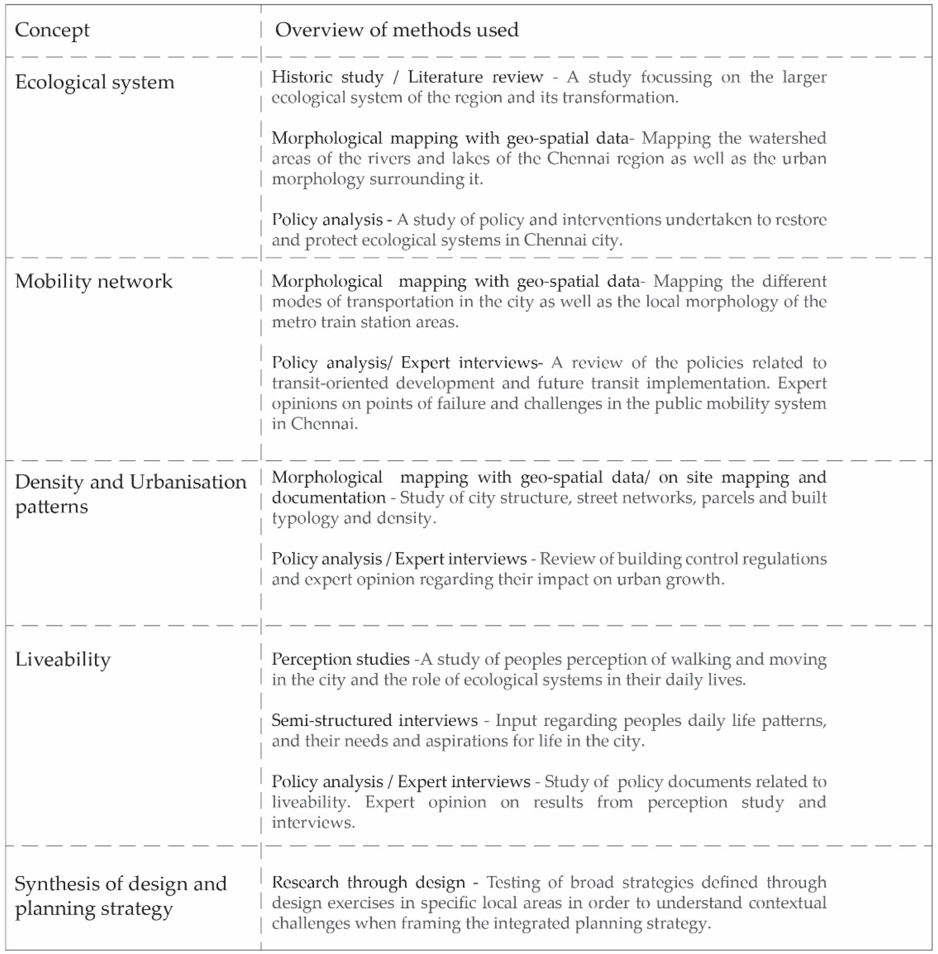
This article considers four main areas of analysis: ecological structures, urban morphology, mobility, and livability (
Figure 3). For an in-depth understanding of the general context, all the areas of analysis involved study of historical documentation, policy documents, and relevant research, which were mapped to understand their spatial implications. The analytical methods largely concern morphological mapping of the urban, ecological, and social structures. An important part of this study relies on empirical evidence that was collected through on-site perception studies, interviews, and expert interviews, which were also mapped and studied in conjunction with the morphological analysis, allowing the qualitative information to be understood in terms of spatial structures. Finally, research-by-design utilized the design process to apply and test theoretical notions in a selection of representative locations in Chennai, to validate and extrapolate larger strategies for the city.
The study of historical documentation, including text and cartographic material, was particularly useful for understanding the larger ecological systems of the region, many of which are not visible anymore. The historical texts and cartographic material provided information from the pre-colonial period, allowing for a good overview of the transformations of the territory from the natural to the urbanized condition. This provided an insight into how the social-ecological relationship that existed in the past had resulted in the creation of an extensive water management system. Further, it also shed light on the reasons for the changing nature of this relationship today, where the ecological structures in the city are degraded and becoming non-existent. Using geospatial data from the Chennai masterplan that was prepared by the CMDA, the watersheds that fall in the region of Chennai were mapped out along with a study of research reports on sample portions of the water system to understand larger ecological boundaries, current ecological issues, and the restoration efforts being undertaken. For example, the executive report regarding the eco-restoration of the Cooum river by the Chennai River Restoration Trust (CRRT) [
21] was studied in order to understand the social and ecological issues that the degrading river faced. Policy documents were studied to understand the current policies and regulations governing densification and proposals for future public transit stops. Future proposals for public transport, specifically metro rail, and the impact on the urbanization pattern as a result was also understood through this process. Further, governance structures and hierarchies in relation to executing these public projects were understood, providing an insight into the implementation of the alternative planning strategy that is proposed.
A study of the road and street networks in the city along with building density, function, and parcel typology allowed for a broad classification of the city in terms of urban typology. This enabled the proposal of strategies that were extrapolated and transferable to each of these categories. A morphological study of the city mapped out the different modes of transportation overlapped with important city functions, destinations, and street networks. This showed different challenges in implementing TOD in the various parts of the city. In local sites, GIS mapping of the network measures such as choice and accessibility from metro stops were used to pinpoint the changes that were required to the street structure to improve walkability. Local morphological structures along with a mapping of the functions and activities were used to understand the flow of people and goods, to better propose restructuring of the city networks. The two networks, namely the ecological systems and the mobility network were mapped together to understand their existing configurations and potentials for intersections, overlaps, and transitions. This allowed for a spatial exploration to understand the different ways in which the slow and fast lanes of the two-network strategy could be contextualized to Chennai. For both street and ecological networks, a combination of OpenStreetMap data, morphological data from the Chennai masterplan, and fieldwork mapping data were used.
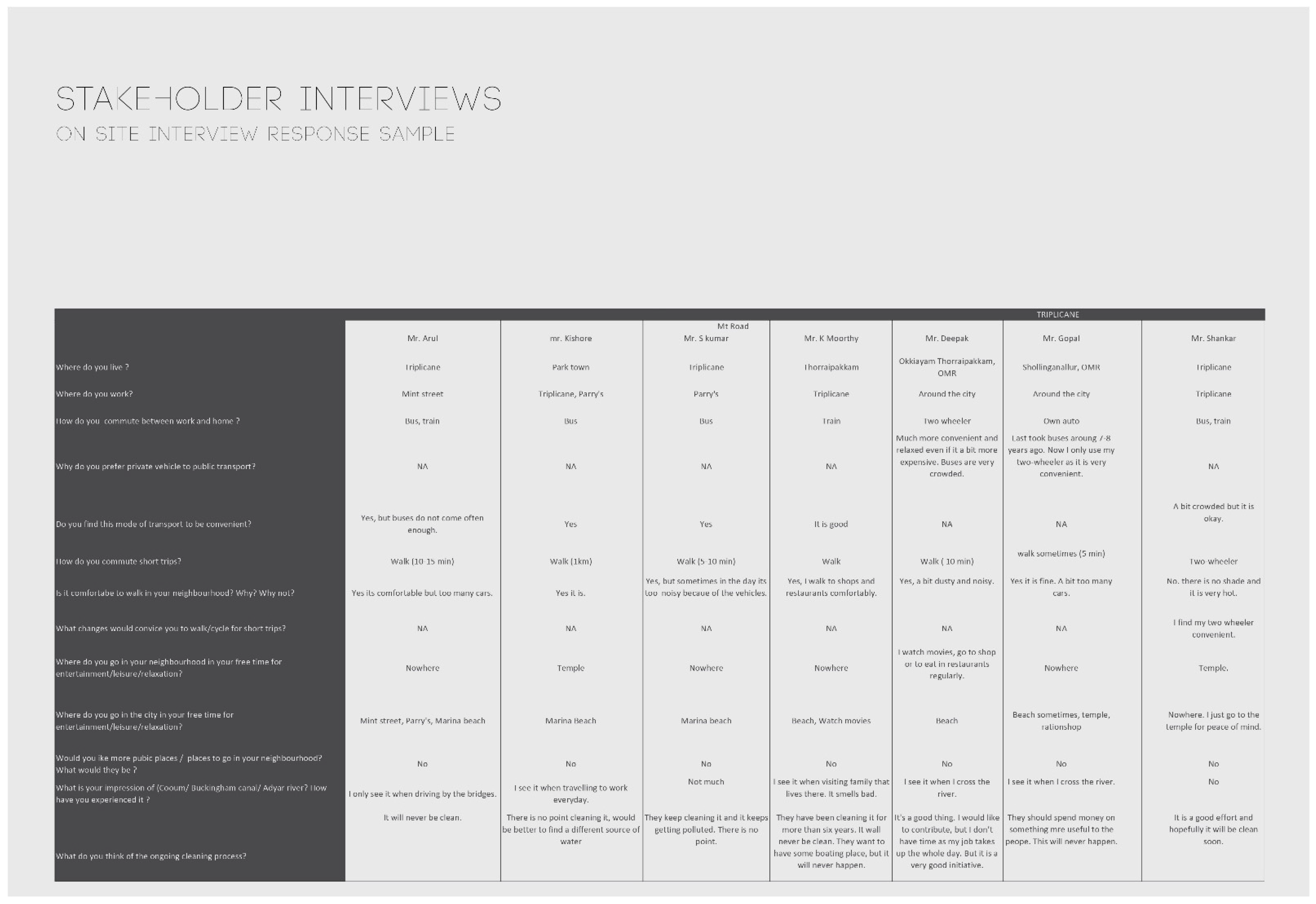
The fieldwork was of utmost importance in contextualizing the meaning of livability to the people of Chennai. This was carried out through local perception studies, on-site interviews with citizens, and semi-structured expert interviews as a means to evaluate the livability indicators that were proposed by the planning agency in India. Local perception studies were conducted by providing a group of diverse and randomly selected inhabitants a standard questionnaire (see
Appendix A) that asked the participants to describe their perception of different aspects of their urban surroundings pertaining to the factors that were considered in the integrated strategy. Further, the participants’ place of work, place of stay, and frequented public spaces were mapped out and considered along with their answers to the perception studies. This overlapped with the morphological analysis of the city, as explained previously. In addition, expert interviews were used to understand the same issues from the perspective of planners. The qualitative analysis of data from interviews was compared with the results of a morphological study and categorization of the city based on network configuration, functions, and density. Together, this provided an understanding of the factors influencing the varying perception of livability across the city. For instance, perceptions regarding travel time, daily movement patterns, and impressions of the ecological systems were verified with a study of the neighborhood and street structure as well as accessibility and visibility of the ecological systems.
Research through design [
22] is a key component of the chosen research strategy, where the design is not just one of the final products of the research but is used as an input into the research process. The broad strategies and systemic relationships that are defined through the preliminary research and analysis were tested, contextualized, and spatialized using the results from design interventions at the test locations in different parts of the city. These locations were selected strategically, based on the output from the analytical methods, ensuring they are present in the different typical categories that were identified. A trans-scalar approach was employed in order to understand and redefine different systemic frameworks at the city scale and their spatial impact at the street scale. The concepts and strategies at the city scale are validated through design interventions at the local scale, lending definition to spatial relationships and evaluating their feasibility. Further, testing through design reveals new possibilities at the metropolitan scale. The metropolitan scale strategies deal with the larger networks and structuring of mobility and ecological systems based on the existing context in the city and the need to equally distribute access to the network of public spaces. As the lens shifts to smaller scales, the contextual input increases and the exact densification process in relation to the green-blue structures and mobility network is defined. The final strategies that are proposed are constantly driven by the larger guiding vision of the metropolitan scale and at the same time, account for local contexts and complexities. This allows for a common goal guiding the city, while the methods of implementation are tailored to local needs and conditions.
3. Analysis
The following sections explain in detail the analysis of the systems that were considered in this research. Specifically, it reflects a contextualized understanding of the theoretical underpinnings that were chosen. Based on this, the synthesis that brings together the integrated planning strategy is detailed.
3.1. Liveability in the Context of Chennai
The need to create more livable cities has been one of the issues that has been identified in Indian cities in recent times [
21]. During the process of economic development, these cities focused on merely providing basic infrastructure, amenities, and employment opportunities, rather than a focus on any form of quality of life. However, as the cities become more globalized and people progress economically, the need for higher living standards has shifted the conversation to the need to think about livability.
Figure 4 shows the spatial indicators of livability that were identified by the Ministry of Urban development in the Government of India in the document “Liveability standards in cities” [
21]. The concept of livability has a spatial, economic, social, and institutional dimension to it. As this article focuses on livability in the public realm, the focus will be on the spatial indicators of livability. The conclusions that were drawn from the fieldwork helped to contribute to a localized understanding of livability.
3.1.1. Inequitable Distribution of City-Scale Public Spaces
From the local surveys and spatial analyses that were conducted, it could be seen that the only city-scale public spaces in the city were the beaches. Other commonly visited destinations were not completely public in nature, such as temples and shopping malls. Owing to the radial corridors of growth in the city, only the city core has access to these beaches as a destination on a daily basis. This was also reflected in the lifestyles of those living in the city core as opposed to in the peripheries, with frequent visits to a city-scale public destination much more likely in the former. Therefore, this shows an inequitable distribution of city-scale public spaces with a significant lack of the same found in newer developments.
3.1.2. Patterns of Use of Local-Scale Public Spaces
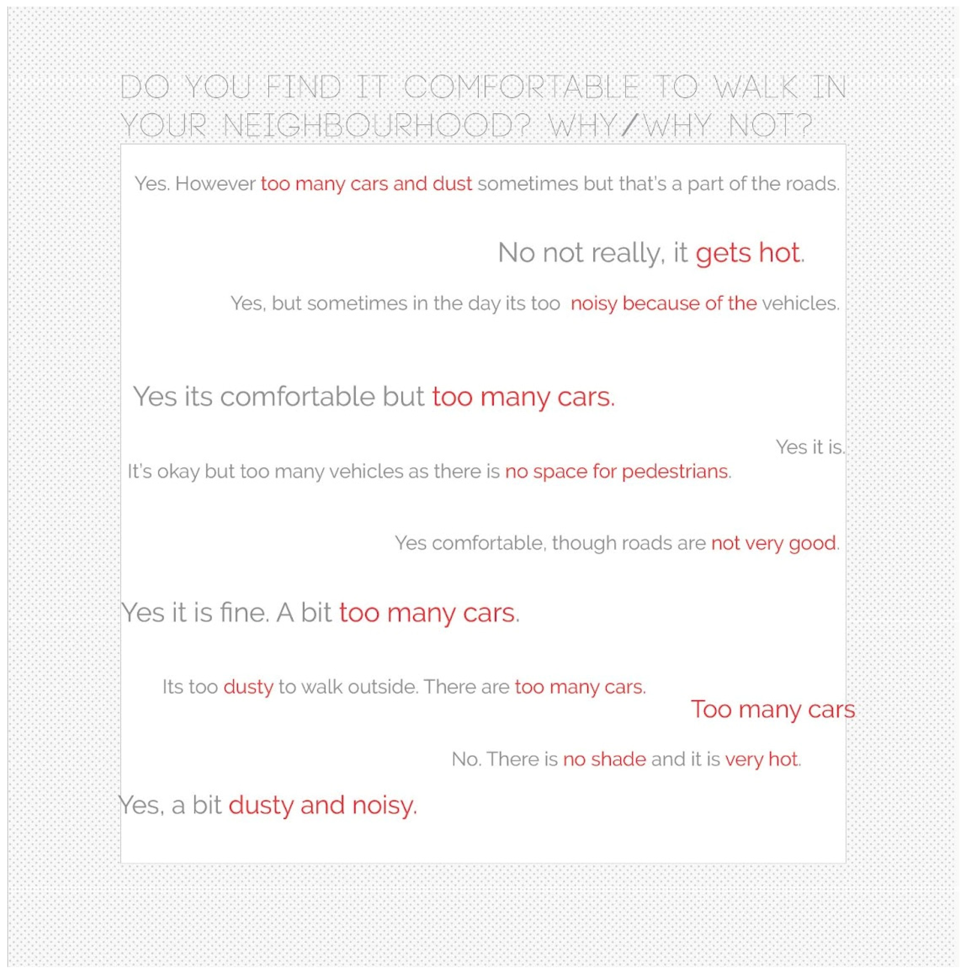
A major finding from on-site interviews and perception studies was people’s attitude towards public spaces (
Figure 5). While Chennai is lacking in everyday public spaces, most people felt that they did not require any more public space in the city. A common reason that was provided for this was that they did not have time for this in their day, most of which was spent working and travelling. The reason for this disconnect between the city and its people could also be traced to the perception studies, where people were at best apathetic towards the ecological open spaces in the city, being physically and visually completely disengaged from it. Further, there was a deep mistrust in the government’s ability to implement any public project successfully. These issues led to daily life patterns that, for many years now, have not included the idea of public space. Instead, public space was seen as a luxury for those who could afford to spend their time on it, rather than a necessity to create a healthy city life. However, the studies also showed a high percentage of people that were comfortable with walking an average distance of one kilometer on a daily basis, despite complaints of vehicular pollution and noise.
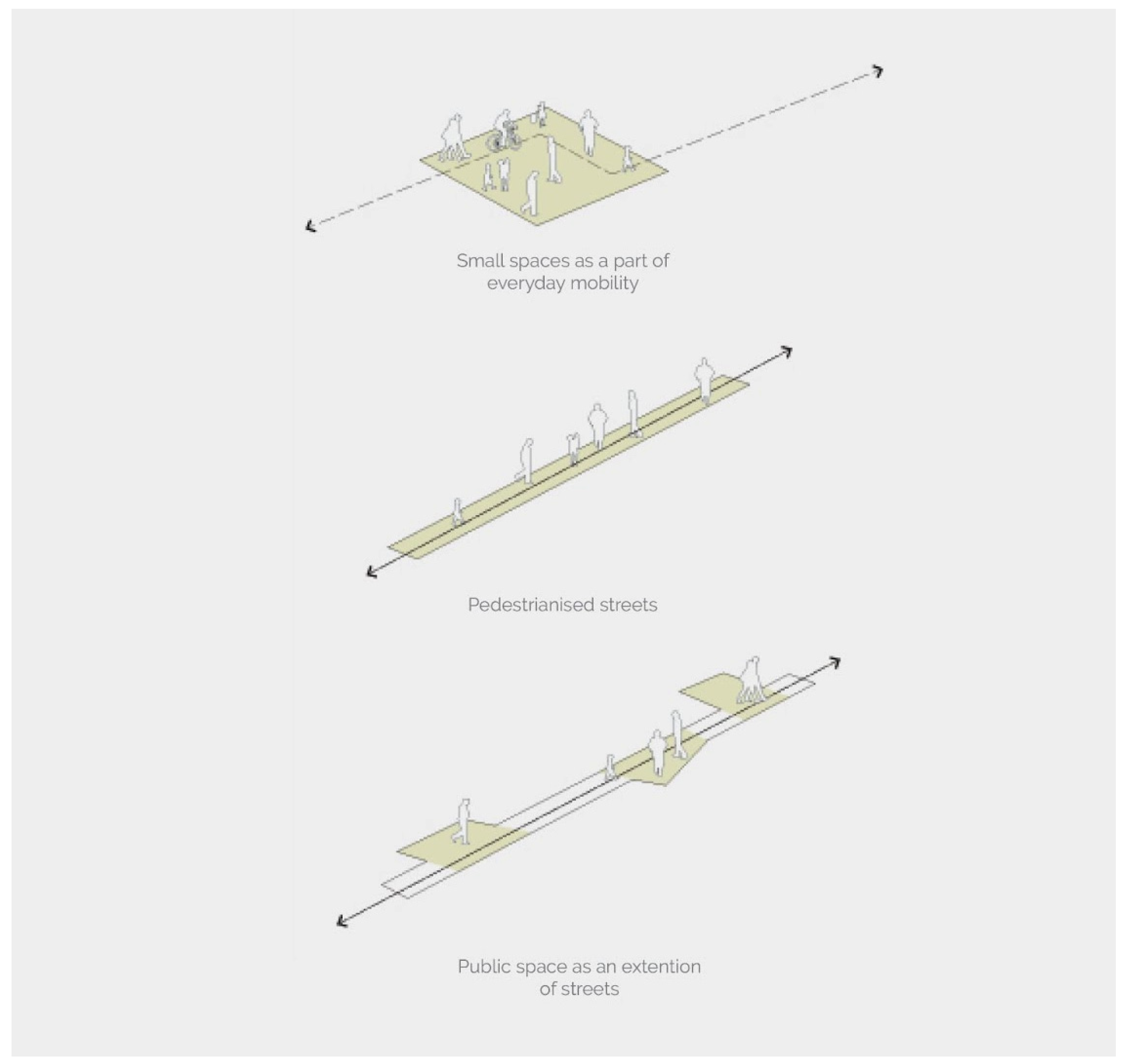
This gave specific input regarding the nature of public space that the city needs. It revealed the short-term potential of implementing smaller-scale public spaces, such as pedestrianized streets and spaces as an extension of these streets (
Figure 6). This would boost the trust in the government’s ability to implement projects for the people, introducing public spaces that were not purely recreational destinations but those that were a part of daily life patterns, such as walking to work or stops on the way. This could, over time, build up into a larger network of public spaces.
It is also important to note that physical distance is not the only factor of consideration when discussing accessibility. Time plays an important factor as well. This can be seen in the peripheries of the city where the IT corridor is located. Most people who worked there found themselves travelling a lot, owing to the sprawling nature of the arterial roads and time spent waiting in traffic. As a result, they did not have too much time in the day for anything else.
Moreover, it is important to have an equitable distribution of public spaces, both large green spaces that bring people into nature as well as local and pedestrian-oriented spaces. The current situation displays an uneven distribution, where some communities have access to spaces such as the beach while others have none in reasonable distance. This need for equitable distribution informs the larger city-scale strategy of green-blue and mobility networks. The local studies that were conducted allowed for a modification to the indicators that were provided by the Ministry of Urban Development, through a contextual understanding of livability.
3.2. Ecological Systems
Historically, Chennai possessed a community-driven water management system that created an intimate relationship between society and ecology. This way of thinking towards the common goods (lakes, rivers, forests, and marshlands) was gradually eroded as the society shifted towards the ideas of public and private space that were introduced in the colonial period [
23]. The rampant urbanization that followed, along with the disconnect between man and nature resulted in the encroachment and depletion of these natural systems. The executive report regarding the eco-restoration of the Cooum River by the Chennai River Restoration Trust (CRRT) shows that the current efforts of restoration focus on providing the ecosystem services that are required, while neglecting the social services that are essential to sustain the process [
24]. Therefore, it becomes increasingly important to adopt a socio-ecological approach to the restoration process. Further, the inability of the government agencies to restore the rivers in the city for a prolonged period of time has resulted in a sense of distrust in the process, as was seen in the local on-site interviews that were conducted. Most people that were interviewed did not expect the restoration to successfully happen. Further, a perception study shows that the water systems in the city are no longer perceived as spaces but as services that are currently failing. This is further exacerbated by the lack of physical and visual accessibility to the water bodies as seen in a morphological mapping of the same (
Figure 7). Therefore, when asked about people’s hopes regarding the restoration (
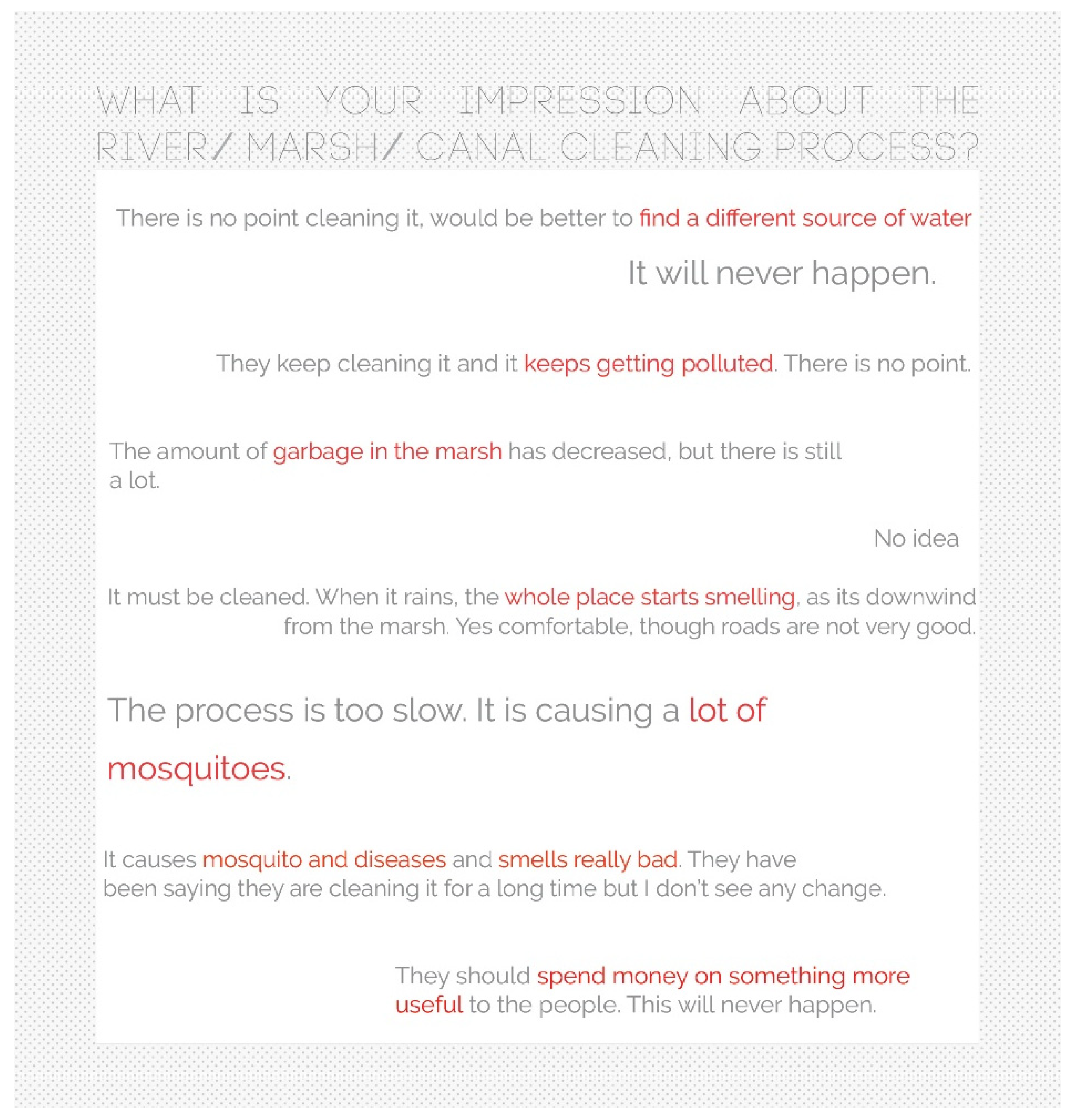
Figure 8), the answers were more centered on issues such as provision of water, mosquito infestations, and foul odors, rather than any aspirations about spatial quality and public functions.
The current efforts to rejuvenate these systems in order to prevent the frequent floods and droughts in the city must take into account the importance of its relationship with the people of the city. These ecological systems, when integrated with the urban fabric, have an immense value in enriching everyday life. Conversely, a positive spatial relationship with these systems also nurtures a sense of responsibility to protect these systems. This mutually beneficial outcome can be achieved through the process of socio-ecological integration. These socio-ecological strategies must specifically focus on improving accessibility to the water edge, activating these zones with appropriate activities and functions, and understanding the spatial implications of the ecological restoration strategies in synergy with the social needs.
3.3. Mobility Networks
Based on national urban development policy, Indian cities, including Chennai, are aiming to shift towards transit-oriented development [
25]. Chennai has an extensive combination of suburban and MRTS lines as well as the metro train lines, which are currently in the process of being built (
Figure 9) However, access to rail transit is not the only factor that facilitates a shift away from private vehicle use. Other aspects such as on- and off-street parking, housing type and tenure, density, and bus services also play a key role [
26]. Specifically, inadequate densities, improper mix of functions, poor accessibility and walkability, and a lack of multi modal integration are some of the larger issues that pose a challenge to the implementation of TOD in Indian cities [
6]. Therefore, at a larger scale, multi-modal connectivity, network configurations and accessibility to jobs, city destinations, and recreation are essential for the public mobility network to be successful, while at the local scale, density and function mix, adequate parking, and spatial conditions that improve walkability are some of the important factors.
The morphological analysis and policy study showed that the challenges in successfully implementing TOD were different in the various parts of the city. The city core was defined by a dense, tightly packed, and fine-grained urban structure, with transit nodes coinciding with important city destinations. However, the challenges arose with last-mile connectivity to other public transport modes and walkability. This was largely due to inadequate pedestrian infrastructure and the location of most train stops along the arterial roads that locally acted as barriers to free-flowing pedestrian movement. The peripheries of the city are largely characterized by arterial corridors along which the major urbanization happens in the form of large blocks and parcels, with the internal areas lacking coherent neighborhood structures and mixed-use functions. The new transit lines being proposed here therefore suffer from insufficient density and mixed-use functions around nodes, as well as poor multi-modal connectivity and accessibility.
Therefore, while the city core requires a transit strategy that intervenes at specific points of the urban fabric to create pedestrian and open spaces and to redefine people and vehicular flows within the existing street network, the peripheries require a strong definition of a neighborhood framework and hierarchy, along which densification can happen, beyond the arterial corridors.
3.4. Densification Guided by the Two Networks
An important aspect of the strategy that is put forward in this article is the definition of a goal for densification. While densification currently is undertaken to deal with the increasing population, this study views densification as a process that can redefine patterns of urbanization in the city. This redefinition primarily places importance on the mobility and ecology networks in the city, where densification is used as a tool, for instance, to make space to revive ecological structures or to activate a mobility node.
The results from the morphological analysis and policy study provide important insights to achieve this goal. Firstly, current regulations define density purely in terms of the gross built area and the plot coverage, leading to the recent regulation change being disproportionately favorable to construction developers and owners of large parcels of land, with no value added to the people and their daily patterns of use of the city. This also limits the definition of density as an architectural attribute, without a direct urban implication. Therefore, density is defined not only by the FSI and GSI at a parcel level, but also considers the distribution of functions and their intensity, both at a larger block scale as well as vertically, across the floors of the building. This allows density to be thought of as a process of defining the way people live and move in the city. Further, different means of achieving a change in density, such as rebuilding, relocation, functional transformation, and infill building are also considered.
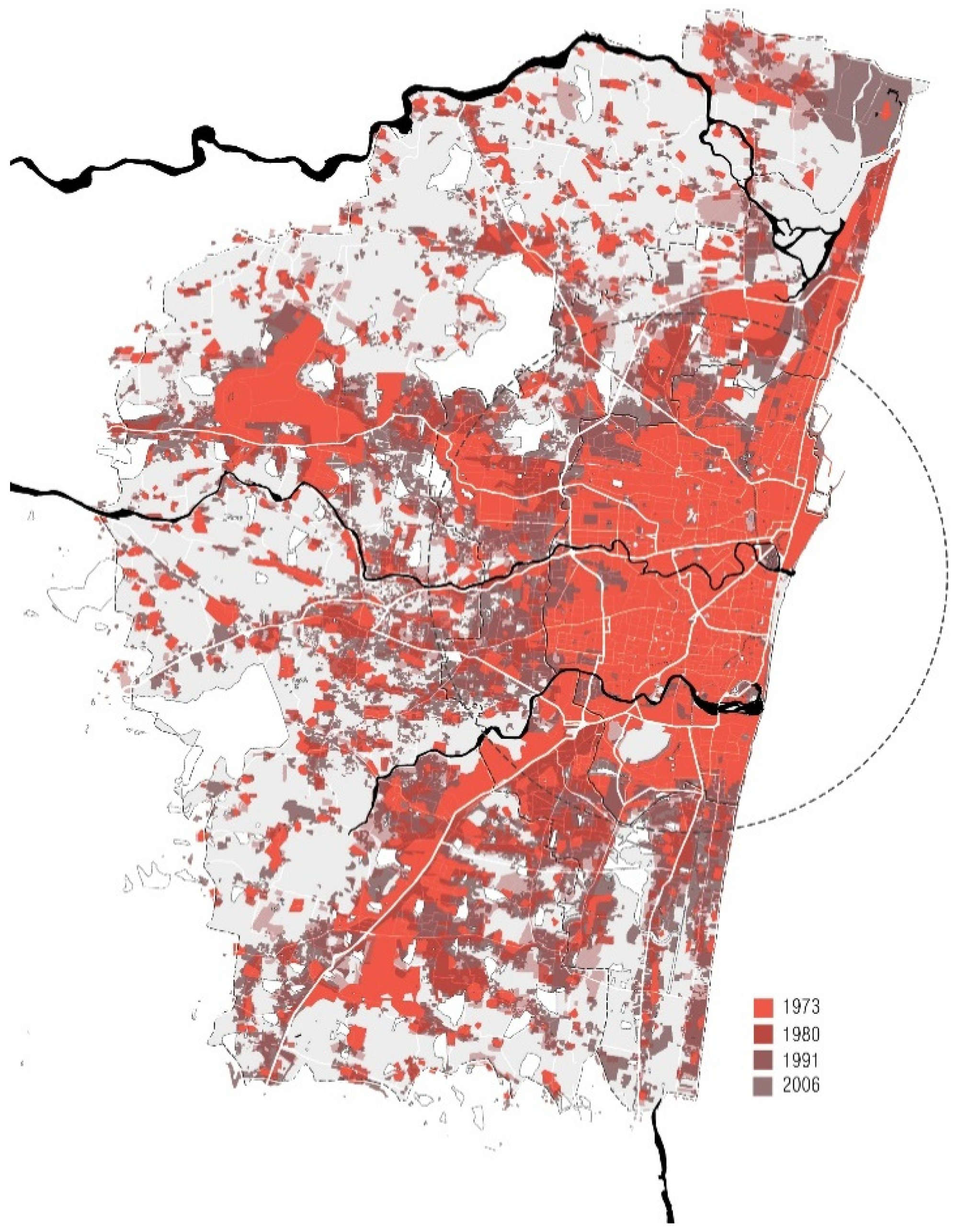
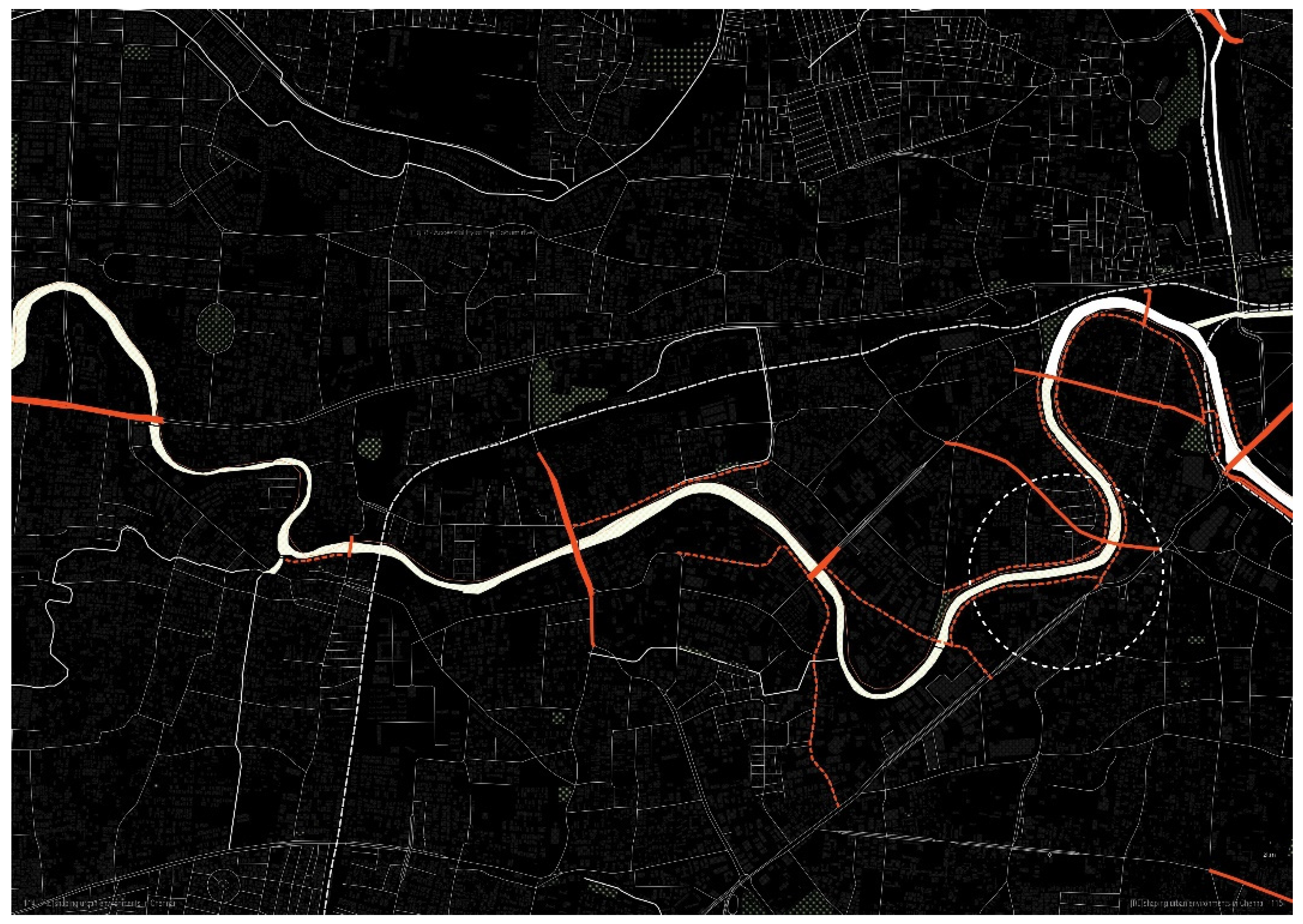
Secondly, the morphological analysis further indicated that the core of the city is almost completely urbanized, with a strong gridded street network while the peripheries have a concentration of densification along the radial corridors (
Figure 10). Therefore, in the proposed strategies, towards the city core, the strategic interventions focus on specific points of transformation where a redistribution of density can be used to activate spaces to improve livability, access the water edge or making metro stops more diverse and active. In the peripheries, the strategies aim to create a strong network in place of the existing development corridor, which requires a larger scale of densification through the area, guided by a newly defined mobility network.
Finally, densification is used to shape more livable public spaces in the city. Therefore, a lot of importance was placed on the potential to create positive experiential qualities for people. In order to achieve this, the concepts of livability, public space, and daily patterns of movement were understood in the local context, as explained previously.
All in all, densification is used as a tool to reshape the city, guided by functions and qualities that are ascribed to the two networks. Different spatial relationships between the mobility network and ecological network afford diverse social spaces that allow for contrasts and transitions in the social realm. This is a much-needed quality in Chennai, which lacks spaces in the city that can complement the fast-paced, vehicle dominated streets of the city [
27].
3.5. Integrated Approach
Synthesizing the goals for the independent systems that are described above, an integrated strategy evolves (
Figure 11). The integrated framework is a city-scale strategy that enables a large reconfiguration of the existing networks in the city. It allows for the ecological systems in the city, currently deteriorating and inaccessible, to become a part of the public space network. This not only enhances the social realm by providing access to larger open and green spaces, but also helps to maintain the ecological conditions within the city by allowing people to engage with and take responsibility for these systems. The mobility network restructures movement patterns by upscaling the vehicular network, leading to its reduced use while strengthening pedestrian connections by aligning them with the green networks, public transit, and important functions.
This approach has the potential to transform the spatial conditions in the city through different means. The primary aim of the transformation is the creation of more accessible green spaces, public places, and livable environments in the city. It promotes a shift from private motorized vehicles to public transport, allowing the decrease in congestion of roads in the city, leading to a better environmental quality and well-being. The inclusion of the ecological systems as part of the accessible urban fabric and a part of daily life patterns adds to the quality of open spaces in the city. Conversely, it also helps to better manage the fragile ecological systems in the city.
As the strategy describes relational qualities and not absolute quantities, it allows for flexibility in the actual implementation in terms of urban form, spatial definitions, and functions. The strategy is a tool that establishes a network thinking in the city that guides the movement of people through it, identifying potentials based on location, scale, and interrelations amongst the networks. The integrated strategy can be utilized as a trans-scalar design and planning tool. At the city scale, it can facilitate a common spatial framework for the different projects that the city is undertaking, in terms of mobility networks, ecological restoration and densification, to find synergies that enable livable environments. At local scales, it can indicate the spatial strategies that are required to ensure that the networks function as intended. This process puts the long-term well-being of the people of the city at the forefront of the design and planning process, by facilitating a more livable city that is walkable, accessible, and fostering a positive relationship with the ecological systems that are present.
While the blue-green grid acts as a structuring element for the urbanization process, it also allows equitable access to different types of open public spaces in the city, through a “slow lane”. Similarly, the transit network upgrades the vehicular grid, to create a strong pedestrian local network in the city. When seen from the perspective of a pedestrian, it becomes a hierarchy of public spaces, the smallest network being local and defined as pedestrian streets while the largest are large natural spaces in the city. Therefore, when considered together, it takes the form of a hierarchical grid where local neighborhoods are structured around the local pedestrian green corridors, while the larger green corridor structure and enable connections amongst many neighborhoods. As described in, “Intensive urbanization: Levels, networks and central places” [
28], it takes the form of a super-grid.
4. Discussion
4.1. City Planning and the Role of Research
This article highlights the role that research can play in the process of city planning and the caution that is required when adopting theories and planning models that are proposed in Western European and North American contexts. Currently, infrastructure growth and the free market largely drive the growth of the city, with no clear spatial strategy or planning framework visible. The masterplan visions for the city are largely expressed as land use maps and building codes, without an explanation of the research that goes into framing such a vision. Furthermore, the proposed land-use pattern is completely independent of tools of development control, such as FSI (Floor space Index), public mobility networks, or ecological systems. While the city does engage with certain planning notions, such as “smart cities” and TOD, this study shows the lacking socio-spatial conditions that are required to successfully implement those aspects. Therefore, there is a clear need for research in relevant theoretical planning models and their careful adaptation into the local context, while framing the city masterplan. Local characteristics such as the urban morphology, culture, and existing planning frameworks all determine the way in which established planning models can be adapted to a different context. This article frames an alternative urbanization strategy for the city of Chennai, taking into account these characteristics. Moreover, the strategy is framed towards the specific goal of livability in the public realm, allowing the needs and aspirations of people to be integrated into the formal planning framework.
Concerning adaptation, the understanding of planning models from the perspective of the local context becomes extremely important. Considering the two-network strategy, the concept focuses on mobility and ecology networks functioning as carrying structures of activities in synergy. As described in the theoretical framework section, this approach would greatly benefit the city of Chennai as a means to rejuvenate its water systems, socially and ecologically, while introducing “slow” activities to life in the city. However, implementing this model in the context of Chennai brings about specific challenges. The densely built fabric and high population density that is found in the city requires the notion of density to be a part of the equation to facilitate the two networks. With the center of the city being almost completely urbanized, the transformation of the city requires an understanding of built density as well as population density to successfully make room for the ecological system and implement a public mobility system. Therefore, the theory of the two-network strategy was adapted to work in parallel with transit-oriented development and socio-ecological integration, bringing in the layers of density and people.
4.2. Match between Local Social Structures and Planning Processes
As elaborated in the theoretical underpinning section, the quality of livability is defined as the people’s perception towards certain spatial qualities that allow them to view their environment positively. The qualitative nature of livability requires it to be understood from the perspective of the local people in the city. This process of contextualization was carried out through local perception studies, on-site interviews, and expert interviews.
There were several interesting conclusions that came out from this study, contributing to a localized understanding of livability. A major finding was people’s attitude towards public spaces. While Chennai is lacking in public spaces, most people felt that they did not require more public space in the city. The most common reason for this was that they did not have time for this in their day, most of which was spent working and travelling. The reason for this disconnect between the city and its people could also be traced to the perception studies where people were at best apathetic towards the ecological open spaces in the city, being physically and visually completely disengaged from it. Further, there was a deep mistrust in the government’s ability to implement any public project successfully. These issues led to daily life patterns that, for many years now, have not included the idea of public space.
Public space was seen as a luxury for those who could afford to spend their time on it, rather than a necessity for a healthy city life. This gave specific input regarding the nature of public space that the city needs. Firstly, it was important to start implementing smaller-scale public spaces, such as pedestrian streets and spaces as an extension of streets. This would boost the trust in the government’s ability to implement projects for the people, introducing public spaces that were not purely destinations of recreational nature, but those that were a part of daily life patterns, such as walking to work or stopping at the tea shop for a snack. This could, over time, build up into a larger network of public spaces. Secondly, it is important to have an equitable distribution of public spaces, both large green spaces that bring people into nature as well as local pedestrian spaces. The current situation displays an uneven distribution, where some communities have access to spaces such as the beach while others have none in reasonable distance. This need for equitable distribution informs the larger city scale strategy of green-blue and mobility networks.
Another result from this research that particularly stood out was the lack of public interest in the improvement of the social spaces in the city. This came down to the daily life patterns and the lack of trust in the authorities. Therefore, initiations of outreach programs, workshops, and awareness campaigns emphasizing future potentials in regenerating the pedestrian realm of the city are important. The view of “public space as a luxury” must shift to “public space as a right”.
From a wider urban planning perspective, the study of local perceptions and aspirations also demonstrated the need for a stronger bottom-up component in the planning process. While the 73rd and 74th amendment to the Indian constitution was predicated on giving back power to the local people and local governments in shaping cities, the planning process is frequently highly complex with multiple agencies involved where questions and problems of accountability can arise [
11]. Local stakeholder views are frequently only incorporated at the end of the planning process rather than at earlier stages (e.g., visioning). Studies of the participatory planning processes in other Indian cities also illustrate the need for input from people with diverse knowledge and expertise, in addition to citizen engagement [
29]. This is reflected in the framing of the planning strategy in this article, where it can be seen that while it is important for the vision to be shaped by input from local citizens, it is also important to consider inputs from different experts in the field in order to appropriately translate qualitative information into a design and planning strategy.
4.3. Limitations and Recommendations for Future Research
The current governance structure in Chennai is weak, with rampant corruption and the lack of a transparent process of research, design, and implementations. Further, too many government agencies and departments work in parallel without a strong process or intent of integration. This has led to illegal developments, improper implementation of city projects, and, more often than not, a lack of proactive action and strategy in the context of city planning. This article proposes several spatial interventions and design strategies that require a high degree of spatial governance and policy implementation, which is currently not the case. This requires an integrated approach from agencies that are responsible for not only the building development rules, public transportation, and river restoration, but also public utilities, traffic, and planning departments. While this is a limitation to the implementation of this framework, it is viewed from the perspective of a design exploration that exhibits possibilities of transforming the city to facilitate a diverse and livable public realm, using the development processes that are already undertaken by the city. Further, this study also intends to showcase the possibilities of creating a positive public environment for the people of the city who currently believe that these kinds of urban transformations are impossible, due to the prolonged lack of effectiveness in spatial governance.
This research deals with ecological systems purely from a socio-spatial perspective. Therefore, the aspect of biodiversity, resilience to climate change, and natural disasters are not within the scope of this project. When considering the concept of socio-ecological integration, the goals for ecological remediation are aligned with those that are proposed by the city already, without further analysis. Rather, the focus is on how these goals can be achieved by also activating the ecological systems as social spaces to engage with the city. Therefore, the socio-ecological integration aspect is approached through the lens of the human dimension, in order to demonstrate the effect of implementing this restoration in synergy with mobility networks and the densification process. The next step to this process would be to start deepening these ecological goals, to consider climate change and its increasing risks, as this isn’t currently planned for by the authorities.
This research deals with the analysis of diverse social groups and morphological typologies leading to different requirements and usage of public space within Chennai. However, the research only captures this diversity to a limited extent, as the city is home to a very large number of different cultures, in terms of religion, socio-economic class, occupation, immigrants from other parts of the country, and so on. Each of these groups have a very distinct culture that affects the way they use space. However, due to the limitation of time, the analysis of the characteristics of space will be taken forward with a broader classification.
One of the important aspects of the project deals with increasing the use of public transport over private vehicles through spatial interventions and design strategies. While Chennai has several modes of public transport such as the Metro system, the suburban and MRTS train system, and the MTC public bus system, this project predominantly focuses on the metro system, as it is one of the most recently implemented public transit systems, with several lines yet to be constructed, allowing for more possibilities with respect to the design proposals. The metro currently has not achieved its intended ridership due to the fact that the entire network is not complete, lacking spatial conditions around the metro stops, and very high-ticket costs. This project specifically focuses on the solutions for other spatial issues that cause this problem, while practically, the issues of reduced ridership and increased travel costs remain unsolved, while the ticket cost is an important issue to be resolved as well.
The city currently lacks comprehensive and up-to-date data on building footprints, building heights, densities, and household quantities. This complicates the process of defining precise densification regulations. Undertaking this mapping process and making it available for research purposes in the public domain will greatly improve the results of the planning and design interventions in the city.
5. Conclusions
This article has analyzed the existing urban conditions and planning framework of Chennai through the lenses of urban morphology, livability, ecological conditions, and mobility patterns. It has set out an alternative approach to strategic design and planning in the city that brings together the layers of ecology, mobility, and density towards the goal of creating a more livable public realm. The proposed integrated framework is a city-scale strategy that enables a large reconfiguration of the existing networks in the city. It allows for the ecological systems in the city that are currently deteriorating and inaccessible to become a part of the public space network. This not only enhances the social realm by providing access to larger open and green spaces but also helps maintain the ecological conditions within the city by allowing people to engage with and take responsibility for these systems. The mobility network restructures movement patterns by upscaling the vehicular network, leading to its reduced use, while strengthening pedestrian connections by aligning them with the green networks, public transit, and important functions. The process of densification is utilized as the predominant means of transforming the city to accommodate for the super-grids.
Many other Indian cities have problems of unchecked urbanization, similar to Chennai, where urban planning takes insufficient account of the ecological and mobility systems. It is likely that similar sets of methods, integrated frameworks, and strategies can be applied to a range of other Indian cities. At the local scale, the design strategies may of course need to be adapted, and context-specific interventions, specifically those pertaining to the climatic conditions and the current ecological condition, will need to be redefined. As the case of Chennai illustrates, concepts such as livability in public spaces are deeply rooted in specific contexts and need to be considered carefully in the planning process. A similar process of trans-scalar context analysis and perception studies through fieldwork could be used to determine a contextualized understanding of livability in other similar cities.


