Article

Analysis of the Relationship between Beijing Rail Transit and Urban Planning Based on Space Syntax

Department of Architecture and Building Science, Graduate School of Engineering, Tohoku University, Sendai 980-8579, Japan
*
Author to whom correspondence should be addressed.
Sustainability 2022, 14(14), 8744; https://doi.org/10.3390/su14148744
Submission received: 12 May 2022 / Revised: 7 July 2022 / Accepted: 14 July 2022 / Published: 18 July 2022

Abstract

:
Transportation infrastructure planning is one of the essential ways to achieve a carbon-neutral society in China’s future. With regards to sustainable urban development, the Green Low-Carbon policy for Transportation is set out in the 14th Five-Year Plan Outline 2021–2025. However, there are only a limited number of previous studies that systematically combined land-use planning and urban transportation evolution to clarify the structural issues in urban transportation optimization. In this study, we use traditional analysis and space syntax analysis to examine the relationship between the urban development of Beijing and the evolution of its rail transit transportation. After analyzing Beijing’s multi-center and multi-circle rail transit structure, it was concluded that the current division of labor in Beijing’s rail transit is unclear. Analysis using space syntax shows that connecting suburban centers using suburban railways improves accessibility better than subways. However, after analyzing the synergy between these factors, it is found that the application of space syntax needs to be analyzed in combination with the actual situation.

1. Introduction

China has pledged to ensure that CO2 emissions peak before 2030 and to achieve carbon neutrality before 2060 [1]. For sustainable urban development, the 14th Five-Year Plan Outline (2021–2025) lays out the Green Low-Carbon policy for Transportation [2]. China’s transition to a carbon-neutral society would rely heavily on transportation infrastructure planning. To solve the problem of metropolitan polarization, a multi-center and multi-circle urban spatial structure is proposed. From the development of satellite cities to the current multi-center urban structure, the formation of urban spatial structures is inextricably linked to urban transportation systems. The research on the relationship between urban spatial structures and traffic-supporting facilities focuses on the interaction between urban traffic and urban spatial structure, the optimization of the rail transit system, and the methodology of the traffic structure research, among other factors. The research on the relationship between urban transportation and urban spatial structures mostly discusses the coordinated development of the rail transit systems and the multi-center metropolis. Li, C. proposed that the urban multicenter pattern should be based on the multi railway station [3]. Zhou, H. studied the interplay between urban form transformation and the development of traffic modes and divided it into different evolving phases [4]. These studies point out that a complementary relationship should be established between the urban morphology and the urban transportation mode. In terms of optimizing a rail transit system, the construction of suburban railways and the necessity of multi-rail transit integration are elucidated. Based on the development status and development trend of Beijing’s urban rail transit, Zheng, M. put forward the concept and the goals of “multi-network integration” for Beijing’s rail transit [5]. Wu, J. studied the profitability of the suburban railway in Tokyo and noted its inspiration for the development of China’s own suburban railway [6]. Qin, Y. called for the planning and construction of suburban railways and intercity railways to take place as early as possible, along with the construction of subways [7]. Based on the Tokyo metropolitan area rail transit system, Rong, C. provided a reference to build the urban rail transit system in the metropolitan area with the integration of various rail transit systems [8]. These studies suggest that attention should be paid to the construction of suburban railways, and a variety of rail transit network structures should be formed. The feasibility of space syntax and its topological relationship are utilized in the quantitative analysis method of traffic structure research. Song, X. provided a systematic and multi-dimensional comparison of space syntax analysis methods [9]. Li, J. used the integration value of space syntax to analyze the effect of the inter-city railway on the urban agglomeration development of the Beijing-Hebei-Tianjin area [10]. Based on seven selected subway lines in Tokyo, Zhu, W. J. believed that the space syntax method was suitable and feasible for the calculation of the quantitative accessibility index of subway lines [11]. Based on the space syntax theory, Ye, M. A. analyzed the topology structure of Beijing and Shanghai’s mass transit networks, respectively [12]. This study argued that the integration value of space syntax can be used to describe the strength of transportation accessibility. There is much research on the relationship between urban space and rail transit, but there are relatively few studies on the evolution of urban space and rail transit in Beijing. Only Wang, Y. [13] and Wang, S. [14] have studied the evolution of urban space before and after 1949 in Beijing, during distinct historical periods. These two studies mainly elucidate urban planning and urban construction, and the research on the relationship between rail transit and urban development is not the focus. Research on the relationship between rail transit and urban planning throughout the entire historical period is relatively blank. In recent years, the research on the relationship between urban space and rail transit has centered on the economic benefits brought by rail transit for urban spaces and how this impact affects the urban layout. For example, Zhang, C. believes that stations with higher rail transit accessibility will generate an agglomeration effect and attract more employment, which will lead to a shift in land use surrounding the station [15]. Liu C. proposes differentiating Beijing’s rail transit price based on its space cost allocation [16]. At present, few studies are focusing on the optimization of the rail transit network structures to adjust the urban spatial structure. The vast majority of research into the application of space syntax to examine the rail transit structure focuses solely on the subway system or the railway system. Chen, X. used space syntax to evaluate the performance of metro-led urban underground public spaces in Shanghai [17]. Pang, L. analyzed the accessibility of the current situation and planning of the Sichuan railway network based on space syntax [18]. Only Chen, P. N. used space syntax to analyze London’s multilevel transportation network, but they did not point out the possible limitations of the space syntax analysis of multilevel transportation networks [19]. There is relatively scarce literature on the rail transit network of the national railway, subway, and suburban railway using space syntax. This study, therefore, elucidates the relationship between Beijing’s urban planning and its rail transit in different historical periods, and explores space syntax application in various rail transit structures. This study fills the gap in the research on the relationship between Beijing’s rail transit and its urban planning in all historical periods, and it finds inconsistencies between the graphics and texts in the latest version of Beijing’s urban planning. In addition, the limitations of using space syntax to analyze various rail transit network structures are explained, which is helpful to improve the accuracy of the application of space syntax in rail transit structure analysis.
The remaining research content falls into three sections. Section 2 discusses the research framework and the methods used. In Section 3, the obtained research results are presented. Section 4 summarizes the conclusions and provides some suggestions for future research.

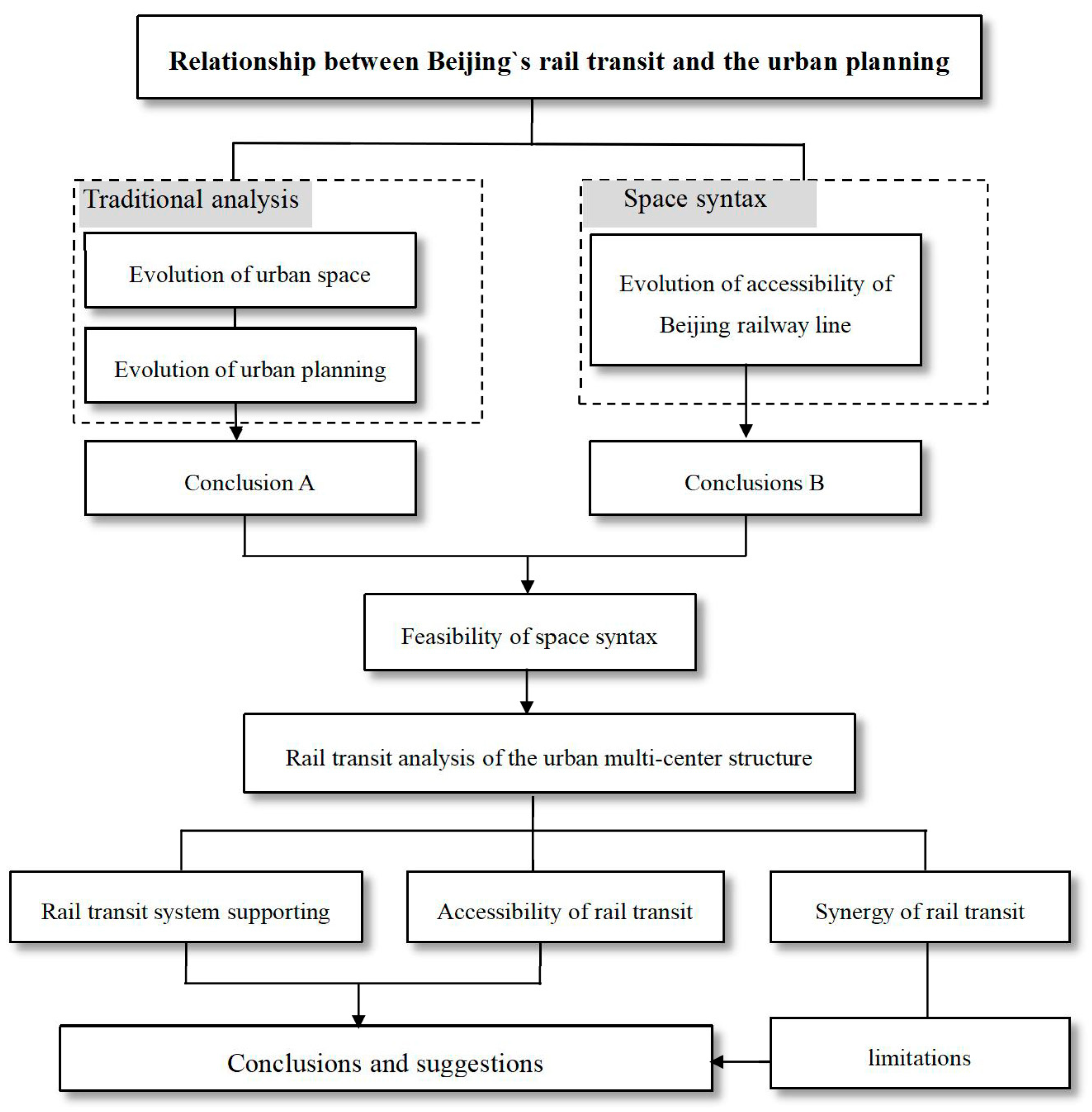
2. Research Framework and Methods

2.1. Research Framework

Beijing’s rail transit has played an essential role in the evolution of Beijing’s urban space. Therefore, the relationship between Beijing’s rail transit structures and its urban planning is considered as the research object. Using traditional analyses and space syntax, the evolution of Beijing’s urban spaces and the multi-center structures related to Beijing’s rail transit structures in urban planning are studied.
Firstly, this study uses traditional analytical methods to analyze the relationship between Beijing’s rail transit and the evolution of its urban planning. Secondly, it uses space syntax to analyze the evolution of Beijing’s rail transit and compares this with the analysis results of the first step to verify the feasibility of space syntax in the analysis of rail transit structures. Finally, it analyzes the rail transit structure planning of Beijing’s multi-center structures using space syntax and draws conclusions from this (Figure 1).

2.2. Methods

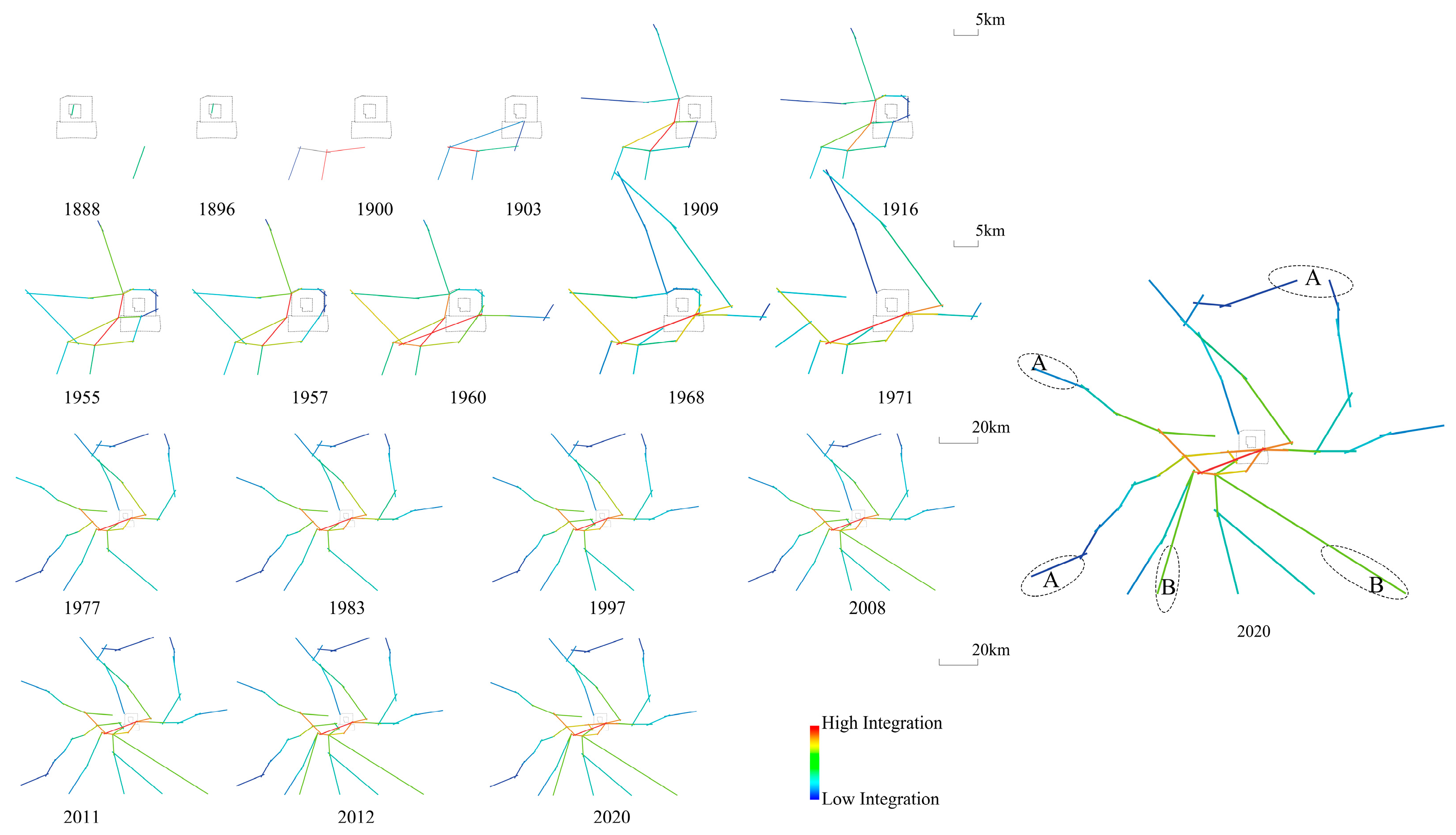
2.2.1. Accessibility Based on Topological Relation

Space syntax was proposed by Bill Hiller and Julienne Hanson in the 1970s [20]. It provides a set of quantitative analysis methods for understanding space configuration and a new perspective for understanding the complicated urban transportation system. In 1959, Hansen Walter G. proposed the concept of accessibility, which was used to express the degree of convenience from a certain location to a different location in a given transportation system [21]. Space syntax is the use of topological methods to perform quantitative calculations of spatial relationships. The higher the spatial depth value, the smaller the integration value, which means that the accessibility is worse (Equation (1)).
I i = 1 R R A i = n [ log 2 ( n + 2 3 ) 1 ] + 1 ( n 1 ) ( M D i 1 )
where Ii, integration; RRAi, real relative asymmetry; n, number of nodes; MDi, average depth value.

2.2.2. Application of Space Syntax in the Beijing Rail Transit Line

The application of space syntax in rail transit has been practiced by many scholars. The relationship between rail transit stations conforms to the spatial topological relationship, and the accessibility of these stations is related to the spatial accessibility of the urban area where each station is located. If a train needs to pass through more stations to arrive at its destination, then this indicates that the station’s spatial topology depth is deep, and its accessibility is poor. Accessibility is represented by the integration of the space syntax. Therefore, we divide the rail transit line through the station position and turn it into an axial line. Then, putting the axial line into DepthmapX for topology calculation, it returns an expression map of the integration. In the space syntax, the integration values of rail transit systems are graphically represented as color lines to describe the strength of a rail transit system’s accessibility. The warm-colored lines in the integration expression graph represent high integration, and the lines with the highest integration are shown in red. Correspondingly, the blue line represents poor accessibility.

3. Results

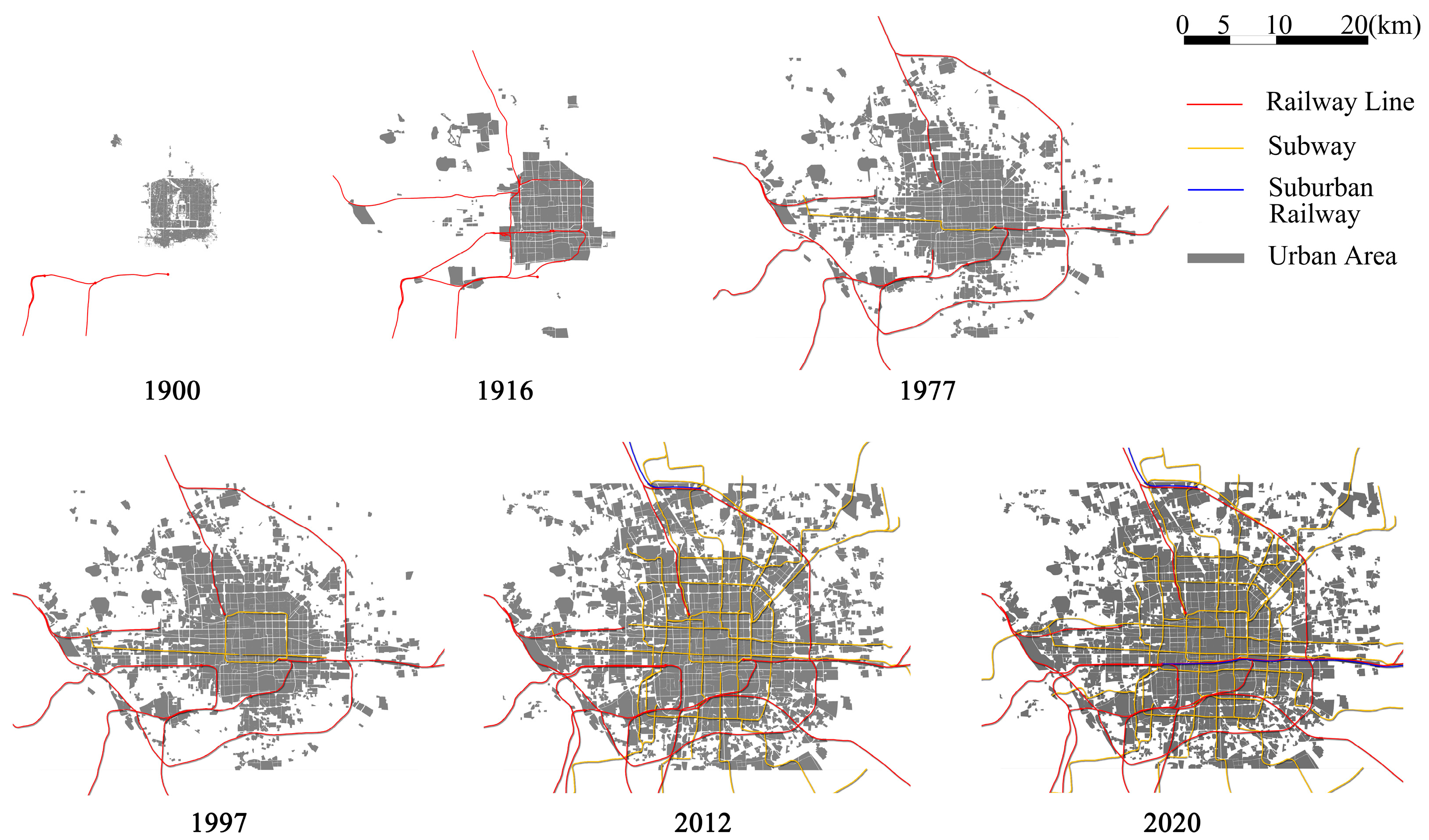
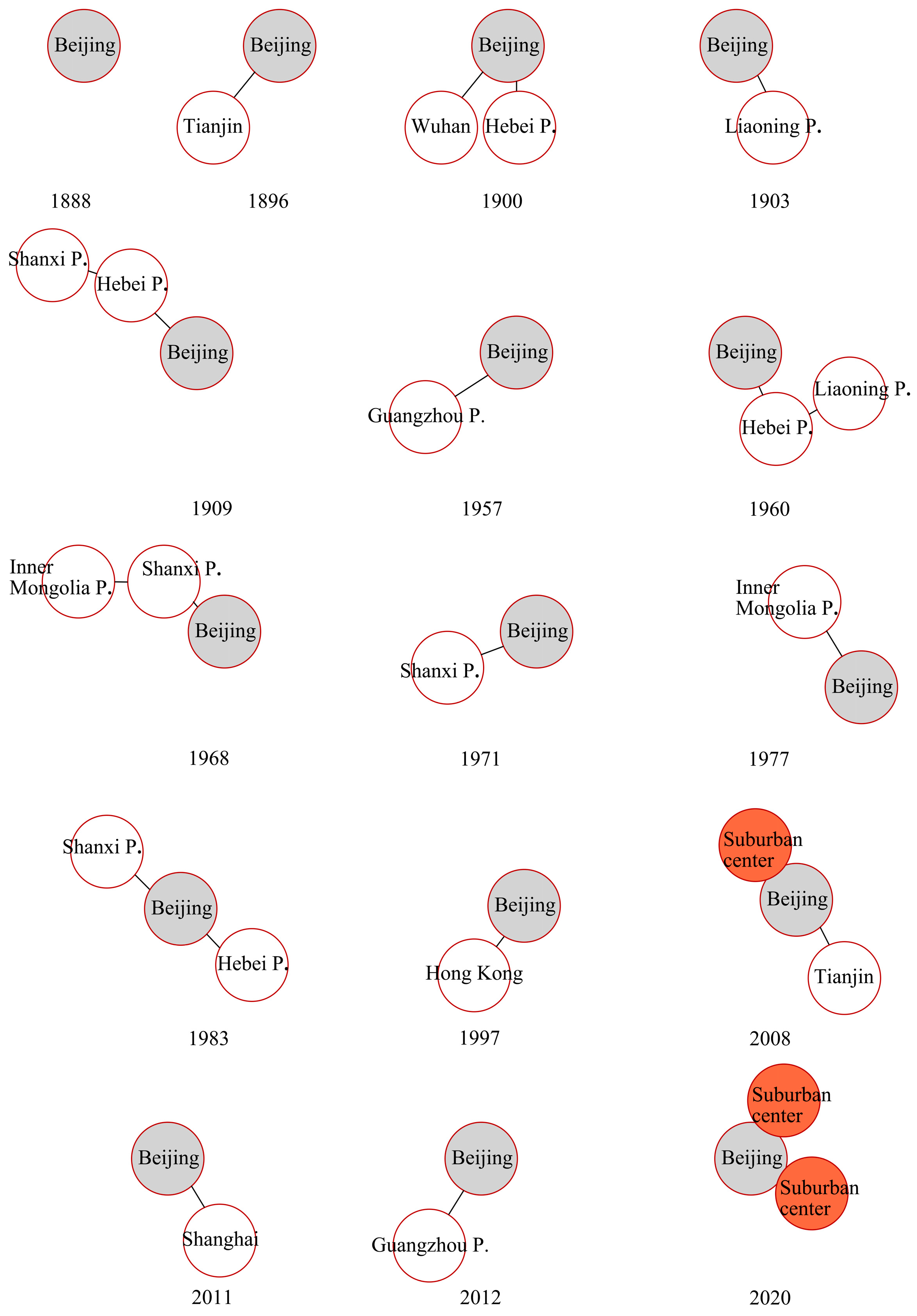
3.1. Evolution of Urban Space and Urban Planning

3.1.1. Evolution of Urban Space

Through the evolution of urban space and rail transit systems in Beijing for more than 100 years, it was found that before 1997, many urban expansion spaces were not connected by railway lines. After 1997, many subway lines were built based on the original urban space (Figure 2). Beijing’s urban space has a low degree of coupling with the railway lines, but it has a substantial degree of coupling with the subway lines.
Beijing’s rail transit includes the railway and subway lines. Beijing’s railway line has evolved in three stages: passive introduction into the city, active construction by the government, and cooperation with the national strategic deployment. In 1888, the Ziguangge Railway was built by the Qing government, and it was the first railway accepted by the government. Since then, railways have been continuously built in Beijing. The analysis of the construction objectives for the development of the railway line shows that the authorities have long paid attention to the trunk link between cities but provided little support for developing suburban Beijing (Table 1 and Figure 3). In addition, the evolution of the railway lines shows that the suburban railway in Beijing appeared rather late when compared to others.
Only one subway line existed in Beijing in 1977, and after 20 years of development, there were only two subway lines. However, after Beijing won the right to host the Olympic Games in 2001, the subway began to develop rapidly. By 2012, the subway pattern had taken shape. The rapid formation of the Beijing subway over this ten-year period has led to the passive coupling between subway lines and urban space, intensifying the phenomenon of single-center agglomeration [24]. Beijing’s subway development, like the suburban railway, lags in comparison to urban space development.
Presently, the Beijing and suburban railways are not effectively interconnected by the subway system, and the various rail transits are separated. The evolution of Beijing’s rail transit reflects the fact that rail transit lags in comparison to urban space progression, and more urban spaces have to rely on urban roads. This leads to low coupling between rail transit and urban space.

3.1.2. Evolution of Urban Planning

Beijing’s urban pattern was not traditionally planned before the founding of the People’s Republic of China; however, planning determining the current urban pattern began after the founding. In 1953, the “decentralized group” layout of Beijing as a large industrial city was formulated, supported by the Soviet Union, which laid out the urban pattern of Beijing [25]. The urban planning in 1982 removed the expression of Beijing as a modern industrial base and redefined the urban nature as a national, political, and cultural center [26]. The 1992 plan proposed the development of high-tech and tertiary industries and adhered to the layout of satellite cities and “decentralized groups” [27]. In 2004, building a spatial, strategic layout of a multi-center metropolis was proposed [28]. Furthermore, in 2017, building a multi-center and multi-circle urban development pattern was suggested [29] (Table 2).
From 1953 to 1992, a “decentralized group style” was formed in the suburbs of Beijing, and a satellite city was built in the outer suburbs, forming a spatial pattern of “child and mother city.” However, the development was slow due to the inconvenient traffic connection between the satellite city and the urban area [30]. From 2004 to 2020, Beijing’s urban planning focused on implementing a public-transport-oriented development strategy to realize the coordinated development of land and transportation and to transform the approach of passively supporting urban construction to guide urban development [31]. Suburban railway lines were also built at this time. However, the slow construction of satellite towns of Beijing across periods was due to the insufficiency of the suburban railway.

3.2. Feasibility of Space Syntax

By analyzing the evolution of Beijing’s railway using space syntax, the changes in urban spatial accessibility can be obtained (Figure 4). From 1888 to 2020, the stations with high accessibility were located near to the central areas of the city, while the line color of the urban outer areas is cool-toned (position A in the Figure 4), indicating that the accessibility of the outer areas of Beijing is poor. High-speed railways built after 2008 are more accessible due to them having fewer stations (position B in the Figure 4). However, this refers to the strong accessibility between cities, not the accessibility of Beijing’s urban space. Beijing has long paid attention to the construction of inter-city railway trunk lines, and the construction of the suburban railway is relatively slow, resulting in insufficient accessibility to the outer areas. This is consistent with the above analysis of the evolution of Beijing’s rail transit systems. Therefore, the feasibility of space syntax in the analysis of rail transit structure has been verified.

3.3. Rail Transit Analysis of the Urban Multi-Center Structure

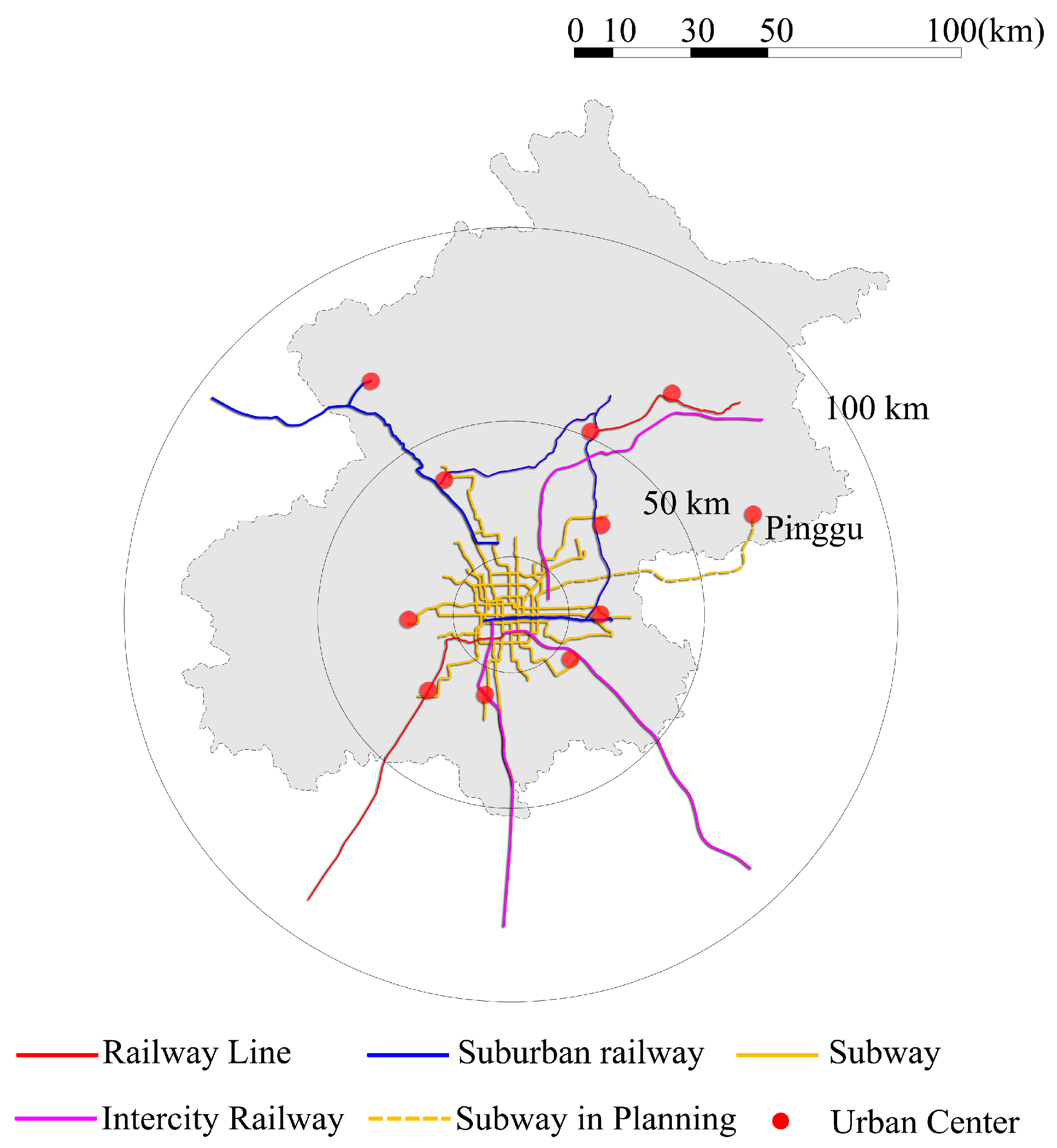
3.3.1. Rail Transit System Supporting

To change the development mode of single-center agglomeration, a multi-center and multi-circle urban development model is proposed. Different rail transit systems support different suitable transportation distances due to their different speeds and traffic volumes. However, an analysis of the present rail transit facilities of Beijing’s urban centers suggests that the connection between Beijing’s central city and its suburban centers has not formed a clear system. Furthermore, the rail transit systems are independent of each other, and the service scope of each transit system is unclear (Figure 5). The latest version of Beijing’s urban planning proposes the development of circle transportation. The first (radius 25–30 km), second (radius 50–70 km), and third (radius 100–300 km) circles are dominated by the subway, suburban railway, and intercity railway, respectively [29]. At present, in addition to the S1 and S2 suburban railway lines, Beijing completed the transformation of the suburban railways of and the Tong-Mi Line and the Huairou-Miyun Line in 2020, speeding up the construction of the suburban railway. However, most suburban centers have not built or planned special suburban railways to connect with the central urban area. Many suburban centers in the second circle rely on the subway in the central urban area. Pinggu, which is close to the third circle, also plans to connect to the central urban area using a subway. This reflects the poor division of labor and the joint problems between suburban railways and subways. Suburban railways appear in the first circle, and subway lines are planned to be built in the second circle. Some scholars have pointed out that if the subway in the central urban area is extended to the surrounding urban centers, then the long-distance extension of the subway will lead to more stations, slow transportation speeds, and a saturated transportation capacity. Thus, it would not be able to meet the one-hour commute demand between the suburban center and central urban area [32]. The slow development of suburban railways and subway lines that act as suburban railways highlights the lack of communication between rail transit departments. Whether various rail transit systems can be integrated to form a systematic structure has become a vital issue, restricting the formation of the spatial structure of Beijing’s multi-center city.

3.3.2. Accessibility of Rail Transit

Each rail transit line is divided by its stations and the space syntax software, DepthmapX, is used to obtain an integration analysis (Figure 6a). The locations at which there is no station at the intersection of the rail transit lines are unlinked (Figure 6b). According to the software algorithm (Equation (1)), the integration represents the level of accessibility, which is related to the node’s depth value. The end of the subway-connecting line in the suburban center of the second circle in Beijing is blue, and the suburban railway-connecting line in the suburban center of the third circle is green. This shows that the accessibility of the second circle of the suburban centers connected by a subway is lower than that of the third circle of suburban centers that are directly connected by a suburban railway. In fact, in terms of station setting, suburban railways have fewer than subway lines do, and their topological depth is lower than that of subway lines. The accessibility of suburban centers through suburban railway links is indeed high. However, the extension of the subway line to the suburban center would reduce its accessibility due to the increase in the number of stations and the increase in the depth of the topology. The topological logic analysis of space syntax further reflects that the accessibility of connecting the suburban center directly through the suburban railway is better than doing so through the subway. Since the spatial topological relationship does not involve speed, the speed of different rail transit systems is ignored. In addition, the maximum speed of the Beijing subway is 80 km/h, and the design speed of the suburban railway is 100~160 km/h. Considering the speed, the suburban railway in the city center is obviously more accessible. Therefore, to enhance the accessibility of each urban center, it is particularly important to clarify the service scope of each rail transit type.

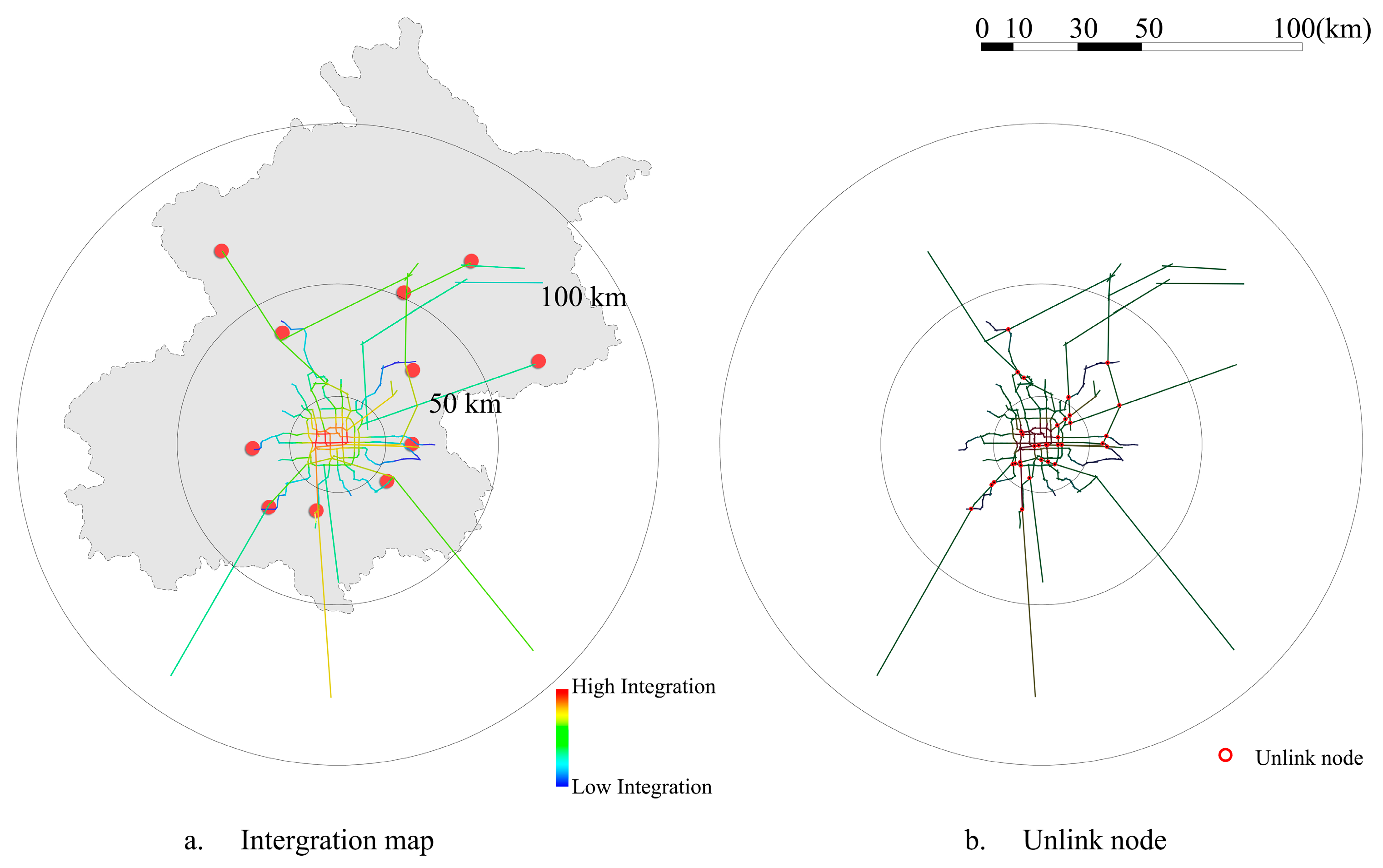
3.3.3. Synergy of Rail Transit

Axial synergy is defined as the correlation between radius-3 and radius-n integration. It measures the degree to which the internal structure of an area relates to the larger-scale system in which it is embedded [33]. The synergy describes the similarities between the part and the whole. Its value exceeds 0.5, indicating a strong correlation (Equation (2)).
R 2 = [ ( I n t r I n t r ¯ ) ( I n t n I n t n ¯ ) ] 2 ( I n t r I n t r ¯ ) 2 ( I n t n I n t n ¯ ) 2
where Intr: local integration when the step number is r, and Intn for whole integration.
The synergy value R2 of Beijing’s rail transit is 0.649062, which is greater than 0.5. This shows that there is a strong similarity between the part and the whole of Beijing’s rail transit structure (Figure 7). However, Beijing’s urban rail transit systems are currently dominated by subways and there are only four suburban railways. Currently, Beijing’s suburban railways are not sufficient, and the high value of synergy does not mean that Beijing’s rail transit structure is perfect. Therefore, the merits of the rail transit structure cannot be judged by numerical values alone. It is also necessary to make a comprehensive judgment based on the actual situation.

4. Discussion

The analysis of the evolution of urban space and urban planning suggests that Beijing’s urban space and rail transit evolution is in a state of low coupling.
The conclusions of this paper are as follows:
(1)
After analyzing Beijing’s multi-center and multi-circle rail transit structure, it is concluded that the current division of labor in rail transit in the latest version of Beijing urban planning is unclear. There are inconsistencies between the graphics and texts of Beijing’s urban planning that need to be corrected.
(2)
Analysis using space syntax shows that connecting suburban centers using suburban railways improves accessibility better than subways can. Extending subway lines to outer suburbs is not suitable.
(3)
The application of space syntax in rail transit structures has been verified. However, the analysis result of the space syntax needs to be examined in combination with the situation on the ground. There may be limitations to the analysis of various rail transit network structures using space syntax. When the rail transit network is dominated by one type of rail transit, the synergy index may not reflect the pros and cons of the actual rail transit structure.
Since the space syntax is calculated based on the topological depth, the rail transit operation mode of over-stopping will reduce the topological depth value of the station, which is not covered in this study. In future research, the rail operation mode can be incorporated into the calculation to optimize the structure of rail transit.
Beijing’s urban space and rail transit development influence and promote each other. The result of urban spatial evolution in Beijing reflects the importance and timeliness of rail transit planning in urban planning. In urban planning, the importance of rail transit planning should be fully realized. The study here supports the fact that the urban space and the realization of urban planning goals depend on their coordination with rail transit planning.

Author Contributions

Writing—original draft preparation, L.M.; writing—review and editing, T.I. All authors have read and agreed to the published version of the manuscript.

Funding

This study was supported by the Chinese Scholarship Council (Grant Number 201706950094).

Institutional Review Board Statement

Not applicable.

Informed Consent Statement

Not applicable.

Data Availability Statement

The data used to support the findings of this study are available from the corresponding author upon request.

Acknowledgments

The authors wish to acknowledge the China Scholarship Council (CSC) for supporting the research at Tohoku University. In addition, the authors acknowledge the support of the Japanese Ministry of Education and Science in the form of doctoral scholarships.

Conflicts of Interest

The authors declare no conflict of interest.

References

  1. China’s Low-Carbon Strategy a Boost for Global Green Development. Available online: http://english.www.gov.cn/news/internationalexchanges/202112/05/content_WS61abfc11c6d0df57f98e60c8.html (accessed on 23 December 2021).
  2. Notice of the State Council on Printing and Distributing the Action Plan for Carbon Peak before 2030. Available online: http://www.gov.cn/zhengce/content/2021-10/26/content_5644984.htm (accessed on 23 December 2021).
  3. Li, C.; Meng, L.; Zhang, T. Study on the Influence of Multi Railway Stations on Urban Spatial Structure. Urban Plan. Int. 2018, 33, 36–42. [Google Scholar] [CrossRef]
  4. Zhou, H.; Gao, H. The impact of urban morphology on urban transportation mode: A case study of Tokyo. Case Stud. Transp. Policy 2018, 8, 197–205. [Google Scholar] [CrossRef]
  5. Zheng, M.; Shi, R.; Ru, X.; Zhang, S. Research on “multi network integration” of Beijing Rail Transit. J. Transp. Eng. 2020, 5, 1–6. [Google Scholar]
  6. Wu, J.; Shen, C. Characteristics of suburban railways in Tokyo Metropolitan Area and Its Enlightenment to China. China Railw. 2017, 9, 13–19. [Google Scholar]
  7. Qin, Y. Early planning and construction of suburban and intercity railways in China. J. Railw. Eng. Soc. 2014, 1, 1–9. [Google Scholar]
  8. Rong, C.; Luo, J. A Study on the Experiences of Japan National Railway’s Tokyo Five-prong Strategy for Commuting Service. Railw. Transp. Econ. 2020, 3, 1–6. [Google Scholar]
  9. Song, X.; Tao, Y.; Pan, J.; Xiao, Y. A Comparison of Analytical Methods for Urban Street Network: Taking space syntax, sDNA and UNA as examples. Urban Plan. Forum 2020, 2, 19–24. [Google Scholar]
  10. Li, J. Influence Analysis of Intercity Railway Network on Traffic Network and Spatial Structure of Jingjinji Urban Agglomeration; Beijing Jiaotong University: Beijing, China, 2017. [Google Scholar]
  11. Zhu, W.J.; Kan, X.D. Coordination Analysis for Urban Underground Space and Rail Transit Based on Space Syntax; Trans Tech Publications Ltd.: Bäch, Switzerland, 2012; Volume 170, pp. 1388–1391. [Google Scholar]
  12. Ye, M.A.; Li, X. Topology Analysis and Comparison of Beijing and Shanghai’s Mass Transit Networks Based on the Space Syntax Theory. J. Jiamusi Univ. (Nat. Sci. Ed.) 2011, 29, 689–692. [Google Scholar]
  13. Wang, Y. Study on Beijing’s Urban Planning and Building Practice in 1900–1949; Southeast University Press: Nanjing, China, 2008. [Google Scholar]
  14. Wang, S. Research on the Evolution of Chinese Urban Macro-Spatial Planning since 1949; Lanzhou University: Lanzhou, China, 2010. [Google Scholar]
  15. Zhang, C.; Xia, H.; Yu, X. Spatiotemporal Response of Synergy Development between Rail Transit and Urban Space: A Case Study of Beijing. City Plan. Rev. 2020, 44, 111–117. [Google Scholar]
  16. Liu, Z.; Zhao, S.; Yu, Z.; Dai, T. Evaluation of Fare Schemes Selection of Beijing Urban Rail Transit based on Space Cost Distribution. Railw. Transp. Econ. 2020, 42, 103–109. [Google Scholar]
  17. Chen, X.; Fang, L.; Yong, K.; Hu, L. Evaluation of spatial performance of metro-led urban underground public space: A case study in Shanghai. Tunn. Undergr. Space Technol. 2022, 124, 104484. [Google Scholar]
  18. Pang, L. Study on the Accessibility Evaluation of Regional Railway Network Based on Space Syntax; Southwest Jiaotong University: Chengdu, China, 2018. [Google Scholar]
  19. Chen, P.N.; Karimi, K. Analysis and Modelling of the Multilevel Transport Network: The Metro and Railway System in Greater London. In Proceedings of the Annual Conference Proceedings of the XXVIII International Seminar on Urban Form: “Urban Form and the Sustainable and Prosperous City”, Glasgow, UK, 29 June–3 July 2021; pp. 354–362. [Google Scholar]
  20. Bill, H.; Julienne, H. The Social Logic of Space; Cambridge University Press: Cambridge, UK, 1989. [Google Scholar]
  21. Hansen, W.G. How accessibility shapes land use. J. Am. Plan. Assoc. 1959, 25, 73–76. [Google Scholar] [CrossRef]
  22. Hou, R. Beijing Historical Atlas: Humanities and Society Volume; Beijing Publishing House: Beijing, China, 2013. [Google Scholar]
  23. Xu, X. History of Contemporary Beijing Railway; Contemporary China Publishing House: Beijing, China, 2012. [Google Scholar]
  24. Sheng, L. Research on the Coupling Development of Rail Transit and Urban Space Based on Time-Space Perspective; Beijing Jiaotong University: Beijing, China, 2012. [Google Scholar]
  25. Xue, F.; Liu, X. Beijing: From Traditional Capital to the Chinese World City; Social Sciences Academic Press (China): Beijing, China, 2014. [Google Scholar]
  26. Beijing Municipal Commission of Urban Planning. Master Plan for Urban Construction in Beijing (1982); Beijing Municipal Commission of Urban Planning: Beijing, China, 1982. [Google Scholar]
  27. Beijing Urban Planning Commission. Beijing Urban Master Plan (1991–2010); Beijing Urban Planning Commission: Beijing, China, 1992. [Google Scholar]
  28. Beijing Urban Planning Commission. Beijing Urban Master Plan (2004–2020); Beijing Urban Planning Commission: Beijing, China, 2004. [Google Scholar]
  29. Beijing Urban Planning Commission. Beijing Urban Master Plan (2016–2035); Beijing Urban Planning Commission: Beijing, China, 2017. [Google Scholar]
  30. Li, L. Spatial Structure Evolution and Dynamic Mechanism Analysis of Beijing Central City and New Town; Capital University of Economics and Business: Beijing, China, 2011. [Google Scholar]
  31. Chen, C.; Wang, X. Three changes in the concept of urban traffic development. Beijing Plan. Rev. 2006, 5, 42–45. [Google Scholar]
  32. Wang, H. Construction of Commuter Rails in Metropolitan Areas: A Powerful Engine for Stable Growth and Domestic Demand Expansion of China’s Economy. China Soft Sci. 2015, 12, 75–87. [Google Scholar]
  33. Bill, H. Space is the Machine: A Configurational Theory of Architecture; Space Syntax: London, UK, 1996; pp. 99–101. [Google Scholar]
Figure 1. Research framework for this study.
Sustainability 14 08744 g001
Figure 2. Evolution of urban space and rail transit in Beijing. Source: Drawn based on reference [22].
Sustainability 14 08744 g002
Figure 3. Destination of Beijing railway construction. Source: Drawn based on reference [23].
Sustainability 14 08744 g003
Figure 4. Evolution of accessibility of Beijing’s railway line. Note: The intersecting axial line of the Shuangfeng Railway in 1960 was unlinked.
Sustainability 14 08744 g004
Figure 5. Relationship between Beijing’s urban center and rail transit systems.
Sustainability 14 08744 g005
Figure 6. Integration analysis of Beijing’s rail transit structure.
Sustainability 14 08744 g006
Figure 7. Synergy analysis of Beijing’s rail transit structure.
Sustainability 14 08744 g007
Table 1. Construction purposes of the railway lines.
Year19001916195519771983200820172020
Railway line nameLuhan and Jingshan railwayCircle railwayFengsha railwayJingyuan railwayJingqin railwayJingjin intercity high-speed railway and S2 suburban railwayS1Huairou-Miyun Line, Tong-Mi Line
Construction objectivesPassive acceptance and constructionTo solve the problem of grain and coal transportationTo solve the problem of coal outward transportation channel in Shanxi Province and ensure Beijing’s energy supplyTo form a North Road channel for the coal outward transportation of Shanxi ProvinceTo form an important transportation line for the coal transportation of Shanxi Province to the EastJingjin: To reduce the space-time distance between the two megacities and provided strong traffic support for the Bohai economic circle.S2: To strengthen the connection between the central urban area and the suburban center.To strengthen the connection between the central urban area and the suburban center.
Huairou-Miyun/Tong-Mi: The existing railway is transformed into suburban railway.
Table 2. Relationship between rail transit and urban planning in Beijing.
Urban PlanningOutline of the First Phase Plan of Beiping New CityPreliminary Plan of Beijing Urban Master PlanMaster Plan for Urban Construction of BeijingBeijing Urban Master Plan (1991–2010)Beijing Urban Master Plan (2004–2020)Beijing Urban Master Plan (2016–2035)
Year194719531982199220042017
Unresolved IssuesUrban spatial patternThe urban suburbs and outer suburbs develop unevenly.The construction of the satellite city and flow of population to the outer suburban regions were restricted.The railway support system of suburban center has not been formed.-
Rail Transit ConstructionConstruction of trunk and circle railwaysConstruction of trunk railwayThe main line railway was improved; however, suburban railways were not built.Subway lines and S1 and S2 suburban railways were constructed.Establishing the traffic development mode of different circles
Urban Planning ObjectivesReconstruction of urban pattern or restoration of urban spaceSuburban area: “decentralized group style”
outer suburban regions: satellite cities
Plan involved satellite cities and decentralized group layoutConstruction of the spatial layout of the multicenter metropolis, and alleviation of the noncapital functionBuilding a multi-core urban spatial structure
Source: references [25,26,27,28,29].
Publisher’s Note: MDPI stays neutral with regard to jurisdictional claims in published maps and institutional affiliations.

