Article

Driving Factors of Heavy Rainfall Causing Flash Floods in the Middle Reaches of the Yellow River: A Case Study in the Wuding River Basin, China

1
Key Laboratory of Soil and Water Conservation on the Loess Plateau of Ministry of Water Resources, Yellow River Institute of Hydraulic Research, Zhengzhou 450003, China
2
Research Center of Soil and Water Conservation and Ecological Environment, Chinese Academy of Sciences and Ministry of Education, Yangling 712100, China
*
Authors to whom correspondence should be addressed.
Sustainability 2022, 14(13), 8004; https://doi.org/10.3390/su14138004
Submission received: 18 May 2022 / Revised: 17 June 2022 / Accepted: 27 June 2022 / Published: 30 June 2022
(This article belongs to the Special Issue Regional Water System and Carbon Emission)

Abstract

:
In the context of climate change, extreme rainfall events have greatly increased the frequency and risk of flash floods in the Yellow River Basin. In this study, the heavy rainfall and flash flood processes were studied as a system. Taking the driving factors of the heavy rainfall causing the flash floods as the main focus, the key factors of the heavy rainfall causing typical flash flood processes were identified, and the driving mechanism by which the heavy rainfall caused flash floods was revealed. Through comparative analysis of the rainfall related to 13 floods with peak discharges of greater than 2000 m3/s since measurements began at Baijiachuan hydrological station, it was found that different rainfall factors played a major driving role in the different flood factors. The factor that had the largest impact on the peak discharge was the average rainfall intensity; the factor that had the largest impact on the flood volume was the rainfall duration; and the factor that had the largest impact on the sediment volume was the maximum 1 h rainfall. The ecological construction of soil and water conservation projects on the Loess Plateau has had obvious peak-cutting and sediment-reducing effects on the flood processes driven by medium- and low-intensity rainfall events, but for high-intensity flash floods, the flood-reducing and sediment-reducing effects of these projects have been smaller. Therefore, despite the background of continuous ecological improvement on the Loess Plateau, the possibility of floods with large sediment loads occurring in the middle reaches of the Yellow River still exists.

1. Introduction

China experiences extremely frequent floods, and in the annual flood season, flash floods triggered by rainfall can cause mudslides and landslides, resulting in heavy casualties and property losses [1]. Most flash flood disasters in China are driven by factors such as precipitation, topography, soil type, land use, and vegetation cover. These factors interact with and influence each other, thus playing a role in promoting the occurrence of flash floods [2,3].
In recent years, the global climate has exhibited a gradual warming trend, resulting in an increase in precipitation events [4,5,6,7,8]. The increase in the frequency and intensity of heavy rainfall events has led to frequent flash floods, which has not only seriously affected the normal lives and production of residents and hindered the development of the social economy [9,10,11], but also changed the natural geographical environment, river diversion, and soil structure [12,13,14]. Throughout history, flood and sediment disasters along the Yellow River have been serious, which has resulted in the Chinese people suffering profound disasters. In recent years, under the background of climate change, extreme rainfall events have greatly increased the frequency and risk of heavy rainfall events and flash floods in the Yellow River Basin [15]. From 25 to 26 July 2017, the Wuding River Basin in the middle reaches of the Yellow River experienced heavy rainfall. The 24 h rainfall at Zhaojiabian station, which was located at the center of the heavy rainfall, was 252.3 mm, and the maximum 9 h rainfall was 237.8 mm. The Dali River, the main stream of the Wuding River, and its tributary, experienced an ultra-historical flood. The maximum flow at Suide station on the Dali River was 3160 m3/s, and this was the largest flood since the station was established in 1959. The peak flow at Baijiachuan Station on the Wuding River was 4500 m3/s, and the maximum sediment content was 980 kg/m3, which made this the largest flood since the station was established in 1975. Suide County and Zizhou County were severely affected [16,17]. From 20 to 21 July 2021, the middle and northern part of Henan Province in the middle and lower reaches of the Yellow River experienced a rare heavy rainfall event. The local rainfall in the urban area of Zhengzhou reached 500–657 mm, and the maximum hourly rainfall reached 120–201.9 mm. The daily rainfall at 10 national meteorological observation stations in Henan Province exceeded the historical extreme values since the meteorological records began. The heavy rainfall was extremely strong, lasted for a long time, and covered a wide area, resulting in floods exceeding the warning water level at 17 stations on 11 rivers and serious flash floods. Under the background of the substantial improvement of the ecology on the Loess Plateau and the continuous reduction in the runoff and sediments into the Yellow River, the frequent heavy rainfall and flash floods that have occurred along the Yellow River in recent years have attracted attention from all sectors of society [18,19,20,21,22].
The causes of flash floods are complex and diverse, involving many factors such as precipitation, topography, soil types, and human activities. These factors interact with and influence each other, promoting the occurrence of flash floods [23,24]. At present, scholars in China and abroad have carried out various studies on the causes of flash floods [25]. Using meteorological, hydrological, land-use, topographic, and other data to determine the conditions and influencing factors of flash floods, they have found that precipitation is the direct driving factor that induces flash floods [26,27,28], and have reported that the process of flash flood disasters is the continuous transformation of material and energy from the sky to the ground, from slopes to gullies, and from river branches to the trunk [29,30,31,32,33] Through the analysis of typical mountain torrent disaster events, the temporal and spatial distributions of the occurrence of mountain torrents in different regions have been identified [34], the relationships between the disaster-causing factors and the occurrence of mountain torrents has been revealed, and it has been demonstrated that mountain torrents are caused by the combined action of a disaster-pregnant environment and disaster-causing factors. They are affected by disaster-pregnant environmental factors such as the hydrometeorology, topography, landforms, urbanization, and land use in hilly areas [35,36]. The intensities of heavy rainfall and flash floods exhibit strong spatial and temporal variability: the rainfall range is small, the intensity is large, the flood process is short, the flood peak is high, and the destructive force is strong [37]. A large number of studies have shown that sudden and long-lasting heavy rainfall events are the direct cause of flash flood disasters [38,39]. In other words, the accumulation of continuous heavy rainfall increases the surface runoff, which leads to a rise in the water levels of mountain streams and rivers and triggers the flow of water, sediments, and fluids in hilly areas [40,41,42]. However, there is still a lack of research on the influence of heavy rainfall factors on the characteristics of flash floods, and the key factors of heavy rainfall that drive flash floods are still unclear.
Therefore, in this study, heavy rainfall was considered as the driving factor of flood, and flood was the response to heavy rainfall. The driving factors of the heavy rainfall affecting the characteristics of the flash floods were the main focus of the study; the key heavy rainfall factors that affect typical flash flood processes were identified, the driving mechanism by which heavy rainfall causes flash floods was revealed, and the impacts of the ecological construction related to soil and water conservation projects on the heavy rainfall and flash flood processes in the basin were clarified. The results of this study provide insights into the theoretical frontier of the mechanism by which heavy rainfall causes flash floods and provide theoretical support for the early warning and prevention of flash flood disasters.

2. Materials and Methods

2.1. Study Area

The Wuding River Basin in the middle reaches of the Yellow River was the study area. The Wuding River Basin (108°18′–111°45′ E, 37°14′–39°35′ N) is located in the transition zone between the Loess Plateau and the Maowusu Desert between Hekou Town and Longmen in the middle reaches of the Yellow River (Figure 1). It is an arid and semi-arid area, with a drainage area of 30,261 km2, an annual average temperature of 7.9–11.2 °C, an annual water surface evaporation of 1700–2000 mm, and an annual average precipitation of 409.1 mm. The total length of the main stream is 491 km, and the average gradient of the main river is 1.97%. The average annual runoff is 1.53 billion m3, and the average annual sediment discharge exceeds 217 million t. Although the amount of precipitation in this area is small, the inter-annual variation is large, and the seasonal distribution is extremely uneven. In other words, 60–70% of the annual precipitation is concentrated from June to September, and it mostly occurs in the form of heavy rainfall. This area is one of the concentrated sources of the coarse sediment in the Yellow River, and the amount of coarse sediment entering the Yellow River accounts for about 20% of the coarse sediment in the He-Long section.

2.2. Data Sources and Processing

The precipitation data and water and sediment data for the Wuding River Basin used in this study were obtained from the Hydrological Yearbook of the People’s Republic of China, the Loess Plateau Scientific Data Center (http://loess.geodata.cn/), and the China Meteorological Data Network (http://data.cam.cn/). Baijiachuan hydrometric station is the outlet control station in the Wuding River Basin. It has been operating since 1975. The warning flow of Baijiachuan station is 2000 m3/s, so thirteen floods with peak flows of greater than 2000 m3/s that occurred since the hydrometric station began measuring data were selected for rainfall analysis. These 13 floods use the year, month, and day of occurrence as identification numbers, which are 1,9560,722, 19,590,818, 19,630,829, 19,640,706, 19,660,718, 19,660,816, 19,700,808, 19,770,805, 19,940,805, 19,940,810, 19,950,717, 19,950,902, 20,010,819, and 20,170,726. Due to the differences in the starting times and the lack of data for the rainfall stations and hydrological stations in the basin, the Baijiachuan, Suide, Caoping, Lijiahe, Zhaoshiyao, Dianshi, Hengshan, Jingbian, and Qingyangcha stations were selected after comparison. The daily precipitation data for 15 rainfall stations and Wuzhen, Shizuiyi, Mahuyu, Zhaoshipan, Nangoucha, and Xincheng stations were used to study precipitation characteristics; the rainfall duration, amount of rainfall, average rainfall intensity, maximum 1 h rainfall, maximum 6 h rainfall, maximum 12 h rainfall, 50 mm covered area, and other characteristic parameters were calculated.

2.3. Methods

During the formation of flash floods in the river basin, rainfall–erosion–runoff processes and the sediment yield form a dynamic hydrological system. In this system, the rainfall corresponds to the energy input of the system, and the flow and sediment production correspond to the energy output of the system. The internal watershed system constantly experiences erosion. Material and energy are exchanged, so the formation of flash floods in the watershed can be regarded as an ordered output process, which starts with a disordered input and is adjusted through self-organization, making it a typical grey system. Therefore, the grey relational analysis method and grey system theory were used to calculate the relationship degree and ranking between the characteristic factors of the rainfall, flow, and sediment production. During the formation of flash floods in the watershed, the rainfall erosion, runoff, and sediment yield form a dynamic hydrological system. Within this system, the rainfall corresponds to the energy input of the system, and the sediment yield corresponds to the energy output of the system.
In a system, if the physical units of the factors are different, it is difficult to obtain the correct results through numerical analysis, which may lead to deviation of the results. Therefore, first, the data should be processed as the maximum value, and the maximum value in the sequence should be used as the reference value for the conversion. The maximum conversion formula is as follows:
x i ( k ) = x i ( k ) max [ x i ( k ) ] ,
where m a x [ x i ( k ) ] is the maximum value in sequence   x i ( k ) , and x i k   is the normalized sequence processed using the maximum value.
The grey correlation analysis method is used to analyze the similarity between curves by comparing the correlation curves of the factors in order to judge the degree of correlation between the factors. In this study, the method of specifying the reference series was adopted. In other words, one of the factors was used as the reference series x 0 k and the other factors were used as the comparison series x i k   to analyze the relationships between the reference series and the comparison series. The grey correlation coefficient γ can be expressed as follows:
γ ( x 0 k ,   x i k ) = m i n + ξ m i n 0 i ( k ) + ξ m a x
where 0 i ( k ) = | x 0 k x i k |   is the absolute value of the kth difference between x 0 and   x i ; m a x is the maximum value in sequence 0 i ( k ) ; and m i n is the minimum value in sequence 0 i ( k ) . ξ is the identification coefficient, which is generally set to 0.5, and changing its value will only change the relative value of the grey correlation coefficient but will not affect the sorting of the grey correlation.
The rainfall duration, amount of rainfall, average rainfall intensity, maximum 1 h rainfall, maximum 6 h rainfall, maximum 12 h rainfall, and 50 mm covered area of the 13 floods recorded at Baijiachuan Station were taken as the reference sequence, x 0 k ; and the flood factors of the flood peak discharge, flood volume, and sediment volume were taken as the comparative series, x i k . The identification coefficient was set as ξ = 0.5 and, using the calculation method of the grey correlation coefficient, the grey correlation degrees between the rainfall factors and the flood factors were analyzed.

3. Results and Analysis

3.1. Key Rainfall Factors Affecting Flash Floods

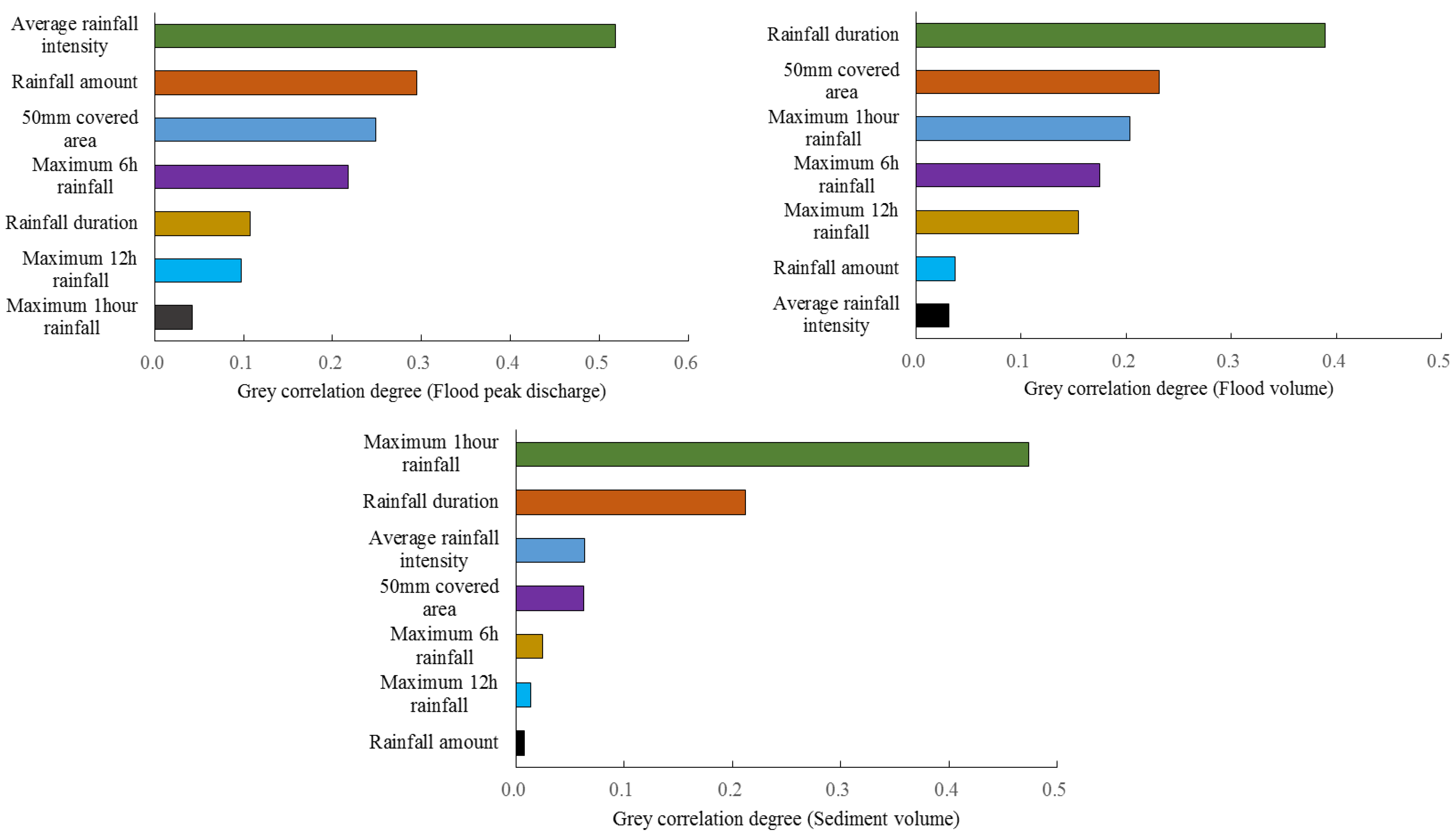
According to the grey correlation analysis results of the rainfall factors and flood factors in the Wuding River Basin (Table 1), for the factors influencing the peak flood discharge, the grey correlation degrees of the rainfall factors were found to be as follows: average rainfall intensity > amount of rainfall > 50 mm covered area > maximum 6 h rainfall > rainfall duration > maximum 12 h rainfall > maximum 1 h rainfall. The rainfall characteristic factor that had the greatest impact on the peak flood discharge was the average rainfall intensity. For the factors influencing the flood volume, the grey correlation degrees of the rainfall factors were found to be as follows: rainfall duration > 50 mm covered area > maximum 1 h rainfall > maximum 6 h rainfall > maximum 12 h rainfall > amount of rainfall > average rainfall intensity. The rainfall factor that had the greatest impact on the flood volume was the rainfall duration. For the factors influencing the sediment volume, the grey correlation degrees of the rainfall factors were found to be as follows: maximum 1 h rainfall > rainfall duration > average rainfall intensity > 50 mm covered area > maximum 6 h rainfall > maximum 12 h rainfall > amount of rainfall. The rainfall factor with the greatest impact on the sediment volume was the maximum 1 h rainfall (Figure 2). These results show that the flood factors are closely related to the rainfall factors, and the different rainfall factors have different driving effects on the different flood factors.

3.2. Analysis of the Relationship between Heavy Rainfall and Flash Floods

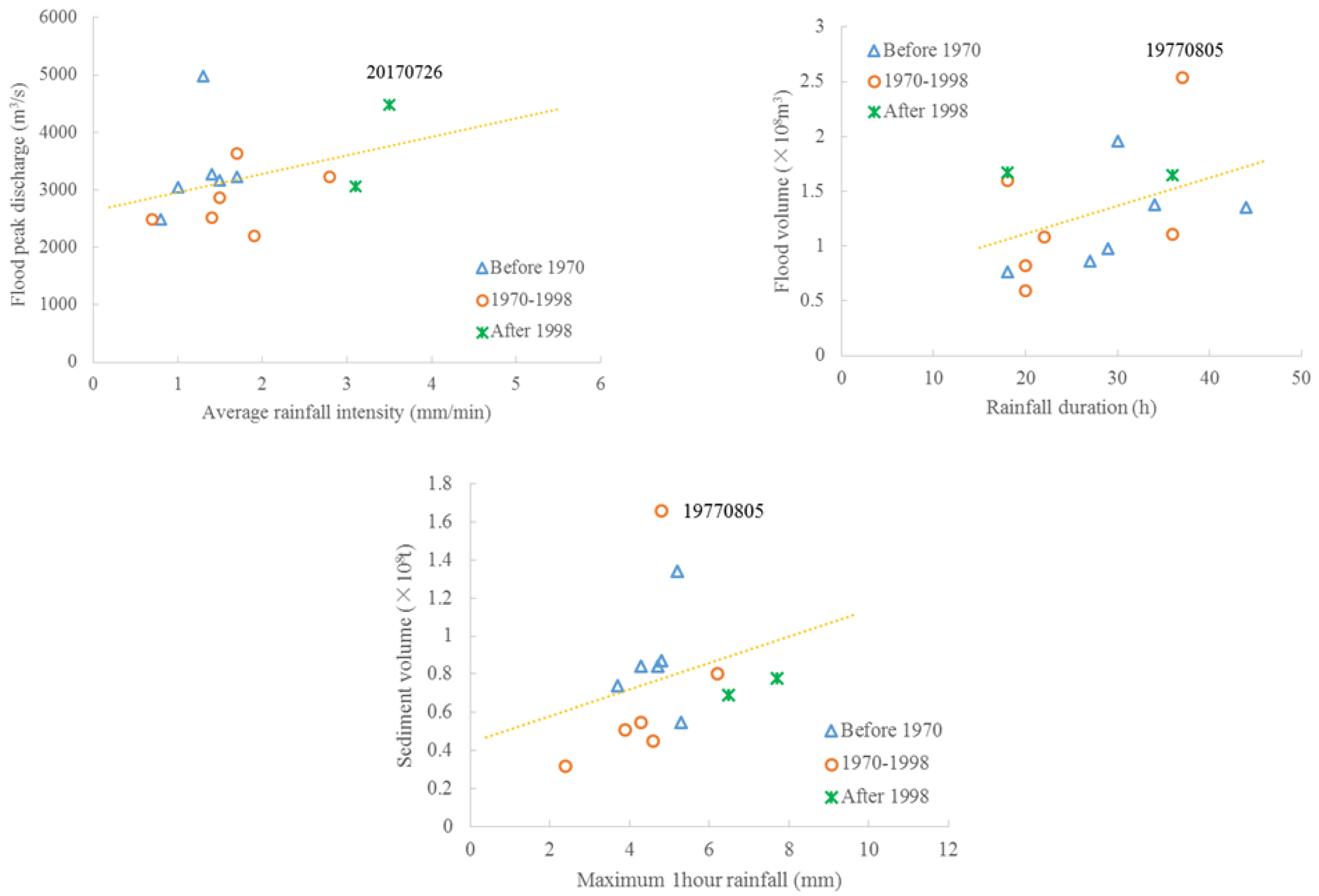
According to the selected key rainfall factors affecting flash floods, the relationship between the heavy rainfall and flash floods in the Wuding River Basin was further analyzed. The large-scale water and soil conservation projects conducted in the Wuding River Basin began in 1970. Therefore, it is generally considered that the basin conditions before 1970 were natural conditions, and the water and sediment data measured at the hydrological stations were not affected by the water and soil conservation measures. In order to further curb the soil erosion, a large-scale Grain for Green Project was implemented in 1998. As a result, a large amount of sloping farmland has been converted into forest and grassland, and the vegetation coverage has been greatly improved. Therefore, in this study, 1970 and 1998 were taken as two key time nodes, and the 13 floods recorded at Baijiachuan Station were divided into three stages (before 1970, 1970–1998, and after 1998). Then, the average rainfall intensity-peak flood flow, rainfall duration-flood volume, and maximum 1 h rainfall–sediment volume relationships were analyzed.
Based on the analysis results for the heavy rainfall–flash floods relationship in the Wuding River Basin (Figure 3), for the relationship between the average rainfall intensity and the peak flood flow, the distributions of the data points were significantly different before and after 1970. Before 1970, the distribution of the data point was larger, and the peak flood discharge driven by the average rainfall intensity was higher. After 1970, the distribution of the data points was smaller, and the peak flood discharge driven by the average rainfall intensity was smaller, which shows that the large-scale ecological construction related to the soil and water conservation projects has had a large impact on the relationship between the average rainfall intensity and the peak flood discharge. For the relationship between the rainfall duration and flood volume, the data point distributions were different before and after 1998. Before 1998, the distribution of the data point was smaller, and the flood volume driven by the rainfall duration was relatively small. After 1998, the distribution of the data points was larger, and the flood volume driven by the rainfall duration was relatively large, which shows that the Grain for Green Project has had a great impact on the relationship between the rainfall duration and flood volume. For the relationship between the sediment volume and the maximum 1 h rainfall, the distribution of the data points before and after 1970 were obviously different. Before 1970, the distribution of the data points was larger, and the sand volume driven by the maximum 1 h rainfall was larger. After 1970, the distribution of the data points was smaller, and the sediment volume driven by the maximum 1 h rainfall was relatively small, which shows that the large-scale ecological construction related to the soil and water conservation projects has had a large impact on the relationship between the maximum 1 h rainfall and the sediment volume. The above analysis indicates that the ecological construction related to the water conservation measures has had a significant impact on the peak flood discharge under high-intensity rainfall and the sediment volume under heavy rainfall, and the Grain for Green Project has had a large impact on the flood volume under long-term rainfall.
It should be noted that the peak discharge of the 7.26 flood in the Wuding River Basin in 2017 was 4480 m3/s, which is much higher than the overall change trend of the average rainfall intensity–peak flood discharge relationship. Similarly, the 8.05 flood in 1977 had a flood volume of 254 million m3 and a sediment volume of 166 million t, which are much higher than the overall change trend of the rainfall duration-flood volume and maximum 1 h rainfall–sediment volume relationships. Both these floods occurred after 1970, which shows that the soil and water conservation measures implemented on the Loess Plateau have had a good effect on reducing flooding and the sediment load under moderate- and low-intensity rainfall, but these measures have been less effective at reducing flooding and the sediment load under high-intensity rainfall.

3.3. Comparison of Typical Rainfall and Flash Floods in the Wuding River Basin

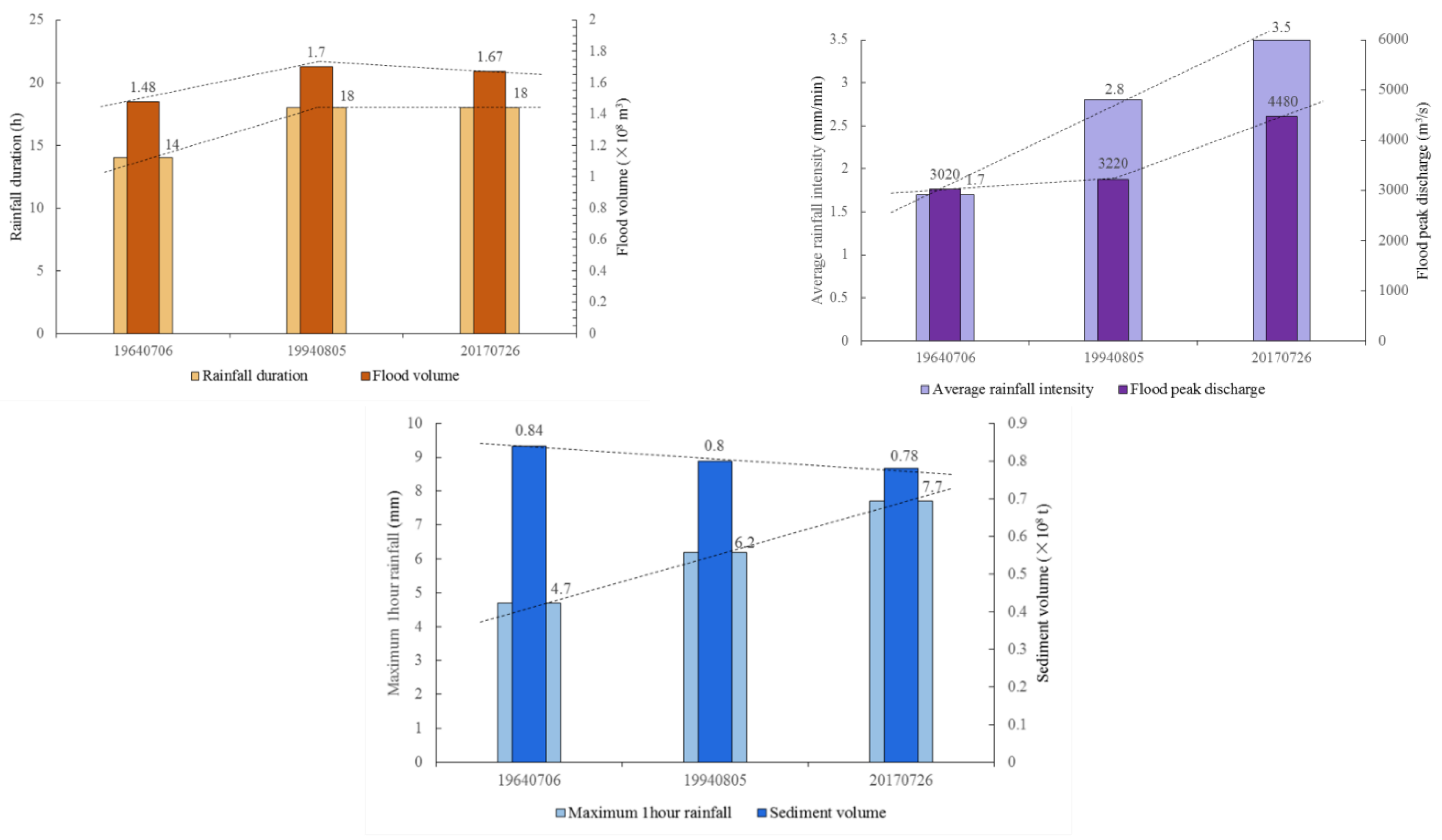
In order to further analyze the relationship between rainstorms and mountain torrents before and after the implementation of large-scale soil and water conservation projects and the Grain for Green Project in Wuding River Basin, three typical rainfall and flood processes recorded at Baijiachuan station (before 1970, 1970–1998, and after 1998) were selected for comparative analysis. The identification numbers of these three events are 19,640,706, 19,940,805, and 20,170,726, respectively.
The nested histograms of the average rainfall intensity–peak flood flow, rainfall duration-flood volume, and maximum 1 h rainfall–sediment volume relationships of the three typical floods are shown in Figure 4. As can be seen from the histogram of the average rainfall intensity and peak flood discharge, the average rainfall intensities of rainfall events 19,640,706 and 19,940,805 were quite different (1.7 and 2.8 mm/min, respectively), but their peak flood discharges were similar (3020 and 3220 m3/s, respectively). This indicates that the ecological construction related to the soil and water conservation projects had an obvious peak cutting effect on the flood processes caused by these two rainfall events. As can be seen from the rainfall duration–flood volume histogram, the change trends of the flood volumes of the three flood processes caused by rainfall events 19,640,706, 19,940,805, and 20,170,726 were similar to those of the rainfall durations, indicating that the ecological construction related to the soil and water conservation projects and the Grain for Green Project did not have a significant impact on the flood volume caused by these three rainfall events. As can be seen from the maximum 1 h rainfall–sediment volume histogram, the maximum 1 h rainfalls of rainfall events 19,640,706, 19,940,805, and 20,170,726 were 4.7, 6.2, and 7.7 mm, respectively, whereas the sediment volumes during the floods caused by these rainfall events were 0.84, 0.80, and 78 million t, respectively. It can be seen that the sediment volume produced by the significant increase in the maximum 1 h rainfall decreased slowly, and the two change trends are opposite, indicating that the ecological construction related to the soil and water conservation projects and the Grain for Green Project have significantly reduced the sediment loads during the floods caused by these three rainfall events.

4. Conclusions

In this study, the characteristics of the main driving factors of heavy rainfall that caused flash floods in the middle reaches of the Yellow River were analyzed. Taking Baijiachuan hydrological station on the Wuding River as a representative station, the rainfall events corresponding to 13 floods with peak flows of greater than 2000 m3/s since the measurements at Baijiachuan hydrological station began were selected for comparative analysis.
Through grey correlation analysis of the rainfall factors and flood factors, it was found that the different rainfall factors were the major driving factors of the different flood factors. Among them, the average rainfall intensity had the greatest impact on the peak flood discharge; the rainfall duration had the greatest impact on the flood volume; and the maximum 1 h rainfall had the greatest impact on the sediment volume. Through analysis of the relationship between the heavy rainfall and flash floods, it was found that the ecological construction related to soil and water conservation projects has had a significant impact on the peak flood discharge and sediment volume under high-intensity rainfall, and the Grain for Green Project has had a large impact on the flood volume under long-term rainfall. Through comparison of three typical heavy rainfall events that caused flash floods in the Wuding River Basin, it was found that the ecological construction related to soil and water conservation projects has had an obvious peak cutting effect and sediment reduction effect on the flood processes.
In addition, it was found that the soil and water conservation measures implemented on the Loess Plateau have had a salutary effect on reducing floods and the sediment load under medium- and low-intensity rainfall, but they have been less effective under high-intensity rainfall. Therefore, against the background of the continuous improvement of the Loess Plateau’s ecology, there is still a possibility of high-sediment floods occurring in the middle reaches of the Yellow River.

Author Contributions

P.Z.: Writing the manuscript draft, data preparation, experiments, and analysis; W.S.: data collection and supervision; P.X.: experiments and analysis; W.Y.: conceptualization and supervision; G.L.: review and editing. All authors have read and agreed to the published version of the manuscript.

Funding

This research was funded by the National Natural Science Foundation of China (Grant number 42041006, U2243210), the Natural Science Foundation of Henan Province of China (Grant number 212300410060), and Water Conservancy Science and Technology Research Project in Henan Province (GG202149).

Data Availability Statement

The datasets generated during the current study are available from the corresponding author on reasonable request.

Conflicts of Interest

The authors declare no conflict of interest.

References

  1. Miao, Q.; Yang, D.; Yang, H.; Li, Z. Establishing a rainfall threshold for flash flood warnings in China’s mountainous areas based on a distributed hydrological model. J. Hydrol. 2016, 541, 371–386. [Google Scholar] [CrossRef]
  2. Shen, Y.; Pan, Y.; Yu, J.J.; Zhao, P.; Zhou, Z.J. Quality assessment of hourly merged precipitation product over China. Trans. Atmos. Sci. 2013, 36, 37–46. (In Chinese) [Google Scholar]
  3. Duan, J.; Liu, Y.J.; Yang, J.; Tang, C.J.; Shi, Z.H. Role of groundcover management in controlling soil erosion under extreme rainfall in citrus orchards of southern China. J. Hydrol. 2020, 582, 124290. [Google Scholar] [CrossRef]
  4. Easterling, D.R.; Meehl, G.A.; Parmesan, C.; Changnon, S.A.; Karl, T.R.; Mearns, L.O. Climate extremes: Observations, modeling, and impacts. Science 2000, 289, 2068–2074. [Google Scholar] [CrossRef] [Green Version]
  5. Wei, W.; Chen, L.D.; Fu, B.J. Effects of rainfall change on water erosion processes in terrestrial ecosystems: A review. Prog. Phys. Geogr. 2009, 33, 307–318. [Google Scholar] [CrossRef]
  6. Vallebona, C.; Pellegrino, E.; Frumento, P.; Bonari, E. Temporal trends in extreme rainfall intensity and erosivity in the Mediterranean region: A case study in southern Tuscany, Italy. Clim. Chang. 2015, 128, 139–151. [Google Scholar] [CrossRef]
  7. Sarhadi, A.; Soulis, E.D. Time-varying extreme rainfall intensity-duration-frequency curves in a changing climate. Geophys. Res. Lett. 2017, 44, 2454–2463. [Google Scholar] [CrossRef]
  8. Sharma, S.; Mujumdar, P.P. On the relationship of daily rainfall extremes and local mean temperature. J. Hydrol. 2019, 572, 179–191. [Google Scholar] [CrossRef]
  9. Razavi, S.; Gober, P.; Maier, H.R.; Brouwer, R.; Wheater, H. Anthropocene flooding: Challenges for science and society. Hydrol. Process. 2020, 34, 1996–2000. [Google Scholar] [CrossRef] [Green Version]
  10. Arent, D.J.; Tol, R.S.J.; Faust, E.; Hella, J.P.; Kumar, S.; Strzepek, K.M.; T’oth, F.L.; Yan, D. Key economic sectors and services. In Climate Change 2014: Impacts, Adaptation, and Vulnerability. Part A: Global and Sectoral Aspects; Contribution of Working Group II to the Fifth Assessment Report of the Intergovernmental Panel on Climate Change; Cambridge University Press: Cambridge, UK, 2014; pp. 659–708. [Google Scholar]
  11. Wasko, C.; Sharma, A.; Pui, A. Linking temperature to catastrophe damages from hydrologic and meteorological extremes. J. Hydrol. 2021, 602, 126731. [Google Scholar] [CrossRef]
  12. Wieczorek, G.F.; Glade, T. Climatic factors influencing occurrence of debris flow. In Debris-Flow Hazards and Related Phenomena; Jakob, M., Hungr, O., Eds.; Springer: Berlin/Heidelberg, Germany, 2005; pp. 325–362. [Google Scholar]
  13. Li, F.; Zhang, Y.; Xu, Z.; Teng, J.; Liu, C.; Liu, W.; Mpelasoka, F. The impact of climate change on runoff in the southeastern Tibetan Plateau. J. Hydrol. 2013, 505, 188–201. [Google Scholar] [CrossRef]
  14. Wang, H.; Yang, Z.; Saito, Y.; Liu, J.P.; Sun, X.; Wang, Y. Stepwise decreases of the Huanghe (Yellow River) sediment load (1950–2005): Impacts of climate change and human activities. Glob. Planet. Change. 2007, 57, 331–354. [Google Scholar] [CrossRef]
  15. Gao, T.; Xie, L. Multivariate regression analysis and statistical modeling for summer extreme rainfall over the Yangtze River basin, China. Adv. Meteorol. 2014, 1, 269059. [Google Scholar]
  16. Li, P.; Xu, G.C.; Lu, K.C.; Zhang, X.M.; Shi, P.; Bai, L.L. Runoff change and sediment source during rainstorms in an ecologically constructed watershed on the loess plateau, China. Sci. Total Environ. 2019, 664, 968–974. [Google Scholar] [CrossRef]
  17. Yuan, M.; Zhang, Y.; Zhao, Y.; Deng, J. Effect of rainfall gradient and vegetation restoration on gully initiation under a large-scale extreme rainfall event on the hilly Loess Plateau: A case study from the Wuding River basin, China. Sci. Total Environ. 2020, 739, 140066. [Google Scholar] [CrossRef]
  18. Han, J.; Gao, J.; Luo, H. Changes and implications of the relationship between rainfall, runoff and sediment load in the Wuding River basin on the Chinese Loess Plateau. Catena 2019, 175, 228–235. [Google Scholar] [CrossRef]
  19. Wei, W.; Chen, D.; Wang, L.; Daryanto, S.; Chen, L.; Yu, Y.; Lu, Y.; Sun, G.; Feng, T. Global synthesis of the classifications, distributions, benefits and issues of terracing. Earth Sci. Rev. 2016, 159, 388–403. [Google Scholar] [CrossRef] [Green Version]
  20. Wang, S.; Fu, B.; Piao, S.; Lü, Y.; Ciais, P.; Feng, X.; Wang, Y. Reduced sediment transport in the Yellow River due to anthropogenic changes. Nat. Geosci. 2015, 9, 38–41. [Google Scholar] [CrossRef]
  21. Wang, F.; Hessel, R.; Mu, X.; Maroulis, J.; Zhao, G.; Geissen, V.; Ritsema, C. Distinguishing the impacts of human activities and climate variability on runoff and sediment load change based on paired periods with similar weather conditions: A case in the Yan River, China. J. Hydrol. 2015, 527, 884–893. [Google Scholar] [CrossRef]
  22. Yang, X.; Sun, W.; Li, P.; Mu, X.; Gao, P.; Zhao, G. Reduced sediment transport in the Chinese Loess Plateau due to climate change and human activities. Sci. Total Environ. 2018, 642, 591–600. [Google Scholar] [CrossRef]
  23. Hou, T.; Kong, F.; Chen, X.; Lei, H. Impact of 3DVAR data assimilation on the prediction of heavy rainfall over Southern China. Adv. Meteorol. 2013, 3, 129642. [Google Scholar] [CrossRef] [Green Version]
  24. Zhu, J.; Kong, F.; Lei, H. A regional ensemble forecast system for stratiform precipitation events in the Northern China Region. Part II: Seasonal evaluation for summer 2010. Adv. Atmos. Sci. 2013, 30, 15–28. [Google Scholar] [CrossRef]
  25. Wasko, C.; Nathan, R.; Stein, L.; O’Shea, D. Evidence of shorter more extreme rainfalls and increased flood variability under climate change. J. Hydrol. 2021, 603, 126994. [Google Scholar] [CrossRef]
  26. Liu, Y.J.; Yang, J.; Hu, J.M.; Tang, C.J.; Zheng, H.J. Characteristics of the surface–subsurface flow generation and sediment yield to the rainfall regime and landcover by long-term in-situ observation in the red soil region, Southern China. J. Hydrol. 2016, 539, 457–467. [Google Scholar] [CrossRef]
  27. Higley, M.C.; Conroy, J.L. The hydrological response of surface water to recent climate variability: A remote sensing case study from the central tropical Pacific. Hydrol. Processes 2019, 33, 2227–2239. [Google Scholar] [CrossRef]
  28. Ran, Q.; Zong, X.; Ye, S.; Gao, J.; Hong, Y. Dominant mechanism for annual maximum flood and sediment events generation in the Yellow River basin. Catena 2020, 187, 104376. [Google Scholar] [CrossRef]
  29. Wei, W.; Chen, L.D.; Fu, B.J.; Lü, Y.H.; Gong, J. Responses of water erosion to rainfall extremes and vegetation types in a loess semiarid hilly area, NW China. Hydrol. Processes 2009, 23, 1780–1791. [Google Scholar] [CrossRef]
  30. Wang, L.J.; Zhang, G.H.; Wang, X.; Li, X.Y. Hydraulics of overland flow influenced by litter incorporation under extreme rainfall. Hydrol. Processes. 2018, 33, 737–747. [Google Scholar] [CrossRef]
  31. Farsi, N.; Mahjouri, N. Evaluating the contribution of the climate change and human activities to runoff change under uncertainty. J. Hydrol. 2019, 574, 872–891. [Google Scholar] [CrossRef]
  32. Solano-Rivera, V.; Geris, J.; Granados-Bolaños, S.; Brenes-Cambronero, L.; Artavia-Rodríguez, G.; Sánchez-Murillo, R.; Birke, C. Exploring extreme rainfall impactson flow and turbidity dynamics in a steep, pristine and tropical volcanic catchment. Catena 2019, 182, 104–118. [Google Scholar] [CrossRef]
  33. Zhang, Y.; Zhao, Y.Y.; Liu, B.Y.; Wang, Z.Q.; Zhang, S. Rill and gully erosion on unpaved roads under heavy rainfall in agricultural watersheds on China’s Loess Plateau. Agric. Ecosyst. Environ. 2019, 284, 106580. [Google Scholar] [CrossRef]
  34. Jin, L.; Wang, C.; Wang, P.; Guo, T. Analysis of characteristics of the extreme precipitation in the Yellow river basin. J. Water Resourc. Water Eng. 2016, 6, 44–48. (In Chinese) [Google Scholar]
  35. Mustafa, A.; Szydłowski, M. The impact of spatiotemporal changes in land development (1984–2019) on the increase in the runoff coefficient in Erbil, Kurdistan Region of Iraq. Remote Sens. 2020, 12, 1302. [Google Scholar] [CrossRef] [Green Version]
  36. Fofana, M.; Adounkpe, J.; Larbi, I.; Hounkpe, J.; Djan’na Koubodana, H.; Toure, A.; Bokar, H.; Dotse, S.-Q.; Limantol, A.M. Urban flash flood and extreme rainfall events trend analysis in Bamako, Mali. Environ. Chall. 2022, 6, 100449. [Google Scholar] [CrossRef]
  37. Borga, M.; Boscolo, P.; Zanon, F.; Sangati, M. Hydrometeorological analysis of the 29 August 2003 flash flood in the Eastern Italian Alps. J. Hydrometeorol. 2007, 8, 1049–1067. [Google Scholar] [CrossRef]
  38. Liu, Y.; Fu, B.J.; Lv, Y.; Wang, Z.; Gao, G. Hydrological responses and soil erosion potential of abandoned cropland in the Loess Plateau, China. Geomorphology 2012, 138, 404–414. [Google Scholar] [CrossRef]
  39. Zhao, Y.; Cao, W.; Hu, C.; Wang, Y.; Wang, Z.; Zhang, X.; Zhu, B.; Cheng, C.; Yin, X.; Liu, B.; et al. Analysis of changes in characteristics of flood and sediment yield in typical basins of the Yellow River under extreme rainfall events. Catena 2019, 177, 31–40. [Google Scholar] [CrossRef]
  40. Xu, Z.; Zhang, S.; Yang, X. Water and sediment yield response to extreme rainfall events in a complex large river basin: A case study of the Yellow River Basin, China. J. Hydrol. 2021, 597, 126183. [Google Scholar] [CrossRef]
  41. Abolverdi, J.; Ferdosifar, G.; Khalili, D.; Kamgar-Haghighi, A.A. Spatial and temporal changes of precipitation concentration in Fars province, southwestern Iran. Meteorol. Atmos. Phys. 2016, 128, 181–196. [Google Scholar] [CrossRef]
  42. Wei, W.; Chen, L.; Fu, B.; Huang, Z.; Wu, D.; Gui, L. The effect of land uses and rainfall regimes on runoff and soil erosion in the semi-arid loess hilly area, China. J. Hydrol. 2007, 335, 247–258. [Google Scholar] [CrossRef]
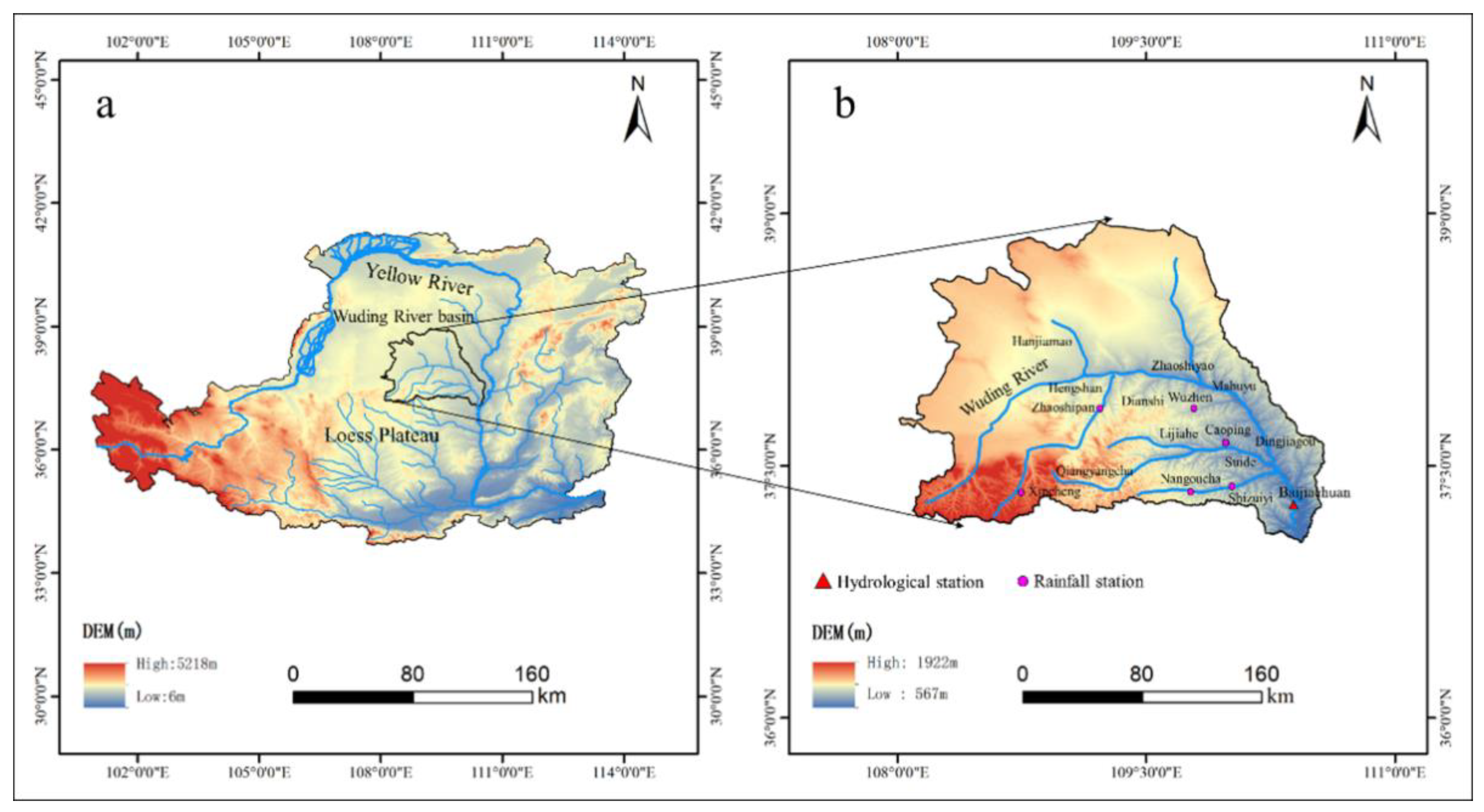
Figure 1. General conditions in the Wuding River Basin, China: (a) Location of the study area; and (b) selected hydrological stations, rainfall stations, and elevation distribution.
Sustainability 14 08004 g001
Figure 2. Grey correlation ranking between rainfall factors and flood factors in the Wuding River Basin.
Sustainability 14 08004 g002
Figure 3. The relationship between heavy rainfall and flash floods in the Wuding River Basin.
Sustainability 14 08004 g003
Figure 4. Nested histograms of the key rainfall factors and flood factors of three typical floods in the Wuding River Basin.
Sustainability 14 08004 g004
Table 1. Grey correlation degrees between the rainfall factors and flood factors in the Wuding River Basin.
Flood FactorsRainfall Characteristic Factors
Rainfall DurationAmount of Rainfall Average Rainfall IntensityMaximum 1 h RainfallMaximum 6 h RainfallMaximum 12 h Rainfall50 mm Covered Area
(h)(mm)(mm/min)(mm/min)(mm)(mm)(km2)
Peak flood discharge0.1070.2940.5180.0420.2180.0980.248
Flood volume0.3890.0370.0320.2040.1750.1550.232
Sediment volume0.2120.0020.0630.4740.0240.0140.062
Publisher’s Note: MDPI stays neutral with regard to jurisdictional claims in published maps and institutional affiliations.