Article

Sustainable Land Use and Livelihood Dynamics in Henan County on the Qinghai–Tibet Plateau—A Transdisciplinary Systems Perspective

1
Department of Agribusiness and Markets, Faculty of Agribusiness and Commerce, Lincoln University, Lincoln 7647, New Zealand
2
Department of Land Management and Systems, Faculty of Agribusiness and Commerce, Lincoln University, Lincoln 7647, New Zealand
3
College of Agriculture and Animal Husbandry, Qinghai University, Xining 810016, China
*
Author to whom correspondence should be addressed.
Sustainability 2022, 14(13), 7785; https://doi.org/10.3390/su14137785
Submission received: 27 May 2022 / Revised: 23 June 2022 / Accepted: 23 June 2022 / Published: 26 June 2022

Abstract

:
Since the 1950s, Henan County on the Qinghai–Tibet Plateau (the Plateau) has experienced notable changes in its ecological and socio-economic environments, posing challenges to livelihood sustainability. Adopting a mixed method of qualitative interviews, field observations, and statistical data analysis, these changing livelihoods were investigated from a transdisciplinary systems perspective. The aim of this research was to develop an understanding of the relationships between changing land use and the livelihood dynamics on an ecologically fragile land. Results indicate that increasing human and animal populations, together with increasing connectivity between the Plateau and the lowlands, have led to increasing flows of nutrients to the lowlands. The increasing product flows, including the use of dung which is used for heating both on the Plateau and as a Plateau export, together with a lack of nutrients returning to the grasslands, have contributed to the present sustainability challenges. In this study, the transdisciplinary systems perspective provides an overarching integrative framework that transcends the individual socio-economic and biophysical system components, thereby providing key insights not available from within individual disciplines. More detailed analyses are now required, still within a transdisciplinary framework, to quantify specific relationships.

1. Introduction

With 42% of the world’s population depending on agriculture for its livelihood, sustainable land use in agriculture has been a focal point of scholarly endeavours in recent decades [1]. This is particularly the case for ecologically fragile regions, such as the Qinghai–Tibet Plateau (the Plateau) in western China [2]. The present study took place within this fragile landscape, in Henan County of Huangnan Prefecture in Qinghai Province. The nexus of its location, history, traditions, and more recent land use policy changes, along with the growing concerns surrounding environmental deterioration, have made Henan County a unique place to provide rich insights into the sustainable land use and livelihood dynamics within high–altitude fragile grasslands on the Qinghai–Tibet Plateau.

1.1. The Contextual Background

Many previous studies of the Qinghai–Tibet Plateau have focused on specific aspects of rangeland ecology and have documented widespread environmental degradation [2,3,4,5,6,7,8,9]. However, there have only been limited accounts of pastoral livelihoods on the Qinghai–Tibet Plateau [8,10,11], with these being historical and not from within the Sanjiangyuan region, the significance of which is further explained below. More recently, there is an emerging stream of policy-focused literature relating to environmental implications, including climate-change issues, of alternative use rights and grazing management systems [12,13,14,15,16]. However, we were unable to find studies from anywhere on the Qinghai–Tibet Plateau that considered the inter-relationships between the natural ecology and the social dynamics of the farmers’ livelihoods from a transdisciplinary systems perspective.
Henan County is located close to the northeast corner of the Qinghai–Tibet Plateau in the headwaters of the Yellow River (Figure 1).
The Qinghai–Tibet Plateau, also commonly known as the Tibetan Plateau, is the highest and largest plateau in the world [18]. In China, it is referred to as 青藏高原 (Qing Zang Gao Yuan, or Qinghai–Tibet Plateau). It spans 31 degrees of longitude, and nearly 13 degrees of latitude, covering almost 2.6 million km2 (260 million hectares), which is just over a quarter of the land area of China [19]. Covering about 42% of China’s total rangeland area, most of the 168 million hectares of rangeland on the Plateau is above 3500 m elevation. Except in the most southern latitudes, it is typically too cold for crop cultivation [18,20].
Administratively within China, the Qinghai–Tibet Plateau covers most of the Tibet Autonomous Region, plus the majority of Qinghai Province (of which the capital city is Xining, at intermediate altitudes below the Plateau itself, at approximately 2200 m elevation), and small parts of Xinjiang Uygur Autonomous Region, Gansu Province, Sichuan Province and Yunnan Province. The Qinghai–Tibet Plateau is the source of four major rivers on the Eurasian Continent. These are the Yellow River, the Yangtze River, the Mekong River (known as the Lancang River for its part in China), and the Brahmaputra River (known as the Yarlung Zangbo River for its part in Tibet). Three of these rivers (the Yellow, the Yangtze, and the Mekong) have their sources located within Qinghai Province.
The significance of these rivers to China and the vulnerable ecosystems around the areas where these three rivers originate has led to the establishment by the Chinese Central Government of the Sanjiangyuan National Nature Reserve (三江源自然保护区), also known as the Sanjiangyuan Region, meaning Three Rivers Headwaters Region. This region occupies the southern 43% of the land area of Qinghai Province, covering four prefectures, totalling 302,500 km2 (30.25 million hectares) [21]. The research focus, Henan County, encompasses 6700 km2 (670,000 hectares) within this Sanjiangyuan Region. Being the largest and most elevated natural reserve in China, and given the importance that the ecology of the region is perceived to have, the Government has mandated agricultural land-use within the entire Sangjiangyuan Region to be exclusively dedicated to organic agricultural and/or pastoral production. This designation prevents the use of chemical fertilisers and sprays, thereby constraining many modern agricultural practices. Additionally, cropping is not permitted, unless it is direct drilling in small areas for growing of winter supplements such as barley.
Much of Qinghai Province, together with small parts of Sichuan and Gansu Provinces, make up the area of Amdo, one of the three major ethno-linguistic regions of the Plateau [11]. Together with Ü-Tsang and Kham, these three traditional regions make up all of the Plateau (Figure 2).
Despite having three distinctive traditional regions, there is a relatively uniform language and culture on the Qinghai–Tibet Plateau. The vast majority of the people on the Plateau are Tibetans in ethnicity, and speak the Tibetan language with dialectic variations [20].
Natural pastures on the Plateau are the dominant land category below the permanent snow line and have for millennia until recently supported traditional nomadic pastoralism [23]. The focus area of this research, Henan County, is no exception to this.
Henan County, at around 3600 m elevation, is one of the five counties within Huangnan Tibetan Autonomous Prefecture, which is one of the six administrative areas (prefectures or cities) within Qinghai Province (Figure 3). Administratively, Henan is classed as a Mongolian Autonomous County, reflecting links back to a Mongolian invasion and associated migration from the north approximately 800 years ago. To reach Henan County from the capital city of Qinghai Province, Xining city, one needs to drive about 300 km south, including crossing a mountain pass several hundred metres in elevation to get onto the adjacent Zeku County on the Plateau. Beyond the mountain pass there are no trees. Before modern civilisations reached the Plateau, the lowlands were essentially separated from the uplands by the absence of easily navigable connecting trails.

1.2. The History

The early history reported here relies heavily on the Chinese language document of Cairang [25], with additional information from a few scholarly articles investigating the marginalisation of ethnic minorities in China, which included both Chinese and Tibetan literature in their research [26,27].
Henan County is also known as Malho or Sogpo, which are Tibetan words for Mongolian [26]. Although the history of Mongolian occupation on the Qinghai–Tibet Plateau traces back to 1227 of the Yuan Dynasty, Henan County represents the only remaining community identified as Mongolian on the Plateau. Prior to the Mongolian occupation, the Plateau was ruled under its own kingdom with periods of division and unity. Tibetan Buddhism, which originally came from India, had also been widely adopted on the Plateau by that time [25].
The Yellow River originates on the Plateau within Qinghai province, then meanders northeast with several major curves, including flowing into Gansu Province and then back into Qinghai Province. It then flows further north and east, and eventually exits Qinghai into Gansu Province again. The several bends of the Yellow River along with multiple tributaries made this area a favoured environment for nomads due to easy access to water and pasture. Back in the days of Mongolian reign over the Plateau, Mongols came from north of the Plateau, and occupied first the north side of the Yellow River. Subsequently, a branch of Mongols crossed over to south of the main branch of the Yellow River during the season when it froze over (This coincided with the time of “Little Ice Age”, when low global temperatures were recorded). The name Henan (“He” 河: River and “Nan” 南: South) was a name given to the place by the Mongols where they occupied south of the main branch of the Yellow River. Over the centuries of Mongolian influence on the Plateau, Mongols gradually lost their authority over the rangeland, except this group living in the south of the Yellow River. However, the influence on the rangeland of this southern Mongolian group has also been reduced over time, and eventually limited to what is now Henan County [25].
Through the years of turmoil in China when western colonisation and later warlords were battling for territories, the Mongolian communities on the Plateau also had their periods of settlement and upheaval. This changed in September 1949, when the then Mongolian Prince in Henan agreed to the People’s Liberation Army entering Henan after the neighbouring area in Gansu Province had been liberated. Then in 1954, Henan Mongolian Autonomous County was officially established, under the administration of Qinghai Province and the current Chinese Central Government [25]. At that time, and following the National Ethnic Classification Project, the inhabitants of Henan took the opportunity to formalise their Mongol status and hence differentiate themselves from the surrounding Tibetans [27].
Despite the formal classification of Henan, in reality the long history of Mongol–Tibetan interaction had brought about cultural and social integration between the two ethnicities. The current Mongolian language was developed in the 1270s based on the Tibetan alphabet [25], and no one knows when the majority of Mongols in Henan lost their own language and began speaking Tibetan [27]. Indeed, during the visits to Henan County for the present research, the phrase “Mongols and Tibetans are one family (“meng zang yi jia”, 蒙藏一家)” was often talked about by many.

1.3. Traditional Farming

Irrespective of which authority the Plateau was ruled under, a nomadic farming system had been maintained for many centuries up until 1959, with a relatively homogeneous Tibetan Buddhist culture and customs shared across the Plateau. In more recent centuries, the allocation of land to specific groups was determined within a feudal system controlled by the Dalai Lama and the Panchen Lama, and their religious-politico administrations [28]. This was within an ecological context of low but slowly increasing human populations and hence similarly low but slowly increasing grazing pressure.
Before the 1950s, the nomads generally used rangelands communally, and in groups that reflected a broader communal structure. In the most common traditional livestock management systems identified by Miller [18,20,29], groups of nomads often had seasonally defined grazing land areas or territories, within which all group members had the right to herd their livestock on grazing sites at their own selection. There was also another management system, in which livestock carrying capacity for specific pastures over a large territory was determined, and then individual pastures were allocated for different seasons to households based on their livestock numbers. There was a stocktake of livestock every three years, and pastures were reallocated. Nomads whose herds had grown would be allocated more pastures, and those whose herds had shrunk would lose grazing land [18].
Miller [20] reports that each nomad family owned and took responsibility for the production and marketing of its own livestock and livestock products. Within a nomad family, the division of labour was gender specific: women were in charge of milking, milk processing, and all other tasks in and around the tent, while men carried out the work which led away from the tent, such as grazing of livestock and trading. Women were the managers of the household, making vital decisions about the use of rangeland resources, such as forage, water, and fuel. “As herders, women are responsible for many of the daily activities involving livestock production and the harvesting and/or processing of livestock products. Their decisions and actions have direct effects on rangeland resources and livestock” [20]. The seasonal migration of the entire family as well as the division of labour for animal husbandry within a family were some of the key features of a nomadic lifestyle on the Plateau [23]. Many aspects of this traditional way of life have not changed, even under the more sedentary systems of recent decades [17].
According to Manderscheid [23] and Shang, Gibb, and Long [30], the aim of pastoral activities for a nomad household on the Plateau appeared to be to increase the number of animals that they own by selling and consuming as little as possible. The motivation behind such accumulation was a pastoral strategy for the guarantee of a sufficient herd size surviving through unexpected natural disasters, such as snowstorms. Consequently, there was a perceived prestige attributed to those who owned more livestock.

1.4. Land Use Policy Changes

In the interim between the traditional systems of prior centuries and the more recent retrospective reports of those systems, there was a series of key land use policy implementations by the Chinese Central Government [4,8,10,18,20,23,31,32,33]. First, there was the “mutual-aid” programme implemented across the Plateau in 1960, as the first step towards Chinese communist-inspired communal livestock production. Then in 1966, private ownership of animals was replaced by people’s communes. This exercise of collectivisation saw all animal husbandry tasks and livestock management decisions regulated by the commune, although extensive pastoral livestock production still continued. Nomads earned “points” for work performed, and received food and necessities based on the number of points they earned [18].
This commune system lasted for approximately 15 years, but was then replaced in 1981 by the Household Responsibility System. The communal livestock were distributed equally among members, and farmers regained control over their pastoral production practices [18]. Fences were introduced to reduce quarrels over property matters. This privatisation exercise started with winter grazing lands initially, then extended to summer grazing lands since about the year 2000. Privatisation was implemented down to individual families on the Plateau in provinces of Qinghai (and hence in Henan County), Sichuan, and Gansu, but was only actioned to the level of groups of nomads in the Tibet Autonomous Region. One explanation given for this difference is that rangelands in the Tibet Autonomous Region are not as productive, and that fencing expenses would be prohibitive should privatisation be executed down to individual property level [18].

1.5. Environmental Deterioration

Part of the rationale behind the sedentarisation and privatisation processes has been a belief in “the tragedy of the commons” leading to degradation of the grasslands on the Qinghai–Tibet Plateau, with a wide consensus that the ecological conditions on the Plateau have been deteriorating [2,3,4,5,6,7]. Based on the Chinese Government’s official reports, Waldron et al. [5] note that at least 90% of China’s grassland has been reported to have various degrees of degradation. While there have been scholars questioning the credibility of data on which these statistics were based, and pointing out contradictions within and across some of the official reports, the belief of extensive grassland degradation is pervasive [3,8,34]. Research also shows that farmers are aware of such degradations. Yan et al. [7] reported on the perception of farmers regarding the state of grasslands in three counties of the source regions of the Yangtze and Yellow Rivers as “lots of rodent burrows, increase of bare areas, short grass layer, more weeds and poisonous weed, desertification of meadows”. In the present research, older interviewees were clear in their recollections that Henan County too had suffered from degradation in their lifetimes. Indicators of this were meadows with less foliage, more bare ground, and desertification.
Consequences of grassland degradation are more than just ecological sufferings, where colours of the landscape have turned dull and with biodiversity afflicted [4]. According to Yan et al. [7], the very resource that farmers’ livelihoods depend on, the pastures, can no longer offer the same carrying capacity of livestock as they used to. Within China, the causes for such degradation have been largely attributed to climate change and overgrazing [3].
Despite the criticism from some international scholars regarding these land-use policy changes [3,6,10], the belief in “the tragedy of the commons” prevails in China, and the Government continues with its sedentarisation and privatisation efforts, while offering financial support through subsidies and various settlement programmes. Endeavours have also been made by the Chinese Government through investing in artificial planting and pest eradication programmes, as they attempt to re-balance the ecology on the fragile grasslands [35,36]. Within the Sanjiangyuan Region, where Henan County is located, efforts have also been made in recent years by the Government to sedentarise farmers through resettlement (“ecological settlement”) programmes. The scheme limits the number of animals that farmers can have in relation to the land that they control, and also bans grazing of ecologically fragile areas.

2. Materials and Methods

This study focuses on the land-use practices and livelihood dynamics of herder families and the wider community in Henan County, as well as the interplay between these livelihoods and sustainability. Given the complexity of managing ecological and livelihood objectives, the overarching framework is a transdisciplinary investigation of interacting biophysical and socio-economic systems. The transdisciplinary perspective is used both to frame and interpret the realities of life within this part of the Qinghai–Tibet Plateau.
The transdisciplinary approach within this investigation reflects that the research questions relate to understanding livelihoods within a broad bio-socio-economic system, hence no individual discipline was given pre-eminence. Accordingly, a mixed-methods paradigm was adopted to investigate Henan County livelihoods comprising extant published literature, unpublished official records, and in-depth interviewing of pastoral families, together with informal discussions with people in positions of influence within the community, plus the researchers’ personal observations during multiple visits to Henan County both before and during the data-collection period.
The use of extant Chinese and English language literature was to place more recent events in the county within a broader historical context of Plateau lifestyles. Local statistical data were sourced from recent Henan County documents. For livestock numbers, we have adopted the local official calculating method, where 1 sheep unit (SU) = 1 adult sheep, lambs < 6 months = 0.4 SU, adult yaks = 4 SU, yaks < 2 years = 2.8 SU, horses = 6 SU, and foals < 1 year = 3 SU [37].
The main primary data sources were semi-structured interviews with farming families, together with opportunistic discussions with officials and businesspeople, and supplemented by researchers’ observations. The primary research was guided by inductive-led theory-building principles championed by Eisenhardt, in which the qualitative data collection is focused on the thoughts and perspectives of the informants within the contexts of actual events and memories, broadly recalled within a chronological order [38,39,40,41]. A similar methodological approach has been advocated by other rangeland researchers [42,43,44]. Thematic analysis normally follows this qualitative data collection process, with key themes emerging and the interpretive analysis thereof becoming the main research findings.
The initial investigations of this study in Henan County began in 2013, with most of the collaborative fieldwork reported in this paper being undertaken between 2015 and 2017. In total, 13 detailed semi-structured interviews were conducted with different farming families in the summers of 2015 and 2016, then with another three different farming families and one focus group (18 people) in the spring of 2017. The families were chosen opportunistically—when researchers saw a farming family on the grasslands, or smoke coming from a tent, they approached the tent and asked for permission to be interviewed. There were no refusals, and the interviews typically took place within the family’s summer tent-homes. For the focus group, the researchers’ local contacts pre-arranged a meeting time and place, and then the interview was conducted. Because the farmers speak Tibetan as their first language, a local bilingual person assisted with the interpretation from Tibetan to Chinese (Mandarin).
This primary data collection focused on local people describing the rhythms of their lives within a conversational framework, typically supplemented by how these livelihoods have changed over time, and often concluding with future aspirations for themselves and their children. Although a set of open-ended questions to guide the interviews were prepared, conversations were allowed to flow naturally, with families being asked to describe the “what, when and how” of their livelihoods, and their aspirations. Interviews were conducted in the form of a casual conversation with the focus on farmers’ livelihoods, without attempting to obtain personal information. As such, we did not inquire about farmers’ ages or their incomes. Prompts during the interviews typically followed a chronological order, asking the farmers to recount the major events during their farming careers as well as key activities with a typical yearly cycle on the farm. The interviews were undertaken without any official being present and most were recorded digitally, with subsequent transcription thereof in Chinese, then uploaded into NiVivo12 for further analysis. All fieldwork complied with the guidelines set out by Lincoln University Human Ethics Committee.
Wherever opportunities presented themselves, local officials and businesspeople were also approached for conversations. More detailed discussions were held with five of these people, who can be considered as community elites. These conversations were not recorded, but notes were taken either concurrently or immediately thereafter. Throughout the study period, many less detailed informal interactions also took place with local people, particularly around livelihood discussions.
For historical data on human and livestock populations, information was collated from county official yearbooks of Henan County. Publicly available statistics from yearbooks published by National Bureau of Statistics of China were also accessed for national and provincial statistics [45,46,47,48,49,50,51,52,53,54,55,56,57,58,59,60].

3. Results–Changes in Henan County

Interviewees in this research reported dramatic changes in Henan County during their lifetime in both ecological and socio-economic environments, extending back in some cases to the early 1960s.

3.1. The Changing Landscape

Over the decades since the 1960s, the population in Henan County has dramatically increased as have livestock numbers. There have been major improvements in infrastructure, and this has facilitated much greater exchange of goods and services with the lowlands. Animal production including per-head productivity has increased markedly despite being constrained by the harsh climate. The condition of the grasslands has deteriorated.

3.1.1. Physical Climate

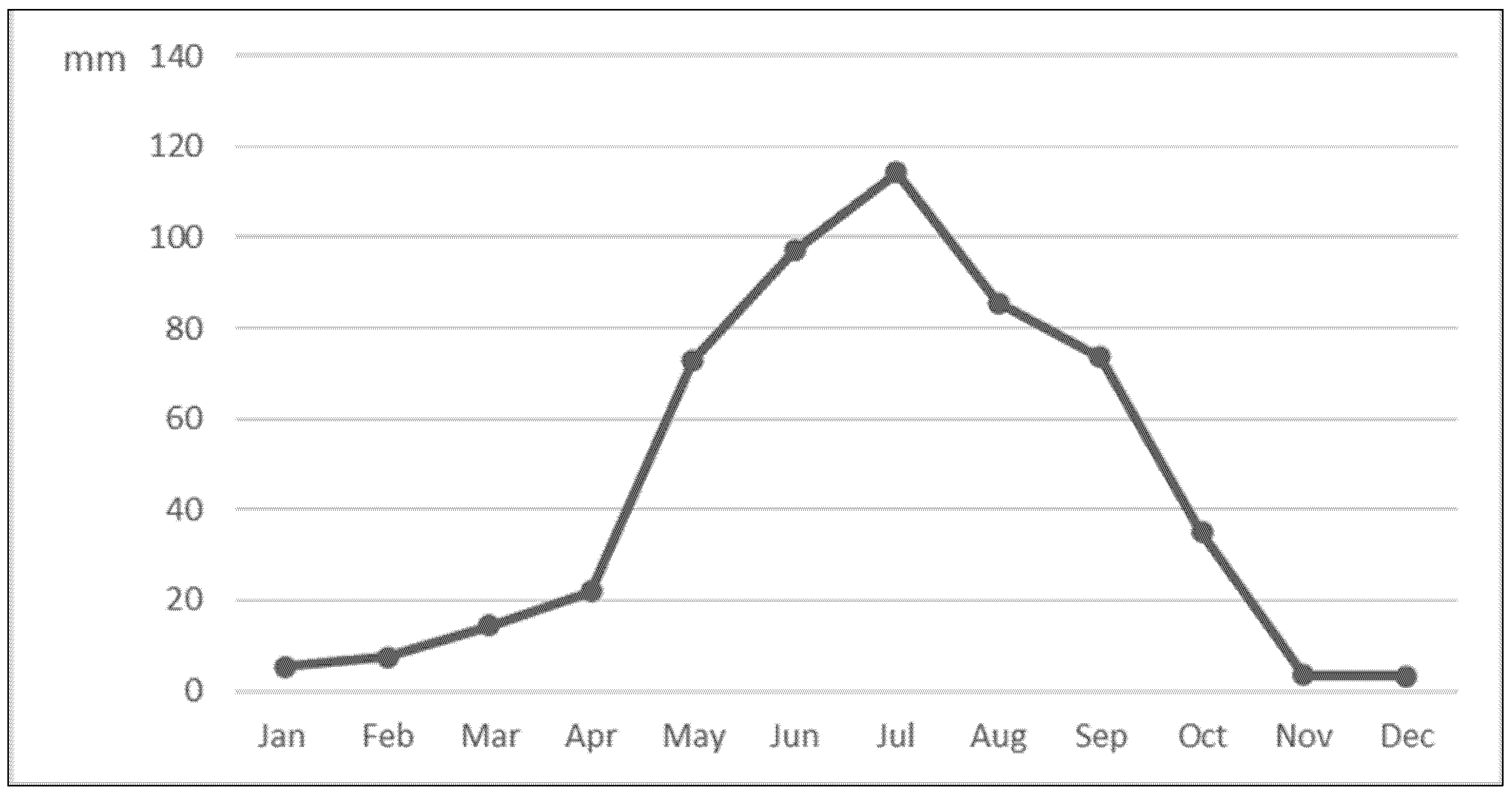
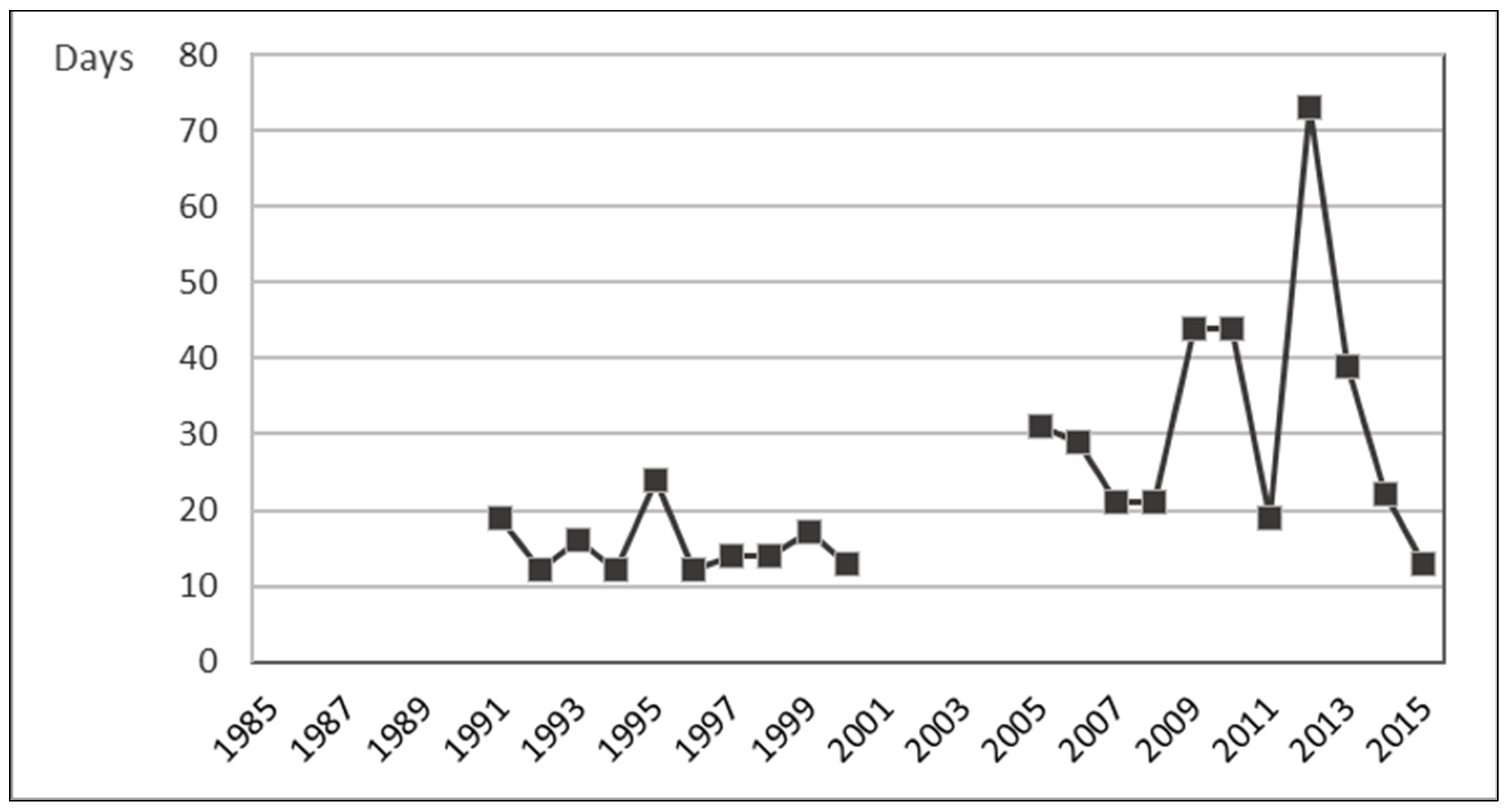
Climate data is available for 1985 and then for two periods, 1991–2000 and 2004–2015 [45,46,47,50] (Figure 4 and Figure 5). There are notable differences between the two periods but not within periods. Accordingly, one cannot confirm whether these differences are due to a data-collection site change within the county or to a step-change in conditions. Regardless as to the explanation on this point, it is evident that the climate is cold and arid. Rainfall is summer dominant (Figure 6). Frost free days averaged 15 days per annum between 1991 and 2000, and 32 days per annum between 2005 and 2015 (Figure 7). The researchers observed that during the years of their studies in Henan County, temperatures were too low to support growth of pastures until early May. Despite the low winter precipitation, soil moisture coming out of winter was apparently adequate at this time. Interviewee reports together with researcher observations were that the growing season is essentially complete by the end of August, with soil moisture being in major deficit owing to evapotranspiration exceeding summer rain. Officially recorded average annual temperatures of less than one degree Celsius (Figure 5), combined with the low number of frost-free days, confirms the overarching constraint imposed on these grassland systems by temperature compounded by aridity.

3.1.2. Demographics

According to the Henan Mongolian Autonomous County Bureau of Statistics yearbooks, the population of Henan County increased from 10,800 in 1960 to 38,596 in 2015 (Figure 8) [47,50,51]. Absolute growth numbers were approximately linear throughout this period, averaging around 500 persons per year. However, the rate of growth declined markedly over this period, averaging about 3.0% per annum in the 1960s and through to the late 1970s, but with some volatility between years, declining to around 1.0% per annum for the period 2005 to 2015. Over the total period of 55 years from 1960, the population of Henan almost quadrupled, whereas in comparison, the total population of China approximately doubled from 0.68 billion to 1.43 billion [61]. The likely explanation for the much faster population growth rate in Henan compared to the national population increase in China lies in the national One Child Policy not being applied to many ethnic minorities of China [62]. This situation was confirmed by the interviewees in relation to Henan.
Although more detailed demographic data were available to us, the specific information available changed over time and there were also periods for which there were no data. Accordingly, the information that follows reflects this situation.
The urban population (six towns) comprised 15% of the county population in 1985, declining to 14.7% in 2000, and increasing to 16.5% in 2015 [46,50]. Caution should be taken that the Chinese “hukou” (户口, household registration) system may cause the transition to urban living to be under-represented, with older people who reside in the towns still being classed as rural.
A notable feature of the Henan demographics has been the increasing number of households and decreasing household size. The average household size increased slightly from 5.0 to 5.3 members between 1985 and 2000, but then decreased to 3.0 members by 2015. The total number of households increased from 4512 in 1985 to 12,318 in 2015. Typical households as at 2015 were a family of two adults and two children, or an older couple with no children living with them.
Between 1961 and 1983, inward and outward migration to the county was recorded each year, with outflows totalling 9459, inflows 10,182, and net inflows 723. The extent to which some inflows and outflows were temporary migrations, with some individuals therefore showing in both categories but in different years, we cannot judge.
Reconciliations of births and deaths compared to the overall increase in county population for the period 2004 to 2015 indicate that the overall population increase for this 11-year period was 5980 whereas the natural increase from births minus deaths was 4258, giving an implied net inwards migration over this period of 1722 persons. This figure would have been considerably greater if it were not for an implied outward migration in 2015 of 1280 persons, with this being the only year since 1961 with a decline in total county population.

3.1.3. Livestock Numbers

County statistics demonstrate that the most important livestock are yaks and Tibetan sheep, with yaks becoming increasingly important over time (Figure 9) [47,50,51]. Some caution is appropriate in relation to precise numbers, given the challenges associated with documenting animal numbers. Nevertheless, it is very clear that livestock numbers have increased greatly since 1960, and this is confirmed by farmers themselves. From the county statistics, it is apparent that between 1960 and 2015 yak numbers have increased between five- and six-fold, with most of this increase occurring prior to 1990. In contrast, sheep numbers reached a maximum in 1974, with subsequent reduction through to 2015 of about one-third, and sheep numbers in 2015 being comparable to the mid- to late 1960s.
Given the greater size of yaks than sheep, with adult yaks consuming approximately four times the feed consumption of adult sheep, an index of total grazing pressure measured in sheep unit equivalents (SUE) has been constructed (included in Figure 8), using the Qinghai Grassland Carrying Capacity Calculation Standards (One sheep unit (SU) = 1 adult sheep, lambs < 6 months = 0.4 SU, adult yaks = 4 SU, yaks < 2 years = 2.8 SU, horses = 6 SU, foals < 1 year = 3 SU) [37]. The broad conclusion from this is that grazing pressure on the grasslands of Henan increased by a factor of approximately 2.8 between 1960 and 2015, with nearly all of this occurring by 1985 (as shown in the changes in total stock unit equivalents in Figure 8).

3.1.4. Livestock Productivity and Values

The net offtake of yaks (sales plus self-slaughtered animals minus purchases) increased considerably in the period from 1985 through to 2015, with much of that improvement occurring between 1991 and 2005. Net offtake of yaks increased from 23,000 animals in 1985 to 26,000 animals in 1991 with no data available for intervening years, then increased to 76,000 animals in 2005, before apparently declining to 70,000 in 2015, driven by high purchases in that last year. During the overall period from 1985 to 2015, total yak numbers only increased modestly by approximately 15% but breeding yaks as a proportion of total yaks in the herd increased from 35% in 1985 to 60% in 2015. To a considerable extent, this changing proportion was caused by sale of male yaks at younger age, with most yaks apparently being sold by 2.5 years of age in more recent years, whereas in earlier years the average age of sale was around four years. Death rates declined from 5% to 3% of the herd per annum during this period of 30 years. There is no evidence of a change in calving rate, with yaks typically calving every two years. The number of animals slaughtered on-farm for home consumption showed no clear trend during the period from 1985 to 2015, but declined considerably relative to total gross offtake (on-farm slaughter plus cash sales) from about 30% down to 10%. Separate official county data collected from saleyards and processors provides evidence of strong growth in yak meat production from 1985 to 2015 (Figure 10). Similarly, it is evident (Figure 10) that yak milk production has increased dramatically during this period. However, given the difference in value of milk and meat on a tonnage basis of approximately 1:10, it is yak meat that is the major product.
With sheep, the net offtake increased markedly between 1985 and 2005, but declined thereafter. Net offtake increased from 95,000 animals in 1985 to 142,000 in 1991, and then to 258,000 animals in 2005. Thereafter, offtake declined to 214,000 animals in 2015. The overall increase in net offtake over the period was 125%, despite a 25% decline in livestock numbers. Key drivers of this increasing offtake productivity were an increase in the breeding flock as a proportion of the total flock (41% in 1985, 58% in 2002, 69% in 2015) together with declining but volatile death rates (ranging from 13% down to 5% per annum) and apparently earlier age of sale. Separate county statistics for sheep meat production (Figure 10) showed that, despite major increases in sheep meat tonnages during the period from 1985 to 2015, the importance of sheep meats relative to yak meat declined from approximate parity early in the period to less than half the tonnage of yak meat production by the end of the period. A likely reason for the declining importance of sheep relatively to yaks is that wool prices declined from approximately 9 CNY per kilogram in 1990 to 0.6 CNY 2003 [50]. This changed sheep-raising from a dual-income activity (meat plus wool) to essentially becoming a single product activity.
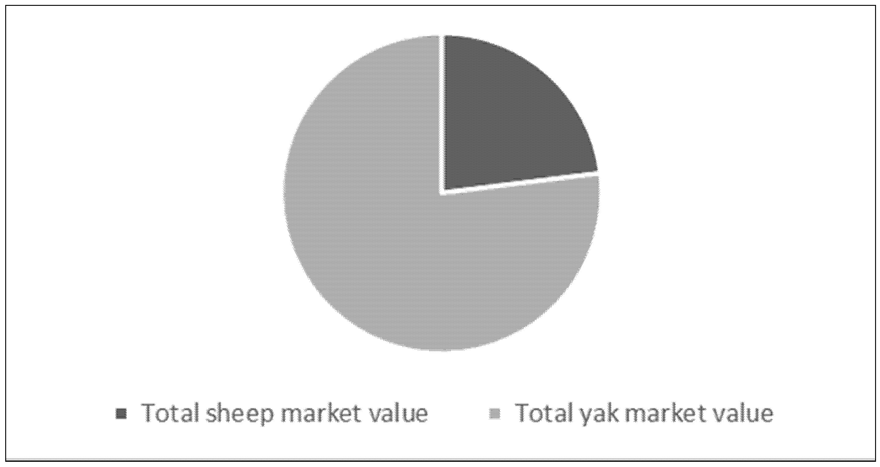
Based on market values of CNY 1200 for sheep and CNY 5000 for yaks, a total livestock value (sheep plus yaks) of CNY 2.01 billion in 2015, or approximately CNY 330,000 (approximately USD 47,000 (Calculation is based on 1 USD = 7 CNY)) per herder family, with yaks comprising 77% of this livestock value, can be estimated (Figure 11).

3.1.5. Animal Pests

The major small mammal pest species prevalent in Henan County is the plateau pika (Ochotona curzoniae) [17]. The researchers also observed a significant presence of Tibetan dwarf hamsters (Cricetulus kamensis) and marmots (Marmota himalayana). These small mammal pests, along with caterpillars (not the caterpillar fungus used in traditional Chinese medicine), consume considerable amounts of pasture. Local animal scientists advise that these mammal pests often prefer exposed and less shady pastures, and if the pastures are short and ground is bare, then these pests tend to “move in”. This preference raises a question as to whether increased pest populations on bare land might be an indicator and consequence as well as a fundamental cause of pasture degradation.
Control of these pests is challenging. Although the County Government, via its grassland station, sends out technicians every year to disseminate poisons for both small mammal pests and caterpillars, more than half of the farmers interviewed indicated that the supplied quantities are insufficient and that they purchase additional quantities. Other farmers said that trying to control the pests on their own land was pointless, because the pests do not respect boundaries, and control was ineffective unless all farmers act together.

3.1.6. Grassland Sustainability

Farmers recognised that the grasslands had become less productive. Older retired farmers spoke about the grass being knee-high in their younger years, but this had not been seen in recent years, with pastures no more than ankle-high. Indeed, most farmers interviewed expressed their concerns on the long-term sustainability of the grasslands to support their family livelihood. Small mammal pests and caterpillar outbreaks are among the most worrying reasons for their concerns. However, very few farmers acknowledged that excessive livestock numbers might be a key factor. Conversely, conversations with farmers indicated motivation to increase herd size as a source and indication of wealth.
It was evident that pastures were practically devoid of edible legumes, with the few surviving legumes containing toxic compounds and hence avoided by livestock. The consequent hypothesis, which would require further data collection to prove, is that edible legume species, which animals seek out because of their high plant protein content, have not survived the increased animal pressure. This has major implications both for animal productivity and also for grassland sustainability, with legumes being fundamental to the absorption of atmospheric nitrogen and the associated nitrogen cycle through plants and animals.

3.2. Changing Livelihoods

The changes to the landscape over these decades brought about substantial changes in the livelihoods of the local communities in Henan County. There are more infrastructures established both on farms and also in more densely populated towns. Modern transport and communications also enabled a greater exchange in information and goods between the county and the lowlands, bringing changes to the livelihoods in this community.

3.2.1. On-Farm Infrastructure and Assets

On-farm infrastructure has improved markedly over recent decades. Most farmers have a permanent house on their winter pastures, but still prefer to live for much of the year in a tent on their summer pastures. These are typically only a few kilometres away, but can be much more distant. Most winter houses have electricity connected to fixed lighting systems. Cooking and heating are undertaken with dung-fired micro furnaces, often located in the centre of a winter house, and with similar structures used in the summer tents. Solar panels are sometimes seen beside summer tents, linked to an adaptor, and often connected into portable televisions.
Horses are still used on farms, but motorbikes are the most common means of travel by farmers on farm, and to the county towns, which can be up to 50 km away. Some farmers also have utility vehicles.
There was also evidence, within the county, of tractors and seed drills, operated on farms by government-funded grassland station staff, to help with planting grass species in severely degraded areas.
County statistics show the fenced area within the county increased to 640,000 hectares (approximately 95% of the county) by 2004, but with no indication of linear length of fencing completed. No fencing data have been recorded within Henan County statistics since 2004. Much of the fencing is now derelict.

3.2.2. The Towns

The county encompasses six administrative sub-regions, each with its own town or township. The sub-regions range between 58,000 hectares and 180,000 hectares. The overarching county administration centre is Youganning Town, which is the largest settlement in Henan.
Youganning Town is vibrant with activity. The main street has many small shops, restaurants and other service facilities. Each shop has a name banner on the shop front, written in four languages—Chinese, Tibetan, Mongolian, and English. Within the town there is also a hospital, banks, credit unions, hotels, livestock, and produce markets, as well as temples, government buildings, a courthouse, and schooling to Year 9. There is solar-powered street lighting on most of the streets. The county centre also has several hotels and numerous restaurants and small eateries, many of which are operated by people who came from other provinces to take advantage of a developing tourism industry in the county.
A prominent building located on the main street is a four-story museum, dedicated to the Mongolian history of Henan County. Inside there is a 60-metre long, 1.5-metre high hand-drawn scroll by local artists of all the ordained princes, starting from first Prince of the First Order ordained by the Qing Emperor in 1723 [25].
These modern facilities reflect the investment that has been directed into Henan. Recent data indicate ongoing substantial fixed capital investment within Henan County, with a fixed capital investment in 2017 of CNY 1.887 billion (approximately USD 270 million), of which 84% came from State Government funds [48]. This total investment equates to a remarkable CNY 49,000 (approximately USD 7000) per person in the county, reflecting the perceived importance of Plateau development at the State Government level.

3.2.3. Transport and Communications

There is a two-lane highway linking Henan to the provincial capital, Xining. Prior to the present research, when the researchers first visited Henan in 2012, the journey from Xining took over six hours; by 2017 this had reduced to approximately 3.5 h. There are no airports in Henan. The main public transport is by bus, with services offered to all parts of Qinghai province and with connections further afield. There are public phone booths dotted around the streets. Most of the farmers interviewed had mobile phones.

3.2.4. Diet

The traditional diet in pastoral Henan was the pastoral products of meat and milk, supplemented by modest quantities of tsampa (roasted barley flour mixed with yak butter and cheese). The traditional diet contained minimal, if any, vegetables. Farmers interviewed noted that there was no word in the traditional Tibetan language for vegetables, and farmers in Henan use the Mandarin word “cai” (菜) for vegetables such as cabbages that they now consume. These vegetables are brought up from the lowlands and sold in the Plateau towns.
Another important food added to their diet is wheat flour purchased from the county centre, used to make noodles and bread (baked or fried). This has replaced a large proportion of the traditional barley–flour consumption. Non-staple short shelf-life fruit such as pineapples and kiwifruit are sold in ambient temperature county shops. Butchers in the Henan County centre sell slaughtered yaks and sheep that have been finished on grain in the lowlands. Although some people living in the towns buy these meats, including lowland migrants, farmers themselves mostly eat animals that are raised on their own farms and which they themselves slaughter. They consider the meats sold in town to have an unpleasant taste deriving from the lowland animal-feed in contrast to animals raised on natural pastures.

3.2.5. Market Demand for Henan’s Pastoral Products

There is a demand across China for pastoral-sourced products, which are widely perceived to be less contaminated than lowland products. Henan County is one such source for these products, which can be sold at premium prices. For example, packaged yak biltong is widely displayed in Xining, the capital city of Qinghai Province, where many Chinese come as visitors particularly during the hot lowland summers. Yak milk products from the Plateau are also sold at high prices, sometimes more expensive than imported milk products, in high-end supermarkets as far away as Beijing, which is about 1700 km by road from the eastern boundary of the Plateau.
Owing to the dominant Tibetan–Buddhist beliefs of the farmers, they themselves do not slaughter animals except for home use. Consequently, it is typically Muslim people who come up from the lowlands specifically to buy the animals, some of which are slaughtered locally by Muslin slaughtermen, and some are transported to lower altitudes for either direct slaughter or for further finishing. Retail butcher shops in the Henan County centre are also mostly run by Muslims who have migrated from the lowlands. Farmers sell their animals “on the hoof” without any weighing, and farmers themselves were typically unable to estimate live weights of their livestock when queried by the researchers.
An unexpected insight from the investigations was the importance of dung as a pastoral product. As a traditional practice on the Plateau, dung was the dominant and typically only fuel available for cooking and warmth within nomadic lifestyles, and this research confirmed that farmers still use dung as their main source of energy for cooking and warmth. However, the present study also showed that dung is a major commercial product, sold both on and off the Plateau. In Plateau towns it is used both for heating and cooking, and it is also taken to lower altitudes where it is valued as an organic fertiliser. A farmer owning about 200 sheep and 80 yaks reported that every year he could sell up to 200 bags of dung, which weigh about 25 kg each. Other farmers told the researchers that they deliver dung into the town for their parents, who have retired away from the farm and now live in the town in homes that have no heating. These parents of farmers also provide care for their school-age grandchildren who study in the town. It was apparent that the ash, which will be high in mineral nutrients, is not returned to the pastoral areas.
Farmers have also found other ways to diversify their income streams. During specific times of the year, normally around May, there are many street stalls put out by local people who sell caterpillar fungus (Ophiocordyceps sinensis), which is different from the pest caterpillar. This is dug out from the ground. This caterpillar fungus is known for its medicinal use in traditional Chinese medicine. Extracts are made into capsules or tablets, which can be seen in shops in Xining.
Most of the rain falls in summer, when farmers collect wild mushrooms that they sell by the side of the road at prices as high as 80 RMB per 500 g (approximately USD 25 per kg). These mushrooms from the Plateau are also sold in Xining markets and restaurants.

3.2.6. Life on Farm

Although elements of traditional livelihoods are still in existence, it is evident that life on the farm has changed greatly from the traditional pastoral lifestyles described by Miller [20]. Many of the changes relate to government-fostered sedentarisation, together with much stronger connectivity both between farmers and Plateau towns, and also between the Plateau and the rest of China.
The traditional delineations of men’s and women’s work remain evident. All milking of yaks and most collection of dung is undertaken by the women, who also have responsibility for cooking. Children who return to the farms during school holidays usually help with dung collection. Men’s responsibilities relate to herding and shepherding, together with trading, and any on-farm slaughter of animals. Further details of the farming systems are described in Lucock and Woodford [17].
This pastoral lifestyle remains challenging, and farmers rely on government subsidies as a major source of income. Subsidies are paid into farmers’ bank accounts, which appear to have no other use. Interviewees consistently said they did not use their bank accounts for daily living. All trading was done in cash, with livestock being an important asset class both for storing and augmenting wealth.
All interviewed active farmers were judged to be less than 50 years of age. Many of them had parents who had retired to the towns. Typically, there was an integration of three generations, with school children being cared for in town during term-time by grandparents, and the active farming generation also having responsibilities towards their own parents, including provision of pastoral products such as food and fuel. A typical pastoral couple has two children.
Most of the farmers interviewed had minimal literacy, and no farmers kept any written records. Most farmers interviewed showed little understanding of the Chinese language (Mandarin). However, the children of these farming families are bilingual in Tibetan and Mandarin. The researchers were advised that most adult people with literacy and Chinese language skills have moved to the towns for urban jobs.
The researchers met with some of the retired farmers who were visiting the farms with their grandchildren during school holidays. They expressed diverse perspectives about township life, with some regretting the loss of their pastoral lifestyles but others acknowledging aspects of convenience associated with town-living. They also acknowledged the importance of providing care to school-age grandchildren who would otherwise need to live in special boarding facilities.
Life on a farm in Henan County is no longer isolated from the outside world. Modern communication facilities, including satellite dishes, mobile televisions, and mobile phones, together with improved roads, have led to much greater connectivity between Henan and the rest of China. This increased connectivity provides farmers in Henan with information as to how other people live, and hence provides a basis for comparative reflectivity. Despite most of our interviewees expressing a liking for life out on the grasslands, all of them aspired for their children to have secure jobs as government officials and thereby live in towns or cities.

4. Discussion—A Transdisciplinary Systems Perspective

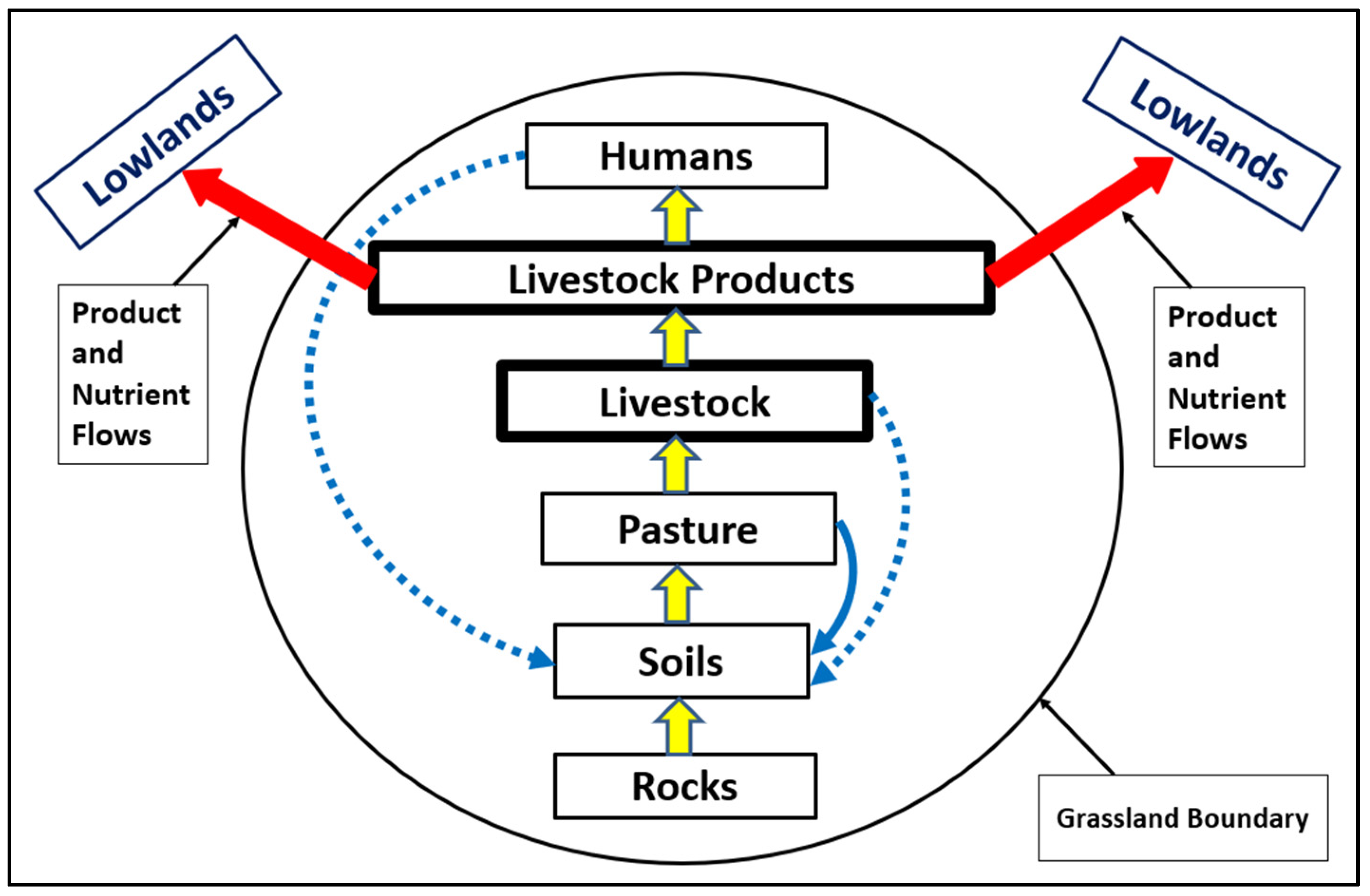
Up until the twentieth century, humans and the greater environment were apparently in a sustainable balance [18,20,23,28], evidenced by the fact that humans had lived on the Plateau for many thousands of years [63]. Given the geographical barriers and isolation of Plateau up until this point, the traditional livelihood systems can be described as low-density nomadic pastoralism, with nutrient recycling within an essentially closed system. This is depicted in Figure 12.
With very limited access in and out of the Plateau, most of the nutrients released by the natural weathering of rocks, and after passing from soils through plants, animals, and humans, remained on the Plateau. To reiterate, the Plateau was essentially a closed system.
None of the interviewees within this research had personal memories prior to the formation of the People’s Republic of China, but there was widespread belief among older people that major changes were occurring since the 1950s. This is consistent with stories from elsewhere across the Plateau. Essentially, the Plateau was opened up to outside influences. The two key influences driving change to the Plateau ecology at that time and thereafter were increasing human populations, presumably linked to improved human health, and a flow of pastoral products off the Plateau. Pastoral livestock numbers also increased. Many of these changes occurred after the series of land-policy implementations on the Plateau, but causal links between specific policies and specific livelihood changes are embedded within the system and not always individually explicit. What is apparent, however, is that an ecological imbalance has been created, with this becoming a casual factor contributing to large-scale degradation. The self-interest of individual communities, regardless of any explicit institutional factors, led to overstocking and declining soil fertility. This is depicted in Figure 13.
Compared to the traditional system, there is now less cycling of nutrients within the Plateau, and greatly enhanced outflows of nutrients to lowland cities from meat, milk and animal dung. A remarkable feature of the current system is that per-head productivity has greatly increased, presumably as a function of improved husbandry understandings and government-led targeted animal health programs. This improvement in per-head productivity compounds with increased livestock numbers in terms of product outflows as exports off the Plateau.
Although there is clear evidence that the consequent flow of nutrient-containing pastoral products off the Plateau has become substantial—this was evident from simple observation both on the Plateau itself and in towns below the Plateau—quantification of this would be a study in itself. Data collected from the present research, however, suggest that these flows are likely to be major contributors to the degradation of the Plateau ecological environment.
In contrast, there was no evidence of substantial inflow of biophysical nutrients to the Plateau. There is evidence of some inward flows of grain and hay from Henan County statistics up until 2005, but no subsequent data were found. In 2005 these inward flows approximated 2700 tonnes of feed. This quantity represents less than two days of feed per annum for the county livestock and would need to be greatly increased to change the overall nutrient-balance equation.
Observation of greatly enhanced plant growth in stock corrals compared to outside these corrals confirmed that soil fertility was limiting. With the Central Government’s policy that all of the Sanjiangyuan area is to be farmed organically, including an absence of non-organic fertilisers and sprays, additional constraints on pasture productivity are likely.
Upon a reflection of the present study, the challenges of a transdisciplinary approach in a world where scientific endeavour encourages specialisation and disciplinarity can be echoed [64]. The present study confirmed that livelihoods always take place within a broad but specific bio-socio-economic context. It is this overarching livelihood context where human behavioural integration occurs. It is this human behavioural integration that requires a transdisciplinary systems approach, with an emphasis on situational evidence of “what and why” within an open and exploratory analytical framework.

5. Conclusions

The overarching challenges for Henan County relate to the interactions between a population that has been increasing rapidly and is likely to further increase, albeit more slowly than in the past, together with non-sustainable farming systems dominated by outward flows of biophysical nutrients off the Plateau within animal products of meat, milk, and dung. Although there have been major infrastructure developments within the county, education and health facilities remain at lower levels than for communities who live below the Plateau. Apart from pastoralism and perhaps tourism, it is challenging to identify other industries that might prosper on the Plateau without ongoing subsidisation from outside the Plateau.
Fundamental to all of these issues is that Henan as a community is in the midst of a long-term transition from traditional nomadic pastoralism to modern lifestyles and increasing connectivity with people and ideas from beyond the Plateau. Linked to this is the importance of the Sanjiangyuan region as the watershed of China’s three most important rivers, and consequent major externalities associated with Henan County livelihoods that extend beyond both the County and the broader Qinghai–Tibet Plateau. These issues can only be addressed within a dynamic multi-layered transdisciplinary systems perspective that includes foci on both inward and outward nutrient and economic resource flows. Although the specifics of this paper relate to Henan County, and noting that policy implementation and hence system outcomes can differ between counties within the region, the broader issues are likely to be relevant to sustainable land use and livelihood policies across the broader Qinghai–Tibet Plateau and indeed other rangeland regions of the world.
The present research has been limited to existing and at times incomplete statistics combined with primary data collection that is exploratory and mostly qualitative in nature. The dynamic complexity revealed by the interdisciplinary systems perspective is novel and warrants further attention in future research seeking specific solutions for a sustainable future of the Qinghai–Tibet Plateau. These future necessary studies include quantitative disciplinary studies, but with recommendations also guided by the interdisciplinary systems perspective, to maintain the balance and checks of the complex world that we live in.

Author Contributions

Conceptualization, X.L. (Xiaomeng Lucock) and K.W.; methodology, X.L. (Xiaomeng Lucock) and K.W.; software, X.L. (Xiaomeng Lucock); validation, X.L. (Xiaomeng Lucock), K.W. and X.L. (Xilai Li); formal analysis, X.L. (Xiaomeng Lucock) and K.W.; investigation, X.L. (Xiaomeng Lucock), K.W. and X.L. (Xilai Li); resources, X.L. (Xiaomeng Lucock) and X.L. (Xilai Li); data curation, X.L. (Xiaomeng Lucock)and X.L. (Xilai Li); writing—original draft preparation, X.L. (Xiaomeng Lucock); writing—review and editing, X.L. (Xiaomeng Lucock)and K.W.; visualization, X.L. (Xiaomeng Lucock); supervision, X.L. (Xiaomeng Lucock); project administration, X.L. (Xiaomeng Lucock); funding acquisition, X.L. (Xiaomeng Lucock) and X.L. (Xilai Li). All authors have read and agreed to the published version of the manuscript.

Funding

This research was funded by the Qinghai Science and Technology Department, grant number 2020-ZJ-904, the New Zealand Ministry of Business, Innovation and Employment, grant number LINX1404, and the Chinese Ministry of Science and Technology, grant number 2015DFG31870. The APC was jointly funded by Lincoln University, New Zealand and Qinghai University, China.

Institutional Review Board Statement

The study was conducted in accordance with the guidelines of the Human Ethics Committee of Lincoln University, New Zealand.

Informed Consent Statement

Informed consent was obtained from all subjects involved in the study.

Data Availability Statement

The data presented in this study are available on request from the corresponding author. The data are not publicly available due to confidentiality.

Acknowledgments

Our work draws on information provided by citizens of Henan County, both pastoralists living on the grasslands and others who live and hold positions within the Henan County centre. We acknowledge their willing assistance, together with the assistance and insights of officials who facilitated our work. We also acknowledge many helpful discussions with colleagues from within our broader research program. We would also like to give our thanks to the anonymous referees, who kindly took their time and gave us very constructive feedback on our manuscript.

Conflicts of Interest

The authors declare no conflict of interest. The founding sponsors had no role in the design of the study; in the collection, analyses, or interpretation of data; in the writing of the manuscript; and in the decision to publish the results.

References

  1. Aznar-Sánchez, J.A.; Piquer-Rodríguez, M.; Velasco-Muñoz, J.F.; Manzano-Agugliaro, F. Worldwide research trends on sustainable land use in agriculture. Land Use Policy 2019, 87, 104069. [Google Scholar] [CrossRef]
  2. Zhang, X.; Liu, H.; Xing, Z. Challenges and Solutions for Sustainable Land Use in Ruoergai-the Highest Altitude Peatland in Qinghai-Tibetan Plateau, China. Energy Procedia 2011, 5, 1019–1025. [Google Scholar] [CrossRef] [Green Version]
  3. Cao, J.; Yeh, E.T.; Holden, N.M.; Yang, Y.; Du, G. The effects of enclosures and land-use contracts on rangeland degradation on the Qinghai–Tibetan plateau. J. Arid. Environ. 2013, 97, 3–8. [Google Scholar] [CrossRef]
  4. Qiu, J. Trouble in Tibet. Nature 2016, 529, 142–145. [Google Scholar] [CrossRef] [Green Version]
  5. Waldron, S.; Brown, C.; Longworth, J. Grassland degradation and livelihoods in China’s western pastoral region: A framework for understanding and refining China’s recent policy responses. China Agric. Econ. Rev. 2010, 2, 298–320. [Google Scholar] [CrossRef]
  6. Wang, J.; Wang, Y.; Li, S.; Qin, D. Climate adaptation, institutional change, and sustainable livelihoods of herder communities in northern Tibet. Ecol. Soc. 2016, 21, 5. [Google Scholar] [CrossRef] [Green Version]
  7. Yan, J.; Wu, Y.; Zhang, Y. Adaptation strategies to pasture degradation: Gap between government and local nomads in the eastern Tibetan Plateau. J. Geogr. Sci. 2011, 21, 1112. [Google Scholar] [CrossRef]
  8. Yeh, E.T. Green governmentality and pastoralism in western China: ‘Converting pastures to grasslands’. Nomadic Peoples 2005, 9, 9–30. [Google Scholar] [CrossRef]
  9. Brierley, G.; Li, X.; Chen, G. Landscape and Environment Science and Management in the Sanjiangyuan Region; Qinghai People’s Publishing House: Xining, China, 2010. [Google Scholar]
  10. Ptackova, J. Sedentarisation of Tibetan nomads in China: Implementation of the nomadic settlement project in the Tibetan Amdo area; Qinghai and Sichuan Provinces. Pastor. Res. Policy Pract. 2011, 1, 4. [Google Scholar] [CrossRef] [Green Version]
  11. Yeh, E.T. Tibetan Range Wars: Spatial Politics and Authority on the Grasslands of Amdo. Dev. Chang. 2003, 34, 499–523. [Google Scholar] [CrossRef]
  12. Gongbuzeren; Zhuang, M.; Li, W. Market-based grazing land transfers and customary institutions in the management of rangelands: Two case studies on the Qinghai-Tibetan Plateau. Land Use Policy 2016, 57, 287–295. [Google Scholar] [CrossRef]
  13. Huang, W.; Bruemmer, B.; Huntsinger, L. Technical efficiency and the impact of grassland use right leasing on livestock grazing on the Qinghai-Tibetan Plateau. Land Use Policy 2017, 64, 342–352. [Google Scholar] [CrossRef]
  14. Cao, J.; Li, G.; Adamowski, J.F.; Holden, N.M.; Deo, R.C.; Hu, Z.; Zhu, G.; Xu, X.; Feng, Q. Suitable exclosure duration for the restoration of degraded alpine grasslands on the Qinghai-Tibetan Plateau. Land Use Policy 2019, 86, 261–267. [Google Scholar] [CrossRef]
  15. Zhuang, M.; Gongbuzeren; Zhang, J.; Li, W. Community-based seasonal movement grazing maintains lower greenhouse gas emission intensity on Qinghai-Tibet Plateau of China. Land Use Policy 2019, 85, 155–160. [Google Scholar] [CrossRef]
  16. Wang, W.; Zhao, X.; Cao, J.; Li, H.; Zhang, Q. Barriers and requirements to climate change adaptation of mountainous rural communities in developing countries: The case of the eastern Qinghai-Tibetan Plateau of China. Land Use Policy 2020, 95, 104354. [Google Scholar] [CrossRef]
  17. Lucock, X.; Woodford, K. Pastoral farming on the Qinghai-Tibet Plateau. Int. J. Agric. Manag. 2018, 6, 141–145. [Google Scholar]
  18. Miller, D.J. Tough times for Tibetan nomads in western China: Snowstorms, settling down, fences and the demise of traditional nomadic pastoralism. Nomadic Peoples 2000, 4, 83–109. [Google Scholar] [CrossRef]
  19. Zhang, Y.; Li, B.; Zheng, D. Boundries and areas of Qinghai-Tibet Plateau. Geogr. Res. 2002, 21, 1–8. [Google Scholar]
  20. Miller, D.J. Nomads of the Tibetan Plateau rangelands in western China. Part Two. Pastoral production practices. Rangel. Arch. 1999, 21, 16–19. [Google Scholar]
  21. China Insitute of Water Resources and Hydropower Research. Introduction on Sanjiangyuan National Nature Reserve. Available online: http://www.iwhr.com/zgskyww/ztbd/qhdy/bjcl/webinfo/2012/08/1342498799296495.htm (accessed on 24 January 2022).
  22. Kmusser. Map of Ü-Tsang Amdo and Kham. 2011. Available online: https://commons.wikimedia.org/wiki/File:Tibet_provinces.png (accessed on 24 January 2022).
  23. Manderscheid, A. Decline and re-emergence of nomadism: Tibetan pastoralists revive a nomadic way of life and production. GeoJournal 2001, 53, 173–182. [Google Scholar] [CrossRef]
  24. Croquant. Location of Henan County (pink) and Huangnan Prefecture (yellow) within Qinghai Province of China. 2007. Available online: https://en.wikipedia.org/wiki/Henan_Mongol_Autonomous_County#/media/File:Location_of_Henan_within_Qinghai_(China).png (accessed on 24 January 2022).
  25. Cairang, Z. Mongolian Records on South of Yellow River; Gansu Ethnic Publishing House: Gansu, China, 2010. [Google Scholar]
  26. Dhondup, Y. Writers at the Crossroads: The Mongolian-Tibetan Authors Tsering Dondup and Jangbu. Inner Asia 2002, 4, 225. [Google Scholar] [CrossRef]
  27. Wallenböck, U. Marginalisation at China’s Multi-Ethnic Frontier: The Mongols of Henan Mongolian Autonomous County in Qinghai Province. J. Curr. Chin. Aff. 2016, 45, 149–182. [Google Scholar] [CrossRef] [Green Version]
  28. Goldstein, M.C.; Beall, C.M.; Cincotto, R.P. Traditional nomadic pastoralism and ecological conservation on Tibet’s Northern Plateau. Natl. Geogr. Res. 1990, 6, 139–156. [Google Scholar]
  29. Miller, D.J.; Schaller, G.B. Rangelands of the Chang Tang Wildlife Reserve in Tibet. Rangelands 1996, 18, 91. [Google Scholar]
  30. Shang, Z.; Gibb, M.; Long, R. Effect of snow disasters on livestock farming in some rangeland regions of China and mitigation strategies—A review. Rangel. J. 2012, 34, 89–101. [Google Scholar] [CrossRef]
  31. Goldstein, M.C.; Childs, G.; Wangdui, P. “Going for income” in village Tibet. Asian Surv. 2008, 48, 514–534. [Google Scholar] [CrossRef] [Green Version]
  32. Tashi, G.; Foggin, M. Resettlement as development and progress? Eight years on: Review of emerging social and development impacts of an ‘ecological resettlement’ project in Tibet Autonomous Region, China. Nomadic Peoples 2012, 16, 134–151. [Google Scholar] [CrossRef]
  33. Huber, T. Amdo Tibetans in Transition: Society and Culture in the Post-Mao Era: PIATS 2000: Tibetan Studies: Proceedings of the Ninth Seminar of the International Association for Tibetan Studies, Leiden 2000; Brill: Leiden, The Netherlands, 2002; Volume 5. [Google Scholar]
  34. Harris, R.B. Rangeland degradation on the Qinghai-Tibetan plateau: A review of the evidence of its magnitude and causes. J. Arid. Environ. 2010, 74, 1–12. [Google Scholar] [CrossRef]
  35. Chen, G.; Li, X.; Gao, J.; Brierley, G. Wetland Types and Evolution and Rehabilitation in the Sanjiangyuan Region; Qinghai People’s Publishing House: Xining, China, 2010. [Google Scholar]
  36. Dell’Angelo, J. The sedentarization of Tibetan nomads: Conservation or coercion? In Ecological Economics from the Ground Up; Healy, H., Martínez-Alier, J., Temper, L., Walter, M., Gerber, J.-F., Eds.; Routledge: London, UK, 2013; pp. 309–333. [Google Scholar]
  37. Su, D.X.; Meng, Y.D.; Wu, B.G. Agricultural Industry Standards of P.R.China—Calculation of Proper Carrying Capacity of Rangelands (NY/T 635–2002); Standards Press of China: Beijing, China, 2003. [Google Scholar]
  38. Eisenhardt, K.M. Building Theories from Case Study Research. Acad. Manag. Rev. 1989, 14, 532–550. [Google Scholar] [CrossRef]
  39. Eisenhardt, K.M. Better Stories and Better Constructs: The Case for Rigor and Comparative Logic. Acad. Manag. Rev. 1991, 16, 620–627. [Google Scholar] [CrossRef]
  40. Eisenhardt, K.M.; Graebner, M.E. Theory building from cases: Opportunities and challenges. Acad. Manag. J. 2007, 50, 25–32. [Google Scholar] [CrossRef] [Green Version]
  41. Eisenhardt, K.M.; Graebner, M.E.; Sonenshein, S. Grand challenges and inductive methods: Rigor without rigor mortis. Acad. Manag. J. 2016, 59, 1113–1123. [Google Scholar] [CrossRef]
  42. Bruegger, R.A.; Jigjsuren, O.; Fernández-Giménez, M.E. Herder Observations of Rangeland Change in Mongolia: Indicators, Causes, and Application to Community-Based Management. Rangel. Ecol. Manag. 2014, 67, 119–131. [Google Scholar] [CrossRef]
  43. Sherren, K.; Darnhofer, I. Precondition for Integration: In Support of Stand-alone Social Science in Rangeland and Silvopastoral Research. Rangel. Ecol. Manag. 2018, 71, 545–548. [Google Scholar] [CrossRef]
  44. Wilmer, H.; Fernández-Giménez, M.E. Voices of Change: Narratives from Ranching Women of the Southwestern United States. Rangel. Ecol. Manag. 2016, 69, 150–158. [Google Scholar] [CrossRef]
  45. Henan Mongolian Autonomous County Bureau of Statistics. Henan County Yearbook 2006; Henan Mongolian Autonomous County Bureau of Statistics: Henan Mongolian Autonomous County, China, 2007.
  46. Henan Mongolian Autonomous County Bureau of Statistics. Henan County Yearbook 2014; Henan Mongolian Autonomous County Bureau of Statistics: Henan Mongolian Autonomous County, China, 2015.
  47. Henan Mongolian Autonomous County Bureau of Statistics. Henan County Yearbook 2015; Henan Mongolian Autonomous County Bureau of Statistics: Henan Mongolian Autonomous County, China, 2016.
  48. Henan Mongolian Autonomous County Bureau of Statistics. Henan County Yearbook 2018; Henan Mongolian Autonomous County Bureau of Statistics: Henan Mongolian Autonomous County, China, 2019.
  49. Henan Mongolian Autonomous County People’s Government. South to the Heaven River; Qinghai People’s Publishing House: Qinghai, China, 2009.
  50. Henan Mongolian Autonomous County Yearbook Editorial Committee. Henan County Yearbooks 1991–2000; Gansu People’s Publishing House Lanzhou: Gansu, China, 2004. [Google Scholar]
  51. Henan Mongonlian Autonomous County Agriculture and Animal Husbandry Planning Committee. Henan Mongonlian Autonomous County Agriculture and Animal Husbandry Planning; Henan Mongonlian Autonomous County Agriculture and Animal Husbandry Planning Committee: Henan Mongol Autonomous County, China, 1985. [Google Scholar]
  52. National Bureau of Statistics of China. 15–3 Length of Transport Routes at Year-end by Region (End of 2000). In China Statistical Yearbook 2001; National Bureau of Statistics of China: Beijing, China, 2001. [Google Scholar]
  53. National Bureau of Statistics of China. 15–29 Number of Private-owned Vehicles. In China Statistical Yearbook 2001; National Bureau of Statistics of China: Beijing, China, 2001. [Google Scholar]
  54. National Bureau of Statistics of China. 4–3 Total Population and Sex Ratio by Region. In China Statistical Yearbook 2001; National Bureau of Statistics of China: Beijing, China, 2001. [Google Scholar]
  55. National Bureau of Statistics of China. 16–42 Main Communication Capacity of Telecommunications (Year-end). In China Statistical Yearbook 2005; National Bureau of Statistics of China: Beijing, China, 2005. [Google Scholar]
  56. National Bureau of Statistics of China. 2–6 Population at Year-end by Region. In China Statistical Yearbook 2018; National Bureau of Statistics of China: Beijing, China, 2019. [Google Scholar]
  57. National Bureau of Statistics of China. 16–4 Length of Transport Routes at Year-end by Region (2017). In China Statistical Yearbook 2018; National Bureau of Statistics of China: Beijing, China, 2019. [Google Scholar]
  58. National Bureau of Statistics of China. 16–34 Main Communication Capacity of Telecommunications at Year-end. In China Statistical Yearbook 2018; National Bureau of Statistics of China: Beijing, China, 2019. [Google Scholar]
  59. National Bureau of Statistics of China. 16–21 Possession of Private Vehicles. In China Statistical Yearbook 2018; National Bureau of Statistics of China: Beijing, China, 2019. [Google Scholar]
  60. The State Council Information Office of the People’s Republic of China. Ethnic and population profile of Tibet Autonomous Region. Available online: http://www.scio.gov.cn/ztk/dtzt/04/08/5/Document/392015/392015.htm (accessed on 9 December 2021).
  61. FAOSTAT. Annual Population, China; FAO: Rome, Italy, 2018. [Google Scholar]
  62. Hesketh, T.; Zhu, W.X. The one child family policy: The good, the bad, and the ugly. BMJ 1997, 314, 1685–1687. [Google Scholar] [CrossRef]
  63. Aldenderfer, M. Peopling the Tibetan Plateau: Insights from Archaeology. High Alt. Med. Biol. 2011, 12, 141–147. [Google Scholar] [CrossRef]
  64. Steelman, T.; Nichols, E.G.; James, A.; Bradford, L.; Ebersöhn, L.; Scherman, V.; Omidire, F.; Bunn, D.N.; Twine, W.; McHale, M.R. Practicing the science of sustainability: The challenges of transdisciplinarity in a developing world context. Sustain. Sci. 2015, 10, 581–599. [Google Scholar] [CrossRef]
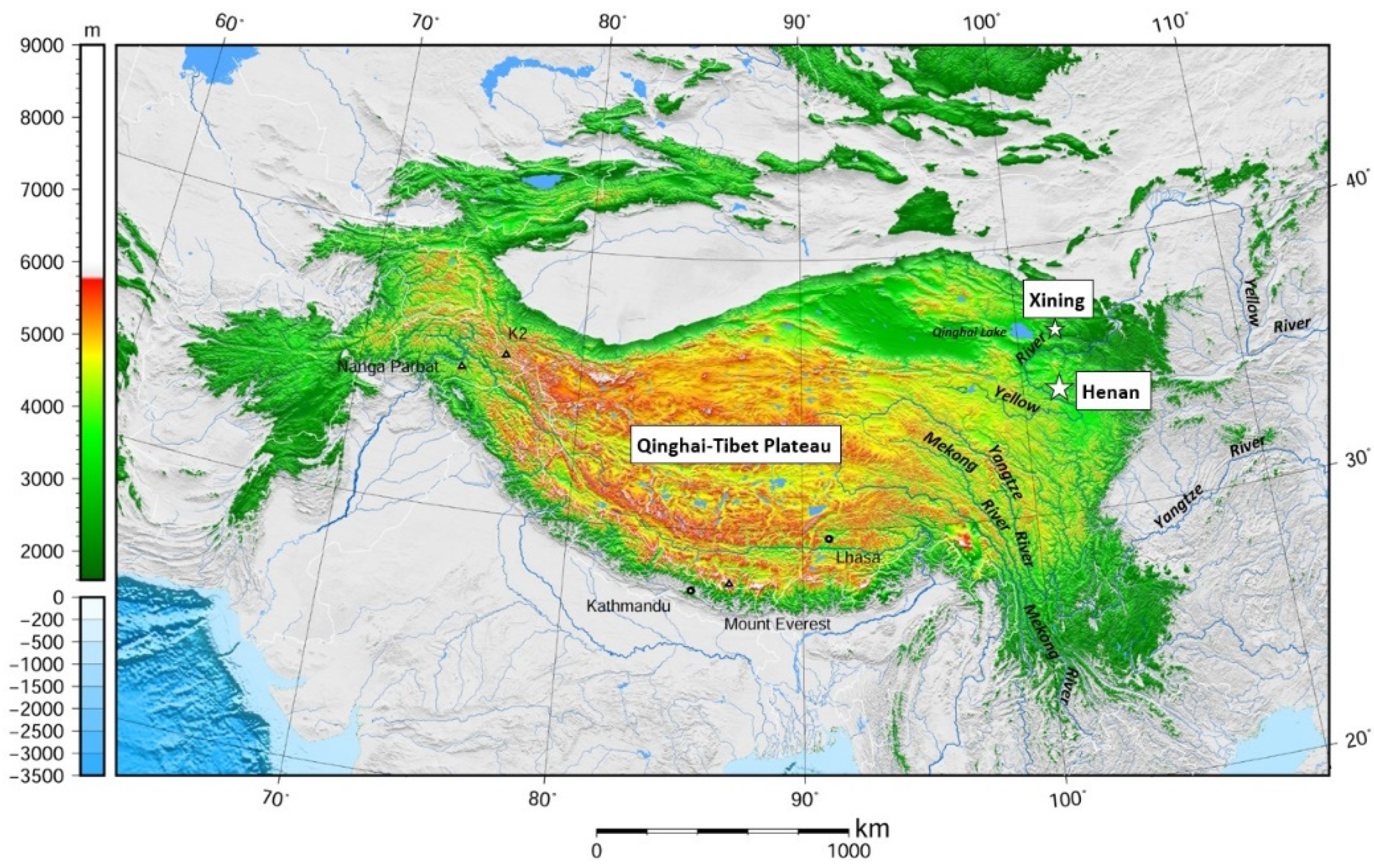
Figure 1. Map of Qinghai–Tibet Plateau (adapted with permission from Ref. [17]. 2018, Int. J. Agric. Manag.).
Sustainability 14 07785 g001
Figure 2. Map of Ü-Tsang Amdo and Kham [22] (creative common).
Sustainability 14 07785 g002
Figure 3. Location of Henan County (pink) and Huangnan Prefecture (yellow & pink) within Qinghai Province of Mainland China (the light blue area is Qinghai Lake) [24] (creative common).
Sustainability 14 07785 g003
Figure 4. Total Rainfall and Evaporation in Henan County 1985 to 2015.
Sustainability 14 07785 g004
Figure 5. Average Temperature in Henan County 1985 to 2015.
Sustainability 14 07785 g005
Figure 6. Average Monthly Rainfall Distribution in Henan County 1985 to 2015.
Sustainability 14 07785 g006
Figure 7. Total Frost Free Days in Henan County 1985 to 2015.
Sustainability 14 07785 g007
Figure 8. Total Henan County Population 1960 to 2015.
Sustainability 14 07785 g008
Figure 9. Total Number of Yaks, Sheep and Stock Unit Equivalents (SUE) in Henan County at Year End, 1960 to 2015.
Sustainability 14 07785 g009
Figure 10. Henan County Livestock Product Output in tonnes 1985 to 2015.
Sustainability 14 07785 g010
Figure 11. Henan County Total Sheep and Yak Livestock Market Value Comparison in 2015.
Sustainability 14 07785 g011
Figure 12. Traditional Sustainable Grassland Systems with Recycling of Nutrients depicted by Blue Lines.
Sustainability 14 07785 g012
Figure 13. Modern Non-sustainable Grassland Systems with Nutrients Outflows.
Sustainability 14 07785 g013
Publisher’s Note: MDPI stays neutral with regard to jurisdictional claims in published maps and institutional affiliations.