Article

Analysis of the Spatial Differentiation and Development Optimization of Towns’ Livable Quality in Aksu, China

1
College of Geography and Remote Sensing Sciences, Xinjiang University, Urumqi 830017, China
2
Xinjiang Key Laboratory of Oasis Ecology, Xinjiang University, Urumqi 830017, China
*
Author to whom correspondence should be addressed.
Sustainability 2022, 14(13), 7728; https://doi.org/10.3390/su14137728
Submission received: 29 March 2022 / Revised: 21 June 2022 / Accepted: 22 June 2022 / Published: 24 June 2022
(This article belongs to the Special Issue Urban Economics, City Development and Future Social Challenges)

Abstract

:
With the proposal of the United Nations Sustainable Development Goals (SDGs), how to effectively improve the quality of human settlements has become a hot spot. Governments and scholars around the world pay attention to reasonable improvement of livability, which is conducive to improving the happiness level of residents and is closely related to human well-being. Due to the lack of rural statistical data in Xinjiang, this study established a new comprehensive evaluation system, which selected 21 indicators from the natural and humanistic aspects. The results show that the overall ecological security of Aksu prefecture is good, and Kuche city has the best humanistic livability performance. In terms of the livable quality of towns, Kuche Urban Area performs best. The towns with excellent and good livable quality are concentrated, but their spatial connections are weak. Based on the analysis and survey results, we put forward zoning optimization suggestions for the livable quality in Aksu prefecture. The results of this study would provide directional guidance for the improvement of livable quality in Aksu prefecture. At the same time, we expect that it can provide a methodological supplement for the relevant evaluation in other similar regions.

1. Introduction

The concept of human settlement was first proposed by Doxiadis in the 1950s and founded the science of human settlements [1,2]. Doxiadis believes that human settlement should be a whole in space, and Geddes also believes that urban planning cannot ignore the development of rural areas [3]. The United Nations “Vancouver Declaration” first put forward the concept of “human settlements”, including social, material, spiritual, cultural elements, etc., covering cities and towns [4]. In the 1990s, Chinese scholar Liangyong Wu proposed the science of human settlements, covering social, economic, ecological, cultural, technological, and other aspects, and formed a scientific system of human settlements based on Chinese experience [5]. The 16th Annual Session of Global Forum on Human Settlement pointed out that building green, healthy, and resilient cities is conducive to promoting global economic development, progress, and prosperity [6]. The construction of sustainable cities is of great significance to improve the service level of human settlements and better benefit mankind. With the advancement of urbanization and industrialization, the rapid development of many developing countries has led to a series of urban and rural problems, such as air pollution, traffic congestion, insufficient public facilities, and uneven urban–rural development [7]. The emergence of these problems will continue to affect the happiness index of residents in urban and rural areas, and even become an incentive for crime. Research has shown that livable quality is highly correlated with personal well-being [8]. Livable quality has gradually become a topic of great concern to governments, scholars, and residents around the world.
In urban development in developed areas, the rapid expansion of cities and the increase of residents’ demand for consumption and services have brought pressure and challenges to the sustainable development of society and the environment [9]. In developing areas, the living standards of residents often do no keep up with the pace of economic development. The rapid development has neglected the coordination between economic growth and livability and deviated from the people-centered development themes [10,11]. For human beings, the environment—whether it is the economic, social, or ecological environment—is an essential factor that intuitively affects the livable quality [12]. Adhering to the people-centered development philosophy, satisfying the people’s yearning for a better life, and realizing the all-round development of people are the fundamental goals of upholding and improving the socialist system with Chinese characteristics and advancing the modernization of the country’s governance system and governance capacity [13]. The Fifth Plenary Session of the 19th Central Committee of the Communist Party of China mentioned the development goals that the urban and rural livable environment could significantly improve, and the people’s livelihood could reach a new level. The livable quality is an indicator to measure the living standards of people in a particular region, and it can also reflect the ability of a region to transform from economic level to living standard. Whether in urban or rural areas, studying the current status and optimization strategies of livable quality is of great significance to its all-round high-quality development and the improvement of people’s living security ability [14].
Scholars around the world have widely discussed the research on livable quality. Disciplines include economics and management, architecture and planning, geography, etc. [15,16,17]. The research areas concentrate mostly in the regions with relatively developed economies and society, and the research scales are almost above the county level [18,19,20,21]. The research methods are mainly divided into three categories. The first category is to build an evaluation system based on economic, social, and other statistical data to evaluate the livable quality of the study area [22,23]. The second category is to build a comprehensive index of livable quality and then make a weighted analysis of regional livable quality with the help of rasterized natural and humanistic data [24,25]. The last category is to carry out statistics and analysis on the satisfaction with the livable quality in questionnaires [26,27]. Previous studies on the livable quality are only based on either statistical survey data or raster image data. However, this study combines these two kinds of data, and thus avoids the trade-off problems caused by using only one of them. There will be no defects in the research due to incomplete selection of indicators or excessive subjectivity. Therefore, our research adopts the method of equal weight superposition of raster data and statistical data to study the livable quality.
As an organic part of geography, human settlements science also follows the laws and theories of geography and carries out human settlements research from a geographical perspective, which has gradually become an important academic trend in the field of human settlements science. The livable quality is affected by many factors, which can be roughly divided into ecological environment factors and livable conditions factors [16]. The minimum cumulative resistance model can represent the spatial distribution of ecological levels [28,29]. This paper uses raster data to evaluate the safety level of the ecological environment in Aksu prefecture through the minimum cumulative resistance model, to characterize the natural livable quality. In addition, we evaluated the humanistic livable quality of society, economy, culture, education, etc. using the TOPSIS model. This study aims to: (1) quantitatively measure the overall ecological environment quality and humanistic livable level in Aksu area; (2) According to the overall measurement results, assign natural livability and humanistic livability according to townships, and obtain the livable quality and their spatial connection levels of townships; (3) Combined with the analysis results, this paper puts forward some suggestions on the optimal development of townships’ livable quality in Aksu prefecture. The research on livable quality is conducive to providing data and theoretical support for the livable construction of cities and towns, promoting the sustainable development of urban and rural society, and is of great significance to improve residents’ life satisfaction and happiness.

2. Materials and Methods

2.1. Study Area

Aksu prefecture (including Alaer city, collectively referred to as Aksu prefecture in this paper) is located in northwest China and the middle of Xinjiang Uygur Autonomous Region, with an attitude of 945~7435 m. It belongs to a typical temperate continental climate, with dryness, little rainfall, large evaporation, and abundant natural resources. In 2020, the regional GDP was CNY 131.505 billion, and the total population was 3.124 million, with industry and agriculture as the leading industries. The economic development of Aksu prefecture is at a medium level. Still, the level of basic public services such as education, medical care, and transportation is poor, and the internal distribution is uneven. The geographical position of Aksu prefecture is shown in Figure 1.

2.2. Data Sources

The elevation data and slope data of the Aksu prefecture with a resolution of 90 m are derived from the Geospatial Data Cloud (www.gscloud.cn) [30]. The normalized difference vegetation index (NDVI), soil erosion, main road, administrative division, and land use data are from the Data Center for Resources and Environmental Sciences of the Chinese Academy of Sciences (www.resdc.cn) [31]. The data of ecological reserves come from Aksu prefecture natural resources bureau. Other relevant statistical data come from “Aksu Prefecture Statistical Yearbook (2019)”, “Xinjiang Production and Construction Corps Statistical Yearbook (2019)”, “Alar City Statistical Yearbook (2019)”, and “China County Statistical Yearbook (2019)”.

2.3. Index System Construction and Methodology

2.3.1. The Construction of Index System

(1)
Index system of natural livable quality
Referring to previous studies [32,33], the ecological reserve in Aksu prefecture was selected as the ecological source. The elevation, slope, NDVI, soil erosion degree, annual precipitation, days of floating dust, number of earthquakes (≥3.0), and distance from the main road were selected as resistance factors in combination with local conditions. Each resistance factor is divided into five grades, and the resistance coefficient is assigned to each grade. The classification of these factors is based on previous studies on ecological security and MCR model [29,34], combined with the classification results of the natural discontinuity method in ArcGIS 10.2. (Environmental Systems Research Institute, Inc., Redlands, CA, USA) The weight of each factor is determined by the entropy method. The evaluation index system of the natural livable quality constructed in this paper is shown in Table 1.
(2)
Index system of humanistic livable quality
This paper selects 11 indicators from five aspects of economic development, culture and education, transportation, public infrastructure, health, and medical security to construct the index system to evaluate the overall humanistic livable quality of the counties and cities in Aksu prefecture. The evaluation index system of the humanistic livable quality constructed in this paper is shown in Table 2.

2.3.2. Determination of Weight

There are many methods to determine the weight, including principal component analysis, entropy method, analytic hierarchy process, and so on [35,36,37]. After analyzing the degree of correlation between previous studies and this study, and comparing the above three methods, it was found that the entropy method is the most suitable method for the data of this study.
To standardize the indicators and eliminate the influence of dimensions, this paper selects the range standardization method [38,39]. The specific methods are as follows:
Positive indicators:
x i j = x i j m i n ( x 1 j ,   x 2 j ,   ,   x n j ) m a x ( x 1 j ,   x 2 j ,   ,   x n j ) m i n ( x 1 j ,   x 2 j ,   ,   x n j )
Negative indicators:
x i j = m a x ( x 1 j ,   x 2 j ,   ,   x n j ) x i j m a x ( x 1 j ,   x 2 j ,   ,   x n j ) m i n ( x 1 j ,   x 2 j ,   ,   x n j )
where x i j is the jth index value of the ith area (i = 1, 2, …, n; j = 1, 2, …, m).
The index contribution of the jth index value to the ith area:
p i j = x i j i n x i j
Entropy calculation:
e j = 1 ln n i = 1 n p i j ln ( p i j ) , e j 0
Difference coefficient calculation:
g j = 1 e j
Weight calculation:
w j = g j j m g j , j = 1 , 2 , , m

2.3.3. Minimum Cumulative Resistance Model (MCR)

The minimum cumulative resistance model is the model that calculates the cost of the movement from the “source” to the destination [40,41], where the ecological cost distance is used to measure the natural livable quality. The formula is as follows:
R M C = f m i n j = n i = m ( D i j R i )
where RMC is the minimum cumulative resistance value from source j to a point in space; Dij refers to the spatial distance from source j to landscape unit i. Ri is the resistance coefficient of the landscape unit i to the particle movement.

2.3.4. TOPSIS Model

The TOPSIS model is used to calculate the proximity of each evaluation unit to the ideal point, that is, the relative proximity. The larger the relative proximity, the closer the evaluation unit is to the ideal level [42,43]. The formula is as follows:
d i + = j = 1 n ( R i j R i + ) 2 ,   d i = j = 1 n ( R i j R i ) 2
C j = d i d i + + d i
where d i + , d i are the distances between each evaluation unit and the positive or negative ideal solutions and Cj is the relative proximity. The relative proximity Cj is in the range of [0, 1]; the larger the Cj, the closer the jth evaluation unit is to the ideal level, and the higher the suitability of the evaluation unit.

2.3.5. Gravity Model

The gravity model is used to measure the impact of cities on the livable quality of towns, and the visual expression of the spatial radiation of livable quality can be obtained [44,45]. The formula is as follows:
I i j = G M i M j r b
where the empirical coefficient G takes 1, Mi and Mj as the ith and jth gravitational units. The friction coefficient b is taken as 2, which is more in line with the actual situation and consistent with Newton’s universal gravitation model.

3. Results Analysis

3.1. Overall Analysis of Prefecture

3.1.1. Natural Livable Quality

We used the cost distance tool of ArcGIS 10.2 to obtain four types of zones of natural livable quality in Aksu prefecture. From the overall level, the natural livable quality of Aksu prefecture is good. There are only small areas of poor level zones in the west and southeast, and the zones of the excellent livable quality mainly distributed in the north and central South of the prefecture. The zones of fair level are distributed around the poor zones closely, and the good zones are distributed around the fair zones closely. The good and fair zones serve as buffer transition zones for the excellent and poor zones. The four zones show a distribution trend of surrounding and alternating evolution in space (Figure 2).

3.1.2. Humanistic Livable Quality

Through the calculation of TOPSIS model, the relative proximity results of urban humanistic livable quality in Aksu prefecture are obtained. In order to correspond to the natural livable quality level, by referring to previous studies [46,47], we adopted the method of equal division to divide the level of human livability into four grades: poor (0, 0.25), fair (0.25, 0.5), good (0.5, 0.75), and excellent (0.75, 1) (Figure 3).
Overall, Kuche has the highest relative proximity and is the only city in Aksu prefecture with an excellent humanistic livable quality, with a score much higher than other cities. The cities of good level include Aksu, Alaer, and another three cities; the cities of fair level include Xinhe, Wushi, and Awati; and the city of poor level is Keping. There is a large gap between the cities of poor and fair livable quality and the cities of excellent and good livable quality. The differences in the humanistic livable quality among the cities in Aksu prefecture are significant. The urban development level in the southwest of the prefecture is low due to the poor natural resource conditions. The economic foundation is weak, and the supporting facilities in various aspects are not perfect. While the central region relies on good natural resources and policy conditions, the economic and social development is relatively good. Kuche, the city with the best humanistic livable quality, uses its advantages in location, transportation, and resources to focus on the development of secondary and tertiary industries. It has a solid economic foundation and vigorously improves the supporting level of public infrastructure. It was recognized as a national health county in 2018 and selected as one of the top 100 counties in western China in 2019.

3.2. Analysis of Townships

3.2.1. Natural Livable Quality of Townships

The ecological cost distance of townships is obtained by using the vector boundary of each township to cut the ecological cost distance of the prefecture, and the mean value of the ecological cost distance of each township is calculated (Table 3). The ecological cost distance is used to measure the natural livable quality, and the smaller the former, the better the latter. In terms of scores, the natural livable quality of Laohutai township is the best, followed by Yakra Town, and Gaizlik Town of Keping county is the worst. From the perspective of spatial differentiation (Figure 4), the towns with the excellent and good natural livable quality are concentrated and contiguous, located in the oasis area. The towns with fair and poor natural livable qualities are mixed, and the natural livable quality of northern towns is better than that of southern towns. The main reason is that the southern part of the prefecture is close to the Taklimakan Desert, and the ecological environment is poor.

3.2.2. Humanistic Livable Quality of Townships

The distribution of construction land in Aksu prefecture is greatly affected by the distribution of oases, and the productive and livable scope of residents is severely restricted by construction land. The area of construction land, in a way, can reflect the productive and livable standards of a township. Therefore, the humanistic livable quality is calculated according to the proportion of the construction land area of each township in the city where it is located (Table 4). The humanistic livable quality of Kuche Urban Area is the best, followed by Wuzun Town, and there is a large gap with the subsequent towns. Since there are many high-altitude mountains in the administrative area, and the distribution of land types is mostly bare land, Yakra Town has the worst level of humanistic livability.
From the perspective of spatial differentiation (Figure 5), the towns with poor humanistic livable quality are the most widely distributed. The towns with excellent quality are only two in Kuche Urban Area and Wuzun Town. The towns with excellent and good quality are mainly distributed in the central-western and central-eastern regions of Aksu prefecture. The distribution range overlaps with the two oasis plains in the prefecture. The humanistic livable quality of southern Xinjiang, especially Aksu prefecture, is greatly restricted by natural ecological and environmental factors.

3.2.3. Livable Quality

The natural livability level (ecological cost distance) of towns is reversely normalized and superimposed with the humanistic livability level in equal proportions to obtain the township’s livable quality results. Concerning the classification of humanistic livability, the towns in Aksu prefecture are divided into four categories: excellent, good, poor, and fair (Figure 6). Due to the different policies, backgrounds, and development potentials of urban areas and towns, this paper analyzed the livable quality of urban areas and towns separately (Table 5). In terms of urban areas ranking, Kuche urban area performs best, Baicheng urban area takes second place, and Keping urban area performs worst. From the perspective of towns, Gaizlik Town performed the worst, Wuzun Town performed the best, and even scored more than Baicheng Urban Area. From the perspective of the spatial distribution pattern, the towns with excellent and good livable quality are concentrated and contiguous, and the towns with fair and poor livable quality are mainly located in the southeastern, western, and central parts of the prefecture.

4. Discussion

4.1. Interactive Analysis of Research Results and Field Investigation

After the previous analysis and field research, it is found that the overall quality of human settlements in the Aksu prefecture is average, and the regional development is extremely uneven. The severe ecological environment will hinder economic and social development, exert pressure on industrial and agricultural development, and reduce the investment desire of external industries [48,49]. The gradually deteriorating ecological environment and backward economic level have caused significant restrictions on human living and production activities in Aksu prefecture. In the past, the enterprises that did not meet the emission standards were eliminated, which also impacted short-term economic development. Due to the backward economy, Aksu prefecture does not have enough ability to improve the development of livable quality. The level of essential public services is relatively poor, and the widening gap between the rich and the poor makes the differentiation of livable quality in the prefecture serious [50].
We also discovered an interesting phenomenon. Generally speaking, the best quality of living in an area should be the central administrative area, but the best livable quality in Aksu prefecture is Kuche Urban Area, not Aksu Urban Area. Based on research and data analysis, we found that the overall economic development of Aksu Urban Area is better, but the per capita GDP and per capita annual income are not as good as Kuche Urban Area. In addition, basic education indicators such as student-teacher ratio are also better in Kuche Urban Area. Kuche Urban Area is far away from the administrative center of Aksu prefecture in space, and has a better degree of self-reliance. Therefore, the livable quality of Kuche Urban Area is in the first place in Aksu prefecture.

4.2. Spatial Connection Strength of Livable Quality among Towns

The actual survey found that all cities in Aksu prefecture are only attractive to their own townships, and residents’ life and production activities hardly consider other nearby cities. This will lead to the better development of towns with excellent and good livable quality and a greater gap with other towns. However, some studies have shown that if a region wants to develop steadily, it must coordinate the overall situation and cannot allow the development gap to expand [51,52]. We consider the four urban areas of Kuche, Aksu, Alaer, and Baicheng as development poles, and analyze their gravitational attraction to surrounding townships, so as to provide a reference for the balanced improvement of the overall livable quality in Aksu prefecture.
According to the results of the calculation of the townships’ livable quality, the spatial gravitational radiation distribution between the development poles and each township is obtained (Figure 7) [53,54]. From the perspective of development poles, the radiation effect in Kuche Urban Area is the strongest, and that in Alaer Urban Area is the weakest. Due to the lack of self-development and the limitation of spatial distance, the radiation effect of the development poles of livable quality in Aksu prefecture only stays near itself. The radiation effect intensity is not enough, the level varies greatly, and the connection degree of other towns is even worse. The spatial analysis results of livable quality are basically consistent with the survey, indicating that there is indeed a problem of insufficient spatial connection of the livable quality in Aksu prefecture.

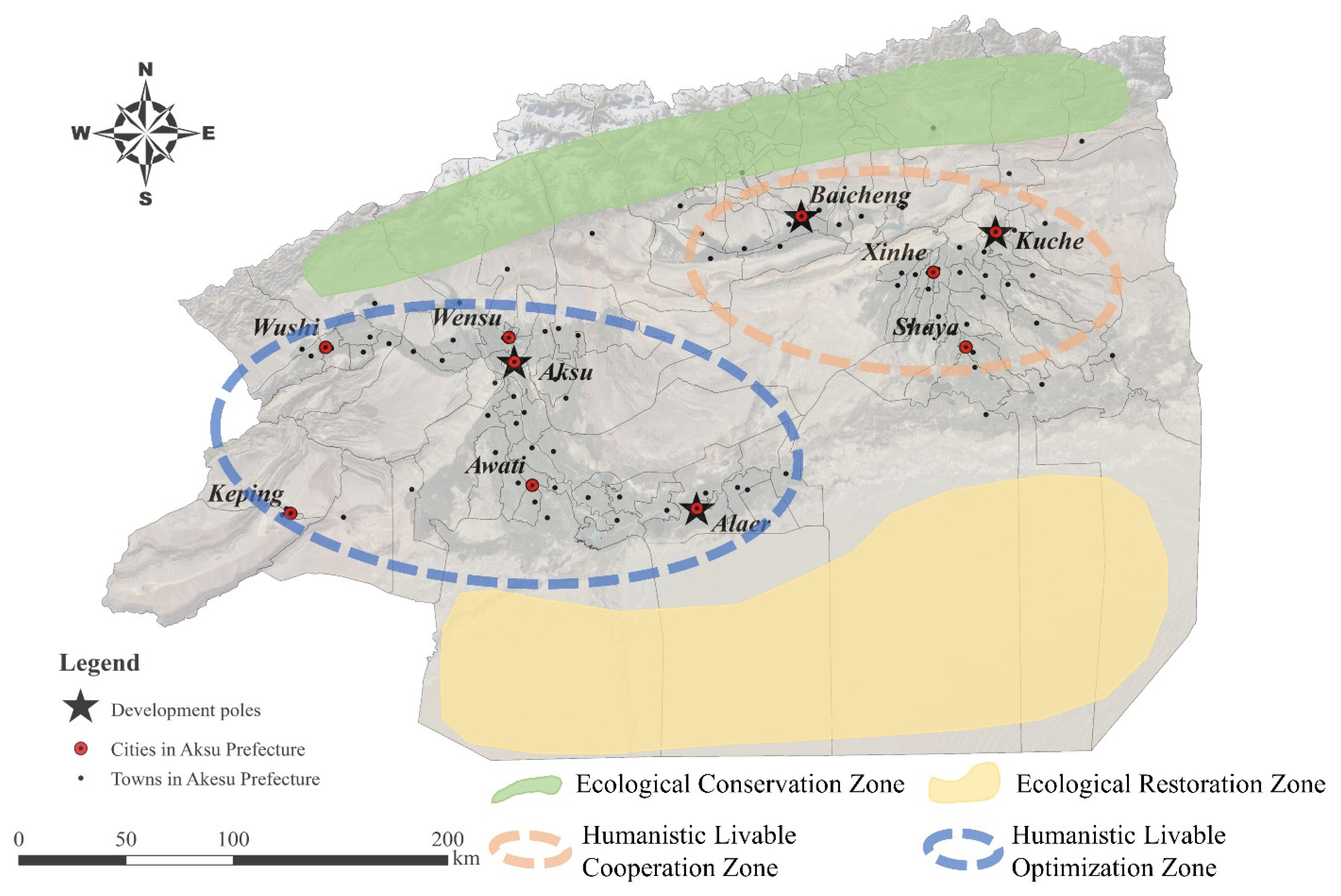
4.3. Improvement and Optimization Suggestions

Based on the previous analysis and with reference to the “Land Spatial Planning of Aksu Prefecture (2020–2035)” [55], this study defines four promotion zones: Ecological Conservation Zone, Ecological Restoration Zone, Humanistic Livable Cooperation Zone and Humanistic Livable Optimization Zone (Figure 8). The previous part of the natural livability analysis found that the ecological security of the northern Aksu prefecture is excellent, and at the same time, it is less disturbed by human activities. Therefore, the northern Aksu prefecture is designated as the Ecological Conservation Zone. In this zone, attention should be paid to water and soil conservation to prevent water and soil loss and protect the basis for the survival of vegetation. According to the previous investigation, in recent years, the ice and snow melt water has increased in the northern mountainous area of Aksu region, and debris flow disasters have occurred frequently. The local government should also do a good job in governance and protection to protect the personal safety of the township residents in front of the mountain. The Ecological Restoration Zone is located in the south of Aksu prefecture and has poor natural livability, mainly due to the large area distribution of the desert. Affected by the Taklimakan Desert, the towns in the southern Aksu prefecture are influenced by sand and dust all year round, and the living standards of the residents have been seriously impaired. In this zone, windbreak and sand fixation should be done, the original vegetation should be protected, and the ecological maintenance function should be restored by planting drought-tolerant plants such as Haloxylon ammodendron.
Humanistic Livable Cooperation Zone and Humanistic Livable Optimization Zone are delineated based on the location of the two oases in the Aksu prefecture and the characteristics of livable quality. The main role of Humanistic Livable Cooperation Zone is to promote the balanced improvement of the livable quality through the radiation effect of the Aksu and Alar development poles on other towns. In this zone, there are two counties, Wushi and Keping, where the development of livable quality is relatively backward. Their own development power is insufficient, and they need the assistance of external power to develop. First of all, the radiation effect of development poles on other towns should be strengthened, especially the centrality of Aksu Urban Area in the zone. In addition, in the process of strengthening the development poles, attention should be paid to the balanced distribution of resources to prevent the imbalance in the development of livable quality in towns. Humanistic Livable Optimization Zone is located in the oasis area in the eastern part of Aksu prefecture. Due to its far distance from the administrative center of prefecture, it needs stronger self-development motivation. Townships in this zone should focus on the layout of advantageous industries, introduce emerging industries while giving full play to the advantages of traditional brands, and improve the industrial layout system. In addition, the townships in the zone are relatively concentrated in space, and it is possible to consider the joint establishment of industrial parks of different types and levels to give full play to the leading role of the development poles.

5. Conclusions

This study proposed a comprehensive assessment framework based on natural and humanistic suitability to measure the livable quality of townships in Aksu prefecture. By means of spatial analysis and econometric analysis, combined with field research, this paper revealed the spatial distribution and relationship of townships’ livable quality from two aspects. This study can provide a reference for the evaluation and optimization of livable quality in arid oasis areas. The main conclusions are as follows: (1) At the regional level, the ecological security pattern in Aksu prefecture is good, with only a small area of ecologically fragile areas in the west and southeast. In terms of humanistic livability, Kuche City performed the best, and Keping County performed the worst. (2) From the township level, Laohutai Town has the best natural livability level, and Kuche Urban Area has the best performance of humanistic livability. The urban area with the best livable quality performance is Kucha Urban Area, and the township with the best performance is Wuzun Town. In terms of spatial distribution pattern, townships with excellent and good livable quality are concentrated and contiguously distributed. However, the spatial connection between the four urban areas with excellent livable quality and other townships is weak, and the radiation range is small. (3) Based on the measurement results and research analysis, this study defines four promotion zones: Ecological Conservation Zone, Ecological Restoration Zone, Humanistic Livable Cooperation Zone, and Humanistic Livable Optimization Zone. According to the zoning, we put forward some optimization suggestions, in order to provide reference for the improvement of the livable quality of Aksu prefecture.
Previous studies on the quality of rural livability in Xinjiang were few, and most of them were analyzed in the form of questionnaires. Because of the lack of statistical data at the township level in Xinjiang, there are not enough data to directly support the research. Moreover, the townships in Xinjiang are sparsely distributed and spaced far apart. Using the form of questionnaires would consume a large amount of manpower and time. Therefore, this paper proposed a new research framework: studying the livable quality at the city level, and then using the proportion of building land area to obtain the quality of livability at the township level. This study can provide a paradigm reference for other similar areas where data are scarce. In addition, although this study obtained the spatial distribution and relationship of the livable quality of townships in Aksu prefecture, the temporal evolution characteristics were not involved. In future research, we will focus on the characteristic changes on the time scale to provide a more accurate basis for the sustainable development of urban and rural livable quality.

Author Contributions

Writing—original draft, Y.W. and M.X.; writing—review and editing, H.W., B.T. and Y.Y. All authors have read and agreed to the published version of the manuscript.

Funding

This work was supported by the National Natural Science Foundation of China (41861037).

Institutional Review Board Statement

Not applicable.

Informed Consent Statement

Not applicable.

Data Availability Statement

No new data were created or analyzed in this study. Data sharing is not applicable to this article.

Acknowledgments

We would also like to acknowledge the Aksu Prefecture Bureau of Natural Resources for their assistance with our field trip.

Conflicts of Interest

We declare that we have no financial and personal relationships with other people or organizations that can inappropriately influence our work. There is no professional or other personal interest in any product, service, or company that could be construed as influencing the position presented in, or the review of the manuscript entitled.

References

  1. Doxiadis, C.A. Action for Human Settlements. Ekistics 1975, 40, 405–448. [Google Scholar]
  2. Doxiadis, C.A. An Introduction to the Science of Human Settlements; Oxford University Press: Oxford, UK, 1968. [Google Scholar]
  3. Geddes, P.; LeGates, R.; Stout, F. Cities in Evolution; Routledge: London, UK, 2021; ISBN 978-1-00-310107-9. [Google Scholar]
  4. United Nations. United Nations Conference on Human Settlements: Habitat I. Available online: https://www.un.org/en/conferences/habitat/vancouver1976 (accessed on 28 March 2022).
  5. Wu, L. Introduction to Sciences of Human Settlements; China Architecture and Building Press: Beijing, China, 2001. [Google Scholar]
  6. Global Forum on Human Settlements (GFHS). Available online: https://gfhsforum.org/2021Outcome (accessed on 24 May 2022).
  7. Ouyang, W.; Wang, B.; Tian, L.; Niu, X. Spatial Deprivation of Urban Public Services in Migrant Enclaves under the Context of a Rapidly Urbanizing China: An Evaluation Based on Suburban Shanghai. Cities 2017, 60, 436–445. [Google Scholar] [CrossRef]
  8. Kyttä, M.; Broberg, A.; Haybatollahi, M.; Schmidt-Thomé, K. Urban Happiness: Context-Sensitive Study of the Social Sustainability of Urban Settings. Environ. Plan. B Plan. Des. 2016, 43, 34–57. [Google Scholar] [CrossRef]
  9. Jiang, C.; Li, J.; Liu, J. Does Urbanization Affect the Gap between Urban and Rural Areas? Evidence from China. Socio-Econ. Plan. Sci. 2022, 82, 101271. [Google Scholar] [CrossRef]
  10. Tang, L.; Ruth, M.; He, Q.; Mirzaee, S. Comprehensive Evaluation of Trends in Human Settlements Quality Changes and Spatial Differentiation Characteristics of 35 Chinese Major Cities. Habitat Int. 2017, 70, 81–90. [Google Scholar] [CrossRef]
  11. Yi, X.; Jue, W.; Huan, H. Does Economic Development Bring More Livability? Evidence from Jiangsu Province, China. J. Clean. Prod. 2021, 293, 126187. [Google Scholar] [CrossRef]
  12. Zanella, A.; Camanho, A.S.; Dias, T.G. The Assessment of Cities’ Livability Integrating Human Wellbeing and Environmental Impact. Ann. Oper. Res. 2015, 226, 695–726. [Google Scholar] [CrossRef]
  13. Wu, L. High-Quality Development of Human Settlements and Modernization of Urban and Rural Governance. Hum. Habitat 2019, 4, 3–5. [Google Scholar]
  14. Wang, Y.; Jin, C.; Lu, M.; Lu, Y. Assessing the Suitability of Regional Human Settlements Environment from a Different Preferences Perspective: A Case Study of Zhejiang Province, China. Habitat Int. 2017, 70, 1–12. [Google Scholar] [CrossRef]
  15. Halik, W.; Mamat, A.; Dang, J.H.; Deng, B.S.H.; Tiyip, T. Suitability Analysis of Human Settlement Environment within the Tarim Basin in Northwestern China. Quat. Int. 2013, 311, 175–180. [Google Scholar] [CrossRef]
  16. Hu, Q.; Wang, C. Quality Evaluation and Division of Regional Types of Rural Human Settlements in China. Habitat Int. 2020, 105, 102278. [Google Scholar] [CrossRef]
  17. Luo, X.; Yang, J.; Sun, W.; He, B. Suitability of Human Settlements in Mountainous Areas from the Perspective of Ventilation: A Case Study of the Main Urban Area of Chongqing. J. Clean. Prod. 2021, 310, 127467. [Google Scholar] [CrossRef]
  18. Ma, L.; Liu, S.; Fang, F.; Che, X.; Chen, M. Evaluation of Urban-Rural Difference and Integration Based on Quality of Life. Sustain. Cities Soc. 2020, 54, 101877. [Google Scholar] [CrossRef]
  19. Salonen, A.O.; Åhlberg, M. Obstacles to Sustainable Living in the Helsinki Metropolitan Area. Sustain. Cities Soc. 2013, 8, 48–55. [Google Scholar] [CrossRef]
  20. Shami, M.R.; Rad, V.B.; Moinifar, M. The Structural Model of Indicators for Evaluating the Quality of Urban Smart Living. Technol. Forecast. Soc. Change 2022, 176, 121427. [Google Scholar] [CrossRef]
  21. You, Z.; Yang, H.; Fu, M. Settlement Intention Characteristics and Determinants in Floating Populations in Chinese Border Cities. Sustain. Cities Soc. 2018, 39, 476–486. [Google Scholar] [CrossRef]
  22. Li, X.; Yang, H.; Jia, J.; Shen, Y.; Liu, J. Index System of Sustainable Rural Development Based on the Concept of Ecological Livability. Environ. Impact Assess. Rev. 2021, 86, 106478. [Google Scholar] [CrossRef]
  23. Xiao, Y.; Chai, J.; Wang, R.; Huang, H. Assessment and Key Factors of Urban Liveability in Underdeveloped Regions: A Case Study of the Loess Plateau, China. Sustain. Cities Soc. 2022, 79, 103674. [Google Scholar] [CrossRef]
  24. Chen, W.; Zhu, K.; Wu, Q.; Cai, Y.; Lu, Y.; Wei, J. Adaptability Evaluation of Human Settlements in Chengdu Based on 3S Technology. Environ. Sci. Pollut. Res. 2022, 29, 5988–5999. [Google Scholar] [CrossRef]
  25. Guan, Y.; Li, X.; Yang, J.; Li, S.; Tian, S. Spatial Differentiation of Comprehensive Suitability of Urban Human Settlements Based on GIS: A Case Study of Liaoning Province, China. Environ. Dev. Sustain. 2022, 24, 4150–4174. [Google Scholar] [CrossRef]
  26. Wang, Y.; Zhu, Y.; Yu, M. Evaluation and Determinants of Satisfaction with Rural Livability in China’s Less-Developed Eastern Areas: A Case Study of Xianju County in Zhejiang Province. Ecol. Indic. 2019, 104, 711–722. [Google Scholar] [CrossRef]
  27. Zhao, X.; Sun, H.; Chen, B.; Xia, X.; Li, P. China’s Rural Human Settlements: Qualitative Evaluation, Quantitative Analysis and Policy Implications. Ecol. Indic. 2019, 105, 398–405. [Google Scholar] [CrossRef]
  28. Li, F.; Ye, Y.; Song, B.; Wang, R. Evaluation of Urban Suitable Ecological Land Based on the Minimum Cumulative Resistance Model: A Case Study from Changzhou, China. Ecol. Model. 2015, 318, 194–203. [Google Scholar] [CrossRef]
  29. Li, Q.; Zhou, Y.; Yi, S. An Integrated Approach to Constructing Ecological Security Patterns and Identifying Ecological Restoration and Protection Areas: A Case Study of Jingmen, China. Ecol. Indic. 2022, 137, 108723. [Google Scholar] [CrossRef]
  30. Geospatial Data Cloud. Available online: http://www.gscloud.cn (accessed on 28 March 2022).
  31. Data Center for Resources and Environmental Sciences of the Chinese Academy of Sciences. Available online: https://www.resdc.cn (accessed on 28 March 2022).
  32. Fu, Y.; Shi, X.; He, J.; Yuan, Y.; Qu, L. Identification and Optimization Strategy of County Ecological Security Pattern: A Case Study in the Loess Plateau, China. Ecol. Indic. 2020, 112, 106030. [Google Scholar] [CrossRef]
  33. Zhang, Y.-Z.; Jiang, Z.-Y.; Li, Y.-Y.; Yang, Z.-G.; Wang, X.-H.; Li, X.-B. Construction and Optimization of an Urban Ecological Security Pattern Based on Habitat Quality Assessment and the Minimum Cumulative Resistance Model in Shenzhen City, China. Forests 2021, 12, 847. [Google Scholar] [CrossRef]
  34. Dai, L.; Liu, Y.; Luo, X. Integrating the MCR and DOI Models to Construct an Ecological Security Network for the Urban Agglomeration around Poyang Lake, China. Sci. Total Environ. 2021, 754, 141868. [Google Scholar] [CrossRef]
  35. Wang, C.-N.; Le, T.Q.; Chang, K.-H.; Dang, T.-T. Measuring Road Transport Sustainability Using MCDM-Based Entropy Objective Weighting Method. Symmetry 2022, 14, 1033. [Google Scholar] [CrossRef]
  36. Meng, Y.; Chen, L.-S. Evaluation of Urban Competitiveness in Environmental Protection Zones Based on Principal Component Analysis (Pca) and Entropy Method. J. Environ. Prot. Ecol. 2021, 22, 182–188. [Google Scholar]
  37. Wang, F.; Lu, Y.; Li, J.; Ni, J. Evaluating Environmentally Sustainable Development Based on the PSR Framework and Variable Weigh Analytic Hierarchy Process. Int. J. Environ. Res. Public Health 2021, 18, 2836. [Google Scholar] [CrossRef]
  38. He, Y.X.; Jiao, Z.; Yang, J. Comprehensive Evaluation of Global Clean Energy Development Index Based on the Improved Entropy Method. Ecol. Indic. 2018, 88, 305–321. [Google Scholar] [CrossRef]
  39. Zhao, J.; Ji, G.; Tian, Y.; Chen, Y.; Wang, Z. Environmental Vulnerability Assessment for Mainland China Based on Entropy Method. Ecol. Indic. 2018, 91, 410–422. [Google Scholar] [CrossRef]
  40. Nie, W.; Shi, Y.; Siaw, M.J.; Yang, F.; Wu, R.; Wu, X.; Zheng, X.; Bao, Z. Constructing and Optimizing Ecological Network at County and Town Scale: The Case of Anji County, China. Ecol. Indic. 2021, 132, 108294. [Google Scholar] [CrossRef]
  41. Zhu, K.; Chen, Y.; Zhang, S.; Yang, Z.; Huang, L.; Lei, B.; Li, L.; Zhou, Z.; Xiong, H.; Li, X. Identification and Prevention of Agricultural Non-Point Source Pollution Risk Based on the Minimum Cumulative Resistance Model. Glob. Ecol. Conserv. 2020, 23, e01149. [Google Scholar] [CrossRef]
  42. Mahdevari, S.; Shahriar, K.; Esfahanipour, A. Human Health and Safety Risks Management in Underground Coal Mines Using Fuzzy TOPSIS. Sci. Total Environ. 2014, 488–489, 85–99. [Google Scholar] [CrossRef]
  43. Yang, T.; Zhang, Q.; Wan, X.; Li, X.; Wang, Y.; Wang, W. Comprehensive Ecological Risk Assessment for Semi-Arid Basin Based on Conceptual Model of Risk Response and Improved TOPSIS Model-a Case Study of Wei River Basin, China. Sci. Total Environ. 2020, 719, 137502. [Google Scholar] [CrossRef]
  44. Shang, Q.; Deng, Y.; Cheong, K.H. Identifying Influential Nodes in Complex Networks: Effective Distance Gravity Model. Inf. Sci. 2021, 577, 162–179. [Google Scholar] [CrossRef]
  45. Yi, K.; Zhang, D.; Zhang, L.; Ji, H.; Xiao, J. Paths and Strategies to Drive MICE into Tourism Based on Gravity Model and Wilson Model: A Case Study of Jiangxi Province in China. Arab. J. Geosci. 2020, 13, 1233. [Google Scholar] [CrossRef]
  46. Liu, E.; Wang, Y.; Chen, W.; Chen, W.; Ning, S. Evaluating the Transformation of China’s Resource-Based Cities: An Integrated Sequential Weight and TOPSIS Approach. Socio-Econ. Plan. Sci. 2021, 77, 101022. [Google Scholar] [CrossRef]
  47. Xu, X.; Zhang, Z.; Long, T.; Sun, S.; Gao, J. Mega-City Region Sustainability Assessment and Obstacles Identification with GIS–Entropy–TOPSIS Model: A Case in Yangtze River Delta Urban Agglomeration, China. J. Clean. Prod. 2021, 294, 126147. [Google Scholar] [CrossRef]
  48. Li, Y.; Sun, X.; Zhu, X.; Cao, H. An Early Warning Method of Landscape Ecological Security in Rapid Urbanizing Coastal Areas and Its Application in Xiamen, China. Ecol. Model. 2010, 221, 2251–2260. [Google Scholar] [CrossRef]
  49. Su, S.; Li, D.; Yu, X. Assessing Land Ecological Security in Shanghai (China) Based on Catastrophe Theory. Stoch. Environ. Res. Risk Assess. 2011, 25, 737–746. [Google Scholar] [CrossRef]
  50. Xue, X.G.; Li, L. Research on Coordination Degree of Economic Development and Human Settlements Environment Based on PCA for Guizhou. Adv. Mater. Res. 2014, 962–965, 2055–2060. [Google Scholar]
  51. Davidescu, A.A.; Apostu, S.A.; Pantilie, A.M.; Amzuica, B.F. Romania’s South-Muntenia Region, towards Sustainable Regional Development. Implications for Regional Development Strategies. Sustainability 2020, 12, 5799. [Google Scholar] [CrossRef]
  52. Mitrica, B.; Sageata, R.; Mocanu, I.; Grigorescu, I.; Dumitrascu, M. Competitiveness and Cohesion in Romania’s Regional Development: A Territorial Approach. Geod. Vestn. 2021, 65, 440–458. [Google Scholar] [CrossRef]
  53. Anbari, M.; Malaki, A. Social Effects of Industrial Growth Poles on Local Sustainable Development: Assaluyeh Industrial Growth Poles Case Study. Community Dev. Rural Urban Communities 2012, 3, 87–106. [Google Scholar]
  54. Dobrescu, E.M.; Dobre, E.M. Theories Regarding the Role of the Growth Poles in the Economic Integration. Procedia Econ. Financ. 2014, 8, 262–267. [Google Scholar] [CrossRef] [Green Version]
  55. Land Spatial Planning of Aksu Prefecture (2020–2035). Available online: http://www.aks.gov.cn/DFS/file/2022/06/06/20220606124729927rxnl6n.pdf (accessed on 28 March 2022).
Figure 1. The geographical position of Aksu prefecture in China.
Sustainability 14 07728 g001
Figure 2. Spatial distribution of natural livable quality in Aksu prefecture.
Sustainability 14 07728 g002
Figure 3. The humanistic livable quality of cities in Aksu prefecture.
Sustainability 14 07728 g003
Figure 4. Natural livable quality of towns in Aksu prefecture.
Sustainability 14 07728 g004
Figure 5. Humanistic livable quality of towns in Aksu prefecture.
Sustainability 14 07728 g005
Figure 6. Livable quality of towns in Aksu prefecture.
Sustainability 14 07728 g006
Figure 7. Gravitational radiation effect of development poles.
Sustainability 14 07728 g007
Figure 8. Optimization scheme of livable quality.
Sustainability 14 07728 g008
Table 1. The evaluation index system of natural livable quality in Aksu prefecture.
Resistance FactorUnitIndex
Type
Grade of Resistance CoefficientWeight/%
1020304050
Elevationkm+[0, 1.4)[1.4, 2.1)[2.1, 3.0)[3.0, 4.0)[4.0, ∞)14.61
Slope(°)+[0, 5)[5, 10)[10, 20)[20, 30)[30, ∞)14.14
NDVI/[0.8, ∞)[0.5, 0.8)[0.25, 0.5)[0.1, 0.25)[0, 0.1)10.65
Soil erosion degree/+micromildmoderateserioussevere12.33
Annual precipitationmm[137, ∞)[113, 137)[89, 113)[65, 89)[41, 65)11.60
Days of floating dustdays/year+[0, 31)[31, 40)[40, 50)[50, 60)[60, ∞)12.54
Number of earthquakes (≥3.0)times/year+[0, 1)[1, 4)[4, 13)[13, 15)[15, ∞)13.58
Distance from main roadkm[15, ∞)[8, 15)[5, 8)[2, 5)[0, 2)10.55
Table 2. The evaluation index system of humanistic livable quality in Aksu prefecture.
The SubsystemIndicatorsUnitIndex TypeWeight/%
Economic developmentPer capita GDPYuan+9.77
Per capita annual incomeYuan+7.74
Culture and educationStudent-teacher ratioStudent/teacher8.82
Number of literary and artistic institutionsInstitution+8.47
TransportationCar ownershipCar+10.21
Urban road lengthkm+9.92
Public infrastructureRate of television%+7.02
Green areahm2+10.03
Length of water supply and drainage pipeskm+9.55
Health and medical securityNumber of people with basic
medical insurance
People+9.38
Number of beds in medical institutionsBed+9.09
Table 3. The ecological cost distance of townships in Aksu prefecture.
TownEcological Cost
Distance
Ranking TownEcological Cost
Distance
Ranking
Laohutai Town0.1361……Gulawati Town9.62391
Yakra Town0.5312Bixibag Town10.01892
Yimum Town0.5353Yuerqi Town10.39193
Autobash Town0.6734allahag town10.53994
Wushi Urban Area0.8355Gulebag Town10.82695
Tumusuke Town0.9196Qiman Town11.27896
Jinyang Town17Gaizikumu Town11.58497
Tagrak Town1.028Tarim Town12.71498
Chagrak Town1.029Keping Urban Area13.37299
Arg Town1.02410Gaizlik Town22.257100
Table 4. The humanistic livable quality of townships in Aksu prefecture.
TownValueRanking TownValueRanking
Kuche Urban Area0.9461……Gaizikumu Town0.02191
Wuzun Town0.8602Bageturgeluc Town0.01892
Aksu Urban Area0.7283Yamansu Town0.00993
Ayikule Town0.6624Autobash Town0.00894
Alaer Urban Area0.6605Gaizlik Town0.00795
Baicheng Urban Area0.6336Yuerqi Town0.00596
Shaya Urban Area0.6187Tamuturgeluc Town0.00297
Yaha town0.6128Wigan Town0.00298
Chang’an Town0.6009Gongtsingtuan Town0.00299
Wensu Urban Area0.58410Yakra Town0.001100
Table 5. The livable quality of Urban Areas and towns in Aksu prefecture.
Urban AreaValueRankingTownValueRanking
Kuche Urban Area0.9461Wuzun Town0.784 1
Baicheng Urban Area0.7822Mijik Town0.773 2
Alaer Urban Area0.7813Toyburghledi Town0.771 3
Akesu Urban Area0.7634Chang’an Town0.763 4
Shaya Urban Area0.7225Ayikule Town0.741 5
Wensu Urban Area0.7046……
Wushi Urban Area0.6687Yuerqi Town0.270 87
Xinhe Urban Area0.6178Tarim Town0.262 88
Awati Urban Area0.5529Gaizikumu Town0.252 89
Keping Urban Area0.33310Gaizlik Town0.003 90
Publisher’s Note: MDPI stays neutral with regard to jurisdictional claims in published maps and institutional affiliations.

