Abstract
This study aimed to identify the nature of variable groundwater salinity from the standpoint of whether natural or man-caused factors have a dominant impact on the modern salinity range of the Lower Jurassic sediments in the Talinskoye oilfield of West Siberia in Russia. As of now, the salinity values of reservoir waters vary from 3.7 to 15.3 g/dm3, with an average of 8.9 g/dm3. Petroleum hydrocarbons are extracted at the oilfield from the Lower Jurassic sediments. The volume of overlying sediments’ waters injected into the pay zones to maintain the formation pressure was more than 8960.3 thousand m3 between 2014 and 2021. In this regard, it is necessary to establish whether anthropogenic factors are critical for the variability in groundwater salinity of the Lower Jurassic sediments, or the complex geologic and hydrogeologic conditions are determinant factors affecting the salinity variability. To achieve this objective, we evaluated the genetic coefficients of various types of waters (inclusive of injected waters) which could contribute to the variability in groundwaters with varying quantities and ratios. The resultant genetic coefficients were compared with those of reservoir waters of the Lower Jurassic hydrogeological complex. This allowed for the conclusion that the major factors currently affecting the variable salinity of the reservoir waters of the Lower Jurassic complex are natural ones. We also assessed the relationship between the groundwater salinity values of the complex under study and basic parameters of the geologic setting, such as porosity, formation pressure, modern temperature and paleotemperature of the basement, and basement depth of burial. A tight association was found between the salinity values and porosity of the sediments (R = 0.87), and a very tight connection between the salinity and formation pressure (R = 0.91), which, we believe, also evidences that natural factors have a dominant effect on the variability in groundwater salinity. The variability in the modern salinity values of the reservoir waters of the complex in question ensues from the continental conditions of the groundwater genesis, expelled-water exchange processes (ingress of the pore waters expelled from argillaceous deposits as geostatic pressure rises), and the intrusion of abyssal fluids along the basement fractures.
1. Introduction
The objective of the present study was to identify the nature of variability in groundwater salinity from the viewpoint of whether natural or man-caused factors have a dominant impact on the modern salinity range of the Lower Jurassic sediments in the Talinskoyeoilfield of West Siberia, Russia.
The problem and hypothesis: the researchers working in petroleum hydrogeology and ecology have been increasingly speaking of the truly huge scale of the man-caused impact on the hydrogeologic field of the West Siberian megabasin over the past two decades. More than 10 × 109 tons of oil and 11 × 1012 cubic tons of gas have been extracted from the West Siberian subsoil, and hundreds of thousands of prospecting, exploratory, and producing wells have been drilled in. The volumes of the extracted hydrocarbons are compensated by injecting underground and surface waters into the subsoil in order to support the formation pressure. These waters are distinct from reservoir waters their composition and temperature.
Petroleum hydrocarbons, which are replaced by injecting waters from the overlying sediments to maintain the formation pressure, are extracted from beds UY10 and UY11. The injected waters can consist of both reservoir waters and the associated waters that are recovered together with oil. The volume of the waters injected into the Lower Jurassic complex has been estimated by the subsoil user to be over 8960.3 × 103 m3 for the last seven years from 2014 to 2021. We are currently observing the variable groundwater salinity of the Jurassic complex: the values range from 3.7 to 15.3 g/dm3, with an average of 8.9 g/dm3. Concurrently with the man-caused impact on the groundwaters of the beds under study, the oilfield is representative of complicated geologic–hydrogeologic and tectonic conditions, which are likely to be the major cause of the variable salinity untypical of the Jurassic sediments in other oilfields of West Siberia. This is because the subsoil user fulfills all the requirements of the legislative normative acts on subsoil use regarding water pre-treatment and purification when injecting the waters into the complex. Despite that, an accurate prediction of the water-rock interactions at high depths is quite difficult.
Therefore, we believe that it is vital to find out the causes of the variable groundwater salinity of the Lower Jurassic complex. To achieve this goal, we set the following objectives:
- to reveal the likeness of the composition of various genetic types of waters with varying amounts and ratios (including the injected waters) that could contribute to the observable variability in groundwater salinity;
- to assess the relationship between the basic parameters of the geologic setting and groundwater salinity values of the complex under study.
These objectives are presented hereinafter as subsections in Methods, Results, and Discussion.
2. Methods
2.1. Geologic–Hydrogeologic Features of the Talinskoe Oilfield
The oilfield is located in the western Khanty-Mansi Autonomous Okrug in Tyumen Oblast, Russia (Figure 1). Three hydrogeologic basins are discernable in the oilfield section, same as in the entire West Siberian megabasin: the Cenozoic, Mesozoic, and Paleozoic [1,2,3].
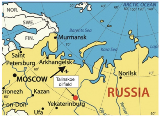
Figure 1.
The administrative location of the Talinskoe oilfield.
The UY10 and UY11 sediments under study consist of gray sandstones and gray, light-gray, and brownish-gray gravelites with rare interlayers of aleurolites and argillites. The total thickness is about 50–80 m; according to the type section, the UY10 and UY11 formation rocks are bedded about 2650–2700 m deep [4,5]; they are sealed off by aquiclude rocks of the Radomskoe clay sequence made up of bituminous argillites about 40 m thick, and separated from each other by aquiclude rocks of the Togurskaya sequence representative of lithological windows across the oilfield area. The UY10 and UY11 formations are bedded directly at the base of the sedimentary cover, on the basement (Figure 1). Therefore, we consider beds UY10 and UY11 as a single hydrodynamic system.
The basement of the sedimentary rock within the oilfield is composed of metamorphic rocks dislocated to a different extent (Figure 2). Here are found shale, carbonate–terrigenous, volcanogenic–sedimentary, and volcanogenic sediments. The said sediments are broken by numerous intrusions having acidic, less often—moderately acidic, neutral, basic and ultrabasic compositions. The presence of numerous disjunctive faults in the basement of the region, as discovered by the geophysical surveys, is described in a series of studies [5,6,7,8,9]. This is also corroborated by the distribution analysis of epigenetic mineral associations of hydrothermal origin in the Jurassic sediments of the Talinskoe oilfield [10,11].
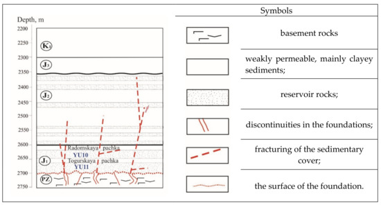
Figure 2.
A conceptual schematic of the structural geology of the oil field.
The disjunctive faults present in the basement of the region are also confirmed by the temperature-related, gaseous, and hydrogeochemical anomalies [3,12,13,14] and by palynological data [15]. Therefore, the researchers who have evaluated various aspects of the geologic conditions of the region believe that the rocks of beds UY10 and UY11 under study represent reworked secondary quartzites among which can be found quartz-dickite-kaolinite and kaolinite-dickite-quartz facies [16]. Korobov [16] notes that the hydrothermalites of these facies are concentrated in the Jurassic rocks within the large faults and feather fracturing thereof that are transverse to the basement and the sedimentary cover.
The features of geological and hydrogeological conditions of the Talinskoye oilfield may also include the proximity to the cutoff part of the West Siberian megabasin and the presence of Lower Cretaceous argillaceous deposits 750 m thick. Such deposits seal off the Jurassic sediments, creating favorable conditions for water metamorphization and active water–rock interactions in the Lower Jurassic sediments.
After rejection (that was performed in accord with many years’ experience of surveys within other West Siberian oilfields), we used 35 assayed groundwater samples for the studies within beds UY10 and UY11.
The UY10 and UY11 formation groundwaters exhibited a sodium-chloride ionic-saline composition whose formula is as follows:
Table 1 summarizes the statistical average measures of the chemical composition of reservoir waters.

Table 1.
Statistical characteristics of the groundwater composition indicators in the UY10 and UY11 formations Talinskoe oifield.
Figure 3 displays a salinity map of groundwaters contained in beds UY10 and UY11. The GST software package [17] that implements a generalized method of spline approximation was employed for the calculations and map construction outlined herein. The spline approximation methods are applicable and effective for solving many problems related to the spatial regularities of variations in properties of geologic objects.
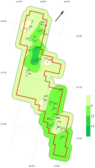
Figure 3.
A schematic map of groundwater salinity distribution in beds UY10 and UY11 of the Talinskoe oilfield. Note: the bar scale next to the schematic map shows the change in groundwater salinity. An ID number of the well from which groundwater samples were collected is indicated near the point.
Four sites having the lowest salinity of up to 6 g/dm3 can be delineated across the oilfield. Overall, such low values are untypical of the Lower Jurassic depths within the West Siberian megabasin [3,18].
2.2. Revealing the Likeness of Compositions of Various Genetic Types of Waters
The UY10 and UY11 formation groundwaters are the result of intermixing between: the sediment waters built up during sedimentation; the expelled pore waters (expelled from clays into reservoirs while the geostatic pressure is rising); the associated waters recovered together with oil from the Aptian–Albian–Cenomanian aquifer complex and injected into the Lower Jurassic complex to maintain the formation pressure upon the oil production; and the Paleozoic waters and underlain basement sediments.
The Middle-Jurassic reservoir waters of interest were subdivided into two groups with salinity values, below 7 g/dm3 and above 7 g/dm3, respectively (Table 2).
Table 2.
Statistical profile of compositional measures of the Lower Jurassic groundwaters with salinity values below and above 7 g/dm3 in the Talinskoye oilfield.
The characteristics of various water types involved in the genesis of the contemporary composition of the Lower Jurassic formation waters are listed in Table 3, Table 4 and Table 5.
Table 3.
Statistical profile of compositional measures of the Paleozoic sediment waters in the Talinskoye oilfield.
Table 4.
Statistical profile of compositional measures of the Jurassic sediment pore waters.
Table 5.
Statistical profile of compositional measures of waters injected into the Lower Jurassic complex.
The Paleozoic sediment waters underlying the Lower Jurassic complex under study were tested while exploring the oilfield (Table 3). According to Prof. V. A. Sulin, they refer to the sodium bicarbonate type waters with a salinity ranging from 3.42 to 12.99 mg/dm3, same as the Lower Jurassic sediment waters in terms of the composition.
Pore waters are those that are generated from pressuring up the Jurassic clay rocks by a hydraulic press. The samples were collected at the Kamennoye oilfield directly adjacent to the Talinskoye oilfield. Therefore, the data acquired from the experiment were used herein for a comparison with the composition of the Lower Jurassic formation waters [19] (Table 4). Due to their composition, the pore waters classified as the sodium bicarbonate type in accord with Prof. V. A. Sulin, and have a salinity ranging from 7.3 to 8.5 g/dm3.
We also evaluated the data on the composition of waters injected into the Lower Jurassic complex (Table 5). The waters are being injected into the complex to maintain the formation pressure. These waters are recovered together with oil from the overlying Aptian–Albian–Cenomanian aquifer complex. They refer to the sodium bicarbonate type as per Prof. V. A. Sulin, with their salinity ranging from 12.2 to 12.5 g/dm3.
2.3. Analysis of Relationship between Basic Parameters of Geologic Setting and Groundwater Salinity of the Complex under Study
In the course of the study, we evaluated Lower Jurassic groundwater salinity was dependent on the parameters such as porosity, formation pressure, modern and paleotemperature of the basement, and basement depth of burial. The statistical profile of the parameters used for evaluating the relationship between the basic parameters of the geologic setting and salinity values is given in Table 6.
Table 6.
Statistical profile of the geologic setting evaluated.
3. Theoretical Basics
3.1. Geologic–Hydrogeologic Features of the Talinskoye Oilfield
The Jurassic sediment groundwaters as a hydrologic object in West Siberia were explored by many researchers [3,18,20,21,22,23] but their genetic sources and the role of various geologic factors in the genesis of the chemical composition remain unclear so far. The data generalized herein allows us to refine these issues that are of importance in terms of theoretic and application aspects.
The interactions between the rock and water in beds UY10 and UY11, as in the Jurassic strata in its entirety, are distinguished by duration and full-cycle water-rock interaction. The onset of the Jurassic sediment genesis accounts for about 200.1 ± 0.2 million years, and the endset 145.0 million years [24].
The hydrologic conditions are complicated by elements of various water drive systems found in the surveyed region: lithostatic and geodynamic expelled waters. The lithostatic expelled water system produces a head of fluids when expelled from the compacting precipitations and rocks into reservoirs and, in part, when the reservoirs themselves are being compacted to expel the fluid out of higher-pressure places into less pressure and evacuate the fluids in line with the local gradient of the formation pressure. The expelled water system tends to be hydraulically closed (quasi) and the formation pressure exceeds the hydrostatic pressure [3]. In the initial paleohydrogeologic surveys of the West Siberian megabasin, the Talinskoye oilfield region corresponded exactly with the elision-based lithostatic water drive system [25] because the Mesozoic basin section had Lower Cretaceous clay rocks K1 of more than 750 m in thickness; this terrane was believed to be a source of a greater amount of expelled pore waters that had entered into the Jurassic reservoirs. In our view, elements of not only lithostatic but also geodynamic expelled water systems are present in the region. That is, there is a water drive system in which the fluid head is generated by the geodynamic pressure (tectonic tension−compression) [3], which is likely responsible for the heterogeneous salinity values of the Jurassic sediment waters.
Such a rock reworking occurred due to the exposure of high-head deep-hole fluids that had entered the sedimentary rocks in the periods of tectonic activation [14,20,26,27,28,29]. That said, the probability that the ingress of fluids from the basement across the disjunctive faults of high-temperature fluids has an impact on the hydrogeochemical conditions of the Jurassic horizons is quite high.
Using the data on location of the disjunctive faults, despite them having a doubtless impact of the geologic setting including the groundwater composition of the sedimentary-cover rocks, is difficult because the location of those faults is ambiguously interpreted by the geophysical survey data: different authors have different interpretations. We evaluated the literature reports in which the location of disjunctive faults in the oilfield basement was delineated by geophysical survey data [4,6,7,8], and we came to the conclusion that there is currently no univocal picture of the fault grid location. The subjectivity of one of the up-to-date delineation methods for disjunctive faults―the lineament analysis―is also indicated by other authors [30,31]. At the same time, these authors discovered by the lineament analysis of the Koltogorsk–Tolka zone of the West Siberian megabasin and adjacent territories that there is a relationship between the salinity distribution across all of the aquifer systems and the block structure of the sedimentary cover. Thus, despite the lack of an unambiguous picture, the impact of the presence of disjunctive faults as vertical migration channels is quite discernible.
3.2. Revealing the Likeness of the Compositions of Various Genetic Types of Waters
As mentioned above, the groundwaters of beds UY10 and UY11 arise from the intermixing between sediment waters, pore waters, and the waters injected into the Lower Jurassic complex to maintain the formation pressure of the underlying sediments (the Paleozoic sediments and basement).
According to the numerous studies on deep horizon hydrogeology ([21,31,32,33,34] etc.), a certain association between the secondary formations and the specific ion–salt composition of groundwater corresponds to each stage of the interaction of water with rocks. If one considers the paleogeographic conditions of the groundwater genesis, West Siberia in the early Jurassic age (the genesis of beds UY10 and UY11) had a continental sedimentation regime, but, in this case, the continental conditions changed repeatedly and were transitional or quite likely marine. In the Talin area, this is proved by the microfauna and microphytoplankton found in the well sections [5]. Paleogeographic areas within the territory of the field are distinguished as being erosion-denudation gently sloping plains, denudation-accumulative plains, and accumulative lacustrine-alluvial plains. The climate at the time of interest was warm and humid— a fact confirmed by the floristic and spore-dust analyses [5]. Having formed and accumulated under such paleogeographic conditions, the reservoir waters at the present moment after a complete cycle metamorphism of the composition should have had a salinity of more than 10 g/dm3 and to the chloro-calcium type (according to Prof. V. A. Sulin: rNa/rCl < 1, (rCl-rNa)/rMg > 1)), which is in progress in the central West Siberian megabasin [3,35]; but within the survey region, we do not observe such a picture, and the waters refer basically to the hydrocarbonate-sodium type as per Prof. V. A. Sulin (rNa/rCl > 1, (rNa-rCl)/rSO4 > 1). The genesis of this type of and the emergence of sites with salinity below 6−7 g/dm3 are possible due to either the sediment waters being diluted with expelled pore waters, the ingress of waters from the Paleozoic sediments and basement, or the intermixing between sediment waters and the injected waters. Such processes are described in the studies on petroleum hydrogeology performed in the Surgutskoye, Fedorovskoye, and Urengoyskoye oilfields [3,20,33].
The coefficients rNa/rCl, rCl/rHCO3, rCa+rMg/rHCO3, and rCa/rNa are used to understand the genesis of oil horizon groundwaters. The values of the components are expressed in mg-eq/dm3, as is designated by letter “r”. This form is derived by dividing the values expressed in mg-eq/dm3 by the corresponding molecular ionic weight.
The coefficients listed above allow the water metamorphization degree to be evaluated. The constant value of the rNa/rCl coefficient in the ocean is 0.87, and in the case that coefficient is in excess of 0.87 (as in the event of the UY10 and UY11 pore waters), the water solutions are considered as either low-metamorphic waters of infiltration genesis or sediment waters from desalted basins [33,36]. For the other coefficients listed, there are no classifications commonly acknowledged in petroleum hydrogeology; however, based on the experience of deep horizon testing, it is generally recognized that the higher the rCa/rNa, rCl/rHCO3, and rCa+rMg/rHCO3 coefficients, the more metamorphic or anthropogenically altered the water composition [3,18,20,22,33,36,37,38]. The most significant in that case are the rNa/rCl and rCa/rNa coefficients that reflect the water transformation degree.
3.3. Analysis of Relationship between Basic Parameters of Geologic Setting and Groundwater Salinity of the Complex under Study
It is known that checking the correlation between compositional parameters and physicochemical and geological measures (depth, temperature, pressure, groundwater discharge, composition and constitution of host rocks, distance to natural and anthropogenic objects that disturb the geochemical field, etc.) can be reckoned among simple and informative methods of refining the genesis of the chemical composition of groundwaters [31,39].
Table 7 summarizes the main reasons for selecting the parameters used in the correlation analysis of the oilfield. The choice of the parameters that were used for the data integration was reliant on the fact that the values of these parameters have a single interpretation by the field-scale and lab-scale measurements. In that case, the sedimentation conditions are the priority genetic factors affecting the contemporary composition of the water-dissolved complex [29].
Table 7.
Reasons for selecting the status parameters of the geologic setting of beds UY10 and UY11 for correlation analysis.
4. Research Methods
4.1. Revealing the Likeness of the Composition of Different Genetic Types of Waters
By the results of the analyses performed for different types of waters, as reported in the Materials (Section 2.2), the genetic coefficients rNa/rCl, rCa/rNa, rCl/rHCO3, rCa+rMg/rHCO3 were calculated for each of the type. The values of the components are expressed as mg-eq/dm3, as is designated by “r”. This form is derived by dividing the values expressed in mg-eq/dm3 by the corresponding molecular ionic weight.
We further compared the resultant coefficients of formation waters having salinities below 7 g/dm3 and above 7 g/dm3 with those derived for the pore waters, Paleozoic waters, and injected waters. This comparison allowed for the conclusion of likeness or unlikeness of the compositions of the waters differing in genetic types and hence of their possible effect on the variability in salinity of the reservoir waters.
4.2. Analysis of Relationship between Basic Parameters of Geologic Medium and Groundwater Salinity of the Complex under Study
To reveal the relationship between the salinity and parameters set out in Section 2.3, we built linear dependences y = f(x), where y is the salinity and x, respectively, is the porosity, formation pressure, modern temperature of the basement, paleotemperature of the basement, and basement depth of burial. We then evaluated how tight the association between each of those parameters and salinity was. The following classification of the correlation parameters was employed: 0.91–1 is a very tight connection; 0.71–0.90 is tight, 0.51–0.70 is moderate, and less than 0.51 is weak [40].
5. Results and Discussion
5.1. Revealing the Likeness of the Compositions of Various Genetic Types of Waters
The calculation results of the coefficients for reservoir waters (with salinity below and above 7 g/dm3), pore waters, Paleozoic waters, and injected waters are given in Table 8.
Table 8.
Genetic coefficients representative of the compositions of reservoir waters, Paleozoic waters, and injected waters.
The Lower Jurassic reservoir waters with a reduced salinity (5.17 g/dm3) are presumably closest in the ionic salt composition to the pore waters. The composition has equal portions of 76% eq. chloride ions and 95% eq. sodium and potassium ions. The rCa/rNa coefficient values coincide, 0.03. In that case, the difference in the rCa+rMg/rHCO3 is significant and is two times as low for the pore waters (1.02) as for the reservoir waters (0.41). In the same manner, the rCl/rHCO3 coefficients differ by 2.6 times (3.7 for reservoir waters with reduced salinity and 9.5 for pore waters). Presumably, the pore waters that have been widespread within the survey region due to the development of the water drive system exerted a significant effect on the genesis of the ionic salt composition of the reduced-salinity reservoir waters of the Lower Jurassic complex.
The ratio of ions in the reservoir waters of the Lower Jurassic hydrogeological complex with a salinity of 10.44 g/dm3 is quite close to that in the Paleozoic waters and injected waters. First of all, this concerns the portion of chloride ions involved. Also, the values of the rNa/rCl genetic coefficient are almost the same: 1.09 for reservoir waters, 1.03 for the Paleozoic groundwaters, and 1.09 for the injected waters; and the rCa/rNa coefficient was 0.04 for reservoir waters, 0.04 for the Paleozoic groundwaters, and 0.05 for the injected waters. The rCl/rHCO3 and rCa+rMg/rHCO3 coefficients differ significantly. In our opinion, these differences are explained by the aggregate influence of the other factors and by the action of fluid-hydrogeodynamic processes that were “superimposing” on the water-rock interaction throughout the development history of the territory.
The rCa+rMg/rHCO3 coefficient for the injected waters differs significantly from that for the other water types that have become widespread in this complex. In all the other types of waters, this coefficient ranges from 0.41 to 1.02, which most likely indicates a dominant impact of the natural factors on the salinity variability.
In terms of the most meaningful genetic coefficients, the Lower Jurassic reservoir waters with reduced salinity are close to the pore waters, while the reservoir waters with a salinity above 7 g/dm3 are similar to the Paleozoic and injected waters. Thus, the emergence of the desalination sites of the Lower Jurassic complex is most likely associated with the functioning of the expelled water system, the expelled pore water. The desalination processes of the groundwaters when expelled in the central and northern regions of West Siberia are described in the studies on the genesis of groundwaters [3,24,34].
The variability of the groundwater salinity of the complex is currently not significantly affected by the injection of water from the overlying sediments. Similar results were obtained for the Aptian–Albian–Cenomanian complex of the Mesozoic basin (based on the analysis of 3185 samples for the entire period) for a number of oilfields in Western Siberia [41]. Observations of the chemical composition of groundwater confirmed the stability of the hydrochemical conditions of the Aptian–Albian–Cenomanian complex despite 196.2 million m3 of produced water pumped into the complex.
5.2. Analysis of Relationship between Basic Parameters of Geologic Medium and Groundwater Salinity of the Complex under Study
The calculation results of the correlation coefficients for the salinity of the Lower Jurassic formation waters, as well as for porosity, formation pressure, modern temperature of the basement, paleotemperature of the basement, and basement depth are given in Table 9.
Table 9.
Coefficients of the correlation between groundwater salinity of beds UY10 and UY11 and the parameters of the geologic medium.
Based on the correlation coefficient values, a tight relationship was found between the salinity values and porosity of the sediments (R = 0.87, M = −2.33n + 44.63), and a very tight relationship was found between the salinity and the formation pressure (R = 0.91, M = 2.78P − 60.11). The connections between the salinity and the other parameters are classified as being weak.
A plot of the relationship between the mineralization and porosity of beds UY10 and UY11 is shown in Figure 4. An inverse relationship was obtained between these parameters: the higher the porosity, the lower the salinity. The close relationship may be the presence of deep high-temperature, low-mineralized fluids during the geological history of the West-Siberian megabasin, the composition of which is low-mineralized and highly active [33,42,43,44]. There were intrusions of the high-temperature, low-mineralized deep fluids whose impact led to a dissolution of the rock-forming minerals (which increased the porosity in the general case) and to a dissolution of the initially buried sediment solutions.
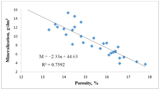
Figure 4.
Groundwater salinity of beds UY10 and UY11 plotted against porosity.
Processes previously conducted studies on the mineralogical composition of the Lower Jurassic sediments of the Talinskoe oilfield, the results of which [45] show that for the considered deposits the dissolution process manifests itself widely enough and affects the framework, plastic, and chemogenic components. At the same time, the intensity of dissolution is different: small pores and caverns are fixed on some feldspar grains, while others are completely dissolved. Prof. Tyumentsev [28] pointed out that the circulation of heated formation water, which forms a large number of pore channels, could explain the improvement in reservoir properties of the Jurassic deposits in the study area.
A close relationship has also been identified between groundwater salinity and reservoir pressure. A graph of the relationship between these parameters is shown in Figure 5. The formation pressures measured in the same interval as the salinity vary from 22.75 MPa to 27.11 MPa (an average of 24.91 MPa). The lowest salinity values correspond to low pressures, while the higher values correspond to the higher pressures, i.e., the resultant relationship is straightforward.
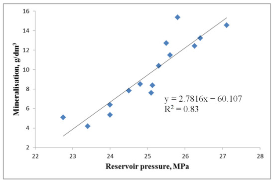
Figure 5.
A relationship between the salinity of beds UY10 and UY11 and the formation pressure.
The detected dependence is seemingly not correspondent to the elision theory [3,21,33], which states that the formation pressure can increase within the zones where the waters are expelled mostly from the clayey sediments into the reservoir strata as the overlying sediment burden increases, with the salinity of the buried sediment waters declining [3,40,44]. Had only elision processes acted in the region, the reservoir pressure–salinity relationship would have been inverse rather than direct. But at the same time, the sites with elevated pressure and salinity are the elements of a post-elision water pressure system, i.e., a water pressure system formed from the elision system when the elision water expelling processes are attenuated. In such systems, groundwater salinity increases due to the closure. Post-elision systems were described by the researchers in petroleum hydrogeology [42]; they are characterized by impeded water exchange and low mobility of reservoir waters. The said processes reflected in the reservoir water salinity originated from the effect of continental factors. However, to explain the relationship identified, it is necessary to consider geodynamic conditions: according to the survey data on the gravity field [7,25,46,47,48], a stretching zone of the Earth’s crust is documented in the oilfield region. Therefore, it is likely that sediment waters were being “sucked” into the disjunctive faults of the basement throughout the tectonic development of the territory, which was alternating with the ingress of low-salinity deep fluids along the basement faults. The model of the hydrogeological field genesis in such a manner was described by V. I. Dunin and called a pulsation-fluid-thermodynamic model [20]. If one accepts this development model, faults in the sedimentary cover and basement are the fluid vertical migration pathways. We believe that elements of post-elision and geodynamic elision water-retaining systems are currently observed in the Jurassic sediments of the oilfield.
The correlation relationship established between the groundwater salinity of beds UY10 and UY11 with modern temperature and paleotemperature is classified as weak (Tmodern—M: R = 0.17; Tpaleo—M: R = 0.1). Distribution maps of modern and paleotemperatures of the basement are shown in Figure 6 and Figure 7. When comparing the distribution of modern and paleotemperatures of the basement (Figure 7 with the salinity field of beds Yu10 and Yu11 (Figure 3), no correlation between the areas of low (or increased) salinity and elevated (decreased) temperatures is observed. It is known that most of the processes that form and transform the composition of groundwater (rock leaching, cation exchange, diffusion, etc.) are significantly accelerated as the temperature increases. In the classical view, increasing temperature contributes to the accumulation of ions in the composition of sedimentogenic water and increasing salinity as aquifers deepen, but even this notion is not confirmed within the survey region. According to the correlation analysis performed in [20] for the Upper Jurassic deposits of the north-eastern Shirotny Priob’ye of West Siberia (located east of the survey region), the impact of the geothermal regime of mineral resources on the chemical composition of groundwater is also likely to have a subordinate character at the present stage of the territory development. The obtained weak dependence is a consequence of the post-elision system and, probably, the attenuated neotectonic processes at the present stage of development of the West Siberian megabasin.
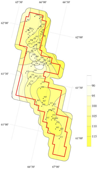
Figure 6.
A schematic map of the distribution of modern basement temperatures in the Talinskoe oilfield. Note: the bar scale next to the schematic map shows the change in modern basement temperatures. An ID number of the well wherefrom the modern basement temperature was measured is indicated near the point.
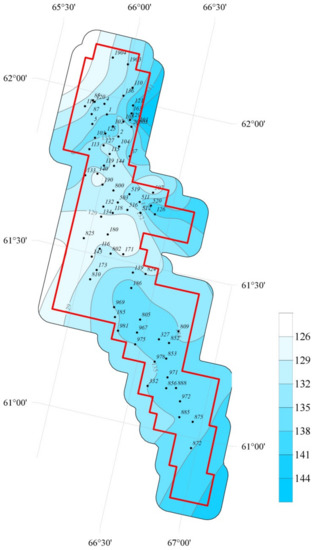
Figure 7.
A schematic map of basement paleotemperature distribution in the Talinskoe oilfield. Note: the bar scale next to the schematic map shows the change in paleotemperature distribution. An ID number of the well wherefrom paleotemperature was measured is indicated near the point.
The relationship between the salinity and basement depth (R2 = 0.49) is also classified as weak. This factor is probably not reflected in the modern field of the Jurassic groundwater salinity and its action has weakened during the geologic development of West Siberian megabasin.
6. Conclusions
1. The groundwaters of the Jurassic beds UY10 and UY11 in the Talinskoe oilfield of the West Siberian megabasin are classified as sodium chloride waters by the ion–salt composition and as hydrocarbonate-sodium type as per Prof. V. A. Sulin (rNa/rCl > 1, (rNa-rCl)/rSO4 > 1) based on 35 sample assays. The salinity map plotted by the salinity values demonstrates a heterogeneous salinity distribution field. Its average is 8.9 g/dm3, with a variation range from 3.7 to 15.3 g/dm3. The values of sodium-chlorine and chlorine-bromine coefficients averaged 1.17 and 167.90, respectively, indicating a sufficiently high degree of metamorphization of the water composition.
2. The analysis of the study results for deep oil-and-gas-bearing horizons in West Siberia, carried out during the last decades by different authors, has revealed two basic groups of viewpoints on possible causes of the genesis of a heterogeneous salinity field within the survey region: expelled water exchange (ingress of expelled pore waters from clays into reservoirs as the geostatic pressure increases and dilution initially buried sedimentary waters are diluted with those waters), and a periodic ingress of high-temperature, low-mineralized deep fluids along the basement faults (that have also diluted the sediment waters that caused catagenic transformations in the water-rock system and consequently decreased the salt concentration of the groundwaters). The groundwaters of the Lower Jurassic complex are the result of mixing and interaction between the sediment waters accumulated together with the sediment, expelled pore waters, Paleozoic deep waters, and deep waters periodically coming from the basement. Due to waters being injected from the overlying sediments to maintain the formation pressure, the ingress of this water type also affects the water composition.
3. The values of the most significant genetic coefficients of the Lower Jurassic reservoir waters having a reduced salinity are close to those of the pore waters: genetic coefficients rNa/rCl were 1.3 and 1.24, respectively, and rCa/rNa was 0.03. The Lower Jurassic reservoir waters with a salinity of more than 7 g/dm3 are the closest in composition to the Paleozoic sediment waters and injected waters: the rNa/rCl coefficient was 1.09 for reservoir waters with an elevated salinity, 1.03 for Paleozoic sediment waters, and 1.09 for injected waters; the rCa/rNa coefficient for these three types of waters was 0.04–0.05. The obtained coefficients make it possible to assume that the effect of natural factors at this stage of development prevails over the effect of the technogenic factor—the injection of associated waters from the overlying deposits. The calculated genetic coefficients for the injected waters enable us to attest that the injected waters currently do not have a significant impact on the variability in the salinity of the Lower Jurassic reservoir waters, which is likely due to their composition being similar to that of the reservoir waters.
4. Analysis of the relationship between the basic parameters of the geologic medium and the groundwater salinity values of the complex under study revealed that a close relationship is observable between the salinity values and the deposit porosity of (R = 0.87) and a very close relationship is observable between salinity and formation pressure (R = 0.91), which also confirms the natural factors have a dominant impact on the salinity variability than the technogenic factors. The obtained correlation coefficients indicate that the genesis of reduced salinity values of groundwaters in the region is a consequence of continental conditions of groundwater genesis, such as expelled water exchange processes for which favorable natural conditions were originally created (the presence of Lower Cretaceous clayey sediments over 750 m thick, a layered nature of the “clayey sediments-reservoir” section). The intrusion of deep fluids along the faults contributed to the contrasting salinity values. To the disjunctive faults are confined hydrochemical and thermal anomalies which are fading outside the activation period of neotectonic processes—what we are likely observing.
5. The UY10 and UY11 groundwaters have probably been generated chiefly by the impact of continental factors on which water expelling processes and the intrusion of deep fluids from the basement were subsequently superimposed; the injection of associated waters from the overlying sediments does not have a significant effect on the variability in groundwater salinity of the Lower Jurassic hydrogeologic complex.
Elements of the so-called post-elision [40,41] and elements of the geodynamic elision water systems are observed in the survey area. The natures and functioning of these systems are described elsewhere [25,40,44,47]. The modern groundwater salinity values of beds Yu10 and Yu11 directly underlying the West Siberian megabasin basement at the Talinskoe oilfield ensue from the action of complex natural processes; the technogenic factors are currently not the cause of the genesis of variability in groundwater salinity of the Jurassic hydrogeologic complex.
Author Contributions
Conceptualization, R.N.A.; methodology, R.N.A.; validation, M.A.K.; formal analysis, R.N.A.; investigation, R.N.A.; writing—original draft preparation, R.N.A.; writing—review and editing, R.N.A., M.A.K.; visualization, M.A.K.; supervision, M.A.K. All authors have read and agreed to the published version of the manuscript.
Funding
This research received no external funding.
Institutional Review Board Statement
Not applicable.
Informed Consent Statement
Not applicable.
Data Availability Statement
The data that support the findings of this study are available from the corresponding author upon reasonable request.
Acknowledgments
The authors greatly acknowledge to M.V. Itskovich (Candidate of Geomineralogical Sciences), A.G. Plavnik (Geomineralogical Sciences), L.A. Abukova (Geomineralogical Sciences), V.A. Belkina (Candidate of Geomineralogical Sciences), L.A. Kovyatkina from the Tyumen Industrial University, L.M. Zakharova (Candidate of Geomineralogical Sciences) from the Shpilman Scientific and Analytical Centre for Subsoil Management, and A.G. Mukher (Candidate of Geomineralogical Sciences) for consultations and assistance in the preparation of the article. The article is published with the grant support of Tyumen Industrial University and prepared as part of the Digital Core Technology project at the West-Siberian Interregional World-class Science and Education Centre.
Conflicts of Interest
The authors declare no conflict of interest.
References
- Abdrashitova, R.N.; Salnikova, Y.I. Structure of the hydrogeological field of the Krasnoleninsky arch. IOP Conf. Series Earth Environ. Sci. 2018, 181, 012001. [Google Scholar] [CrossRef]
- Matusevich, V.M.; Kovyatkina, L.A.M.; Kovyatkina, L.A. Hydrogeological stratification of the West Siberian megabasin according to new data. In Development of the Mineral Resource Base of Siberia; Obruchev, V.A., Usov, M.A., Urvantsev, N.N., Eds.; National Research Tomsk Polytechnic University Press: Tomsk, Russia, 2013; pp. 528–531. (In Russian) [Google Scholar]
- Matusevich, V.M.; Rylkov, A.M.; Rylkov, A.V.; Ushatinskiy, I.N. Geofluidal Systems and Problems of Oil and Gas Bearing Capacity of West Siberian Megabasin; Tyumen Industrial University Press: Tyumen, Russia, 2005; 225p. (In Russian) [Google Scholar]
- Bembel, S.R.; Bembel, R.M.; Avershin, R.V.; Kornev, V.A. Prospects for Identifying Productive Areas in Jurassic Sediments in Areas of the Frolov Oil and Gas Bearing Region, Geology. Prospect. Explor. Oil Gas Fields 2018, 4, 7–14, (In Russian with English Abstract). Available online: https://cyberleninka.ru/article/n/perspektivy-vydeleniya-produktivnyh-uchastkov-v-yurskih-otlozheniyah-na-ploschadyah-frolovskoy-neftegazonosnoy-oblasti (accessed on 23 February 2022).
- Mukher, A.G. Geological Structure and Oil and Gas Content of the Jurassic of Western Siberia. Selected Works; Tyumen IzdatNaukaServis: Tyumen, Russia, 2018; 524p. (In Russian) [Google Scholar]
- Shpilman, A.V. Atlas of Geology and Oil-and-Gas Bearing Capacity of Khanty-Mansiysk Autonomous District; Shpilman National Research Centre: Khanty-Mansiysk, Russia, 2004; 150p. (In Russian) [Google Scholar]
- Bembel, R.M.; Megeria, V.M.; Bembel, S.R. Geosolitons: A Functional Earth System, Hydrocarbon Exploration and Development Concept; Vector Book: Tyumen, Russia, 2003; 344p. (In Russian) [Google Scholar]
- Radchenko, A.V.; Martynov, O.S.; Matusevich, V.M. Dynamically Stressed Zones of Lithosphere-Active Channels of Energy-Mass Transfer; Tyumen Publishing House: Tyumen, Russia, 2009; 240p. (In Russian) [Google Scholar]
- Zapivalov, N.P. Oil and Gas Geofluid Dynamics. In Oil and Gas Hydrogeology at the Present Stage; GEOS: Moscow, Russia, 2007; pp. 46–62. (In Russian) [Google Scholar]
- Lukin, A.E.; Garipov, O.M. Lithogenesis and oil-bearing capacity of Jurassic terrigenous sediments of the Mid-Shirotny Priob’ye. Lithol. Miner. Resour. 1994, 5, 65–85. (In Russian) [Google Scholar]
- Zubkov, M.Y.; Dvorak, S.V.; Romanov, E.A.; Chukhrantseva, V.Y. Hydrothermal processes in the Sherkala sequence of the Talinskoye deposit (Western Siberia). Lithol. Miner. Resour. 1991, 3, 122–132. (In Russian) [Google Scholar]
- Kurchikov, A.R.; Stavitsky, B.P. Geothermy of Oil and Gas Bearing Areas of West Siberia; Nedra: Moscow, Russia, 1987; 134p. (In Russian) [Google Scholar]
- Matusevich, V.M.; Abdrashitova, R.N. Geodynamic concept in modern hydrogeology (by the example of the West Siberian megabasin). Fundam. Res. 2013, 4–5, 1157–1160. (In Russian) [Google Scholar]
- Rozin, A.A. Groundwater of the West-Siberian Artesian Basin and Its Formation; Nauka: Novosibirsk, Russia, 1977; 102p. (In Russian) [Google Scholar]
- Chepikov, K.R.; Medvedeva, A.M.; Klimushina, L.P. On the question of the independence of the Paleozoic complex of West Siberia according to palynological analysis of oils. In Reservoir Rocks and Oil Migration; Nauka: Moscow, Russia, 1980; pp. 84–94. (In Russian) [Google Scholar]
- Korobov, A.D. Unconventional Reservoirs and Secondary Fluids in Sedimentary Cover Rocks (on the Example of a Riftogenic Sedimentary Basin); Saratov University Press: Saratov, Russia, 2020; 92p. (In Russian) [Google Scholar]
- Plavnik, A.G. Generalized spline approximation of the mapping problem of the properties of geological objects. Geol. Geophys. 2010, 51, 1027–1037, (In Russian with English Abstract). [Google Scholar]
- Kurchikov, A.R.; Plavnik, A.G. Modern views on hydrogeochemical conditions of deep horizons of West Siberian megabasin. Gorn. Vedom. 2016, 5–6, 74–85. (In Russian) [Google Scholar]
- Flerova, L.I. On the content of iodide and bromine in pore solutions of Mesozoic sediments in West Siberia, Izvestiya Vuzov. Geol. Razved. 1966, 6, 1–6. (In Russian) [Google Scholar]
- Dunin, V.I. Hydrodynamics of Deep Horizons of Oil and Gas Basins; Nauchny Mir: Moscow, Russia, 2000; 472p. (In Russian) [Google Scholar]
- Matusevich, V.M.; Kovyatkina, L.A. Oil and Gas Hydrogeology: Textbook. Part 1 Theoretical Foundations of Oil and Gas Hydrogeology. Part 2. Petroleum Hydrogeology of West Siberian Megabasin; Vector Book: Tyumen, Russia, 2010; 216p. (In Russian) [Google Scholar]
- Novikov, D.A.; Dultsev, F.F.; Chernykh, A.V.; Hilko, V.A.; Yurchik, I.I.; Sukhorukova, A.F.; Sukhorukova, A.F. Hydrogeochemistry of pre-Jurassic complexes of West Siberia. Geol. Geophys. 2020, 61, 1561–1576. [Google Scholar] [CrossRef]
- Stavitskii, B.P.; Kurchikov, A.R.; Kontorovich, A.E.; Plavnik, A.G. Vertical and lateral hydrogeochemical zoning of groundwater of West Siberian oil and gas bearing basin. Geol. Geophys. Dev. Oil Gas Fields 2006, 5–6, 58–84. [Google Scholar]
- The General Stratigraphic Scale (GSS), Approved by the Interdepartmental Stratigraphic Committee of Russia (ISC), Is Mandatory for Use in Geological and Cartographic Works in the Russian Federation (Stratigraphic Code, 2019). International Chronostratigraphic Chart. 2019. Available online: http://www.stratigraphy.org/ICSchart/Chronostrat-Chart2018-08.jpg (accessed on 23 January 2022). (In Russian).
- Matusevich, V.M.; Bakuev, O.V. Geodynamics of water-bearing systems of the West Siberian oil and gas bearing basin. Sov. Geol. 1986, 2, 117–122. (In Russian) [Google Scholar]
- Predtechenskaya, E.A.; Shiganova, O.V.; Fomichev, A.S. Catagenetic and hydrochemical anomalies in Lower-Middle Jurassic oil-and-gas bearing sediments of West Siberia as indicators of fluid dynamic processes in zones of disjunctive disturbances. Lithosphere 2009, 6, 54–65. (In Russian) [Google Scholar]
- Tolstikov, G.A. Conditions of formation of hydrocarbonate-chloride sodium waters in Jurassic sediments of West Siberian lowland. In Proceedings of the Siberian Branch Institute of Geology, Geophysics and Mineral Resources (SBIGGMR); SBIGGMR: Novosibirsk, Russia, 1964; Volume 32, pp. 50–58. (In Russian) [Google Scholar]
- Tyumentsev, V.L. Intergrain inclusions in the Lower-Middle Jurassic sediments of West Siberia and their effect on porosity. Geol. Oil Gas 1993, 10, 16–18, (In Russian with English Abstract). [Google Scholar]
- Kurchikov, A.R.; Plavnik, A.G.; Itskovich, M.V. Comparison of hydrogeochemical and geodynamic conditions of deep horizons of the central part of the West Siberian megabasin. Water Resour. 2020, 47, 312–321, (In Russian with English Abstract). [Google Scholar] [CrossRef]
- Kurchikov, A.R.; Plavnik, A.G.; Itskovich, M.V. Quasi-three-dimensional modelling of the Jurassic-Cretaceous sediments hydrogeochemical conditions in the central part of the West Siberian megabasin. Appl. Geochem. 2019, 110, 104433. [Google Scholar] [CrossRef]
- Bukaty, M.B.; Zuev, V.A. Processing and Interpretation of Data in Oil and Gas Prospecting Hydrogeology; TPU Press: Tyumen, Russia, 1990; 96p. (In Russian) [Google Scholar]
- Fetter, C.W. Applied Hydrogeology: University Textbook; Macmillian College Publishing: London, UK, 2001; 691p. [Google Scholar]
- Kartsev, A.A.; Vagin, S.B.; Shugrin, V.P.; Bragin, Y.I. Oil and Gas Hydrogeology; GubkIn Russian State University of Oil and Gas: Moscow, Russia, 2001; 258p. (In Russian) [Google Scholar]
- Matusevich, V.M.; Rylkov, A.M.; Rylkov, A.V.; Abdrashitova, R.N. Lithohydrogeochemistry—Methodological basis for building up hydrocarbon resource base, Izvestiya vysokikh izuchenii. Oil Gas 2011, 5, 10–17, (In Russian with English Abstract). [Google Scholar]
- Nudner, V.A. Hydrogeology of the USSR Volume XVI West Siberian Plain; Nedra: Moscow, Russia, 1970; 368p. (In Russian) [Google Scholar]
- Khojakuliev, Y.A.; Abukova, L.A.; Abukova, L.A. Paleohydrogeological Studies in Oil and Gas Prospecting; Nedra: Moscow, Russia, 1985; 208p. (In Russian) [Google Scholar]
- Novikov, D.A. The role of elision water exchange in the formation of the hydrodynamic field of the Yamal-Kara depression. Lithol. Miner. Resour. 2019, 3, 248–261. [Google Scholar] [CrossRef]
- Tóth, J. Gravitational Systems of Groundwater Flow: Theory, Evaluation, Utilization; Cambridge University Press: Cambridge, UK, 2009; 311p. [Google Scholar]
- Bukaty, M.B.; Novikov, D.A.; Shvartsev, S.L.; Ryzhenko, B.N. Fundamental problems of modern hydrogeochemistry. Geochem. Int. 2005, 43, 826–829. [Google Scholar]
- Kartsev, A.A.; Abukova, L.A.; Abramova, O.P. Dictionary of Petroleum Hydrogeology; GEOS: Moscow, Russia, 2015; 304p. (In Russian) [Google Scholar]
- Salnikova, Y.I. On the geochemical stability of groundwater Apt-Alb-Cenomanian complex in connection with the development of oil fields in Western Siberia. In Proceedings of the IV All-Russian Youth Scientific Conference “Actual Problems of Oil and Gas”, Moscow, Russia, 20–22 October 2021; IPNG RAS: Moscow, Russia, 2021; 73p. [Google Scholar]
- Abukova, L.A.; Volozh, Y.A. Fluid dynamics of deep oil and gas accumulation zones of sedimentary basins. Geol. Geophys. 2021, 62, 1069–1080, (In Russian with English abstract). [Google Scholar] [CrossRef]
- Abukova, L.A.; Seliverstova, M.E.; Isaeva, G.Y. Role of water-pressure systems of ancient sedimentary basins in the processes of oil and gas accumulation. Actual Probl. Oil Gas 2020, 4, 14–24. (In Russian) [Google Scholar] [CrossRef]
- Zosimov, F.N. Diffusion Layer and Formation Water Mineralisation; SoftDesign: Tymen, Russia, 1995; 192p. (In Russian) [Google Scholar]
- Kontorovich, A.E.; Andrusevich, V.E.; Afanasyev, S.A.; Vakulenko, L.G. Geology and conditions of formation of the giant Talin gas-oil accumulation zone in Lower Jurassic continental sediments (West Siberia). Geol. Geophys. 1995, 36, 5–28. (In Russian) [Google Scholar]
- Kartsev, A.A.; Matusevich, V.M.; Yakovlev, Y. Relation of abnormally low reservoir pressures with riftogenic zones of Siberia. Geotectonics 1989, 2, 86–88. (In Russian) [Google Scholar]
- Kirichek, A.B.; Zverev, M.A. Prediction of fractured-cavernous reservoirs in productive rocks of the Krasnoleninsk arch by scattered waves. Geol. Geophys. Dev. Oil Gas Fields 2011, 1, 24–33. (In Russian) [Google Scholar]
- Susanina, O.M.; Gilod, D.A.; Bulychev, A.A. Structure of the heterogeneous basement of the Krasnoleninsk fold and adjacent territories (West Siberia) according to analysis of gravitational and magnetic fields. Bull. Mosc. Univ. Ser. 4 Geol. 2011, 1, 56–61. (In Russian) [Google Scholar]
Publisher’s Note: MDPI stays neutral with regard to jurisdictional claims in published maps and institutional affiliations. |
© 2022 by the authors. Licensee MDPI, Basel, Switzerland. This article is an open access article distributed under the terms and conditions of the Creative Commons Attribution (CC BY) license (https://creativecommons.org/licenses/by/4.0/).