
Geoheritage in a Forest: Traces of Ice Sheets in Pałuki, Western Poland


Abstract
:1. Introduction
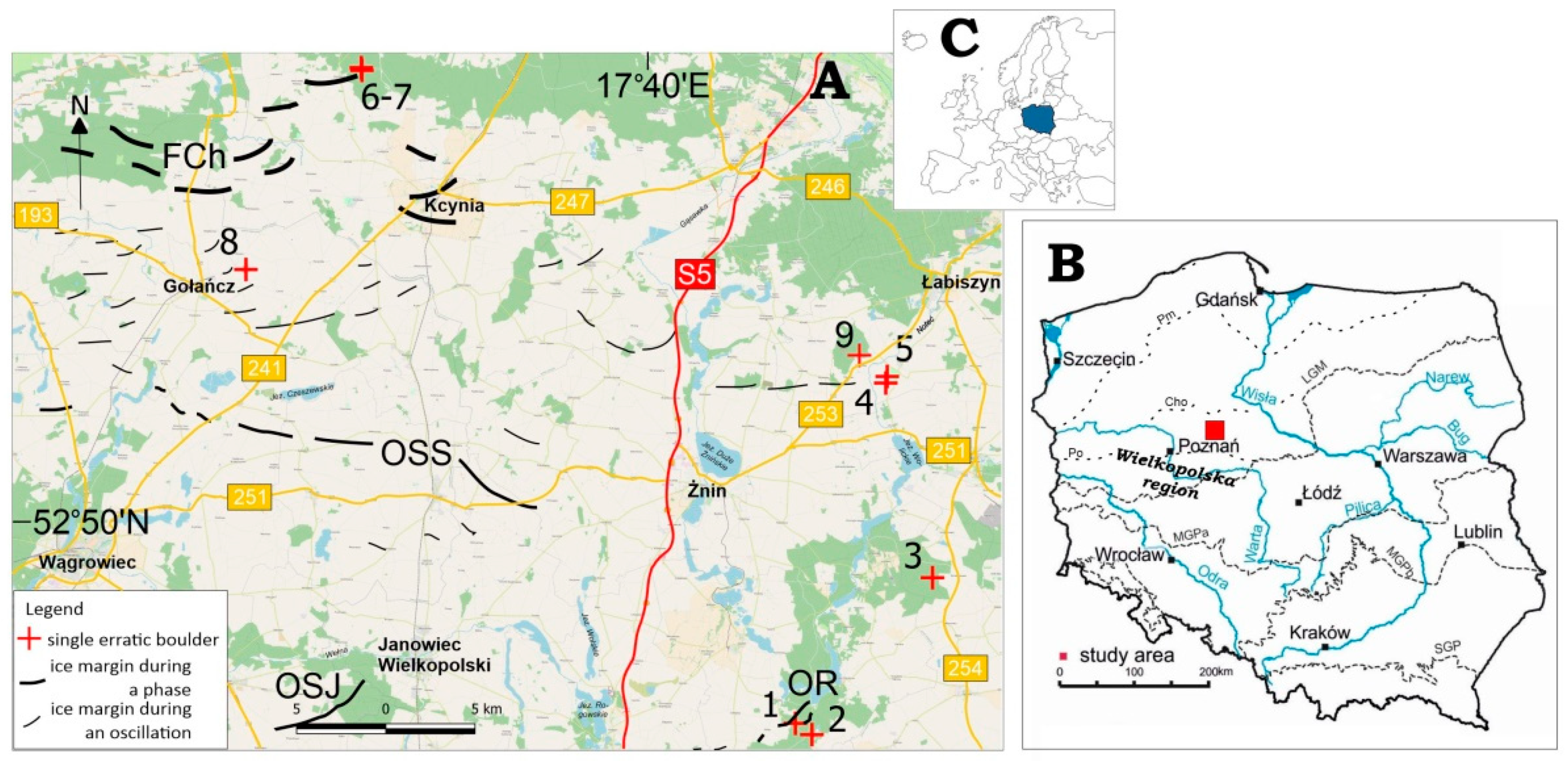
2. Research Area
3. Objectives
4. Methods
5. Review of Erratic Boulders in Pałuki
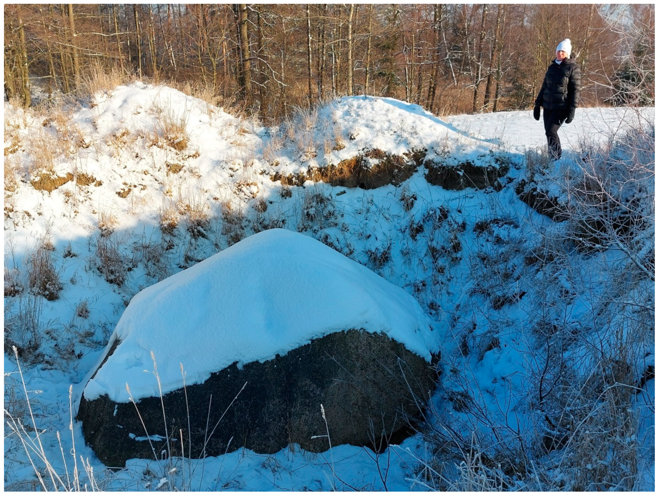
5.1. Boulder by Oćwieka Forester’s House
5.2. Boulder by a Fishing Farm in Bełki
5.3. Stone House (Kamienny Dom) near Szczepankowo
5.4. Boulder in Lubostroń, Close to a Former Forester’s House
5.5. God’s Passion (Boża Męka) or Big Boulder in Lubostroń
5.6. Boulder in Dębogóra Forest Subdistrict
5.7. Big Boulder in Gromadno
5.8. Boulder in Borek Oleski
5.9. Boulder in a forest buffer zone by Załachowo
6. Discussion
7. Conclusions
Funding
Institutional Review Board Statement
Informed Consent Statement
Data Availability Statement
Acknowledgments
Conflicts of Interest
References
- Crofts, R.; Gordon, J.E.; Brilha, J.; Gray, M.; Gunn, J.; Larwood, J.; Santucci, V.; Tormey, D.; Worboys, G.L. Guidelines for Geoconservation in Protected and Conserved Areas. In Best Practice Protected Area Guidelines Series; Series no. 31; IUCN: Gland, Switzerland, 2020. [Google Scholar] [CrossRef]
- Urban, J.; Migoń, P.; Radwanek-Bąk, B. Dziedzictwo Geologiczne. Przegląd Geol. 2021, 69, 16–20. [Google Scholar] [CrossRef]
- Górska-Zabielska, M. Najcenniejsze Głazy Narzutowe w Wielkopolsce i Ich Potencjał Geoturystyczny. Przegląd Geol. 2015, 63, 455–463. [Google Scholar]
- Górska-Zabielska, M. Nowe Obiekty Geoturystyczne Na Południowym Podlasiu. Przegląd Geol. 2020, 68, 91–99. Available online: https://www.pgi.gov.pl/dokumenty-pig-pib-all/publikacje-2/przeglad-geologiczny/2020/2-luty/7591-nowe-obiekty-geoturystyczne-na-poludniowym-podlasiu/file.html (accessed on 16 April 2022).
- Górska-Zabielska, M. The Rock Garden of the Institute of Geography and Environmental Sciences, Jan Kochanowski University—A New Geo-Site in Kielce, Central Poland. Geosciences 2021, 11, 113. [Google Scholar] [CrossRef]
- Górska-Zabielska, M.; Wieczorek, D.; Zabielski, R.; Stoiński, A. Głazy Narzutowe z Regionu Przedborza Jako Obiekty Geodziedzictwa Oraz Ich Znaczenie Dla Geologii Czwartorzędu i Geoturystyki. Przegląd Geol. 2022, 70, 34–49. [Google Scholar] [CrossRef]
- Rinterknecht, V.R.; Marks, L.; Piotrowski, J.A.; Raisbeck, G.M.; Yiou, F.; Brook, E.J.; Clark, P.U. Cosmogenic 10 Be Ages on the Pomeranian Moraine, Poland. Boreas 2005, 34, 186–191. [Google Scholar] [CrossRef]
- Rinterknecht, V.; Braucher, R.; Böse, M.; Bourlès, D.; Mercier, J.-L. Late Quaternary Ice Sheet Extents in Northeastern Germany Inferred from Surface Exposure Dating. Quat. Sci. Rev. 2012, 44, 89–95. [Google Scholar] [CrossRef]
- Ivy-Ochs, S.; Kober, F. Surface Exposure Dating with Cosmogenic Nuclides. Eiszeitalt. Und Ggw. 2008, 57, 179–209. [Google Scholar] [CrossRef] [Green Version]
- Tylmann, K.; Woźniak, P.P.; Rinterknecht, V.R. Erratics Selection for Cosmogenic Nuclide Exposure Dating—An Optimization Approach. Baltica 2018, 31, 100–114. [Google Scholar] [CrossRef]
- Tylmann, K.; Rinterknecht, V.R.; Woźniak, P.P.; Bourlès, D.; Schimmelpfennig, I.; Guillou, V.; ASTER Team. The Local Last Glacial Maximum of the Southern Scandinavian Ice Sheet Front: Cosmogenic Nuclide Dating of Erratics in Northern Poland. Quat. Sci. Rev. 2019, 219, 36–46. [Google Scholar] [CrossRef]
- Kirillova, K.; Fu, X.; Lehto, X.; Cai, L. What Makes a Destination Beautiful? Dimensions of Tourist Aesthetic Judgment. Tour. Manag. 2014, 42, 282–293. [Google Scholar] [CrossRef]
- Kirillova, K.; Lehto, X. Destination Aesthetics and Aesthetic Distance in Tourism Experience. J. Travel Tour. Mark. 2015, 32, 1051–1068. [Google Scholar] [CrossRef]
- Ruban, D.A.; Sallam, E.S.; Ermolaev, V.A.; Yashalova, N.N. Aesthetic Value of Colluvial Blocks in Geosite-Based Tourist Destinations: Evidence from SW Russia. Geosciences 2020, 10, 51. [Google Scholar] [CrossRef] [Green Version]
- Górska-Zabielska, M. Głazy Narzutowe w Wielkopolsce. In Prace i Studia z Geografii i Geologii 18; Bogucki Wydawnictwo Naukowe: Poznań, Poland, 2010. [Google Scholar]
- Zaręba, D. Zielone Szlaki—Greenways. Praktyczny Przewodnik; Biblioteka Partnerstwa: Kraków, Poland, 2007. [Google Scholar]
- Heliak, M. Zielone Szlaki Greenways Jako Produkt Turystyczny. Ekon. Probl. Usług 2010, 52, 475–483. [Google Scholar]
- Wolniewicz, P. Beyond Geodiversity Sites: Exploring the Educational Potential of Widespread Geological Features (Rocks, Minerals and Fossils). Geoheritage 2021, 13, 34. [Google Scholar] [CrossRef]
- Górska-Zabielska, M. Głazy Narzutowe z Obszaru Wycieczek Terenowych 25SPP i Jego Otuliny. In Plejstocen Gór Świętokrzyskich; Ludwikowska-Kędzia, M., Wiatrak, M., Eds.; XXV Konferencja Stratygrafia Plejstocenu Polski; 3-7.09.2018; Huta Szklana k/Bielin: Huta Szklana, Poland, 2018; pp. 190–195. [Google Scholar]
- Kubalíková, L.; Bajer, A.; Balková, M. Brief Notes on Geodiversity and Geoheritage Perception by Lay Public. Geosciences 2021, 11, 54. [Google Scholar] [CrossRef]
- Meyer, K.-D. Der Findlingsgärten in Niedersachsen. Arch. Für Geschiebekd. 2006, 5, 323–338. [Google Scholar]
- Keiter, M. Die “Großen Sieben” Und Der Neue Findlingsgarten in Bielefeld—Botschafter Vom Saalezeitlichen Eisrand. Geschiebekd. Aktuell 2017, 33, 119–129. [Google Scholar]
- Hose, T.A. Geotourism and Interpretation. In Geotourism; Dowling, R.K., Newsome, D., Eds.; Elsevier Butterworth-Heinemann: Oxford, UK, 2005; pp. 221–241. [Google Scholar]
- Hose, T.A. 3G’s for Modern Geotourism. Geoheritage 2012, 4, 7–24. [Google Scholar] [CrossRef]
- Dowling, R.K.; Newsome, D. Geotourism’s Issues and Challenges. In Geotourism; Dowling, R.K., Newsome, D., Eds.; Elsevier Butterworth-Heinemann: Oxford, UK, 2005; pp. 242–254. [Google Scholar]
- Górska-Zabielska, M.; Dobracki, R. Petrographic Garden in Moryń—A New Geotouristic Attraction in Western Poland. Landf. Anal. 2015, 29, 73–80. [Google Scholar] [CrossRef]
- Górska-Zabielska, M.; Zabielski, R. Geotourism Development in an Urban Area Based on the Local Geological Heritage (Pruszków, Central Mazovia, Poland). In Urban Geomorphology. Landforms and Processes in Cities; Thornbush, M.J., Casey, D.A., Eds.; Elsevier: Amsterdam, The Netherlands, 2018; pp. 37–54. [Google Scholar] [CrossRef]
- Górska-Zabielska, M.; Witkowska, K.; Pisarska, M.; Musiał, R.; Jońca, B. The Selected Erratic Boulders in the Świętokrzyskie Province (Central Poland) and Their Potential to Promote Geotourism. Geoheritage 2020, 12, 30. [Google Scholar] [CrossRef] [Green Version]
- Górska-Zabielska, M.; Kusztal, P.; Witkowska, K. Wybrane Głazy Narzutowe Północno-Zachodniego Obrzeżenia Gór Świętokrzyskich—Współczesne Znaczenie i Potencjał Geoturystyczny (Wyżyna Przedborska i Kielecka). Przegląd Geol. 2019, 67, 767–774. [Google Scholar] [CrossRef]
- Brilha, J.; Gray, M.; Pereira, D.; Pereira, P. Geodiversity: An Integrative Review as a Contribution to the Sustainable Management of the Whole of Nature. Environ. Sci. Policy 2018, 86, 19–28. [Google Scholar] [CrossRef] [Green Version]
- Bruno, D.E. Geosite, Concept of. In Encyclopedia of Mineral and Energy Policy; Tiess, G., Majumder, T., Cameron, P., Eds.; Springer: Berlin/Heidelberg, Germany, 2014. [Google Scholar] [CrossRef]
- Gray, M. Geodiversity: Valuing and Conserving Abiotic Nature; Wiley Blackwell: Chichester, UK, 2013. [Google Scholar]
- Central Register of Polish Geosites. Available online: https://cbdgportal.pgi.gov.pl/geostanowiska/ (accessed on 8 April 2022).
- Central Register of Nature Conservation Forms. Available online: https://crfop.gdos.gov.pl/CRFOP/index.jsf (accessed on 8 April 2022).
- Zwoliński, Z. Geodiversity. In Encyclopedia of Geomorphology; Routledge: London, UK, 2004. [Google Scholar]
- Serrano, E.; Ruiz-Flaño, P. Geodiversity. A Theoretical and Applied Concept. Geogr. Helv. 2007, 62, 140–147. [Google Scholar] [CrossRef]
- Gray, M. Geodiversity: Valuing and Conserving Abiotic Nature; John Wiley and Sons: Chichester, UK, 2004. [Google Scholar]
- Gray, M. Geodiversity and Geoconservation: What, Why, and How? In Geodiversity and Geoconservation; Santucci, V.L., Ed.; George Wright Society: Hancock, MI, USA, 2005; Volume 22, pp. 4–11. [Google Scholar]
- Gray, M. Geodiversity: The Backbone of Geoheritage and Geoconservation. In Geoheritage: Assessment, Protection, and Management; Reynard, E., Brilha, J., Eds.; Elsevier: Amsterdam, The Netherlands, 2018; pp. 13–25. [Google Scholar]
- Coratza, P.; Reynard, E.; Zwoliński, Z. Geodiversity and Geoheritage: Crossing Disciplines and Approaches. Geoheritage 2018, 10, 525–526. [Google Scholar] [CrossRef] [Green Version]
- Reynard, E.; Brilha, J. Geoheritage: A Multidisciplinary and Applied Research Topic. In Geoheritage: Assessment, Protection, and Management; Elsevier: Amsterdam, The Netherlands, 2018; pp. 433–438. [Google Scholar]
- Zwoliński, Z.; Najwer, A.; Giardino, M. Methods for Assessing Geodiversity. In Geoheritage: Assessment, Protection, and Management; Reynard, E., Brilha, J., Eds.; Elsevier: Amsterdam, The Netherlands, 2018; pp. 27–52. [Google Scholar]
- Santangelo, N.; Valenta, E. Geoheritage and Geotourism Resources. Resources 2020, 9, 80. [Google Scholar] [CrossRef]
- Crofts, R.; Tormey, D.; Gordon, J.E. Introducing New Guidelines on Geoheritage Conservation in Protected and Conserved Areas. Geoheritage 2021, 13, 33. [Google Scholar] [CrossRef]
- Pasquaré, M.F.; Bonali, F.L. Virtual Geosites as Innovative Tools for Geoheritage Popularization: A Case Study from Eastern Iceland. Geosciences 2021, 11, 149. [Google Scholar] [CrossRef]
- Woźniak, P.P.; Tylmann, K.; Kobiela, A. Głazy Narzutowe Trójmiejskiego Parku Krajobrazowego—Potencjał Badawczy i Geoturystyczny. Przegląd Geol. 2015, 63, 256–262. [Google Scholar]
- Płotkowski, L. Ekonomiczne Aspekty Oceny Funkcji Lasu, Czyli Gospodarka Leśna w Koncepcji Zrównoważonego Rozwoju. Studia I Mater. Cent. Edukac. Przyr. -Leśnej 2008, 10, 252–272. [Google Scholar]
- Janeczko, E. Społeczne Uwarunkowania Rekreacji w Lasach Na Przykładzie Mazowieckiego Parku Krajobrazowego (MPK). Turystyka i Rekreacja 2005, 1, 25–28. [Google Scholar]
- Janeczko, E.; Woznicka, M.; Tomusiak, R.; Dawidziuk, A.; Kargul-Plewa, D.; Janeczko, K. Preferencje Społeczne Dotyczące Rekreacji w Lasach Mazowieckiego Parku Krajobrazowego w Roku 2000 i 2012. Sylwan 2017, 161, 422–429. [Google Scholar]
- Gössling, S.; Hickler, T. Tourism and Forest Ecosystems. In Tourism and Global Environmental Change: Ecological, Economic, Social and Political Interrelationships; Gössling, S., Hall, M.C., Eds.; Routledge: London, UK, 2005; pp. 95–106. [Google Scholar] [CrossRef]
- Bonilla-Duarte, S.; Gómez-Valenzuela, V.; Vargas-de la Mora, A.-L.; García-García, A. Urban Forest Sustainability in Residential Areas in the City of Santo Domingo. Forests 2021, 12, 884. [Google Scholar] [CrossRef]
- Hornsten, L. Outdoor Recreation in Swedish Forests—Implications for Society and Forestry. Acta Univ. Agric. Suec. Silvestria 2000, 169, 1–29. [Google Scholar]
- Lindhagen, A.; Hörnsten, L. Forest Recreation in 1977 and 1997 in Sweden: Changes in Public Preferences and Ehavior. Forestry 2000, 73, 143–153. [Google Scholar] [CrossRef]
- Ahtikoski, A.; Tuulentie, S.; Hallikainen, V.; Nivala, V.; Vatanen, E.; Tyrväinen, L.; Salminen, H. Potential Trade-Offs between Nature-Based Tourism and Forestry, a Case Study in Northern Finland. Forests 2011, 2, 894–912. [Google Scholar] [CrossRef] [Green Version]
- Janeczko, E.; Janeczko, K. Las Jako Produkt Turystyczny Na Przykładzie Leśnego Kompleksu Promocyjnego (LKP) Puszcza Białowieska. Turystyka i Rekreacja 2005, 1, 57–70. [Google Scholar]
- Kikulski, J. Turystyczno−rekreacyjne Funkcje Lasów w Polsce—Społeczne Obawy i Nadzieje (Wyniki Pierwszej Części Badań). Sylwan 2008, 6, 63–71. [Google Scholar]
- Kikulski, J. Model Rekreacyjnego Zagospodarowania Lasów Na Terenach Pojezierzy. Studia i Materiały Centrum Edukacji Przyrodniczo-Leśnej 2009, 11, 165–171. [Google Scholar]
- Hulewicz, M.A.; Rutkiewicz, A. Leśny Produkt Turystyczny “Leczenie Lasem”—Analiza Przypadku. Studia i Materiały Centrum Edukacji Przyrodniczo-Leśnej 2017, 19, 205–214. Available online: https://cepl.sggw.edu.pl/wp-content/uploads/sites/75/2021/08/Rutkiewicz_Hulewicz.pdf (accessed on 15 April 2022).
- Gołos, P. Społeczne i Ekonomiczne Aspekty Pozaprodukcyjnych Funkcji Lasu i Gospodarki Leśnej—Wyniki Badań Opinii Społecznej. In Prace Instytutu Badawczego Leśnictwa. Rozprawy i Monografie 22; Skocin Stary: Gmina Raszyn, Poland, 2018. [Google Scholar]
- Wierzbicka, A. Zrównoważony Rozwój w Edukacji Leśnej—Jak? Przykłady Dobrych Praktyk. Studia i Materiały Centrum Edukacji Przyrodniczo-Leśnej 2018, 20, 137–143. [Google Scholar]
- Szymańska, E.; Kalejta, J. Wellness Tourism and Non-Productive Function of Forests/Turystyka Uzdrowiskowa a Pozaprodukcyjna Funkcja Lasów. Econ. Reg. Stud. 2018, 11, 96–105. [Google Scholar] [CrossRef] [Green Version]
- Zawadzka, A.; Bielinis, E. Możliwości Wykorzystania Terenów Leśnych Do Terapii Lasem—Czy Dzięki Drzewom Możemy Stać Się Szczęśliwsi i Zdrowsi? Studia i Materiały CEPL w Rogowie 2019, 21, 85–88. [Google Scholar]
- Kowal, P.; Brytan, R.; Wojtyszyn, S.; Jackowiak, M.; Dawidziuk, A. “Leśna Odskocznia”—Czy Mieszkańcy Miast Lubią Dokształcać Się w Lesie? Studia I Mater. Cent. Edukac. Przyr.-Leśnej 2019, 21, 59–67. [Google Scholar]
- Kang, N.; Wang, E.; Yu, Y.; Duan, Z. Valuing Recreational Services of the National Forest Parks Using a Tourist Satisfaction Method. Forests 2021, 12, 1688. [Google Scholar] [CrossRef]
- Kieszek, A.; Kikulski, J. Przystosowanie Żwirowisk w Lasach Dla Potrzeb Rekreacji i Turystyki Jako Sposób Na Ochronę Środowiska Leśnego Przed Presją Ruchu Turystyczno-Turystycznego. In Problemy Zrównoważonego Rozwoju Turystyki, Rekreacji i Sportu w Lasach; Pieńkos, K., Ed.; Wyd. Akademii Wychowania Fizycznego: Warszawa, Poland, 2004; pp. 380–386. [Google Scholar]
- Szczęch, M.; Cieszkowski, M.; Chodyń, R.; Loch, J. Geotouristic Values of the Gorce National Park and Its Surroundings (The Outer Carpathians, Poland). Geotourism 2016, 1–2, 27–44. [Google Scholar] [CrossRef]
- Kasprowska-Nowak, K.; Marek, A. Geotourism Valorisation of Selected Quarries of Kłodzko Region and Cieszyn Foothills. Quaest. Geogr. 2019, 38, 41–51. [Google Scholar] [CrossRef] [Green Version]
- Chen, Z.; Fu, W.; Bosch, C.C.K.V.D.; Pan, H.; Huang, S.; Zhu, Z.; Qiao, Y.; Wang, N.; Dong, J. National Forest Parks in China: Origin, Evolution, and Sustainable Development. Forests 2019, 10, 323. [Google Scholar] [CrossRef] [Green Version]
- Chrobak, A.; Novotný, J.; Struś, P. Geodiversity Assessment as a First Step in Designating Areas of Geotourism Potential. Case Study: Western Carpathians. Front. Earth Sci. 2021, 9, 752669. [Google Scholar] [CrossRef]
- Polish State Forests. Available online: https://www.lasy.gov.pl/pl/turystyka (accessed on 15 February 2022).
- Time for Forest. Available online: https://czaswlas.pl/mapa (accessed on 15 February 2022).
- Solon, J.; Borzyszkowski, J.; Bidłasik, M.; Richling, A.; Badora, K.; Balon, J.; Brzezińska-Wójcik, T.; Chabudziński, Ł.; Dobrowolski, R.; Grzegorczyk, I.; et al. Physico-Geographical Mesoregions of Poland: Verification and Adjustment of Boundaries on the Basis of Contemporary Spatial Data. Geogr. Pol. 2018, 91, 143–170. [Google Scholar] [CrossRef]
- Pospieszny, Ł.; Sobkowiak-Tabaka, I.; Nowaczyk, S. Megalityczny Grobowiec Kultury Amfor Kulistych z Kierzkowa Na Pałukach. Milczący Świadek Kultu Przodków w Epoce Kamienia; Wydawnictwo Biskupin: Biskupin, Poland, 2017. [Google Scholar]
- Kozarski, S. Recesja Ostatniego Lądolodu z Północnej Części Wysoczyzny Gnieźnieńskiej a Kształtowanie Się Pradoliny Noteci-Warty., Prace Komisji Geograficzno-Geologicznej Poznańskiego Towarzystwa Przyjaciół Nauk; Wydział Matematyczno-Przyrodniczy: Warszawa, Poland, 1962. [Google Scholar]
- Marks, L. Quaternary Glaciations in Poland. In Quaternary Glaciations—Extent and Chronology, a Closer Look; Ehlers, J., Gibbard, P.L., Hughes, P.D., Eds.; Developments in Quaternary Science; Elsevier: Amsterdam, The Netherlands, 2011; Volume 15, pp. 299–303. [Google Scholar]
- Wachecka-Kotkowska, L. Rozwój Rzeźby Obszaru Między Piotrkowem Trybunalskim, Radomskiem a Przedborzem w Czwartorzędzie (in Polish with English Summary); Wyd. UŁ: Łódź, Poland, 2015. [Google Scholar]
- Marks, L. Timing of the Late Vistulian (Weichselian) Glacial Phases in Poland. Quat. Sci. Rev. 2012, 44, 81–88. [Google Scholar] [CrossRef]
- Kozarski, S. Deglacjacja Północno-Zachodniej Polski: Warunki Środowiska i Transformacja Geosystemu (~20 Ka → 10 Ka BP); Dokumentacja Geograficzna 1; Continuo: London, UK, 1995. [Google Scholar]
- Sydow, S.; Machowiak, W. Objaśnienia Do Szczegółowej Mapy Geologicznej Polski w Skali 1:50 000. Arkusz Rogowo (397); Państwowy Instytut Geologiczny-Państwowy Instytut Badawczy: Warszawa, Poland, 2004. [Google Scholar]
- Nature Conservation Act. 2004. Available online: https://crfop.gdos.gov.pl/CRFOP/index.jsf (accessed on 10 April 2022).
- Gałuszka, N.; Kazior, B.; Zaręba, D. Turystyka Dziedzictwa. Poradnik Dla Organizacji Pozarządowych; Biblioteka Partnerstwa: Kraków, Poland, 2008; Available online: https://www.academia.edu/33891377/Turystyka_dziedzictwa?auto=download&email_work_card=download-paper (accessed on 15 April 2022).
- Płoskonka, P. Edukacja Na Rzecz Odpowiedzialnej Turystyki Na Terenach Przyrodniczo Cennych—Idea Leave No Trace. Studia I Mater. Cent. Edukac. Przyr.-Leśnej 2018, 20, 93–102. [Google Scholar]
- Szyda, B.; Karasiewicz, T. Znaczenie Obszarów Przyrodniczo Cennych w Rozwoju Funkcji Turystycznej Stref Podmiejskich Wybranych Polskich Miast. Studia I Mater. Cent. Edukac. Przyr. -Leśnej 2017, 19, 174–181. Available online: https://cepl.sggw.edu.pl/wp-content/uploads/sites/75/2021/08/Szyda_Karasiewicz.pdf (accessed on 15 April 2022).
- Paschalis, P. Nauka i Badania Leśne u Progu XXI Wieku. Sylwan 1997, 2, 5–10. [Google Scholar]
- Paschalis, P. Forest Utilization in Sustainable Multifunctional Forestry; Wydawnictwo SGGW: Warszawa, Poland, 2002. [Google Scholar]
- Górska, M. Fennoscandian Erratics in Glacial Deposits of the Polish Lowland—Methodical Aspects. Studia Quat. 2006, 23, 11–15. [Google Scholar]
- Meyer, K.-D.; Lüttig, G. Was Meinen Wir Mit Leitgeschiebe? Geschiebekd. Aktuell 2007, 23, 106–121. [Google Scholar]
- Schulz, W. Sedimentäre Findlinge Im Norddeutschen Vereisungsgebiet. Arch. Für Geschiebekd. 1999, 2, 523–560. [Google Scholar]
- Lüttig, G. Methodische Fragen Der Geschiebeforschung. Geol. Jahrb. 1958, 75, 361–418. [Google Scholar]
- Hesemann, J. Kristalline Geschiebe Der Nordischen Vereisungen; Geologisches Landesamt Nordrhein-Westphalen: Krefeld, Germany, 1975; pp. 1–267. [Google Scholar]
- Pałac w Lubostroniu. Available online: https://zabytek.pl/pl/obiekty/lubostron-palac-w-zespole-palacowo-parkowym (accessed on 9 April 2022).
- Urban, J. Protection of Inanimate Nature Objects in the Góry Œwiêtokrzyskie (Holy Cross Mts) Province. Rocz. Świętokrzyski 1990, 17, 47–79. [Google Scholar]
- Urban, J. Geologia i Rzeźba Obszaru Badań. In Waloryzacja Przyrodnicza Szanieckiego Parku Krajobrazowego; Zając, T., Ed.; Archiwum Instytutu Ochrony Przyrody Polskiej Akademii Nauk: Kraków, Poland, 1997. [Google Scholar]
- Stoiński, A. Głazy Narzutowe w Okolicy Radoszyc. Master’s Thesis, Uniwersytet Jana Kochanowskiego w Kielcach, Kielce, Poland, 1997. Archiwum Instytutu Geografii. [Google Scholar]
- Pernal, J. Pomniki Przyrody Woj. Świętokrzyskiego. Głazy Narzutowe. Część I; Liga Ochrony Przyrody: Kielcem, Poland, 2004; 2 vols. [Google Scholar]
- Pernal, J. Pomniki Przyrody Woj. Świętokrzyskiego. Głazy Narzutowe. Część II; Liga Ochrony Przyrody: Kielcem, Poland, 2005; 2 vols. [Google Scholar]
- Kusztal, P. Budowa Geologiczna i Rzeźba Doliny Czarnej Koneckiej Pomiędzy Janowem a Wąsoszem Starą Wsią. Master’s Thesis, Uniwersytet Jana Kochanowskiego w Kielcach, Kielce, Poland, 2016. Archiwum Instytutu Geografii. [Google Scholar]
- Reynard, E. Protecting Stones: Conservation of Erratic Blocks in Switzerland. In Dimension Stone. New Perspectives for a Traditional Building Material; Pikryl, R., Ed.; Balkema: Leiden, The Netherlands, 2004; pp. 3–7. [Google Scholar]
- Migoń, P. Geoturystyka; Wydawnictwo Naukowe PWN: Warszawa, Poland, 2012. [Google Scholar]
- Brilha, J. Inventory and Quantitative Assessment of Geosites and Geodiversity Sites: A Review. Geoheritage 2016, 8, 119–134. [Google Scholar] [CrossRef] [Green Version]
- Raposo, V.B.; Melo, C.S.; Silva, L.; Ventura, A.; Câmara, R.; Pombo, J.; Johnson, M.E.; Ávila, S.P. Comparing Methods of Evaluation of Geosites: The Fossiliferous Outcrops of Santa Maria Island (Azores, NE Atlantic) as a Case Study for Sustainable Island Tourism. Sustainability 2018, 10, 3596. [Google Scholar] [CrossRef] [Green Version]
- Piotrowski, K. Dobry Pomysł Na Biznes. Kamieniarstwo “Głazowe”. Nowy Kamieniarz 2008, 34, 58–62. [Google Scholar]
- Chrząszczewski, W. Stoneman Spod Konina. Nowy Kamieniarz 2009, 43, 40–44. [Google Scholar]
- Górska-Zabielska, M. Ogródek Petrograficzny Wielkopolskiego Parku Narodowego w Jeziorach; Bogucki Wydawnictwo Naukowe: Poznań, Poland, 2008. [Google Scholar]
- Górska-Zabielska, M. Lapidarium Petrograficzne—Stanowisko Złocieniec, Pojezierze Drawskie. In Plejstoceńskie Środowiska Sedymentacyjne Pojezierza Pomorskiego; Pisarska-Jamroży, M., Babiński, Z., Eds.; Wyd. Uniwersytetu Kazimierza Wielkiego: Bydgoszcz, Poland, 2009; pp. 64–70. [Google Scholar]
- Waldron, J.W.F.; Locock, A.J.; Pujadas-Botey, A. Building an Outdoor Classroom for Field Geology: The Geoscience Garden. J. Geosci. Educ. 2016, 64, 215–230. [Google Scholar] [CrossRef]
- Ciupa, T.; Suligowski, R.; Sutowicz-Kwiecińska, M. Ujęcie Siarczkowych Wód Leczniczych i Lapidarium w Uzdrowiskowym Zakładzie Górniczym, “Las Winiarski” Nową Atrakcją Geoturystyczną w Okolicach Buska Zdroju. Studia Mater. Misc. Oeconomicae 2017, 21, 93–105. [Google Scholar]
- Mader, A.; Bąk, E. Walory Edukacyjne Muzeum Geologicznego Przy Oddziale Świętokrzyskim Państwowego Instytutu Geologicznego—PIB w Kielcach. In Popularyzacja Geoturystyki; Geoprodukt. 5 Ogólnopolskie Forum; Geological Museum of the Polish Geological Institute: Zabrze, Poland, 2019; pp. 10–11. [Google Scholar]
- Muszer, J. Georetum w Arboretum w Wojsławicach—Punkt Wycieczkowy Nr 5. In XXIV Konferencja Naukowa Sekcji Paleontologicznej PTG; Wyd. Uniwersytet Wrocławski: Wrocław, Poland, 2019; pp. 119–125. [Google Scholar]
- Moliner, L.; Mampel, L. The Rock Garden “Geologist Juan Paricio” (Alcorisa, Maestrazgo Geopark, Spain): An Effective Example of Geosciences Popularization. Geoheritage 2019, 11, 1869–1878. [Google Scholar] [CrossRef]
- Krzeczyńska, M.; Wierzbowski, A.; Woźniak, P.; Świło, M.; Chećko, A. Działania Muzeum Geologicznego Państwowego Instytutu Geologicznego—Państwowego Instytutu Badawczego Prowadzone w Celu Wykorzystania Edukacyjnego i Ochrony Starych Kamieniołomów. Przegląd Geol. 2020, 68, 187–193. [Google Scholar]
- Elmi, C.; Simal, A.G.; Winchester, G.P. Developing a Rock Garden at Edith J. Carrier Arboretum, Harrisonburg VA (U.S.A.) as a Resource for Promoting Geotourism. Geosciences 2020, 10, 415. [Google Scholar] [CrossRef]
- Cai, G. The Changing Landscape: A Study of Natural Transformation on Ryoan-Ji Rock Garden. Acad. Lett. 2021, 2098. [Google Scholar] [CrossRef]
- Garofano, M. Geowatching, a Term for the Popularisation of Geological Heritage. Geoheritage 2015, 7, 25–32. [Google Scholar] [CrossRef]
- Żbikowski, J. Zagospodarowanie Turystyczne Gminy Łuków; Mizerski, W., Ed.; Na krawędzi platformy. Polskie Towarzystwo Geologiczne: Łuków, Poland, 2018; pp. 51–52. [Google Scholar]
- Jędrek—New Monument of Animate Nature in Garwolin Community. 2018. Available online: https://www.wirtualnygarwolin.pl/aktualnoci/63-aktualnoci/10770-jedrek-nowy-pomnik-przyrody-w-gminie-garwolin (accessed on 10 April 2022).
- Orientation-Oriented Tourist and Recreational Events. Available online: https://trino.pttk.pl/ (accessed on 25 January 2022).
- The Day of a Glacial Erratic. 2013. Available online: https://www.moryn.pl/art,97,dzien-glazu-2013 (accessed on 10 April 2022).


| Boulder’s Name or location | Coordinates | Length [m] | Width [m] | Height [m] | Volume [m3] | Weight [t] | Perimeter [m] | Source Region and Petrographic /Indicator Type | Protection * |
|---|---|---|---|---|---|---|---|---|---|
| 1. Boulder by Oćwieka forester’s house | 17°48′07” E 52°43′43” N | 3.0 | 2.7 | 1.4 | 5.93 | 16.31 | 9.35 | Metamorphic rock | 1985-04-10 |
| 2. Boulder by a fishing farm in Bełki | 17°48′57” E 52°43′23” N | 2.6 | 2.0 | 1.0 | 2.72 | 7.48 | 9.1 | Småland granite | 1985-04-10 |
| 3. Stone House (Kamienny Dom) near Szczepankowo | 17°54′50” E 52°48′12” N | 4.2 | 3.4 | 2.5 | 18.67 | 51.35 | 13.1 | Småland granite | 1955-04-01 |
| 4. Lubostroń, close to a former forester’s house | 17°52′21” E 52°54′05” N | 3.2 | 1.6 | 0.7 | 1.87 | 5.15 | 9.0 | Uppsala granite | 1955-06-01 |
| 5. God’s Passion (Boża Męka) or Big Boulder in Lubostroń | 17°52′25” E 52°54′17” N | 4.2 | 3.5 | 0.8 | 6.15 | 16.91 | 12.0 | - | 1955-06-01 |
| 6. Boulder in Dębogóra Forest Subdistrict | 17°25′50” E 53°03′16” N | 3.6 | 3.6 | 0.35 | 2.37 | 6.52 | 11.5 | Småland granite | 1990-02-10 |
| 7. Big Boulder in Gromadno | 17°25′48” E 53°03′21” N | 4.5 | 3.5 | 1.7 | 14 | 38.51 | 14.9 | Småland granite | 1970-07-31 |
| 8. Boulder in Borek Oleski | 17°20′15” E 52°57′09” N | 5.25 | 3.7 | 1.3 | 13.21 | 36.32 | 14.3 | Blekinge granite | 1957-06-01 |
| 9. Boulder in a forest buffer zone by Załachowo | 17°51′01” E 52°54′52” N | 3.0 | 2.31 | 1.53 | 5.55 | 15.25 | 10.56 | Åland rapakivi granite | - |
Publisher’s Note: MDPI stays neutral with regard to jurisdictional claims in published maps and institutional affiliations. |
© 2022 by the author. Licensee MDPI, Basel, Switzerland. This article is an open access article distributed under the terms and conditions of the Creative Commons Attribution (CC BY) license (https://creativecommons.org/licenses/by/4.0/).
Share and Cite
Górska-Zabielska, M. Geoheritage in a Forest: Traces of Ice Sheets in Pałuki, Western Poland. Sustainability 2022, 14, 7190. https://doi.org/10.3390/su14127190
Górska-Zabielska M. Geoheritage in a Forest: Traces of Ice Sheets in Pałuki, Western Poland. Sustainability. 2022; 14(12):7190. https://doi.org/10.3390/su14127190
Chicago/Turabian StyleGórska-Zabielska, Maria. 2022. "Geoheritage in a Forest: Traces of Ice Sheets in Pałuki, Western Poland" Sustainability 14, no. 12: 7190. https://doi.org/10.3390/su14127190
APA StyleGórska-Zabielska, M. (2022). Geoheritage in a Forest: Traces of Ice Sheets in Pałuki, Western Poland. Sustainability, 14(12), 7190. https://doi.org/10.3390/su14127190