
The Groundwater Flow Behavior and the Recharge in the Nubian Sandstone Aquifer System during the Wet and Arid Periods


Abstract
:1. Introduction
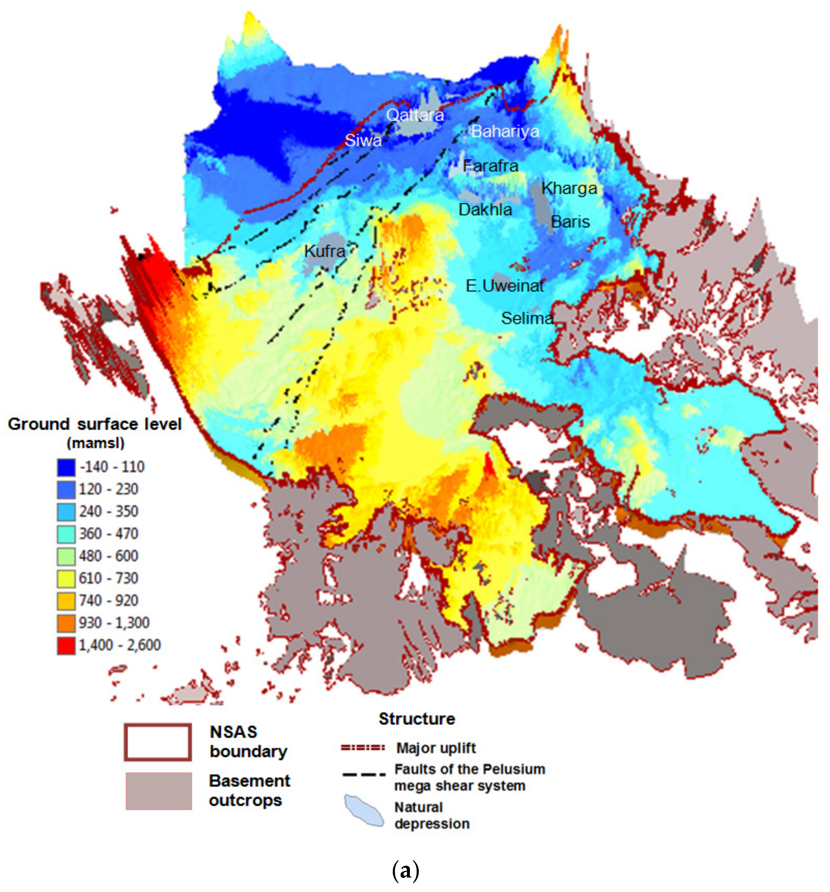
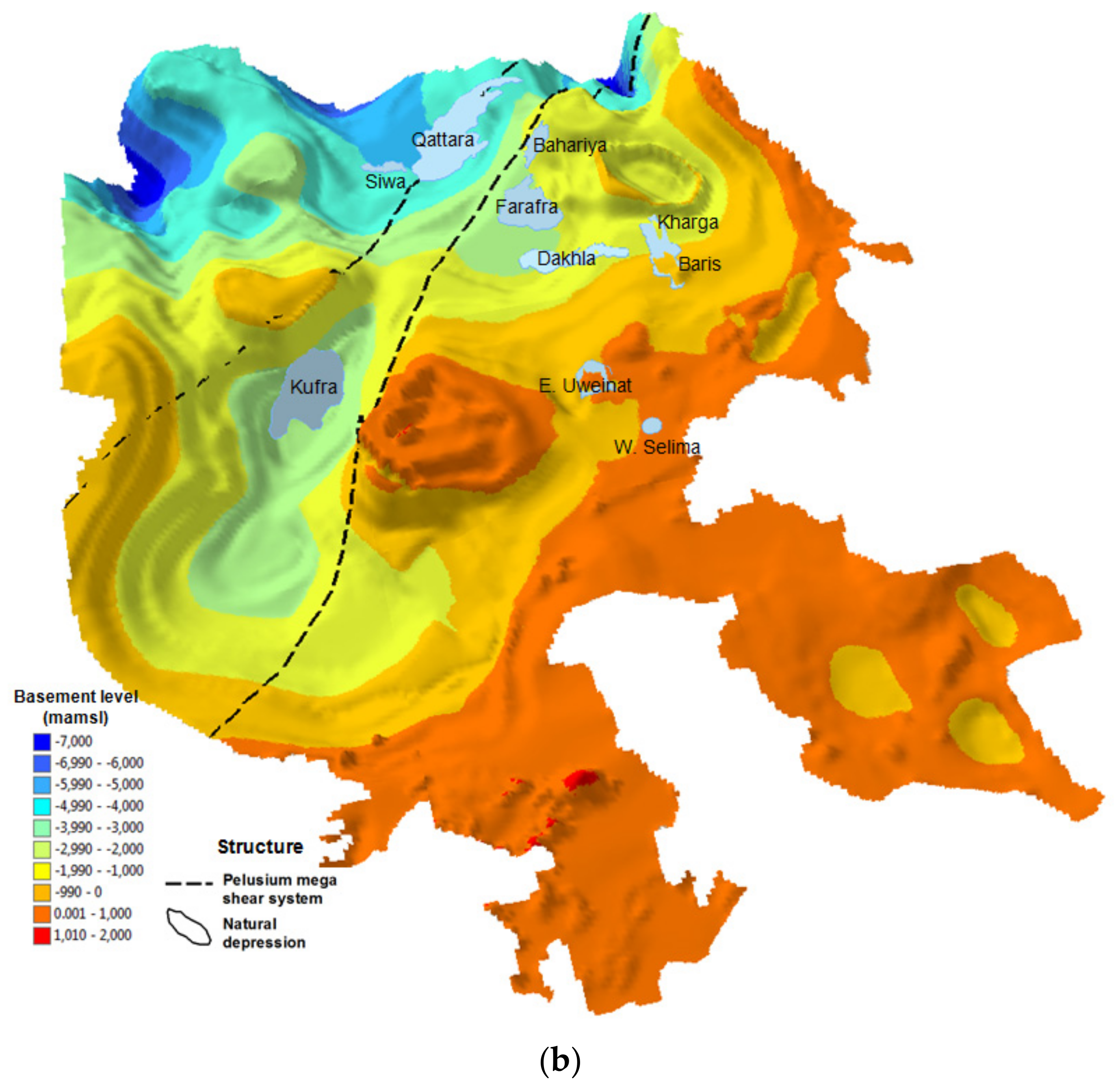
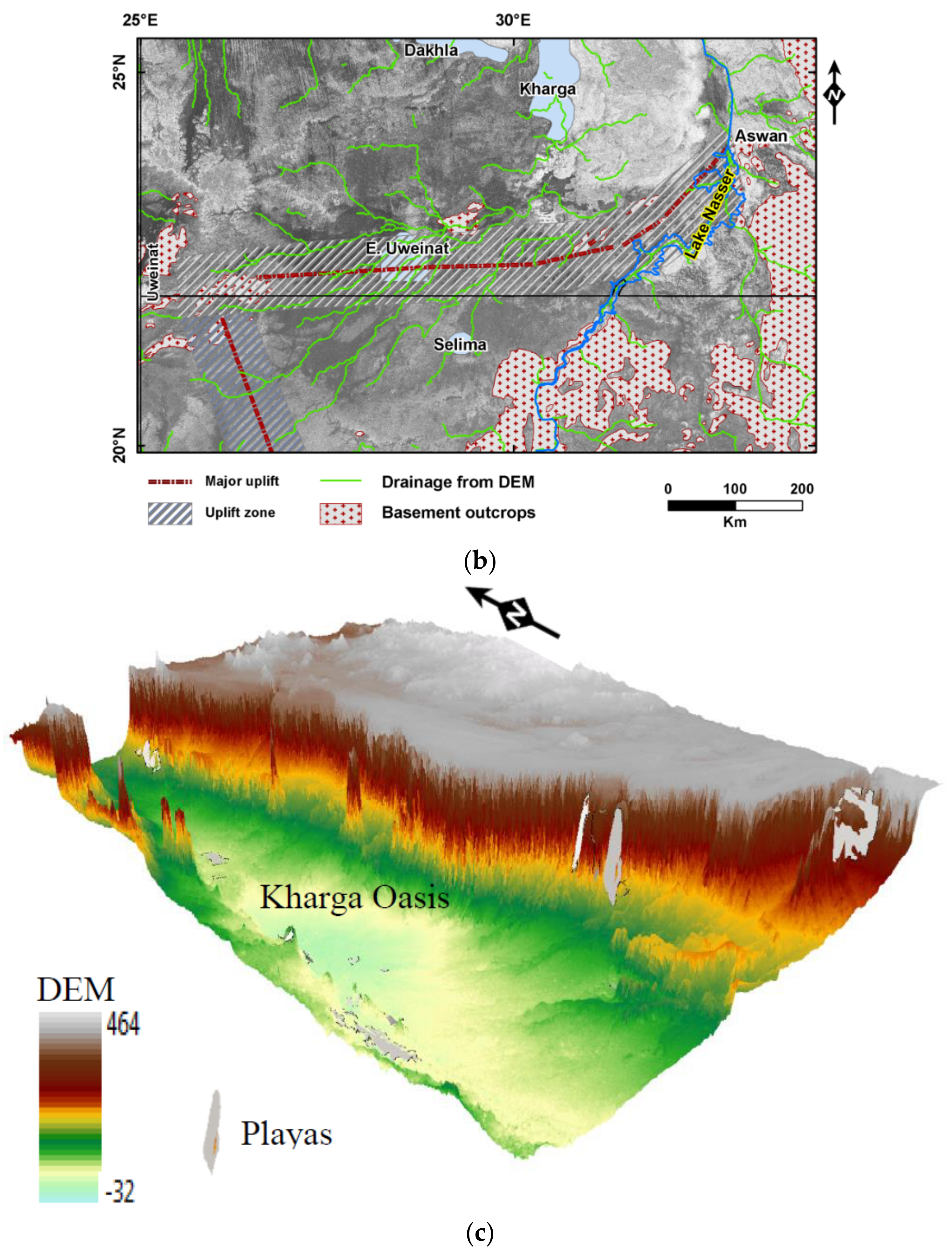
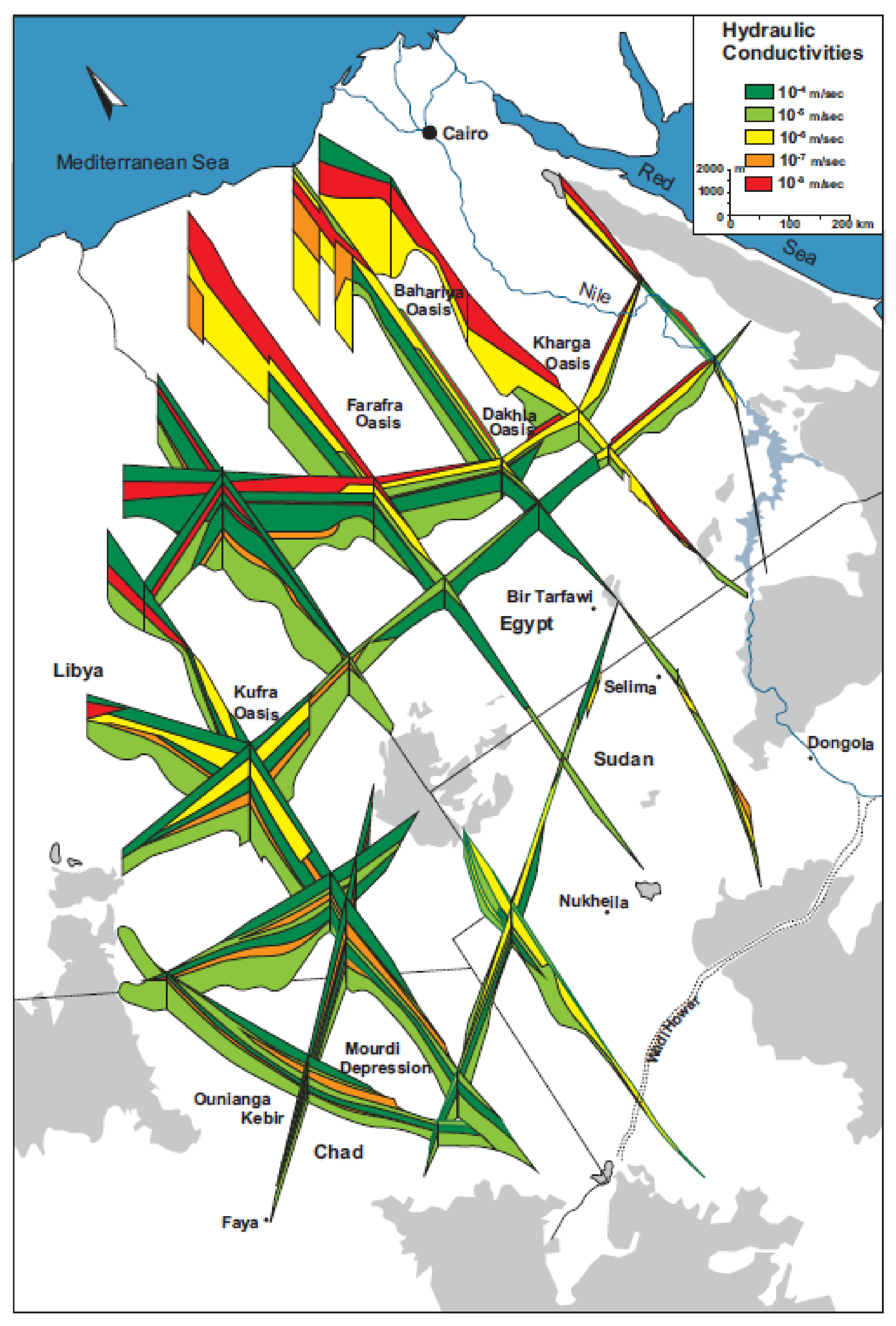
2. Geology
3. Climate
4. Material and Methods
4.1. Model Domain
4.2. Initial and Boundary Conditions
4.3. Model Calibration
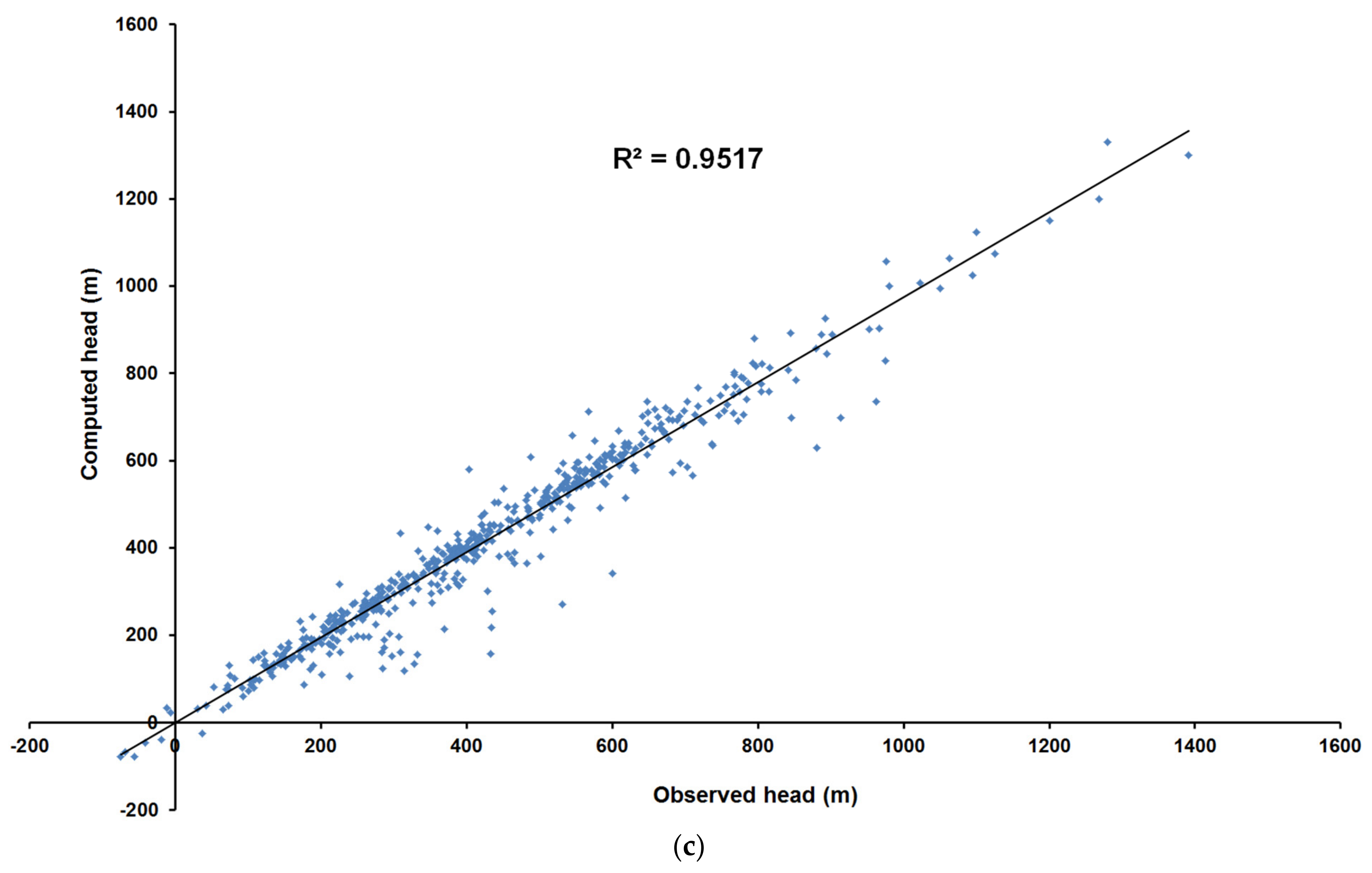
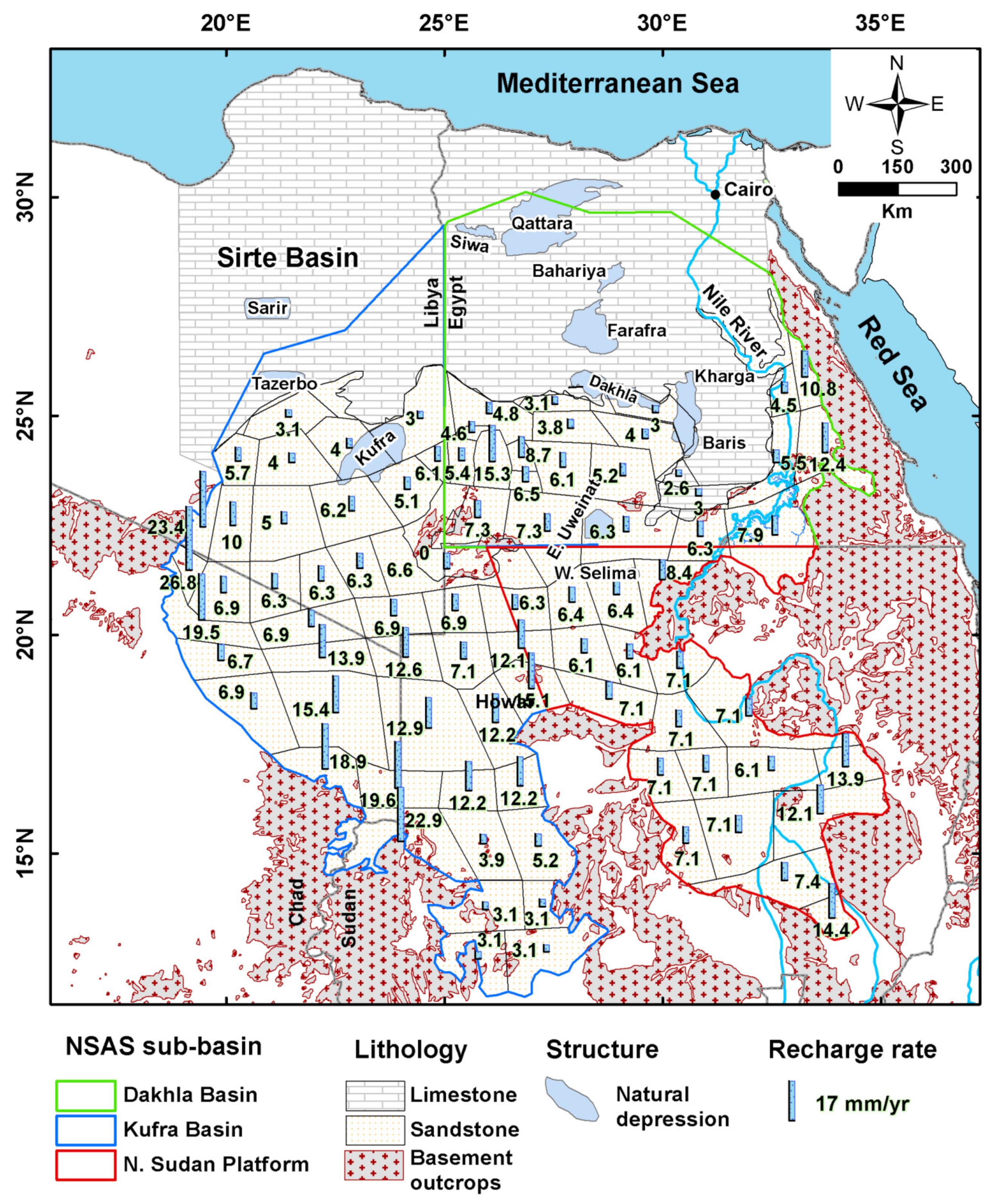
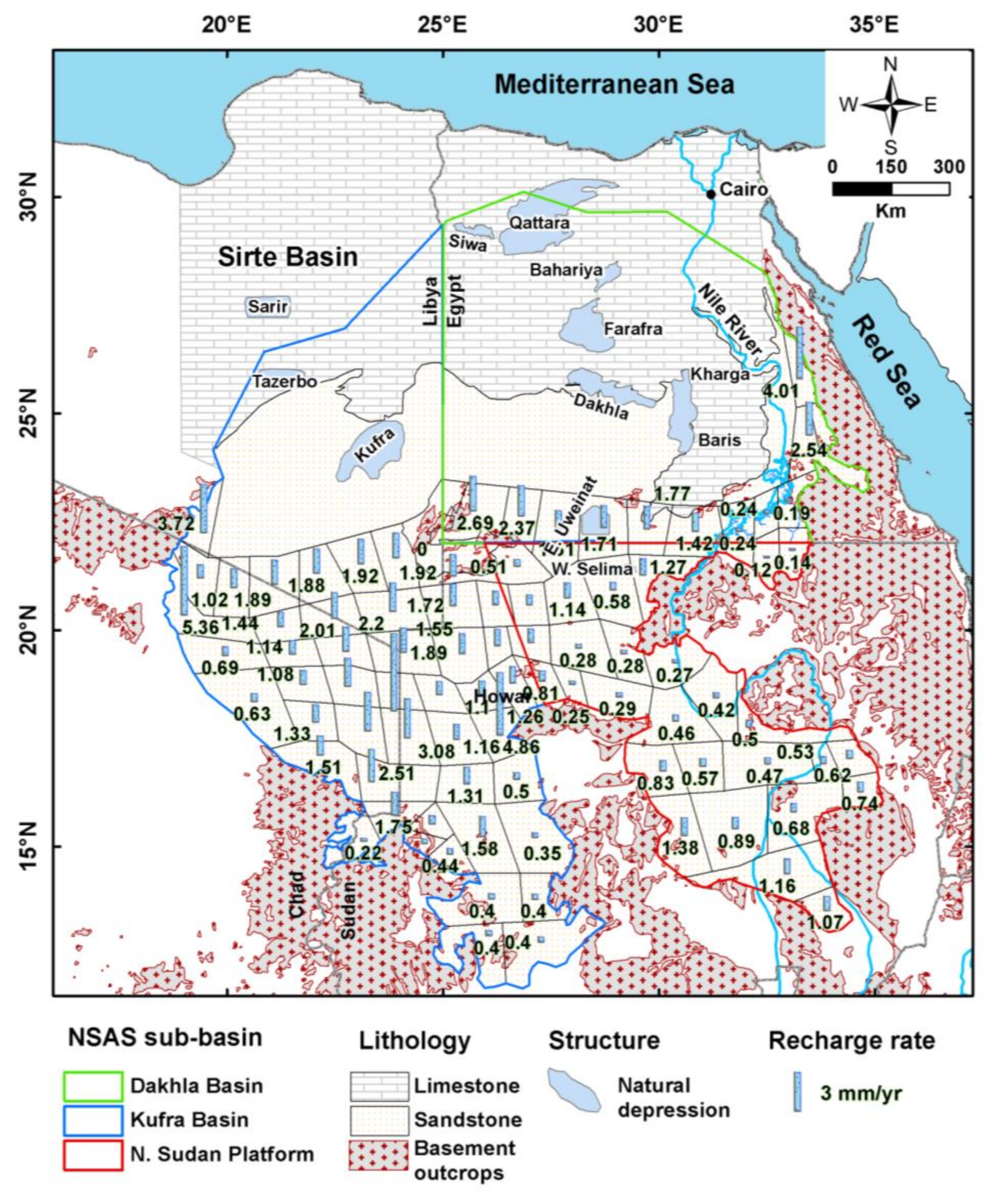
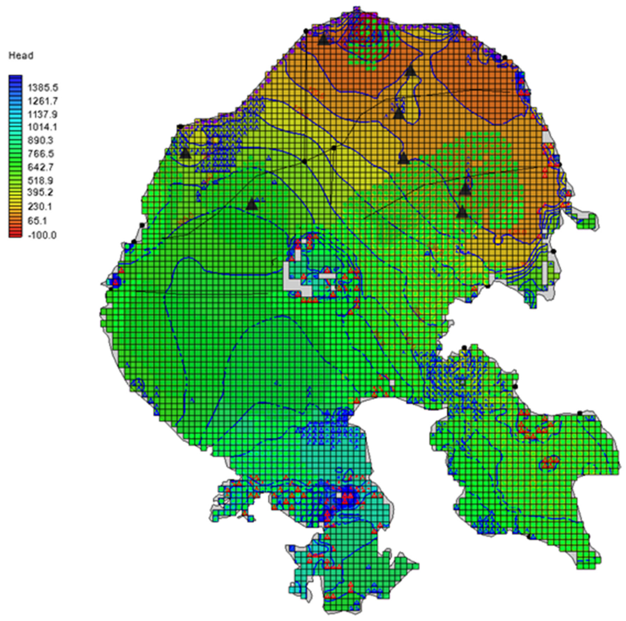
4.3.1. Steady State Filled-Up Stage
4.3.2. Long-Term Transient Stage
4.3.3. Short-Term Transient Stage (1960–2010)
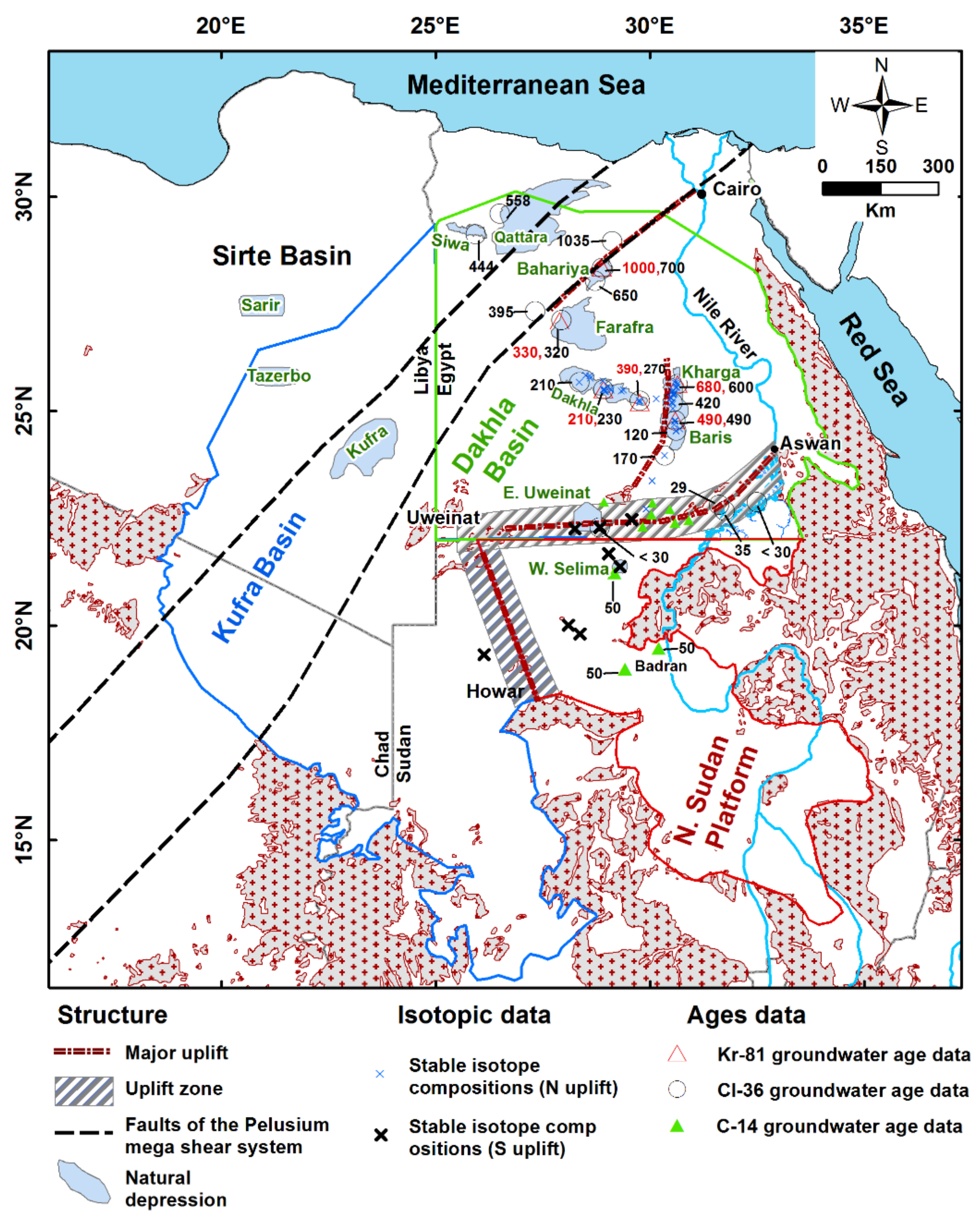
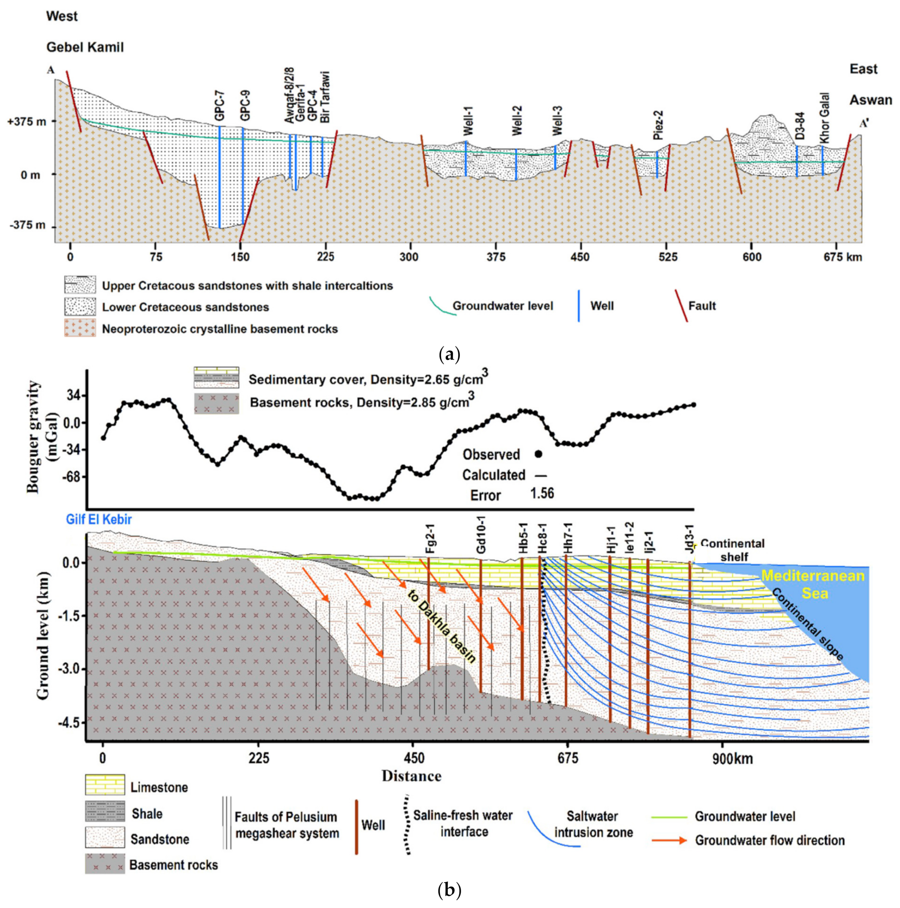
5. Evidence Supporting the Groundwater Flow Paths
6. Conclusions
Author Contributions
Funding
Data Availability Statement
Acknowledgments
Conflicts of Interest
References
- Sarnthein, M.; Tetzlaff, G.; Koopmann, B.; Wolter, K.; Pflaumann, U. Glacial and interglacial wind regimes over the eastern subtropical Atlantic and North-West Africa. Nature 1981, 293, 193–196. [Google Scholar] [CrossRef]
- Prell, W.L.; Kutzbach, J.E. Monsoon variability over the past 150,000 years. J. Geophys. Res. Earth Surf. 1987, 92, 8411–8425. [Google Scholar] [CrossRef]
- Yan, Z.; Petit-Maire, N. The last 140 ka in the Afro-Asian arid/semi-arid transitional zone. Palaeogeogr. Palaeoclim. Palaeoecol. 1994, 110, 217–233. [Google Scholar] [CrossRef]
- Sultan, M.; Sturchio, N.; Hassan, F.; Hamdan, M.A.R.; Mahmood, A.M.; El Alfy, Z.; Stein, T. Precipitation Source Inferred from Stable Isotopic Composition of Pleistocene Groundwater and Carbonate Deposits in the Western Desert of Egypt. Quat. Res. 1997, 48, 29–37. [Google Scholar] [CrossRef]
- Sturchio, N.C.; Du, X.; Purtschert, R.; Lehmann, B.E.; Sultan, M.; Patterson, L.J.; Lu, Z.-T.; Müller, P.; Bigler, T.; Bailey, K.; et al. One million year old groundwater in the Sahara revealed by krypton-81 and chlorine-36. Geophys. Res. Lett. 2004, 31, L05503. [Google Scholar] [CrossRef] [Green Version]
- Ball, J. Problems of the Libyan Desert. Geogr. J. 1927, 70, 21–38. [Google Scholar] [CrossRef]
- Sandford, K.S. Sources of Water in the North-Western Sudan. Geogr. J. 1935, 85, 412–431. [Google Scholar] [CrossRef]
- Brinkmann, P.J.; Heinl, M.; Hollander, R.; Reich, G. Retrospective simulation of groundwater flow and transport in the Nubian Aquifer system. Berl. Geowiss. Abh. A 1987, 75, 465–516. [Google Scholar]
- Wright, E.P.; Benfield, A.C.; Edmunds, W.M.; Kitching, R. Hydrogeology of the Kufra and Sirte basins, eastern Libya. Q. J. Eng. Geol. Hydrogeol. 1982, 15, 83–103. [Google Scholar] [CrossRef] [Green Version]
- Mohamed, A.; Sultan, M.; Ahmed, M.; Yan, E.; Ahmed, E. Aquifer recharge, depletion, and connectivity: Inferences from GRACE, land surface models, and geochemical and geophysical data. Bull. Geol. Soc. Am. 2017, 129, 534–546. [Google Scholar] [CrossRef] [Green Version]
- Haynes, C.V.; Haas, H. Radiocarbon Evidence for Holocene Recharge of Groundwater, Western Desert, Egypt. Radiocarbon 1980, 22, 705–717. [Google Scholar] [CrossRef] [Green Version]
- Hesse, K.-H.; Hissene, A.; Kheir, O.; Schnaecker, E.; Schneider, M.; Thorweihe, U. Hydrogeological investigations of the Nubian Aquifer System, Eastern Sahara. Berl. Geowiss. Abh. A 1987, 75, 397–464. [Google Scholar]
- Thorweihe, U. The Nubian Aquifer System. In The Geology of Egypt; Said, R., Ed.; Balkema: Lisse, The Netherlands, 1990; pp. 601–614. [Google Scholar]
- Sultan, M.; Sturchio, N.; Gheith, H.; Hady, Y.A.; Anbeawy, M. Chemical and Isotopic Constraints on the Origin of Wadi El-Tarfa Ground Water, Eastern Desert, Egypt. Groundwater 2000, 38, 743–751. [Google Scholar] [CrossRef]
- Sultan, M.; Metwally, S.; Milewski, A.; Becker, D.; Ahmed, M.; Sauck, W.; Soliman, F.; Sturchio, N.; Yan, E.; Rashed, M.; et al. Modern recharge to fossil aquifers: Geochemical, geophysical, and modeling constraints. J. Hydrol. 2011, 403, 14–24. [Google Scholar] [CrossRef]
- Tiwari, V.M.; Wahr, J.; Swenson, S. Dwindling groundwater resources in northern India, from satellite gravity observations. Geophys. Res. Lett. 2009, 36, L18401. [Google Scholar] [CrossRef] [Green Version]
- Lenk, O. Satellite based estimates of terrestrial water storage variations in Turkey. J. Geodyn. 2013, 67, 106–110. [Google Scholar] [CrossRef]
- Voss, K.A.; Famiglietti, J.S.; Lo, M.-H.; De Linage, C.; Rodell, M.; Swenson, S.C. Groundwater depletion in the Middle East from GRACE with implications for transboundary water management in the Tigris-Euphrates-Western Iran region. Water Resour. Res. 2013, 49, 904–914. [Google Scholar] [CrossRef] [Green Version]
- Gonçalvès, J.; Petersen, J.; Deschamps, P.; Hamelin, B.; Baba-Sy, O. Quantifying the modern recharge of the “fossil” Sahara aquifers. Geophys. Res. Lett. 2013, 40, 2673–2678. [Google Scholar] [CrossRef]
- Wouters, B.; Bonin, J.A.; Chambers, D.P.; Riva, R.E.M.; Sasgen, I.; Wahr, J. GRACE, time-varying gravity, Earth system dynamics and climate change. Rep. Prog. Phys. 2014, 77, 116801. [Google Scholar] [CrossRef] [Green Version]
- Döll, P.; Schmied, H.M.; Schuh, C.; Portmann, F.T.; Eicker, A. Global-scale assessment of groundwater depletion and related groundwater abstractions: Combining hydrological modeling with information from well observations and GRACE satellites. Water Resour. Res. 2014, 50, 5698–5720. [Google Scholar] [CrossRef]
- Huang, Z.; Pan, Y.; Gong, H.; Yeh, P.J.F.; Li, X.; Zhou, D.; Zhao, W. Subregional-scale groundwater depletion detected by GRACE for both shallow and deep aquifers in North China Plain. Geophys. Res. Lett. 2015, 42, 1791–1799. [Google Scholar] [CrossRef]
- Huang, J.; Pavlic, G.; Rivera, A.; Palombi, D.; Smerdon, B. Mapping groundwater storage variations with GRACE: A case study in Alberta, Canada. Hydrogeol. J. 2016, 24, 1663–1680. [Google Scholar] [CrossRef] [Green Version]
- Chinnasamy, P.; Agoramoorthy, G. Groundwater storage and depletion trends in Tamil Nadu State, India. Water Resour. Manag. 2015, 29, 2139–2152. [Google Scholar] [CrossRef]
- Ahmed, M.; Sultan, M.; Yan, E.; Wahr, J. Assessing and Improving Land Surface Model Outputs Over Africa Using GRACE, Field, and Remote Sensing Data. Surv. Geophys. 2016, 37, 529–556. [Google Scholar] [CrossRef]
- Jiang, Q.; Ferreira, V.G.; Chen, J. Monitoring groundwater changes in the Yangtze River basin using satellite and model data. Arab. J. Geosci. 2016, 9, 500. [Google Scholar] [CrossRef]
- Lakshmi, V. Beyond GRACE: Using Satellite Data for Groundwater Investigations. Groundwater 2016, 54, 615–618. [Google Scholar] [CrossRef] [Green Version]
- Long, D.; Chen, X.; Scanlon, B.R.; Wada, Y.; Hong, Y.; Singh, V.P.; Chen, Y.; Wang, C.; Han, Z.; Yang, W. Have GRACE satellites overestimated groundwater depletion in the Northwest India Aquifer? Sci. Rep. 2016, 6, 24398. [Google Scholar] [CrossRef]
- Mohamed, A. Hydro-geophysical study of the groundwater storage variations over the Libyan area and its connection to the Dakhla basin in Egypt. J. Afr. Earth Sci. 2019, 157, 103508. [Google Scholar] [CrossRef]
- Mohamed, A. Gravity based estimates of modern recharge of the Sudanese area. J. Afr. Earth Sci. 2020, 163, 103740. [Google Scholar] [CrossRef]
- Mohamed, A. Gravity applications in estimating the mass variations in the Middle East: A case study from Iran. Arab. J. Geosci. 2020, 13, 364. [Google Scholar] [CrossRef]
- Mohamed, A. Gravity applications to groundwater storage variations of the Nile Delta Aquifer. J. Appl. Geophys. 2020, 182, 104177. [Google Scholar] [CrossRef]
- Mohamed, A.; Gonçalvès, J. Hydro-geophysical monitoring of the North Western Sahara Aquifer System’s groundwater resources using gravity data. J. Afr. Earth Sci. 2021, 178, 104188. [Google Scholar] [CrossRef]
- Mohamed, A.; Eldeen, E.R.; Abdelmalik, K. Gravity based assessment of spatio-temporal mass variations of the groundwater resources in the Eastern Desert, Egypt. Arab. J. Geosci. 2021, 14, 500. [Google Scholar] [CrossRef]
- Taha, A.I.; Al Deep, M.; Mohamed, A. Investigation of groundwater occurrence using gravity and electrical resistivity methods: A case study from Wadi Sar, Hijaz Mountains, Saudi Arabia. Arab. J. Geosci. 2021, 14, 334. [Google Scholar] [CrossRef]
- Mohamed, A.; Abdelrahman, K.; Abdelrady, A. Application of Time-Variable Gravity to Groundwater Storage Fluctuations in Saudi Arabia. Front. Earth Sci. 2022, 10, 873352. [Google Scholar] [CrossRef]
- Mohamed, A.; Al Deep, M.; Othman, A.; Taha Al Alshehri, F.; Abdelrady, A. Integrated Geophysical Assessment of groundwater potential in southwestern Saudi Arabia. Front. Earth Sci. 2022. under review. [Google Scholar]
- Bellini, E.; Massa, D. A stratigraphic contribution to the Paleozoic of the southern basins of Libya. In The Geology of Libya; Salem, M.J., Brusrewi, M.T., Eds.; Elsevier: Amsterdam, The Netherlands, 1980; pp. 1–289. [Google Scholar]
- Wycisk, P. Correlation of the major late Jurassic-Early Tertiary low- and high stand cycles of SW Egypt and NW Sudan. Geol. Rsch. 1994, 83, 759–772. [Google Scholar]
- Klitzsch, E. Zur Stratigraphie Nubiens: Z. dt. Geol. Ges. 1989, 140, 151–160. [Google Scholar]
- Said, R. Geomorphology. In The Geology of Egypt; Said, R., Ed.; Balkema: Rotterdam, The Netherlands, 1990; pp. 9–25. [Google Scholar]
- Isotopic identification and mass balance of the Nubian Aquifer System in Egypt. In Impact of Climatic Variations on East Saharian Groundwaters—Modelling of Large Scale Flow Regimes, Proceedings of a Workshop on Hydrology; Series A; Thorweihe, U. (Ed.) Berliner Geowissenschaftliche Abhandlungen: Berlin, Germany, 1986; Volume 72, pp. 87–97. [Google Scholar]
- Heinl, M.; Thorweihe, U. Groundwater Resources and Management in SW-Egypt. In Geopotential and Ecology: Analysis of a Desert Region; Catena Supplement; Meissner, B., Wycisk, P., Eds.; Margot Rohdenburg, Catena Verlag GmbH: Berlin, Germany, 1993; Volume 26, 199p. [Google Scholar]
- Ebraheem, A.; Riad, S.; Wycisk, P.; Seif El-Nasr, A. Simulation of impact of present and future groundwater extraction from the non-replenished Nubian Sandstone Aquifer in southwest Egypt. Environ. Earth Sci. 2002, 43, 188–196. [Google Scholar] [CrossRef]
- Gossel, W.; Ebraheem, A.M.; Wycisk, P. A very large scale GIS-based groundwater flow model for the Nubian sandstone aquifer in Eastern Sahara (Egypt, northern Sudan and eastern Libya). Appl. Hydrogeol. 2004, 12, 698–713. [Google Scholar] [CrossRef]
- Lowe, J.J.; Walker, M.J.C. Reconstructing Quaternary Environments, 2nd ed.; Prentice Hall: Harlow, UK, 1997; p. 446. [Google Scholar]
- Kehl, H.; Bornkamm, X. Landscape ecology and vegetation units of the Western Deserts of Egypt. Catena 1993, 26, 155–178. [Google Scholar]
- Wendorf, F.; Schild, R. Prehistory of the Eastern Sahara; Academic Press: New York, NY, USA, 1980. [Google Scholar]
- Pachur, H.J.; Braun, G. The palaeoclimate of the central Sahara, Libya, and the Libyan Desert. In Palaeoecology of Africa; Sarntheim, M., Siebold, E., Rognon, P., Eds.; Routledge; CRC Press: Boca Raton, FL, USA, 1980; Volume 12, pp. 351–363. [Google Scholar]
- Kröpelin, S. Paleoclimatic evidence from early to mid-Holocene playas in the Gilf Kebir (Southwest Egypt). Palaeoecol. Afr. 1987, 18, 189–208. [Google Scholar]
- Ritchie, J.C.; Eyles, C.H.; Haynes, C.V. Sediment and pollen evidence for an early to mid-Holocene humid period in the eastern Sahara. Nature 1985, 314, 352–355. [Google Scholar] [CrossRef]
- Pachur, H.J.; Röper, H.P. The Libyan (Western) Desert and northern Sudan during the late Pleistocene and Holocene. Berl. Geowiss. Abh. A 1984, 50, 249–284. [Google Scholar]
- Haynes, C.V., Jr.; Eyles, C.H.; Pavlish, L.A.; Ritchie, J.C.; Rybak, M. Holocene paleoecology of the eastern Sahara: Selima Oasis. Quat. Sci. Rev. 1989, 8, 109–136. [Google Scholar] [CrossRef]
- Pachur, H.J.; Kröpelin, S.; Hoelzman, P.; Goschin, M.; Altmann, N. Late Quaternary fluvio-lacustrine environments of western Nubia. Berl. Geowiss. Abh. A 1990, 120, 203–260. [Google Scholar]
- Kropelin, S. Lower Wadi Howar. Berl. Geowiss. Abh. A 1990, 120, 223–234, 256–259. [Google Scholar]
- Thorweihe, U.; Heinl, M. Groundwater Resources of the Nubian Aquifer System NE-Africa Synthesis: Modified Synthesis Submitted to Observatoire du Sahara et du Sahel; OSS: Paris, France, 2002; p. 23. [Google Scholar]
- Abouelmagd, A.; Sultan, M.; Sturchio, N.; Soliman, F.; Rashed, M.; Ahmed, M.; Kehew, A.E.; Milewski, A.; Chouinard, K. Paleoclimate record in the Nubian Sandstone Aquifer, Sinai Peninsula, Egypt. Quat. Res. 2014, 81, 158–167. [Google Scholar] [CrossRef]
- Centre for the Environment and Development for the Arab Region and Europe (CEDARE). Regional Strategy for the Utilization of the Nubian Sandstone Aquifer System-Hydrogeology; CEDARE: Cairo, Egypt, 2001; Volume II. [Google Scholar]
- Sonntag, C. A time dependent groundwater model for the Eastern Sahara. Berl. Geowiss. Abh. A 1986, 72, 124–134. [Google Scholar]
- Sonntag, C.; Christmann, D. Groundwater evaporation from east Saharian depressions by measuring deuterium and oxygen-18 in soil moisture. Berl. Geowiss. Abh. A 1987, 75, 385–396. [Google Scholar]
- Nour, S. Groundwater potential for irrigation in the East-Oweinat area, Western Desert, Egypt. Environ. Geol. 1996, 27, 143–154. [Google Scholar]
- Patterson, L.J.; Sturchio, N.C.; Kennedy, B.M.; Van Soest, M.C.; Sultan, M.; Lu, Z.-T.; Lehmann, B.; Purtschert, R.; El Alfy, Z.; El Kaliouby, B.; et al. Cosmogenic, radiogenic, and stable isotopic constraints on groundwater residence time in the Nubian Aquifer, Western Desert of Egypt. Geochem. Geophys. Geosyst. 2005, 6, 1–19. [Google Scholar] [CrossRef] [Green Version]
- Froehlich, K.; Aggarwal, P.K.; Garner, W.A. An Integrated Approach in Evaluating Isotopic Data of the Nubian Sandstone Aquifer Syatem (NSAS) in Egypt (IAEA–CN–151/147): Advances in Isotope Hydrology and its Role in Sustainable Water Resources Management (IHS–2007), Proceedings of a Symposium in Vienna; International Atomic Energy Agency (IAEA): Vienna, Austria, 2007; Volume 1, pp. 31–45. [Google Scholar]
- Schneider, M.; Sonntag, C. Hydrogeology of the Gebel Uweinat-Aswan Uplift System, Eastern Sahara. In Hydrogeology of Rocks of Low Permeability; International Congress: Tucson, AZ, USA, 1985. [Google Scholar]
- Sultan, M.; Ahmed, M.; Sturchio, N.; Eugene, Y.; Milewski, A.; Becker, R.; Wahr, J.; Becker, D.; Chouinard, K. Assessment of the vulnerabilities of the Nubian Sandstone Fossil Aquifer, North Africa. In Climate Vulnerability. Understanding and Addressing Threats to Essential Resources; Pielke, R.A., Ed.; Elsevier Inc.; Academic Press: Oxford, UK, 2013; Volume 5, pp. 311–333. [Google Scholar]
- Mohamed, A.; Al Deep, M. Depth to the Bottom of the Magnetic Layer, Crustal Thickness, and Heat Flow in Africa: Inferences from Gravity an Magnetic Data. J. Afr. Earth Sci. 2021, 179, 104204. [Google Scholar] [CrossRef]
- Mohamed, A.; Al Deep, M.; Abdelrahman, K.; Abdelrady, A. Geometry of the Magma Chamber and Curie Point Depth Beneath Hawaii Island: Inferences from Magnetic and Gravity data. Front. Earth Sci. 2022, 10, 847984. [Google Scholar] [CrossRef]
- Othman, A.; Abdelrady, A.; Mohamed, A. Time-lapse gravity for estimating groundwater storage changes in Iraq. Remote Sens. 2022. under review. [Google Scholar]


| Region | Country | Number of Pumping Tests | Hydraulic Cond. (m/s) | Storage Coefficient | Region | Country | Number of Pumping Tests | Hydraulic Cond. (m/s) | Storage Coefficient |
|---|---|---|---|---|---|---|---|---|---|
| Wadi Qena | Egypt | 6 | 3.960 × 10⁻⁶ | Aswan | Egypt | 1 | 2.778 × 10⁻⁵ | ||
| Wadi ElLaquita | Egypt | 2 | 1.980 × 10⁻⁵ | Tazerbo | Libya | 5 | 9.400 × 10⁻⁵ | ||
| Bahariya | Egypt | 10 | 4.300 × 10⁻⁵ | 8.00 × 10⁻⁴ | Kufra | Libya | 60 | 5.030 × 10⁻⁵ | 2.34 × 10⁻³ |
| Farafra | Egypt | 8 | 5.400 × 10⁻⁵ | West Selima | Sudan | 1.436 × 10⁻⁴ | 1.43 × 10⁻⁴ | ||
| Abu Munqar | Egypt | 3 | 2.180 × 10⁻⁴ | El Atrun | Sudan | 1.500 × 10⁻⁴ | |||
| Dakhla | Egypt | 21 | 6.100 × 10⁻⁵ | 6.35 × 10⁻⁴ | West Howar | Sudan | 4.400 × 10⁻⁵ | ||
| Kharga | Egypt | 59 | 2.900 × 10⁻⁵ | 2.84 × 10⁻⁴ | Um Hilal | Sudan | 3.300 × 10⁻⁴ | ||
| East Uweinat | Egypt | 6 | 1.300 × 10⁻⁴ | El Hashi | Sudan | 2.390 × 10⁻⁴ | |||
| Siwa | Egypt | 3.420 × 10⁻⁴ | Dongola | Sudan | 29 | 1.180 × 10⁻³ |
Publisher’s Note: MDPI stays neutral with regard to jurisdictional claims in published maps and institutional affiliations. |
© 2022 by the authors. Licensee MDPI, Basel, Switzerland. This article is an open access article distributed under the terms and conditions of the Creative Commons Attribution (CC BY) license (https://creativecommons.org/licenses/by/4.0/).
Share and Cite
Mohamed, A.; Ahmed, E.; Alshehri, F.; Abdelrady, A. The Groundwater Flow Behavior and the Recharge in the Nubian Sandstone Aquifer System during the Wet and Arid Periods. Sustainability 2022, 14, 6823. https://doi.org/10.3390/su14116823
Mohamed A, Ahmed E, Alshehri F, Abdelrady A. The Groundwater Flow Behavior and the Recharge in the Nubian Sandstone Aquifer System during the Wet and Arid Periods. Sustainability. 2022; 14(11):6823. https://doi.org/10.3390/su14116823
Chicago/Turabian StyleMohamed, Ahmed, Ezzat Ahmed, Fahad Alshehri, and Ahmed Abdelrady. 2022. "The Groundwater Flow Behavior and the Recharge in the Nubian Sandstone Aquifer System during the Wet and Arid Periods" Sustainability 14, no. 11: 6823. https://doi.org/10.3390/su14116823
APA StyleMohamed, A., Ahmed, E., Alshehri, F., & Abdelrady, A. (2022). The Groundwater Flow Behavior and the Recharge in the Nubian Sandstone Aquifer System during the Wet and Arid Periods. Sustainability, 14(11), 6823. https://doi.org/10.3390/su14116823