
Calculating Economic Flood Damage through Microscale Risk Maps and Data Generalization: A Pilot Study in Southern Italy

 ,
,  , , , and
Abstract
:1. Introduction
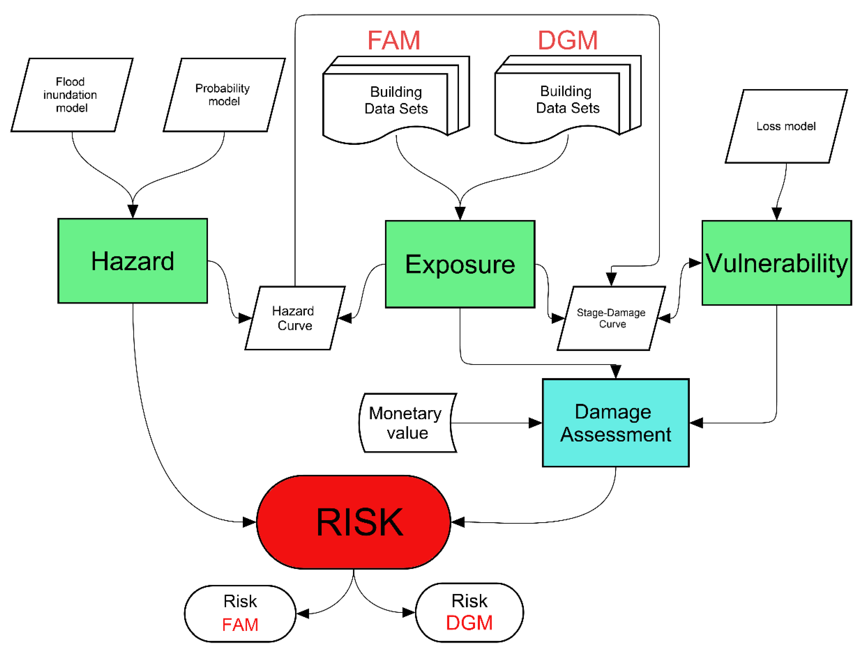
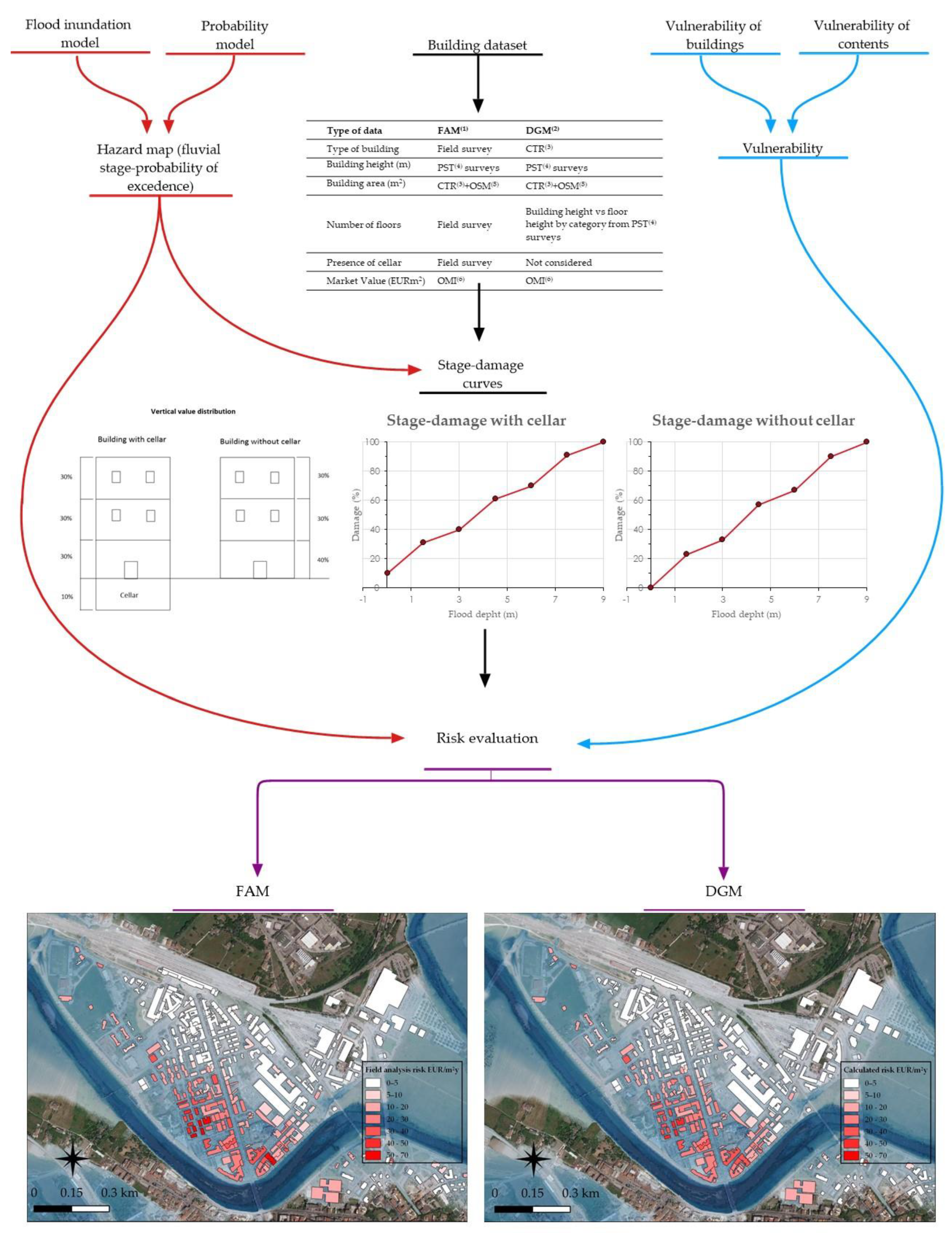
2. Materials and Methods
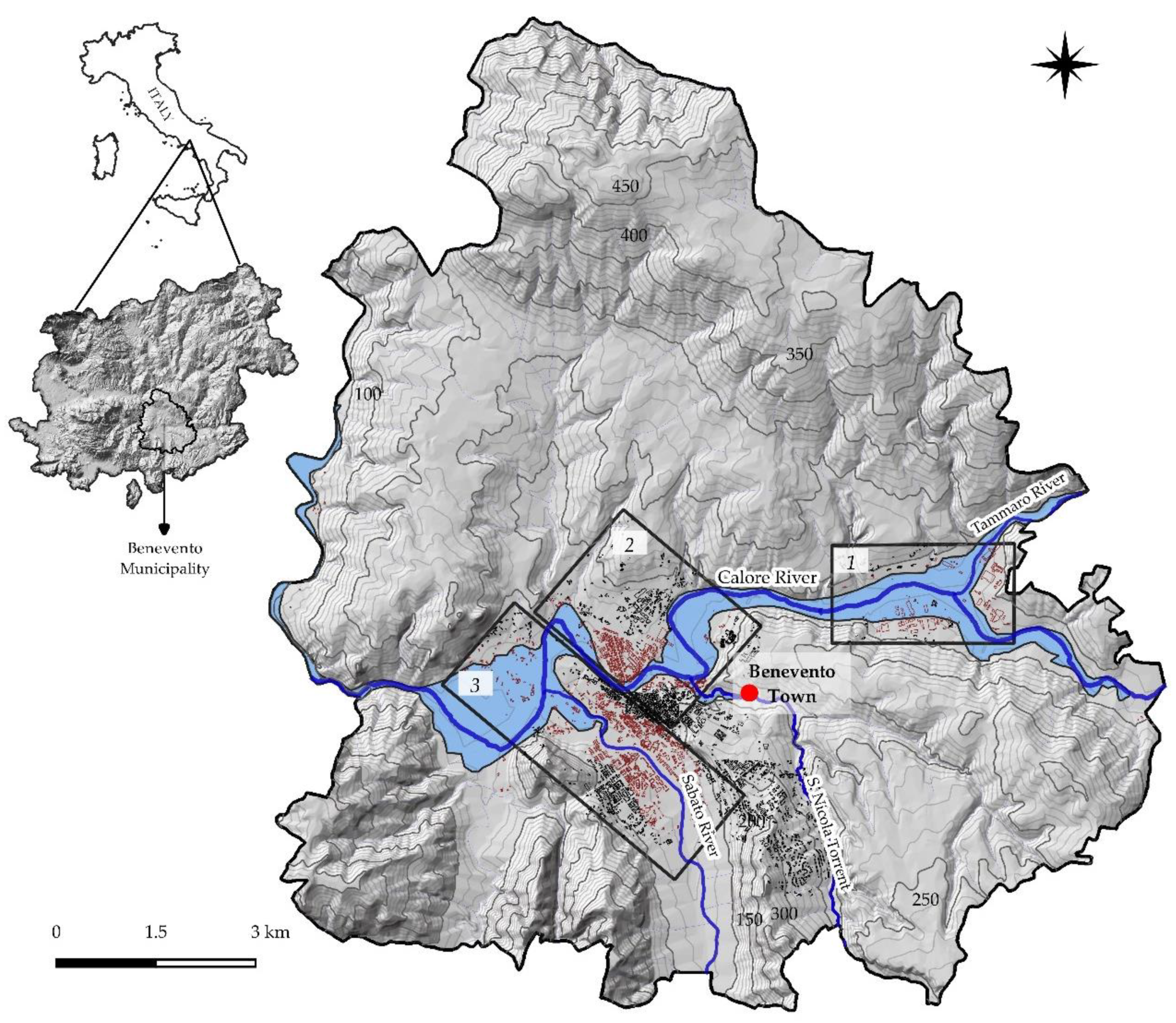
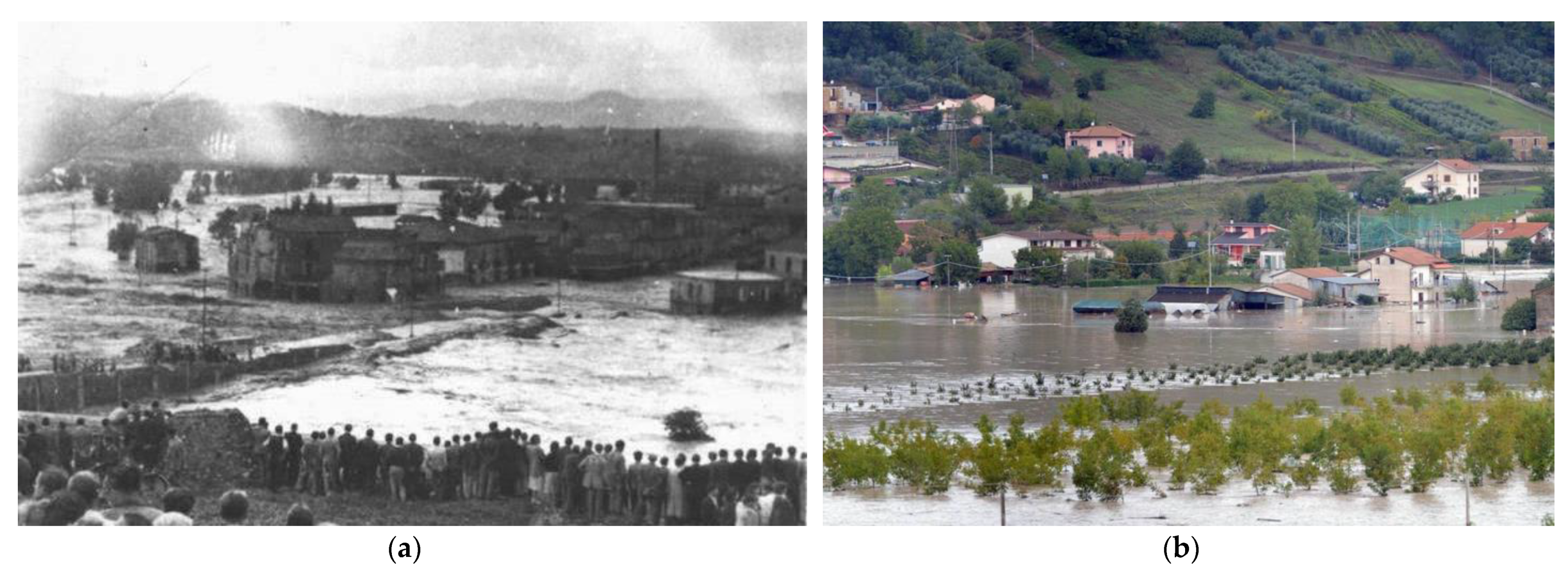
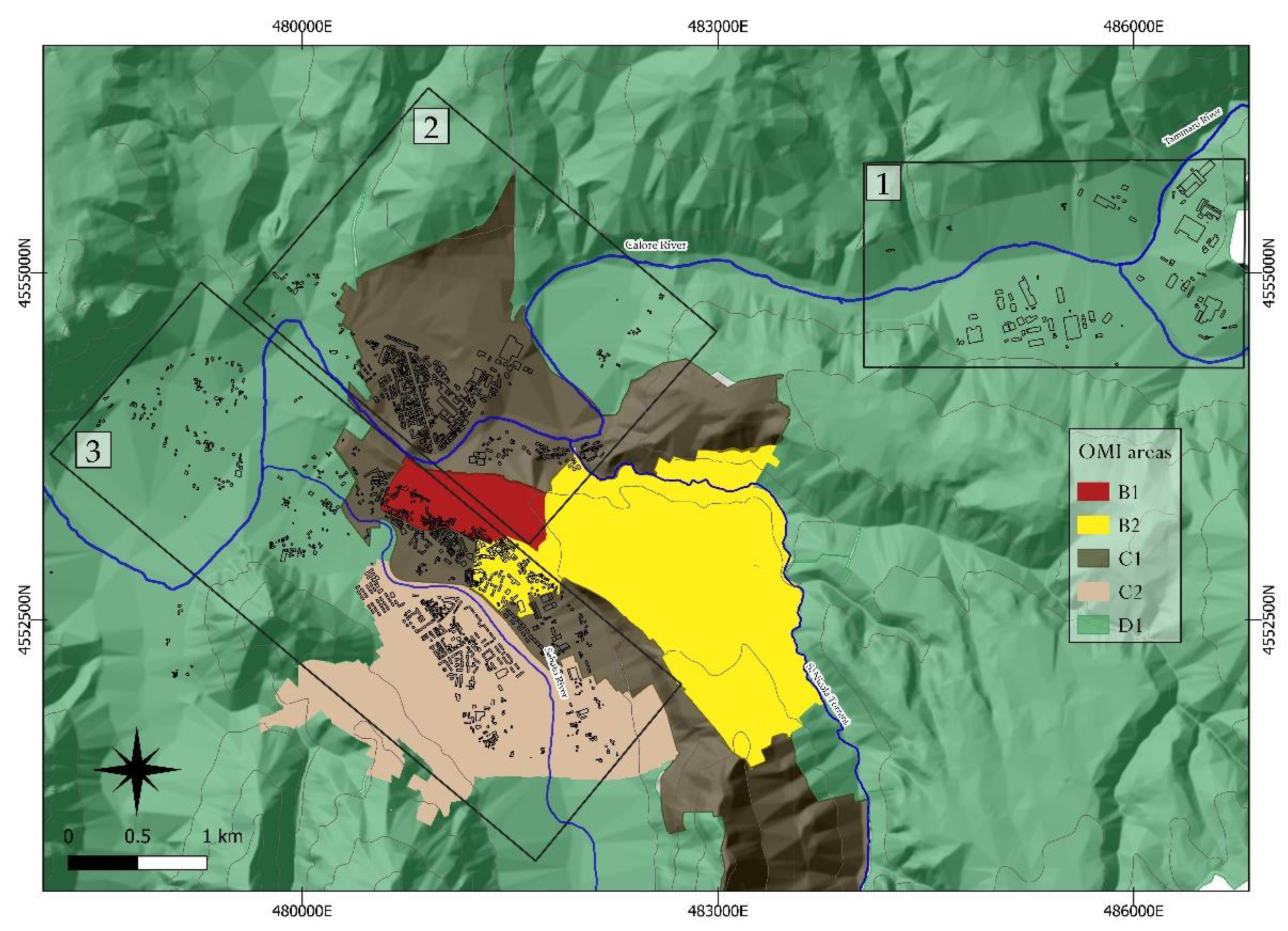
2.1. Study Area
2.2. Methods
- Definition and mapping of flood hazards (hazard, H);
- Definition of elements at risk from both FAM and DGM (exposure, E);
- Definition of the stage–damage curves (vulnerability, V);
- Definition of the building’s economic damage;
- Risk estimation (risk, R).

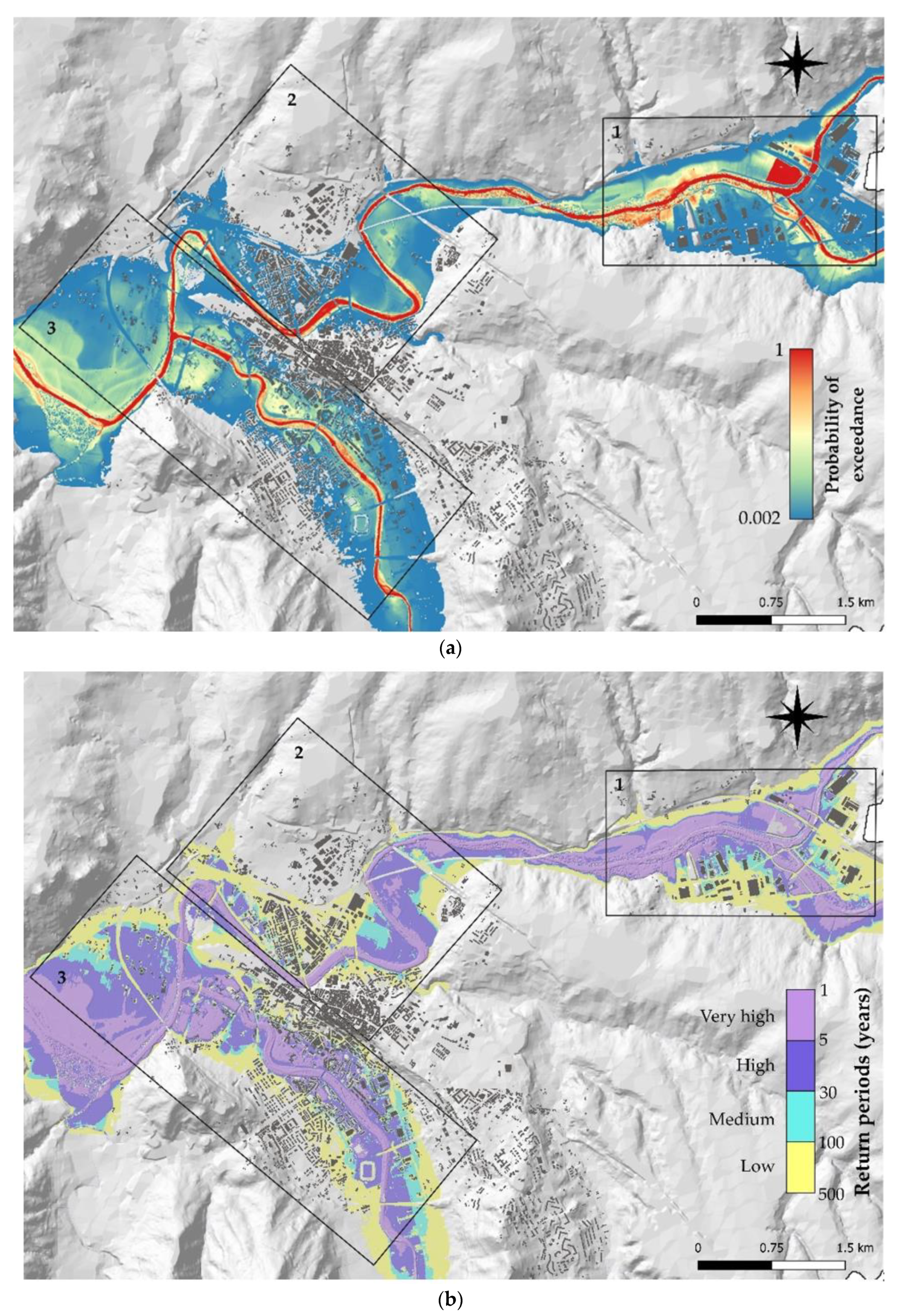
2.3. Hazards
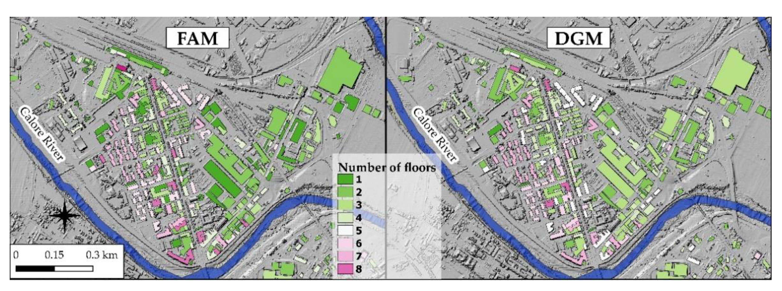
2.4. Elements Exposed at Risk
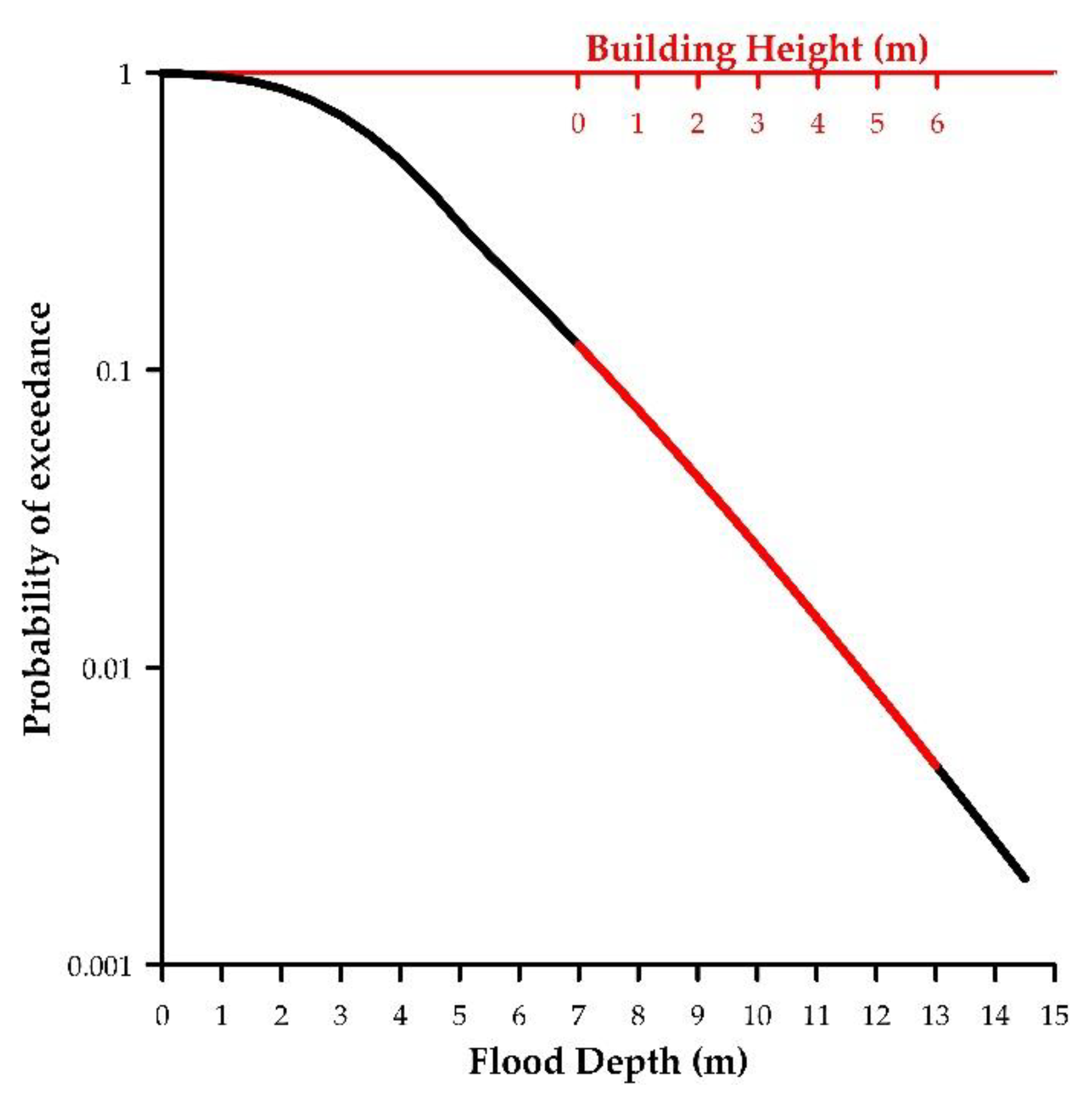
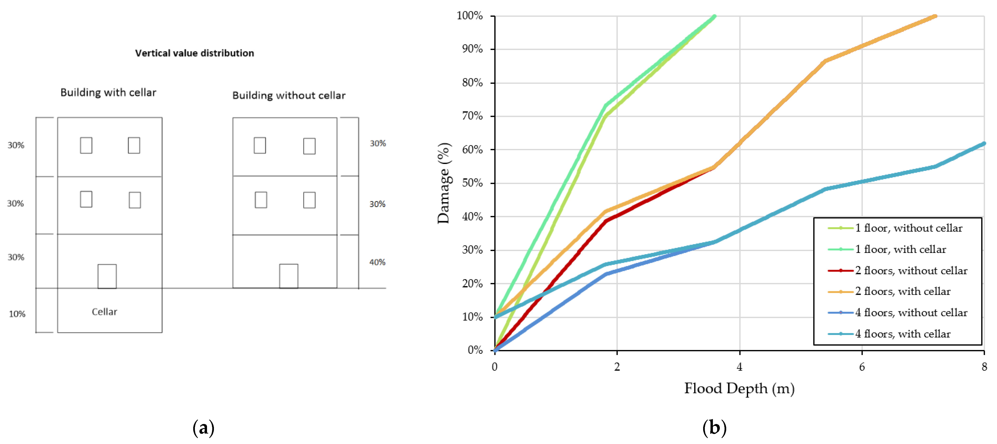
2.5. Stage–Damage Curves
2.6. Monetary Damage Estimate
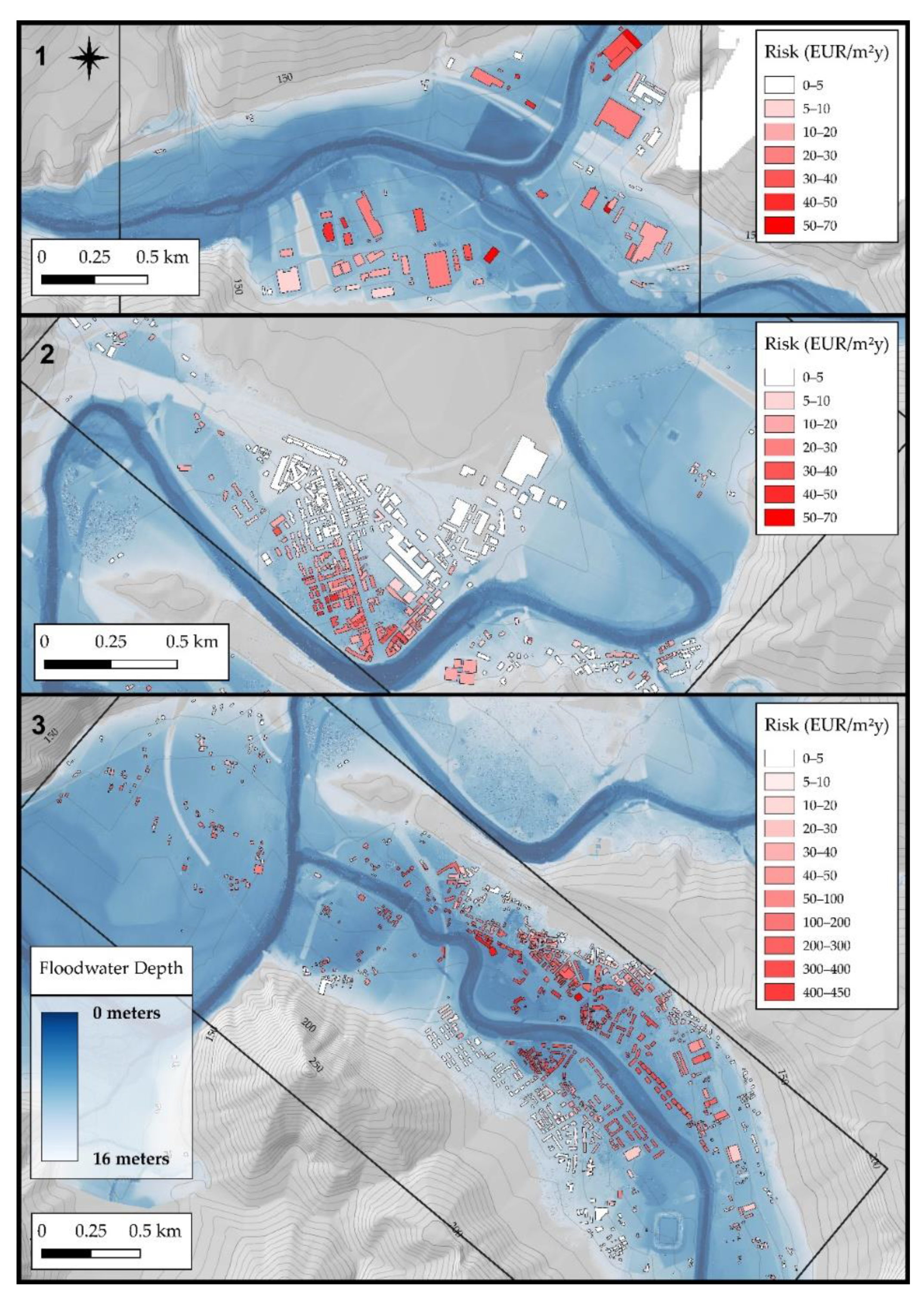
2.7. Risk Assessment
3. Results
3.1. Hazards
3.2. Elements Exposed to Risk
3.3. Stage–Damage Curves
3.4. Monetary Damage Estimate
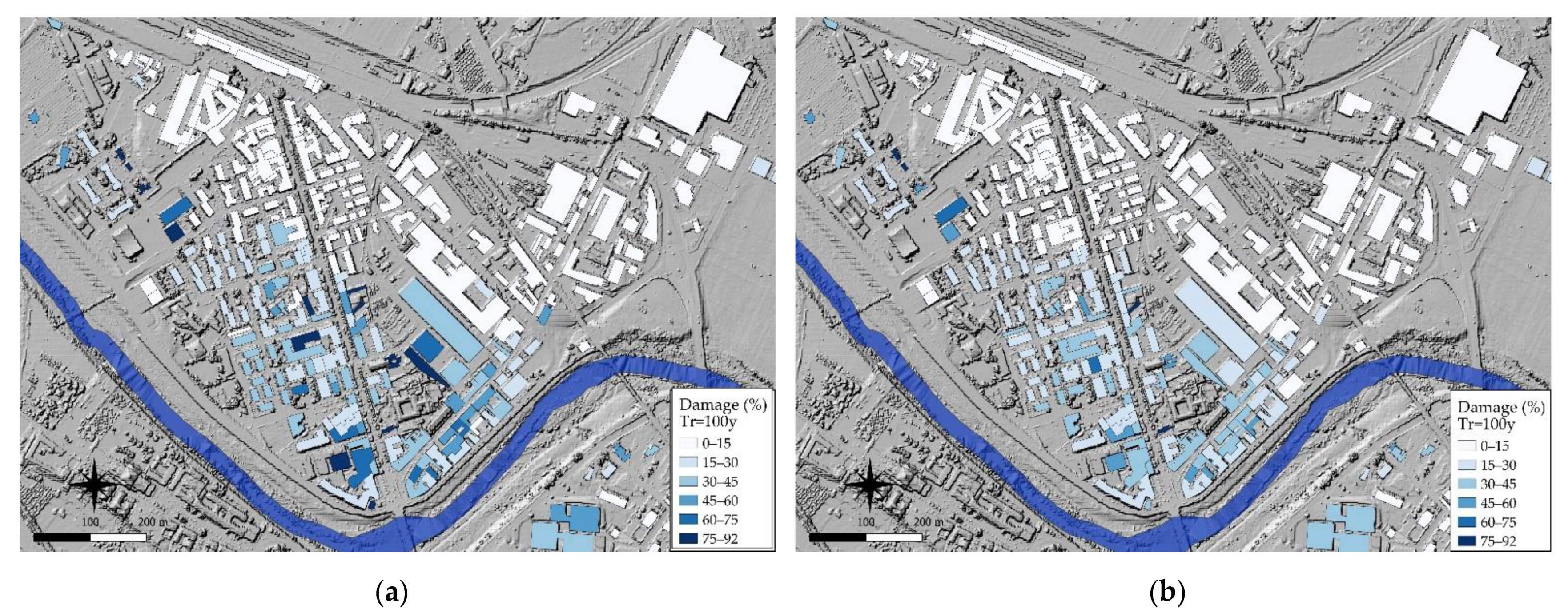
3.5. Risk Assessment
- Digital elevation model (DEM) and digital surface model (DSM) containing information about the territory;
- Water surface model and flood hazards;
- Layers of building types and characteristics: building identification number (GID), presence of cellar, number of floors, building height, building area, and type of building;
- Layers relating to the division of the OMI zones;
- Layers relating to stage–damage curves;
- Layers relating to the risk calculation.
4. Discussion
5. Conclusions
Author Contributions
Funding
Data Availability Statement
Conflicts of Interest
References
- Latour, B. Agency at the Time of the Anthropocene. New Lit. Hist. 2014, 45, 1–18. [Google Scholar] [CrossRef]
- Lippert, I. Latour’s Gaia—Not down to Earth? Social Studies of Environmental Management for Grounded Understandings of the Politics of Human-Nature Relationships; Institute for Advanced Studies on Science, Technology and Society: Graz, Austria, 2014. [Google Scholar] [CrossRef]
- Domeneghetti, A.; Carisi, F.; Castellarin, A.; Brath, A. Evolution of Flood Risk over Large Areas: Quantitative Assessment for the Po River. J. Hydrol. 2015, 527, 809–823. [Google Scholar] [CrossRef]
- Knox, J.C. Large Increases in Flood Magnitude in Response to Modest Changes in Climate. Nature 1993, 361, 430–432. [Google Scholar] [CrossRef]
- Groisman, P.Y.; Knight, R.W.; Easterling, D.R.; Karl, T.R.; Hegerl, G.C.; Razuvaev, V.N. Trends in Intense Precipitation in the Climate Record. J. Clim. 2005, 18, 1326–1350. [Google Scholar] [CrossRef]
- Dobler, C.; Bürger, G.; Stötter, J. Assessment of Climate Change Impacts on Flood Hazard Potential in the Alpine Lech Watershed. J. Hydrol. 2012, 460–461, 29–39. [Google Scholar] [CrossRef]
- Kundzewicz, Z.W.; Ulbrich, U.; Brücher, T.; Graczyk, D.; Krüger, A.; Leckebusch, G.C.; Menzel, L.; Pińskwar, I.; Radziejewski, M.; Szwed, M. Summer Floods in Central Europe—Climate Change Track? Nat. Hazards 2005, 36, 165–189. [Google Scholar] [CrossRef]
- Elmer, F.; Hoymann, J.; Duethmann, D.; Vorogushyn, S.; Kreibich, H. Drivers of Flood Risk Change in Residential Areas. Nat. Hazards Earth Syst. Sci. 2012, 12, 1641–1657. [Google Scholar] [CrossRef] [Green Version]
- Gu, C.; Mu, X.; Gao, P.; Zhao, G.; Sun, W.; Li, P. Effects of Climate Change and Human Activities on Runoff and Sediment Inputs of the Largest Freshwater Lake in China, Poyang Lake. Hydrol. Sci. J. 2017, 62, 2313–2330. [Google Scholar] [CrossRef]
- Wei, X.; Cai, S.; Ni, P.; Zhan, W. Impacts of Climate Change and Human Activities on the Water Discharge and Sediment Load of the Pearl River, Southern China. Sci. Rep. 2020, 10, 16743. [Google Scholar] [CrossRef]
- Ruzza, G.; Guerriero, L.; Grelle, G.; Guadagno, F.M.; Revellino, P. Multi-Method Tracking of Monsoon Floods Using Sentinel-1 Imagery. Water 2019, 11, 2289. [Google Scholar] [CrossRef] [Green Version]
- Bentivenga, M.; Giano, S.I.; Piccarreta, M. Recent Increase of Flood Frequency in the Ionian Belt of Basilicata Region, Southern Italy: Human or Climatic Changes? Water 2020, 12, 2062. [Google Scholar] [CrossRef]
- Mandarino, A.; Luino, F.; Faccini, F. Flood-Induced Ground Effects and Flood-Water Dynamics for Hydro-Geomorphic Hazard Assessment: The 21–22 October 2019 Extreme Flood along the Lower Orba River (Alessandria, NW Italy). J. Maps 2021, 17, 136–151. [Google Scholar] [CrossRef]
- Malota, M.; Mchenga, J. Revisiting Dominant Practices in Floodwater Harvesting Systems: Making Flood Events Worth Their Occurrence in Flood-Prone Areas. Appl. Water Sci. 2020, 10, 6. [Google Scholar] [CrossRef] [Green Version]
- Mazzorana, B.; Simoni, S.; Scherer, C.; Gems, B.; Fuchs, S.; Keiler, M. A Physical Approach on Flood Risk Vulnerability of Buildings. Hydrol. Earth Syst. Sci. 2014, 18, 3817–3836. [Google Scholar] [CrossRef] [Green Version]
- Bermúdez, M.; Zischg, A.P. Sensitivity of Flood Loss Estimates to Building Representation and Flow Depth Attribution Methods in Micro-Scale Flood Modelling. Nat. Hazards 2018, 92, 1633–1648. [Google Scholar] [CrossRef] [Green Version]
- Milanesi, L.; Pilotti, M.; Belleri, A.; Marini, A.; Fuchs, S. Vulnerability to Flash Floods: A Simplified Structural Model for Masonry Buildings. Water Resour. Res. 2018, 54, 7177–7197. [Google Scholar] [CrossRef]
- Cevasco, A.; Diodato, N.; Revellino, P.; Fiorillo, F.; Grelle, G.; Guadagno, F.M. Storminess and Geo-Hydrological Events Affecting Small Coastal Basins in a Terraced Mediterranean Environment. Sci. Total Environ. 2015, 532, 208–219. [Google Scholar] [CrossRef]
- Costabile, P.; Costanzo, C.; De Lorenzo, G.; Macchione, F. Is Local Flood Hazard Assessment in Urban Areas Significantly Influenced by the Physical Complexity of the Hydrodynamic Inundation Model? J. Hydrol. 2020, 580, 124231. [Google Scholar] [CrossRef]
- Ramos, H.M.; Besharat, M. Urban Flood Risk and Economic Viability Analyses of a Smart Sustainable Drainage System. Sustainability 2021, 13, 13889. [Google Scholar] [CrossRef]
- Burgess, C.P.; Taylor, M.A.; Stephenson, T.; Mandal, A.; Powell, L. A Macro-Scale Flood Risk Model for Jamaica with Impact of Climate Variability. Nat. Hazards 2015, 78, 231–256. [Google Scholar] [CrossRef]
- De Risi, R.; Jalayer, F.; De Paola, F. Meso-Scale Hazard Zoning of Potentially Flood Prone Areas. J. Hydrol. 2015, 527, 316–325. [Google Scholar] [CrossRef]
- Kreibich, H.; Schröter, K.; Merz, B. Up-Scaling of Multi-Variable Flood Loss Models from Objects to Land Use Units at the Meso-Scale. Proc. IAHS 2016, 373, 179–182. [Google Scholar] [CrossRef] [Green Version]
- Genovese, E. A Methodological Approach to Land Use-Based Flood Damage Assessment in Urban Areas: Prague Case Study; Technical EUR Reports; EUR: Luxembourg, 2006. [Google Scholar]
- Oliveri, E.; Santoro, M. Estimation of Urban Structural Flood Damages: The Case Study of Palermo. Urban Water 2000, 3, 223–234. [Google Scholar] [CrossRef]
- Ernst, J.; Dewals, B.; Detrembleur, S.; Archambeau, P.; Erpicum, S.; Pirotton, M. Micro-Scale Flood Risk Analysis Based on Detailed 2D Hydraulic Modelling and High Resolution Geographic Data. Nat. Hazards 2010, 55, 181–209. [Google Scholar] [CrossRef]
- Arrighi, C.; Brugioni, M.; Castelli, F.; Franceschini, S.; Mazzanti, B. Urban Micro-Scale Flood Risk Estimation with Parsimonious Hydraulic Modelling and Census Data. Nat. Hazards Earth Syst. Sci. 2013, 13, 1375–1391. [Google Scholar] [CrossRef] [Green Version]
- Hasanzadeh Nafari, R.; Amadio, M.; Ngo, T.; Mysiak, J. Flood Loss Modelling with FLF-IT: A New Flood Loss Function for Italian Residential Structures. Nat. Hazards Earth Syst. Sci. 2017, 17, 1047–1059. [Google Scholar] [CrossRef] [Green Version]
- Diodato, N. Ricostruzione storica di eventi naturali estremia carattere idrometeorologico nel sannio beneventanodal medioevo al 1998. Boll. Geofis. 1999, 22, 5–39. [Google Scholar]
- Diodato, N. Climatic Fluctuations in Southern Italy since the 17th Century: Reconstruction with Precipitation Records at Benevento. Clim. Change 2007, 80, 411–431. [Google Scholar] [CrossRef]
- Santo, A.; Santangelo, N.; Forte, G.; De Falco, M. Post Flash Flood Survey: The 14th and 15th October 2015 Event in the Paupisi-Solopaca Area (Southern Italy). J. Maps 2017, 13, 19–25. [Google Scholar] [CrossRef] [Green Version]
- Revellino, P.; Guerriero, L.; Mascellaro, N.; Fiorillo, F.; Grelle, G.; Ruzza, G.; Guadagno, F.M. Multiple Effects of Intense Meteorological Events in the Benevento Province, Southern Italy. Water 2019, 11, 1560. [Google Scholar] [CrossRef] [Green Version]
- Guerriero, L.; Focareta, M.; Fusco, G.; Rabuano, R.; Guadagno, F.M.; Revellino, P. Flood Hazard of Major River Segments, Benevento Province, Southern Italy. J. Maps 2018, 14, 597–606. [Google Scholar] [CrossRef] [Green Version]
- Guerriero, L.; Ruzza, G.; Calcaterra, D.; Di Martire, D.; Guadagno, F.M.; Revellino, P. Modelling Prospective Flood Hazard in a Changing Climate, Benevento Province, Southern Italy. Water 2020, 12, 2405. [Google Scholar] [CrossRef]
- Grelle, G.; Rossi, A.; Revellino, P.; Guerriero, L.; Guadagno, F.M.; Sappa, G. Assessment of Debris-Flow Erosion and Deposit Areas by Morphometric Analysis and a GIS-Based Simplified Procedure: A Case Study of Paupisi in the Southern Apennines. Sustainability 2019, 11, 2382. [Google Scholar] [CrossRef] [Green Version]
- Magliulo, P.; Valente, A. GIS-Based Geomorphological Map of the Calore River Floodplain Near Benevento (Southern Italy) Overflooded by the 15th October 2015 Event. Water 2020, 12, 148. [Google Scholar] [CrossRef] [Green Version]
- Zazo, A. Lo straripamento del fiume Calore in Benevento nel 1740 e nel 1770. Samnium 1949, 3–4, 212. [Google Scholar]
- Andriola, L.; Delmonaco, G.; Margottini, C.; Serafini, S.; Trocciola, A. Andamenti Meteoclimatici Ed Eventi Naturali Estremi in Italia Negli Ultimi 1000 Anni: Alcune Esperienze Nell’ ENEA. Atti Dei Convegni Lincei-Accad. Naz. Dei Lincei 1995, 129, 95–116. [Google Scholar]
- Cardinali, M.; Cipolla, F.; Guzzetti, F.; Lolli, O.; Pagliacci, S.; Reichenbach, P.; Tonelli, G. Catalogo Delle Informazioni Sulle Località Italiane Colpite Da Frane e Di Inondazioni; Consiglio nazionale delle ricerche: Rome, Italy, 1998. [Google Scholar]
- Rossi, F.; Villani, P. Valutazione Delle Piene in Campania; Rapporto Regionale Campania; CNR-GNDCI. 1994. Available online: http://www.gndci.cnr.it/it/vapi/welcome_it.htm (accessed on 1 May 2018).
- Diodato, N.; Soriano, M.; Bellocchi, G.; Fiorillo, F.; Cevasco, A.; Revellino, P.; Guadagno, F.M. Historical Evolution of Slope Instability in the Calore River Basin, Southern Italy. Geomorphology 2017, 282, 74–84. [Google Scholar] [CrossRef]
- Office of the United Nations Disaster Relief Coordinator. Natural Disasters and Vulnerability Analysis. 1980. Available online: https://digitallibrary.un.org/record/95986 (accessed on 1 September 2017).
- Varnes, D.J.; IAEG Commission. Landslide hazard zonation: A review of principles and practice; UNESCO Press: Paris, France, 1984; 63p. [Google Scholar]
- Uddin, K.; Matin, M.A. Potential Flood Hazard Zonation and Flood Shelter Suitability Mapping for Disaster Risk Mitigation in Bangladesh Using Geospatial Technology. Prog. Disaster Sci. 2021, 11, 100185. [Google Scholar] [CrossRef]
- Guerriero, L.; Ruzza, G.; Guadagno, F.M.; Revellino, P. Flood Hazard Mapping Incorporating Multiple Probability Models. J. Hydrol. 2020, 587, 125020. [Google Scholar] [CrossRef]
- Montané, A.; Buffin-Bélanger, T.; Vinet, F.; Vento, O. Mappings Extreme Floods with Numerical Floodplain Models (NFM) in France. Appl. Geogr. 2017, 80, 15–22. [Google Scholar] [CrossRef]
- Scorpio, V.; Rosskopf, C.M. Channel Adjustments in a Mediterranean River over the Last 150 Years in the Context of Anthropic and Natural Controls. Geomorphology 2016, 275, 90–104. [Google Scholar] [CrossRef]
- Sutcliffe, J.V. The Use of Historical Records in Flood Frequency Analysis. J. Hydrol. 1987, 96, 159–171. [Google Scholar] [CrossRef]
- Woo, M.; Waylen, P.R. Probability Studies of Floods. Appl. Geogr. 1986, 6, 185–195. [Google Scholar] [CrossRef]
- Hosking, J.R.M.; Wallis, J.R. The Value of Historical Data in Flood Frequency Analysis. Water Resour. Res. 1986, 22, 1606–1612. [Google Scholar] [CrossRef] [Green Version]
- Yue, S. A Bivariate Gamma Distribution for Use in Multivariate Flood Frequency Analysis. Hydrol. Processes 2001, 15, 1033–1045. [Google Scholar] [CrossRef]
- Mojtahedi, M.; Oo, B.L. Built Infrastructure Conditions Mediate the Relationship between Stakeholders Attributes and Flood Damage: An Empirical Case Study. Sustainability 2021, 13, 9739. [Google Scholar] [CrossRef]
- Agenzia Delle Entrate: Sintesi Degli Studi Di Settore. Available online: https://www.agenziaentrate.gov.it/portale/web/guest/archivio/archivioschedeadempimento/schede-adempimento-2018/dichiarazioni/studisettore (accessed on 25 June 2018).
- Kang, J.-L.; Su, M.-D.; Chang, L.-F. Loss functions and framework for regional flood damage estimation in residential area. J. Mar. Sci. Technol. 2005, 13, 5. [Google Scholar] [CrossRef]
- Luino, F.; Cirio, C.G.; Biddoccu, M.; Agangi, A.; Giulietto, W.; Godone, F.; Nigrelli, G. Application of a Model to the Evaluation of Flood Damage. Geoinformatica 2009, 13, 339–353. [Google Scholar] [CrossRef]
- Jordan, S.; Jørgensen, L.; Mitterhofer, H. Performing Risk and the Project: Risk Maps as Mediating Instruments. Manag. Account. Res. 2013, 24, 156–174. [Google Scholar] [CrossRef]
- Kalthoff, H. Practices of Calculation: Economic Representations and Risk Management. Theory Cult. Soc. 2005, 22, 69–97. [Google Scholar] [CrossRef]
- US Army corpsHydrologic Engineerin Center HEC-FIA Flood Impact Analysis, User’s Manual. Available online: https://www.hec.usace.army.mil/software/hec-fia/documentation/HEC-FIA_30_Users_Manual.pdf (accessed on 25 June 2018).
- Karagiorgos, K.; Thaler, T.; Hübl, J.; Maris, F.; Fuchs, S. Multi-Vulnerability Analysis for Flash Flood Risk Management. Nat. Hazards 2016, 82, 63–87. [Google Scholar] [CrossRef] [Green Version]
- Themsen, T.N.; Skærbæk, P. The Performativity of Risk Management Frameworks and Technologies: The Translation of Uncertainties into Pure and Impure Risks. Account. Organ. Soc. 2018, 67, 20–33. [Google Scholar] [CrossRef]


| Type of Data | FAM (1) | DGM (2) | |
|---|---|---|---|
| 1 | Type of building | Field survey | CTR (3) |
| 2 | Building height (m) | PST (4) surveys | PST (4) surveys |
| 3 | Building area (m2) | CTR (3) + OSM (5) | CTR (3) + OSM (5) |
| 4 | Number of floors | Field survey | Building height vs. floor height by category from PST (4) surveys |
| 5 | Presence of cellar | Field survey | Not considered |
| 6 | Market Value (EURm2) | OMI (6) | OMI (6) |
| Type of Building (FAM and DGM) | Floor Height (m) (DGM) |
|---|---|
| Civil dwellings, economic housing | 3.6 |
| Parking garages, box, villas | 3.2 |
| Offices, structured offices | 3.7 |
| Industrial sheds, typical warehouses, laboratories | 4.5 |
| Shopping centers, stores, shops | 4.6 |
| Other | 4.3 |
| Types of Building | f (1) |
|---|---|
| Civil dwellings, economic housing, villas | 0.50 |
| Industrial sheds | 3.50 |
| Parking garages, boxes, shopping centers, stores, shops, offices, structured offices, laboratories, typical warehouses | 2.00 |
| FAM (M EUR/y) | DGM (M EUR/y) | Difference (%) | |
|---|---|---|---|
| Total buildings | ≈29.35 | ≈28.36 | 3.35 |
| Industrial area | ≈4.06 | ≈4.06 | 0.002 |
| Rione Ferrovia area | ≈1.97 | ≈1.75 | 10.36 |
| Rione Libertà area | ≈23.32 | ≈22.54 | 3.34 |
| Typology | Number of Buildings | FAM (M EUR/y) | DGM (M EUR/y) | Difference (%) |
|---|---|---|---|---|
| Total buildings | 1533 | ≈29.35 | ≈28.36 | 3.35 |
| Civil dwellings | 893 | ≈14.59 | ≈13.78 | 5.54 |
| Economic housing | 94 | ≈0.49 | ≈0.48 | 0.76 |
| Garages | 12 | ≈0.76 | ≈0.73 | 2.80 |
| Boxes | 89 | ≈0.26 | ≈0.26 | 0.07 |
| Villas | 3 | ≈0.0037 | ≈0.0037 | 0.00 |
| Shopping centers | 5 | ≈0.13 | ≈0.12 | 2.72 |
| Stores | 21 | ≈1.06 | ≈1.06 | 0.00 |
| Shops | 67 | ≈4.30 | ≈4.29 | 0.15 |
| Offices | 60 | ≈2.19 | ≈1.98 | 6.50 |
| Structured offices | 4 | ≈0.15 | ≈0.15 | 0.00 |
| Industrial sheds | 149 | ≈4.63 | ≈4.63 | 0.02 |
| Typical warehouses | 125 | ≈0.27 | ≈0.27 | 0.00 |
| Workshops | 11 | ≈0.60 | ≈0.60 | 0.00 |
| Typology | Number of Buildings | FAM | DGM | Difference % |
|---|---|---|---|---|
| Without cellar | 1281 | ≈22.34 | ≈22.34 | 0.0002 |
| With cellar | 252 | ≈4.94 | ≈3.96 | 19.87 |
Publisher’s Note: MDPI stays neutral with regard to jurisdictional claims in published maps and institutional affiliations. |
© 2022 by the authors. Licensee MDPI, Basel, Switzerland. This article is an open access article distributed under the terms and conditions of the Creative Commons Attribution (CC BY) license (https://creativecommons.org/licenses/by/4.0/).
Share and Cite
Festa, G.I.; Guerriero, L.; Focareta, M.; Meoli, G.; Revellino, S.; Guadagno, F.M.; Revellino, P. Calculating Economic Flood Damage through Microscale Risk Maps and Data Generalization: A Pilot Study in Southern Italy. Sustainability 2022, 14, 6286. https://doi.org/10.3390/su14106286
Festa GI, Guerriero L, Focareta M, Meoli G, Revellino S, Guadagno FM, Revellino P. Calculating Economic Flood Damage through Microscale Risk Maps and Data Generalization: A Pilot Study in Southern Italy. Sustainability. 2022; 14(10):6286. https://doi.org/10.3390/su14106286
Chicago/Turabian StyleFesta, Gianna Ida, Luigi Guerriero, Mariano Focareta, Giuseppe Meoli, Silvana Revellino, Francesco Maria Guadagno, and Paola Revellino. 2022. "Calculating Economic Flood Damage through Microscale Risk Maps and Data Generalization: A Pilot Study in Southern Italy" Sustainability 14, no. 10: 6286. https://doi.org/10.3390/su14106286
APA StyleFesta, G. I., Guerriero, L., Focareta, M., Meoli, G., Revellino, S., Guadagno, F. M., & Revellino, P. (2022). Calculating Economic Flood Damage through Microscale Risk Maps and Data Generalization: A Pilot Study in Southern Italy. Sustainability, 14(10), 6286. https://doi.org/10.3390/su14106286