System-Level Performance Analysis of Cooperative Multiple Unmanned Aerial Vehicles for Wildfire Surveillance Using Agent-Based Modeling
Abstract
:1. Introduction
- How can the estimation of system-level performance measures of MUAV wildfire monitoring be achieved?
- Would such an assessment be helpful in the planning, resource allocation, and creating an optimal team formation for wildfire monitoring?
- To model and simulate an MUAV wildfire surveillance and monitoring system for effective resource management and planning.
- To analyze the effect of different surveillance strategies on the overall system performance.
- To estimate the impact of forest density (fire fuel) on the team size and formation of an MUAV performing fire surveillance.
- We have proposed simulations of different strategies, i.e., random strategy, two-layer barrier sweep coverage strategy and full sweep with local communication, and full sweep with global communication strategy. The results are evaluated by comparing each of the above strategies.
- The simulation and analyses of different strategies are presented to show each strategy’s performance and resources efficiencies.
- The analysis of the simulation is performed using statistical methods, an Analysis of Variance (ANOVA) to a confidence level of 0.01.
2. Related Work
3. Model Definition
3.1. Allocation Strategies
3.1.1. Random Strategy
| Algorithm 1 Random Strategy |
|
3.1.2. Two-Layer Sweep Strategy
| Algorithm 2 Two-Layer Barrier Strategy |
|
3.1.3. Sweep Coverage Strategy
| Algorithm 3 Sweep Coverage Strategy |
|
3.2. Cooperative Behavior: Refueling
3.3. The Forest Fire Model
- A burnt cell turns into an empty cell that cannot ignite.
- Any tree may ignite with probability f.
- A burning tree will ignite at least one of its neighbors.
- A space fills with a tree with probability p (density).
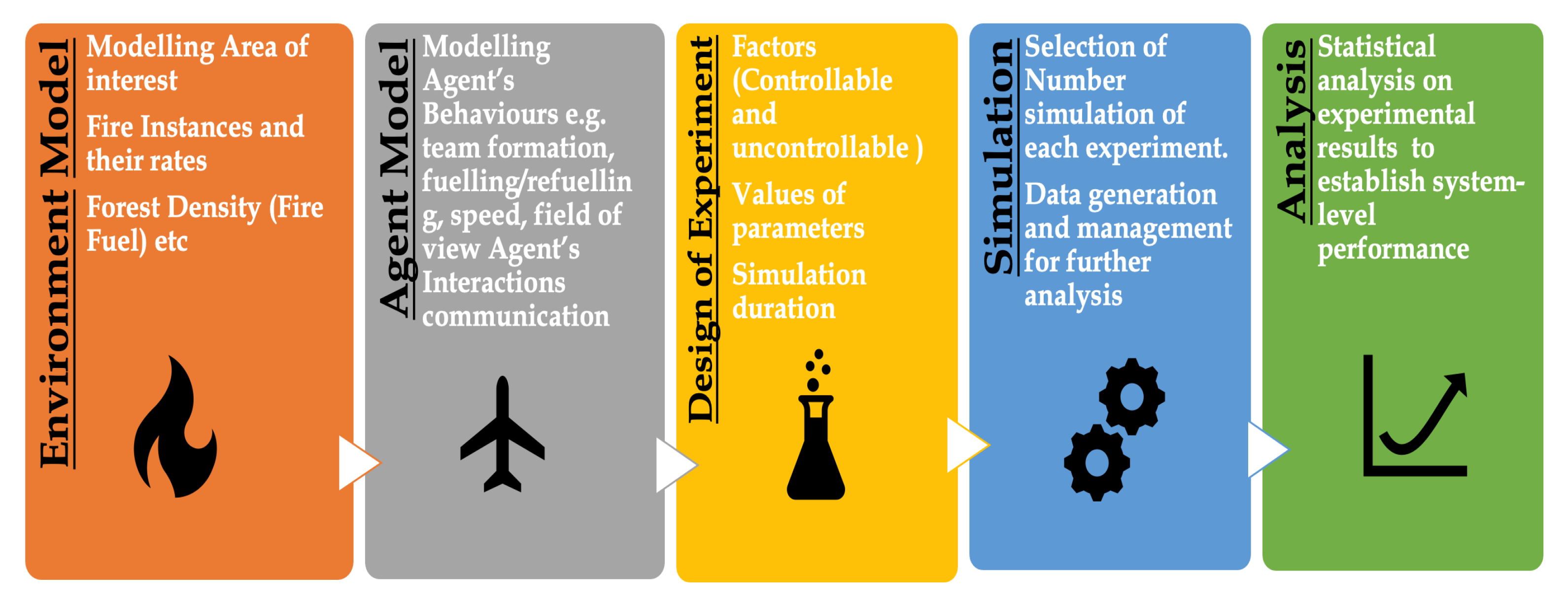
4. Design of Experiment
- To establish the working of ABM, our first experiment estimates the effects of size on overall system performance.
- Our second experiment simulates different team organizations for area coverage to access the impact of surveillance strategy on the performance.
- In our third experiment, we introduced UAV downtime for refueling and estimated its effects on overall performance.
- For our fourth setup, we introduced local and global communication constraints to check if the range of communication makes any significant difference.
- Last but not least, in our fifth experiment, we simulated MUAV fire monitoring on a different level of forest density.
5. Simulations
5.1. Experiment 1
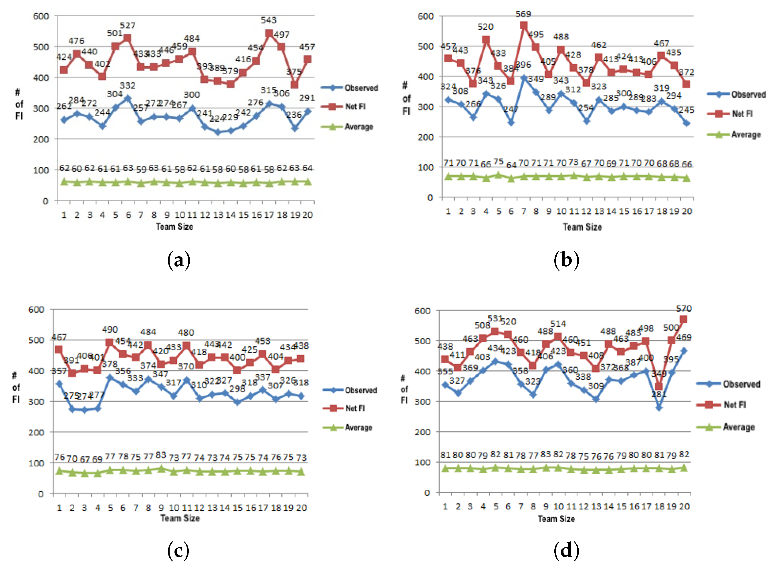
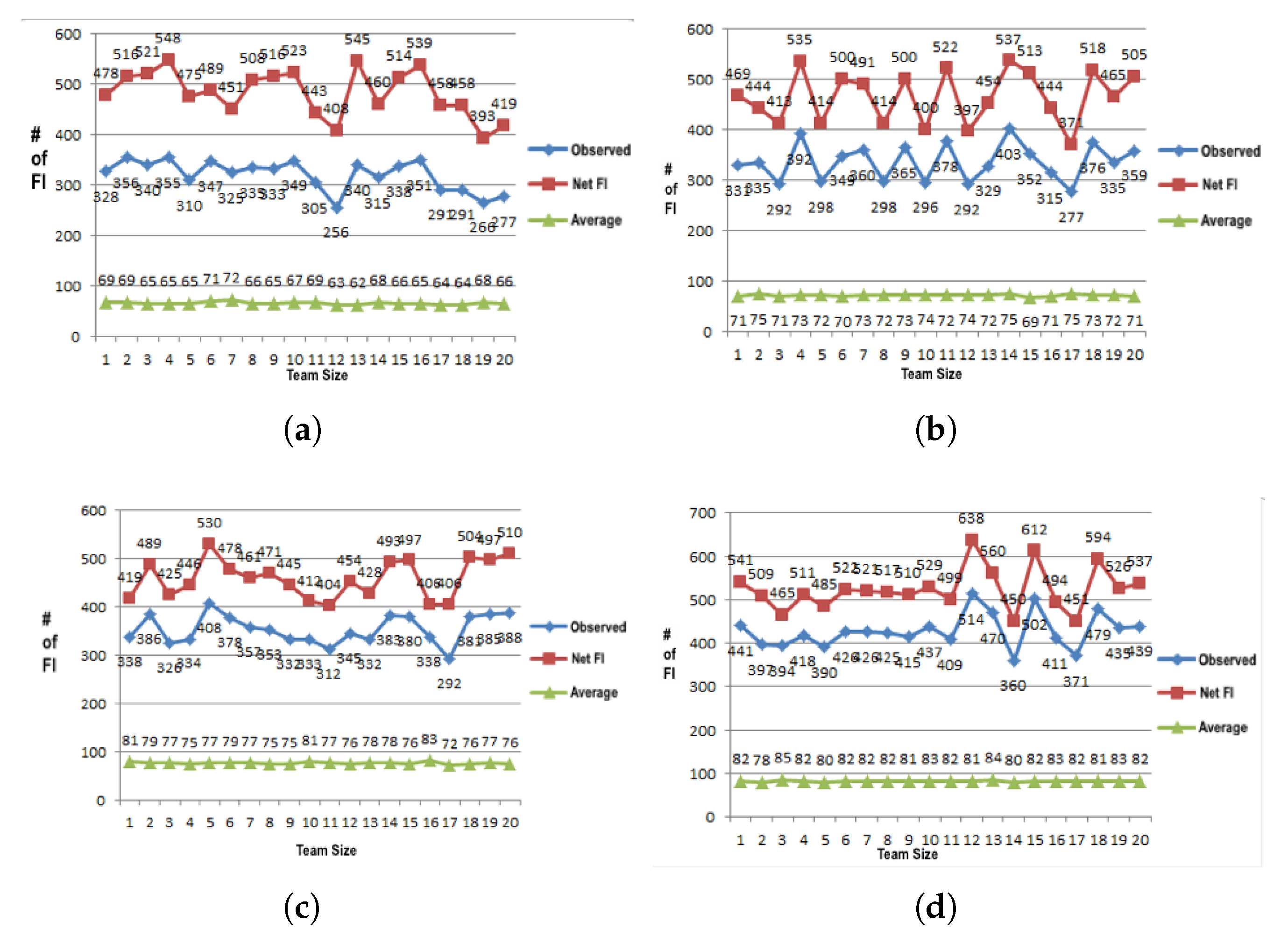
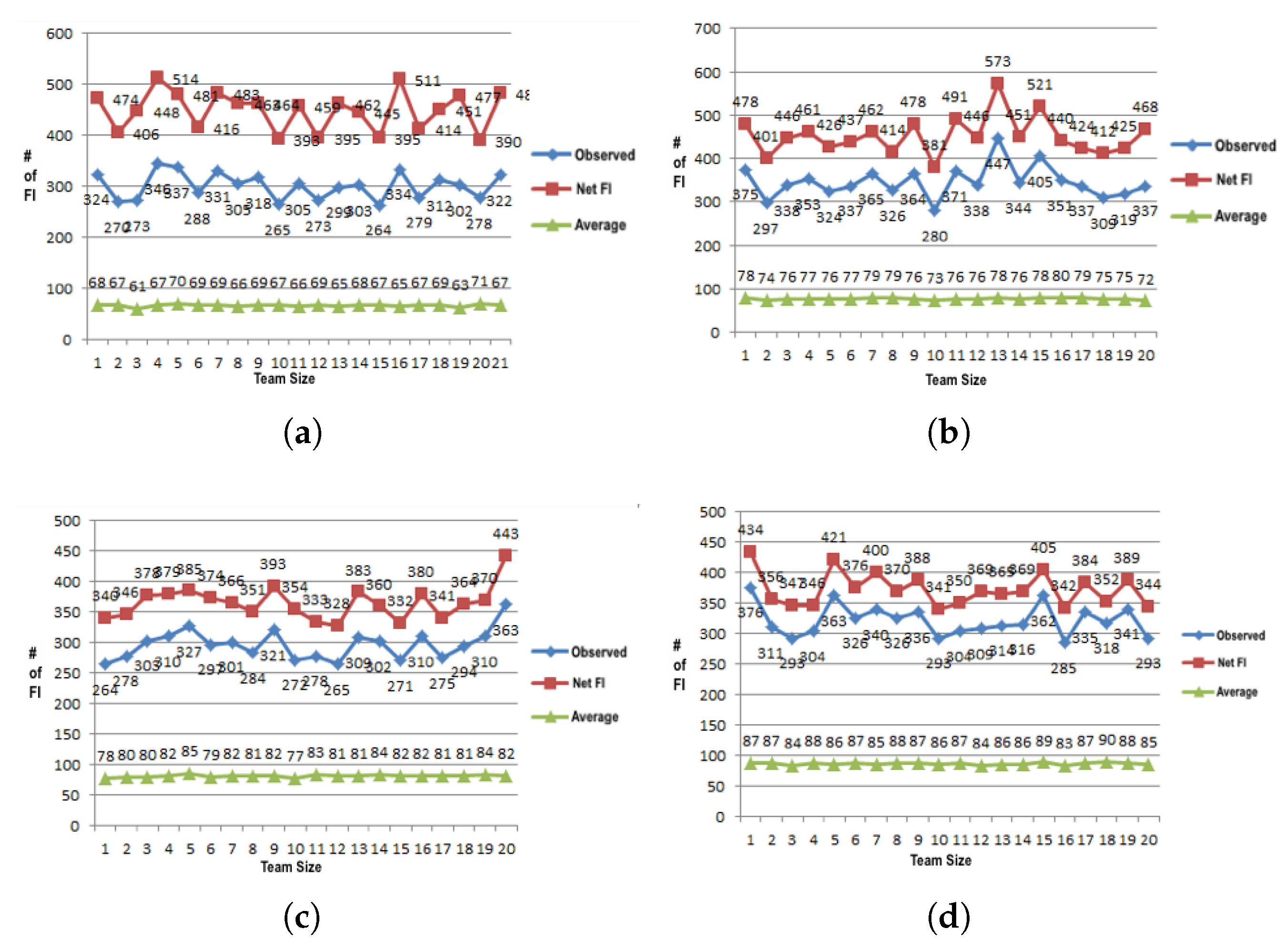
5.1.1. UAV Team-Size Effect on the Surveillance Performance
Random Strategy
Two-Layer Barrier Strategy
Full Sweep Coverage with Local Communication
Full Sweep Strategy with Global Communication
Analysis of Data
5.2. Experiment 2
Different Strategy-Effect Surveillance Performance
5.3. Experiment 3
5.4. Experiment 4
5.5. Experiment 5
- The workspace size is increased from (50 × 50) to (250 × 250).
- A team of MUAVs performs surveillance of the forest.
- The surveillance is performed either in a random or full-coverage arrangement.
- When a UAV approaches near a burning tree, it reduces the burnout rate of the surrounding trees from 0.6 to 0.4.
- The UAV looks for any breakout in its vicinity to reduce the burnout rate of any burning trees in a range.
- Each experiment is repeated 20 times.
6. Results and Discussion
7. Conclusions
Author Contributions
Funding
Institutional Review Board Statement
Informed Consent Statement
Data Availability Statement
Conflicts of Interest
Abbreviations
| ABM | Agent-Based Modeling |
| ANOVA | Analysis of Variance |
| FFM | Forest Fire Monitoring |
| FI | Fire Instance |
| MNTSC | Min-Nodes Timely Sweep Coverage |
| M-UAV | Multiple Unmanned Autonomous Vehicles |
| M-WSN | Multiple Wireless Sensor Network |
| NP-Hard | Non Polynomial |
| OI | object of interest |
| UAV | Unmanned Autonomous Vehicles |
| Notationsused in UAV Model | |
| Area under surveillance by watch agent i | |
| Distance between FI and watch agent | |
| E | Net area of surveillance i |
| ith section of E | |
| Field of view of watch agent i | |
| r | Radius of watch agent’s sensors range |
| T | All FIs |
| Watch agent heading i | |
| ith FI i | |
| Watch agent’s location on y axis | |
| FI location on y axis | |
| W | Set of watch agents |
| Watch agent i | |
| Maximum value of x coordinate of E | |
| Minimum value of x coordinate of E | |
| FI location on x axis | |
| Watch agent’s location on x axis | |
| Maximum value y coordinate of E | |
| Minimum value of y coordinate of E | |
| Forest density | |
| Neighborhood Burnout Probability |
References
- World Health Organization. Wildfires, Version 1.6.0. Available online: https://www.who.int/health-topics/wildfires#tab=tab_1 (accessed on 3 April 2022).
- Cima. FireRS. Available online: http://www.fire-rs.com/en/ (accessed on 3 April 2022).
- COMETS Proj.—Fire Monit. Available online: http://www.comets-uavs.org/applications/fire.shtml (accessed on 3 April 2022).
- Yu, Z.; Zhang, Y.; Jiang, B.; Yu, X. Fault-tolerant time-varying elliptical formation control of multiple fixed-wing UAVs for Cooperative Forest Fire Monitoring. J. Intell. Robot. Syst. 2021, 101, 48. [Google Scholar] [CrossRef]
- Fu, X.; Bi, H.; Gao, X. Multi-UAVs cooperative localization algorithms with communication constraints. Math. Probl. Eng. 2017, 2017, 1943539. [Google Scholar] [CrossRef] [Green Version]
- Farmani, N.; Sun, L.; Pack, D. Tracking multiple mobile targets using cooperative unmanned aerial vehicles. In Proceedings of the 2015 International conference on unmanned aircraft systems (ICUAS), Denver, CO, USA, 9–12 June 2015; pp. 395–400. [Google Scholar]
- Jones, P.J. Cooperative Area Surveillance Strategies Using Multiple Unmanned Systems; Georgia Institute of Technology: Atlanta, GA, USA, 2009. [Google Scholar]
- Drossel, B.; Schwabl, F. Self-organized critical forest-fire model. Phys. Rev. Lett. 1992, 69, 1629. [Google Scholar] [CrossRef] [PubMed] [Green Version]
- Wilensky, U. NetLogo Fire Model; Center for Connected Learning and Computer-Based Modeling, Northwestern University: Evanston, IL, USA, 1997; Available online: http://ccl.northwestern.edu/netlogo/models/Fire (accessed on 3 April 2022).
- Salavati, G.; Saniei, E.; Ghaderpour, E.; Hassan, Q.K. Wildfire Risk Forecasting Using Weights of Evidence and Statistical Index Models. Sustainability 2022, 14, 3881. [Google Scholar] [CrossRef]
- Summers, J.K.; Lamper, A.; McMillion, C.; Harwell, L.C. Observed Changes in the Frequency, Intensity, and Spatial Patterns of Nine Natural Hazards in the United States from 2000 to 2019. Sustainability 2022, 14, 4158. [Google Scholar] [CrossRef]
- Hosseini, M.; Lim, S. Gene expression programming and ensemble methods for bushfire susceptibility mapping: A case study of Victoria, Australia. Geomat. Nat. Hazards Risk 2021, 12, 2367–2386. [Google Scholar] [CrossRef]
- Khastagir, A.; Hossain, I.; Aktar, N. Evaluation of different parameter estimation techniques in extreme bushfire modelling for Victoria, Australia. Urban Clim. 2021, 37, 100862. [Google Scholar] [CrossRef]
- Sharma, S.K.; Aryal, J.; Rajabifard, A. Remote Sensing and Meteorological Data Fusion in Predicting Bushfire Severity: A Case Study from Victoria, Australia. Remote Sens. 2022, 14, 1645. [Google Scholar] [CrossRef]
- Lin, Z.; Liu, H.H.; Wotton, M. Kalman filter-based large-scale wildfire monitoring with a system of UAVs. IEEE Trans. Ind. Electron. 2018, 66, 606–615. [Google Scholar] [CrossRef]
- Moulianitis, V.; Thanellas, G.; Xanthopoulos, N.; Aspragathos, N.A. Evaluation of UAV based schemes for forest fire monitoring. In Proceedings of the International Conference on Robotics in Alpe-Adria Danube Region, Patras, Greece, 6–8 June 2018; Springer: Berlin/Heidelberg, Germany, 2018; pp. 143–150. [Google Scholar]
- Casbeer, D.W.; Kingston, D.B.; Beard, R.W.; McLain, T.W. Cooperative forest fire surveillance using a team of small unmanned air vehicles. Int. J. Syst. Sci. 2006, 37, 351–360. [Google Scholar] [CrossRef]
- Bailon-Ruiz, R.; Lacroix, S. Wildfire remote sensing with UAVs: A review from the autonomy point of view. In Proceedings of the 2020 International Conference on Unmanned Aircraft Systems (ICUAS), Athens, Greece, 1–4 September 2020; pp. 412–420. [Google Scholar]
- Schwarm, K.; Nair, A.P.; Wei, C.; Spearrin, R.M.; Ozen, E.; Gonzalez, E.; Kriesel, J. Three-dimensional real-time mapping of CO and CO2 concentrations in active forest burns with a UAV spectrometer. In Proceedings of the AIAA SCITECH 2022 Forum, San Diego, CA, USA, 3–7 January 2022; p. 2291. [Google Scholar]
- Viegas, C.; Chehreh, B.; Andrade, J.; Lourenço, J. Tethered UAV with Combined Multi-rotor and Water Jet Propulsion for Forest Fire Fighting. J. Intell. Robot. Syst. 2022, 104, 21. [Google Scholar] [CrossRef]
- Ullah, F.; Khan, S.I.; Munawar, H.S.; Qadir, Z.; Qayyum, S. UAV Based Spatiotemporal Analysis of the 2019–2020 New South Wales Bushfires. Sustainability 2021, 13, 207. [Google Scholar] [CrossRef]
- Wu, L.; Xiong, Y.; Wu, M.; He, Y.; She, J. A task assignment method for sweep coverage optimization based on crowdsensing. IEEE Internet Things J. 2019, 6, 10686–10699. [Google Scholar] [CrossRef]
- Sun, Z.; Zhang, Y.; Nie, Y.; Wei, W.; Lloret, J.; Song, H. CASMOC: A novel complex alliance strategy with multi-objective optimization of coverage in wireless sensor networks. Wirel. Netw. 2017, 23, 1201–1222. [Google Scholar] [CrossRef]
- Zhang, D.; Zhao, D.; Ma, H. On timely sweep coverage with multiple mobile nodes. In Proceedings of the 2019 IEEE Wireless Communications and Networking Conference (WCNC), Marrakesh, Morocco, 15–18 April 2019; pp. 1–6. [Google Scholar]
- Guerreiro, N.M.; Annett, M.S. Parametric Analysis of Surveillance Quality and Level and Quality of Intent Information and Their Impact on Conflict Detection Performance; National Aeronautics and Space Administration, Langley Research Center: Washington, DC, USA, 2016. [Google Scholar]
- Gu, J.; Su, T.; Wang, Q.; Du, X.; Guizani, M. Multiple moving targets surveillance based on a cooperative network for multi-UAV. IEEE Commun. Mag. 2018, 56, 82–89. [Google Scholar] [CrossRef]
- Garcia-Aunon, P.; Barrientos Cruz, A. Comparison of heuristic algorithms in discrete search and surveillance tasks using aerial swarms. Appl. Sci. 2018, 8, 711. [Google Scholar] [CrossRef] [Green Version]
- Caillouet, C.; Razafindralambo, T. Efficient deployment of connected unmanned aerial vehicles for optimal target coverage. In Proceedings of the 2017 Global Information Infrastructure and Networking Symposium (GIIS), Saint Pierre, France, 25–27 October 2017; pp. 1–8. [Google Scholar]
- Karapetyan, N.; Benson, K.; McKinney, C.; Taslakian, P.; Rekleitis, I. Efficient multi-robot coverage of a known environment. In Proceedings of the 2017 IEEE/RSJ International Conference on Intelligent Robots and Systems (IROS), Vancouver, BC, Canada, 24–28 September 2017; pp. 1846–1852. [Google Scholar]
- Avellar, G.S.; Pereira, G.A.; Pimenta, L.C.; Iscold, P. Multi-UAV routing for area coverage and remote sensing with minimum time. Sensors 2015, 15, 27783–27803. [Google Scholar] [CrossRef] [Green Version]
- Zorbas, D.; Pugliese, L.D.P.; Razafindralambo, T.; Guerriero, F. Optimal drone placement and cost-efficient target coverage. J. Netw. Comput. Appl. 2016, 75, 16–31. [Google Scholar] [CrossRef] [Green Version]
- Aglyamutdinova, D.B.; Mazgutov, R.R.; Vishnyakov, B.V. Object localization for subsequent UAV tracking. Int. Arch. Photogramm. Remote Sens. Spat. Inf. Sci. 2018, 42, 2. [Google Scholar] [CrossRef] [Green Version]
- Schwarzrock, J.; Zacarias, I.; Bazzan, A.L.; de Araujo Fernandes, R.Q.; Moreira, L.H.; de Freitas, E.P. Solving task allocation problem in multi unmanned aerial vehicles systems using swarm intelligence. Eng. Appl. Artif. Intell. 2018, 72, 10–20. [Google Scholar] [CrossRef]
- Liu, Z.; Gao, X.; Fu, X. A cooperative search and coverage algorithm with controllable revisit and connectivity maintenance for multiple unmanned aerial vehicles. Sensors 2018, 18, 1472. [Google Scholar] [CrossRef] [PubMed] [Green Version]
- Pan, Y.; Li, S.; Zhang, X.; Liu, J.; Huang, Z.; Zhu, T. Directional monitoring of multiple moving targets by multiple unmanned aerial vehicles. In Proceedings of the GLOBECOM 2017-2017 IEEE Global Communications Conference, Singapore, 4–8 December 2017; pp. 1–6. [Google Scholar]
- Rahmaniar, W.; Wang, W.J.; Chen, H.C. Real-time detection and recognition of multiple moving objects for aerial surveillance. Electronics 2019, 8, 1373. [Google Scholar] [CrossRef] [Green Version]
- Ammari, H.M. Mission-Oriented Sensor Networks and Systems: Art and Science. Studies in Systems, Decision and Control. 2019. Available online: https://link.springer.com/book/10.1007/978-3-319-91146-5?noAccess=true (accessed on 3 April 2022).
- Gao, X.; Fan, J.; Wu, F.; Chen, G. Cooperative sweep coverage problem with mobile sensors. IEEE Trans. Mob. Comput. 2020, 21, 480–494. [Google Scholar] [CrossRef]
- Li, J.; Xiong, Y.; She, J.; Wu, M. A path planning method for sweep coverage with multiple UAVs. IEEE Internet Things J. 2020, 7, 8967–8978. [Google Scholar] [CrossRef]
- Liu, C.; Du, H. t, K-Sweep Coverage with Mobile Sensor Nodes in Wireless Sensor Networks. IEEE Internet Things J. 2021, 8, 13888–13899. [Google Scholar] [CrossRef]
- Tijms, H.C.; Van Hoorn, M.H.; Federgruen, A. Approximations for the steady-state probabilities in the M/G/c queue. Adv. Appl. Probab. 1981, 13, 186–206. [Google Scholar] [CrossRef]
- Marzoughi, A.; Savkin, A.V. Autonomous Navigation of a Team of Unmanned Surface Vehicles for Intercepting Intruders on a Region Boundary. Sensors 2021, 21, 297. [Google Scholar] [CrossRef]
- Liang, D.; Shen, H. Efficient Algorithms for Max-Weighted Point Sweep Coverage on Lines. Sensors 2021, 21, 1457. [Google Scholar] [CrossRef] [PubMed]
- Hu, J.; Niu, H.; Carrasco, J.; Lennox, B.; Arvin, F. Fault-tolerant cooperative navigation of networked UAV swarms for forest fire monitoring. Aerosp. Sci. Technol. 2022, 123, 107494. [Google Scholar] [CrossRef]
- Harikumar, K.; Senthilnath, J.; Sundaram, S. Multi-UAV oxyrrhis marina-inspired search and dynamic formation control for forest firefighting. IEEE Trans. Autom. Sci. Eng. 2018, 16, 863–873. [Google Scholar] [CrossRef]
- Maqbool, A.; Afzal, F.; Rana, T.; Mirza, A. Thermodynamics Inspired Co-Operative Self-Organization of Multiple Autonomous Vehicles. Intell. Autom. Soft Comput. 2021, 28, 653–667. [Google Scholar] [CrossRef]
- Maini, P.; Sujit, P. On cooperation between a fuel constrained UAV and a refueling UGV for large scale mapping applications. In Proceedings of the 2015 International Conference on Unmanned Aircraft Systems (ICUAS), Denver, CO, USA, 9–12 June 2015; pp. 1370–1377. [Google Scholar]
- Ahani, G.; Yuan, D.; Zhao, Y. Age-optimal UAV scheduling for data collection with battery recharging. IEEE Commun. Lett. 2020, 25, 1254–1258. [Google Scholar] [CrossRef]
- Zhu, K.; Yang, J.; Zhang, Y.; Nie, J.; Lim, W.Y.B.; Zhang, H.; Xiong, Z. Aerial Refueling: Scheduling Wireless Energy Charging for UAV Enabled Data Collection. IEEE Trans. Green Commun. Netw. 2022. [Google Scholar] [CrossRef]


| Methods | Estimations | |||
|---|---|---|---|---|
| Area Coverage | Number of OI Missed | Team Behavior | System-Level Performance | |
| Probabilistic | Yes | No | No | Infeasible |
| Analytical | Infeasible | Infeasible | Infeasible | Infeasible |
| Agent-based modeling | Yes | Yes | Yes | Yes |
| Factors | Random | Two-Layer Barrier Sweep | Full Sweep Coverage |
|---|---|---|---|
| Watch agent speed | static | static | static |
| Number of watch agents | 6, 9, 12, 16 | 6, 9, 12, 16 | 6, 9, 12, 16 |
| Number of FIs | random with upper bound set as 10 events per 20 ticks | random with upper bound set as 10 events per 20 ticks | random with upper bound set as 10 events per 20 ticks |
| Watch agents placement | random | two-layer barrier sweep | sweep |
| FI placement | random | random | random |
| Watch agent surveying area | random | two-layer barrier | equally divided |
| Refueling | Yes/No | Yes/No | Yes/No |
| Simulation time | 20,000 ticks | 20,000 ticks | 20,000 ticks |
| Communication | No | local/global | local/global |
| Detection range | 5 patches | 5 patches | 5 patches |
| Factors | Missions | Mean Number of FIs Observed | Standard Deviation | |
|---|---|---|---|---|
| Team Size | 6 | 120 | 66.5 | 4.47 |
| 9 | 120 | 74.6 | 4.29 | |
| 12 | 120 | 78.7 | 4.45 | |
| 16 | 120 | 83.2 | 4.04 | |
| Factors | Df | Sum sq | Mean sq | F Value | Pr(>F) |
|---|---|---|---|---|---|
| Team Size | 3 | 18,156 | 6052 | 325 | <2 × 10 |
| Factors | Missions | Mean Value | Standard Deviation | |
|---|---|---|---|---|
| Strategy | Full coverage | 160 | 80.4 | 6.64 |
| Two-layer barrier sweep coverage | 160 | 75.4 | 5.89 | |
| Random | 160 | 71.4 | 7.04 | |
| Factors | Df | Sum sq | Mean sq | F Value | Pr(>F) |
|---|---|---|---|---|---|
| Coverage | 2 | 6627 | 3314 | 77.51 | <2 × 10 |
| Factors | Missions | Mean Value | Standard Deviation | |
|---|---|---|---|---|
| Refueling | On | 240 | 75.9 | 7.44 |
| Off | 240 | 75.6 | 7.59 | |
| Factors | Df | Sum sq | Mean sq | F Value | Pr(>F) |
|---|---|---|---|---|---|
| Refueling | 1 | 8 | 8.27 | 0.146 | 0.702 |
| Coverage | 2 | 6627 | 3314 | 77.51 | <2 × 10 |
| Cooperation | Missions | Mean Value | Standard Deviation |
|---|---|---|---|
| On | 160 | 77.8 | 6.67 |
| Off | 160 | 76.2 | 6.88 |
| Factors | Values |
|---|---|
| Team Size | 3–150 (with step size 3) |
| Forest Density | 25, 50, 75, 99 |
| Neighborhood Burnout Probability without discovery | 0.6 |
| Neighborhood Burnout Probability with discovery | 0.4 |
| Experiment Replication | 20 times |
| 25 | |
| 25 |
Publisher’s Note: MDPI stays neutral with regard to jurisdictional claims in published maps and institutional affiliations. |
© 2022 by the authors. Licensee MDPI, Basel, Switzerland. This article is an open access article distributed under the terms and conditions of the Creative Commons Attribution (CC BY) license (https://creativecommons.org/licenses/by/4.0/).
Share and Cite
Maqbool, A.; Mirza, A.; Afzal, F.; Shah, T.; Khan, W.Z.; Zikria, Y.B.; Kim, S.W. System-Level Performance Analysis of Cooperative Multiple Unmanned Aerial Vehicles for Wildfire Surveillance Using Agent-Based Modeling. Sustainability 2022, 14, 5927. https://doi.org/10.3390/su14105927
Maqbool A, Mirza A, Afzal F, Shah T, Khan WZ, Zikria YB, Kim SW. System-Level Performance Analysis of Cooperative Multiple Unmanned Aerial Vehicles for Wildfire Surveillance Using Agent-Based Modeling. Sustainability. 2022; 14(10):5927. https://doi.org/10.3390/su14105927
Chicago/Turabian StyleMaqbool, Ayesha, Alina Mirza, Farkhanda Afzal, Tajammul Shah, Wazir Zada Khan, Yousaf Bin Zikria, and Sung Won Kim. 2022. "System-Level Performance Analysis of Cooperative Multiple Unmanned Aerial Vehicles for Wildfire Surveillance Using Agent-Based Modeling" Sustainability 14, no. 10: 5927. https://doi.org/10.3390/su14105927
APA StyleMaqbool, A., Mirza, A., Afzal, F., Shah, T., Khan, W. Z., Zikria, Y. B., & Kim, S. W. (2022). System-Level Performance Analysis of Cooperative Multiple Unmanned Aerial Vehicles for Wildfire Surveillance Using Agent-Based Modeling. Sustainability, 14(10), 5927. https://doi.org/10.3390/su14105927


