
Evaluation of the Spatial Suitability of Offshore Wind Farm—A Case Study of the Sea Area of Liaoning Province

Abstract
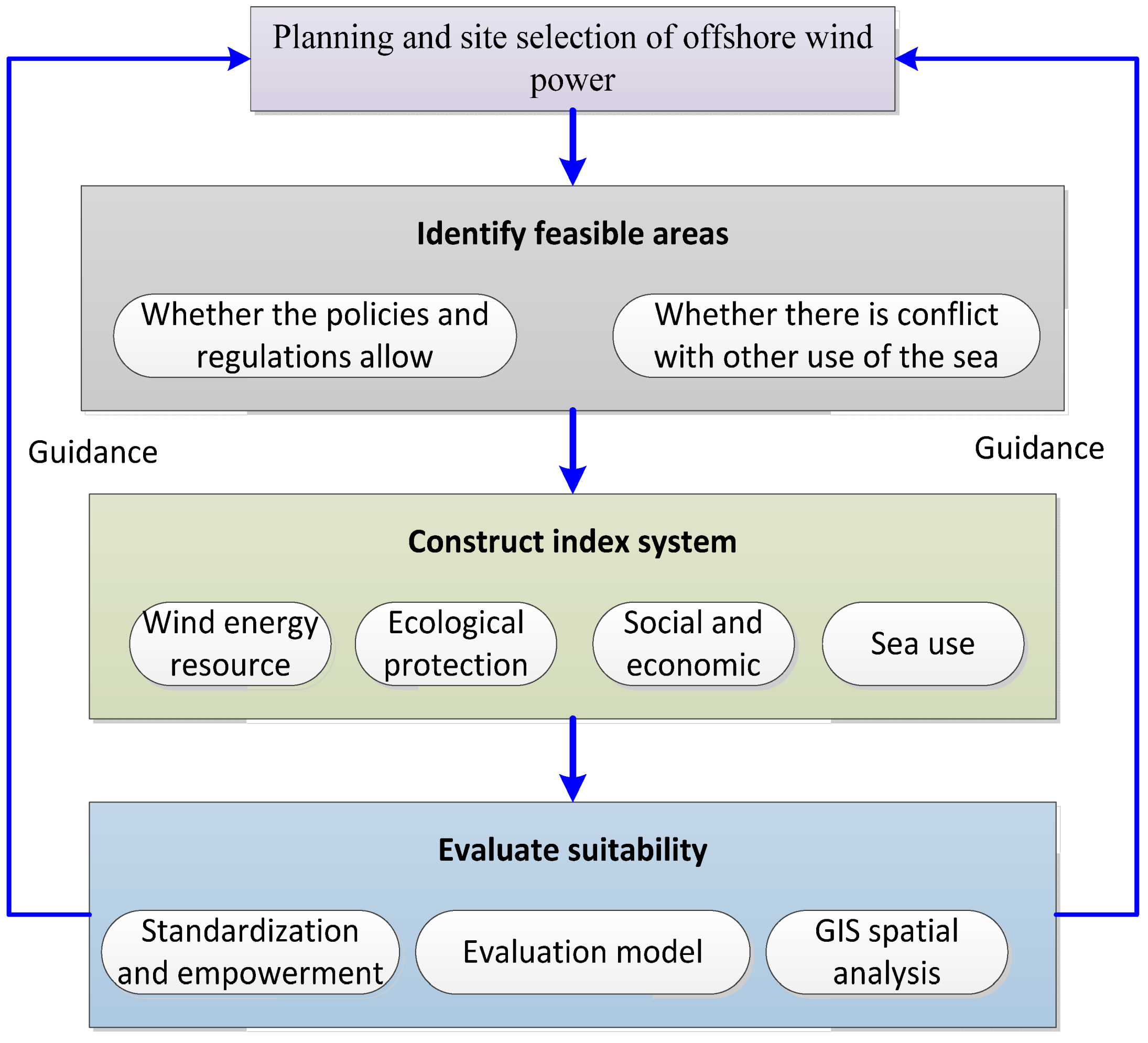
:1. Introduction
2. Summary of the Research
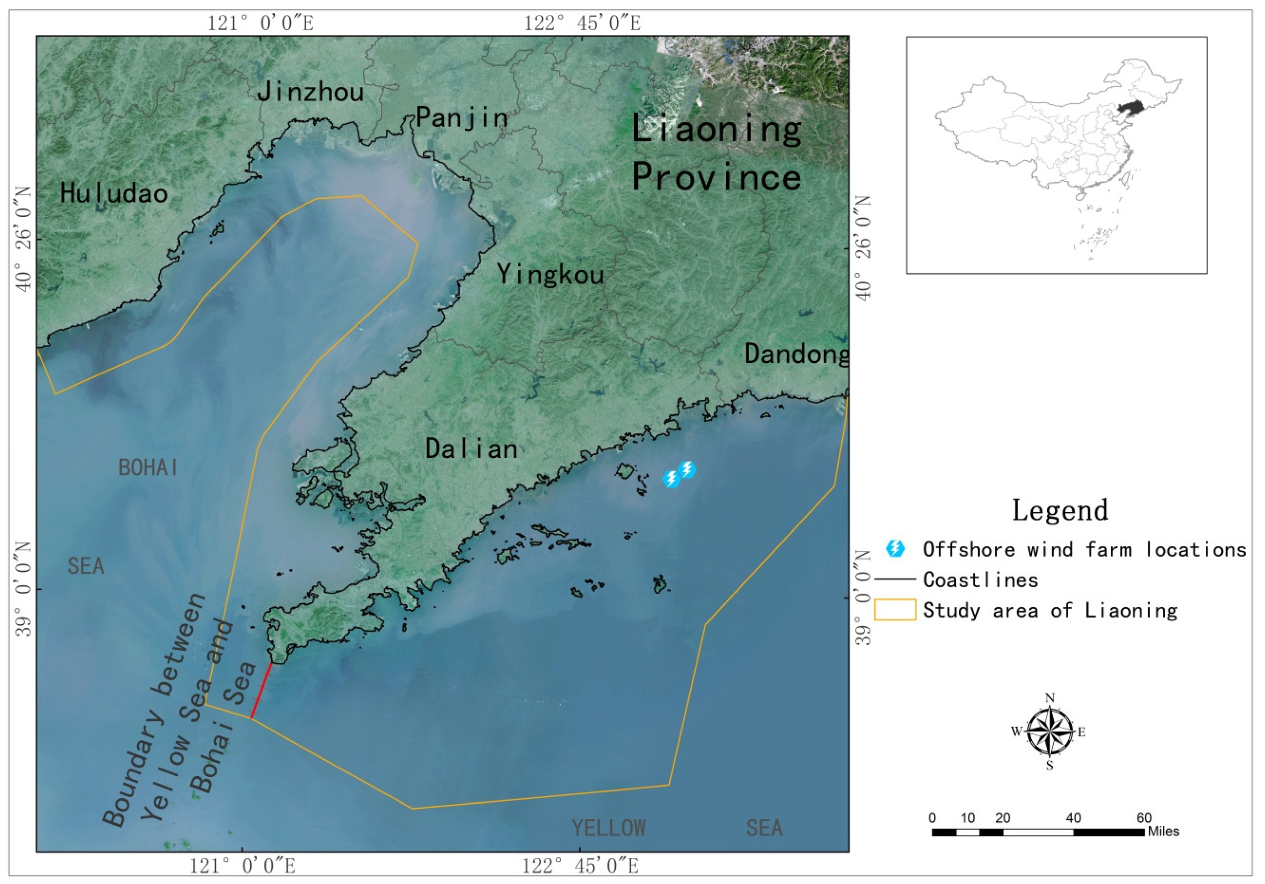
3. Overview of the Study Area
4. Data and Research Methods
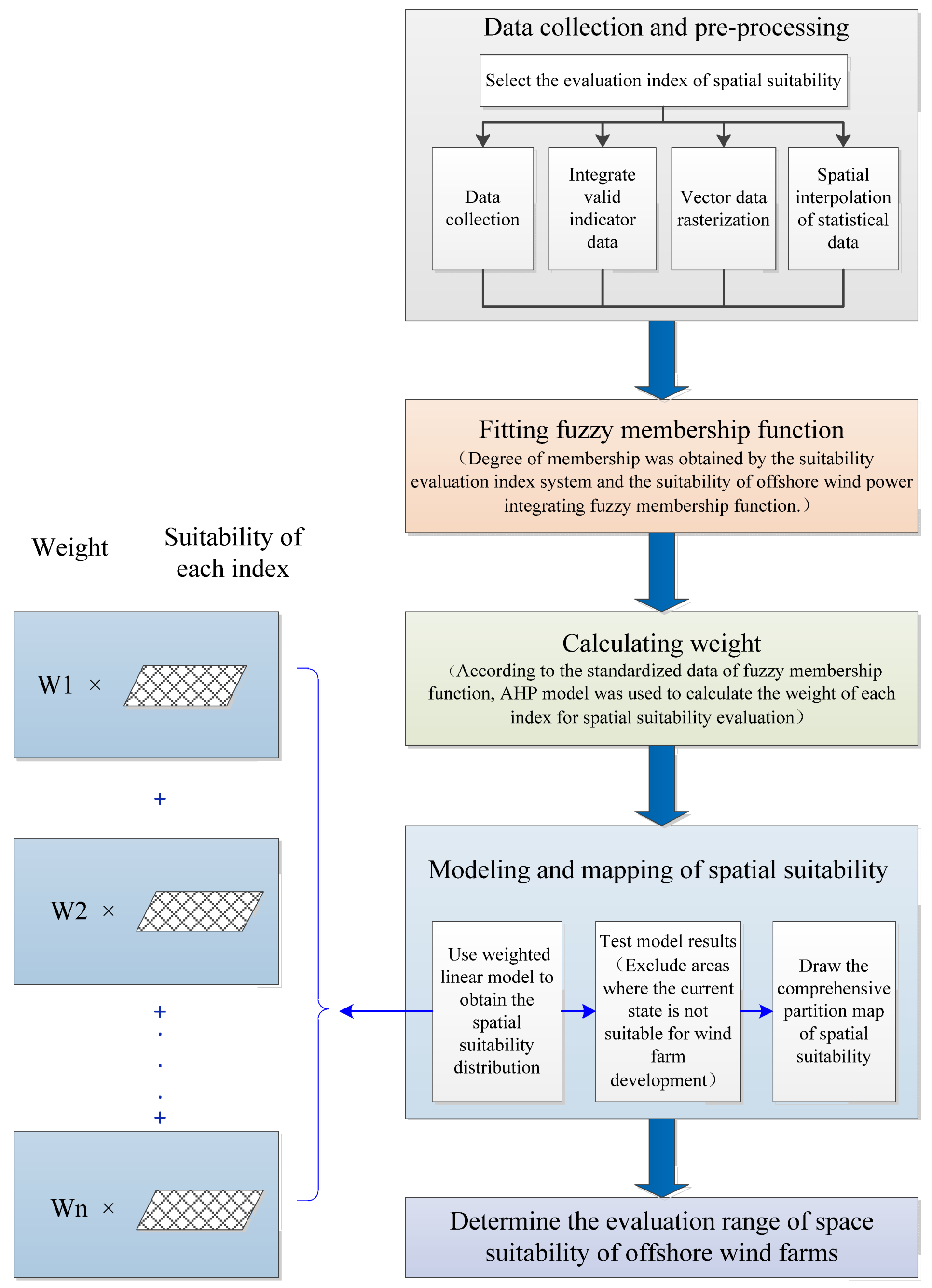
4.1. Research Framework
4.2. Index System and Data Sources

| Index Number | Index | Units | Numerical Range | Data Sources |
|---|---|---|---|---|
| C1 | Wind speed | m/s | 4.2–4.8 | Adopted the wind speed data of Liaoning on August 2018 [47,48,49] |
| C2 | Water depth | m | 10–60 | Water depth data points were interpolated based on data measured by the Chinese National Marine Environmental Monitoring Center in 2005. |
| C3 | Distance from coastlines | km | 10–136 | These data were obtained by remote sensing and site reconnaissance. |
| C4 | Distance from shipping lanes | km | 0–113 | These data were based on the navigational charts [50] |
| C5 | Distance from protected areas and ecological conservation redlines | km | 0–47 | Marine Function Zoning of Liaoning [51] |
| C6 | Distance to the nearest port | km | 0–144 | Marine Function Zoning of Liaoning |
| C7 | Distance from sea use activities with sea area use right certificates | km | 0–62 | Marine Function Zoning of Liaoning and National Sea Area Use Dynamic Supervision System |
4.3. Evaluation Method
4.3.1. Normalization of Indicators
4.3.2. Index Weight Determination
4.3.3. Evaluation Model
5. Results and Analysis
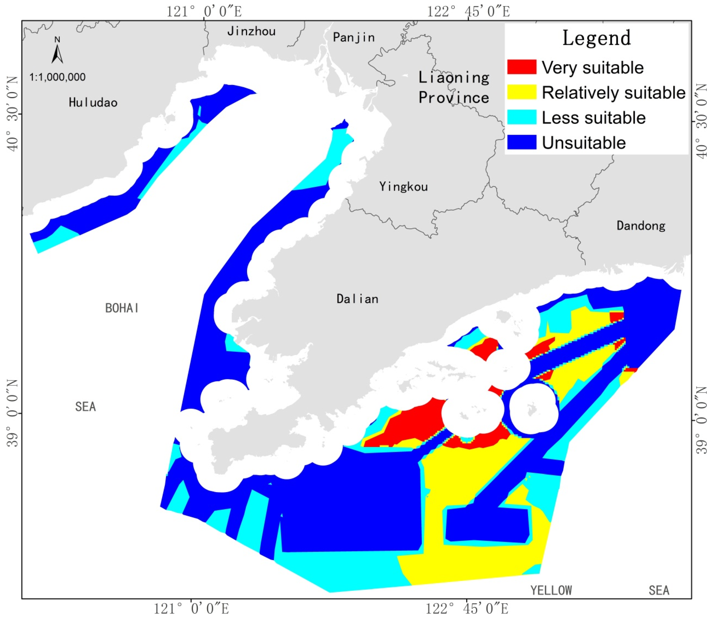
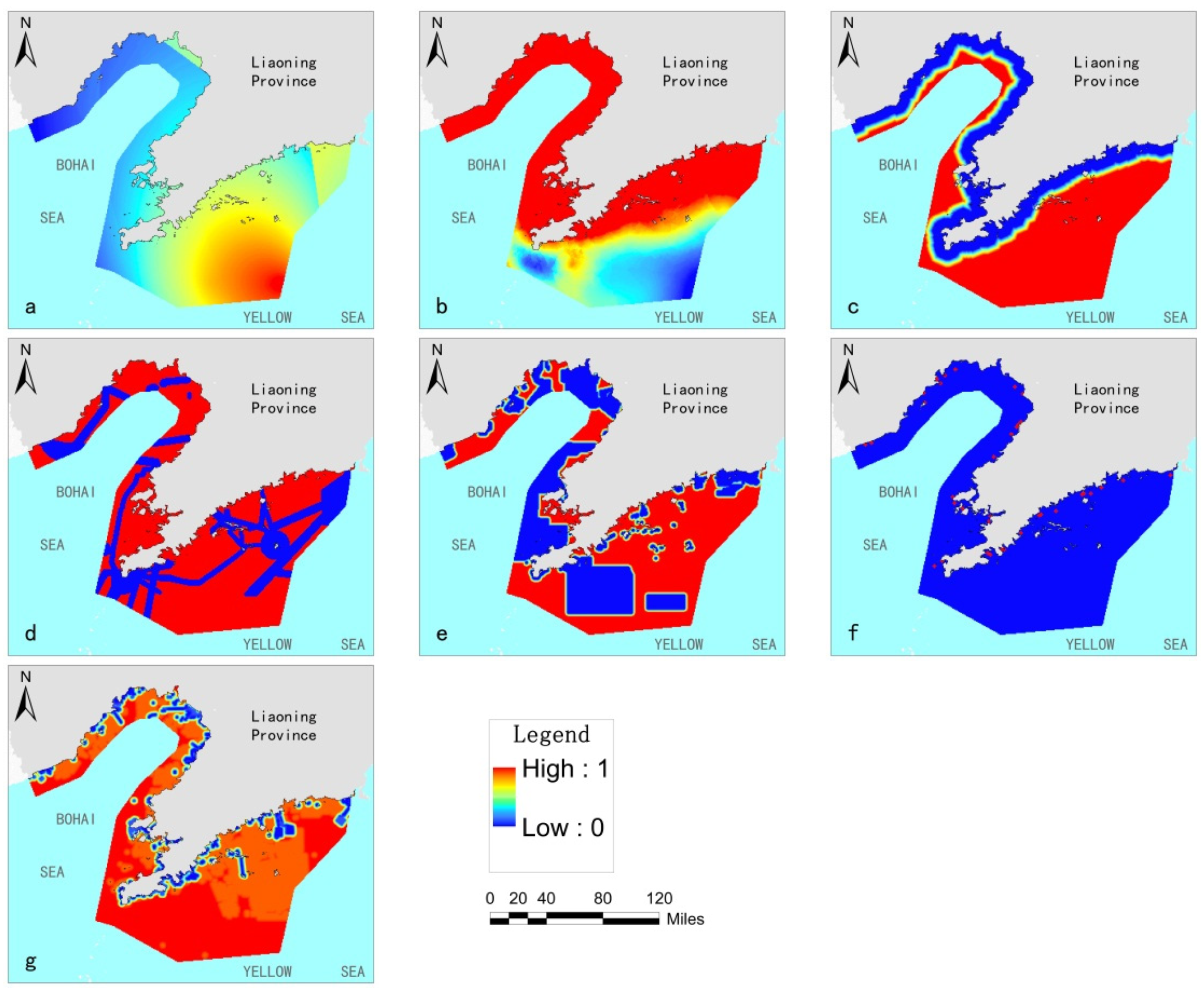
5.1. Analysis of Suitability Evaluation Results
5.2. Analysis of Evaluation Effectiveness
5.3. Development and Mitigation Measures for Offshore Wind Farms in Liaoning
- Give priority to the development of deep-water and areas further offshore for use in wind power development, enhance the value of deep and relatively distant spatial sea resources, and avoid sea use conflicts near shore. Various types of sea use occur in coastal waters. With an increase of the distance from the coastline and in water depth, the types of sea use father offshore mainly include submarine pipelines, military uses, port shipping, and fisheries. By locating wind farms farther away from the shoreline and in deeper water, the impact of offshore wind farms on other sea use types will be reduced.
- Give priority to regional and centralized planning for the planned layout of farm sites with good resource conditions. Small-scale, de-centralized development will lead to a division of resource enrichment areas and a reduction in overall development efficiency. Coordinate farm placement with access to and management of the power grid so that the offshore wind farm locations can be selected in areas with good resource conditions for unified planning and centralized layout. This will reduce the costs of developing wind farms and their environmental impact.
- In new spatial planning efforts, comprehensively consider the feasibility of addressing environmental and technical constraints and identify any areas that are suitable for offshore wind farm development through GIS. When the timing has not yet been determined for offshore wind farm development, priority should be given to areas with minimal environmental and technical constraints so that the zonation and management requirements are clear and compatible with offshore wind farms. Offshore wind farms should be arranged in an orderly fashion on the premise that they will not have an important negative impact on either national defense or maritime transportation safety.
6. Conclusions
Author Contributions
Funding
Institutional Review Board Statement
Informed Consent Statement
Data Availability Statement
Acknowledgments
Conflicts of Interest
References
- Lee, J.; Zhao, F.; Dutton, A.; Backwell, B.; Fleasta, R.; Qiao, L.; Balachandan, N.; Lim, S.; Liang, W.; Clarke, E.; et al. Global Wind Report 2021; Global Wind Energy Council: Brussels, Belgium, 2021. [Google Scholar]
- IRENA (2021), Renewable Capacity Statistics 2021 International Renewable Energy Agency (IRENA), Abu Dhabi. 2021. Available online: https://www.irena.org/-/media/Files/IRENA/Agency/Publication/2021/Apr/IRENA_RE_Capacity_Statistics_2021.pdf (accessed on 27 December 2021).
- IRENA (2020), Renewable Capacity Statistics 2020 International Renewable Energy Agency (IRENA), Abu Dhabi. 2020. Available online: https://www.irena.org/-/media/Files/IRENA/Agency/Publication/2020/Mar/IRENA_RE_Capacity_Statistics_2020.pdf (accessed on 27 December 2021).
- National Energy Administration. The 13th Five-Year Plan for Wind Power Development. November 2016. Available online: http://www.nea.gov.cn/2016-11/29/c_135867633.htm (accessed on 27 December 2021).
- National Development and Reform Commission. Notice on the On-Grid Tariff Policy for Offshore Wind Power. Available online: https://www.ndrc.gov.cn/xxgk/zcfb/tz/201406/t20140619_964151.html?code=&state=123 (accessed on 27 December 2021).
- IRENA (2017), Renewable Capacity Statistics 2017, International Renewable Energy Agency (IRENA), Abu Dhabi. Available online: https://www.irena.org/-/media/Files/IRENA/Agency/Publication/2017/Mar/IRENA_RE_Capacity_Statistics_2017.pdf (accessed on 27 December 2021).
- IRENA (2018), Renewable Capacity Statistics 2018, International Renewable Energy Agency (IRENA), Abu Dhabi. Available online: https://www.irena.org/-/media/Files/IRENA/Agency/Publication/2018/Mar/IRENA_RE_Capacity_Statistics_2018.pdf (accessed on 27 December 2021).
- IRENA (2019), Renewable Capacity Statistics 2019, International Renewable Energy Agency (IRENA), Abu Dhabi. Available online: https://www.irena.org/-/media/Files/IRENA/Agency/Publication/2019/Mar/IRENA_RE_Capacity_Statistics_2019.pdf (accessed on 27 December 2021).
- Action Plan for Peaking Carbon by 2030. Available online: http://www.gov.cn/zhengce/content/2021-10/26/content_5644984.htm (accessed on 27 December 2021).
- Transcript of the Press Conference of the National Energy Administration in the Fourth Quarter of 2021. Available online: http://www.nea.gov.cn/2021-11/08/c_1310298464.htm (accessed on 27 December 2021).
- China Renewable Energy Engineering Institute. China Renewable Energy Development Report; China Water & Power Press: Beijing, China, 2020; pp. 39–40. [Google Scholar]
- National Marine Data Center, National Science & Technology Resource Sharing Service Platform of China. 2021. Available online: http://mds.nmdis.org.cn (accessed on 27 December 2021).
- Guangdong Development and Reform Commission. Guangdong Offshore Wind Power Development Plan (2017–2030). 2018. Available online: http://drc.gd.gov.cn/gkmlpt/content/1/1060/post_1060661.html#876 (accessed on 27 December 2021).
- Zhongnan Engineering Corporation Limited. Shandong Offshore Wind Power Development Plan (2019–2035). 2020. Available online: https://news.bjx.com.cn/html/20200715/1089353.shtml (accessed on 27 December 2021).
- Huadong Engineering Corporation Limited. Liaoning Offshore Wind Farm Project Planning Report; Liaoning Provincial Development and Reform Commission: Shenyang, China, 2021; under review. [Google Scholar]
- National Marine Environmental Monitoring Center. Research on the Utilization and Protection of Sea Areas in the 13th Five-Year Plan for the Development of National Marine Industry; State Oceanic Administration of China: Beijing, China, 2016. [Google Scholar]
- Vasileiou, M.; Loukogeorgaki, E.; Vagiona, D.G. GIS-Based Multi-Criteria Decision Analysis for Site Selection of Hybrid Offshore Wind and Wave Energy Systems in Greece. Renew. Sustain. Energy Rev. 2017, 73, 745–757. [Google Scholar] [CrossRef]
- Mahdy, M.; Bahaj, A.S. Multi Criteria Decision Analysis for Offshore Wind Energy Potential in Egypt. Renew. Energy 2018, 118, 278–289. [Google Scholar] [CrossRef]
- Gavériaux, L.; Laverrière, G.; Wang, T.; Maslov, N.; Claramunt, C. GIS-Based Multi-Criteria Analysis for Offshore Wind Turbine Deployment in Hong Kong. Ann. GIS 2019, 25, 207–218. [Google Scholar] [CrossRef]
- Argin, M.; Yercib, V.; Erdoganc, N.; Kucuksarid, S.; Calie, U. Exploring the Offshore Wind Energy Potential of Turkey Based on Multi-Criteria Site Selection. Energy Strateg. Rev. 2019, 23, 33–46. [Google Scholar] [CrossRef]
- Zhao, Y.J.; Wang, Z.J. Comprehensive Evaluation Method of Offshore Wind Power Development and Utilization Location in Tianjin Coastal Area. Green Technol. 2017, 11, 117–118. [Google Scholar]
- Kaya, T.; Kahraman, C. Multicriteria Decision Making in Energy Planning Using a Modified Fuzzy TOPSIS Methodology. Expert Syst. Appl. 2011, 38, 6577–6585. [Google Scholar] [CrossRef]
- Aragonesbeltran, P.; Chaparrogonzalez, F.; Pastorferrando, J.; Plarubio, A. An AHP (Analytic Hierarchy Process)/ANP (Analytic Network Process)-Based Multi-Criteria Decision Approach for the Selection of Solar-Thermal Power Plant Investment Projects. Energy 2014, 66, 222–238. [Google Scholar] [CrossRef]
- Wiguna, K.A.; Sarno, R.; Ariyani, N.F. Optimization Solar Farm Site Selection Using Multi-Criteria Decision Making Fuzzy AHP and PROMETHEE: Case Study in Bali. In Proceedings of the International Conference on Information and Communication Technology, Surabaya, Indonesia, 12 October 2016; pp. 237–243. [Google Scholar]
- Ziemba, P.; Wątrobski, J.; Ziolo, M.; Karczmarczyk, A. Using the PROSA Method in Offshore Wind Farm Location Problems. Energies 2017, 10, 1755. [Google Scholar] [CrossRef] [Green Version]
- Wu, Y.; Tao, Y.; Zhang, B.; Wang, S.; Xu, C.; Zhou, J. A Decision Framework of Offshore Wind Power Station Site Selection Using a PROMETHEE Method under Intuitionistic Fuzzy Environment: A Case in China. Ocean Coast. Manag. 2019, 10, 1–16. [Google Scholar] [CrossRef]
- Liu, J.Z.; Ma, L.F.; Wang, Q.H.; Fang, F.; Zhu, Y.K. Offshore Wind Power Supports China’s Energy Transition. Strateg. Study CAE 2021, 23, 149–159. [Google Scholar]
- Yao, Z.Y. Research on the Development Status of Offshore Wind Power in China. China Power Enterp. Manag. 2019, 22, 24–28. [Google Scholar]
- Zhao, L. Global Offshore Wind Power Market Outlook 2030. Wind Energy 2021, 10, 40–43. [Google Scholar]
- National Marine Environmental Monitoring Center. Special Research on Land and Space Planning of Liaoning Province (2020–2035)—Research on Marine Land and Space Development and Protection and Land and Sea Overall Planning of Liaoning Province; Ministry of Natural Resources of the People’s Republic of China: Beijing, China, 2021; under review.
- Ma, Y.; Zhu, J.; Gu, G.; Chen, K. Freight Transportation and Economic Growth for Zones: Sustainability and Development Strategy in China. Sustainability 2020, 24, 10450. [Google Scholar] [CrossRef]
- Lin, X.H.; Gao, J.; Liu, B.; Wei, Y.Z. The Development Status of Global Offshore Wind Power Industry and Its Enlightenment to China. Ecol. Econ. 2014, 30, 25–29. [Google Scholar]
- Liu, B.Q.; Xu, M.; Liu, Q. The Main Problems and Countermeasures of Offshore Wind Power Development in China. Mar. Dev. Manag. 2015, 3, 7–12. [Google Scholar]
- Peng, H.B.; Wu, S.S.; Wang, S.; Fang, C.H.; Li, F. Analysis on the Evolution of China’s Offshore Wind Power Development Policy. J. Mar. Dev. Manag. 2016, 6, 72–78. [Google Scholar]
- Opinions of the State Oceanic Administration on Further Regulating the Sea Use Management of Offshore Wind Power. Available online: http://f.mnr.gov.cn/201807/t20180702_1967043.html (accessed on 27 December 2021).
- Tercan, E.; Tapkm, S.; Latinopoulos, D.; Dereli, M.A.; Tsiropoulos, A.; Ak, M.F. A GIS-Based Multi-Criteria Model for Offshore Wind Energy Power Plants Site Selection in Both Sides of the Aegean Sea. Environ. Monti. Assess. 2020, 9, 1–20. [Google Scholar] [CrossRef]
- Vagiona, D.G.; Karanikolas, N.M. A Multi-Criteria Approach to Evaluate Offshore Wind Farms Siting in Greece. Glob. NEST J. 2012, 14, 235–243. [Google Scholar]
- Chaouachi, A.; Covrig, C.F.; Ardelean, M. Multi-Criteria Selection of Offshore Wind Farms: Case Study for the Baltic States. Energy Policy 2017, 103, 179–192. [Google Scholar] [CrossRef]
- Cavazzi, S.; Dutton, A.G. An Offshore Wind Energy Geographic Information System (OWE-GIS) for Assessment of the UK’s Offshore Wind Energy Potential. Renew. Energy 2016, 87, 212–228. [Google Scholar] [CrossRef]
- Wang, S.; Wang, S. Impacts of Wind Energy on Environment: A Review. J. Renew. Sustain. Energy Rev. 2015, 49, 437–443. [Google Scholar] [CrossRef]
- Bailey, H.; Brookes, K.L.; Thompson, P.M. Assessing Environmental Impacts of Offshore Wind Farms: Lessons Learned and Recommendations for the Future. Aquatic Bio. Syst. 2014, 10, 8. [Google Scholar] [CrossRef] [PubMed] [Green Version]
- Snyder, B.; Kaiser, M.J. Ecological and Economic Cost Benefit Analysis of Offshore Wind Energy. J. Renew. Energy 2009, 34, 1567–1578. [Google Scholar] [CrossRef]
- Möller, B. Continuous Spatial Modelling to Analyze Planning and Economic Consequences of Offshore Wind Energy. J. Energy Policy 2011, 39, 511–517. [Google Scholar] [CrossRef]
- Schillings, C.; Wanderer, T.; Cameron, L.; van der Wal, J.T.; Jacquemin, J.; Veum, K. A Decision Support System for Assessing Offshore Wind Energy Potential in the North Sea. J. Energy Policy 2012, 49, 541–551. [Google Scholar] [CrossRef] [Green Version]
- Kim, C.K.; Jang, S.; Kim, T.Y. Site selection for Offshore Wind Farms in the Southwest Coast of South Korea. J. Renew. Energy 2018, 120, 151–162. [Google Scholar] [CrossRef]
- Yue, C.D.; Yang, M.H. Exploring the Potential of Wind Energy for a Coastal State. J. Energy Policy 2009, 37, 3925–3940. [Google Scholar] [CrossRef]
- Ge, Y.; Li, Q.; Dong, W. Global Ocean Temperature and Ocean Wind Dataset (1990–2018). National Tibetan Plateau Data Center. 2019. Available online: https://data.tpdc.ac.cn/en/data/cc45adf0-5eeb-4299-a5f7-af67213015ae/ (accessed on 27 December 2021).
- Cheng, L.; Zhu, J. Benefits of CMIP5 Multi-Model Ensemble in Reconstructing Historical Ocean Subsurface Temperature Vatiation. J. Clim. 2016, 29, 5393–5416. [Google Scholar] [CrossRef]
- Wentz, F.J.; Ricciardulli, L.; Hilburn, K.; Mears, C. How Much More Rain Will Global Warming Bring? Science 2007, 317, 233–235. [Google Scholar] [CrossRef]
- The Navigation Guarantee Department of the Chinese Navy Headquarters. The Navigational Charts; CNPP: Tianjing, China, 2014; pp. 11110–12141.
- Marine Functional Zoning in Liaoning Province. 2012. Available online: http://zrzy.ln.gov.cn/zwgk/ghjh/hygh/201912/t20191220_3693772.html (accessed on 27 December 2021).
- Cradden, L.; Kalogeri, C.; Barrios, I.M.; Galanis, G.; Ingram, D.; Kallos, G. Multi-Criteria Site Selection for Offshore Renewable Energy Platforms. Renew. Energy 2016, 87, 791–806. [Google Scholar] [CrossRef] [Green Version]
- Sourianos, E.; Kyriakou, K.; Hatiris, G.A. GIS-Based Spatial Decision Support System for the Optimum Siting of Offshore Windfarms. Eur. Water 2017, 58, 337–343. [Google Scholar]
- Duan, S.R.; Li, Y.F.; Li, C.Y. Geological Hazard Risk Assessment Based on GIS and Analytical Hierarchy Process in Gande County, Qinghai Province. Miner. Explor. 2021, 12, 453–460. [Google Scholar]
- Deng, X.; Li, J.M.; Zeng, H.J.; Chen, J.Y.; Zhao, J.F. Research on Computation Methods of AHP Weight Vector and Its Applications. Math. Pract. Theory 2012, 42, 93–100. [Google Scholar]
- Malczewski, J. On the Use of Weighted Linear Combination Method in GIS: Common and Best Practice Approaches. Trans. GIS 2000, 4, 5–22. [Google Scholar] [CrossRef]


| Serial Number | Index | Type | Fuzzy Function | q | p |
|---|---|---|---|---|---|
| C1 | Wind speed | Growth | 6.5 m/s | 8 m/s | |
| C2 | Water depth | Decreasing | 60 m | 30 m | |
| C3 | Distance from coastlines | Decreasing | 20 km | 10 km | |
| C4 | Distance from lanes | Growth | 2 km | 3 km | |
| C5 | Distance from protected areas and ecological conservation redlines | Growth | 1 km | 5 km | |
| C6 | Distance from ports | Decreasing | 25 km | 1.5 km | |
| C7 | Distance from sea use activities with sea area use right certificates | Growth | 1 km | 5 km |
| Evaluation Factors | Wind Speed | Water Depth | Distance from Coastlines | Distance from Shipping Lanes | Distance from Protected Areas and Ecological Conservation Redlines | Distance from Ports | Distance from Developed and Currently Used Water Locations |
|---|---|---|---|---|---|---|---|
| Wind speed | 1 | 3 | 1 | 1 | 1 | 3 | 5 |
| Water depth | 1/3 | 1 | 1/3 | 1/3 | 1/3 | 1 | 3 |
| Distance from coastlines | 1 | 3 | 1 | 1 | 1 | 3 | 5 |
| Distance from shipping lanes | 1 | 3 | 1 | 1 | 1 | 3 | 5 |
| Distance from protected areas and ecological conservation redlines | 1 | 3 | 1 | 1 | 1 | 3 | 5 |
| Distance from ports | 1/3 | 1 | 1/3 | 1/3 | 1/3 | 1 | 3 |
| Distance from sea use activities with sea area use right certificates | 1/5 | 1/3 | 1/5 | 1/5 | 1/5 | 1/3 | 1 |
| Serial Number | Index | Weight |
|---|---|---|
| C1 | Wind speed | 0.1805 |
| C2 | Water depth | 0.1169 |
| C3 | Distance from coastlines | 0.1805 |
| C4 | Distance from shipping lanes | 0.1805 |
| C5 | Distance from protected areas and ecological conservation redlines | 0.1805 |
| C6 | Distance from ports | 0.1169 |
| C7 | Distance from sea use activities with sea area use right certificates | 0.0442 |
Publisher’s Note: MDPI stays neutral with regard to jurisdictional claims in published maps and institutional affiliations. |
© 2022 by the authors. Licensee MDPI, Basel, Switzerland. This article is an open access article distributed under the terms and conditions of the Creative Commons Attribution (CC BY) license (https://creativecommons.org/licenses/by/4.0/).
Share and Cite
Huang, J.; Huang, X.; Song, N.; Ma, Y.; Wei, D. Evaluation of the Spatial Suitability of Offshore Wind Farm—A Case Study of the Sea Area of Liaoning Province. Sustainability 2022, 14, 449. https://doi.org/10.3390/su14010449
Huang J, Huang X, Song N, Ma Y, Wei D. Evaluation of the Spatial Suitability of Offshore Wind Farm—A Case Study of the Sea Area of Liaoning Province. Sustainability. 2022; 14(1):449. https://doi.org/10.3390/su14010449
Chicago/Turabian StyleHuang, Jie, Xiaolu Huang, Nanqi Song, Yu Ma, and Dan Wei. 2022. "Evaluation of the Spatial Suitability of Offshore Wind Farm—A Case Study of the Sea Area of Liaoning Province" Sustainability 14, no. 1: 449. https://doi.org/10.3390/su14010449
APA StyleHuang, J., Huang, X., Song, N., Ma, Y., & Wei, D. (2022). Evaluation of the Spatial Suitability of Offshore Wind Farm—A Case Study of the Sea Area of Liaoning Province. Sustainability, 14(1), 449. https://doi.org/10.3390/su14010449