1. Introduction
According to the Faro Convention [
1], in Europe there is a clear and urgent need for emphasizing the value and the potential of cultural heritage as a resource for sustainable growth and quality of life. This is even more crucial in rural areas, which embody outstanding examples of Cultural and Natural Heritage (CNH) [
2]. Rural landscapes cover around 95% of the EU territory [
3], and almost 55% of the EU-28 population lives in rural areas or in towns and villages, while around 44% of European gross added value is created in intermediate and predominantly rural areas [
4]. At the same time, many rural areas suffer from economic, social and environmental problems, leading to rising unemployment, civic disengagement, depopulation and marginalization, which in turn generates environmental degradation or loss of cultural, biological and landscape diversity that also threatens CNH resources [
5]. Therefore, rural areas have great economic and CNH potential that can be exploited in tackling their socio-economic challenges towards a sustainable regeneration of rural communities. While this path has been explored at an international level [
6,
7,
8,
9,
10], this perspective is rather new in the European context, stimulated by the evolving meanings of CNH and its role in a smart, inclusive and sustainable growth [
11] and the overall role of culture as the fourth pillar of sustainable development [
12,
13].
In Europe, the heritage concept has been affected by many changes since its emergence and its expansion in the 19th century [
14], moving from a conservative and object-oriented approach to a value-oriented one [
15]. This change of paradigm has led to the most recent Faro Convention definition, which considers Cultural Heritage as “a group of resources inherited from the past which people identify, independently of ownership, as a reflection and expression of their constantly evolving values, beliefs, knowledge and traditions. It includes all aspects of the environment resulting from the interaction between people and place through time” [
1]. This definition includes all aspects of Cultural Heritage, such as tangible and intangible assets, which are comprised and integrated to form a unique conceptual system. Natural Heritage, which mainly refers to natural features and habitats, geological and physiographical formations and natural sites of value [
16], and has been traditionally considered aside from Cultural Heritage [
15], is also included in this perspective. Therefore, the current European perspective on Cultural and Natural Heritage preservation, restoration and safeguarding implies and encourages a better integration of these three aspects of Cultural Heritage (built and tangible, natural and intangible) within CNH policy and planning measures.
These innovations imply not only a different definition of terms, but also a change in the paradigm of Cultural and Natural Heritage, which leads to new perspectives on the role of CNH in linking and influencing society, economy, politics, ecology and opening new opportunities, especially for rural areas. Indeed, heritage assets and vernacular resources can be seen as valuable roots for economic and environmental growth and regeneration, and a major contributor to social cohesion and civic engagement [
5,
17,
18], especially in rural areas, which are particularly rich in CNH heritage and therefore can be an important factor in the GDP of these rural territories. From this perspective, CNH represents a key driver for sustainable growth and regeneration of rural territories, overcoming the common idea that heritage preservation and sustainable development are antithetical. Instead, heritage preservation and sustainable development have been mobilizing much attention within territorial development policy, and often in conjunction with each other [
19], as the positive role of culture within development strategies and plans is discovered [
20].
Including CNH as a driver for local development strategies also places attention on the role of local communities in the interpretation, valorization, and management of CNH. Local communities are those who define the meanings and the values of the CNH, definingHeritage communities as “people who value specific aspects of cultural heritage which they wish, within the framework of public action, to sustain and transmit to future generations” [
1]. Therefore, CNH is increasingly considered in relation to how people can perceive and define it, and it is recognized as both the engine and catalyst of socio-economic development [
20,
21]. In particular, the way in which people perceive and value the natural environment is one of the most important drivers of change in rural areas [
22] that are working towards inclusive community engagement, heritage ownership and stronger social cohesion, largely contributing to sustainable regeneration of rural territories.
Public participation in regenerative planning processes is therefore crucial to engage local communities in interpreting and realizing the rural heritage value and potential for the sustainable and inclusive growth of their territory. Participatory planning processes aim to involve wide segments of the public in local decision making, relying on citizens’ involvement to improve the quality of decisions, as well as their legitimacy, implementation, and outcomes, while simultaneously generating additional benefits, such as social learning, social capital and empowerment [
23]. However, while participation is increasingly included in territorial, landscape and environmental planning practice and legislation [
24,
25,
26], and co-creation becomes a “must” of most EU funded projects [
27], the implementation of this approach remains rather limited in rural contexts. Participatory planning can be problematic in rural areas, due to the loss of local knowledge and disengagement [
28], as well as due to the geography and the infrastructure of the place, and the relevant “communities of interest” that can be hard to sustain over time [
29]. At the same time, community and stakeholder involvement is crucial for undertaking inclusive and sustainable rural regeneration, because it is able to generate additional benefits not just to the social capital, but also to the natural, built and human capitals of the territory [
30].
Through the recognition of the role of CNH as an important driver for stimulating an economic and social renaissance of rural areas, and the acknowledgment of the challenges in involving local communities in the rural regeneration processes, this paper proposes a methodological framework for undertaking inclusive and participatory planning processes that support rural communities to co-create heritage-led regeneration plans for their territory. This framework, which has been developed within the H2020 RURITAGE project, is called a methodology for Community-based Heritage Management and Planning (CHMP). It aims to transform and guide rural communities towards desired and sustainable futures, where CNH is seen as a resource to preserve, maintain and develop upon, as well as overcome, the barriers that hamper public participation in decision-making processes. Notably, the methodology details the main pillars and stages to undertake fruitful engagement and collaboration among the key local actors, including proponents, stakeholders, local leaders and the whole community, to better integrate their needs, perceptions and views within the development of local regeneration plans, and to strengthen their active role in the implementation of such plans. This framework of actors and interactions represents an arena that takes the form of a Rural Heritage Hub (RHH), which comprises not only people, but also spaces and places that enable the dialogue and foster the engagement.
This paper does not simply aim to present the conceptual approach of the CHMP methodology, but it also provides preliminary results about the effectiveness of this process, presenting the results of the CHMP implementation in six demonstrators across Europe.
To this end,
Section 2 presents and discusses the main features of the proposed conceptual framework, while in
Section 3 we present the material and methods that have been used to assess the CHMP application in six RURITAGE demonstrators.
Section 4 illustrates the results of the CHMP implementation by addressing two specific questions: (i) did the CHMP implementation enable and maintain rural community participation along the entire decision-making process, based on local heritage recognition, ownership and enhancement? (ii) did stakeholders contribute to build and strengthen inclusive and sustainable rural development and regeneration? Lastly,
Section 5 discusses the main results and
Section 6 summarizes the main conclusions of the work.
2. Conceptual Framework
The RURITAGE project recognizes rural areas as powerful laboratories of innovation based on their cultural and natural heritage. Through the identification and recognition of six drivers for sustainable rural regeneration, the so-called Systemic Innovation Areas (SIAs), namely Pilgrimage, Local Food Production, Migration, Arts & Festivals, Resilience and Integrated Landscape Management [
30], RURITAGE goes beyond the more common tourism and food production-based development models [
19,
22], considering also art, festivals and local traditions, as well as resilience and migration as crucial drivers of local regeneration and development.
This paradigm is the basis for the development of the methodology for Community-based Heritage Management and Planning (CHMP), since it builds on the idea that rural communities and stakeholders are made up of a wide range of actors and citizens that should be properly involved in the development of local regeneration plans. The methodology provides an operational programme to co-develop heritage-led regeneration plans in rural areas, based on a sound theoretical background. More in detail, the CHMP methodology foresees a series of activities for effectively co-creating rural regeneration plans based on the valorization and promotion of the local CNH through the establishment of the so-called Rural Heritage Hubs (RHHs). RHHs are social spaces or communities of stakeholders at the local level, embedded in physical spaces where knowledge transfer and sharing takes place.
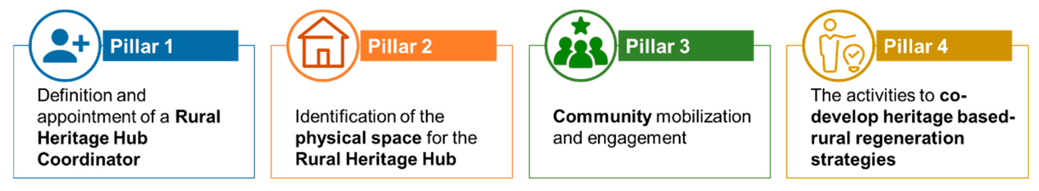
As illustrated in
Figure 1, the whole CHMP methodology is based on four main pillars, which are described in the following sub-sections.
2.1. Definition and Appointment of a RHH Coordinator
One of the main issues in setting up effective participatory processes is to build and develop relationships and sufficient trust among the stakeholders to discuss problems and share ideas and visions for their territory [
31]. Some argue that stakeholder participation may sometimes lead to the aggravation of conflicts rather than to their mitigation or solutions [
31,
32]. In the early stages, communities are often particularly fragile, as the effort of starting new stable structures and cooperation patterns is high. For these reasons, the first step of the process regards the appointment of the role of the ‘RHH Coordinator’, whose role is considered crucial within the CHMP to properly build up an interpersonal trust between the community and the planners, and to boost perceived credibility in the process [
23].
The RHH Coordinator plays a role that is frequently underestimated. They do not act as a mere facilitator of a participatory process, but as a community manager, able to build trust around the overall process, maintain the community and stakeholder engagement and lead the process towards the planned objectives. For this reason, the RHH Coordinator does not act alone but should be supported at a strategic level by the relevant proponent partner overseeing the regeneration process in the rural territory (i.e., municipality, non-governmental organization, parks and geoparks, Local Action Groups, etc.). In this sense, considering the specificities of rural areas, the CHMP includes the involvement of the so-called “local leaders” [
33]. The local leaders can be well-known and respected representatives of local communities who shall be engaged within the RHHs, such as schoolteachers, priests, doctors, farmers, artists, influencers or any other respected and recognized person at the local level that can create trust, curiosity and interest around processes that the RHH may put in place.
2.2. Identification of the Physical Space for the RHH
According to [
34], place attachment supports community social cohesion, organized participation and community development. For this reason, and to enhance and valorize local CNH, the RHH should be located in a building characterized by historical and cultural value, with spaces and facilities that facilitate the undertaking of a variety of activities, depending on the number of participants and the activities themselves. Ideally, in the identification of the RHH, rural territories should apply a circular adaptive reuse as a “restorative, regenerative and a sustainable form of conservation that extends the life of our cherished heritage, stimulate civic pride and responsibility, and preserve cultural values for future generations” [
35].
To foster multiple uses and extend the role of the space beyond the activities related with the co-development of the heritage-led regeneration plan, the RHH is also conceived as a multi-functional space, able to integrate different functions, activities and communities in time and space [
36]. Therefore, the CHMP methodology suggests giving multiple functionalities to the RHH to ensure a community-based management of the space with diverse purposes, further strengthening the sense of ownership and leading to building a stronger and closer community, which is one of the main objectives of the project itself. Some examples of different uses that could be given to these spaces to keep them vibrant and useful in the long run include co-working space, a newspaper library with access to the internet, literature club activities, a book exchange point, a repair café, a second hand market, handcrafts workshops and classes, a wellness spot (e.g., yoga, Pilates or fitness lessons), language courses, dance lessons, movie nights, theatre lessons, a chess club, a business meeting centre, photography workshops or a tourist info point. Setting up regulations governing its use, being transparent and open, defining opening times and sharing an events calendar are important elements to consider in maintaining the RHH as a living space all year round.
2.3. Community Mobilization and Engagement
Within the CHMP methodology, the identification and engagement of relevant stakeholders is led through a multi-stakeholder, inclusive approach which aims to involve a rich variety of key interest groups in the project activities that ensures a wide range of visions and opinions in the discussions, paying special attention to rural vulnerable groups such as migrants and disabled people. The RURITAGE methodology for stakeholder identification and engagement is developed based on experiences from past EU-funded projects and “I-CEE” methodology [
37]. This involves four stages: Identifying, Connecting, Engaging, and Enabling.
The Identifying stage includes building a stakeholder typology to better understand which stakeholders need to be engaged and how to do so in an effective manner. There are four functional areas from which the key interest groups should be identified. The “Policy” group concerns, for instance, regional and local governing bodies and institutions with responsibility in territorial development or planning, urbanism, management of cultural and natural heritage sites, tourism, education or culture. In this sense, local administrations are a crucial actor to be involved in the process, whenever they are not the same initiator of the process, which is often the case. The “Public/User” group involves the local community, civil society organizations, schools and other education and training centers, local action groups, etc. The “Research” group comprises universities and/or research institutes engaged in research related to cultural and natural heritage management, among other fields. Lastly, the “Industry/Services/Investors” group involves public and private investors, key service providers and representatives of key value chains according to local specificities and interests, such as tourism, cultural and creative industries, food, arts and crafts, etc.
The Connecting stage aims at ensuring optimal connection with stakeholders by recruiting stakeholders for the RHHs and increasing awareness of the project’s scope, objectives, methods and timescales. In relation to the Engaging stage, its core objective is maintaining stakeholder awareness and interest within the RHHs to support the co-development, co-implementation and co-monitoring of the heritage-led regeneration plans. To overcome the limitations in community participation in rural contexts [
38], RURITAGE proposes to optimize the recruitment process through a set of defined steps: identification of potential participants, setting the invitation criteria, inviting participants and enrolment and confirmation. The last stage, Enabling, entails creative communication and dissemination designed to maximize the potential for take-up and adoption of the co-developed heritage-led regeneration plans. Furthermore, the RURITAGE methodology also involves the development of a stakeholder “living” database, at both the organizational and individual level, that allows the further analysis of stakeholder engagement characteristics and needs in the rural areas prior to and during RHHs’ activities, based on their potential relevance and interest in the various SIAs.
2.4. The Activities to Co-Develop Heritage Based-Rural Regeneration Plans
Once the RHH has been established both in terms of space and community, the RHH coordinator is responsible for starting the process of co-development with the community and the stakeholders. To implement this process, the RURITAGE project developed a series of workshops to support the RHH in creating a shared vision for regeneration, collecting and understanding main needs and challenges, tailoring the good practices coming from other case studies in EU [
30] or developing new ones and defining timelines, funding, roles and shared responsibilities to implement the regeneration plan in the RHH territory.
Table 1 summarizes the aims of the workshops along with tools and methods to be used and expected outcomes. It also provides external references that can be consulted.
The process starts with the launch event, where the RHH coordinator, with the support of the local team, presents the RHHs to the local community, both in terms of the new use of the space, but also explaining the participatory and community-based process that will follow. The launch event is intended to be an open public event, co-created with local stakeholders and addressing the whole community. Within RURITAGE, the co-development process was kicked off by inviting stakeholders to play the RURITANIA serious game. RURITANIA was designed to build a common vision for the future of the territories and to raise awareness of the importance of collaboration among stakeholders. It supports the development of a shared vision of the future of the territory. Building on the results of the serious game, RHH coordinators organize the so-called RURITAGE participatory workshop. The participatory workshop represents the core activity of the co-development phase, where good practices and model actions coming from other RURITAGE Role Models (see Egusquiza et al. 2021) are presented to the local communities. Local stakeholders and communities then have the oppurtunity to discuss these actions and practices, to select the most relevant ones and to start tailoring and adapting them to their territories. These actions encompass the six RURITAGE SIAs and represent the foundation of the heritage-led regeneration plans to be co-developed. Moreover, local stakeholders and communities are also invited to propose diverse actions that can be discussed during the participatory workshop and that can be included in the local heritage-led regeneration plan. The actions proposed during the participatory workshops are then assessed and further detailed during the Business Model Canvas Workshop. Through an adapted version of the traditional business model canvas, this workshop facilitates the completion of innovative business models and understand the feasibility of the proposed actions that will be further detailed and defined in the final round-table with local stakeholders. To enhance local collaboration and to define public–private or public–public partnerships with local stakeholders, round-tables are crucial. They have been designed to formalize activities, timelines, budget and responsibilities of the various actions that will comprise the local heritage-led regeneration plan. After the round-table events, the RHH coordinator can draft the heritage-led regeneration plan and, eventually, seek public or private investment to finance actions not already covered by the initiators or by local stakeholders. This takes place in the so-called investors’ event. To finalize the process, an open public event at the RHH should be organized to launch the implementation phase of the process and to further involve local communities and citizens who are among the main target of the heritage-led regeneration plan.
Even though the workflow is designed as if the outputs of one workshop will be the main inputs of the following one, RURITAGE workshops can also be implemented as stand-alone events, taking into account the development stage of the rural territory at the moment of implementation.
3. Material and Methods
A case-study approach has been applied to test the CHMP methodology and to explore the role of the RHHs as enablers of community engagement in rural areas. The CHMP methodology has been implemented in 19 territories across Europe and Latin America, as part of the RURITAGE consortium. The case-study method enables the researcher to explore practical life events, behavioral processes and organizational procedures. Case studies enable the use of multiple sources of evidence, by collecting data within the context of the subject matter enabling the integration and comparison of the collected data and information [
41,
42].
Within the scope of this research, we present the results of the six demonstrators—among 19 case studies included in the RURTAGE project—that established their RHHs and implemented the whole co-development stage, towards the definition of their heritage-led regeneration plans [
39]. Two different analyses were applied in parallel throughout the research, to describe the role of the RHH place and the engagement of RHH communities in the co-development phase of the heritage-led rural regeneration plans. The former is aimed at investigating how the physical place has been turned into the location to enable and maintain the participation of rural communities in local decision making, based on local heritage recognition, ownership and enhancement. The latter is conceived to assess the actual role of stakeholders and communities and their contribution to building and strengthening inclusive and sustainable rural development and regeneration in the six RURITAGE demonstrators. These two methods of analysis are further described in
Section 3.2 and
Section 3.3.
3.1. The Six RURITAGE Demonstrators
The six RURITAGE demonstrators are located in six different countries that vary in terms of territory, heritage and communities involved and that represent diverse types of rural areas.
As stated by [
43], “because of national differences in the characteristics that distinguish urban from rural areas”, there is no shared definition of rural areas. Often, they are defined in opposition to the areas considered to be urban. But also, among non-urban areas there are different kinds or degrees of rurality, from fairly populated areas with extensive cropland to less densely settled areas of sparse vegetation.
What people consider to be a rural area is ultimately a subjective determination, which depends on social and cultural context as much as settlement patterns and landscape. Recognizing that subjectivity, no definition can be said or proved to be uniquely correct; rather, a definition can only be judged to be more or less appropriate for the use to which it will be put. Indeed, rurality is likely to have several conceptual dimensions, the definition of what is rural being rooted in a sense of place [
44].
Over the years, definitions of what is rural have emerged in both domestic and international settings. Differences in administrative structures and in the make-up of economies have to be acknowledged, along with the variation in social and environmental conditions that are present even within countries [
44].
The OECD [
45] developed and implemented a definition of rural which is built upon the administrative structure of a country, considering population density, the size of urban centers within a region and remoteness (i.e., the driving time needed to reach a highly populated center). This sorting yielded four types of regions (i.e., administrative level NUTS3): Predominantly Urban, Intermediate, Predominantly Rural Close to a City and Predominantly Rural Remote. In terms of geography, it is obvious that both between and within countries the physical size of administrative and/or political units varies considerably, and that the aggregation of the results are NUTS3 level does not reflect the high variability of territories within the same region.
The Degree of Urbanization (DEGURBA+), developed by the JRC within the GHSL project (
https://ghsl.jrc.ec.europa.eu/ (accessed on 23 December 2020)) by adopting a spatial unit (i.e., grid cell of 1 km
2), overcomes the issue of the different definition of administrative boundaries and allows the consideration of the presence of sparse settlement, reflecting the idea that urban areas are those that have the most people and that are most densely settled, while rural areas are more sparsely populated and settled. The latest update of the classification is based on the 2011 population grid and the 2016 Local Administrative Units (LAU) boundaries. Based on the share of local population (2011) living in urban clusters and in urban centers, it classifies Local Administrative Units (LAU or communes) into three types of area: Cities (densely populated areas), Towns and suburbs (intermediate density areas) and Rural areas (thinly populated areas).
Having in mind the different degree of urbanization/realization within the same region, the considered case studies have been selected within all four of the OECD typologies, thus guaranteeing the further replicability of the proposed approach. Within the regions, the degree of urbanization has been considered in order to select territories classified as towns, suburbs and rural areas according to the Degree of Urbanization.
The most relevant characteristics of the selected case studies, including OECD classification, GDP per capita of the area compared with the national standard and the map of the degree of urbanization are summarized in
Table 2, while here below additional information have been provided for each demonstrator:
The Karavanke/Karawanken UNESCO Global Geopark (ARGE) is a cross-border geopark which includes 14 municipalities altogether, covering a territory across Austria and Slovenia. The RHH is placed in the village of Tichoja/Tihoja, which is part of the municipality of Sittersdorf, Austria and has a population of around 2000 inhabitants. Within RURITAGE, Karavanke/Karawanken UNESCO Global Geopark focuses on the restoration and further improvement of an existing pilgrimage site and route, along with the development and further renewal of hiking tours, which are provided by the geopark staff.
Since Magma UNESCO Global Geopark (MAGMA) was established as a geopark in 2008, it has been actively working in the field of community engagement and valorization of cultural and natural heritage through tourism activities and educational programs. The RHH is located in the city center of Egersund municipality in South-West Norway. There are about 15,000 people living in Egersund, and about 32,000 people living in the geopark area, which consists of five municipalities. Local food production is by far the main priority in the Magma UNESCO Global Geopark strategy.
The Geo-Naturpark Bergstraße-Odenwald UNESCO Global Geopark (GEO-N) is located in South-West Germany, covering the states of Hesse, Bavaria and Baden-Württemberg, which include 102 municipalities. The RHH is located in the headquarters of the geopark in Lorsch municipality. Within RURITAGE, Geo-Naturpark Bergstraße-Odenwald UNESCO Global Geopark focuses on supporting the integration of migrants and related territorial development through the support of cultural and natural heritage related training and activities.
The village of Negova is situated in the municipality of Gornia Radgona (NEGOVA) in northeast Slovenia, with a population of approximately 8500 people. The RHH is located at Negova Castle. Inside the Castle and its buildings, as well as outside in the courtyard, several events take place throughout the year, e.g., festivals, exhibitions, concerts, performances, workshops, literature readings, projections, presentations and other meetings. Kultprotour, the touristic association linked to the Municipality of Gornja Radgona, is in charge of managing the Castle and, together with Kibla - an artists association, are developing actions aimed at increasing the role of Negova Castle as an important cultural RHH in the area, and improving and supporting local rural regeneration through cultural events and festivals.
Appignano del Tronto (CoApp) is a village with about 1700 inhabitants, located in the hilly territory of the south of Marche Region in the Tronto River basin. The RHH is located in a former nursery school. Involved in the Italian seismic event of 2016, CoApp mainly works on increasing the resilience of the community, aimed at supporting community resilience not only in terms of natural disasters, but also in a wider sense, including economic and social resilience to depopulation and economic crises.
The area of the Izmir (IZM) demonstrator includes Bergama, Dikili and Kinik district municipalities. The RHH is located in Yukaribey Village, which has around 1000 inhabitants and is part of the Bergama municipality. The Izmir demonstrator mainly focuses on the promotion of an integrated landscape management, aimed at increasing the accessibility of the pilot areas and working on sustainable mobility and territorial branding.
3.2. RHH Place as Enabler of Community Engagement
To investigate the influence of a place such as the RHH for enabling rural communities, we conducted interviews with each RHH coordinator of the six demonstrators. The interviewees were asked to answer 12 questions, to better understand the physical characteristics of the RHHs, their former use, activities they currently host as well as the local identity and heritage value for the community. Notably, the topics investigated through the interview are the following:
Location: it encompasses the municipality, region and country where the case study is located, to highlight the geographical diversity of each demonstrator;
Building age: this data is relevant for stressing the historical features of the RHH in terms of maintenance but also cultural identity;
Former use of the RHH: in case it has been altered during its lifetime to host more contemporary uses or because the old ones disappeared. This feature complements the information regarding the history of the place;
Building renovation: this information has been requested to know the level of renovation of the RHH (especially if compared with the building age) as well as if the renovation was incurred in relation to the RHH establishment;
Building size/rooms available: clarifying the extent of the internal spaces available in the RHH and the availability of spaces for hosting current and future activities;
Outdoor space: describing the type of open spaces (if available) that characterize the RHH and where activities can potentially take place;
Accessibility–location: describing the level of RHH’s accessibility in relation to the territorial scale, which is crucial for facilitating diversified uses of the RHH;
Accessibility–opening hours: describing the accessibility of the RHH in terms of its opening and management, which is crucial for making the RHH a vibrant and frequented space;
Local identity and heritage value: clarifying if, to whom and why the RHH represents a landmark place in the area, giving an idea of the cultural and identity value of the place;
Building use/main activity: describing the main activities led within the RHH, stressing the vitality of the place;
Other uses/activities (multi-functionality): describing other activities that can utilize the RHH’s spaces during the week or the year, giving an idea of the multi-functionality of the RHH;
Digital infrastructures: describing the digital facilities present in the RHH that can support the different activities that may be hosted in the RHH and may also represent a service that may be lacking in the area, stimulating more frequent use of the RHH.
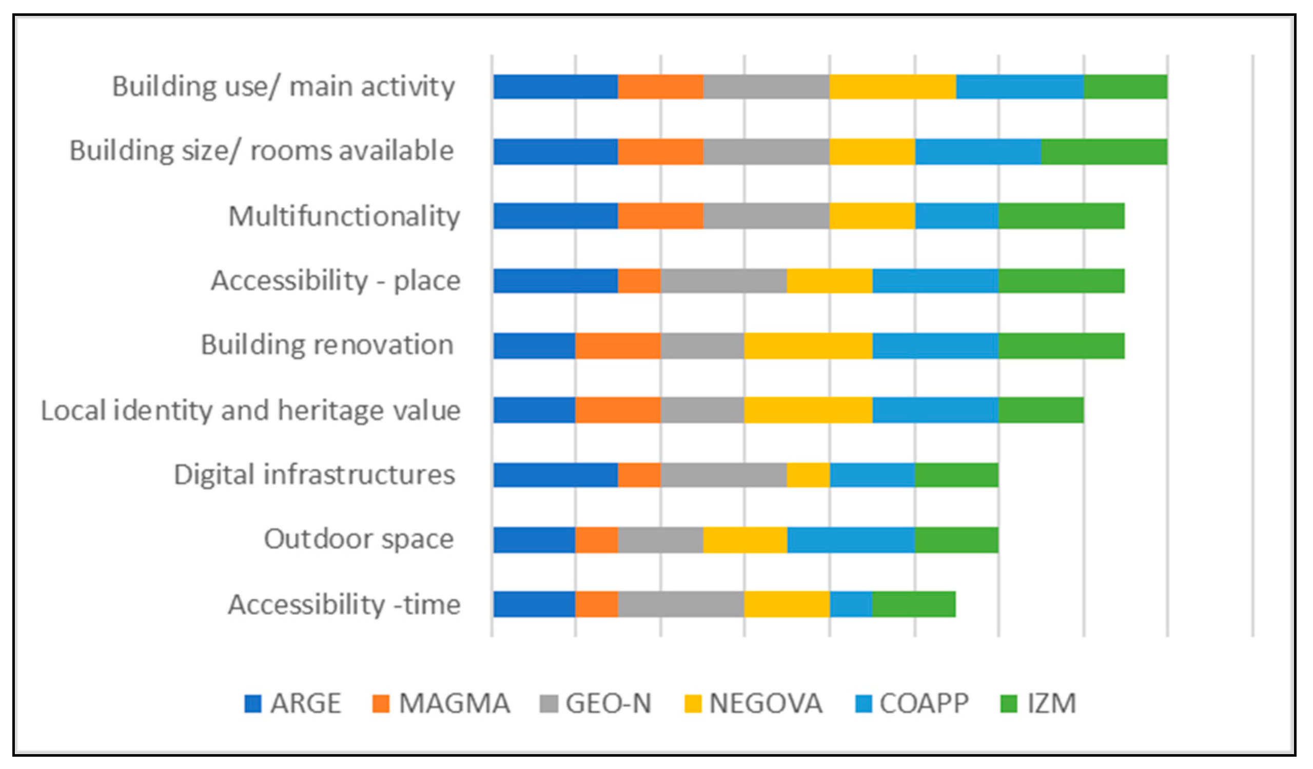
Multiple choices were available for answering questions from 2 to 7, while open answers were possible for the other questions. Location, building age and former use (topics 1–3) are context explanatory, i.e., have been mainly collected to highlight more general differences of the six demonstrators, while the other topics have been considered as crucial in relation to the effectiveness of the co-development activities run within the RHHs. Therefore, the interview was complemented by one more question addressed to the RHH coordinators who were asked to express how they value the relevance of the characteristics covered by questions 4–12 of the RHH, on a scale from one (not relevant) to three (very relevant) in relation to the stakeholders’ and community engagement process.
3.3. CHMP Activities for Community Engagement
In order to assess if the CHMP is enabling and maintaining stakeholder collaboration to develop shared and inclusive regeneration plans, two types of surveys were conducted. On the one hand, RHH communities were analyzed in terms of stakeholder participation and satisfaction throughout the different RHH activities. Stakeholder participation was monitored in all demonstrators through workshop evaluation reports, including efforts to ensure gender balance from an early stage. With regard to the level of satisfaction of stakeholders participating in the workshops, this was measured through a combination of four relevant factors that were aggregated for each of the workshops: (i) confidence with general aims of the project; (ii) perception of relevance of the project to the territory; (iii) perception of relevance of involvement in the development or strengthening of innovative plans for promotion of cultural and natural heritage; (iv) perception of role in the RHH. Respondents rated each of these factors on a scale from “very much” to “insufficient”, while “no answer” indicated a lack of response. Respondents’ answers were collected through a questionnaire that was distributed during or after each of the activities organized within the RHH, where a total of 347 answers were received by all demonstrators in all activities. On the other hand, the process of evaluating whether stakeholders successfully contributed to building and strengthening inclusive and sustainable rural development and regeneration, involved the analysis of (i) type of stakeholders engaged, (ii) number of voluntary partnerships formalized; (iii) perceptions of the RHH’s coordinators regarding the relevance of the type of stakeholders engaged and their overall involvement in both RHH activities and formalizing the partnerships. The type of stakeholders participating in RHH activities were collected through the same workshop evaluation reports used to collect the number of participants in RHH activities, whereas the number of voluntary partnerships formalized was collected separately from their regeneration plans. Qualitative data relating to the perception of RHH’s coordinators was also collected, through an excel table, after all activities were organized and some relevant quotes are reported in the results section below.
4. Results
4.1. The RHHs: The Places
The six demonstrators have set their RHH in very diverse locations and types of buildings with different infrastructures and services available. In this section, we will first present the places (RHH) identified by the demonstrators and then we will show the results of the RHH characteristics assessment given by the RHH coordinator, in order to investigate to what extent the physical spaces have contributed to create a sense of place in the six demonstrators, and, in turn, to enable stakeholder participation and civic engagement. The replies to the full questionnaire have been added in
Appendix A.
- 1.
Location
Three out of six RHHs are located in the historical centre of the towns of Egersund (NO), Lorsh (DE) and Appignano del Tronto (IT). Within the Karawanken/Karavanke Georpark, the Hub is located out from the Sittersdorf village (AT), the Negova Castle (SI) is located in the immediate surroundings of the Negova village but 13 km from the town of Gornja Radgona, while the one of Gediz-Bakircay Basins is located in the Bergama district, within the metropolitan area of Izmir (TK).
- 2.
Building Age and former use
Four out of six RHHs were built before 1945. The most recent ones, in Appignano del Tronto and Bergama, were built after the Second World War, between 1945 and 1970. They have been recently renovated in the framework of the RURITAGE project, as they were formerly unused schools, respectively a nursery school in Appignano del Tronto and a secondary school in Bergama.
- 3.
Building use/Main activity
Three out of six demonstrators have chosen their own premises to establish their RHH, therefore combining their daily activities with the RURITAGE activities (e.g., training, community engagement and cultural events). NEGOVA’s RHH is located within the castle, therefore combining the tourist activities (i.e., tourist office and guided tours) with the RURITAGE activities. ARGE, MAGMA and Geo-N included the RHH within their Geopark premises, while the other two demonstrators, CoApp and IZM, decided to establish the RHH in unused buildings, substantially renovating them in the framework of the project, with an aim towards giving them back to the local communities and applying a circular reuse approach.
- 4.
Building size/rooms available
The six RHHs vary greatly in terms of building size and number of rooms available. The largest RHH is the Negova castle, consisting of almost 3000 sqm of which 90% is in use. The RHH in IZM counts 170 square meters and consists of four rooms. With 54 square meters, the CoApp RHH can be considered the smallest one, although this RHH has additional space provided by a theatre of 200 square meters that can accommodate approximately 100 people. This RHH consists of an open space of about 50 square meters, without architectural barriers that make it accessible to all, and with modular furniture to support a wide range of events and to be flexible to stakeholder needs. The three demonstrators lead by Geoparks decided to host the RHH at their Geopark premises. The RHH in Sittersdorf hosts the offices of the ARGE Geopark and it is a former primary school built before 1945 and renovated in the second half of the 1990s. It has approximately 600 square meters organized into 22 rooms. The Geo-N RHH is a three-story building with five rooms for each floor, and a total size of about 350 square meters. The same choice has been made by Magma Geopark. Located in a former dairy, the Magma Geopark RHH has about 170 square meters for offices. Additional space for meetings is provided by the nearby school for adults.
- 5.
Multifunctionality
All the RHHs are equipped to host meetings and conferences, four out of six are info points for tourists, and a half of them also serve as education and training centers. Cultural activities such as cultural labs and expositions are organized in three out of six RHHs, while two RHHs can host recreational activities such as sports events and hobbies. Negova castle is also widely used for ceremonies, while the CoApp RHH will become a focal point for people who need a place for working or studying in the area.
- 6.
Accessibility–place
When it comes to accessibility, five out of six RHHs are easily accessible by all people in the demonstrator area, while Negova castle is the only one less accessible due to the distance from the town of Gornja Radgona and the lack of public transport reaching the castle. Nevertheless, according to the RHH coordinator, the local population recognizes the value and potential of the castle for the further development of the area, serving as a location where the local community can gather and organize schools and other celebrations.
- 7.
Building renovation
Both the RHH in CoApp and IZM are managed by local authorities and initiators and are responsible for the regeneration process in those areas that invested in the renovation of the buildings in the framework of the RURITAGE project, becoming new places where the community starts meeting again. As for NEGOVA, the castle has been subject to several renovations during its lifetime. Moreover, the castle is currently not fully open, as an entire wing needs further renovations to make it visitable and usable. This is in keeping with the aims of Kultprotur to increase the identity of the Castle as a cultural meeting point. As for the other three RHHs, they have been located within the Geoparks main premises and only Geo-N lightly renovated their place to accommodate RURITAGE activities. These works consisted mainly of painting and re-arranging offices to secure a large room on the second floor which is now being used as a meeting room to organize small events and workshops.
- 8.
Local identity and heritage value
In the cases of ARGE, CoApp and IZM, the RHHs are former schools that were attended by locals. These places are linked with childhood memories, and embed great value in terms of local identity, recognized by their communities as a whole. The RHH in MAGMA hosted the town’s former dairy in the past, therefore it is a symbol of local identity for the rural community and provides a link to the farming history of the town. The RHH in Geo-N and NEGOVA are heritage buildings under monumental protection, which represent important pieces of the local history and identity.
- 9.
Digital infrastructures
All the RHHs are equipped with free WiFi for users, with the exception of Negova castle. The RHHs in ARGE and IZM are also equipped with computers which are used for training and courses.
- 10.
Outdoor space
All of the RHHs have some kind of outdoor space, either a garden as in ARGE and IZM, or a public space next to the RHH building, or both in the case of Negova castle.
- 11.
Accessibility–time
The opening days and hours vary greatly across the six demonstrators, although four out of six are open to the public all day upon request. This RHH characteristic has been evaluated as very relevant only by Geo-N.
When it comes to assessing the relevance of the different characteristics of the RHHs, as shown in
Figure 2, RHH coordinators agreed that the building size, rooms available and the buildings main use were the most relevant features in the facilitation of the stakeholders and community engagement process. Next, assessed as very relevant by half of the demonstrators and fairly relevant by others, the following characteristics were listed: building renovation (where this occurred) and the physical accessibility of the RHH in terms of localization and the multi-functionality of the RHH.
All RHH coordinators agreed that it is crucial to keep the RHH pursuits alive outside of the workshops and relevant co-development activities developed in RURITAGE, either running their main and core activities (i.e., GeoParks main offices or Kultprotur’s touristic related activities) or setting up a shared regulatory protocol for co-use of the space, together with local stakeholders and the community (i.e., CoApp and IZM). Local identity and heritage values followed next, considered as highly relevant by two out of six demonstrators and fairly relevant by the others. All the RHHs embed a value for the community, either as a symbol for local identity or as a cultural heritage asset, and all RHH coordinators recognized that this was either relevant or very relevant during the engagement and co-development phase. There was no general agreement on digital infrastructures and outdoor space. RURITAGE, RHH coordinators evaluated the inclusion of digital infrastructures within the RHH as very relevant or fairly relevant, mostly referring to the provision of fast internet connection. On the outdoor spaces, only CoApp evaluated this as very relevant, while the majority of the other demonstrators assessed it as “relevant”. As shown in
Figure 2, the least relevant feature is the RHH accessibility in terms of opening hours and time.
4.2. The RHH: The Communities
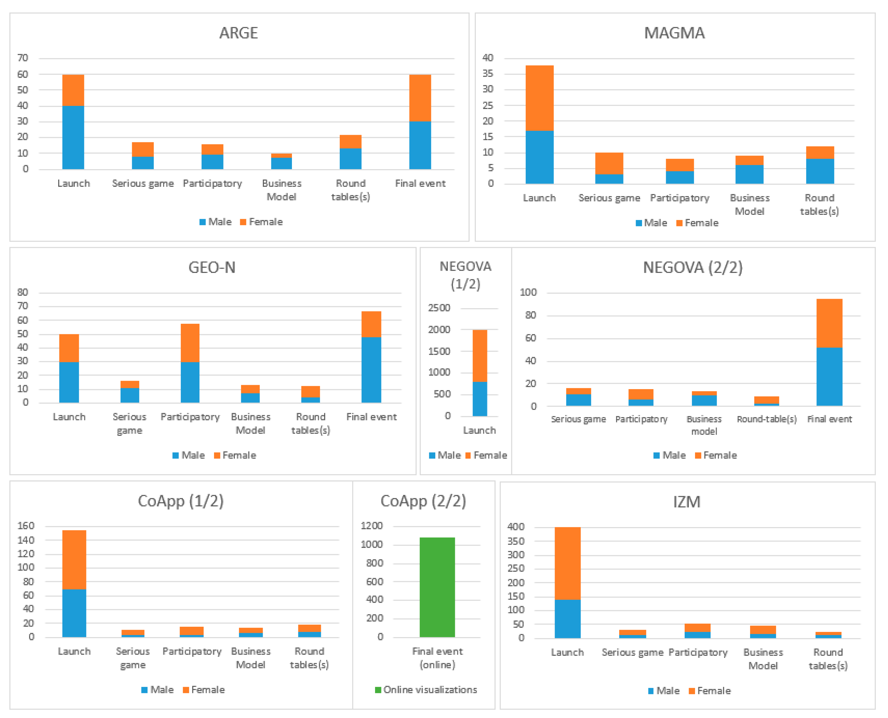
Following the guidelines defined in the CHMP,
Figure 3 summarizes the overall number of stakeholders that attended the various workshops during the co-development phase, according to their gender.
Gender balance was among the main requirement of the RURITAGE methodology and for this reason gender data has been reported in this context. Generally, the participation was well-balanced with some cases of higher female participation (e.g., NEGOVA, CoApp, IZM) and demonstrators with higher male participation (ARGE and Geo-N). It is important to highlight that participation of stakeholders was expected to be higher in the Launch and Final events as these were aimed at engaging a larger audience to communicate and disseminate the project aims and outcomes in general, and the regeneration actions in particular. In addition, and due to the current COVID-19 pandemic crisis, MAGMA and IZM have postponed their Final event until their local sanitary restrictions allow them to be organized in a face-to-face format. In ARGE, participation of stakeholders was fairly steady throughout the process, with the exceptions of larger attendance at the Launch and Final events. The number of participants varied depending on the aim of the workshops, counting for more than 180 participants in total (42% females and 58% males). The MAGMA demonstrator also managed to maintain a consistent attendance of stakeholders during the process, where more than 70 participants attended RHH events (52% females and 48% males). In the case of Geo-N, stakeholder participation remained steady during the process with the exception of the participatory workshop, which experienced a peak in engagement, with more than 200 participants overall (40% females and 60% males). In NEGOVA, the level of stakeholder engagement was very stable from one activity to another, engaging the wide community for the launch event and counting for more than 2000 participants in total (59% females and 41% males). In line with the other demonstrators, CoApp also achieved a steady involvement of stakeholders throughout the process, with the exception of the Launch and Final event where the participation was much higher: participants involved in the RHH have been more than 200 overall along with 1000 online visualizations for the final event (57% females and 43% males). The IZM demonstrator maintained a similar attendance rate throughout the activities, with more than 450 representatives among citizens and stakeholders (64% females and 36% males).
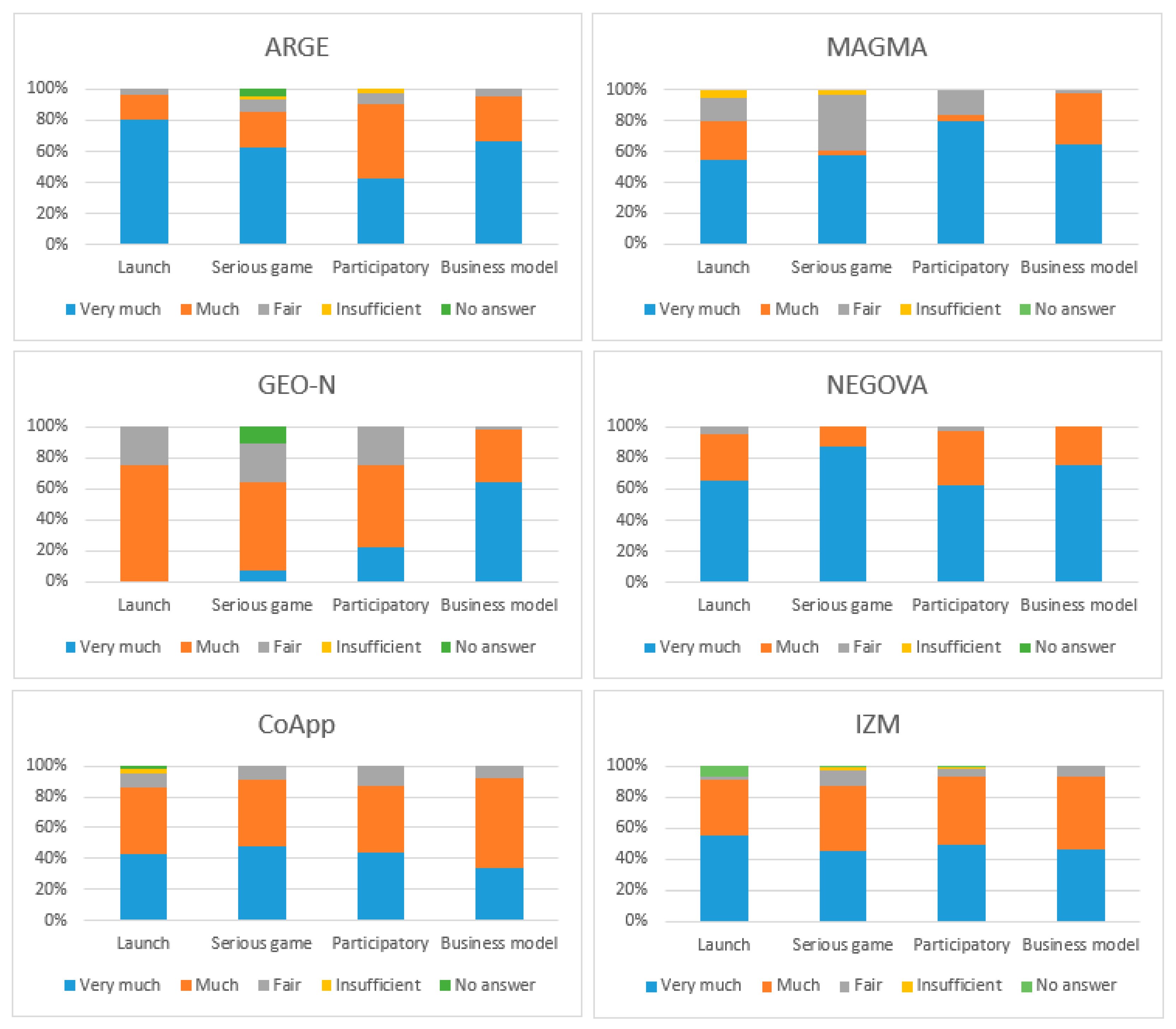
Concerning stakeholder satisfaction (
Figure 4), an overall rating of “very high” to “high” was recorded throughout the CHMP implementation from the first to the last activity. In this context, the analysis looked at the overall participation and level of satisfaction from the viewpoint of stakeholders, but also looked at the final results achieved through the co-development phase in terms of stakeholder contribution to the heritage-led regeneration plans. All demonstrators managed to finalize their local heritage-led regeneration plans before February 2020, engaging many stakeholders to take part in the follow-up implementation phase of the plan. This is reflected in the various public–public and public–private partnerships that have been activated and that will maintain the collaboration with the stakeholders’ active for the entire implementation phase. Specifically, the ARGE demonstrators managed to involve mayors and other municipality representatives of the involved territory, tourism and cultural associations, citizens, researchers, teachers and students, graphic designers, local food providers and restaurants and an archaeological pilgrimage museum and formalized eight voluntary partnerships to deliver a total of five regeneration actions. The RHH coordinator highlighted the importance of engaging local stakeholders as they “contributed with many good ideas” and “supported the process towards territorial regeneration”. In MAGMA, the co-development phase engaged mayors, politicians, local food producers, teachers and students, partners in food development projects, adventure and activity partners of the Magma Geopark, farmers, hospitality representatives, tourism offices and museum representatives. Eight voluntary partnerships have been established for four regeneration actions. The partnerships were formed with local authorities of nearby municipalities, the region, a tourism office and local companies. These, however, have not been established without their own challenges, as they faced some “problems to activate them” and the need has been identified to involve additional relevant stakeholders such as tourist organizations and activity providers to ensure an inclusive approach. In Geo-N, a total of twelve partnerships were formalized for nine regeneration actions, with stakeholders such as a mountain bike club, member communities of Geo-N, on-site guides and rangers, UNESCO World Heritage Site Messel Pit, information centres, a municipality, the historical mining association and art associations. Despite the appropriateness of the range of stakeholders involved, the RHH coordinator pointed out that “the successful implementation of the planned activities is dependent on stakeholder’s experiences, involvement and commitment”. In the NEGOVA demonstrator, the NEGOVA Mayor and other municipalities’ representatives, local development agencies, farmers, citizens, craftsmen and artists, cultural associations, representatives of the agro-tourism sector, local food companies, representatives from schools and universities, student organizations, tourism organizations and museum representatives have been involved in the RHH activities. Nine partnerships were agreed for five regeneration actions with a municipality, an NGO, a wine producer, a zoo, tourism associations, a local development agency and an art association. The RHH coordinator claimed that, despite the delay in implementing some of the actions due to COVID-19 restrictions, they “managed to engage the most competent people in the region for it”. In CoApp, twenty-nine voluntary partnerships were signed for a total of eleven regeneration actions related to the SIAs of landscape, local food, resilience, arts and festivals, pilgrimage and migration, with stakeholders such as geology and vulcanology institutes, regional development departments and agencies, national federations of engineers, the regional register of geology, event organizers, agri-food providers and restaurants, agricultural associations, etc. In this case, it was claimed by the RHH coordinator that “the relevance of the stakeholders, especially those with scientific knowledge on Resilience, is crucial in the co-development of the CoApp heritage-led regeneration plan”. seventeen formal partnerships were established for nine regeneration actions. The type of stakeholders involved included several universities, institutes and public education centres, a municipality and other public authorities, a tourism cooperative, the Chamber of geological engineers, a bio-economy cooperative, arts and culture associations, NGOs and an agricultural technology developer.


 ,
, 


 Urban Center;
  Dense and semi-dense urban cluster (town);
  Suburban cells (suburb);
  Rural cluster (villages);
  Low density rural grid cells (dispersed rural area)/Very low density rural gird cells (mostly uninhabited area) (https://ghsl.jrc.ec.europa.eu/visualisation.php (accessed on 6 January 2021)).


