Article

Managing the Historical Agricultural Landscape in the Sicilian Anthropocene Context. The Landscape of the Valley of the Temples as a Time Capsule

by
Angela Alessandra Badami
Department of Architecture, University of Palermo, 90128 Palermo, Italy
Sustainability 2021, 13(8), 4480; https://doi.org/10.3390/su13084480
Submission received: 23 March 2021 / Revised: 12 April 2021 / Accepted: 14 April 2021 / Published: 16 April 2021

Abstract

:
The debate over whether we are entering the Anthropocene Epoch focuses on the unequal consumption of the Earth system’s resources at the expense of nature’s regenerative abilities. To find a new point of balance with nature, it is useful to look back in time to understand how the so-called “Great Acceleration”—the surge in the consumption of the planet’s resources—hastened the arrival of the Anthropocene. Some particular places—for various reasons—survived the Great Acceleration and, as time capsules, have preserved more or less intact some landscape features that have disappeared elsewhere. How can we enhance these living archives that have come down to us? Through the analysis of the case study of the Valley of the Temples in Agrigento (Sicily, Italy), the article presents several initiatives that have tried to answer this question. For example, the pre-Anthropocene landscape of the Valley of the Temples has preserved rare specimens of some plant species from which living gene banks have been built for the propagation of species, such as the Living Museum of the Almond Tree. In addition, the Kolymbethra, an ancient example of a Mediterranean garden, has been brought back to life revealing finds related to Greek and Arab cultivation and irrigation systems. The research perspectives opened by the “disappeared landscapes” show that the knowledge of the historical landscape, in particular the mechanisms behind its resilience, is indispensable for countering the unsustainable voracity of the Anthropocene and rediscover a renewed synergy between humankind and nature.

1. Introduction

The debate about the consequences of entering the Anthropocene Epoch [1] is at the centre of the reflections of many researchers who have dedicated themselves to analysing the dynamics of humankind’s use and consumption of resources at the expense of nature’s regenerative abilities, adopting lifestyles that have long proved unsustainable. The landscapes of the Anthropocene are the product of the humankind’s predatory attitude towards the environment [2] which, especially since the Great Acceleration [3], has broken the ecosystem’s balance with nature and will eventually overwhelm the thresholds of the planet’s limits, beyond which unforeseeable chain reactions and potentially catastrophic scenarios will likely occur [4].
As Barbera [5] states, it is possible to find answers to the questions of the Anthropocene by looking to the landscape. The analysis of human–landscape interactions in Anthropocene landscapes is an essential interpretative key for better understanding the evolution of our current environment and can provide useful information on the phenomena that gave rise to the Anthropocene. In this context, agriculture is at the centre of human interference in natural cycles; therefore, profound reforms in agriculture and food systems [6] will need to be achieved in the coming years if we want to live within the boundaries of the planet, acting within what Rockström defines as a “safe operating space for humanity” [4].
Finding a point of balance with nature does not necessarily mean returning to a pre-disturbance stage, but rather finding new ecosystem balances [7]. The study of traditional agricultural systems [8], the subject of disciplines such as landscape archaeology and historical ecology, is particularly useful in the search for principles upon which to establish new human–environment balances [9,10]. It might also be useful to look back to the past to understand how the Great Acceleration gave a boost to the Anthropocene. Evaluating the signs of our domination is already the beginning of change and, in this sense, reading the “vanished landscapes” can help us start this process.
This article describes one of the complex and multi-specific landscapes still surviving in Italy, recorded in the National Register of Historical Rural Landscapes [11]. Some landscapes, in fact, characterised by a fine-grained polycultural mosaic, constitute living archives of exceptional value for the conservation of biodiversity. Among these, just to mention the best known, there are the “Terraced and irrigated chestnut groves and vegetable gardens in Alta Valle Sturia” (Liguria, Northern Italy); the “Landscape mosaic of Montalbano” (Tuscany, Central Italy); the “Polycultures of Loretello” (Marche, Central Italy); the “Mixed hill cultures of the lower Irpinia”, the “Terraced orchard-gardens of the hills of Naples” (Campania, Southern Italy); the “Polyculture on the slopes of Mt. Etna” and the “Mixed orchards of the Temples Valley” (Sicily, Southern Italy) [12].
The latter is an exceptional pre-Anthropocene landscape, that is, a case in which a particular regime of constraints has safeguarded a wide territorial environment, preventing its transformation precisely at the start of the period of the Great Acceleration.
The Valley of the Temples in Agrigento (Sicily, Italy) is an archaeological area subject to landscape constraints since the mid-1960s and which extends over an area of more than 1400 hectares. This area, removed from the transformation processes by these constraints, has remained marginalised from the general evolution of the local area. Thus, in this space, traces of dormant landscapes that have disappeared elsewhere have been preserved as real “reserves of history” which are an important point of reference for evaluating the effects of the Anthropocene. The environments that have been preserved allow both to bring back to life animal and plant species that are rare elsewhere, and to revive artisanal and pre-industrial agricultural production systems together with their internal eco-sustainability.
The case analysed makes it possible to critically rethink consolidated development paradigms and to search for new ways of using and consuming the territory’s resources in terms of contents, values and potential. The landscape of the Valley has been enhanced as a natural and cultural ecosystem through a series of initiatives that constitute good practices in land management. The establishment of the Living Museum of the Almond Tree (a genetic bank for the conservation of the intraspecific biodiversity of the species), the restoration of the Kolymbethra Garden (an agricultural area that had been forgotten for over 50 years and, like a message in a bottle or a time capsule, survived through the years of the Great Acceleration in a state of apparent death) and other initiatives carried out in the Valley of the Temples, with the help of agricultural techniques which evolved over the centuries for the cultivation of this specific territory and which we have inherited from the knowledge of the local elderly farmers, have awakened the agricultural landscape from a long sleep.
Thanks to the extraordinary resilience of nature, supported by the historical explorations of ‘placed environmental knowledge’ [13], it has been possible to save rare plant species that enrich the biodiversity of the landscape from extinction. Through the analysis and comparison of the biodiversity of past and present landscapes, in the case in question as elsewhere in similar situations, specific sites are, effectively, archives that provide valuable information from the past that we must learn how to implement and update for a virtuous combination of human environmental transformation and sustainable ecological models of wise use of the territory.

2. Levels of Awareness of the Ecological Footprint of Humankind in the Anthropocene

The intense changes that humanity has imposed, and continues to impose with exponential speed, on the Earth system are pushing us to search for new models of interpretation of the reality that surrounds us and for different ways of using the planet’s resources.
Climate change, famine and migration, pollution are the by-products of these changes that have now taken on an epochal dimension [14]. In this regard, Crutzen and Stoermer’s [1] studies evaluating of the impact of human-induced transformations on global ecology are well known. In his article “Geology of Mankind” [15], Crutzen highlighted how the human species has become a geological force in the sense that the effects of its activities are comparable to those of natural processes, a thesis that has recently been confirmed and supported by others [16]. In view of these processes, Crutzen put forward the proposal to integrate the current geological epoch, the Holocene, with a new era which he suggested calling “Anthropocene”, that is, a geological age dominated by humans. Currently, the Anthropocene Working Group—a group of experts appointed by the International Subcommittee on Quaternary Stratigraphy of the International Union of Geological Sciences—has been working since 2009 to gather scientific evidence in order to formally ratify the Anthropocene as an epoch within the geological time scale [17].
The studies by Steffen, Crutzen and McNeill, starting from the postulate that the industrial era (1800–1945) marked the first phase of the Anthropocene, identify a second phase marked by what is called the “Great Acceleration”, that is, a rapid and pervasive change in human–environment relations that occurred after the end of the Second World War. To measure the phenomena of global change, the authors considered the following indicators: population, total real GDP, direct foreign investment, the damming of rivers, water use, fertiliser consumption, urban population, paper consumption, McDonald’s restaurants, transport (motor vehicles), communication (telephones), international tourism [3]. All indicators recorded a dramatic surge in values starting from the 1950s.
A decade later, studies carried out by McNeill and Engelke [16] have reported the planet’s resource consumption data since the Great Acceleration, figures that have increased ten-fold in just over half a century. Thus, an awareness has emerged that the consumption dynamics of the Anthropocene have definitively transformed the resources of nature into the limits of development.
The limits to Growth were announced in 1972 by the Club of Rome [18]. The group of environmental and Earth system scholars led by Rockström and Steffen added, in 2009, the “limits of the planet”. Exceeding the thresholds could also affect mutually related parameters and trigger additive consequences, non-linear systemic feedbacks and unpredictable chain reactions [5].
The Great Acceleration cannot, and must not, last much longer. From this awareness—according to the interpretation of McNeill and Engelke [16]—began the third phase of the Anthropocene, around 2015, a turning point that has shaken our consciences towards the sustainable management of the planet’s resources. We can trace the beginnings of this turning point to the 1960s, when environmentalism was born and then later, in the 1980s, when rising temperatures confirmed global warming as a reality.
In the third phase of the Anthropocene, it is universally recognised that human activities influence the structures and functioning of the Earth system as a whole (a vision that opposes the searching for solutions to environmental problems on a local or sectoral scale). Despite the general sharing of this dangerous drift of the current development model, state governments still do not prove themselves sufficiently committed to adopting measures to reduce, mitigate or offset the effects [19,20]. Rockström’s studies highlight that it is very difficult to re-establish “a safe operating space” [21,22,23] for human activities due to the fact that prevailing economic and political paradigms do not pay adequate attention to environmental issues [4].
As Barbera has observed [5], due to the harmful effects caused by the Great Acceleration which had transformed nature from a resource to a limit, the sudden leap forward in human activities in the second half of the twentieth century led to many limits being surpassed, altering the planet’s bio-geophysical processes and ecosystem relations. Faced with the complexity of the problem, Barbera indicates that we must seek solutions through an integrated multidisciplinary approach, hoping for the necessary convergence of scientific and humanistic knowledge, and address the issue in global and systemic terms, i.e., at the scale of the entire planet and referring to all its inhabitants (humans, plants, animals). In the systemic vision, says Barbera, the landscape is the set of characteristics of a territory, a meeting place between nature and history, an ecosystem capable of producing negative entropy and restoring order in the dissipative disorder of the Anthropocene.

3. Managing Anthropocene Landscapes

The increase in resource consumption during the Great Acceleration caused a progressive increase in intensive agriculture, industrialisation and urbanisation which transformed natural landscapes by changing the topography, vegetation cover, physical and chemical properties of the soil and water balances, thus inducing large changes in sediment and nutrient retention [24].
The analysis of human–nature interactions in Anthropocene landscapes is an essential interpretative key to better understand the evolution of our current environment [25]. In this context, agriculture is at the centre of human interference in natural cycles (phosphorus, nitrogen, water, etc.); it is therefore necessary to change agri–food systems in the coming years if we want to live within the boundaries of the planet [4].
Mick Lennon [7] warns that it is not possible to manage Anthropocene landscapes by returning degraded ecosystems to a pre-disturbance reference point [16]. The climatic, geological and ecological environments of ecosystems have profoundly changed in the Anthropocene. He therefore proposes the concept of “new ecosystems”, that is, the composition of configurations of non-historical species that arise due to the environmental change of the Anthropocene, a self-evolutionary response of the biosphere to human influence [7].
Since species follow the mechanisms of the theory of evolution, we could extend the concept to agriculture, land cultivation techniques, land uses, production and resource consumption patterns; it will be necessary to select from the past which of these have proven to be the best in terms of sustainable development and review them to update them in new configurations.
The management of the agricultural landscape in its Anthropocene transition must also be considered, as Barbera [5] observes, on the basis of the multiple benefits it provides to humankind. The author therefore proposes to define the notion of landscape not in the sense of a set of interacting ecosystems, but in the sense of cultural landscape, that is, as a combined work of nature and human beings. The landscape, therefore, concerns not only the physical, chemical and biological aspects of the biosphere but also the culture of the populations, their needs—material and immaterial—meanings, symbols, artistic expressions, etc.

4. Materials and Methods

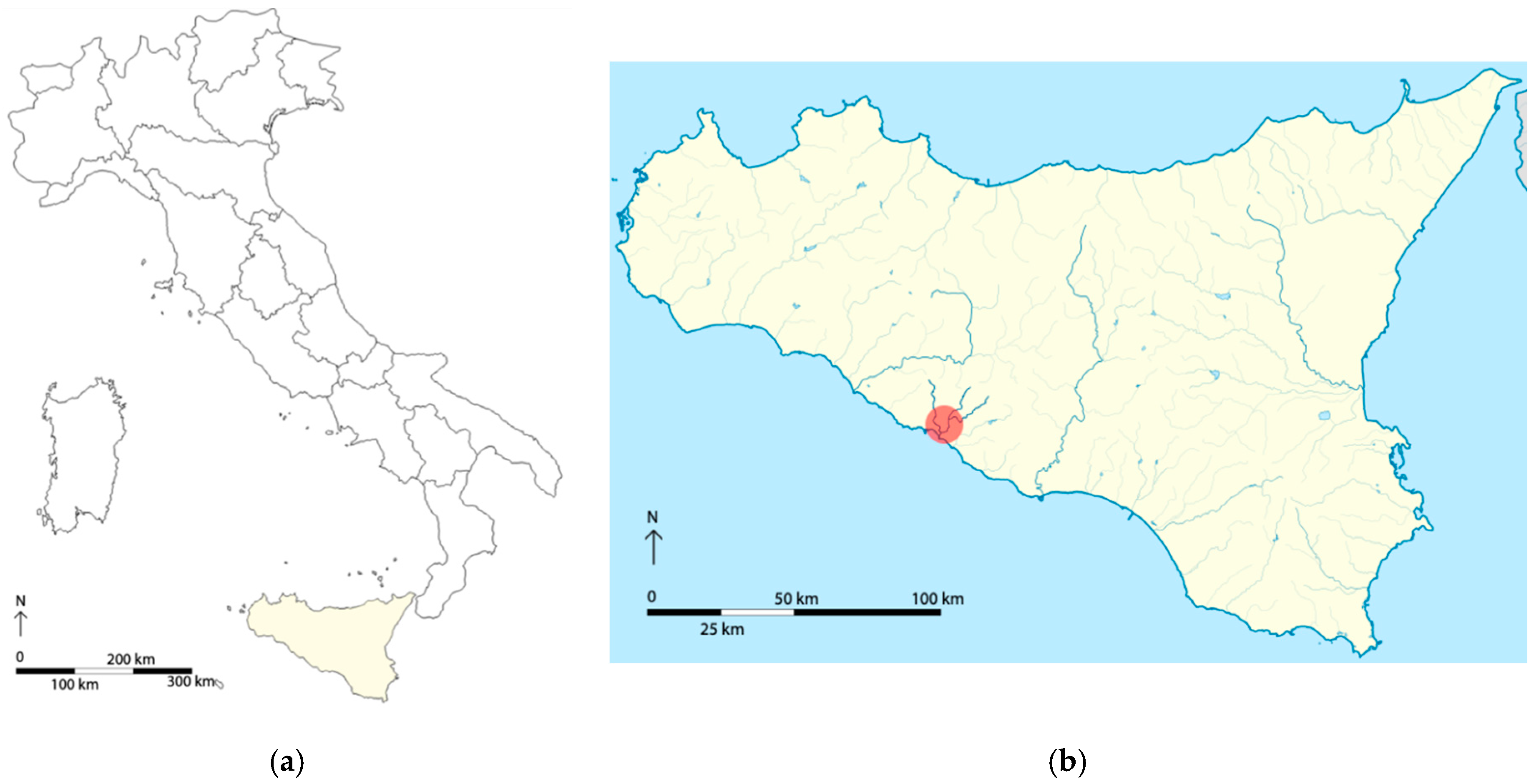
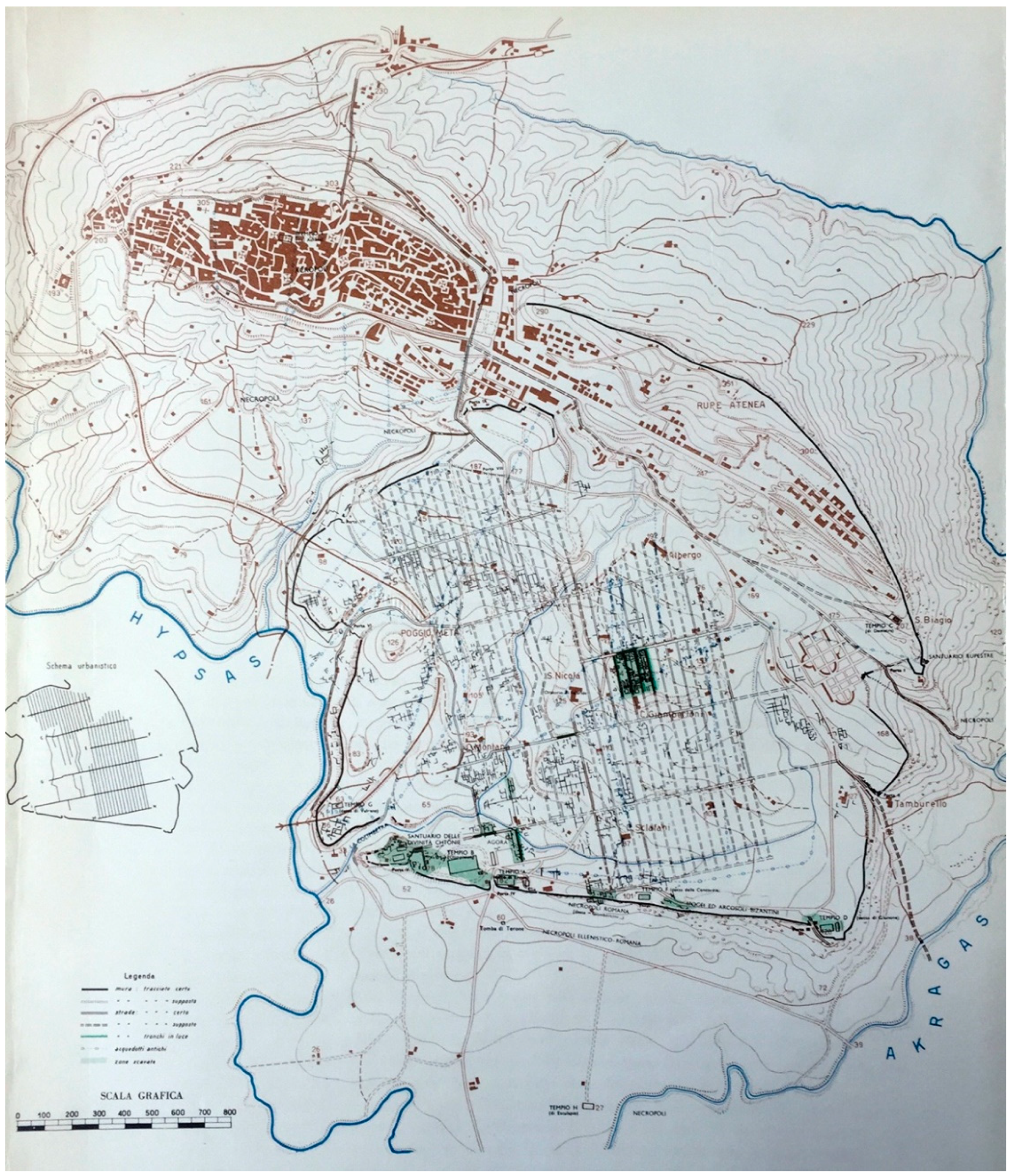
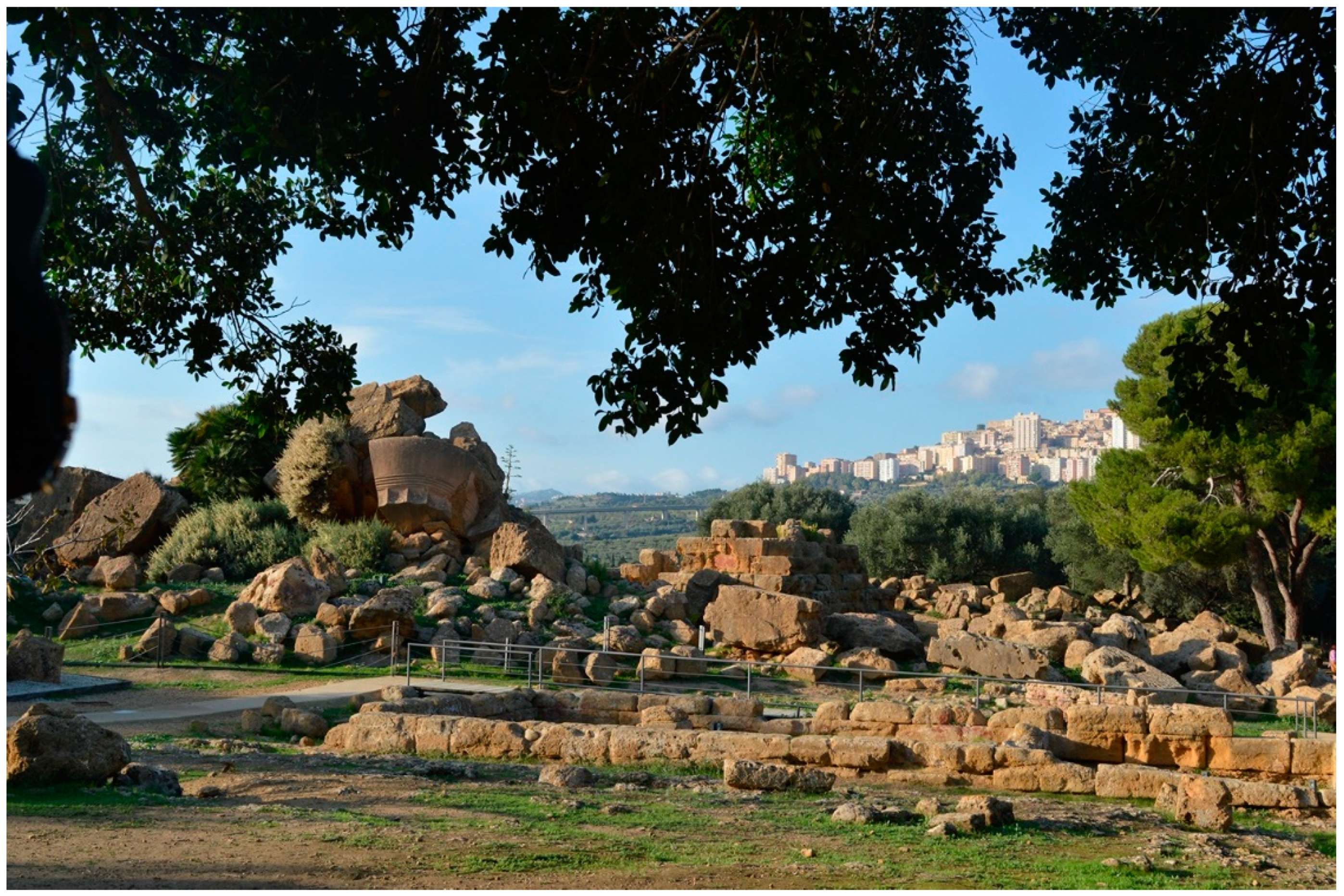
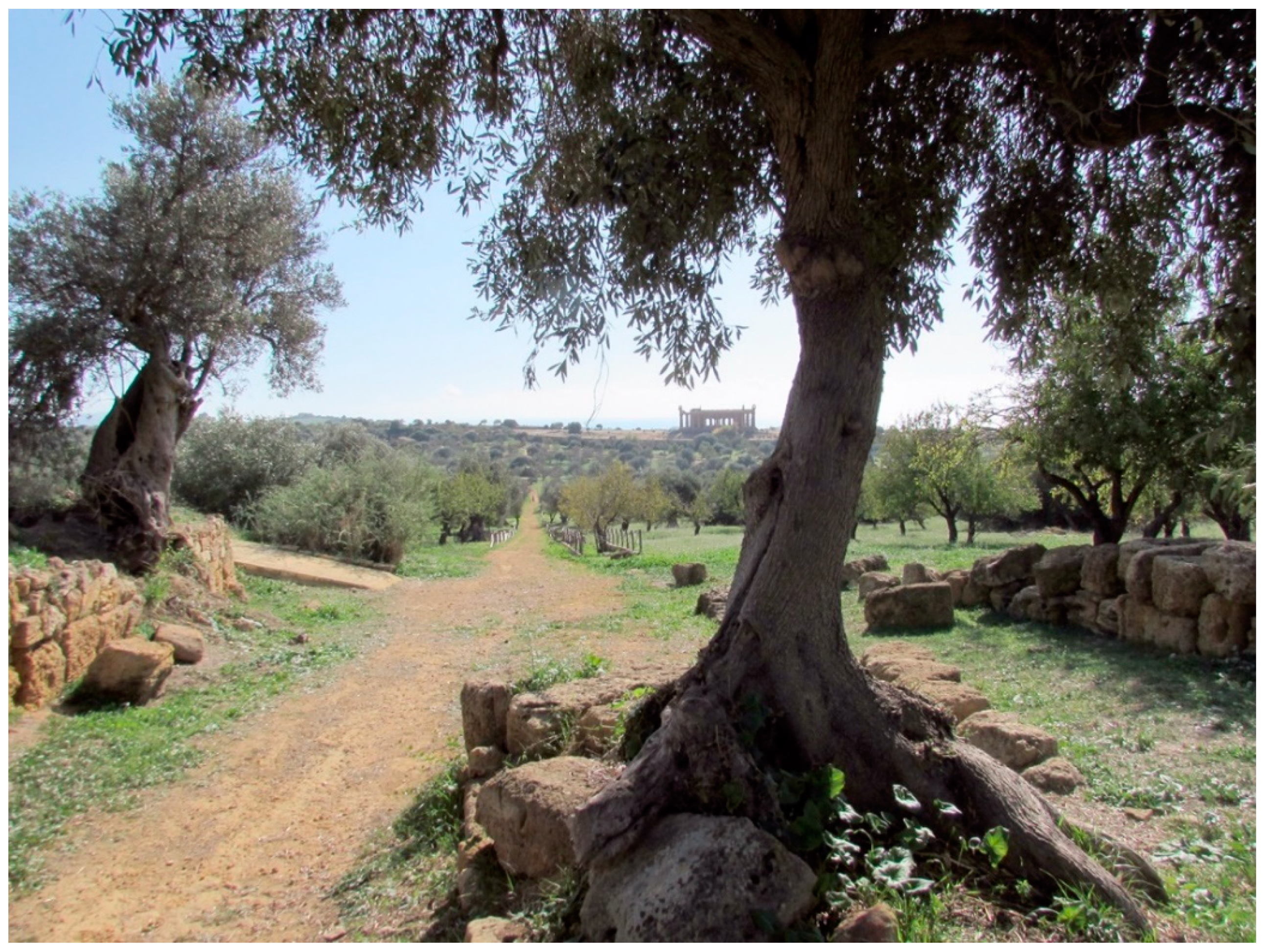
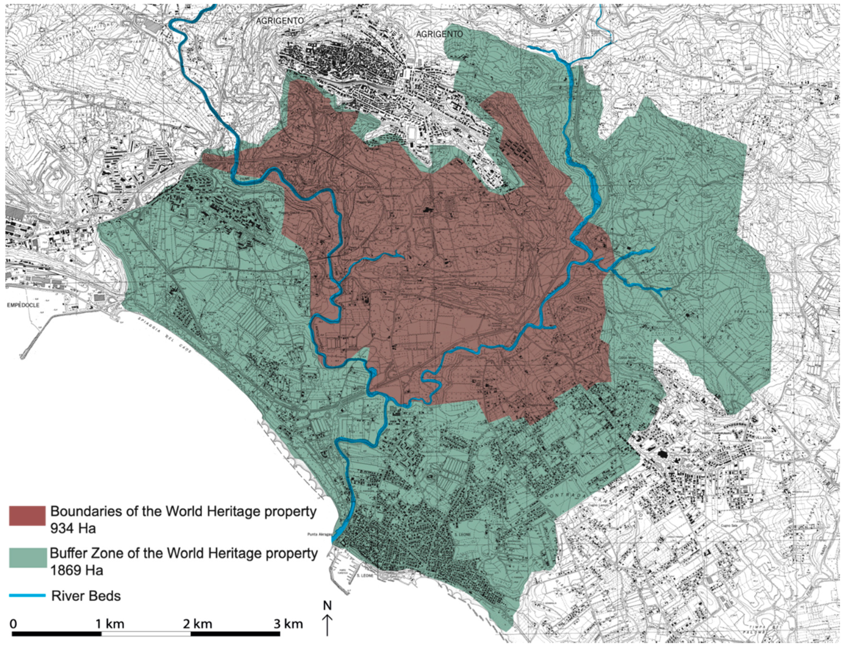
4.1. The Valley of the Temples of Agrigento as a Case Study

As an antidote to predatory Anthropocentrism, several authors have insisted on the urgent need to change current development models. Respecting the limits of the planet is the only way, according to Rockström, that we can enter what he calls “the good Anthropocene” [26].
“Neoanthropocene” is the term with which Carta proposes a new way of inhabiting the Earth, or a transition towards a new, more sensitive and responsible humanism based on the principles of social justice, coexistence of peoples and species, sharing, the circular economy, recycling and radical ecology [27].
Barbera uses the holistic interpretative categories of the landscape as a natural and cultural ecosystem to propose a radical transformation of our way of thinking and, consequently, of using the planet’s resources. To address the issues of territorial development, he argues that “through the landscape (its government, its project) one can seek and find answers to the questions of the Anthropocene” [5], p. 11 (author’s translation).
It might also be useful to heed the reflections of McNeill and Engelke [16], who suggest looking back to try to understand what brought us to the current situation and how the Great Acceleration gave a boost to the Anthropocene. A case study that allows us to analyse a landscape of the past is the archaeological site of the Valley of the Temples in Agrigento. This case study is reported because (unlike the contexts in which landscape archaeology or palaeobotany is practised) living ecosystems have been preserved there which have stratified over the centuries and have not been irreparably overwhelmed and devastated by the Great Acceleration.
The name Valley of the Temples indicates what was once the area of the Greek city of Akragas, founded at the beginning of the 6th century BC (581 BC) by Rhodesian–Cretan settlers along the southern coast of western Sicily (Figure 1), which extended for about 456 ha between the Girgenti Hill and Rupe Atenea to the north and the plateau delimited by the sacred road to the south, on a territory crossed by the two rivers, the Akragas and Hypsas.
The place where the city was founded was chosen based on political and landscape considerations. The site is located halfway between Selinus and Gela, colonies founded, respectively, by Greeks from Attica and Rhodian–Cretan populations. The two cities, both Greek colonies but enemies because they belonged to different lineages, were among the most powerful in Sicily in the 6th century BC, and they tended to expand their range of territorial influence more and more. The city of Gela founded Akragas to stem the expansionist aims of Selinus, but in a short time the subcolony became much larger, more populous, richer and more powerful than the mother city, experiencing its maximum splendour in the classical period (5th century BC) with an estimated population of 300,000 inhabitants.
From the landscape point of view, the site chosen for the foundation of Akragas has ideal morphological characteristics for the expansion of the city, for its defence and control of the territory (Figure 2). Most of the urban centre was built on a gently sloping southwestern plateau bordered to the south by a high vertical rock face rising from a plain at sea level. Six temples were built on top of the terminal edge of the plateau (including the monumental Olympieion which, with its 112.70 m at the stylobate, is the largest temple in the Hellenised world). The purpose of this placement of the temples on the edge of the rocky ridge was to show all the power and wealth of the city to intimidate any enemies that came from the sea (at the time the only access route to the territory) and to increase the monumentality and visibility of the temples.
The inclination of the plateau, on which the layout of the city was traced according to the “Hippodamian Plan”, was favourable to the disposal of waters which, with an ingenious underground water system, flowed into a retention basin. The acropolis dominated the inhabited area, built on the Girgenti hill which, at 800 m above sea level, stood out on the plateau and on the marine horizon.
The city was close to the sea but at a safe distance that allowed the enemy to be seen in time to activate defences. The connection with the sea for the transport of goods to be marketed in the Mediterranean Sea was ensured by the two rivers that bordering the city, ensuring all the advantages of a maritime city.
An imposing circuit of walls surrounded the entire city; the walls were built using the southern rocky ridge, the Girgenti hill and the Rupe Atenea to the north, taking advantage of the natural gradients connected by massive walls.
The surface delimited by the walls thus built, about 456 ha, was not entirely occupied by buildings; in fact, the steeper or more peripheral parts were used for agriculture and arboriculture. A peri-urban landscape made up of cultivated fields and fruit orchards alternating with wooded areas was already present in the ancient polycultural landscape located in the peri-urban areas of the island of Crete—motherland of Akragas—during the 4-3 millennium BC [12]. Furthermore, the presence of centuries-old olive trees within the city and next to the temples (Figure 3 and Figure 4) can, most likely, testify to the sacred character attributed to the tree as a divine gift to humanity [28].
The presence of a rock sanctuary dedicated to Demeter, goddess of nature who presided over the crops and harvesting, testifies to the cultivation of cereals, a characteristic of ancient Greek food traditions. The agricultural landscape in classical Greek times also included grazing areas; the decorations of numerous vases found at the site depict horses, and the breeding of horses for military and sporting purposes (participation in the Olympic Games) is also referenced in numerous literary sources (Diodorus Siculus, Bibliotheca Historica; Virgilio, Aeneide; Pindaro, VI Pitica and III Isthmica).
The inclusion of the city of Akragas in the Sicilian coastal landscape reached admirable levels of harmony and integration with nature which testifies, once again, to the great sensitivity to the landscape and the technical skills achieved by the Greek colonists.
The city’s heyday ended with its defeat inflicted by the Carthaginians in 406 BC. The city was almost completely destroyed and, in 339, was partially rebuilt and repopulated, without ever reaching the glories of the classical period. The history of the Greek colony ends in 210 BC with the Roman conquest during the second Punic War [29,30,31,32,33,34].
The city gradually lost importance after the Roman conquest until it was reduced, in the Middle Ages, to a small urban settlement perched on Girgenti Hill. The current urban settlement, Agrigento, is much smaller than the Greek city and has just over 55,000 inhabitants.
After the fall of Akgragas, the history of the agricultural landscape of the Greek colony follows the fate of the Sicilian landscape. Having become the first Roman province in the 3rd century, Sicily was exploited for the production of extensive wheat-based crops, for the breeding of animals (and therefore large areas were set aside for grazing), for the production of wine. The region was heavily plundered as all these products were not intended for local consumption but were transported on ships to Rome. With the spread of extensive crops, the new agricultural landscape design was the “latifundum” (large estate).
A long period of increased humidity during the last centuries of the Roman period (IV-VI century) favoured the agrarian economy in Sicily until the late Roman–Byzantine period [35]. A sudden climatic shift towards aridity, which took place in 750 AD, caused a change in the hydrological conditions with a consequent general socio-economic decline. The consequent weakening of the Byzantine communities made them particularly vulnerable to the Islamic conquest, which took place between 827 and 878 AD. As Ferrara describes,
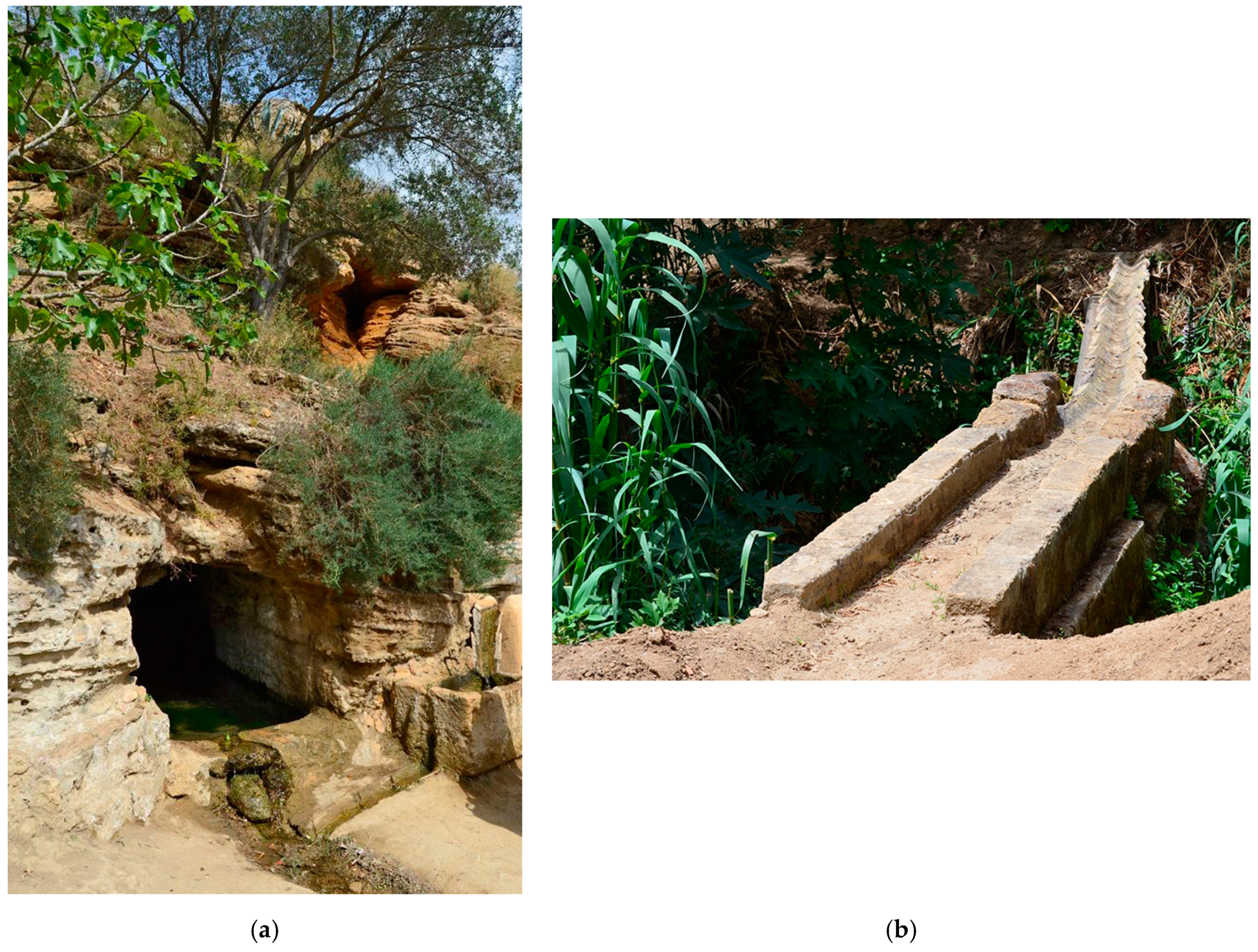
“with the arrival of the Arabs on the island, an authentic agrarian revolution began: introduction of new crops, innovative soil improvement techniques and hydraulic systems which contributed to a better use of water resources, a temporal and spatial differentiation of production and a more integrated view of the agricultural system in all its components (irrigation, energy, micro-climate and aesthetic functions): a completely different approach to agriculture which, for its holistic nature, could be indeed defined as agroecology. Such structural revolution marked deeply the Sicilian agrarian landscape; it was the beginning of the coltura promiscua system, based on an authentic intercropping of the fruit trees”
[35], p. 140.
The Arabs imported, in particular, citrus fruits which began to spread throughout the Mediterranean. Their presence contributed to the modification and enrichment of the characteristics of the Mediterranean landscape. The Arabs also introduced irrigation systems so efficient that they could greatly increase the irrigable land, replacing extensive cultivation with intensive cultivation. Even today in the Sicilian countryside, spared from the frenetic rush toward modernisation, there are remains of the ancient Arab irrigation systems that in Sicily have become so integrated into the local culture that they have also taken on names in various local dialects (saie, cunnutti, gebbie, etc.). Even today, some of the older farmers remember how they used to work.
The Norman conquest of Sicily and the subjugation of the Arabs led, starting from the late Middle Ages, to the feudal structuring of the society and, consequently, to the return to agricultural management based on the latifundum, marking a substantial regression in agricultural production compared to the Arab restructuring.
Mediterranean landscapes increased their biodiversity again when new species were introduced by the conquest of the American continent: the most important for its impact on the natural and rural landscape of Sicily was the prickly pear [12].
The structuring of agricultural production imposed on Sicily by the Romans with the large estates continued to persist until the 20th century, when agricultural mechanisation also began in Sicily. Immediately after the First World War, the Fascist regime tried to revive the ancient Roman concept of Sicily as the “granary of Italy”, but the large-scale cultivation of wheat was not well managed and impoverished the soil [35].
The large estate system was officially dismantled after World War II, but the new land system, based on small private ownership, was unable to provide peasants with sufficient means. All this indicates that agriculture in Sicily, despite the good quality of its soil and the favourable climate, does not form a solid basis for economic development for individual agricultural entrepreneurs. Furthermore, after the abolition of the feudal system and the mechanisation of agriculture, civil uses and customary rights were progressively abolished and the common lands, which were used by the resident population for both grazing and wood harvesting and temporary cultivation, were sold to private individuals [36].
For centuries, the area occupied by the ancient Greek city of Akragas, the current archaeological area, was considered the land of the civita, that is, an area available to the citizens of Agrigento. The land, which in Greek times was occupied by residential and public buildings, was used for agriculture. This equilibrium was broken when the city entered the vortex of the Great Acceleration, that is, in the post-Second World War period when the predominantly agricultural economy of Agrigento, based on the cultivation of small plots of land by individual farmers, was supplanted by a form of development based mainly on construction, producing one of the riskiest situations in Italy due to unproductive, illegal and speculative land use [32,37,38].
In 1966 a landslide [39], which affected part of the historic centre of Agrigento, showed that the urban overload, in many ways illegal, carried out between the 1950s and 1960s [40] had exceeded the carrying capacity of the soil. This distorted form of economic development
“has taken on the forms of parasitic speculation which have reached an aberrant extent in this city; the rights of nature and history have been trampled on, the physical and historical characteristics of our country have been ignored (…). The work was done in such a monstrous way that the landslide that engulfed a third of the City of Temples appeared as an inevitable, indeed coherent, reaction of nature (…) to the way in which its laws have been ignored or trampled on”
[41], p. 58; author’s translation.
The calamitous event, unexpected but perhaps foreseeable, changed the course of the history of the Valley: the Italian government subjected the area to archaeological and landscape constraints. The limitations on indiscriminate uses of the territory and construction have safeguarded the territory from the risk of succumbing to the speculative and dissipative uses of the predatory Anthropocene.
The constraints cover both the areas involved in the archaeological finds and the surrounding agricultural landscape for a total of approximately 1450 ha. The coexistence of the archaeological constraints with the landscape constraints affirms the unity of a cultural heritage in which art and nature are inseparably intertwined and recalls the need to safeguard and restore every historicised element of the territory as an inseparable whole.
In 1997, the Valley of the Temples was declared to be the cultural heritage of humanity and was included in the World Heritage List (WHL) of UNESCO; it is one of the largest archaeological sites currently registered, with a total area of 2803 ha (including boundaries and buffer zones) (Figure 5).
The effect produced by the constraints became evident in the long term, when the difference in quality between the protected area and the surroundings became visible. Outside the constrained area, the transformation processes continued to consume land and resources at breakneck speed without producing wealth. For over thirty years, the local population has refused the constraints because they were experienced as an imposition from above. Since the end of the 20th century, however, local institutions and the population have begun to manifest a desire to culturally re-appropriate the Valley, to take care of it as the noblest and most important part of the territory [42].
To promote the safeguarding, management, conservation and defence of its archaeological and landscape heritage and to promote better usability for scientific, social, economic and tourism purposes, the Region of Sicily enacted Regional Law n. 20/2000 for the establishment of the Archaeological and Landscape Park of the Valley of the Temples in Agrigento. With the establishment of the Park, an innovative form of cultural heritage management was inaugurated, experimenting for the first time with new methods of integrated enhancement of archaeological, landscape and agricultural heritage. The Archaeological Park Plan is the guiding tool for this process which aims to enhance the entire territory in its synthesis of archaeology and rural landscape [34,43,44,45,46,47,48].
The vast area of the Park today appears as a cultural landscape that has been stratified over the centuries, where archaeological finds mixed with pieces of agricultural landscape—protected by the dense blanket of territorial constraints—have been largely spared from the Great Acceleration [49].

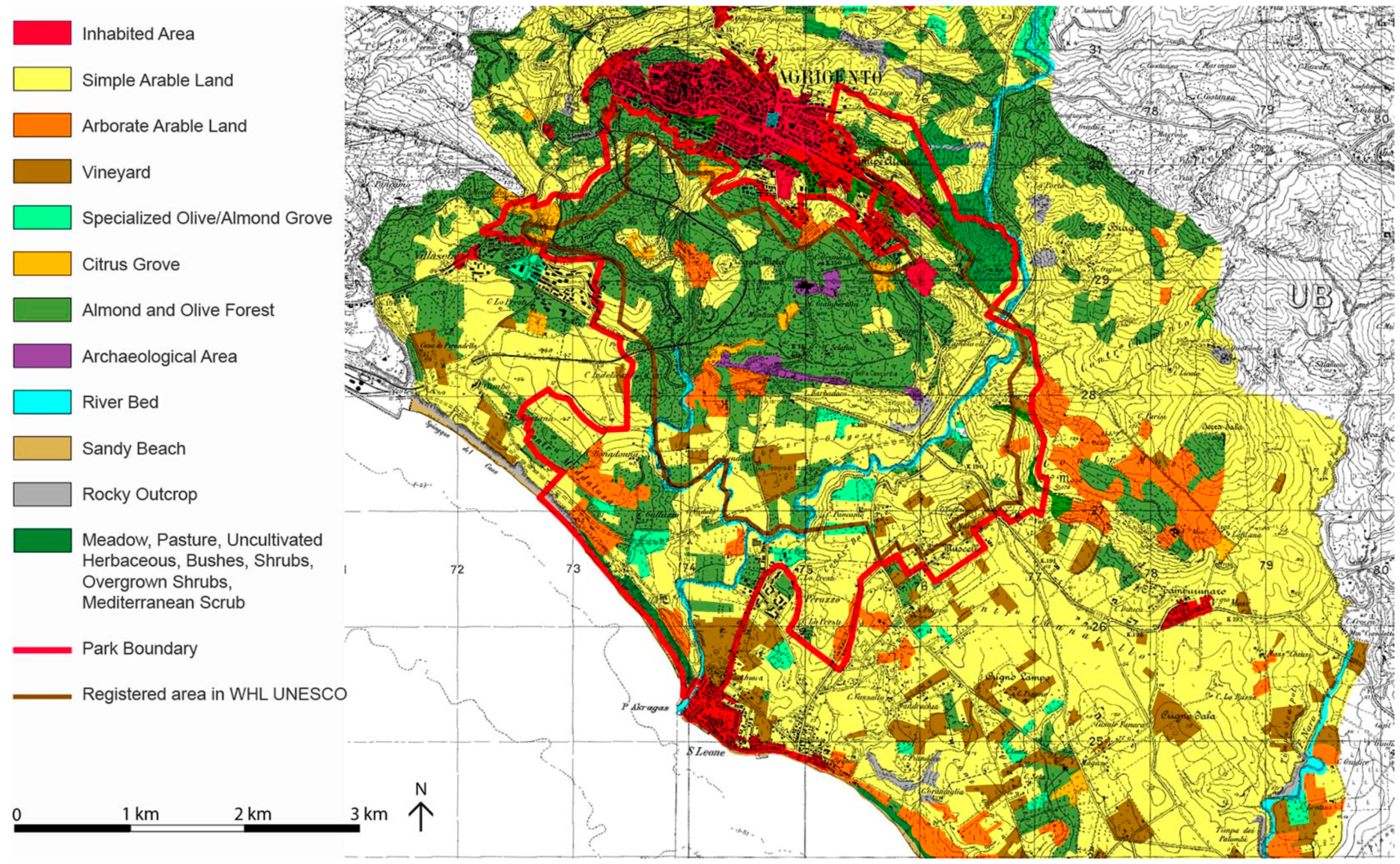
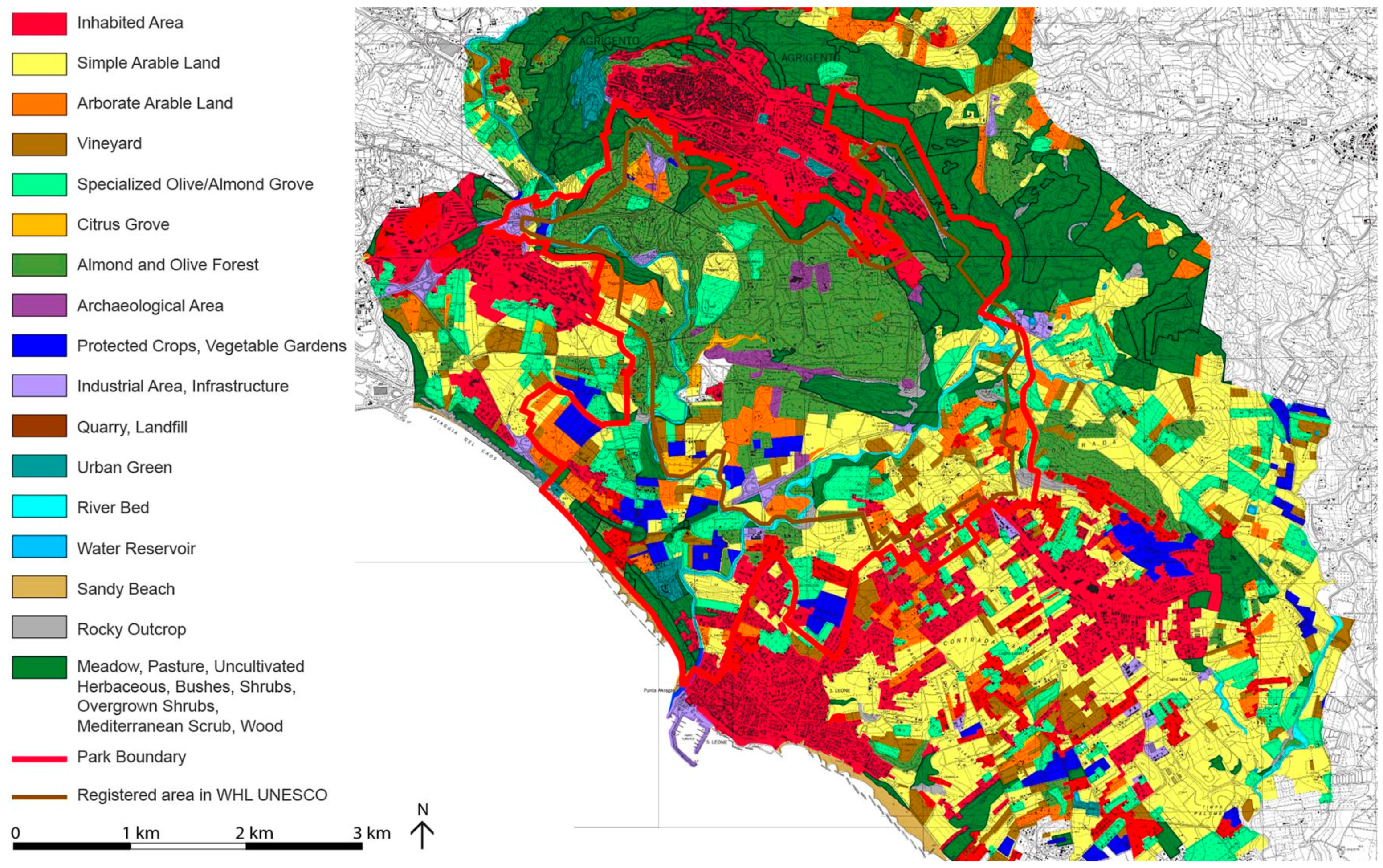
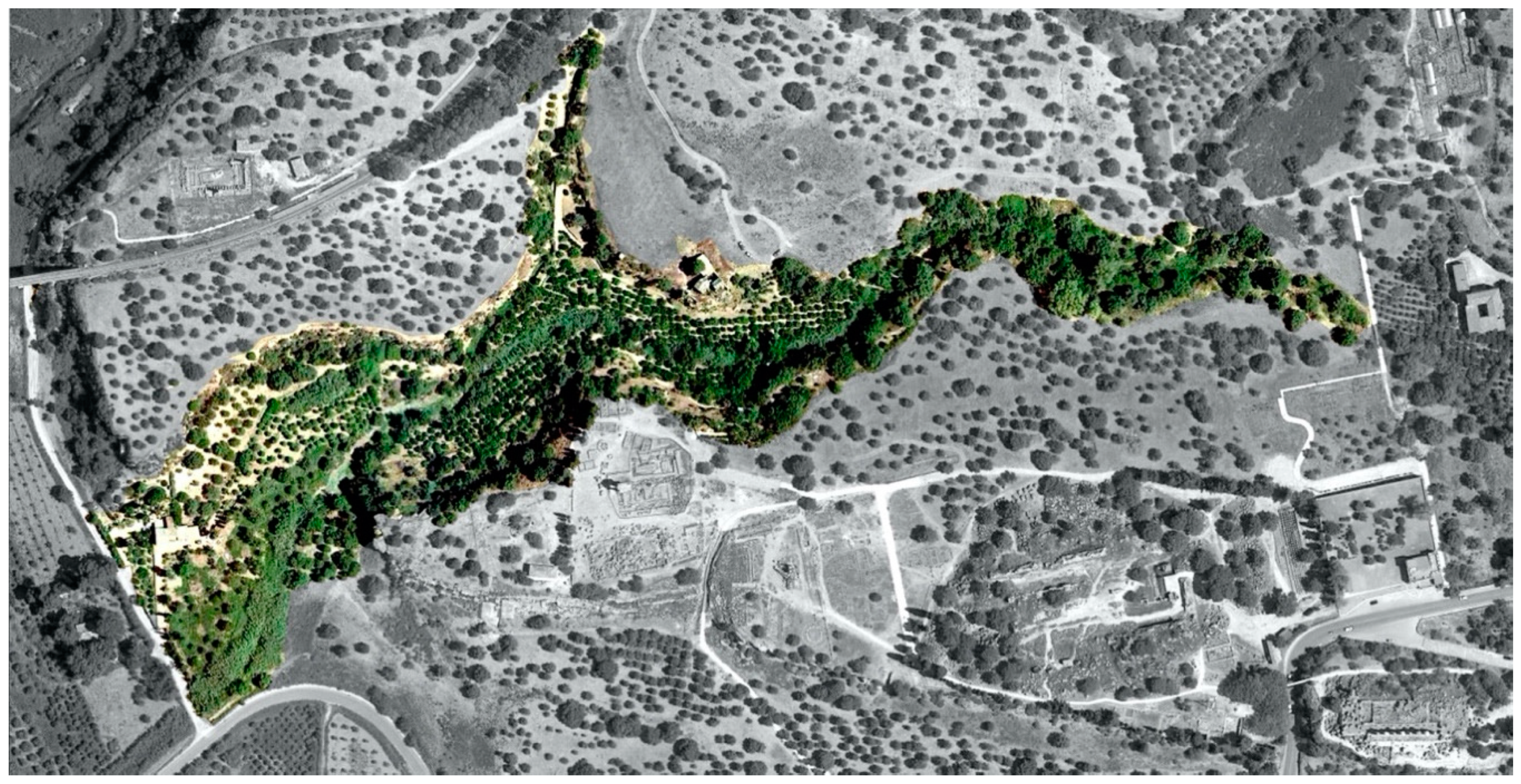
4.2. Change in Landscape Ecomosaics

During the preparation of the Park Plan, a study of the evolution of landscape eco-mosaics was produced in order to identify the configurations of the most significant landscape elements for defining urban planning choices.
The evolution was evaluated on the basis of the comparison between the ecomosaics of the area in 1955 and in 2002. Territorial biopotentiality (or biological territorial capacity, BTC, which measures the degree of relative metabolic capacity and the degree of relative antithermal maintenance of the main ecosystems, expressed in Mcal/m2/year) [50] was used as an indicator for estimating the degree of equilibrium of the territorial areas, which allowed for the comparison of ecosystems and landscapes both qualitatively and quantitatively, favouring the interpretation of territorial transformations [50]. By relating biomass to the homeostatic capacities of ecosystems, BTC helps to measure the degree of metastability of the ecosystems themselves, or their ability to conserve and maximise the use of energy [51].
The evolution of its ecomosaics has clearly demonstrated that the territory of the Valley of the Temples still preserves ecosystems which, thanks to the constraints, were preserved in a phase prior to the Great Acceleration [52]. A testimony that confirms the authenticity of the landscape is the literary, iconographic and photographic documentation that accompanies the story of the rediscovery of the archaeological site of Akragas by lovers of the landscape and archaeology, starting from the 18th century [29,53].

5. Results

5.1. Different Degree of Transformation in Landscape Ecomosaics

The comparison revealed the different evolution/involution of the landscape and the different degrees of conservation and transformation that the Valley of the Temples, protected by constraints, has undergone compared to the parts of the Agrigento area not subject to specific constraints.
From the calculation of the average BTC of the study area in 1955—a period in which urbanisation had not yet spread in the municipal area of Agrigento—the entire territory under analysis showed a much higher value of metastability than the regional average for the period (1.76 Mcal/ha/year against 1.69 in the region in 1951). The mean metastability value, on the other hand, decreased in 2002 to 1.54 Mcal/ha/year, significantly lower than the regional average (1.73).
The decrease in the overall average BTC, over 47 years (during the Great Acceleration), was caused by the occupation of agricultural land by new urbanisations, by an increase in bare land (almost 25 ha) and by over 56 ha of specialised horticultural crops, often in greenhouses. In particular, the increase in built-up areas has gone from about 207 ha in 1955 to about 1321 ha today, with an increase of 1114 ha of new buildings; thus, the agricultural land lost almost 15% of its 7710 hectares. In the agricultural landscape, arable land has decreased by over 53%, as well as the almond and olive forest of over 260 ha. The territory has been transformed with a general agronomic intensification of the surfaces (greenhouse and horticultural crops, vineyards, specialised olive/almond groves); finally, there has been an increase of 310 ha of marginal crops (meadows, pastures and uncultivated areas covered in herbaceous plants and shrubs).
The decrease in average BTC due to the reduction in the area of traditional agricultural crops would have been considerably greater if it had not been offset, in ecological terms, by the more than 117 ha of new eucalyptus woods around the city of Agrigento. These new woods were planted after the 1966 landslide with the aim of hydrogeological protection and static soil consolidation [45], though the trees introduced are foreign to the original ecosystem.
The analysis of the ecomosaics of the 1450 ha of the Valley of the Temples, that is, the portion of the territory subject to restrictions, instead showed a much higher average BTC value in 2002 than the average of the entire territory (1.54 against 1.43). While in the rest of the territory those forms of territorial organisation that recall the landscape of the Mediterranean garden have almost disappeared, in the area of the Valley of the Temples, the mixed olive grove has been maintained, albeit with a modest reduction of 21% (from 519 to 410 ha). The mixed olive grove, the so-called “forest of almond and olive trees” typical of the Valley of the Temples, is a remnant of the traditional agricultural landscape of dry arboriculture; it is a cultivation of olive and almond trees in association with other tree crops, typically fig, carob and other fruit trees, and constitutes, together with the limited citrus groves present near the waterways, an element of very significant environmental, historical and cultural importance.
Within the Park boundaries, urbanised areas, although they have increased from 20 to 136 current hectares, still represent just over 9% of the surface. Finally, due to the progressive abandonment of direct cultivation of the fields, citrus groves have been halved and arable land has been reduced by 64%.
In the maps that represent the two landscape ecomosaics (Figure 6 and Figure 7), it is evident how the mosaic tiles of the territory of the Valley that are subject to archaeological and landscape constraints (the so-called “heart of the park”, which coincides with the area registered in the WHL of UNESCO, coloured in brown in Figure 5) have remained substantially unchanged. The parts of the territory outside the archaeological area and protected by landscape restrictions (coloured in green in Figure 5) have undergone a modest transformation. The tiles of the territorial context outside the restricted area have, instead, undergone profound and sometimes irreversible transformations. Table 1 shows the values (in square meters) of the surfaces of the landscape mosaic tiles by land use categories in 1955 and 2002. Table 2 summarises and compares the main transformations of the Agrigento landscape and the landscape of the Valley of the Temples in the period examined.

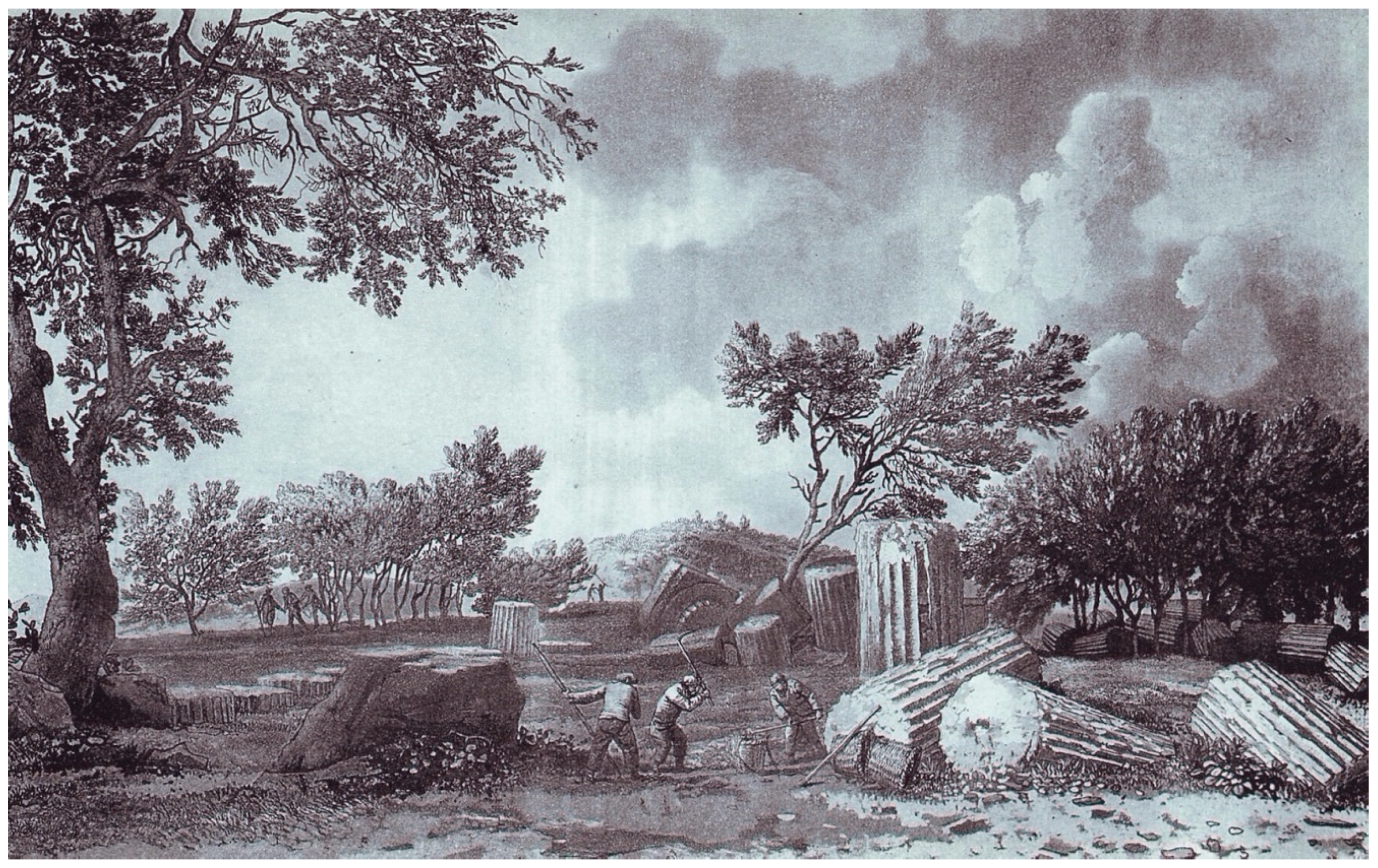
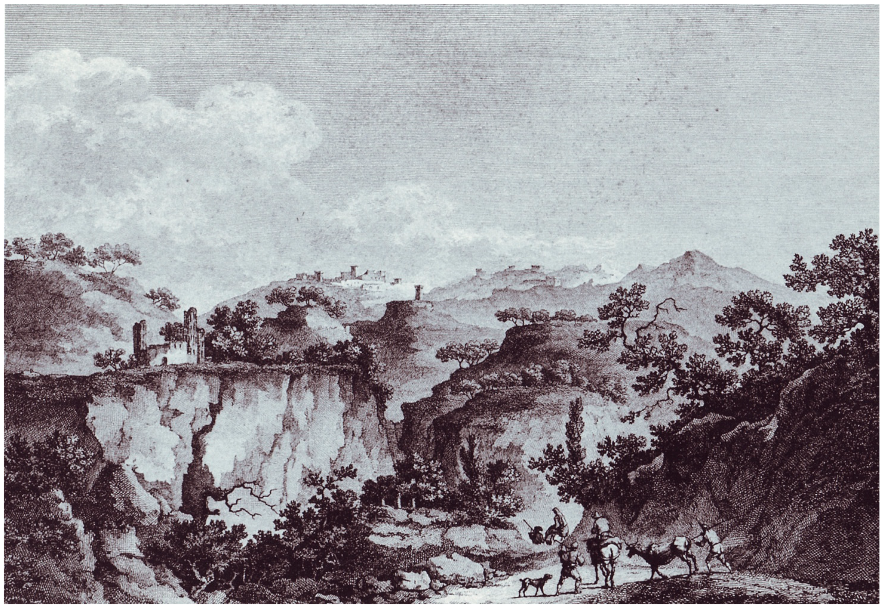
5.2. Historical Iconography of the Agricultural Landscape of the Valley of the Temples

Travellers on the Grand Tour who arrived in Agrigento described a landscape characterised by the presence, among the archaeological finds, of fruit trees, vegetable gardens and arable land. The main travellers who have crossed, written on and drawn the Valley are: J.P. d’Orville, 1727; J.H. Von Riedsel, 1767-70; P. Brydone, 1767-71; M. J. De Borch, 1776-77; H. Swimburne, 1777-78;P. Hakert, 1777; C.S. Saint Non, 1778; J. P. L. Saint Non, 1778; F. Munther, 1785-86; H. Bertles, 1786; J. W. Goethe, 1786; F. L. di Stelberg, 1792; J. G. Seume, 1802; K. F. Schinkel, 1804; W. Wilkins, 1807; J. Russel, 1815; J.A. de Gambillon, 1820; A. E. De La Salle Gigault, 1882; A. Conte de Forbin, 1823; W. Light, 1823; O. Ormonde, 1832; W. H. Bertelett, 1853; F. A. Gregovius, 1853; G.F. Hoffwailles, 1870; G. Vuillier, 1897; E. Viollet Le Duc, 1836-37; Berenson, 1953. In the illustrations accompanying their reports, there are always farmers intent on cultivating the land adjacent to the temples and ruins of the city of Akragas (Figure 8). From their descriptions, it can be deduced that the presence of fruit trees was not only in the peri-urban orchards, but that it also extended into the hilly areas; here, the absence of irrigation water required the presence of dry arboriculture which, in the Mediterranean environment, sees olive and almond trees as protagonists, followed by carob and pistachio trees.
Among the testimonies of these travellers, each of which saw and described the temples and their landscape in their own way (for the interpretation of the different literary sources, which would require an in-depth study that goes beyond the purposes of this article, see Barbera, Di Rosa, 2000 [53]; De Miro, 1994 [29]), the richest in information are those left by Johann Wolfgang Goethe, who visited Agrigento in 1786. In his travel diary (Italienische Reise, 1816), he described the agricultural landscape with a list of the cultivated crops and noted all of the aspects of the agricultural techniques of the countryside in use at the end of the 18th century. The crops and techniques described by Goethe find a perfect match in the memories and agricultural practice of the elderly peasants who are still alive today.
What is relevant, through the reading of these memories (see Table 3), is the possibility of comparing the images of the landscape described and drawn with the existing landscape; from this comparison, it can be easily seen that the landscape of the Valley of the Temples (even though partially degraded by the abandonment of crops) has not substantially changed [54]. The countryside of the Valley of the Temples is a living testimony to the transformation of Sicilian agriculture which, between the 18th and 19th centuries, led to the spread of the cultivation of fruit trees in large areas previously dominated by pastures, bare arable land and Mediterranean scrub. The traditional agricultural crops which are still established in the countryside of the Temples saw, in the period between the 18th and 19th centuries, the moment of their affirmation as crops that define the historical Sicilian agricultural landscape.
On the basis of agronomic, forestry, agricultural landscape and literary sources analyses, the Park Plan has defined a specific model for the Valley of the Temples that makes historical-settlement peculiarities and aspects of Mediterranean scenography and rurality the strong point of sustainable development, able to guarantee its protection and reproducibility over time [45].

6. Discussion

6.1. Main Issues of Agricultural–Forest Management in the Valley of the Temples

The current economic–productive structure of the agriculture in the Valley of the Temples is rather particular compared to the other contiguous agricultural areas [52,53]. Changes in the ownership structure that have taken place in the last forty years (the state-owned areas of the Park) have upset the existing corporate structure. The land subject to constraints was acquired by the public domain, and its management was given in concession to the former owners who requested it.
Before the emergence of this new reality, the land was mainly concentrated in the hands of a few landowning families. Nothing remains of this production structure today. Instead, many families cultivate only small areas of land, given in concession, around their country houses. There are fewer and fewer small farms. The problem is that it is not possible to start a profitable agricultural business in such limited areas.
Among the causes of the abandonment of raising crops is the difference between the high cost of cultivation operations and the low value of the products. The production from the gardens is characterised by local and ancient varieties and is completely unsaleable. Though their cultivation may have important results from the point of view of landscape conservation [55], it has no value from a strictly productive one [56].
Other causes are: the obsolescence of production systems; the aging of the rural population and the abandonment of agricultural activity by elderly farmers; the loss of the technical knowledge of traditional agriculture, once handed down from generation to generation.

6.2. The Living Museum of the Almond Tree for Safeguarding Intraspecific Biodiversity

From the analyses of the historical iconography, travellers’ testimonies and historical photographs, it is clear that the cultivation of the almond trees has taken on an important economic role since the 18th century. However, it was in the second half of the 19th century and in the first decades of the 20th century that a vast wooded area called the “almond forest” was formed in the Valley of the Temples.
In the 1950s, the surface of the specialised almond groves of the Valley was about 60 hectares, while that associated with olive trees (mainly) was almost 540 hectares. By the end of the century, however, due to the problems outlined above, the specialised almond groves were reduced to just over 10 hectares, while in association with the olive trees they were reduced to about 400 hectares.
Most of the residual areas occupied by the “almond forest” are now public property and in a state of decay; this was caused by the death of many plants and the thinning of the forest. The almond tree species, among all those cultivated in the Valley, is the richest in intraspecific biodiversity. There are numerous varieties that, over time, have been selected and consolidated in this campaign and are now at risk of extinction.
To address this problem, and in general to save the different varieties of Sicilian almonds from extinction, the Institute of Arboreal Cultivation of the University of Palermo, in agreement with the Superintendence of Agrigento and the Province of Agrigento, has launched a living collection of Sicilian almond varieties [57,58].
The Valley of the Temples was chosen as the ideal place to carry out the project. So, in 1996, a new almond grove, called the Living Museum of the Almond Tree, was planted on an area of about five hectares in the San Biagio valley, at the foot of the hill dominated by the Temple of Juno Lacinia (Figure 9). The new almond grove hosts over 300 varieties of almond trees from different places in Sicily: it is a genetic bank that holds the intraspecific varieties of the species. Four trees of each of species, specially grafted with branches taken from the trees of the Valley of the Temples, are cultivated for the purpose of studying and preserving their genetic heritage. Many varieties have been selected from plants born spontaneously and whose productive characteristics have been appreciated. The plantation has the appearance of a traditional almond grove where, mixed with the almond trees, there are olive, carob, pistachio, mulberry and rowan trees, as well as shrubs characteristic of the Valley’s arboriculture [59,60].
The Museum is an open-air museum that has the scientific purpose of facilitating the study of the genetic diversity of the almond tree in Sicily, identifying those varieties that best lend themselves to maintaining the quality and excellence of the taste of the Sicilian pastry tradition. The Museum also has educational purposes because it exhibits the cultivation techniques of traditional agriculture of the Agrigento area and contributes to the conservation and enhancement of the centuries-old landscape of the Valley of the Temples, encouraging cultural, ecological and educational tourism [61].
The University of Palermo and the Valley of the Temples Park have collaborated together on the establishment of a laboratory for the categorisation and conservation of germplasm. The laboratory, set up inside Case Fiandaca (an old 19th-century farmhouse), is playing a fundamental role in the study of biodiversity and landscape restoration of degraded agricultural and natural systems for the protection and enhancement of the cultural landscape of the Valley of the Temples. A permanent exhibition on biodiversity and traditional agriculture, an iconographic exhibition of the landscape of the Valley, a permanent exhibition on traditional Sicilian almond-based pastries and, finally, specific tasting and sale stations for agricultural products from the Valley of the Temples are planned in the old rural house.

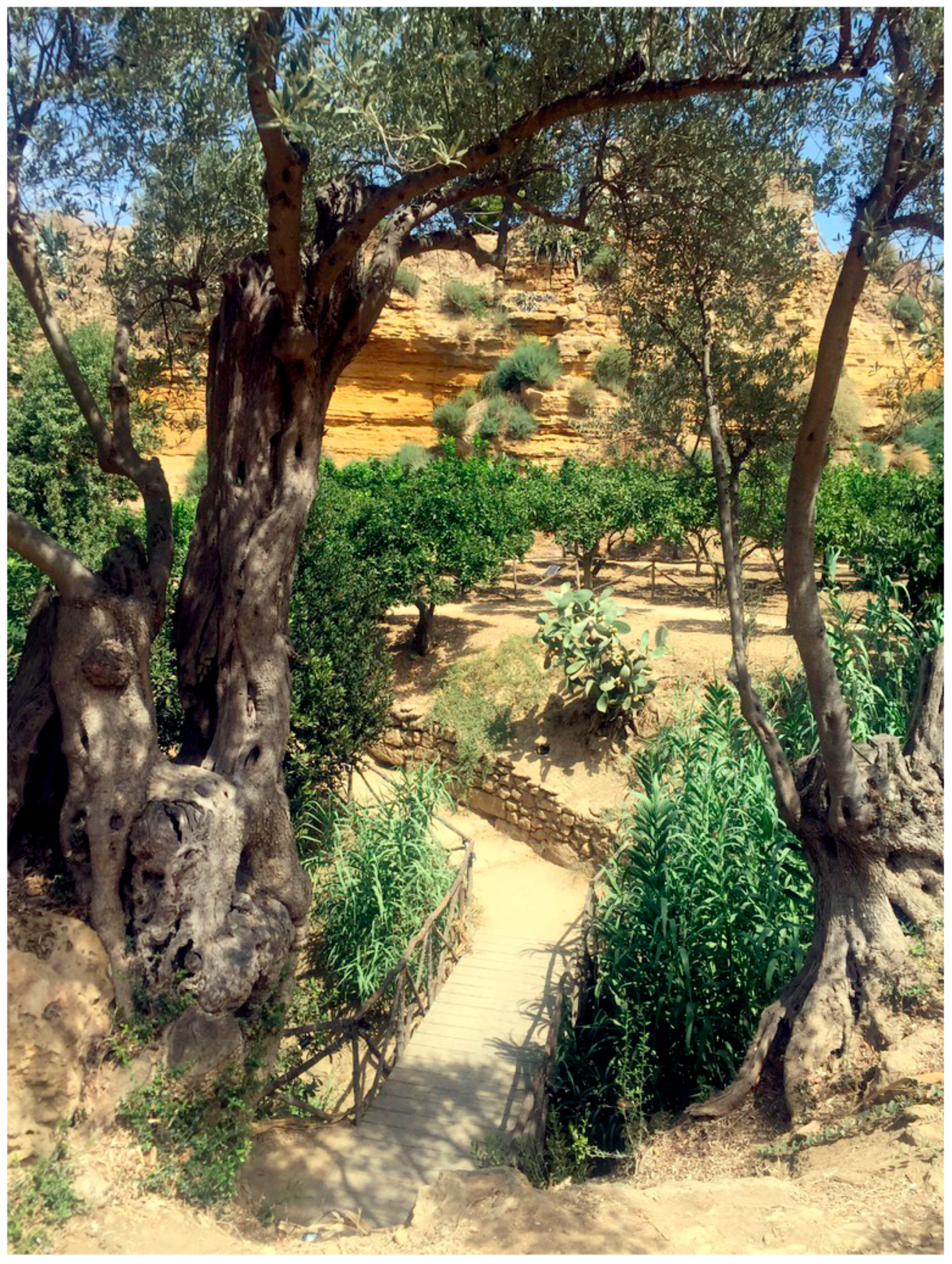
6.3. The Mediterranean Garden

Among the most precious and appreciated resources of the historical–cultural landscape of the Valley of the Temples are the so-called Jardini (Mediterranean gardens consisting of fruit trees and irrigated gardens) [62]. In Mediterranean gardens, the main cultivation matrix is made up of citrus fruits (in different varieties), to which are added: persimmons, prickly pears, figs, peaches, pears, pomegranates, quinces, walnuts, apricots. The gardens, small in size and located near springs, constitute a particularly productive polycultural system throughout the year [63].
Unlike dry arboriculture, gardens need care and watering throughout the year [64]. These landscape tiles were the ones that unfortunately suffered the most damage due to the series of factors mentioned above.
One of the most significant Mediterranean gardens of the Valley of the Temples, and which miraculously survived the Great Acceleration, is located along the narrow valley of the Kolymbethra, located between the Temple of Castor and Pollux and the Temple of Vulcan (Figure 10). Literary sources describe the Kolymbethra as an artificial reservoir, an ingenious hydraulic work carried out by Theron in the 5th century BC; Diodorus Siculus describes it as “a large basin (…) with a perimeter of seven stages (…) twenty fathoms deep (…) where the Phaeacian Aqueducts, a nursery of refined flora and abundant wild fauna” (Diodorus Siculus, Bibliotheca Historica, book XI, 25, 1st century AD; author’s translation).
Having lost its original function as an artificial lake, the reservoir was subsequently transformed, with adequate terracing, into a Mediterranean garden. The French traveller Jean-Claude Richard de Saint-Non in his notes, published at the beginning of the 19th century (Voyage pittoresque à Naples et en Sicil, 1829), testifies that, already at that time, the valley had taken on the form of a luxuriant citrus grove (Figure 11).
The oral testimonies collected confirmed the presence of a Mediterranean garden which, already at the beginning of the 20th century, appeared very ancient, while none of the contemporary peasants recalled the initial plan or remembered who the architect had been. The garden was cultivated continuously until the 1980s. Subsequently, both due to aging and the lack of generational turnover of the workforce, and to the status of the archaeological area as state property, the garden was abandoned by the peasants. It has thus been transformed from a luxuriant place to a heap of brambles, also used illegally as a landfill.
Faced with the risk of forever losing this heritage of considerable landscape, genetic and cultural value, an initiative to start the process of recovering the ancient garden has been started [65]. The Superintendence for Cultural Heritage of Agrigento, the University of Palermo and the FAI (Fondo Ambiente Italiano) have been involved in support of the initiative.
For the recovery of the Kolymbethra, the formula of the free concession of a public domain to a private body was used; in October 1999, the FAI was granted the management of the garden for a period of 25 years, dealing with restoration, maintenance, promotion, opening to the public and tourist use.
From 1999 to 2001, the garden was patiently rebuilt thanks to the collaboration between the Department of Arboreal Cultures of the University of Palermo, the FAI, the Agrigento Superintendence and the contribution of elderly farmers and labourers of the local area, custodians of the ancient and traditional techniques of cultivation, reproduction, pruning and collection and regimentation of the waters [66].
The garden was returned to the public in 2001, equipped with new routes, guided tours and a new outdoor dining area. The dry-stone walls that supported the terraces that shaped the valley floor have been restored (Figure 12), at the centre of which the waters coming from the numerous hypogea of Greek origin (Figure 13), still functioning today, are channelled. Through pruning, grafts and new plants, the Mediterranean garden has been restored with all its characteristics: on the slopes between the tuff walls and the valley floor, there are olive trees (Olea europaea) (Figure 14), almond trees (Prunus dulcis) and pistachios (Pistacia vera), the only species capable of producing in such inhospitable places. Everywhere, then, various fruit trees are used: from pomegranates (Punica granatum), located mainly along the edges of the river banks to myrtles (Myrtus communis), which today we find (in almost arboreal forms) cultivated on the terraces; fig trees (Ficus carica), pear trees (Pyrus communis), apple trees (Malus domestica), plum trees (Prunus domestica), apricot trees (Prunus armeniaca), medlar trees (Eryobotria japonica), persimmon trees (Diospiros kaki), quince trees (Cydonia oblonga), white mulberry trees (Morus alba), red mulberry trees (Morus nigra), prickly pear (Opuntia ficus-indica). The trees are seemingly distributed in no apparent order; in reality, they are distributed according to a practical criterion used by local farmers who, having identified the planting site, have chosen the most suitable plant to enhance its production potential [67].
A vegetable garden (Figure 15) has been created near a water collection tank where seasonal vegetables are grown in rotation. The traditional irrigation system of ancient Arab origins [68] has been restored and uses the water that still flows from the ancient aqueducts. It is a system based on the channelling of water which, made to flow through channels and controlled by the opening of special shutters (Figure 13b), reaches the fruit trees.
It should be emphasised that the restoration of the Kolymbethra garden is mainly for cultural and museum purposes. In fact, the visit to the garden is offered to tourists who visit the archaeological area of the Valley of the Temples with an integrated entrance ticket. As mentioned above, restoring a state of equilibrium in a pre-disturbance phase cannot be adopted as a generalisable method because the surrounding situations have changed. Even in the agricultural management of Kolymbethra, for example, the new technology of sub-irrigation was introduced to integrate the irrigation carried out with the Arab system. In this case, in fact, it was estimated that the climatic regime in the Arab era was much more humid and, therefore, there was abundant water available for irrigation. Today the climatic regime is more arid and, therefore, it is necessary to save as much water as possible. Subirrigation, by considerably reducing the dispersion of water by evaporation, allows significant water savings and produces better results for the trees.
One of the most important values of Kolymbethra is that it is a formidable source of biodiversity; of particular value is the genetic heritage that its trees preserve: the only species of orange is represented here by as many as nine ancient varieties, largely no longer cultivated (Figure 16). This garden also preserves the traces of traditional agricultural techniques, eliminated elsewhere by the modernisation process of agriculture which, in the last fifty years, has profoundly reshaped the Sicilian agricultural landscape. Furthermore, traditional agricultural landscapes preserve biodiversity in terms of flora, fauna and habitats [69]. The vegetation that grows spontaneously on the calcarenite steep slopes of the Kolymbethra is remarkable. It consists of Mediterranean maquis dominated by wild olive [70,71], in the sunny and xeric slopes, and laurel formations in the shaded part of the valley, which represent in Sicily a vegetation of particular phytogeographic interest [72].

6.4. The Productive Dimensions of the Historical Landscape. The Landscape Regeneration Project

The Living Museum of the Almond Tree and the restoration of the Kolymbethra Garden were the first sprouting of a rebirth which blossomed after almost half a century of hostility towards the archaeological area of the Valley of the Temples, thanks to the collaboration between universities, the public administration, the third sector and private entrepreneurs. This effort represents a model of good practices for the enhancement of the archaeological and landscape heritage since, from a repressive model imposed by the State, we have passed to a collaborative and proactive model that also leaves room for private initiative.
Following the success of the two projects described above, the Archaeological Park Authority has undertaken other important initiatives to manage the 1400 hectares of land in a sustainable way. To actively safeguard the traditional agricultural landscape, productive functions have been associated with cultural, ethical, aesthetic and recreational functions.
The set of initiatives undertaken by the Park Authority gave life to the Landscape Regeneration project. Starting from the landscape as an element of creative inspiration, the project pursues the objective of keeping the historical memory of ancient production practices alive, proposing them for cultural and educational purposes. Some areas of the park, not containing archaeological finds have been used for organic farming, for the production of high-quality food and wine products, recovering and updating, where possible, the agronomic practices of the ancient Sicilian tradition.
To achieve these objectives, the Park Authority made use of the collaboration of the University of Palermo and leading companies in the agri-food sector. Other partners in the project are the Kaos Cultural and Railway Activities Association, for the reactivation of the railway line that crosses the Park, and FAI, which manages the Kolymbethra Garden.
The Landscape Regeneration project pursues four main objectives which are integrated with each other: appreciating the environmental heritage, agricultural production, environmental education, recovery and requalification of the landscape. For each issue, the project foresees specific actions, listed below.

6.4.1. Appreciating the Environmental Heritage

In addition to the integration of six hectares of irrigated orchards of the Kolymbethra Garden as an integral part of the use of the Archaeological Park, three other itineraries have been designed: a visit to the Goethe Garden, a vegetable garden created in the land around Casa Barbadoro, an ancient rural building at the foot of the Temple of Concordia, featuring the crops and agronomic techniques of the late 18th century, as described by Goethe in his travelogue; an environmental itinerary, almost four kilometres long, from the Temple of Vulcan to the Temple of Demeter, where the unique characteristic of the local ecosystems are illustrated; the Vegetable Patriarchs itinerary, to become familiar with the monumental centuries-old trees, including olive, carob, pistachios and myrtles trees (for the identification, cataloguing and localisation of monumental trees, and the cataloguing of plant and animal species, see Politecnica, 2003).

6.4.2. Agricultural Production

Since 2005, the Park Authority has registered the Diodoros trademark to identify and certify the quality of the agricultural production of the Park’s land. The olive groves and vineyards have been granted, in concession to local agricultural companies, the highest quality profile which, with their methodological and production experience, have made it possible to recreate and revive high quality traditional products, exploiting natural resources hitherto unused. More than 152 hectares of land have been tendered for private bidding, and the use of more than 117 hectares has been requested by and granted to private operators. The basket of products under the Diodoros brand, initially consisting of oil and wine, has been enriched with products derived from the processing of almonds, Sicilian black bee honey and the milk of Girgentane goats, whose breeding has recently been reintroduced in the valley.
As Vesalon and Cretan observe [73], the function of the brand is, above all, to represent, innovate or construct a specific imagery for a place and to transmit it through new narratives. The power of branding is, above all, to create or reshape the image of a place. In the context of the Valley of the Temples, the Diodoros brand has worked very well in transforming the imaginary of Agrigento from a place of illegality into a territory of excellence which, in the shadow of the temples, produces organic products with eco-sustainable techniques inspired by the most ancient agricultural traditions whose origins date back to the ancient Greek and Arab cultures.
The initiative has received the appreciation and emotional involvement of the local population for the rediscovery of traditional production methods and local products; for private partners, the project represented an opportunity for investment and development, creating jobs and generating a new economy.
In 2014 the Agri Gentium project was launched in which more than 152 hectares of agricultural land in the Park were offered to three types of subjects to pursue differentiated purposes: social gardens to be allocated free of charge to citizens to promote socialisation processes and stimulate the sense of belonging; agricultural areas to be used for rehabilitation and social reintegration activities for disadvantaged people; new productive agriculture with products to be marketed under the Diodoros brand for the recovery of uncultivated or abandoned areas for production purposes.

6.4.3. Environmental Education

The Living Museum of the Almond Tree has been expanded with the planting of olive and pistachio varieties and has been transformed into the Living Museum of Non-irrigated Fruit Species in Sicily. The museum has also been integrated with the Laboratory for the Characterisation and Conservation of Almond, Olive and Pistachio Germplasm.
The Oliver: From Olive to Oil environmental education program was developed, aimed primarily at school-age children; the children are directly involved in the production processes, from the harvesting olives in the field to the subsequent pressing in the mill.

6.4.4. Restoration and Requalification of the Landscape

In 2009, the Thousand Almonds project was launched which made it possible to plant a thousand almond seedlings in the Valley to contribute to the reconstruction of the damaged ancient heritage of almonds. The project was developed and implemented by the FAI, together with the Office for Infrastructural Interventions of the Regional Agriculture and Forestry Department, the Feudo Principi di Butera and the Department of Arboreal Cultures of the University of Palermo.
In collaboration with the Kaos Railways Culture and Activities Association, an alternative mobility project was launched through the recovery of the ancient railway line, dating back to 1874, which crosses the park.
Thanks to its holistic vision of the landscape as a natural and cultural ecosystem, the Landscape Regeneration project won the Italian Landscape Award in March 2017, assigned by the Ministry for Cultural Heritage and Activities and Tourism. The project was also nominated to represent Italy in the 5th edition of the Landscape Award of the Council of Europe for maintaining a harmonious interaction between nature and culture through the protection of the landscape.

7. Conclusions

According to Niles [73,74], traditional agriculture is usually considered a relic of the past, an inefficient way of farming the land. In reality, and this is amply demonstrated by the case of the Valley of the Temples, traditional agriculture is one of the richest testimonies of human environmental experience, one of the most successful ways to establish a relationship of collaboration with the nature that is transmissible and sustainable [13].
Similar observations are contained in the ICOMOS-IFLA Principles Concerning Rural Landscapes as Heritage (2017), which considers rural landscapes as a vital component of human heritage that includes technical, scientific and practical knowledge relating to human–nature relations. Rural landscapes and traditional agriculture also provide multiple economic and social benefits, cultural support and ecosystem services for human societies.
The case study of the Valley of the Temples in Agrigento was observed from the point of view of the study of the archaeology of rural landscapes, and it emerged that these landscapes are repositories of the ecosystem’s values and the sustainability of the exploitation of environmental resources in the long term, values that have disappeared elsewhere.
The good practices analysed make it possible to evaluate how the results achieved are able to favour the dissemination and enhancement of the cultural values borne by the landscape. The best practices with the greatest impact concern: initiatives capable of keeping alive the historical memory of ancient production practices and using them as a basis for new creative products; saving plant species from extinction through germplasm banks and living collections of trees; appreciating the biodiversity of mixed crops (Mediterranean garden) as a value; facilitating cooperation between the public administration, private entrepreneurs and research institutes for the management of state-owned agricultural land while maintaining the diversity of the landscape and habitats; creating of economic opportunities linked to local products in harmony with nature and with the culture of the communities concerned [75].
The Park Authority, as the territorial body responsible for the planning and management of the Archaeological Park, has prepared projects and plans that involve top-down processes. However, it has also activated processes for the involvement of the local population, aimed at schoolchildren, entrepreneurs, farmers as well as B&B owners [61], with the aim of reaching the common citizen. It should be emphasised that these actions open up new and interesting research perspectives. Indeed, this process of involvement, referring to a territorial context that expresses a very strong identity value, could be channelled into the processes that lead to the formation of an ecomuseum, considered as a powerful tool for the participatory management of natural and cultural heritage [75,76]. To this end, it is necessary to create a community capable of recognising its territory as a living heritage, of identifying itself with it and of actively participating in its transmission, communication and enhancement.
We close these reflections on the trajectories of the landscape through the Anthropocene with the same authors with whom we opened this article. Crutzen and Stoermer seemingly expressed a prophecy when, in 2000 (long before we could have imagined the global pandemic that arrived in 2020), they claimed that:
“without major catastrophes like an enormous volcanic eruption, an unexpected epidemic, a large-scale nuclear war, an asteroid impact, a new ice age, or continued plundering of Earth’s resources by partially still primitive technology (…) mankind will remain a major geological force for many millennia, maybe millions of years, to come. To develop a world-wide accepted strategy leading to sustainability of ecosystems against human induced stresses will be one of the great future tasks of mankind, requiring intensive research efforts and wise application of the knowledge (…). An exciting, but also difficult and daunting task lies ahead of the global research and engineering community to guide mankind towards global, sustainable, environmental management”
[1], p. 18.
As we have demonstrated, the context of the Valley of the Temples, spared by the Great Acceleration, is a historical landscape that contains a vast archive of practices, knowledge and living plant and animal species. This “fertile ground” is particularly suitable for the growth of new management models that prove to be truly durable and sustainable in the long term.

Funding

Financial support from “Fondo di Finanziamento della Ricerca di Ateneo (FFR 2019)” of the University of Palermo.

Institutional Review Board Statement

Not applicable.

Informed Consent Statement

Not applicable.

Data Availability Statement

The data supporting the reported results can be found in the bibliographical references.

Acknowledgments

The drafting of the article was supported by interviews with those who, from a scientific, administrative and managerial point of view, participated in the enhancement process of the Valle dei Templi Park. The author thanks Giuseppe Barbera of the University of Palermo—Scientific Manager of the project for the realisation of the Living Museum of the Almond Tree, the recovery of the Kolymbethra Garden and the drafting of the Landscape Regeneration project—for his scientific insights, as well as for valuable advice and encouragement. The author thanks Giuseppe Lo Pilato—landscape agronomist, agricultural entrepreneur and director of the Kolymbethra Garden—for the description of the process of building a public/private partnership for the enhancement of cultural heritage and for having testified, from the point of view of the private farmer, the difficulties encountered in the implementation/management process. The author thanks Calogero Liotta—agronomist and part of the staff of the Park Authority of the Valley of the Temples—for the description, from the point of view of the managing public body, of the processes, difficulties, successes and failures encountered in the planning and management of the landscape enhancement of the archaeological/rural area of the Park. The author thanks the three reviewers of the article for their valuable suggestions and the invitation to enrich the topics with references to other authors and complementary themes.

Conflicts of Interest

The author declares no conflict of interest.

References

  1. Crutzen, P.J.; Stoermer, E.F. The ‘Anthropocene’. Int. Geosph. Biosph. Programme (IGBP) Glob. Chang. Newsl. 2000, 41, 17–18. [Google Scholar]
  2. Crutzen, P.J. Benvenuti nell’Antropocene. L’uomo ha cambiato il clima, la Terra entra in una nuova era; Mondadori: Milano, Italy, 2005. [Google Scholar]
  3. Steffen, W.; Crutzen, P.J.; McNeill, J.R. The Anthropocene: Are Humans Now Overwhelming the Great Forces of Nature? Ambio 2007, 36, 614–621. [Google Scholar] [CrossRef]
  4. Rockström, J.; Steffen, W.; Noone, K.; Persson, Å.; Chapin, F.S., III; Lambin, E. Planetary Boundaries: Exploring the safe operating space for humanity. Ecol. Soc. 2009, 14, 2. [Google Scholar] [CrossRef]
  5. Barbera, G. Antropocene, Agricoltura e Paesaggio; Aboca: Sansepolcro, Italy, 2019. [Google Scholar]
  6. Campbell, B.M.; Beare, D.J.; Bennett, E.M.; Hall-Spencer, J.M.; Ingram, J.S.; Jaramillo, F. Agriculture Production as a Major Driver of the Earth System Exceeding Planetary Boundaries. Ecol. Soc. 2017, 22, 4. [Google Scholar] [CrossRef]
  7. Lennon, M. Nature conservation in the Anthropocene: Preservation, restoration and the challenge of novel ecosystems. Plan. Theory Pract. 2015, 16, 285–290. [Google Scholar] [CrossRef]
  8. Barbera, G.; Biasi, R.; Marino, D. I paesaggi Agrari Tradizionali. Un Percorso per la Conoscenza; FrancoAngeli: Milano, Italy, 2014. [Google Scholar]
  9. Bazan, G.; Speciale, C.; Castrorao Barba, A.; Cambria, S.; Miccichè, R.; Marino, P. Historical Suitability and Sustainability of Sicani Mountains Landscape (Western Sicily): An Integrated Approach of Phytosociology and Archaeobotany. Sustainability 2020, 12, 3201. [Google Scholar] [CrossRef] [Green Version]
  10. Bazan, G.; Castrorao Barba, A.; Rotolo, A.; Marino, P. Vegetation series as a marker of interactions between rural settlements and landscape: New insights from the archaeological record in Western Sicily. Landsc. Res. 2020, 45, 484–502. [Google Scholar] [CrossRef]
  11. Agnoletti, M. Italian Historical Rural Landscapes: Dynamics, Data Analysis and Research Findings; Springer: Dordrecht, The Netherlands, 2013. [Google Scholar]
  12. Barbera, G.; Cullotta, S. The Traditional Mediterranean Polycoltural Landscape as Cultural Heritage: Its Origin and Historical Importance, Its Agro-Silvo-Pastoral Complexity and the Necessity of Its Identification and Inventory. In Biocultural Diversity in Europe; Agnoletti, M., Emanueli, F., Eds.; Springer: Dordrecht, The Netherlands, 2016. [Google Scholar]
  13. Cevasco, R.; Moreno, D.; Hearn, R. Biodiversification as an historical process: An appeal for the application of historical ecology to bio-cultural diversity research. Biodivers. Conserv. 2015, 24, 3167–3183. [Google Scholar] [CrossRef]
  14. Lewis, S.L.; Maslin, M.A. Il Pianeta Umano; Einaudi: Torino, Italy, 2019. [Google Scholar]
  15. Crutzen, P.J. Geology of mankind. Nature 2002, 415, 3. [Google Scholar] [CrossRef]
  16. McNeill, J.R.; Engelke, P. La Grande Accelerazione. Una Storia Ambientale dell’Antropocene Dopo il 1945; Einaudi: Torino, Italy, 2018. [Google Scholar]
  17. Foster, J.B.; Holleman, H.; Clark, B. Imperialism in the Anthropocene. Mon. Rev. 2019, 71, 70–88. [Google Scholar] [CrossRef]
  18. Meadows, D.H.; Meadows, D.L.; Randers, J.; Behrens, W.W. I limiti dello sviluppo. Rapporto del System Dynamics Group Massachusetts Institute of Technology (MIT) per il Progetto del Club di Roma sui Dilemmi Dell’umanità; Mondadori: Milano, Italy, 1972. [Google Scholar]
  19. Diffenbaugh, N.S.; Burke, M. Global Warming Has Increased Global Economic Inequality. Proc. Natl. Acad. Sci. USA 2019, 116, 9808–9810. [Google Scholar] [CrossRef] [Green Version]
  20. Pellegrino, G.; Di Paola, M. Nell’Antropocene. Etica e politica alla fine di un mondo; DeriveApprodi: Roma, Italy, 2018. [Google Scholar]
  21. Rockström, J.; Steffen, W.; Noone, K.; Persson, Å.; Chapin, F.S.; Lambin, E.F. A safe operating space for humanity. Nature 2009, 461, 472–475. [Google Scholar] [CrossRef] [PubMed]
  22. Steffen, W. Global Change and the Earth System. A Planet under Pressure; Springer: Berlin/Heidelberg, Germany; New York, NY, USA, 2004. [Google Scholar]
  23. Steffen, W.; Richardson, K.; Rockström, J.; Cornell, S.E.; Fetzer, I.; Bennett, E.M. Planetary Boundaries. Guiding human development on a changing planet. Science 2015, 347, 6223. [Google Scholar] [CrossRef] [PubMed] [Green Version]
  24. Tarolli, P.; Vanacker, V.; Middelkoop, H.; Brown, A.G. Landscapes in the Anthropocene. State of the Art and Future Directions. Anthropocene 2014, 6. Available online: https://www.sciencedirect.com/science/article/pii/S2213305414000654 (accessed on 15 March 2021). [CrossRef]
  25. Tscharntke, T.; Klein, A.M.; Kruess, A.; Steffan-Dewenter, I.; Thies, C. Landscape Perspectives on Agricultural Intensification and Biodiversity—Ecosystem Service Management. Ecol. Lett. 2005, 8, 857–874. [Google Scholar] [CrossRef]
  26. Rockström, J.; Klum, M. Grande Mondo, Piccolo Pianeta. La Prosperità entro i Confini Planetari; Edizioni Ambiente: Milano, Italy, 2015. [Google Scholar]
  27. Carta, M. Città Aumentate; Il Margine: Trento, Italy, 2021. [Google Scholar]
  28. Miles, M.M. Birds around the Temple: Construction a Sacred Environment. In Valuing Landscape Classical Antiquity; McInerney, J., Sluiter, I., Eds.; Leiden: Boston, MA, USA, 2016. [Google Scholar]
  29. De Miro, E. La Valle dei Templi; Sellerio: Palermo, Italy, 1994. [Google Scholar]
  30. Griffo, P. Akragas—Agrigento; Legambiente: Palermo, Italy, 1998. [Google Scholar]
  31. Badami, A. Il parco e l’ombra. In Riscoprire il Paesaggio della Valle dei Templi; Leone, M., Ed.; Alaimo: Palermo, Italy, 2003; pp. 113–127. [Google Scholar]
  32. Badami, A. Caractéristiques urbanistiques du site archéologique d’Akragas. Du site archéologique au Parc Archéologique et Paysager de la Vallée des Temples d’Agrigente. In Patrimoine et Créativité. Une Alliance pour le Développement Durable; Carta, M., Ed.; LISt Lab: Trento, Italy, 2016; pp. 62–87. [Google Scholar]
  33. Leone, M. Riscoprire il Paesaggio della Valle dei Templi; Alaimo: Palermo, Italy, 2003. [Google Scholar]
  34. Lo Piccolo, F. Progettare le Identità del territorio. Piani e Interventi per uno Sviluppo Locale Autosostenibile nel Paesaggio Agricolo Della Valle dei Templi di Agrigento; Alinea: Firenze, Italy, 2009. [Google Scholar]
  35. Ferrara, V.; Ekblom, A.; Wästfelt, A. Biocultural Heritage in Sicilian Olive Groves; The Importance of Heterogeneous Landscapes over the Long Term. In Encyclopedia of the World’s Biomes; Goldstein, M.I., Della Sala, D.A., Eds.; Elsevier: Amsterdam, The Netherlands, 2020; Volume 5, pp. 135–145. [Google Scholar]
  36. Stagno, A.M. Investigating the effect of changes, Legal access rights and changing lifestyles of rural mountain communities (Ligurian Apennines, Italy, 16th–21st centuries AD). World Archaeol. 2019, 51, 311–327. [Google Scholar] [CrossRef]
  37. Fiorentini, G.; Trizzino, L. Agrigento, i Templi, il Territorio. Analisi Geometrica dei Rapporti Visuali tra Emergenze Architettoniche e Territorio. Determinazione dei Valori Quantitativi Indisturbati e Della Incidenza del Costruito; Regione Siciliana, Assessorato Beni Culturali e Ambientali: Palermo, Italy, 1989.
  38. Gucciardo, G. La legge e l’arbitrio. L’abusivismo edilizio in Italia. Il caso della Valle dei Templi di Agrigento; Soveria Mannelli: Rubbettino, Italy, 1999. [Google Scholar]
  39. Grappelli, G. La frana di Agrigento. Relazione tecnica della Commissione Grappelli. In Città Spazio; Lerici Edizioni: Milan, Italy, 1968; pp. 1–2. [Google Scholar]
  40. Cannarozzo, T.; Leone, M. Agrigento: Il sistema insediativo, le risorse territoriali e le vicende urbanistiche. In Scuola Internazionale di Studi Avanzati. Viaggio di Architetture ai Margini del Parco Archeologico di Agrigento; Leone, B., Ed.; Flaccovio: Palermo, Italy, 2007. [Google Scholar]
  41. Alicata, M. La lezione di Agrigento; Editori Riuniti: Roma, Italy, 1966. [Google Scholar]
  42. Caminneci, V.; Parello, M.C.; Rizzo, M.S. La Persistenza Della Memoria. Vivere il Paesaggio; L’Erma di Bretschneider: Roma, Italy, 2017. [Google Scholar]
  43. Themuto Barata, F. Les paysages, le patrimoine immatériel et la connectivité du territoire. In Patrimoine et Créativité. Une Alliance pour le Développement Durable; Carta, M., Ed.; LISt Lab: Trento, Italy, 2016; pp. 25–36. [Google Scholar]
  44. Ferrara, G.; Campioni, G. Paesaggi di idee. Uno sguardo al futuro della Valle dei Templi di Agrigento; Alinea: Firenze, Italy, 2005. [Google Scholar]
  45. Politecnica. Piano per il Parco archeologico e paesaggistico della Valle dei Templi di Agrigento, Unpublished documentation of the plan. Working group: Ingegneria ed Architettura S.C.a R.L—Ferrara Associati Studio di Progettazione Ambientale—GEO S.p.A.—ECOSFERA S.p.A.—PRAXIS S.r.l.—Studio Associato Silva—Prof. Ing. Vincenzo Cotecchia—Prof. Ernesto De Miro—Prof. Dott. Gualtiero Harrison. 2008.
  46. Cannarozzo, T. Il piano del Parco Archeologico e Paesaggistico della Valle dei Templi di Agrigento: Risorse, strumenti, attori e nuovi orizzonti di sviluppo locale. In Argomenti di Pianificazione 2009. Contributi per la Riforma Urbanistica in Sicilia; Regione Siciliana Assessorato del Territorio e dell’Ambiente, Dipartimento Regionale Urbanistica, Eds.; Fondazione Federico II: Palermo, Italy, 2009. [Google Scholar]
  47. Campioni, F.; Ferrara, G. La pianificazione del paesaggio: Principi innovativi ed esperienza applicate. Il caso studio della Valle dei Templi di Agrigento. Ri-Vista Ric. Progettl Paesaggio 2004, 1, 83–97. [Google Scholar]
  48. Nigrelli, F.C. Il patrimonio territoriale. In Paesaggi di Rovine. Paesaggi Rovinati; Capuano, A., Ed.; Quodlibet Studio: Recanati, Italy, 2014; pp. 158–168. [Google Scholar]
  49. Lo Pilato, G. Il Paesaggio agrario storico della Valle dei Templi. Ananke 1999, 26, 99–106. [Google Scholar]
  50. Ingegnoli, V. Fondamenti di Ecologia del Paesaggio; Cittàstudi Edizioni: Milano, Italy, 1993. [Google Scholar]
  51. Politecnica. Parco Archeologico e Paesaggistico Della Valle dei Templi di Agrigento, Elaborati Analitico-Diagnostici: RA2—Agronomia, Forestazione, Paesaggio Agricolo, Unpublished documentation of the plan. 2003.
  52. Barbera, G.; Lo Pilato, G. Il Paesaggio della Valle dei Templi, Analisi e Proposte per la sua Salvaguardia e Valorizzazione; Provincia Regionale di Agrigento: Agrigento, Italy, 1995. [Google Scholar]
  53. Barbera, G.; Di Rosa, M. Il paesaggio agrario della Valle dei Templi. Meridiana 2000, 37, 83–98. [Google Scholar]
  54. AA.VV. La Valle dei Templi tra Iconografia e Storia; Assessorato Regionale Beni Culturali: Palermo, Italy, 1994. [Google Scholar]
  55. Bazan, G.; Castrorao Barba, A.; Rotolo, A.; Marino, P. Geobotanical approach to detect land-use change of a Mediterranean landscape: A case study in Central-Western Sicily. Geo J. 2019, 84, 795–811. [Google Scholar] [CrossRef]
  56. Lo Pilato, G. L’agricoltura della Valle dei Templi: Aspetti economici e paesaggistici. In Il Paesaggio della Valle dei Templi, Analisi e Proposte per la sua Salvaguardia e Valorizzazione; Barbera, G., Lo Pilato, G., Eds.; Provincia Regionale di Agrigento: Agrigento, Italy, 1995; pp. 69–80. [Google Scholar]
  57. Barbera, G. Il sistema tradizionale del mandorlo nella Valle dei Templi e il Museo Vivente. Italus Hortus 2000, 7, 3–4. [Google Scholar]
  58. Barbera, G.; Monte, M.; Sottile, F. The almond Museo Vivente F. Monastra: From genetic resources rescue to germplasm collection. Options Méditerranéennes Série A 2005, 63, 79–84. [Google Scholar]
  59. Barbera, G. L’orto di Pomona. Sistemi Tradizionali Dell’arboricoltura da Frutto in Sicilia; L’Epos: Palermo, Italy, 2000. [Google Scholar]
  60. Barbera, G. Per un museo vivente della cultura e della biodiversità del mandorlo nella Valle dei Templi. In Il Paesaggio Della Valle dei Templi, Analisi e Proposte per la sua Salvaguardia e Valorizzazione; Barbera, G., Lo Pilato, G., Eds.; Provincia Regionale di Agrigento: Agrigento, Italy, 1995; pp. 81–98. [Google Scholar]
  61. Light, D.; Creţan, R.; Voiculescu, S.; Jucu, J.S. Introduction: Changing Tourism in the Cities of Post-communist Central and Eastern Europe. J. Balk. Near East. Stud. 2020, 22, 465–477. [Google Scholar] [CrossRef]
  62. Sereni, E. Storia del Paesaggio Agrario Italiano; Laterza: Roma-Bari, Italy, 1961. [Google Scholar]
  63. Barbera, G. Il paesaggio agrario della Valle dei Templi. In Riscoprire il Paesaggio della Valle dei Templi; Leone, M., Ed.; Alaimo: Palermo, Italy, 2003; pp. 47–53. [Google Scholar]
  64. Barbera, G. I sistemi frutticoli tradizionali nella valorizzazione del paesaggio. Italus Hortus 2003, 10, 40–45. [Google Scholar]
  65. Lo Pilato, G. La riscoperta del paesaggio perduto della Valle dei Templi: L’intervento del FAI nel restauro del Giardino della Kolymbethra. In Riscoprire il Paesaggio della Valle dei Templi; Leone, M., Ed.; Alaimo: Palermo, Italy, 2003; pp. 71–81. [Google Scholar]
  66. Barbera, G.; La Mantia, T.; Ala, M. Tra utilità e bellezza: Il giardino di agrumi della Kolymbethra nella Valle dei Templi. In I Nostri Giardini. Tutela, Conservazione, Gestione; Cazzato, V., Fresa, M., Eds.; Gangemi: Roma, Italy, 2005; pp. 102–111. [Google Scholar]
  67. Barbera, G. Giardino della Kolymbethra; FAI (brochure): Milan, Italy, 2018. [Google Scholar]
  68. Todaro, P.; Barbera, G.; Castrorao Barba, A.; Bazan, G. Qanāts and historical irrigated landscapes in Palermo’s suburban area (Sicily). Eur. J. Post Class. Archaeol. 2020, 10, 335–370. [Google Scholar]
  69. Baiamonte, G.; Domina, G.; Raimondo, F.M.; Bazan, G. Agricultural landscapes and biodiversity conservation: A case study in Sicily (Italy). Biodiver. Conserv. 2015, 24, 3201–3216. [Google Scholar] [CrossRef]
  70. Gianguzzi, L.; Bazan, G. The Olea europaea L. var. sylvestris (Mill.) Lehr. forests in the Mediterranean area. Plant Sociol. 2019, 56, 3–34. [Google Scholar]
  71. Gianguzzi, L.; Bazan, G. A phytosociological analysis of the Olea europaea L. var. sylvestris (Mill.) Lehr. forests in Sicily. Plant Biosyst. Int. J. Deal. Asp. Plant Biol. 2020, 154, 705–725. [Google Scholar] [CrossRef]
  72. Marino, P.; Castiglia, C.; Bazan, G.; Domina, G.; Guarino, R. Tertiary relict laurophyll vegetation in the Madonie mountains (Sicily). Acta Bot. Gall. 2014, 161, 47–61. [Google Scholar] [CrossRef] [Green Version]
  73. Vesalon, L.; Creţan, R. “Little Vienna” or “European Avant-Garde City”? Branding Narratives in a Romanian City. J. Urban Reg. Anal. 2019, 11, 19–34. [Google Scholar]
  74. Niles, D. Agricultural Heritage and Conservation Beyond the Anthropocene. In The Oxford Handbook of Public Heritage. Theory and Practice; Labrador, A.M., Silberman, N.A., Eds.; Oxford University Press: Oxford, UK, 2018; pp. 339–354. [Google Scholar]
  75. Badami, A. The Resilience of the Valley of Temples among natural calamities and social disasters. Dwell. Hearth 2017, 42/43, 66–69. [Google Scholar]
  76. The Vjosa/Aoos River Ecomuseum: Talking about Our Place; Mediterranean Institute for Nature and Anthropos (Med-INA): Athens, Greece. Available online: https://www.ecomuseum.eu/ (accessed on 15 April 2021).
Figure 1. (a) Location of Sicily (Italy) in the Mediterranean Sea; (b) topographic map of Sicily with the hydrographic network. The archaeological site of Akragas, between the Akragas and Hypsas rivers, is in red.
Sustainability 13 04480 g001
Figure 2. Akragas: reconstruction from photointerpretation (Schmiedt and Griffo), published in Urbanistica, n. 48, 1966, tav. 4. The map is north-oriented.
Sustainability 13 04480 g002
Figure 3. Archaeological Park of the Valley of the Temples in Agrigento. Remains of the Olympieion mixed with the vegetation. The most represented tree species are the olive, almond, carob and pistachio.
Sustainability 13 04480 g003
Figure 4. Archaeological Park of the Valley of the Temples in Agrigento. Stenopos between the agora and the sacred road. Remains of the forest of almond and olive trees.
Sustainability 13 04480 g004
Figure 5. Boundaries of the area of the Valley of the Temples registered in the WHL of UNESCO and the buffer zone.
Sustainability 13 04480 g005
Figure 6. Ecomosaic of the landscape until 1955. Graphic reworking. Source: Politecnica, Plan of the Archaeological and Landscape Park of the Valley of the Temples in Agrigento, 2003. From the photo-interpretation of aerial photos (in black and white, scale 1:33,000 approximately) made by the Military Geographic Institute with the flight of June 1955, the Ecomosaic Charter was created, indicating the different categories of land use considered as tiles in the landscape mosaic.
Sustainability 13 04480 g006
Figure 7. Landscape ecomosaic in 2002. Graphic reworking. Source: Politecnica, Plan of the Archaeological and Landscape Park of the Valley of the Temples in Agrigento, 2003. The map was drawn up following the photo-interpretation of the colour aerial photos.
Sustainability 13 04480 g007
Figure 8. Remains of the Temple of Vulcan, drawing and engraving by Jean-Pierre Louis Laurent Houël, 1787. Illustration extracted from De Miro [29].
Sustainability 13 04480 g008
Figure 9. (a) The Living Museum of the Almond Tree with the old building destined for the “Ethno-anthropological Almond Museum”. Francesco Sottile ph, published in Barbera, Monte, Sottile, 2005, https://www.researchgate.net/publication/228864141, accessed on 12 April 2021; (b) Case Fiandaca, headquarters of the laboratory for the categorisation and conservation of germplasm. Photographic archive of the Archaeological and Landscape Park of the Valley of the Temples, www.parcovalledeitempli.it/paesaggio/il-museo-vivente-del-mandorlo/, accessed on 12 April 2021; (c) Almond Tree Museum overview. Photographic archive of the Archaeological and Landscape Park of the Valley of the Temples, www.parcovalledeitempli.it/paesaggio/il-museo-vivente-del-mandorlo/, accessed on 12 April 2021.
Sustainability 13 04480 g009
Figure 10. Kolymbethra Valley. The garden, brought back to life and integrated by the FAI, is highlighted in colour. It is located within the archaeological area of the Greek settlement of Akragas, between the sanctuary of the Dioscuri and the Temple of Vulcan.
Sustainability 13 04480 g010
Figure 11. Panoramic view of the ancient Akragas water reservoir. Drawing by Ch. L. Chatelet. Engraving by P.E. The Epine. 1785. Illustration extracted from De Miro [29].
Sustainability 13 04480 g011
Figure 12. Archaeological Park of the Valley of the Temples in Agrigento. Kolymbethra Garden. New visiting routes. Restoration of dry-stone walls.
Sustainability 13 04480 g012
Figure 13. (a) Archaeological Park of the Valley of the Temples in Agrigento. Kolymbethra Garden. Hypogeum dating back to the Greek era for the channeling of water, still functioning today; (b) Cunnutti for the canalisation of the water, an irrigation system of Arab origin, still functioning today.
Sustainability 13 04480 g013
Figure 14. Archaeological Park of the Valley of the Temples in Agrigento. Kolymbethra Garden. Secular olive tree.
Sustainability 13 04480 g014
Figure 15. (a) Archaeological Park of the Valley of the Temples in Agrigento. Kolymbethra Garden. Garden maintenance; (b) portion of the garden grown with seasonal vegetables for educational demonstrations.
Sustainability 13 04480 g015
Figure 16. Archaeological Park of the Valley of the Temples in Agrigento. Kolymbethra Garden. Variety of cultivated citrus fruits.
Sustainability 13 04480 g016
Table 1. Evolution of the landscape ecomosaic of the study area (Boundary of the Park, Regional Law 3.11.2000 n. 20) between 1955 and 2002, with the measurement (in m2) of the surface of the tiles that make up the mosaic. Source: Politecnica, Map of the Archaeological and Landscape Park of the Valley of the Temples in Agrigento, 2003.
Land Use Categories19552002Variation
Dense inhabited area106,581749,240+642,659
Sparsely inhabited area100,620387,292+286,672
Industrial area, infrastructure0224,421+224,421
Quarry, landfill727813,952+6674
Urban green (parks and gardens)0129,730+129,730
Protected crops, vegetable gardens, plant nurseries0565,829+565,829
Simple arable land6,110,8702,176,887−3,933,983
Arable land planted with trees700,750965,314+264,564
Vineyard464,283493,115+28,832
Specialised olive/almond grove299,5401,073,318+773,778
Citrus grove285,714132,150−153,564
Almond and olive forest5,193,3624,104,387−1,088,975
Meadow, pasture, uncultivated herbaceous302,636977,084+674,448
Bushes, shrubs, overgrown shrubs148,160378,515+230,355
Mediterranean bush150,81162,308−88,503
Wood01,168,487+1,168,487
Archaeological area169,450262,659+93,209
Riverbed403,834409,479+5,645
Sandy beach57,182104,788+47,606
Rocky outcrop75,290220,235+144,945
Table 2. Main transformations of the landscape of the Agrigento area and the landscape of the Valley of the Temples from 1955 to the present.
Transformations of the Landscape of the Area between the City of Agrigento and the CoastTransformations of the Landscape of the Park of the Valley of the Temples (Boundary of the Park, R.L. 3.11.2000 n. 20)
  • very high urban growth with reduction in areas available for agriculture
  • urban growth limited by constraints after 1966
  • reduction in traditional agricultural landscape: almond groves, olive groves and citrus groves
  • conservation of large portions (29% of the entire area) of traditional agricultural landscape: forest of almond and olive trees and citrus groves
  • significant intensification of crops on the remaining agricultural soils
  • not excessive intensive cultivation (plus 134 ha of intensive crops)
  • naturalisation of marginal land, even if of limited surface
  • increase in ‘marginal’ land for agricultural activities (meadows, pastures, uncultivated shrubs and bare soils cover approximately 160 ha)
  • large strip of reforestation around the city
Table 3. Variety of crops cited in literary sources, divided by author and period.
CropsAuthors (Period)
Diodoro
(1st cent. BC)
Idrisi
(1138)
Riedesel
(1767)
Brydone
(1770)
Swinburne
(1770)
Münter
(1785)
Goethe
(1787)
Stolberg
(1792)
Seume
(1802)
Didier
(1829)
Laugel
(1872)
Vuiller
(1897)
Vineyards
Fruit trees
Pastures
Olive groves
Wheat
Barley
Vegetable gardens
Gardens
Almond trees
Citrus trees
Pomegranate trees
Pistachio trees
Table grapes
Fig trees
Carob trees
Legumes/broad beans
Oats
Melons
Artichokes
Broccoli
Cabbages
Forage
Tumenia (soft wheat)
Mulberry trees
Prickly pear trees
Aloe/Agave/Acanthus
Ferula (giant fennel)
Flax
Publisher’s Note: MDPI stays neutral with regard to jurisdictional claims in published maps and institutional affiliations.

