1. Introduction
Our streets are currently undergoing a transformation that might lead to a substantial change in the way valuable urban space is allocated, and, consequently, in the way it is designed. Back in time, streets were public spaces essential to our social needs (i.e., provision of recreational space and places to enhance social links [
1]), cultural needs (i.e., cultural heritage preservation and provision of sense of place [
2]), and economic needs (provision and sustainment of economic interchange places [
3]), transportation notwithstanding [
4,
5]. In time, a change for streets involved the introduction of automobiles to the urban scene. The speed of motor vehicles and the demand for additional road capacity were the two main factors that affected the allocation of street space. Nowadays, streets have been rethought to make that space serve more functions than mere transportation. Green streets, or streets that devote some space for green infrastructure (GI) with an environmental purpose, are an example of this.
More green areas are required in cities for social, economic, and environmental purposes; however, there is limited space within the built environment to allocate GI. Cities and towns have been growing in such a way that some basic environmental services have been seriously affected and their delivery compromised [
1]. The provision of GI within the built environment contributes to alleviating, mitigating, or resolving environmental problems that include heat island effect [
6], non-regulated runoff speed [
7], or urban noise [
8] at local and global scale and to enhance the quality of life.
GI requires land and cities might not have enough free, empty, or underutilized space to house enough GI to cope with the demand. This limitation has shifted the attention to the rights-of-way (streets) to provide these services, because they are numerous, accessible, and evenly distributed public lands. The rights-of-way (ROW), however, are heavily regulated public spaces, where design is standardized, ruled by codes and manuals. But some cities have found mechanisms to make green streets a common practice within ROW.
The original purpose of this paper is to better understand green street design, analyze how it differs from the traditional standardized and rigid transportation-landscape design approach, and unveil general design commonalities based on case studies. This paper qualitatively revises the processes in three US cities to understand how green infrastructure was considered and included in the traditional standardized and rigid transportation-landscape design procedure. Since all cases are related to stormwater management, this paper also contributes to understanding the assessment of the environmental service that justifies the process. A qualitative case study methodology was grounded in in-depth multi-agent interviews, documentary information, and on-site visits.
2. Literature Review
In recent decades, urban development has restricted green space in cities whether by removal of vegetation or increase of impervious surfaces in cities’ streets [
9,
10,
11]. This phenomenon implies that ecosystem or environmental services provided by greenery tend to decrease as the space is urbanized, and challenges arise from the perspective of the difficulties in finding green space or free space to use as GI.
Different methods have been identified to find potential empty, free, or underutilized spaces within the built environment, in private or public areas, to be repurposed as GI. The most common methods and tools found in the literature to find potential spaces include multi-scale Geographic Information Systems (GIS) analyses [
12,
13], with a multi-criteria approach [
14], or methodologies of space assessment with the involvement of stakeholders and public participation [
2]. Other methods include mixed GIS with satellite image analysis [
8,
9], and geographic object-based image analysis [
6]. To find potential spaces, other methods include the green building framework, where facades and roofs are considered to fulfill green space requirements [
15,
16] also inventories of vacant lots [
17], roadside allocation [
18], and accessibility analysis [
19] have been developed to assess this issue.
The need to find potential space for GI implementation is not trivial. The methods mentioned above were developed to identify spaces where the benefits of GI could emerge. Such environmental benefits, in general, are related to biodiversity services such as the support of avian biodiversity [
18], temperature regulation [
18,
20], and water purification [
21]. GI implementation also bring health benefits (e.g., noise and pollution reduction) [
22], mental restoration, stress reduction, and emotional wellbeing [
22,
23,
24,
25], and behavioral changes related to more active lifestyles [
19,
24].
Extensive services have been found to be provided by GI. The revision developed by Wang and Banzhaf [
26] summarizes these services and show that the most commonly studied functions of GI include regulation of water runoffs, temperature control, amenity provision, and recreational services. Specific examples of such services can be found in the literature. For instance, Karteris et al. [
6] estimated the potential of carbon sequestration provided by GI. The authors also studied the potential of rainwater retention and drainage improvement associated with the implementation of GI. The perspective focusing on water and runoff management has also been studied by Grunwald et al. [
27], Jiménez et al. [
13], and Meerow and Newell [
14]. Another service associated with GI provision is the control of urban temperature. For example, Anguluri and Narayanan [
8] and Grunwald et al. [
27] focused their studies on thermal climate and comfort, whereas Meerow and Newell [
14] and Norton et al. [
9] studied the potential reduction of the heat island effect in the presence of GI. Water and air quality improvement is another example of services provided by GI [
13], as is the preservation of urban biodiversity related to the availability of green space and landscape connectivity [
14,
27].
Additional services provided by the GI include social benefits such as inclusion and civic engagement, recreation and psychological services [
18,
28,
29], and aesthetic enjoyment and education [
1]. Besides, economic benefits mainly comprise property value enhancement [
30,
31,
32], goods and food production [
18,
33,
34], and they attract a skilled workforce [
22]. The reduction of social vulnerability and increased access to green space [
14] are other examples of these services. Given these general benefits, it could be assumed that GI reconciles the city with its ecosystem and addresses sustainability and resilience goals [
35,
36].
Urban GI provides important services that result in benefits for everyone. People demand better air quality, sufficient water, safe places to live, and beautiful landscapes. The concern in cities might be to provide livable, safe, and healthy places, and to enhance walking and biking. State and federal agencies, on the other hand, are concerned with water quality, flood control, urban heat island effect (climate and radiation regulation), health, equity, and general welfare. Finding space for GI and its installation is simultaneously a measure to adapt urban areas to climate change [
20], to reduce ecological footprints, to close inequity gaps, and to improve people’s quality of life.
Table 1 summarizes the many benefits derived from constructing green infrastructure in the built environment, grouped by environmental service.
3. Materials and Methods
Based on qualitative research, three case studies were selected. Case studies have the distinctive characteristics of dealing with many more variables of interest than simple data points (cases) and of relying on multiple sources of evidence [
59]. For this study, three kinds of information sources were used: documentary information, visual inspections, and interviews. The interview questionnaire started by requesting interviewees to tell the story of how green streets emerged in their cities. Following up on responses, clarification questions were added to complete the understanding of the design process. Follow up questions covered federal and state stormwater regulations, implementation within ROW, design standards and manuals, factors affected by the process, and coordination of participating agencies. In addition, interviewees were asked to provide relevant literature and official documentation.
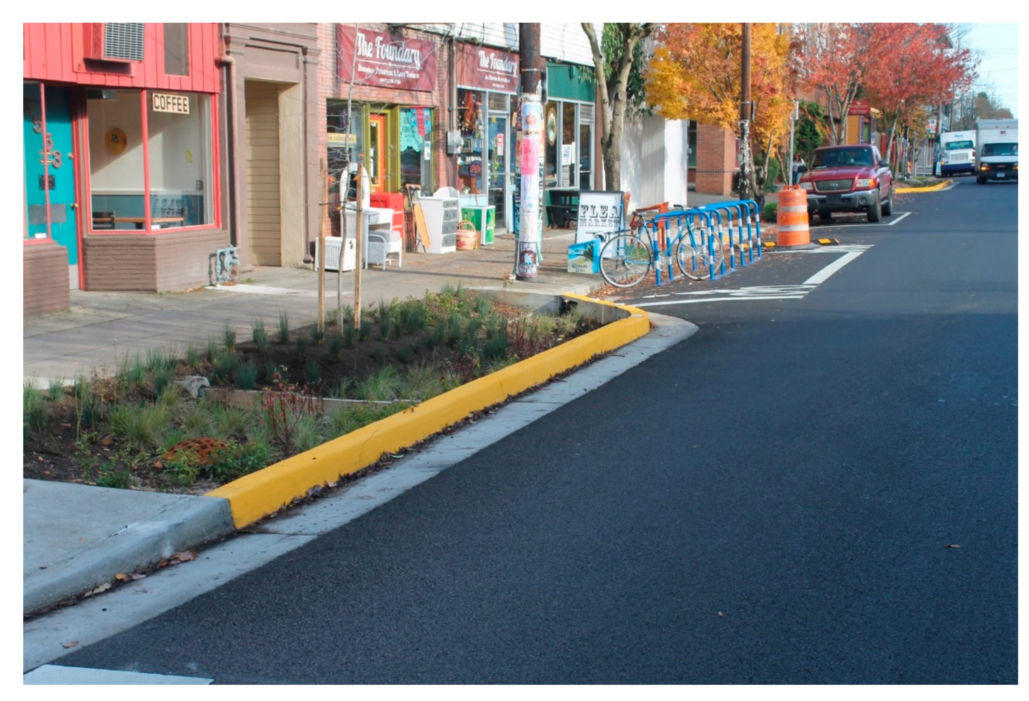
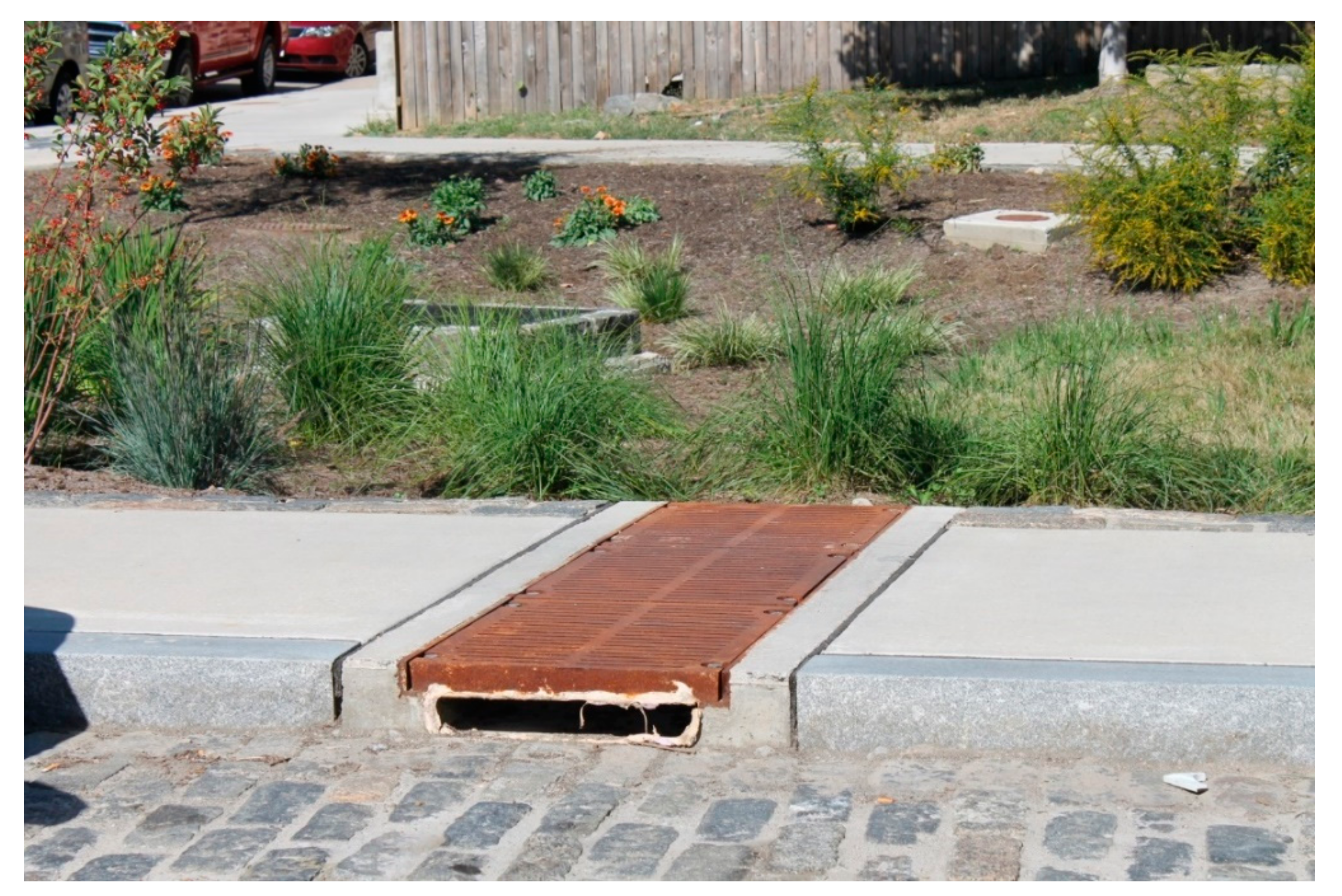
Figure 1,
Figure 2 and
Figure 3 present some of the on-site visits for visual inspection.
Case studies were selected based on the “similar to another and both least similar to a third case” approach suggested by George and Bennett [
60]. This approach allows us to learn from controlled similarities and differences. The cases were selected from the same country, with similar total annual average rainfalls, comparable areas, the same types of sewer systems, and with ongoing green street programs. Seattle, Portland and Philadelphia were selected from a list of 20 potential cities. Portland and Seattle, the similar cases, are both green streets pioneers in the US, and both are located on the Pacific coast. Philadelphia, in contrast, is a late implementer and is located on the eastern coast. In the end, over 100 documents and websites were reviewed and nine phone or in-person interviews were conducted in the three cities. This research is presented as parsimoniously and succinctly as possible here. The stakeholders interviewed were officials of environmental, transportation, utility, and planning departments, a delegate of the office of the mayor in Philadelphia, advocacy group members, academics, and practitioners (consultants). Interviews were recorded to be later transcribed.
4. Results
Early on in this research, when exploring potential case studies, it was evident that the common ground of early green street implementers in the US was stormwater management. All three cases (and many other cases explored in the case selection process mentioned in the methods section) were related with stormwater regulation. The story started in 1983, when the US Environmental Protection Agency (EPA) released a report proving that stormwater was not harmless [
61]. The EPA was especially concerned with the discharges of combined waters (stormwater and wastewater). These combined sewer overflows (CSOs) occurred during heavy storm events in cities, generating vast discharges of combined waters into the bodies of water. If combined sewer discharges were central in the debate, separate sewer discharges also were found as not harmless. In 1987, when Congress amended the Clean Water Act, local governments became responsible for finding ways to control stormwater to protect surrounding waters.
Different cities adopted different strategies. Besides the traditional alternatives (e.g., separating the sewer systems), the purpose of green alternatives is to provide permeable areas in order to mimic previous urban conditions in which the soil perviousness facilitated water retention and delayed runoff [
7,
62]. Green streets and green roofs are examples of green stormwater infrastructures (GSI) to retain or detain runoff, and thus reduce pollution discharges into US waters. By GSI, we mean rain gardens, bioswales, bio strips, infiltration planters, street trees, and all permeable areas that provide one or more environmental services.
Each case study has the same structure. First, there is a general introduction of the case with the story of how green streets came into existence locally. Next, the description focuses on the street planning and design process and how GSI was introduced within the ROW. Finally, for each case, the variables that each city took into account to develop their approach are presented, as well as the proposed process to achieve green streets. Here, for the sake of simplicity, the term “green street” refers to a street that contains green infrastructure even though it is sometimes used differently, for example in Seattle.
4.1. Seattle: The Pioneer
Seattle is an innovator in green streets in the US. The city is located in a populated region surrounded by a fragile and delicate estuary. The Puget Sound estuary, a rich ecosystem, faced continuous degradation that reduced the salmon population and diminished recreational appeal. Even before the EPA identified the problem, scientists in Seattle found that stormwater from urbanized areas highly contributed to that degradation [
63]. Yet, back in 1995, the effects of watershed urbanization on streams around the US were well documented [
64]. But at the time (in 1995), nothing concrete for green street implementation was available besides timid sentences in plans suggesting the idea of front-end solutions able to mimic pre-development conditions instead of end-of-pipe solutions.
Although there were earlier experiments with GSI in Davis, California, and Prince George’s County, Maryland, Seattle has the merit of initiating the first green street pilot project in the US. Called the Street Edge Alternative (SEA street) project, it involved the complete reconstruction of the street and its drainage system. The roadway was narrowed from 7.62 m to 4.27 m to create a meandering road surrounded by permeable green zones, including 100 new evergreens and 1100 shrubs, in the remaining 18.28 m of the ROW [
65]. The emblematic curb-free design allows water to drain into swales along the street edges. The project, completed in the spring of 2001, was designed to decrease the quantity of stormwater discharged into Pipers Creek [
66]. Besides meeting the Clean Water Act’s water quality requirements, decreasing stormwater quantities discharged into creeks was one of the main goals for the Seattle area, in order to prevent channel erosion and to enhance reduced salmon reproduction rates.
Pilot projects like SEA streets provided real performance data, which served for the planning and design of future green streets. Results were overwhelmingly good in hydrological, acceptance, and even financial terms. The hydrological performance estimation of SEA street was too conservative by far when designed. The SEA street could fully attenuate up to 19 mm of precipitation and has prevented the discharge of all dry season flow (10% of the yearly rainfall) and 99% of the wet season and overall runoff. The SEA street drainage performance increased in time, withholding more water from discharge as time went by [
67,
68].
The ROW allocation principles in Seattle are very progressive for the US and likely in other latitudes, as they explicitly consider the fulfillment of many functions in the street. The Right-of-Way Improvement Manual is Seattle’s reference for street design and states that “they [the ROW] must safely accommodate multiple modes of travel, offer universal access around and through the city, provide access to private property, enhance a place’s character, protect environmental resources, and allow for the delivery of utility services” [
69]. This manual contains the necessary information to design streets with GSI measures (hereafter referred to as green street, even though in Seattle the meaning of the term green street is different). This manual proposes two modalities of green streets: GI can be used as part of partial street improvements or as complete ROW retrofit. Partial street improvements usually include improvements to sidewalk and planting strip areas (
Figure 1). Full ROW improvements involve sidewalks, planting strips and full roadway width reconstruction [
70].
The procedure used to select the street to be intervened was not particularly strict. Seattle Public Utilities, the entity responsible for green streets implementation, wants projects in places that serve their stormwater objectives. The location of the projects within the city is determined with the drainage system and the sewer basins (combined, partially separated, or separated) in mind [
71]. Maps with the drainage basins show the zones of combined sewers, which are the preferred places for infiltrating stormwater. Once the zones had been selected for the pilot projects, with the protection of a specific creek as the objective, a neighborhood was selected; low traffic streets are the preferred location for such projects. However, since few projects have actually been completed in Seattle, it is not clear how a specific street is selected. The green streets coordinator at Seattle Public Utilities suggests some criteria for selecting the location of the block: first, that the type of soil on the block can infiltrate the water; second, that there is space available (opportunity to narrow the roadway or replace parking); and finally, that the community accepts the implementation [
72]. The Right-of-Way Improvement Manual enumerates the following factors to be considered when designing each GSI: native soil permeability, longitudinal and cross slopes, presence or absence of curbs, and space availability [
70].
Once the zone and street are selected, engineers then provide the street designer with actual sizes of the GSI to be provided. According to the water practice director at a specialized consulting firm in Seattle, the GSI is sized for minimum goals; for example, to retain 90% of the runoff or a fixed amount (at least the first 19.05 mm) [
73]. It includes the determination of the catchment area of each of these GSIs and, depending on the expected probable runoff for a given return period, the GSI facility designed. In practice, the manual also provides design standards for different types of GSI: conveyance swale, curb extension, tree planting within bioretention swale, and bioretention biofiltration cell with or without underdrain. Following this, the manual directs the designer to other codes and other technical documents for the sizing and design of hydraulic elements.
To complement the street design story in the city, Seattle has a Complete Street policy (ordinance No. 122386). The way in which both complete and green streets have been harmonized is through a street design checklist that gives extra points for GSI according to the Seattle green streets coordinator [
72]. But not every Complete Street project will necessarily have GI. Both the lack of space on busy streets and the Seattle Department of Transportation (DOT) budgetary priorities have brought green streets to be an exceptional outcome, not the norm. In main and arterial streets, where pavement and safety priorities are concentrated, space is scarce. An official at Seattle Department of Planning and Development, explains that attempting to force the inclusion of GSI within Complete Streets redesigns could result in subnormal designs, for example, “narrower than standard bike lanes, sidewalks” [
74]. In addition, the usage of permeable pavements and other alternative stormwater infrastructure is expensive. Seattle’s green streets coordinator states that the DOT has not had the money for stormwater management facilities within the ROW (bioretention and permeable pavements) or for their maintenance [
72].
4.2. Portland: Pioneer and Fruitful Implementer
Portland is a progressive city that has been at the forefront of many topics, and street design is one of them. Recurrently, plans and manuals reaffirm the importance of having streets beyond cars. The famous tram system and extensive bike network prove this strong tendency towards multimodal mobility. This multimodal approach existed in Portland prior to any Complete Streets policy or other influence. Already in 2002, the metropolitan regional government for the Portland area (METRO) published Creating Livable Streets, a guideline that explicitly acknowledged the incompleteness of the conventional mobility-accessibility street classification system of the American Association of State Highway and Transportation Officials (AASHTO) [
75]. It recalled the importance of considering all modes, 15 years before the city adopted its Complete Street policy in 2012. In Portland, balancing the multiple interests that use the ROW is important [
76], and those interests can go beyond transportation.
Portland’s development of green streets began early in the 2000s and has more than 1200 operating GSI within its streets. Like any other city with combined sewer systems, in 1987 Portland faced federal requirements to manage stormwater. However, in this case, the city defined its stormwater strategy after a litigation process with an environmentalist advocacy group that pushed for definite solutions. As a result, in 1991, the city of Portland entered into an agreement with the Oregon Department of Environmental Quality (EPA’s designated authority) to control 99% of the combined sewer overflows in 20 years. At that time, traditional solutions were evaluated and the problem was approached by means of the construction of three big underground pipes to collect the mixed water during wet seasons to be stored and later conveyed to the wastewater treatment plants. However, due to technical and budgetary reasons, the biggest pipe was downsized, requiring alternative solutions. After the success of rainwater infiltration in the roof disconnection program and experimentation with green roofs and other GI, the city started a green street pilot from 2003 to 2007 that included several street interventions. Green streets emerged as this alternative to fulfill the requirements of the agreement. A Cross-Bureau Task Force, a program launched in 2005, led to the enactment of the green street policy in 2007 (passed by resolution) [
77]. The program was a temporal effort aimed at creating a programmatic approach, which would make GSI possible in street projects wherever feasible [
76].
Portland issued many different plans and manuals to support the development of green initiatives: Green Spaces Master Plan [
78], the Best Management Practices Manual [
79], Creating Livable Streets [
75], Green Streets Handbook [
80], and the Stormwater Management Manual (SWMM) (first in 1999 and updated in 2003, 2008, 2014, and 2016). Out of this set of documents, two deserve special mention. The 2002 Creating Livable Streets manual was a visionary document published by METRO that provides general and descriptive design guidelines of GSI in the ROW. However, this idea was never developed or updated with qualitative and technical information. In contrast, in the 2003 version of the SWMM, a set of green street design minimums was defined. The SWMM is fundamental because it contains the stepwise procedure used to design green streets first introduced in the 2008 version. In 2006, the Drainage Manual was updated (to replace the 1991 Sewer Design Manual) and it currently considers green infrastructures as a legal element for treating stormwater. The SWMM, issued by the Bureau of Environmental Services BES (not by the DOT), became the primary reference manual for managing stormwater from public and private areas, and designing water quality facilities and storage structures for managing stormwater flows [
77].
The green streets design comprises nine steps summarized in
Table 2. The process has evolved and the manual currently explains, in a clear but technical fashion, a complex and comprehensive design process. It begins by evaluating the condition of the project site, which is derived from a regional or citywide analysis. Step 3 considers an analysis of the GSI project in the current stormwater urban system, which implies revising at all scales (from the city scale to the street scale). Steps 4 and 5 are dedicated to details of the local street design. Several steps (e.g., 2, 7, or 8) represent procedural or legal requirements. Many steps direct us to other documents, for example, to the Sewer and Drainage Facilities Design Manual, to appendixes with technical information, and to calculators (worksheets).
Like Seattle, the Portland case has no clearly defined procedure for selecting locations of projects within the city. Nevertheless, there are some criteria. The first is the soil’s infiltration capacity at the desired location. For example in Portland, most projects are on the eastern side of the Willamette River where soils are very forgiving, compared with the eastern part. A Green Street Program official at the Bureau of Environmental Services (BES) in Portland, was interviewed for this study. She stated that another criterion for selecting a street for GSI is sewer network capacity. Congested sewers produce backflows in basements during heavy rain events. By modeling the sewer, points where the sewer is congested can be identified, and GSI installations upstream from congested segments within the sewer basin prevent runoff from entering the sewer (
Figure 2). An example of this is the “Tabor to the river program.”
Once the zone of the city has been selected, the choice of a specific street depends on the availability of space, or in other words, the amount of the right-of-way that is not devoted or assigned for a specific use. A former official and a hydraulic engineer at BES agreed that green streets in Portland tend to be low traffic volume streets [
82]. The engineer pointed out that more projects should be located within arterial roads because most pollutants settle there. The former BES official is convinced that GSI can be added to busy streets if they are carefully designed. He points out the advantages that there would be if more stimuli and funds ever become available for retrofitting these roads.
As a current Green Street implementer with a high number of constructed works, the Portland experience serves as an example. Two major elements have been identified as key factors in the fruitful implementation of green streets. The first is the simplification in the exception process for alternative designs, i.e., making it less tedious and risky for officials in terms of professional liability. The second key point is the development of a clear, simple, and standardized procedure for designing (sizing), testing, and constructing green streets. The pilot project process in Portland strongly contributed to developing a straightforward design method. The key was the monitoring and testing of constructed projects, which provided real and accurate information with regards performance.
Table 3 shows the performance figures of five green street pilot projects. As a remarkable result, the “sizing factor” arose as the ratio of the facility area over the drainage area. In this way, an estimate of the size of the planter or garden can be easily calculated (e.g., 6% of the drainage area), providing orders of magnitude. Dimensions, materials, types of plants, locations, etc. of different projects were compared to achieve state-of-the-practice in design. Pilot projects were also educational for professionals for different agencies and they helped to explain the possible barriers and difficulties for a large-scale green street program.
The strategy used to overcome the transportation dominance of the ROW was multidisciplinary work according to the former BES official in Portland [
84]. In Portland this was possible after years of inter-agency work by, for example, the Sustainable Infrastructure Committee and the Cross-Bureau Task Force. A frank debate among distinct disciplines brought interesting ideas, where green stormwater solutions could have initially emerged. Portland’s former official considers that it was fairly easy to break the mono-functional thinking of transportation professionals by using the following logical thinking: 1. Portland has stormwater problems; 2. there are regulations and the city has to comply with them; 3. we are all in the same city and we were appointed to solve these problems; 4. we need to do this in streets because the city does not own lands. At the end, he stated: “They are engineers… they are trained to find solutions to problems” [
84].
4.3. Philadelphia: A Systemic Approach
The process in Philadelphia was different. Rather than a formal green street program, green streets are just one of the city’s eight strategies to transform the city into a “green machine.” The program, known as Green Cities Clean Waters was launched at the very end of the first decade of the 2000s, almost 10 years after the first green street was implemented on the west coast. Its objective is to manage stormwater to solve the CSO situation in the US by means of GSI. The approved Green City Clean Waters plan requires the city to manage the runoff of nearly 40 square kilometers (10,000 acres) of impervious surfaces, at least one-third of the impervious area served by Philadelphia’s combined sewer system [
85,
86]
In 2008, after a decade of approaching CSO problems with palliative actions, the city was required to adopt a strategy to substantially reduce CSOs. After a series of studies, the city decided to manage stormwater through a massive greening program of schools, public facilities, parking lots, parks, industry, business, streets, alleys, and homes. An example of GI implementation in a former parking area is shown in
Figure 3. The green stormwater plan is a 25-year program in which the Philadelphia Water Department (PWD) will invest approximately
$2.4 billion (
$1.2 billion in 2009 dollars) [
85].
During the first decade of this century, PWD was leading an inter-agency, multidisciplinary process to address water quality problems together with municipalities and counties that share one or more watersheds with the city. Since 1999, Philadelphia has established partnerships with six neighbors (counties and cities) to develop an Integrated Watershed Management Plan, which operates under a three-phase structure: (a) preliminary reconnaissance survey, (b) watershed assessment and planning, and (c) watershed plan implementation [
87]. Simultaneously, the city of Philadelphia evaluated five different alternatives including green and gray infrastructure in light of the experiences of other cities, including those using GSI, facing the same problem. According to a former Director at PWD, a systemic decentralized green stormwater alternative with limited additional gray infrastructure to reduce CSO ranked first among the five alternatives [
88]. It was determined that the green alternative provides maximum returns of environmental, economic, and social benefits within the most efficient timeframe, making it the best approach for Philadelphia.
The Philadelphia case is especially important in the green streets design process described in this study because its comprehensive analysis of the situation brought the importance of greening cities beyond pure stormwater management. The specific results of the Stratus Consulting report showed that green solutions provide such a vast and varied set of benefits (social, economic, and environmental) that the green scenario is unbeatable by any other option [
89]. For example, the study showed that in a scenario of 50% runoff served by GSI with a large underground storage tunnel handling the remaining 50%, the benefits from GSI surpassed
$2.84 billion from 2009 to 2049 (in 2009 US dollars), while the benefits from the tunnel only reached
$120 million [
89]. Surprisingly, the benefits in water quality improvement rank third on the list. Heat stress mortality reduction (accounting for 37%) is in first place followed by improved aesthetics and property value (20%). In third place, accounting for only 12% of the benefits, are increased recreational opportunities and water quality and aquatic habitat enhancement [
89]. These results bring the discussion to a tipping point, since the main benefit of green streets in Philadelphia is not stormwater management.
Green streets are a major component of the Green City Clean Waters plan since the city’s street network is its most abundant asset for reaching its goal. In Philadelphia, the target (based on models and simulations) is to provide at least some green elements on 50% of the 4465 km (2775 miles) of roads by 2028 [
86]. The goal is to manage 25.4 mm (one inch) of runoff onsite, relying on green infrastructure for billions of gallons of required sewage overflow reductions.
What is the local design procedure? The Department of Streets (in the Office of the Deputy Mayor for Transportation and Utilities) and the Water Department worked hard to compile the design standards manual to accommodate green street elements, for street typologies that represent typical conditions in Philadelphia. As background, the Department of Streets issued the Complete Streets Handbook beforehand in 2009. The Complete Streets Handbook is a supplement to existing design codes, and considers the existing design codes and the Bike and Pedestrian Plan. Although the Complete Streets Handbook mentions the stormwater plan and the green streets movement, it does not even consider in its design procedures any functional green infrastructure. It barely mentions that wider ROW, like the planted strips along some of the city’s 418 km (260 miles) of state and federal highways, offer opportunities to naturally drain stormwater runoff and incorporate bike lanes [
86].
The Green Streets Design Manual defines a complete procedure for the design of green streets with “the primary goal of implementing GSI is stormwater volume reduction.” It starts first by presenting a menu of GSI options available to be implemented (types of GSI): street trees, trenches, pump-outs, planters, permeable pavements, green gutter, and drainage wells (all for stormwater infiltration). The so-called sustainability matrix considers the seven types of GSI and the 11 types of street. For each cell of the matrix, the manual suggests whether a certain GSI type is suitable, possible, or not recommended for a given street type. For the most frequent type of streets, with low traffic, local, and residential, all seven types of GSI are suitable.
The manual defines a four-step procedure for designing a green street:
- (1)
Identify potential streets where GSI can be implemented based on existing conditions. Here, streets are screened by gradient or conflict with existing utilities.
- (2)
Identify the street’s typology according to the Complete Streets Handbook.
- (3)
Consider potential GSI type for each selected street according to the “Sustainability Matrix.”
- (4)
Choose the most appropriate GSI.
5. Green Street Design and Implementation
Unlike the traditional street design process, green streets require complex, multi-scale, multi-agency, interdisciplinary, stepwise processes. Thus, when speaking of implementing green streets, the word “design” should go hand-in-hand with the word “planning,” as long as each GI installed is part of an overall strategy to reach a goal.
Out of the three cases, three main steps were identified for green stormwater infrastructure in rights-of-way: first, a large-scale environmental system analysis; second, a meso-scale assessment to analyze the needs and suitability in different areas within cities; and third, a local-scale street design process (
Figure 4). Despite the fact that the three cities have undergone their own independent processes (see
Table 4), the same scales proposed by Norton et al. [
9] have been evidenced in the case studies presented. In terms of green street planning and design, Portland, Seattle and Philadelphia started with a large-scale (city/basin) systemic analysis. In Seattle, this work was carried out by ecologists and environmentalists who studied the declining environmental condition of the Puget Sound Estuary beginning in the 1980s. In Portland, they used this regional approach to understand both problems and potentials. In Philadelphia, after developing an understanding and diagnosis of the problem at regional level, citywide modeling and simulations were carried out to evaluate the most suitable solutions. The results obtained in the first step are an input for the following steps (meso and local scales) and are required only once.
The second meso-scale stage, probably the least well-developed of the three, deals with site selection including both the zone within the city and the specific streets upon which to locate the GSIs. Sewer deficiencies, combined sewer system zones, areas with good soil permeability, and sewer basin backflows due to congested sewer lines were some of the reasons used to explain decisions in these cases.
The third stage includes three separate activities: finding space within the ROW, selecting the GSI typology, and the traditional transportation-landscaping design. Depending on space availability, different GSI typologies can be installed. The decision is a matter of performance, costs, and available space. According to Gallo et al. [
90], a simplified design method makes it easy for designers with poor experience in hydraulics to incorporate GSI into streets. Portland is a good example as they created the sizing factor, which has contributed to easy approximation of size by professionals in other disciplines (but not replacing the technical hydraulic design for each facility itself). The construction phase take place following the local scale design.
These previous processes imply complex institutional interactions, a systemic view of the problem, and multidisciplinary work. We found that the planning and design of green streets implicate various federal, regional, and local public entities, besides the DOTs, including the EPA and the local environmental, water, and utility departments. However, the local DOTs still play a paramount role in this complex process.
6. Discussion
The engineering design process by Nigel Cross [
91], points to the importance of fully understanding the “problem definition” and to develop a “conceptual solution”. Following this, clear functions of the object to be designed have to be defined. For almost a decade, Seattle and Portland worked hard on these two tasks; the keystone of green street design. The SEA street project in Seattle served as the initial credible evidence of the effectiveness of green streets for stormwater management. Experimentation determined the features of different GI technologies (ponds, bio swales, trenches, etc.), and performance rates. Philadelphia had a much shorter problem definition period and conceptual process, given that the technologies had already been defined before.
The large-scale analysis serves to determine the overall demand of GI (e.g., in the watershed) and some relevant citywide characteristics for the design, such as precipitation, imperviousness rates, infiltration rates, or sewer performance in different city zones. Conversely, demands for traditional street designs (e.g., traffic demand), are not accountable for the entire city, but rather estimated more locally (e.g., corridor). Recall that traditional design practices usually consider traffic volumes and infrastructure capacity (for different transportation modes), road safety, aesthetics, or other variables, which can be resolved at local/corridor scale.
The meso-scale stage is the least developed of the three stages. Worthy of note are the contrasting points of view of interviewees regarding the most suitable type of road (locations) for constructing green streets. Should green streets be located on low-traffic roads, busy streets, or both? Streets with low volumes of traffic seem to be the right location for GSI, since there is more space available for reallocation. In general, such streets account for the vast majority of city road networks. This type of street in the US is characterized by generous rights of way [
92], by oversupply of parking [
93], and by a desire for traffic calming to enhance livable areas. In addition, the literature suggests that green infrastructure should be located close to people, as benefits can be attained by mere proximity to green infrastructures [
31]. On the other hand, interviews with the Deputy Water Commissioner of the Philadelphia Water Department and the director of environmental services (DES) on Gresham, Oregon [
94] provided reasons to locate green infrastructure in busy corridors. The DES director pointed out that locating the GSI on busy roads would do more to reduce the discharge of pollution into rivers than locating it on quiet streets since most pollutants come from vehicle operation. In addition, people tend to walk along busy roads, highlighting them as places where people would benefit most from green streets [
94].
A concern in the lower-scale analysis deals with developing a standardized manner for finding spaces within existing consolidated streets for GI. Different strategies become feasible depending on the hierarchy of roads selected in Stage II. These include the narrowing of vehicle lanes, reclaiming underutilized pavement, conversion of borders, furnishing zones, and traditional landscape areas, and eventually substituting parking boxes to function as GI. Overall, the interviewees agreed that it is important to maintain (or affect at the minimum) the street performance and services provided by the street before the addition of GI. Tackett [
95] reinforces this idea when she suggests that an implicit design rule should be to ensure a similar service for motorists as in original designs while accommodating infiltration swales. One of the most sensitive topics is parking. Any change in the amount of space devoted to parking could generate opposition to green streets. The principle this implies is that GI should be built “at the edges of the right-of-way.”
Street design has been experiencing ground transformations in recent years. One of these changes is due to the evolution of street functions; a process that began in the transportation field with a broader understanding of the street, beyond movement for cars. Under a new mobility paradigm presented by Banister [
96], he supports the idea that a much broader notion of the street is needed, where streets are no longer considered mere roads but also as spaces for people, active modes, and public transport. In the environmental field, little has been reported in the context of street design with regards environmental functions. This paper provides empirical evidence of the effect in street design of the environmental function of the street introduced in the past by Hui et al. [
97] and other authors [
98].
It is important to remark that neither multi-modal street designs nor green streets come from the self-evolution of traditional street design. Both movements, multi-modal streets and green streets, succeeded quite independently in breaking the rigid code-based, transportation-focused street design. Both movements proved that a well-defined, understandable, and sharply focused workhorse is a strength that increases power and that allows goals to be reached more easily. This workhorse is safety for complete streets and, in this case, stormwater management for green streets. Transportation officials and policy-makers, who are more concerned with the right-of-way, are more likely to be motivated to change if the problem is framed as one that the city or society cares about: safety and water quality.
GI provision in several US cities has been rooted in stormwater management, especially in those with combined sewer overflows. For this initial group of green street implementations in US cities, the workhorse was stormwater management. Since new GI in cities can produce other benefits, the workhorse can potentially involve many other aspects, such as public health (improved air quality), property damage prevention (flood control), or the reduction of heat wave mortality (for urban cooling). In terms of design, the citywide analysis and meso-scale step are required to define the overall amount of GI required and to efficiently allocate that infrastructure within the city.
Paradoxically, the insertion of green infrastructure within the ROW, instead of harming or diminishing the movement function, might strongly benefit pedestrians and cyclists. These modes, also known as active modes, are important within the urban transportation strategy for sustainability. Evidence suggests that there is a causal effect between tree planting and cyclist satisfaction [
99,
100]. Another transportation-related benefit provided form bio-swales installed next to intersections, is that the crosswalk distances for pedestrians can be shortened, reducing risk exposure, while slowing traffic down.
GI in streets provides many other benefits beyond stormwater management, making green street programs an attractive option in working towards sustainability. In practice, cities in the US might still have a partial or incomplete grasp of the concept, beyond stormwater management. In other countries, the lack of incentives and dissemination to policymakers can be reasons for the limited implementation of green streets in many other countries. The case of Philadelphia shows that a mono-target green streets program (for stormwater management) is not actually accurate when evaluating a massive green streets program, as long as many other important benefits of GI are not considered. This paper contributes in the practical scope by summarizing these benefits (addressing other environmental functions of green streets) and expanding on the practical design process.
7. Conclusions
Literature and the empirical evidence have demonstrated the convenience of providing GI in cities. GI requires physical spaces and the actual implementation of GI in cities has been proved to be difficult and challenging, especially in finding areas to be devoted to that end. Streets have been found as a convenient location for GI in urban areas. Based on three cities in the US that advanced in the planning, design and implementation of green streets, this paper explored the green streets processes and reported the evolution of the traditional street design routine.
The main outcome of this research is the identification of common elements in the design process among the case studies. The green street design process includes various steps and addresses different issues at different scales; it is a complex, multi-scale, multi-agency, interdisciplinary, stepwise process, that requires a longer time frame and the development of a specific legal framework. We have found that the word “planning” appears necessarily attached in the green street design process. A framework for a green street planning and design procedure was presented and discussed in the paper.
This paper contributes to enriching the discussion and reporting cases with actual green streets. The street design process reported, guided by the stormwater management approach, is a confirmation of the existence of the environmental function of the street and confirms the ROW allocation conflict. At the same time, this study provides a glimpse or a sense that there is a substantial amount of underutilized space within ROW, which can be optimized through careful multifunctional design. The cases show that there are possible ways to allocate spaces within the ROW, without reducing the capacity or diminishing the level of service for other traditional street uses.
As final recommendations, cities can explore the transformation of current ROW into green streets as a smart way to deal with many current problems or situations (e.g., the deficit of green areas or adaptation to climate change). Since qualitative research is interpretive and contextual, it is suitable to describe phenomena rather than provide conclusive results. The presented planning and design process associated to green streets, rather than providing an applicable method, should be seen as inspiration to guide similar processes in other cities, learning from the good and the bad experiences of the three cases presented.


