Article

Defining Natural Landscape Qualities of the Southern Part of the Krka National Park in Croatia

1
Green Infrastructure LTD, 10000 Zagreb, Croatia
2
Department of Ornamental Plants, Landscape Architecture and Garden Art, Faculty of Agriculture, University of Zagreb, 10000 Zagreb, Croatia
*
Authors to whom correspondence should be addressed.
Sustainability 2021, 13(23), 13485; https://doi.org/10.3390/su132313485
Submission received: 12 November 2021 / Revised: 30 November 2021 / Accepted: 2 December 2021 / Published: 6 December 2021
(This article belongs to the Special Issue The Role of Landscape Perspective for Environmental Management)

Abstract

:
The paper is based on a review of the established principles for evaluating the natural qualities of landscapes and developing procedures that can contribute to current methods, upgraded with indicators derived from the perception and attitudes of the public. They were implemented into an integrated model of natural landscape qualities. The method included modeling of the natural landscape qualities for the southern part of the Krka National Park in Croatia. The first evaluation model was based on a survey whose responses were processed and classified using the AHP method and GIS. The results showed that the respondents recognize the diversity of land cover and relief forms and the degree of their fragmentation as the highest natural landscape quality. The second step included overlapping the vulnerability model of natural landscape qualities and the model of perception of natural qualities. It was found that the implementation of perceived natural qualities in the evaluation process affects the model of vulnerability of landscape quality. It also indicates the possibility of implementing the perceived natural qualities of certain landscape types into the complete landscape evaluation process, which encompasses all values in the space, including human perception. Therefore, the whole procedure pointed out the importance of the implementation of perceived values into landscape evaluation, something which is also emphasized by the European Landscape Convention (ELC).

1. Introduction

The starting point for researching the natural landscape qualities came from the ingrained understanding of the landscape purely through its aesthetic values. However, if we want to comprehensively explore the background of landscape value, it is necessary to synthetically interpret the natural and cultural-historical factors of the space (not only what people see but rather what is experienced with all senses). As one of the fundamental values of landscape, naturalness is defined as the preservation of natural elements (the level at which the landscape is spatially perceived as originally natural, taking into account how natural landscapes can be ecosystems subsequently introduced into space and left to succession) [1]. Park [2] defines the natural landscape as the so-called wilderness in the sense of nature “consisting of plants, animals and landscapes, in its primitive state, without human intervention”. Today, such areas are rare, since even the most natural ones are defined as such mostly due to management that excludes or even prohibits any or most of the physical interventions. Landscapes, by their definition, are areas of interaction between natural and human factors, and in many planning and management documents of protected areas, landscape quality is classified as a fundamental phenomenon of a protected area [3]. One of the theoretical starting points in this paper is the concept of landscape character. This is defined as a specific combination of certain natural and cultural factors that constitute a landscape as a formation that builds a unique, recognizable and consistent pattern of elements and making a given landscape different from one another (rather than better or worse) [4]. In terms of identification, analysis, and evaluation of landscapes, landscape character assessment is now accepted at the international level, which includes the identification, mapping, and description of landscape units of different characters and the assessment of their condition and sensitivity. The landscape character identification approach has an emphasis on clarifying what makes a particular landscape area different from another and can have more of an influence on objective, transparent, and professional decisions about their future [5]. It also provides inputs for land use and landscape planning decisions [6]. The landscape character assessment (LCA) starts from the mapping of landscape units, which can be carried out on several levels depending on the scale of the landscape and the type of project [6,7]. It is carried out by synthesis analysis of a series of cartographic data and application of the principles of landscape character consisting of the previously mentioned combination of natural and cultural factors (i.e., a specific combination of relief, geology, land use, spatial patterns of fields and settlements, soil, geology, and vegetation). Such an approach points to the state and quality of the landscape in order to preserve and to manage appropriately identified landscapes [6]. The aim is to point out the inseparability of natural and cultural factors in the formation of the landscape, especially since they are under constant alteration which can impact protected areas (the main area of research in this paper) [7]
The paper is based on the comprehension of the natural qualities of landscapes and on the potential approaches to their determination. Despite the specific combination of the natural, cultural, and visual qualities of each particular landscape, it is still often observed exclusively through its visual qualities, which neglects the natural and cultural aspects of landscapes. On the other hand, when determining the criteria for classifying natural qualities, the question of defining naturalness and its prevalence in the landscape arises. In many examples of professional papers, the notion of naturalness in the landscape is reduced exclusively to the aspect of bio ecological values (species and habitats), which does not include human perception of space and its values as one of the basic principles of the European Landscape Convention. This shortcoming in the holistic approach can be resolved by including the preferences of the respondents in the process of landscape evaluation, and by implementing the obtained results into the procedures of planning and protection of landscape values. Knowledge of landscape values is important for easier identification of goals that would be implemented in spatial solutions (and thus improve the process of land use planning and environmental management) [8,9].
The aim of the paper is to identify possible approaches in evaluation procedures and the possibility of implementing different qualities into landscape modelling. The starting point is that the natural qualities of the landscape are an integral part of its character, and that their identification is necessary for the sustainable development, protection, and management of both the landscape and all of those who use a certain area. Based on the analysis of relevant materials, the following working hypotheses were set:
  • Given the diversity of land cover and relief forms, the respondents will perceive landscape types in the area of the Krka and Čikola river canyons as more natural;
  • Landscape types with water element will be perceived as more natural by the respondents;
  • The implementation of perceived natural qualities of certain landscape types in the evaluation process affects the model of vulnerability of landscape quality.
Based on theoretical premises and a set of working hypotheses, the main goals of the paper were to determine the classification of landscape types with regard to the perception of their natural qualities, and to identify possible procedures for the implementation of perceived natural landscape qualities in the evaluation process.

2. Theoretical Starting Points and Overview of Previous Research

2.1. Defining Basic Concepts

2.1.1. Landscape

A landscape contributes to the creation of local cultures and is a fundamental component of European natural and cultural heritage. It is important for the well-being of the individual and society and its protection, and its management and planning impose rights and obligations that form an integral part of people’s quality of life [10]. There are numerous definitions that try to explain the term landscape. The definition from the Convention on European Landscapes, adopted by European Commission in 2000 and ratified by the Croatian Parliament in 2002), defines the landscape as an area, as perceived by people, whose character is the result of the action and interaction of natural and/or human factors (in Croatian translation is a specific area seen by the human eye). McHarg [11] defines the landscape as a “system of ecosystems” focused on the natural qualities of the landscape, which he defines as intrinsic values (i.e., those that are values per se; they do not depend on anything but themselves and cannot be associated with other values). Following this definition, Brunetta and Voghera [12] describe the landscape as a “structure of relationships between different systems” (geomorphological, ecological, environmental, cultural-historical, aesthetic, socio-economic, spatial) involving all genetic, biological and functional relationships within elements of the land cover, with the aim of pointing out the need for innovation in the approach to landscape interpretation and decision-making system. Landscape can also be defined as a completely perceived (seen) physical appearance of total phenomena on a small area, which was created by natural forces and processes or the interaction of natural and anthropogenic processes (i.e., human activities in nature) [13]. But there is also a difference between the physical description of the landscape and the social perception of the landscape, since the landscape is not just a space and is not an objective thing; it is an expression of the perception of space that people share, value, and use [14]. From the sociological point of view, the landscape as a term implies its dual character: firstly, as material objective structure in space, and secondly, as a subjective, culturally determined form of perception and evaluation of the same material structure [15]. Therefore, the landscape is not only part of the territory or part of the environment or part of space, but is a complete spatial phenomenon with its qualities as well as subjective and objective attributes that change due to changes in human activities in space [3]. Landscapes can also be seen as layers of various meanings and interpretations [8,16]. The landscape should therefore be approached as a complex system of different elements which, through their consequential connections, enable its functioning. Landscape planning is focused on the preservation of landscape quality, and is aimed at harmonizing different values and interests in spatial development. Its basic principle is sustainable land use planning and management based on an understanding of the combined human and natural processes in space [11]. These definitions indicate the importance of natural elements and processes in shaping the character of the landscape, but also the need to include human perception of space, as an integral part of its dual character, in the procedures of describing and evaluating the landscape.

2.1.2. Public Participation

Public participation enables the implementation of new knowledge, values and attitudes in the decision-making process and gives the authorities a better overview of the issues of the area, perceived by the public, with the ultimate goal of reducing conflicts that may occur in space [17]. This should not be seen as a substitute for standardized decision-making procedures, but as an addition since the opinions of all stakeholder groups can be taken into account. Previously mentioned ELC focuses on the human experience of the landscape, thus emphasizing the issue of landscape perception and character [18]. It also obliges to establish procedures for the participation of the public, local and regional authorities and other parties interested in defining and implementing landscape policies [10], striving to increase accountability and transparency in decision-making and strengthen public support for environmental decisions [19]. Public participation can become an integral part of identifying values through their mutual comparison among a number of interests and meanings. It can impact the generating of a number of alternative solutions and/ or scenarios [12]. This, in turn, leads to the development of paradigms that reduce the range of uncertainties encompassed by alternative solutions, which arise in planning. The real challenge is to develop “flexible” methods that can be used to quantify people’s opinions about a certain space, which can contribute to the creation of a number of alternative scenarios by encompassing a number of processes related to that space [20].

2.2. Review of Previous Research

The research of possible approaches has imposed the need to develop an approach to the landscape that takes into account its natural and cultural qualities and the ability to manage it sustainably. The basic assumption is that the description and evaluation of the landscape, considering the presented theoretical starting points, is not neutral and objective but is defined in terms of the given task [12].
On the other hand, perceived naturalness is the visual character of the landscape that respondents recognize as a certain degree of resemblance to nature. It depends on the respondent and as such does not necessarily correspond to the actual state of naturalness of the observed landscape [21]. The author states that the visual quality of the observed landscape plays an important role in experiencing nature, so the concept of naturalness can be observed by exploring how the observed landscape is equal to the perceived state of naturalness, taking into account that perceived naturalness may differ from actual naturalness [22]. The concept of naturalness is most often analysed in the study of landscape preferences and best describes the similarity between the perceived naturalness of the landscape and the actual state [18].
The basic principle for the classification and typology of landscapes that is today accepted and promoted is the principle of landscape character. It is determined by a specific combination of geology, relief, soil, vegetation, land use, field, and settlement patterns. Thus applied, the principle of character allows to define certain types of landscape; clear landscape units of relatively homogeneous character. Landscape type can occur in different areas, where there are always similar combinations of the already mentioned physical and structural factors [5]. Such an approach allows the use of information obtained to make decisions about the future protection, development and management of landscapes [23]. In view of the large number of factors and the diversity of data sources when harmonizing different criteria in the decision-making process, Feizizadeh and Keinberger [24] emphasize the importance of uncertainty in the final results. The authors therefore suggest the use of the AHP method [25] which reduces complexity by comparing pairs of individual criteria with each other and thus facilitates the ranking of variant solutions. Due to its simplicity, it is very often used in many analyses, among which benefit analysis, conflict management, and vulnerability analysis were conducted due to floods in the Salzach River Basin in Austria [24].
The landscape character assessment (LCA) was made within the LCA study of Krka National Park [5] whereby landscape units were mapped at several levels, which preceded the evaluation process.
Evaluation within the planning procedure implies, recognizes, and establishes a person’s relationship to the landscape [26]. Therefore, landscape assessment can be defined as a procedure that determines the values of a landscape and the basic elements and human perception in space that determine its main features. Value is defined through the quality of a particular object, and is determined through the relationship of a person or a particular social/stakeholder group in relation to an integral part of the landscape or the landscape as a whole [27]. Landscape assessment of space could also be characterized as a quantitative attribution of value with respect to a predetermined scale of values, while the attribute of the assessment would be qualitative attribution of values based on descriptive factors in space [3].
The evaluation method that can be used in the management of qualitative and quantitative parameters [28] is “modelling” that necessarily connects both parameters. In that way it solves problems of cartographic representation of subjective experiences of space characteristic within landscape analyses. Given that the landscape is a complex system of different elements and it is always necessary to simplify it for the purposes of analysis, it is considered that modelling is an adequate research strategy [29]. The model is an interpretation of an object, part of space, organizational structure from the actual world. In this case it represents reality (i.e., simplified and generalized spatial characteristics of the real world, its individual components, its different positions, shapes, and relationships) [30]. More specifically, the model is actually a representation of the environmental quality system and a tool for dealing with a complex system such as the landscape and human aspirations towards it. This is important in the context of planning, where relations are referred to the future scenarios, which in the present reality cannot be scientifically determined [1]. However, there is no measuring unit for determining the impact on landscape qualities and therefore there is no single way to evaluate it (in this case modelling the vulnerability of its qualities). The vulnerability model of landscape quality is one of the elements of dual spatial analysis. This is a method of protective planning, with its starting point in a systematic approach, for solving protective and environmental problems in spatial planning. Modelling the vulnerability of environmental quality means simulating the possible impacts of an activity on its quality. It provides an opportunity to assess the acceptability or unacceptability of the activity on the basis of a logical understanding (where the degree of quality is higher, the degree of acceptability of the intervention in space is lower) [1]. The vulnerability evaluation model represents spatial image of protective requirements.
In connection with the problem mapping the subjective experiences of space, there is an evaluation through social research. Whether the emphasis is on the object of perception or the subject who perceives the landscape, such landscape evaluation can be objective or subjective [31]. Objective landscape evaluation is mainly used by geographers, landscape architects, and landscape planners. Lothian [32] states that unlike the objective paradigm which “starts from the assumption that the quality of the landscape is contained in itself”, the subjective paradigm believes that quality can only be assessed “through the eyes of an observer”. Landscape evokes numerous associations that affect its subjective evaluation, and which are influenced by, among other things, the social and cultural context in which the observer lives, his/her experience, identity determinants, additional information he/she receives, perception of other objects in space, and connection with practical use (i.e., (im) possibility of realization of the perceived) [33]. Thus, from numerous definitions of nature and understanding of the way it manifests in space, it can be concluded that nature is not always directly suitable for valorisation, “measurement” and determining its total value [34]. The author also states the basic aspects of usable and unusable values of nature “as such”; the usable value of a natural public good is defined as the maintenance of existing ecosystems, microclimatic stabilization, biodiversity, etc., and could exist without human intervention. Unusable values “as such” can consist of: biodiversity, cultural and historical heritage, aesthetic values of nature, purity of the sea, values of the built and transformed environment, and values of natural and inherited habitat.

3. Materials and Methods

3.1. Research Area

According to the current Management Plan [35], Krka National Park covers most of the Krka River (75 km south of Knin all the way to Skradin) and its canyon. Parts of the Krka River were first protected in 1948, and gained legal status as a national park in 1985. The protection is based on geomorphological, hydrological, and landscape values, and consists of canyons, waterfalls, rapids, lakes, and travertine barriers as a fundamental phenomenon. Other values have been recorded, such as the originality of the animal and plant world, speleological objects, as well as the rich cultural heritage in the form of ethnological, archaeological and industrial heritage [35]. The entire Krka National Park is also protected as an area important for the conservation of endangered species and habitat types of the EU in the ecological network Natura 2000 of Croatia.
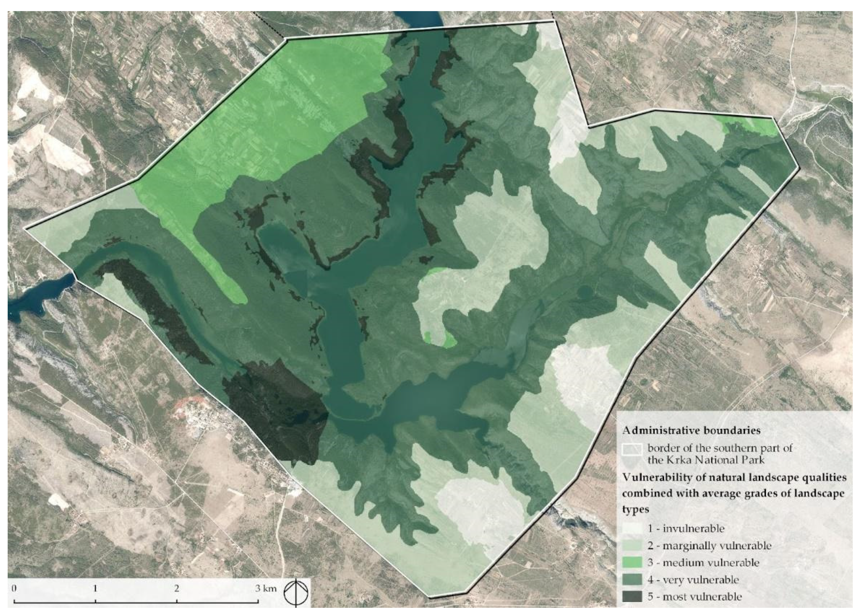
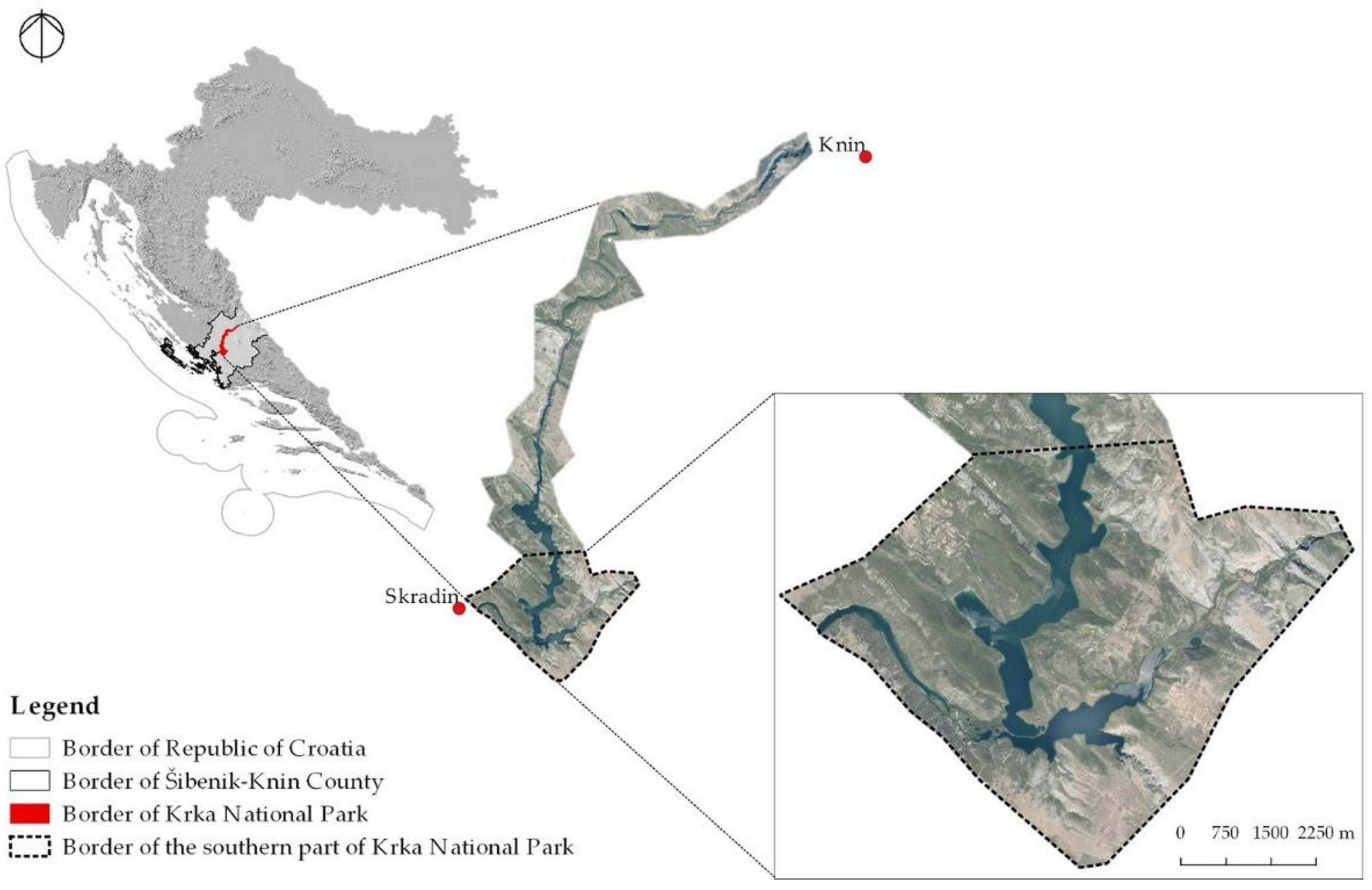
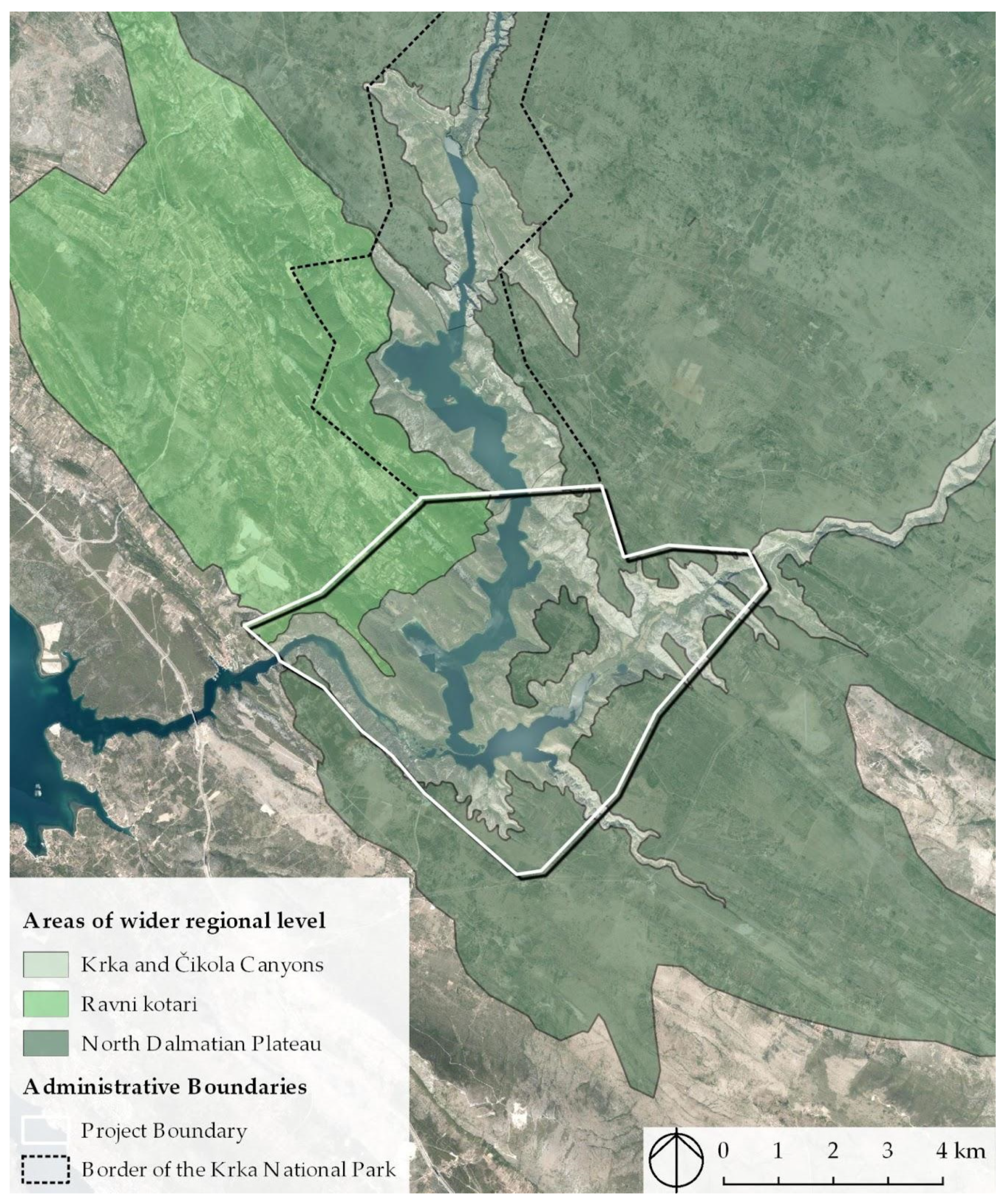
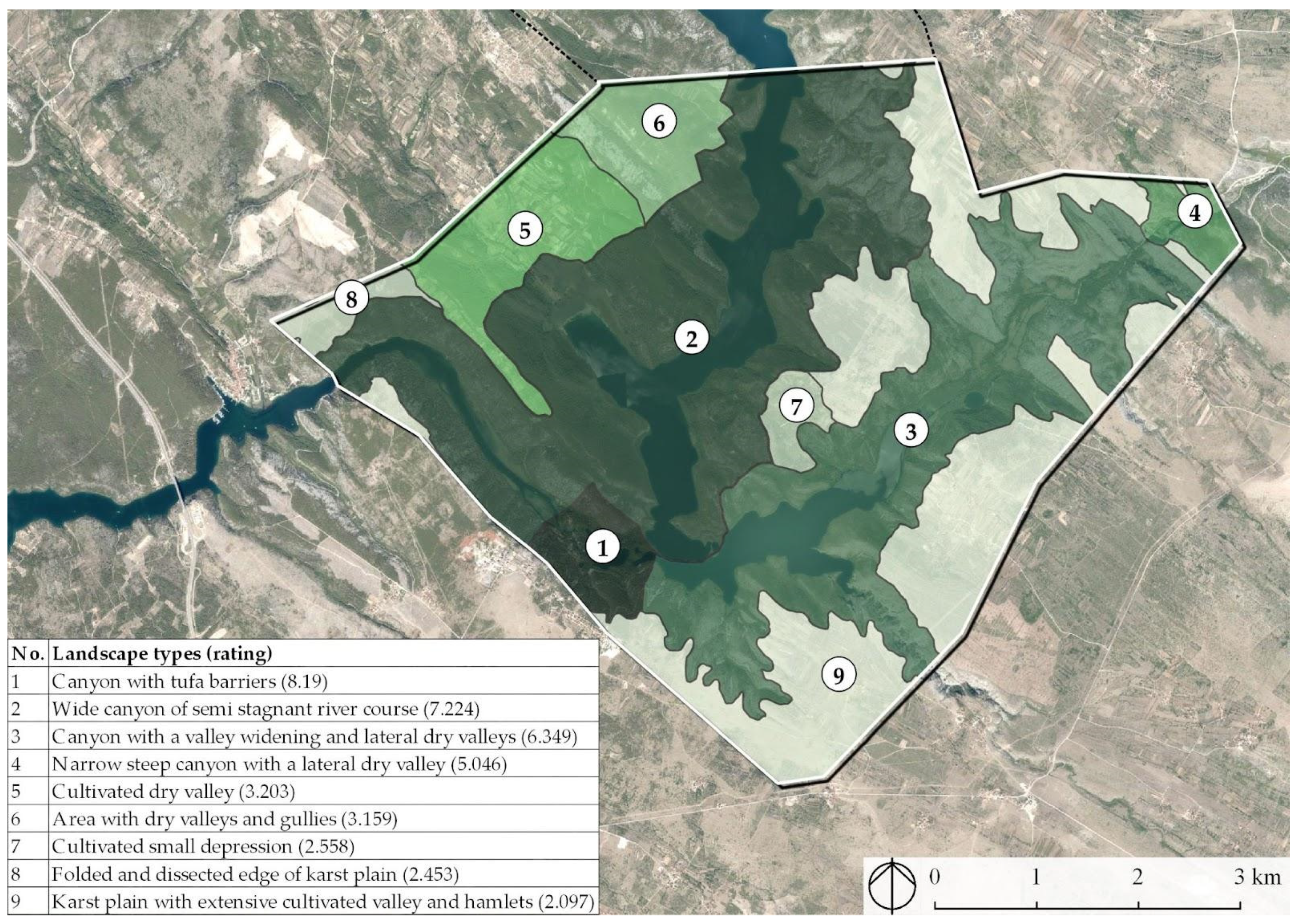
The selected area of the Krka National Park (Figure 1) includes the southern part of the Krka River Canyon (from Visovac Lake to the mouth of the Čikola River in Krka), the Čikola River Canyon from Gradina to the mouth, part of the Miljevci Plateau, North Dalmatian Plateau and Ravni Kotari. Therefore, it represents a diverse set of natural and cultural values of this part of Croatia. At the same time, this part of the National Park has very high landscape diversity and therefore was selected for this research. There are numerous significant natural sites here, but the most important are tufa barriers and Skradinski buk at the mouth of the Čikola River.

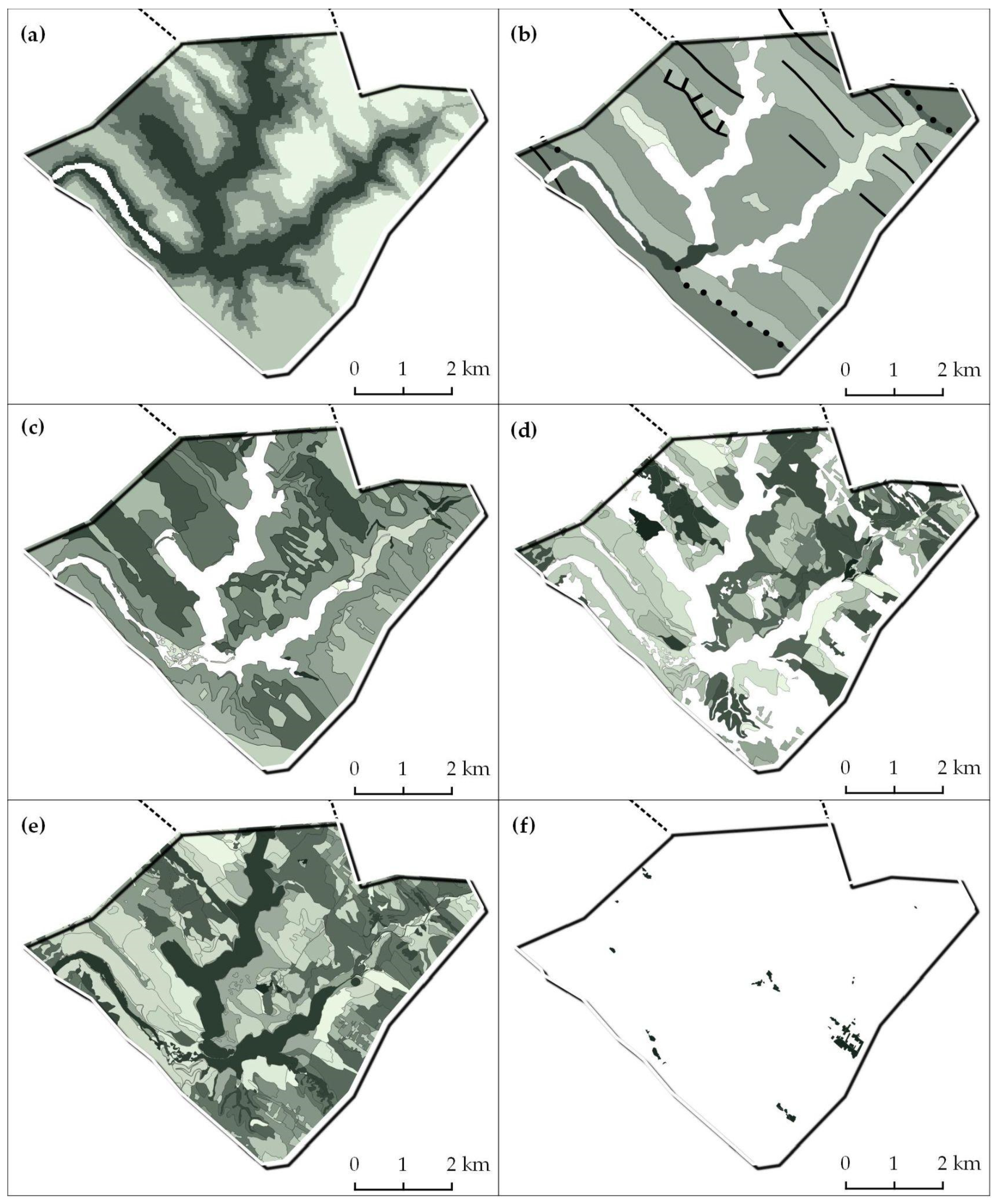
Landscape Characteristics

In the LCA, which was an integral part of the Krka National Park LCA study [5], multi-level landscape units were mapped, which Brunetta and Voghera [12] describe as parts of the area that have equal morphological, ecological, cultural (social and economic) characteristics. More specifically, landscape units consist of a specific combination of relief, geology, soil types, vegetation, land use patterns, and spatial patterns of fields and settlements (Figure 2).
Firstly, landscape types were identified. They are generic in a way that they can occur in different areas of the research area, and they always share a similar combination of factors. This is followed by the identification of landscape areas as unique and concrete geographical areas of a certain landscape type of unique character and identity, and whose distinction is determined by naming the landscape type through the corresponding geographical name or toponym.
The term landscape type has a generic meaning therefore landscape character type can occur in different areas of the territory, yet they share a similar combination of landscape elements. According to the corresponding landscape areas of the wider regional level (North Dalmatian plateau, Ravni kotari, and Krka and Čikola canyons) (Figure 3), landscape types of the Krka National Park area were generally classified (Figure 4).
Within the landscape evaluation process, landscape character is defined as a specific combination of natural and cultural factors of landscape formation. Certain landscapes are different due to their inherent, distinctive and consistent pattern of elements. Landscape character assessment starts by mapping landscape units that can be implemented on multiple levels and scales [4], and they represent unique spaces with the same landscape character at a specific location. Field studies are methods to identify landscape elements and their characteristics that in unique combinations create specific landscape characters [36].
The river canyons of the Krka and Čikola are landscape types whose variations depend on the relief characteristics of the canyon, primarily on the morphology of the riverbed and impacts on land cover, shores and soil, the presence of waterfalls, flow form, and land use. An important role in the current appearance of the riverbed is played by travertine barriers, which impact the upstream lake formation of the Krka River and the formation of river widening. Immediately before Skradinski buk, its largest tributary, the Čikola River, flows into the Krka River, with similar configurations and features. The bottoms of the Čikola and Krka canyons are generally very difficult to access, which is why they could never be a place of permanent settlements or more intensive human activity. However, canyon extensions, alluvial plains, and formed valleys enabled local agricultural use. In recent times, however, some canyon extensions and slopes are becoming more intensively used in agriculture, and to this day are used mostly in the traditional way in terms of fragmentation of plots and adaptation to natural conditions.
The undulating landscape of the valleys is mainly identified with the landscape characteristics of Ravni kotari landscape area. These are therefore relief-developed landscapes in which the characteristic change (in the direction of folding) is soil-rich and deep valleys and carbonate ridges, and variations of these landscape types depend on their size, land cover and land use. Fertility of the area and richness of water is a very important feature of the valleys, so unlike the surrounding karst plateaus, hills and mountains, Ravni kotari has a great agricultural potential. Throughout history it has always been an agricultural oasis of the Adriatic region and a factor in the development of surrounding cities.
The North Dalmatian plateau is a typical Karst plain developed on carbonate rocks. The main characteristics of the Karst plateau are poor relief dynamics, scarcity of fertile soil, and surface water. The extensiveness of agricultural activity has conditioned the almost complete cultivation of this seemingly natural landscape, which is now reflected in the high intensity and diversity of dry-stone fences and natural vegetation that represents the degradation stage of Mediterranean forest plant communities. Character of landscape types in the area of the North Dalmatian plateau, whose variations depend on the relief characteristics (i.e., on the degree of development of the plateau due to the appearance of Karst plain and variations of Karst depressions, land cover, and land organization and use) (Table 1).
Table 1. Classification of landscape types of the southern part of the Krka National Park.
Landscape AreaNo.Landscape TypePhotographs
Krka and Čikola Canyons1Canyon with a valley widening and lateral dry valleysFigure 5e
2Canyon with tufa barriersFigure 5f
3Wide canyon of semi stagnant river courseFigure 5d
4Narrow steep canyon with a lateral dry valleyFigure 5c
Ravni kotari5Cultivated dry valleyFigure 5g
6Area with dry valleys and gulliesFigure 5h
7Cultivated small depressionFigure 5i
North Dalmatian plateau8Folded and dissected edge of karst plainFigure 5b
9Karst plain with extensive cultivated valley and hamletsFigure 5a

3.2. Methods

After defining the starting points for research, information on the research area was collected. It was used for the preparation and making of spatial data. The following step was identification of the adequate approaches for determining the natural landscape qualities.
Then, the next step was to create a survey questionnaire. A survey was conducted on an appropriate sample of 20 undergraduate and 20 graduate students of landscape architecture to determine the respondents’ perception of the natural qualities of landscape types shown in the photographs in the survey questionnaire. The results of the research were then analysed using the AHP (analytical hierarchical process) method and GIS tools (QGIS (2.18 and 3.10.5 and ProVal2000). BPMSG AHP calculator <04.05.2016> was used to obtain the classification [37].
The AHP method, developed by Saaty in 1977 [25], was used for attributing values to given data. The data obtained by the process are divided into simple comparisons between the two criteria, which simplifies the weighting process and creates clearer and stronger evaluation criteria [38].
In the planning process, GIS tools are most often used to connect and simultaneously analyse different information and data. In landscape studies, this is predominantly applied in multi-criteria analysis within landscape evaluations since the subjective and objective aspects of space can be included simultaneously [39]. The spatial database used in this research was taken from the existing database of the Department of Ornamental Plants, Landscape Architecture, and Garden Art (University of Zagreb, Faculty of Agriculture).
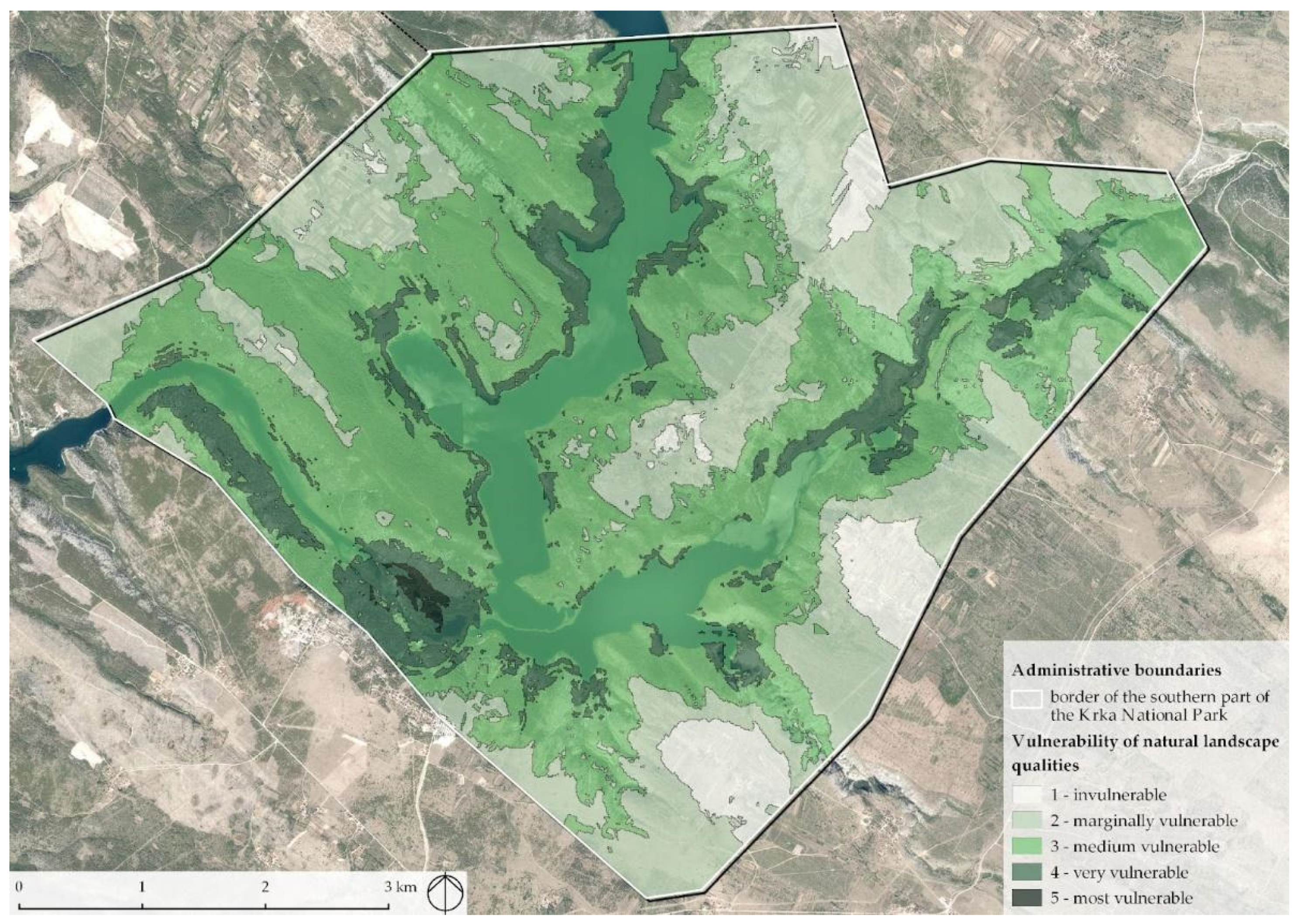
The results obtained using the AHP method were added as weighting factors when evaluating each landscape unit, thus obtaining a model of perception of natural qualities. Then, a model of vulnerability of natural landscape qualities was developed, after which the obtained models were overlapped in order to compare both approaches in determining the natural qualities of the landscape.

3.3. Examining the Perception of Natural Landscape Qualities

Čaldarović [34] wonders whether it is possible to determine the value of nature, and whether its values are measurable at all, regardless of whether it is a protected area of nature or nature per se. However, numerous studies have found that the value of nature can be assessed based on the perception of natural elements in space, and therefore use social research that focuses on perception.
One of the most commonly used approaches for determining naturalness is the comparison of the perception that respondents have about the natural values of a space and its actual natural value [40]. The analysis of scholarly research identified various concepts that can be used to explain how people perceive the landscape, and the author states that most studies have used the value of landscape as a habitat, biodiversity, ecological value, wilderness and naturalness, with the remark that the respondents most often determine the natural value of the landscape with regard to the biodiversity of the land cover [41].
In their research, Ode et al. [42] list three concepts that were used in this paper to select naturalness criteria, in order to determine the natural qualities of the landscape in the southern part of the Krka National Park. They are as follows:
1. Coherence: it refers to the unity of the landscape, the degree of repetition of patterns, colours and textures, as well as the relationship between land use and the state of natural conditions. The criteria used by Ode et al. [42] to investigate coherence are focused on the distribution of landscape elements in space, and are divided into (1) the position of the water element in space, which includes the presence of water and the relationship between relief forms and the water element and (2) vegetation allocation in space that implies a relationship with the expected natural state and fragmentation.
2. Complexity: it refers to the diversity and richness of landscape elements and the interrelationship of patterns in the landscape; in space it is manifested through a variety of surface cover.
3. Naturalness: it is focused on the condition (quality) of today’s land cover in relation to the perceived naturalness, while the presence of water in the landscape is often perceived as an indicator of naturalness.
Based on the above research [42] authors advise the inclusion of the following items in the research: diversity of land cover, inclusion of other landscape elements in addition to land cover, different topography and relief forms, and different attitudes towards the same landscape. A very important finding, derived from the above research, suggests that individual elements and features of the landscape are indicators of the landscape character expressed through several visual concepts. One such element is water, which is believed to contribute to naturalness, coherence, picturesqueness, and variability. Topography is another feature important within several concepts, for example, complexity (variety of relief forms), visual openness, picturesqueness (views), and distortion. In assessing the character of a landscape, relief form and water are often used as key elements of the landscape to distinguish areas of different characters. The particular importance of water and topography for landscape experience is also seen in the study of preferences [42,43,44,45,46].
In conclusion, with all the above, and given the character of the landscape of the southern part of the Krka National Park, the following criteria (Table 2) were selected to determine the natural qualities of the landscape (1) variety of land cover, (2) variety of relief forms, (3) degree of landscape fragmentation, and (4) type of water element.
Prior to making the survey questionnaire, scientific papers relating to the subject were reviewed. Those which were using methods of social research while dealing with themes of perception of natural qualities of the landscape and determination of indicators of naturalness were included. One of the aspects of the landscape, although not the only one, that influences human perception of the landscape on a daily basis, is its appearance. Therefore, it was concluded that the content and spatial arrangement of landscape elements can be used to predict landscape preferences [22,47]. By changing the biophysical attributes in images, the impact of these attributes on preferences can be objectively measured through the results of preferences.
Ode et al. [42] state that the use of photographs in preference surveys has been identified as a good substitute for actual landscapes. Nevertheless, one of the limitations in the use of photographs in respondents ’preference surveys is the lack of control over the amount of landscape information displayed that may affect perception of the observer.
Research regarding the use of photographs in decision-making processes has demonstrated that the public and professionals can make decisions based solely on the study of more abstract representations such as photographs [48]. The authors conclude that to explore the preferences of certain landscape features, photographs are valid, practical, and frequently used representations of landscapes.
The methodological approach of the research for the purposes of this paper began with the definition of the research question: What kind of landscape do the respondents perceive as the most natural? The research sought to determine the attitudes of respondents about the natural qualities of nine landscape types located in the southern part of the Krka National Park, and were determined as part of the Krka National Park LCA study [5].
The survey was conducted through an online written survey questionnaire on the Google Forms service on an appropriate sample of 20 undergraduate and 20 graduate students of landscape architecture at the Faculty of Agriculture, University of Zagreb.
The questionnaire contained 111 questions divided into 4 thematic units (diversity of land cover, diversity of relief forms, degree of landscape fragmentation, and type of water element). The questions were closed and each of them contained two photographs where respondents were asked to compare landscapes and select the one they considered more natural (considering the criterion stated at the beginning of the thematic unit) on the Saaty scale (1–9). For the purposes of the survey questionnaire, photographs were selected which best show the character of the landscape type that needed to be evaluated. All photographs used in this paper are part of the photo register of the Department of Ornamental Plants, Landscape Architecture, and Garden Art. The research was conducted in the period 22 March–7 April 2019, and the evaluation of landscape types by students aimed to indicate the value system of respondents, which can be important information in involving the public in the processes of spatial planning and landscape protection [1]. Such an approach serves to collect numerical data (i.e., to quantify a certain phenomenon), in this case the attitude of the respondents towards the natural values of the landscape.
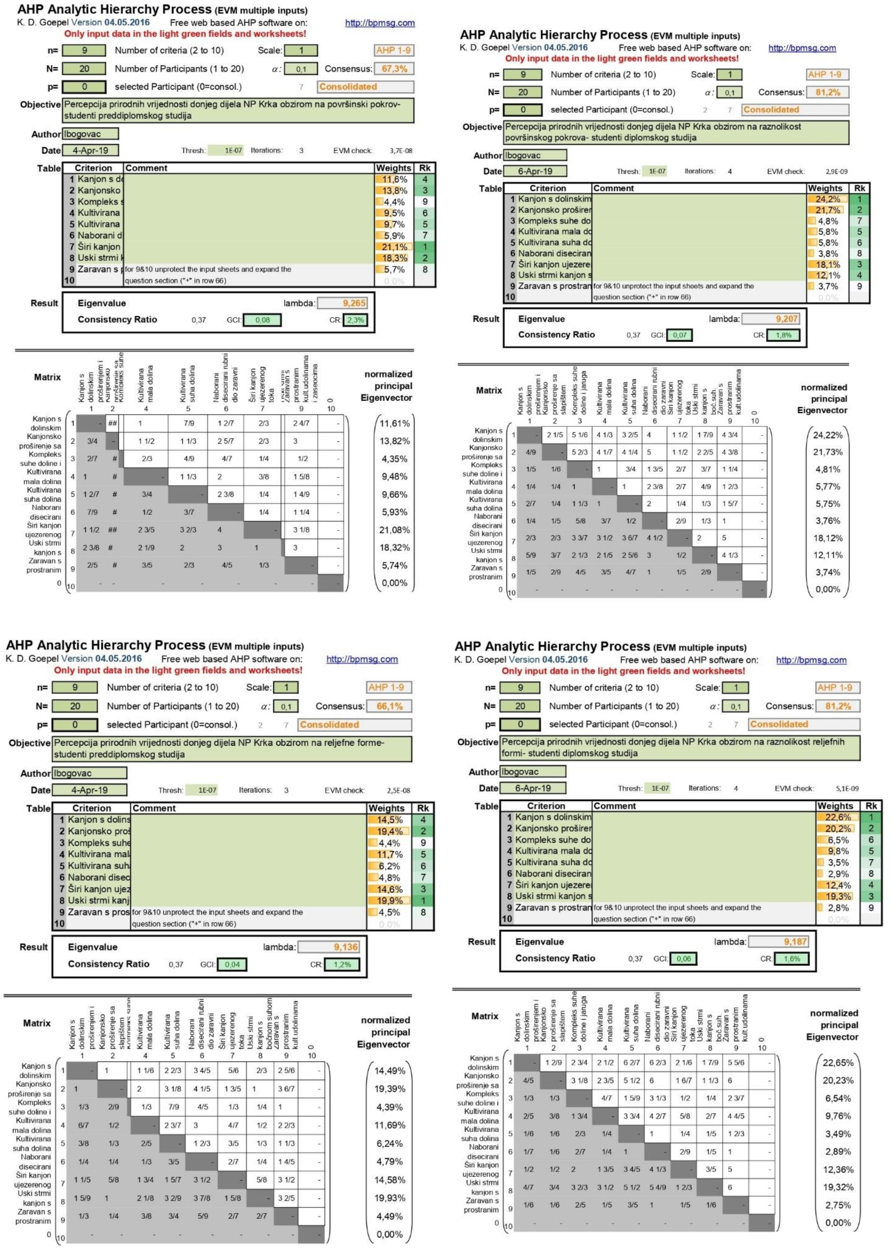
The results obtained by the survey were analysed using the AHP method [25], which reduces complexity by comparing pairs of individual criteria and thus facilitating the ranking of variant solutions (Appendix A). Saaty’s scale is a proportional scale that has five degrees of intensity and four intermediate levels, and each of them corresponds to a value judgment about how many times one criterion is more important than another [3]. Due to its simplicity, it is very often used in many analyses. In this paper, the previously mentioned Saaty scale was used to help assess the naturalness ratios of the depicted landscapes with respect to given criteria when their values are expressed quantitatively, qualitatively, and in different units of measurement. BPMSG AHP calculator <04.05.2016> was used to obtain the classification [37] (Table 3).
The last step in examining the perception of natural landscape qualities was the development of a value model in GIS software ProVal 2000 individually for each analysed landscape type, using the results obtained using the AHP method.

3.4. Application of Vulnerability Models of Landscape Quality

In its scope, the vulnerability model represents a very reduced and generalized structure. Various spatial characteristics are presented in the form of matrices by giving estimates to certain degrees of spatial occurrence, according to a predetermined scale. In this research a scale from 1 to 5 is taken, where 1 represents invulnerable, and 5 represents the most vulnerable. Landscape modelling, results comparison, and maps were made using GIS applications (QGIS 2.18., QGIS 3.10.5. and ProVal 2000).
Valuation techniques that are suitable for research in landscape architecture always begin with the determination of criteria (explicit rules that help to choose between variants). Determining the criteria of vulnerability of landscape quality is the starting point for the design of simulation models obtained by reviewing and categorizing spatial data. The criteria in this case serve to design models that will simulate the qualities of the landscape [1], and the same criteria were selected as when creating the survey questionnaire: (1) variety of land cover, (2) variety of relief forms, (3) degree of landscape fragmentation, and (4) type of water element.

4. Results

4.1. The Synthesis of the Results of the Questionnaire

Previous research has shown that there are differences in perception that can be related to the objective characteristics of the subject, in our case the respondents. Some studies, however, have found that there are certain indicators that are causing consensus in perception, given the objective characteristics of the landscape, among which the naturalness of the landscape stands out the most [49]. The natural landscape will thus always be highly positively valued regardless of the socio-cultural and other differences of the respondents.
Brunetta and Voghera [12] define two types of values, namely consolidated values (values recognized by the general public as an integral part of a community’s identity (e.g., Skradinski buk) and normative values (previously determined values of space, often include the above values). That typology is also recognized in the results of this research.
On the other hand, society, imbued with its historical, cultural, material, spiritual, or symbolic experience, influences not only the landscape and its changes, but also the change in the perception of the landscape and its future processes. Associations are related to the person who perceives values, their personal experience, preferences (orientations), and the social context of the value system [31].
By conducting a survey questionnaire (i.e., processing the results obtained by the research, several findings were made).

4.1.1. Variety of Land Cover

Undergraduate students (Table 4) perceive the most natural landscape type as the wide canyon of semi stagnant river course (21.1%), followed by the narrow steep canyon with a lateral dry valley (18.3%) and the canyon with tufa barriers (13.8%), while the least natural quality is attributed to the area with dry valleys and gullies (4.4%).
Graduate students (Table 4) perceive the landscape type canyon with a valley widening and lateral dry valleys (24.2%), then canyon with tufa barriers (21.7%) and wide canyon of semi stagnant river course as the most natural (18.1%), while the least natural qualities are attributed to the Karst plain with extensive cultivated valley and hamlets (3.7%).
Considering the diversity of the land cover, we see that the largest number of respondents among the most natural classifies the wide canyon of semi stagnant river course and the canyon with tufa barriers.

4.1.2. Variety of Relief Forms

Undergraduate students (Table 5) perceive the narrow steep canyon with a lateral dry valley (19.9%) as the most natural, followed by the canyon with tufa barriers (19.4%) and the wide canyon of semi stagnant river course (14.6%), while the least natural quality is attributed to the Area with dry valleys and gullies (4.4%).
Graduate students (Table 5) perceive the landscape type canyon with a valley widening and lateral dry valleys (22.6%) as the most natural, followed by canyon with tufa barriers (20.2%) and narrow steep canyon with a lateral dry valley (19.3%), while the least natural qualities are attributed to the Karst plain with extensive cultivated valley and hamlets (2.8%).
Considering the variety of relief forms, we see that the largest number of respondents among the most natural classifies the narrow steep canyon with a lateral dry valley and the canyon with tufa barriers.

4.1.3. Degree of Landscape Fragmentation

Undergraduate students (Table 6) perceive the landscape type canyon with tufa barriers as the most natural (17.0%), followed by the wide canyon of semi stagnant river course (13.4%) and the narrow steep canyon with a lateral dry valley (13.2%), while the least natural quality is attributed to the folded and dissected edge of karst plain (7.6%).
Graduate students (Table 6) perceive the landscape type ‘canyon with tufa barriers’ as the most natural (28.8%), followed by the canyon with a valley widening and lateral dry valleys (16.1%) and the narrow steep canyon with a lateral dry valley (14.4%), while the least natural qualities are attributed to the area with dry valleys and gullies (4.2%).
Considering the degree of landscape fragmentation, we see that the largest number of respondents among the most natural qualities classifies the canyon with tufa barriers and the narrow steep canyon with a lateral dry valley. Also, it is evident that graduate students according to the diversity of surface cover and relief forms and the degree of landscape fragmentation give the highest natural qualities to the canyon with tufa barriers.

4.1.4. Type of Water Element

Undergraduate students (Table 7) perceive the landscape of the wide canyon of semi stagnant river course (46.3%) as the most natural, followed by the canyon with tufa barriers (40.7%), while the canyon with a valley widening and lateral dry valleys are attributed the least natural qualities. (13.0%).
Graduate students (Table 7) perceive the canyon with tufa barriers as the most natural type (54.2%), followed by the wide canyon of semi stagnant river course (31.7%), while the least natural qualities are attributed to the canyon with a valley widening and lateral dry valleys. (14.1%).
Considering the type of water element, we see that the largest number of respondents consider the landscape type ‘canyon with tufa barriers’ to be the most natural.

4.2. Development of a Model of Vulnerability of Natural Landscape Qualities

The model of natural landscape qualities (Figure 6) is defined primarily through the distance from the zones of natural values of the Krka National Park. Furthermore, natural qualities are defined through their distance from existing pollutants (roads, settlements and energy infrastructure) since the distance from anthropogenic influence increases the naturalness of the landscape. A very important component of the natural landscape qualities are the relief forms, which significantly contribute to the natural structure of the area or its proximity. Therefore, the coluvial cones of this area on the steepest slopes, especially in the canyon, are determined as the highest quality of the relief structure of the natural landscape. Due to the naturalness of forest habitats and their role in the structure of the landscape, the distance from forests was an important criterion for the natural qualities of the landscape, whereby the quality decreases with distance [5].
The vulnerability of the natural environment is proportional to the increase in the distance of natural features from various anthropogenic forms. The appearance of anthropogenic structures reduces naturalness, self-sustainability, visual value, and other natural qualities. Distancing from the anthropogenic source, the quality of the environment and vulnerability increase.
The most vulnerable area is where natural elements are most differentiated, which means that it has the greatest diversity of biocenosis, phytocenosis, and ecosystems. These are, for example, areas along streams, tributaries, forest areas, bushes, wetlands, etc., or all areas where different types of phytocenosis alternate in a fairly small area, which necessarily leads to a rich variety of species of biosphere (flora and fauna). Due to opposite factors, the least vulnerable areas are close to settlements, industrial zones, and infrastructure [1].
Given the criteria for determining naturalness, the used data included:
  • Variety of land cover; data for land cover were used where firstly all land cover was directly evaluated (grades 0–5), and then natural land cover (e.g., forest vegetation, wetland vegetation, grasslands and meadows) was accented out, which was evaluated through buffer zones from the edge of the area (by distance natural qualities are diminishing).
  • Variety of relief forms; data for the land cover were again used (tufa barriers, a fundamental phenomenon of the Krka National Park, whose value is weighted due to its exceptionality; and rocks) and a map of the slope of the research area, where steeper parts were defined as more natural.
  • Degree of landscape fragmentation; here the naturalness of landscape types was defined through the distance from anthropogenic elements (e.g., roads, settlements, landfills, etc.) distance from selected elements increases natural qualities
  • Type of water element; stagnant and flowing waters and a lake were extracted from the data for the land cover.

4.3. Development of a Model of Perception of Natural Landscape Qualities

According to the results of the AHP analysis, each submodel criterion was weighted. The last step in examining the perception of natural landscape qualities was modelling in the GIS application ProVal2000, individually for each analysed landscape type using the results obtained by AHP analysis. The homogeneous spatial unit used to display the data in this raster program was a 10 × 10 m pixel.
Spatial data for each landscape type were inserted in the program modeler. Every obtained datum is weighted (i.e., by including the weight, the value is multiplied by the value of the weight, which increases their total value in the further process of merging and overlapping). In this case, the value of the used weight was equal to the sum of the percentage obtained by a particular landscape type using the AHP method (e.g., 11.6% is written as a decimal number—0.116) and added to 1, which mean that the weight for the specified landscape type is 1.116.
The obtained results of undergraduate and graduate students for the specified landscape type were combined, individually for each criterion, in order to get the value of each homogeneous spatial unit with respect to the values of all input data.
The final value of each landscape unit was obtained by calculating the arithmetic mean of the input values for these criteria. The output data for each landscape type were finally merged, resulting in a model of perception of natural landscape quality (Figure 7).

5. Discussion

The subject of this discussion are the results of the research which aim to point out the importance of examining landscape values and the perception of its values (i.e., public or stakeholder participation). Butula [50] points out that one of the very important tasks of spatial planning is to investigate how certain groups perceive space and its qualities.
The selected criteria for determining natural qualities were proved to be applicable to all landscape types, and it was possible to easily quantify and map them. This is accurate for research through an online survey questionnaire, but also for evaluation using landscape modelling. Atik et al. [6] in their research emphasize that the basis for landscape policies based on distinct local characters is the integration of aesthetic and perceived qualities in landscape evaluation.
By analysing the results of the survey, we came to findings about the perception of respondents. Both groups of respondents identified landscape types that include the Krka and Čikola river canyons (i.e., canyon with a valley widening and lateral dry valleys, narrow steep canyon with a lateral dry valley, canyon with tufa barriers) as landscapes with the highest natural qualities.
Deviations between the value assessments of undergraduate and graduate students were observed (Table 4, Table 5, Table 6 and Table 7). Despite the fact that both groups prefer landscape types in the Krka and Čikola river canyons, graduate students more often choose some of the canyon types from the offered pairs of landscape types in the questionnaire and evaluate them equally compared to other respondents from that group. This gives us insights that, due to previously acquired knowledge, graduate students recognize the natural qualities of the landscape with greater certainty even through photographs.
Experience has partially shown that the evaluation of such large landscape types using photographs usually cannot give completely realistic results. Although each landscape type has been shown in photographs to demonstrate a large set of elements that define landscape character, sometimes it cannot be enough for a person unfamiliar with the area to make a realistic assessment of the area’s value, as photographs cannot replace spatial experience. This is accurate regardless of whether the population or professionals are surveyed [1]. Therefore, this finding should be taken into account when comparing the model of vulnerability of natural qualities, developed by experts who have more information about space, and the model of perception of natural qualities based on social research, wherein it is important to include the person who perceives these changes and acts on the basis of that perception [31].
The share of values in the model of vulnerability of natural qualities (Table 8; Figure 8) shows that the group of the most vulnerable areas (5) includes 0.26% of the total coverage of the southern part of the Krka National Park and includes only tufa barriers on Skradinski buk. The group of very vulnerable areas (4) included 10.18% (steep parts of the sides of the Krka and Čikola river canyons and the Čikola river valley), while medium vulnerable areas cover more than half of the coverage (55.65%) and include a wider area of both canyons. Marginally vulnerable (2) and invulnerable areas (1) occupy 38.91%, which is slightly more than a third of the analysed area, which includes the areas of Ravni kotari and the North Dalmatian plateau.
Comparing the above results with those from the combined model of vulnerability and perception of natural qualities, it is evident that the vulnerability of natural qualities increased by overlapping. We argue that the reason is that the combined model includes a model of perception in which the evaluation was performed by landscape types, which greatly simplifies the analysed coverage area. Results show that 7.88% of the area is the most vulnerable (5), and that the largest part of the coverage area belongs to very vulnerable areas (4; 56.23%). These are the areas of the Krka and Čikola river canyons, where the most valuable parts are the areas of travertine barriers (Skradinski buk) and the steep parts of the sides of the Krka river canyon. Results show that in the area of Ravni kotari there is 11.25% of medium vulnerable areas (3), while a quarter of the area within the North Dalmatian plateau was evaluated as either marginally vulnerable (2; 20.16%) or invulnerable (1; 4.48%) (Table 9).

6. Conclusions

The purpose of this research was not only to identify approaches that can be applied in the planning and management of natural values through a review of previous research, but also to examine the practical application of acquired knowledge through survey research and landscape modelling.
The results of the research confirmed the preconceived hypothesis that the respondents will perceive landscape types in the area of the Krka and Čikola river canyons as more natural, given the diversity of land cover and relief forms. Considering that three of the four mentioned landscape types also have a water element in their scope, the second hypothesis was confirmed, according to which the respondents perceive more naturally the landscape types in which the water element is present.
By overlapping the model of vulnerability of natural landscape qualities and the combined model of vulnerability and perception of natural qualities, it was determined that there are not only overlaps between the models but also deviations. Deviations occur due to different levels of detail of the combined model of vulnerability and perception of natural qualities. In the model of perception, the homogeneous spatial unit being evaluated is the landscape unit, while in the vulnerability model, the homogeneous spatial unit is a pixel. At the same time, a larger amount of data was used in the vulnerability model, the overlap of which provided a more detailed insight into the value of the landscape. This confirms the last hypothesis of this paper that the implementation of perceived natural qualities of certain landscape types in the evaluation process affects the model of vulnerability of landscape quality. By comparing the results of both approaches, it can be concluded that the possible procedure of implementation of perceived landscape qualities into the evaluation process was determined (which was one of the general goals of this research). Furthermore, the classification of landscape types with regard to the perception of their natural qualities as the second general goal of this paper has been established. The comparison of the obtained models shows the same logic of classification; the highest natural qualities of the landscape were identified in the same areas within both models, regardless of the used approach.
This confirms the position of Cifrić and Trako [31] who state that sociological landscape research, which emphasizes the associative multidimensionality of subjective landscape evaluation, is crucial and can be further used to protect landscapes, biological and cultural diversity, and natural and cultural planning. This is especially evident in comparison of these results with established objective indicators of perception. This also applies to the evaluation of the natural qualities of the landscape, the perception of which is extremely important and does not always necessarily imply the ecological value of the space.
In future research, it is necessary to include more stakeholders with different agendas such as visitors, local community and professionals. A very important factor that should be taken into account is familiarity and knowledge of the research area. Challenges of the research on landscape character are constant changes of the landscape as a result of natural and human interaction in space. Thus, over time periodical research is recommended. Furthermore, this paper identified the AHP method as an appropriate approach in low diverse areas and smaller areas, such as the southern part of the Krka National Park. However, in highly diverse areas the number of possible pairs would be an overwhelming task for the respondents, so the results could be invalid.
Based on the research presented in this paper, and according to the definition of the ELC, which says that a landscape is an area perceived by people, it is concluded that human landscape perception cannot be left out of the landscape evaluation process if all values in space are to be included.

Author Contributions

Conceptualization, L.B. and D.T.R.; methodology, L.B., D.T.R.; software, L.B.; formal analysis, L.B.; investigation, L.B. and D.T.R.; resources, L.B. and D.T.R.; data curation, I.H. and M.K.; writing—original draft preparation, L.B. and D.T.R.; writing—review and editing, M.K., I.H. and P.P.; visualization, L.B.; supervision, P.P. All authors have read and agreed to the published version of the manuscript.

Funding

This research received no external funding.

Institutional Review Board Statement

Not applicable.

Informed Consent Statement

Not applicable.

Data Availability Statement

The data that support our research findings are available from the corresponding author on request.

Conflicts of Interest

The authors declare no conflict of interest.

Appendix A. Results of AHP Method

Sustainability 13 13485 g0a1aSustainability 13 13485 g0a1b

References

  1. Butula, S.; Andlar, G.; Hrdalo, I.; Hudoklin, J.; Kušan, T.; Kušan, V.; Marković, B.; Šteko, V. Inventory, Valuation and Planning of Dalmatian Coastal Landscapes: The Area of the Krka River Estuary (in Croatian). COAST Project: Conservation and Sustainable Use of Biodiversity in the Dalmatian Coast. OIKON LTD Zagreb, Department of Ornamental Plants, Landscape Architecture and Garden Art, University of Zagreb, Faculty of Agriculture, Urbanistički Institut Ljubljana. 2009, pp. 85–110. Available online: https://www.academia.edu/2508507/COAST_project_Inventarisation_Evaluation_and_Planning_of_Dalmatias_Coastal_Landscape_River_Krka_estuary (accessed on 10 March 2019).
  2. Park, C. A Dictionary of Environment and Conservation; Oxford University Press: New York, NY, USA, 2007; p. 299. [Google Scholar]
  3. Tomić Reljić, D. The Harmonisation of Conservation and Development Requirements in Planning of Sustainable Spatial Development. Ph.D. Thesis, University of Zagreb, Zagreb, Croatia, 14 July 2017; pp. 6–34. (In Croatian). [Google Scholar]
  4. Swanwick, C. Landscape Character Assessment: Guidance for England and Scotland. Department of Landscape, University of Sheffield, Land Use Consultants. 2002, p. 8. Available online: https://www.nature.scot/sites/default/files/2018-02/Publication%202002%20-%20Landscape%20Character%20Assessment%20guidance%20for%20England%20and%20Scotland.pdf (accessed on 1 October 2021).
  5. Andlar, G.; Šteko, V.; Tomić, D. LCA Study of Krka National Park; University of Zagreb, Faculty of Agriculture, Department of Ornamental Plants, Landscape Architecture and Garden Art: Zagreb, Croatia, 2015; pp. 7–10. (In Croatian) [Google Scholar]
  6. Atik, M.; Işıklı, R.C.; Ortaçeşme, V.; Yıldırım, E. Definition of landscape character areas and types in Antalya-Turkey Side region according to land use planning. Land Use Policy 2015, 44, 90–100. [Google Scholar] [CrossRef]
  7. Koç, A.; Yılmaz, S. Landscape character analysis and assessment at sub-pressure scale. Appl. Geogr. 2020, 125, 102359. [Google Scholar] [CrossRef]
  8. Brown, G.; Brabyn, L. An analysis of the relationships between multiple values and physical landscapes at a regional scale using public participation GIS and landscape character classification. Landsc. Urban Plan. 2012, 107, 317–331. [Google Scholar] [CrossRef]
  9. Golobič, M. Kartiranje normativnega znanja: Spoznajni zemljevidi in GIS. In Geografski informacijski sistemi v Sloveniji 2005–2006; Perko, D., Nared, J., Čeh, M., Hladnik, D., Krevs, M., Podobnikar, T., Šumrada, R., Eds.; ZRC: Ljubljana, Slovenia, 2006; pp. 159–168. Available online: https://giam.zrc-sazu.si/sl/publikacije/geografski-informacijski-sistemi-v-sloveniji-20052006 (accessed on 1 October 2021).
  10. Croatian Official Gazette, 12/02. Zakon o Potvrđivanju Konvencije o Europskim Krajobrazima; Croatian Parliament: Zagreb, Croatia, 2002; Available online: https://narodne-novine.nn.hr/clanci/medunarodni/2002_10_12_144.html (accessed on 10 September 2021).
  11. McHarg, I. Design with Nature; The Natural History Press: New York, NY, USA, 1969; pp. 67–117. [Google Scholar]
  12. Brunetta, G.; Voghera, A. Evaluating Landscape for Shared Values: Tools, Principles and Methods. Landsc. Res. 2008, 33, 71–87. [Google Scholar] [CrossRef]
  13. Wardenbach, T. Botschaft vom Drachenfels—Geotopschutz, die neue Aufgabe im Natur und Landschaftsschutz. Jahrb. Okol. 2000, 2001, 246–271. [Google Scholar]
  14. Olwig, K.R. The practice of landscape ‘Conventions’ and the just landscape: The case of the European landscape convention. Landsc. Res. 2007, 32, 579–594. [Google Scholar] [CrossRef]
  15. Ipsen, D. The sociology of landscape. In Exploring the Boundaries of Landscape Architecture; Bell, S., Sarlöv Herlin, I., Stiles, R., Eds.; Routledge: London, UK; New York, NY, USA, 2012; pp. 60–82. [Google Scholar]
  16. Daugstad, K.; Svarstad, H.; Vistad, O.I. A case of conflicts in conservation: Two trenches or a three-dimensional complexity? Landsc. Res. 2006, 31, 1–19. [Google Scholar] [CrossRef]
  17. Jones, M. The European landscape convention and the question of public participation. Landsc. Res. 2007, 32, 613–633. [Google Scholar] [CrossRef]
  18. Ode, Å.; Tveit, M.S.; Fry, G. Capturing Landscape Visual Character Using Indicators: Touching Base with Landscape Aesthetic Theory. Landsc. Res. 2008, 33, 89–117. [Google Scholar] [CrossRef]
  19. Croatian Official Gazette, NN 1/2007. Zakon o Potvrđivanju Konvencije o Pristupu Informacijama, Sudjelovanju Javnos-ti u Odlučivanju i Pristupu Pravosuđu u Pitanjima Okoliša; Croatian Parliament: Zagreb, Croatia, 2007; Available online: https://narodne-novine.nn.hr/clanci/medunarodni/2007_01_1_2.html (accessed on 12 September 2021).
  20. Metzger, M.J.; Rounsevell, M.D.A.; Van den Heiligenberg, H.; Perez-Soba, M.; Soto Hardiman, P. How Personal Judgment Influences Scenario Development: An Example for Future Rural Development in Europe. Ecol. Soc. 2010, 15. Available online: http://www.ecologyandsociety.org/vol15/iss2/art5/ (accessed on 10 April 2019). [CrossRef]
  21. Simonič, T. Preference and perceived naturalness in visual perception of naturalistic landscapes. Kmet 2003, 81, 369–387. Available online: http://aas.bf.uni-lj.si/september2003/16simonic.pdf (accessed on 15 April 2019).
  22. Tveit, M.; Ode, Å.; Fry, G. Key concepts in a framework for analysing visual landscape character. Landsc. Res. 2006, 31, 229–255. [Google Scholar] [CrossRef]
  23. Bell, S. Elements of Visual Design in the Landscape; E & F N Spon: London, UK, 1993; p. 5. [Google Scholar]
  24. Feizizadeh, B.; Blaschke, T. Land suitability analysis for Tabriz District, Iran: A multi-criteria assessment approach using GIS. J. Environ. Plan. Manag. 2013, 56, 1–23. [Google Scholar] [CrossRef]
  25. Saaty, T.L. A scaling method for priorities in hierarchical structures. J. Math. Psychol. 1977, 15, 234–281. [Google Scholar] [CrossRef]
  26. Marušič, J. Oblike vrednotenja v krajinskem načrtovanju. Urbani Izziv 1991, 18, 7–45. [Google Scholar]
  27. Butula, S. River Landscape Value Systems as a Basis for Planning. Ph.D. Thesis, University of Zagreb, Zagreb, Croatia, 2004. [Google Scholar]
  28. Falconer, L.; Hunter, D.-C.; Telfer, T.C.; Ross, L.G. Visual, seascape and landscape analysis to support coastal aquaculture site selection. Land Use Policy 2013, 34, 1–10. [Google Scholar] [CrossRef]
  29. Deming, M.E.; Swaffield, S. Landscape Architecture Research; Inquiry, Strategy, Design; John Wiley and Sons: Hoboken, NJ, USA, 2011; pp. 87–113. [Google Scholar]
  30. Marušič, J. Krajinsko Planiranje. Vtozd za Agronomijo; Študij Urejenja Krajine: Ljubljana, Slovenia, 1987. [Google Scholar]
  31. Cifrić, I.; Trako, T. Usporedba percepcije prirodnog i kulturnog krajobraza u Hrvatskoj. Primjena metode semantičkog diferencijala. Soc. Ekol. 2008, 17, 379–403. [Google Scholar]
  32. Lothian, A. Landscape and the philosophy of aesthetics: Is landscape quality inherent in the landscape or in the eye of the beholder? Landsc. Urban Plan. 1999, 44, 177–198. [Google Scholar] [CrossRef]
  33. Saraiva, M.G. Landscape planning and management between research perspectives and policy approaches in Portugal. Passways for integration? In Proceedings of the 23rd Session of the PECSRL—The Permanent European Conference for the Study of the Rural Landscape—Landscape, Identities and Development, Lisabon/Obidos, Portugal, 1–5 September 2008. [Google Scholar]
  34. Čaldarović, O. Konceptualizacija prirode kao vrijednosti javnog dobra i aspekti njezine valorizacije. Rev. ZaSociol. 2006, 37, 47–62. [Google Scholar]
  35. Public Institution “National Park Krka”. The Management Plan of Krka National Park; Public Institution “National Park Krka”: Šibenik, Croatia, 2011; p. 11. Available online: https://www.np-krka.hr/stranice/management-plan-for-krka-national-park/6/en.html (accessed on 12 March 2019).
  36. Swanwick, C.; Fairclough, G. Landscape character: Experience from Britain. In Routledge Handbook of Landscape Character Assessment; Fairclough, G., Sarlov Heflin, I., Swanwick, C., Eds.; Routledge, Taylor & Francis Group: London, UK; New York, NY, USA, 2018. [Google Scholar]
  37. Goepel, K.D. Implementing the Analytic Hierarchy Process as a Standard Method for Multi-Criteria Decision Making in Corporate Enterprises—A New AHP Excel Template with Multiple Inputs. In Proceedings of the International Symposium on the Analytic Hierarchy Process; Creative Decisions Foundation, Kuala Lumpur, Malaysia, 3–6 December 2013; pp. 1–10. [Google Scholar]
  38. Eastman, J.R. IDRISI Kilimanjaro Guide to GIS and Image Processing; Manual Version 14.00; Clark Labs: Worchester, MA, USA, 2003; Available online: https://www.mtholyoke.edu/courses/tmillett/course/geog307/files/Kilimanjaro%20Manual.pdf (accessed on 1 October 2021).
  39. Tomić Reljić, D.; Koščak Miočić-Stošić, V.; Butula, S.; Andlar, G. An Overview of GIS Applications in Landscape Planning. Kartogr. I Geoinformacije 2017, 16, 26–43. [Google Scholar]
  40. Solecka, I. The use of landscape value assessment in spatial planning and sustainable land management—A review. Landsc. Res. 2018, 44, 966–981. [Google Scholar] [CrossRef]
  41. Havas, J.; Saito, O.; Hanaki, K.; Tanaka, T. Perceived landscape values in the Ogasawara Islands. Ecosyst. Serv. 2016, 18, 130–140. [Google Scholar] [CrossRef]
  42. Ode, Å.; Fry, G.; Tveit, M.S.; Messager, P.; Miller, D. Indicators of perceived naturalness as drivers of landscape preference. J. Environ. Manag. 2009, 90, 375–383. [Google Scholar] [CrossRef]
  43. Arriaza, M.; Cañas-Ortega, J.; Cañas-Madueño, J.; Ruiz-Aviles, P. Assessing the visual quality of rural landscapes. Landsc. Urban Plan. 2004, 69, 115–125. [Google Scholar] [CrossRef]
  44. Brush, R.O. Landform and scenic preference: A research note. Landsc. Plan. 1981, 8, 301–306. [Google Scholar] [CrossRef]
  45. Nasar, J.L.; Li, M. Landscape mirror: The attractiveness of reflecting water. Landsc. Urban Plan. 2004, 66, 233–238. [Google Scholar] [CrossRef]
  46. Wherrett, J.R. Creating Landscape Preference Models Using Internet Survey Techniques. Landsc. Res. 2000, 25, 79–96. [Google Scholar] [CrossRef]
  47. Kaplan, R.; Kaplan, S. The Experience of Nature: A Psychological Perspective, 1st ed.; Cambridge University Press: Cambridge, NY, USA, 1989. [Google Scholar]
  48. Appleton, K.; Lovett, A. GIS-based visualisation of rural landscapes: Defining ‘sufficient’ realism for environmental decision-making. Landsc. Urban Plan. 2003, 65, 117–131. [Google Scholar] [CrossRef]
  49. Rogge, E.; Nevens, F.; Gulinck, H. Perception of rural landscapes in Flanders: Looking beyond aesthetics. Landsc. Urban Plan. 2007, 82, 159–174. [Google Scholar] [CrossRef]
  50. Butula, S. Planning for sustainable development: The significance of different social interests in landscape. Društvena Istraživanja 2003, 12, 427–441. [Google Scholar]
Figure 1. Overview of the selected area in relation to the border of the Krka National Park.
Sustainability 13 13485 g001
Figure 2. Preclassification of landscape character areas and types: (a) relief; (b) geology; (c) soil types; (d) vegetation; (e) land use; (f) settlements (data source: [5]).
Sustainability 13 13485 g002
Figure 3. Areas of the wider regional level of the southern part of the Krka National Park.
Sustainability 13 13485 g003
Figure 4. Landscape types of the Krka National Park.
Sustainability 13 13485 g004
Figure 5. Photographs that represent identified landscape types.
Sustainability 13 13485 g005
Figure 6. Model of vulnerability of natural landscape qualities.
Sustainability 13 13485 g006
Figure 7. Model of perception of natural landscape qualities.
Sustainability 13 13485 g007
Figure 8. Cartographic presentation of the combined model of vulnerability and perception of natural landscape qualities.
Sustainability 13 13485 g008
Table 2. Criteria for natural qualities of the landscape of the southern part of the Krka National Park.
CriteriaDescription
Variety of surface coverNumber and variation in surface cover in the landscape units (e.g., forest, agricultural crops, grassland, shrubby vegetation, water, settlements, etc.).
Variety of relief formsVariation of relief forms and the diversity of relief elements in the landscape units (e.g., canyons, bays, ravines, travertine barriers, plateaus, etc.).
Degree of landscape fragmentationDegree in which natural land cover is separated and broken in the smaller, disconnected or insulated sections.
Type of water elementExistence of abundance of water elements in the presented landscape units (e.g., lake, stagnant water, occasional and permanent streams, etc.).
Table 3. Saaty’s 1–9 scale of pairwise comparison (Saaty, 1977).
Intensity of ImportanceDefinitionDescription
1Equally importantTwo criteria or alternatives equally contribute to the goal
3Moderately importantBased on experience and assessment, a moderate advantage is given to one criterion or alternative over another.
5Very importantBased on experience and evaluation, one criterion or alternative is strongly favored over another.
7Very strict, proven importanceOne alternative criterion is strongly favored over another; its dominance is proven in practice
9Extreme importanceEvidence on which one criterion or alternative is favored over another is confirmed with the greatest persuasiveness.
2, 4, 6, 8Intermediate values
Table 4. The relationship of the perceived value of natural landscape types according to the variety of land cover between undergraduate and graduate students.
Landscape TypesUndergraduate Students Graduate Students
1Canyon with a valley widening and lateral dry valleys11.60%24.20%
2Canyon with tufa barriers 13.80%21.70%
6Area with dry valleys and gullies 4.40%4.80%
7Cultivated small depression 9.50%5.80%
5Cultivated dry valley9.70%5.80%
8Folded and dissected edge of karst plain 5.90%3.80%
3Wide canyon of semi stagnant river course 21.10%18.10%
4Narrow steep canyon with a lateral dry valley18.30%12.10%
9Karst plain with extensive cultivated valley and hamlets5.70%3.70%
100.00%100.00%
Table 5. The relationship of the perceived value of natural landscape types according to the variety of relief forms between undergraduate and graduate students.
Landscape TypesUndergraduate Students Graduate Students
1Canyon with a valley widening and lateral dry valleys14.50%22.60%
2Canyon with tufa barriers 19.40%20.20%
6Area with dry valleys and gullies 4.40%6.50%
7Cultivated small depression 11.70%9.80%
5Cultivated dry valley6.20%3.50%
8Folded and dissected edge of karst plain 4.80%2.90%
3Wide canyon of semi stagnant river course 14.60%12.40%
4Narrow steep canyon with a lateral dry valley19.90%19.30%
9Karst plain with extensive cultivated valley and hamlets4.50%2.80%
100.00%100.00%
Table 6. The relationship of the perceived value of natural landscape types according to the degree of landscape fragmentation between undergraduate and graduate students.
Landscape TypesUndergraduate Students Graduate Students
1Canyon with a valley widening and lateral dry valleys11.70%16.10%
2Canyon with tufa barriers 17.00%28.80%
6Area with dry valleys and gullies 7.90%4.20%
7Cultivated small depression 12.90%6.90%
5Cultivated dry valley8.60%6.80%
8Folded and dissected edge of karst plain 7.60%4.80%
3Wide canyon of semi stagnant river course 13.40%13.40%
4Narrow steep canyon with a lateral dry valley13.20%14.40%
9Karst plain with extensive cultivated valley and hamlets7.70%4.60%
100.00%100.00%
Table 7. The relationship of the perceived value of natural landscape types according to the type of water element between undergraduate and graduate students.
Landscape TypesUndergraduate Students Graduate Students
1Canyon with a valley widening and lateral dry valleys13.00%14.10%
2Canyon with tufa barriers 40.70%54.20%
3Wide canyon of semi stagnant river course 46.30%31.70%
100.00%100.00%
Table 8. Proportions of values (1–5) in the model of vulnerability of natural landscape qualities.
EvaluationNumber of PixelsArea (hectare)Portion in Coverage (%)Description
11828500182.855.01%invulnerable
2105509001055.0928.90%marginally vulnerable
3203188002031.8855.65%medium vulnerable
43718600371.8610.18%very vulnerable
5949009.490.26%most vulnerable
In total365117003651.17100%
Table 9. Proportions of values (1–5) in the combined model of vulnerability and perception of natural landscape qualities.
EvaluationNumber of PixelsArea (hectare)Portion in Coverage (%)Description
11635800163.584.48%invulnerable
27360900736.0920.16%marginally vulnerable
34106000410.611.25%medium vulnerable
4205301002053.0156.23%very vulnerable
52878900287.897.88%most vulnerable
In total365117003651.17100%
Publisher’s Note: MDPI stays neutral with regard to jurisdictional claims in published maps and institutional affiliations.

