Article

Complex Systems Thinking Approach to Urban Greenery to Provide Community-Tailored Solutions and Enhance the Provision of Cultural Ecosystem Services

Department of Agricultural, Food, and Environmental Sciences, Perugia University, 06121 Perugia, Italy
*
Author to whom correspondence should be addressed.
Sustainability 2021, 13(21), 11787; https://doi.org/10.3390/su132111787
Submission received: 17 September 2021 / Revised: 20 October 2021 / Accepted: 22 October 2021 / Published: 25 October 2021
(This article belongs to the Special Issue Landscape Analysis, Planning and Regional Development)

Abstract

:
This paper presents a GIS-based method for supporting local administrations in the design of urban green areas while taking into account the complexity of the whole system. The proposed method merges the criteria of availability, accessibility, attractiveness, usability, and suitability in a multi-level approach (city, neighborhood green area) to assist in the selection of which services within green areas to enhance from those requested by citizens. The case study is an urban park in a medium-sized Italian city (Perugia). The results demonstrate that the available urban green spaces amount to 34.7 m2 per person, but only 24% of citizens have adequate access to a green area providing at least an adequate level of service, and 18% of them are without access to any appropriately equipped green area. Furthermore, citizens have limited knowledge of their city’s urban green system as a whole. Indeed, 41% of the requested services were already available in other accessible green areas with attractive and readily available dedicated equipment. These areas were suggested as alternative solutions. To achieve a complex systems approach, our results suggest observing similar systems with various and adaptable scales and studying them as open networks composed of heterogeneous internal and external variables.

1. Introduction

The COVID-19 pandemic has had and will continue to have a strong impact on the world. The European cultural sector—crucial to the European economy and its citizens’ well-being—is paying a heavy price. This health crisis has affected museums, theaters, art galleries, life events, festivals, and trade fairs [1], necessitating the rapid adaptation of these sectors to guarantee their continued trade and survival. For this reason, urban planners and designers have demonstrated a newfound focus on spaces that naturally encourage physical distancing over more confined spaces, thereby maintaining greater control over the spread of pathogens. One potential lever of this transformation is the enhancement of urban open spaces. From a health point of view, open spaces allow for greater control of the spread of pathogens and for more natural physical distancing [2,3]. Among these urban areas, those belonging to the Urban Green System (UGS) already offer various Cultural Ecosystem Services (CES) [4], which have seen an increase in use during the COVID-19 pandemic [5,6,7]. In this context, there is a lack of holistic and collaborative approaches toward the realization of creative cultural services dedicated to the various needs of citizens, which will remain attractive even after the present pandemic [8]. Therefore, this is a favorable moment to initiate discussions and reflections to maintain the promotion and effectiveness of the UGS’ renewal and design. Particularly in dense cities where available land is scarce, planners must choose carefully the location for facilities that are able to provide the CES requested by citizens and, thus, realize a human-centered urban green network [9,10].
This paper proposes a method to manage the complexity of providing CES to local communities and, thus, contributes to the overall enhancement of the UGS. Before presenting the developed method, the next three subsections will sketch the main characteristics of the UGS’ complexity, thereby providing a literature-based framework of the criteria used to balance citizen’s demands of CES with the supply of urban greenery and introduce the case study.

1.1. Urban Greenery as a Complex System

A complex system is an open system in a state of dynamic equilibrium. It can also be described as a network connecting the various elements that constitute the system itself. The UGS is one such complex system. In this regard, its first characteristic is that it can be described as a network of green elements (areas, linear infrastructures, points) with variable rules governing the connections linked to their main functions in the urban context. Furthermore, it is an open system that exhibits dynamic relationships with all of the other components of the city. Many planners and scholars have studied these relationships, generally by focusing on a particular variable. For instance, Lahoti et al. [11] studied the UGS’s relationship to the distance from houses, Artman et al. [12] from care facilities, Biernacka et al. [10] from roads, Chen and Chang [13] from public transport stops, and Zhu et al. [5] from points of interest in a city. Other studies examined the relationship between the UGS and other urban land covers [14], landscape patterns [15], urban zoning [16], and socio-demographic variables [17]. Scholars have also studied links between the UGS and other city infrastructures [18], including grey infrastructures [19] and other urban open spaces [20], such as urban squares [21]. These evaluations too often consider the UGS to be a homogeneous system. In reality, even without external intervention, the UGS is composed of many living elements (trees, shrubs, herbs, small animals, and users), which change throughout their life; as a consequence, the system also continuously changes, and does so at different speeds depending on its constituent variables [22]. Furthermore, the nature of the internal and external linkages is nonlinear [23] and some of them are, therefore, unpredictable and, to a certain extent, unknown [21]. Menconi et al. [8] demonstrated that every action in a single green area changes the equilibrium of the system and can, thus, result in active synergies or conflicts with other elements of the UGS or with external variables.
For this reason, local administrators and urban planners require methods that are able to take into account all of the complexities of the UGS in their planning and design.

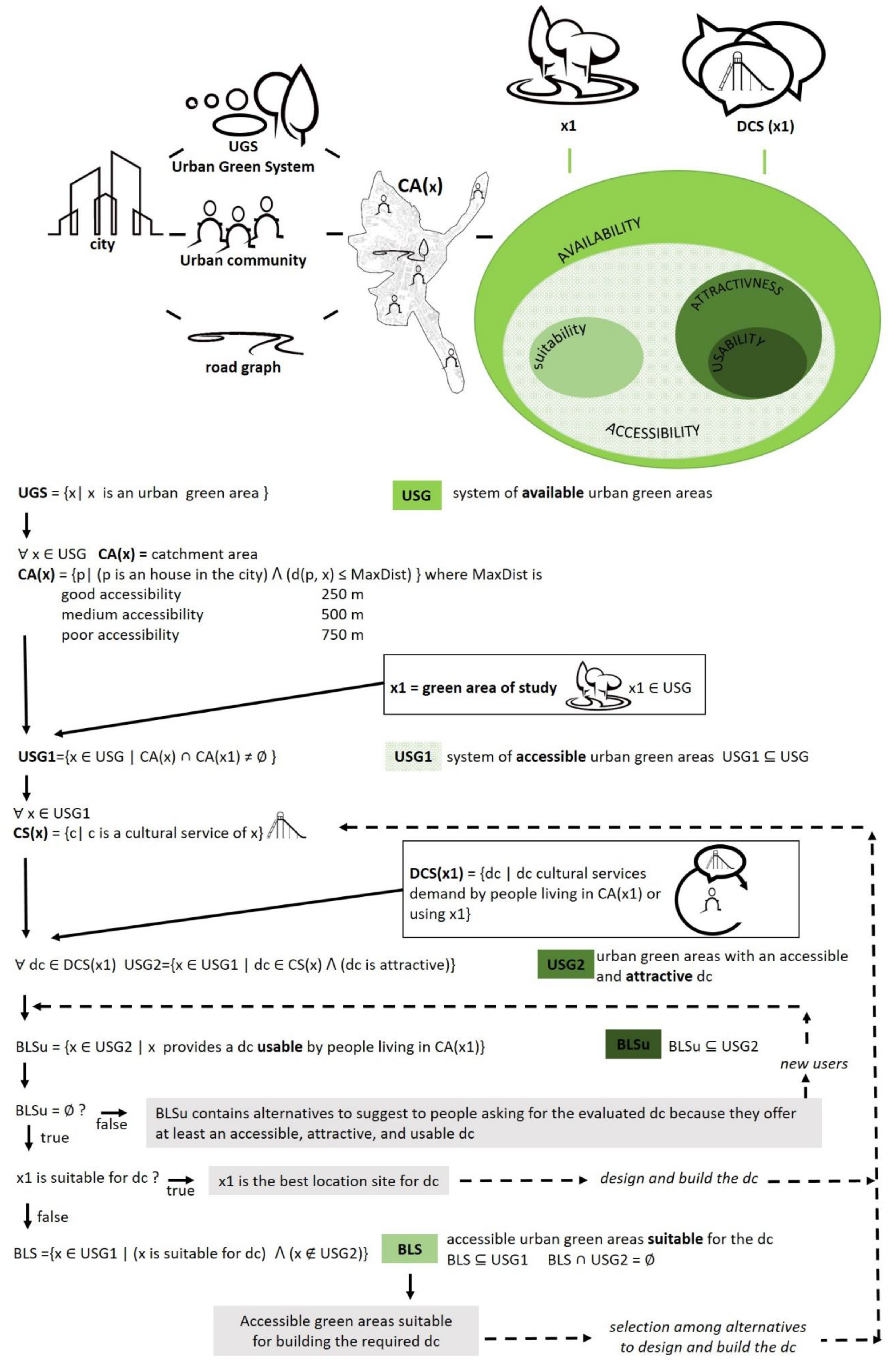
1.2. Criteria for Balancing the Supply of Urban Green Areas with Citizens’ Demands of CES

Urban green areas provide numerous benefits to people. The MEA group [24] has referred to CES as those services necessary for the pursuit of recreation, aesthetic enjoyment, improvement in physical and mental health, spiritual enrichment, social cohesion, cognitive development, and sense of place. Therefore, these services cover various activities including walking, jogging, running, picnicking, art performance, and aesthetic experiences in green areas [5]. One of the main limitations to their provision is the scarcity of dedicated equipment [5,9]. This paper focuses on the optimization of park furniture and leisure equipment planning to provide the CES requested by citizens. For this reason, in this paper, we consider a green area as able to provide CES when it provides park furniture and leisure equipment that promote the above activities.
To evaluate their supply, a common criterium is the “availability”, which speaks to the demand for green equipped areas in proximity to where people live [9,25]. Generally, scholars use the available municipal urban green censuses and local zoning plans as a source of information [10,26]; rarely do they involve the local community in the localization of green areas [12].
The existence of an urban green area does not guarantee access. Biernacka and Kronenberg [9] defined “accessibility” as the criterium for evaluating whether a green area is physically and psychologically accessible, in line with target 7 of the Sustainable Development Goal 11 [27]: “by 2030, provide universal access to safe, inclusive and accessible, green and public spaces”. In a review, Hegetschweiler [28] observed that many scholars evaluate physical accessibility purely in terms of entrances and reachability, using, for instance, an analysis of the fences or entrance parameters (i.e., entrance fees, opening hours) [9,10]. Akpinar [29] reported that a person’s capability to reach a place depends on the route distance and the presence or absence of obstacles to users along this route. Grunewald et al. [30] listed the main obstacles as road slopes, fast roads, multi-lane crossings, uneven sidewalks, unmaintained stairs, and various other architectural barriers. In this regard, some authors have created algorithms that can be used to evaluate urban design from the pedestrian point of view. For example, Koltsova et al. [31] evaluated the accessibility of green areas in regard to their degree of obstruction by nearby buildings. Meerow and Newell [32] used the concept of pedestrian accessibility to UGS as an indicator of social justice by determining the percentage of the population who can walk to a park within 10 min. A shared aim of these approaches is to guarantee distributional justice [25]. Ragab [33] analyzed accessibility using the concept of “buffers”. He identified compliance areas—a frame of sorts to the perimeter of green areas—and based on such areas determined the population contained within. In some cases, scholars evaluated accessibility with regard to particular groups within the population. For instance, Artman et al. [12] evaluated the potential and actual access to UGS of elderly citizens living in care facilities in Salzburg by considering real distances to green spaces and emerging barriers. Their results highlighted that 69% of the green areas visited were further away than closer alternatives that were overlooked, outlining a lack of research regarding green area qualities and their influence on citizens’ choices of where to go. This choice is also influenced by the sense of security [25] associated with spaces and linked to inappropriate behavior, discouraging uses, and dangerous surroundings [10]. Nonetheless, the evaluation of the quality of a green area involves many objective and subjective parameters and, thus, requires in-depth analysis.
Indices of quality vary with the disciplinary focus. For instance, some scholars considered the degree of biodiversity, landscape metric, number of users, and type and quality of recreational equipment [34,35,36]. Generally, a common criterium that evaluates the quality of an urban green area is its “attractiveness”, which is linked to the evaluation of whether the area meets the expectations of its users [10,25]. Biernacka and Kronenberg [9] defined a green area as attractive when one willingly wants to use it and spend his or her time there, and when this area corresponds with one’s individual needs, expectations, and preferences. This criterium is often measured with composite indicators of the green area quality [10], evaluating factors ranging from its equipment and appearance to factors that can negatively affect the perception of a given area and its surroundings [34,37]. The evaluation of a space’s attractiveness is crucial to its assessment by direct users [38].
The existence of accessible and attractive green areas does not always guarantee that these areas are usable—particularly during periods of health crisis, such as the COVID-19 pandemic, which ask for physical distancing. The emergence of freely available social media data from different locations, such as popular times based on geo-tagged data, provides new approaches to the analysis of visits to green spaces, which can easily be applied to the criterium of “usability” [5]. For instance, Richards et al. [39] used online photo sharing from social media; Zhang and Zhou [40] used geo-tagged check-in data to identify and map visits to different types of parks in central Beijing; Heikinheimo et al. [41] used temporally dynamic geographic information generated by different mobile devices and social media platforms to monitor users’ real-time presence in a green area.
This brief framework demonstrates that while scholars have developed many indices to analyze the supply–demand balance of urban green areas and CES, they rarely consider the differences between green areas and their variable value to the UGS. For instance, Menconi et al. [8] observed how many planners design green areas using standardized solutions to meet citizens’ requests without considering the consequences on the supply of similar services provided by other urban green areas. Elliot et al. [42] demonstrated a lack of holistic urban planning able to evaluate the differences between urban green areas in their provision of social and ecological benefits. Hegetschweiler et al. [28], in a review of the demand and supply factors involved in identifying CES provided by European urban green infrastructures, indicated that supply–demand relationships are complex, context-dependent, and far from thoroughly researched, confirming a lack of systematic approaches to their design and management.
For this reason, our method, described in the following section, merges the above indices into a multi-scale process capable of managing the diversity of citizen’s requests for services in urban green areas and was chosen as a case study in an overall plan to valorize the UGS.

1.3. Case Study

In this paper, we studied Perugia: a medium-sized city in central Italy. According to the National Statistical Institute [43], the Municipality of Perugia had a population of 165,956 inhabitants as of 1 December 2020. A total of 67% of them lived in the urban center, which is about 42 km2. As is the case in other historic cities [44], the UGS strategy faces challenges in Perugia owing to its extremely high-density living and the high value of land. This urban fabric requires particular policies that address the limited number of existing greenspaces, a reduced availability of open spaces to be utilized as new green spaces, and the pressures of the real estate market calling for new land to develop.
The proposed method was applied to renew the only historical park in the city center: “Giardini del Frontone”. Despite its small size of one hectare, it is a landmark of this medieval town due to being the oldest park and is located in the only flat neighborhood of an otherwise hilly historic center. The vegetation and equipment of the park required requalification as they were in critical condition. For these reasons, the study area was the object of a participatory process. We developed our method as a nested-level model to support decisions between the various CES demanded by citizens. Indeed, in many cases, planners have observed that participants request cultural services for the study area that could generate conflicts with other nearby spaces. For instance, people asked for a playground similar to an existing and under-used one in a nearby location, or they asked for equipment dedicated to loud events when many users generally visited this particular park to enjoy its quiet atmosphere. Planners need a transparent tool with which to discuss their evaluations with citizens and assist in the decision-making process. The following section describes the method developed to resolve this “black box”.

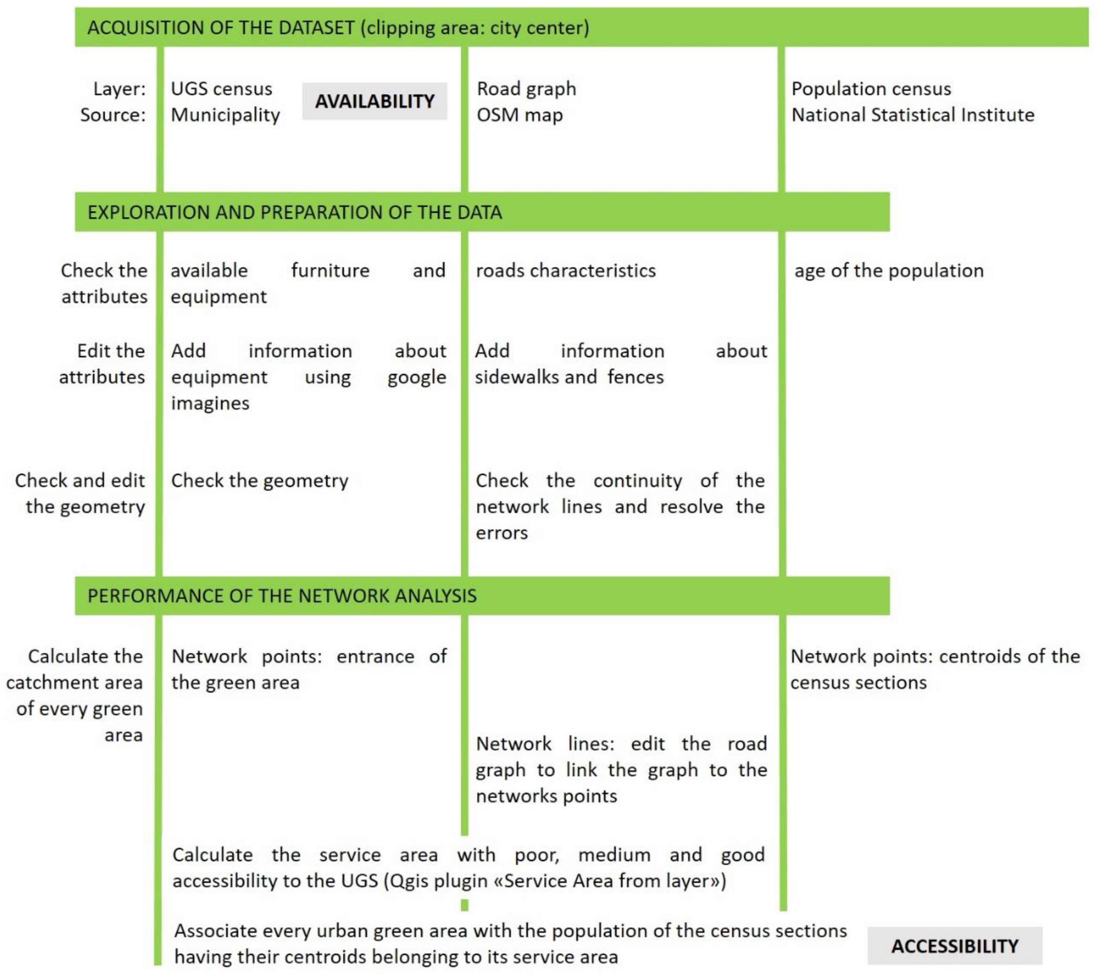
2. Materials and Methods

We developed a GIS-based method dedicated to determining the supply–demand balance of CES in an urban green area (the case study, hence referred to as x1) by evaluating its supply by the UGS. The method uses nested evaluation criteria, which is useful in narrowing down the survey surface at every step and detailing its analysis. Therefore, every criterion defines a spatial subselection of the previous criterion. Figure 1 presents a chart of this method.
The criteria are:
-
Availability. Is there an existing urban green area within the system that provides the requested cultural services? What distance is it from x1?
-
Accessibility. Are the available CES reachable by pedestrians using safe roads with no barriers (including architectural barriers, high-traffic roads, difficult crossings, fences, crossing of private property, opening hours, entrance fees)?
-
Attractiveness. Are the available CES attractive? Is the quality and appearance of their equipment and surroundings satisfactory?
-
Usability. Can the accessible cultural services increase their catchment area without compromising their usability? Are they currently under-used?
For every requested cultural ecosystem service, the above questions prove helpful to evaluate whether there is an existing green area that provides the requested service in an accessible, attractive, and usable manner. If not, we consider this further criterion:
-
Suitability. Is the x1 area suitable for its provision? Is there adequate space to realize the necessary equipment to provide the service? Are there any current uses of the green area or neighboring areas that could be in conflict with the new service?

Steps of the Method

The method starts with UGS analysis at the city level and ends with the suggestion of site-specific solutions for a green area. We performed the GIS analysis using QGIS software, version 3.4.12 (Madeira.) Figure 1 presents the steps of the method at the city level, and Figure 2 at the neighborhood and the green area levels.
First, we acquired a GIS dataset regarding the census of the UGS, the census of the population, and the road graph. For the UGS census, we used the institutional website of the Municipality of Perugia [45], which reports green areas’ surfaces, barriers, presence of parking, types of entrances, and types of paths. This census does not report the furniture and equipment that is generally used to evaluate CES provisioning [5,9,41]. Therefore, we zoomed into every park using Google Images to evaluate and group green areas by the availability of equipment. We defined these spaces as: (i) poor (areas providing only tables and benches); (ii) sufficient (areas providing equipment dedicated to a specific activity, such as a playgrounds, football fields, dog parks, community gardens, bowls playing areas, etc.); (iii) good (areas providing equipment dedicated to two activities); (iv) very good (areas providing equipment dedicated to more than two activities); and (v) optimal (large urban parks with equipped areas dedicated to at least five activities).
Next, we acquired the population census data from the National Statistical Institute [46] and the road graph using OpenStreetMap data. We developed a network analysis using the whole dataset for the evaluation of accessibility by defining as costs the walking distance along safe roads without barriers between green areas and citizens. We followed a precautionary principle to define costs using the walking speed of elderly people (3 km/h) [47]. To calculate walking distance starting points, we assumed that inhabitants were located in the centers of their census sections and used the entrances of the green areas as arrival points. We aimed to guarantee that citizens had access to a green area providing the requested service at small enough distances that they could use them daily. To achieve this aim, we calculated the catchment areas of every green space and assigned three levels of accessibility following the values used by Artmann et al. [12]: good (250 m, walking there takes 5 min); medium (500 m, walking there takes 10 min); and poor (750 m, walking there takes 15 min).
The above steps are all useful in evaluating the availability and accessibility of green areas at the city level. When the local administration plans a new green area or the renewal of an existing one, the method suggests utilizing successive zooms at the neighborhood and the green area levels to optimize CES provisioning (Figure 2).
Calling the study green area x1, we defined UGS1 as the first subset of the UGS collecting the green areas accessible by people living in the catchment area (CA) of x1 (Equation (1)):
USG1 = {x ∈ USG|CA(x) ∩ CA(x1) ≠ ∅}
For every green area x belonging to the UGS1 set, we extended the analysis at the neighborhood level to evaluate the available equipment and its attractiveness. Firstly, this step deepens the analysis of the criterium of availability because, at the city level, we evaluated the existence of the green areas and estimated only the consistency of their equipment. At the neighborhood level, we performed field research to identify the type of equipment provided in every green area of the UGS1 set and to evaluate their attractiveness. We geo-tagged every furniture or facility and used a 5-point Likert scale to assess the following four characteristics: level of maintenance, appearance, functionality, and quality of the surroundings. Each geo-tagged point was defined as attractive if every characteristic had a score of 4 or more.
Next, we collected the citizens’ requests for CES. For every requested cultural service (dc), we defined a subset of UGS1, UGS2, containing all the accessible green areas providing an attractive dc (Equation (2)):
USG2 = {x ∈ USG1|dc ∈ CS(x) ꓥ (dc is attractive)}
At this point, we evaluated the current uses of dc to understand if it could provide a service to new potential users. The current uses were evaluated using aggregated and anonymized data from users available on Google Maps (popular times, wait times, and visit duration) and field research to monitor, during popular visiting times, the effective use of equipment and to evaluate their dimensions and availability. During these visits, we asked the users of areas to confirm our results. New users were calculated by considering the number of people living in the catchment area of the studied green space and searching for other sources of demand, depending on the type of dc. The usability takes into account both current and new users, available spaces, and the social distancing required due to COVID-19.
BLSu groups the urban green areas with a usable dc (Equation (3)):
BLSu = {x ∈ USG2|x provides a dc usable by people living in CA(x1)}
The areas belonging to this subset are the alternative green areas to suggest to citizens who have requested the dc.
For dc with a null BLSu, we first evaluated the suitability of the study area x1 for its provision. At this level, we first queried the layer built during the field research step by geo-tagging the equipment to evaluate current uses that could be in conflict with new uses. In a second step, we assessed the presence of technical limitations related to the shape and characteristics of the available surfaces (slopes, exposure, shapes, dimensions).
We defined a subset of alternative suitable areas (BLS) suitable for the dc (Equation (4)):
BLS = {x ∈ USG1|(x is suitable for dc) ꓥ (x ∉ USG2)}
For equipment that could not be built in the study area, BLS groups the alternative green areas.

3. Results

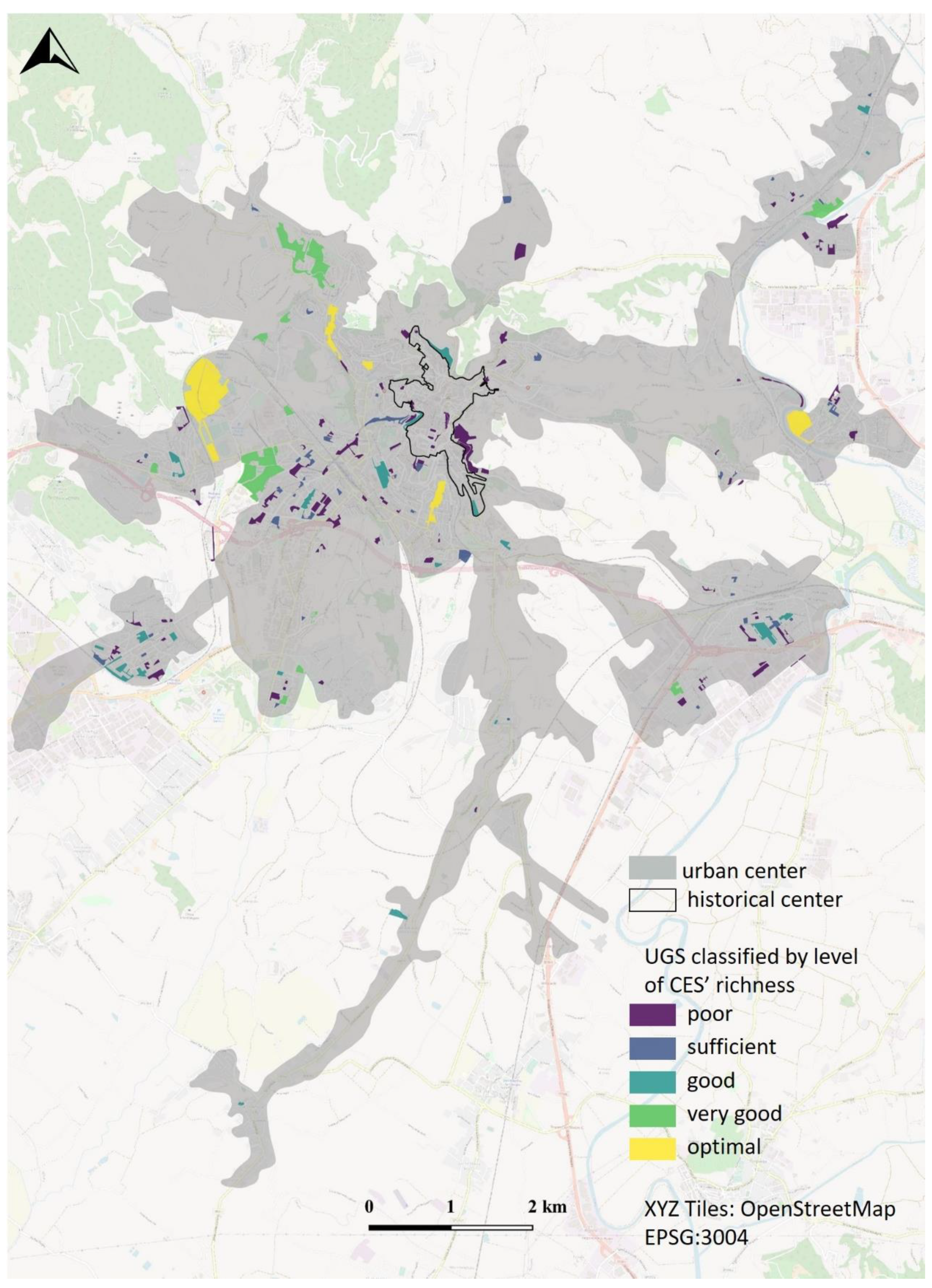
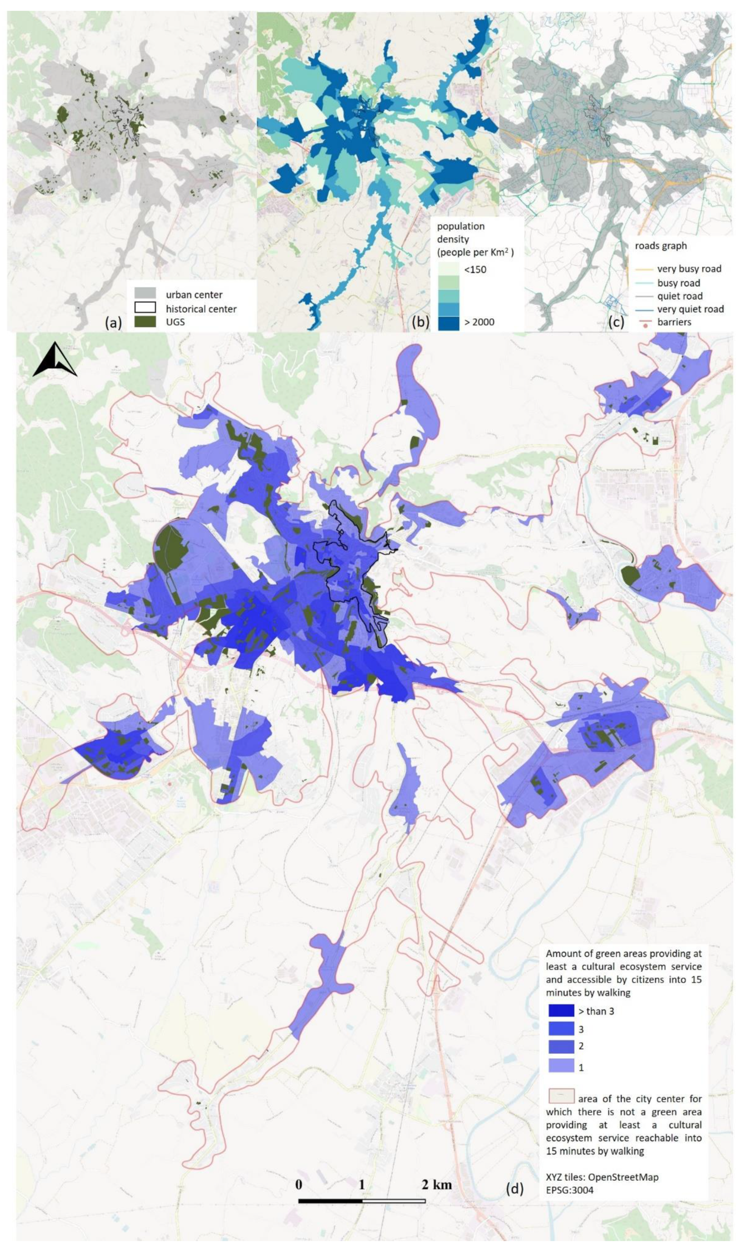
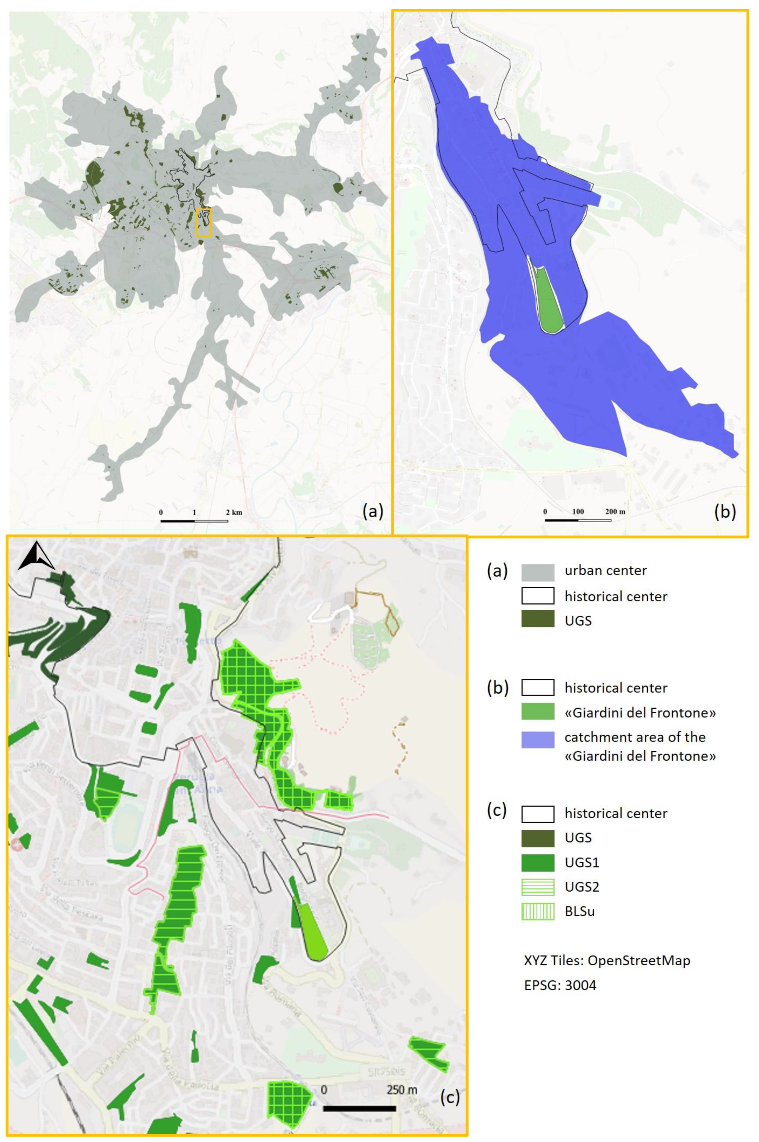
3.1. Results at the City Level

Figure 3 presents the GIS-dataset of Perugia city, composed of the urban green areas (a), the population census (b), and the road graph (c). The municipality of Perugia has 165,956 inhabitants, 101,548 of which live in the urban center. The urban green areas of the city center together measure 3,531,544 m2, giving each citizen an average of 34.7 m2 of urban green spaces. However, 46% of greenery is located along urban roads or near main public buildings and does not provide any furniture or equipment. With these spaces removed, the available area of equipped urban green spaces drops to 18.60 m2 per person. Furthermore, as shown in Figure 3d, some city zones have no accessible equipped green spaces. For this reason, 17.97% of citizens do not have access to any green areas that provide CES (Table 1).
Only 24% of citizens have ‘good’ access to a green area providing at least a ‘good’ level of equipment (green cells in Table 1).
Figure 4 shows that the variety of equipment has a divergent spatial distribution. Indeed, the city center has a high amount of green areas. Nonetheless, we found that many green spaces with highly ranked equipment are distributed on the edge of the urban center. In contrast, areas with poor equipment are concentrated in the city center.

3.2. Renewal of the Green Area “Giardini del Frontone”. Results at the Neighborhood and Green Area Levels

Figure 5 shows the study area and a map of the results.
“Giardini del Frontone” was the object of a participatory process aimed at its renewal and open to the 1065 citizens living in its catchment area (Figure 5b).
Requests for CES were provided by 108 people, 15 of which represented as many local cultural and commercial associations. Their ages ranged from 24 to 82 years old. First, we used Equation (1) to identify the other green areas accessible by the community settled in the catchment area of “Giardini del Frontone” (Figure 5c, UGS1).
The successive subsets of the method are CES-specific. In total, participants asked for 64 CES associated with the following themes: nature and water enjoyment, paths for physical activities, playgrounds, sports activities, spaces and stages for art performance and cultural events, and spaces for pets. Of all the proposals, 20% were nonviable for technical reasons.
Through field research, we noted that popular times and visit durations from Google were not representative of the effective use of the equipment. Nonetheless, this source of information proved useful in planning the first screening and determining the timetable for field research and finding people to interview.
Figure 5 reports the resulting subsets UGS2 and BLSu for one of the 64 CES studied (Figure 5c). These results concern a small stage for performances requested by three small-scale associations (an association of puppetry, a children’s theater, and an association of dialect theater). Generally, the inhabitants of the neighborhood are the audience of their performances.
The potential new users were evaluated using the typical number of viewers for the three associations and the participants in their courses.
The subset UGS2 (Figure 5c) groups existing areas with an attractive stage for performing and the subset BLSu groups two areas that have stages and enough space for potential new viewers to guarantee the physical distancing required during the present pandemic. These local associations were satisfied as they were made aware of unknown yet attractive and usable stages for performing through use of the method.
Of all of the requested CES, we suggested suitable alternative areas for 41% of the proposals, and 93% of the participants appreciated our method of selecting between proposals.

4. Discussion

The proposed method realizes a census of urban green areas at the city level, then selects the subset of accessible green spaces to evaluate the attractiveness of the available equipment in providing CES and then, for those found to be attractive, their usability. This method supports local communities’ decisions concerning selection of the ideal sites for equipment to provide CES by choosing among the available urban green areas. Inhabitants focus on the green areas to be designed or requalified, while experts assess the relationships between a studied area and others within the UGS. This method contributes to the effectiveness of the design solutions for a study area and, at the same time, allows inhabitants to better understand the consistency and variety of the UGS in their city. This is a first contribution to the overall enhancement of the UGS.
The main effort in the construction of the dataset is at the city level, so once the method is applied in an initial case study, the city-level data could easily be reapplied in successive analyses of other green areas in the same city.
The main weakness of this method is the concerted effort required of the municipality to produce a UGS census. In Italy, such a census has been required by law for cities with over 150,000 inhabitants since 2013 [48]. Since 2020, Italy’s legislation also addresses the minimum environmental criteria for managing urban green areas and defines three levels for the UGS census [49]. The first level geo-references the managed green areas. The second level consists of a register of the urban trees, and the third level is an in-depth analysis of the vegetation and the equipment provided by green areas. Even if local administrations struggle to provide the first two levels [50], our method could help municipalities to achieve the third.
Overall, this method helps public administrations to see urban green areas as complex systems and to consider this complexity in their planning, design, and management. Furthermore, this method could be adapted to enhance other urban spaces and provide common services, thereby helping local administrations and inhabitants to become aware of existing spaces and their services.

4.1. Discussion of the Case Study Results

Citizens of Perugia have 34.7 m2 of urban green spaces per person. The prescriptive minimum values established by Italian national law [51] relating to the availability of urban green areas are 9 m2 per person for proximity services (e.g., neighborhood greenery) and 15 m2 per person for services of general interest (e.g., large urban parks). Therefore, Perugia city achieves the prescriptive level of greenery. This is not an obvious result: Kronenberg et al. [25] demonstrated that some cities in Central and Eastern Europe do not achieve their prescribed green surface targets. Although Perugia as a whole has enough urban green areas, 17.97% of Perugia’s citizens do not have access to green areas with even minimal equipment, such as tables or benches. This finding of a lack of equipment in green areas is in accordance with the results of a worldwide review on factors shaping the provision of urban green areas [52].
In Italy, the National Statistical Institute performs an annual census regarding urban green areas in the main Italian cities [50]. This census evaluates the achievement of the minimum surface of urban green area per person as established by Italian law [51]. Our finding of uneven accessibility to green areas highlights how the National Statistical Institute’s data regarding the consistency of urban green areas [50] are not, in fact, useful in verifying target 7 of the Sustainable Development Goal 11 [27]. Indeed, the Italian statistics consider only the availability criterion, but not their accessibility.
The results from the neighborhood and green area levels offer site-specific and community-tailored solutions. Only 41% of the requested services for the study area were already available in a green area accessible to inhabitants and with attractive and usable equipment. This result reveals that citizens have limited knowledge of the CES offered by UGS and, therefore, may request a service that is already present and underutilized in an alternative area. Indeed, many participants affirmed that they usually go to the same park by habit without looking into other green areas that may offer their desired services. The proposed method offers a way for citizens to become familiar with the entirety of the UGS. Overall, 93% of participants appreciated our method of selecting among proposals; however, the older than 75 group preferred to give up on accessing a requested CES rather than visit a different green area that provides the requested service—even when the walk could be shorter than their regular one—indicating the strong influence of habits on choice, especially in older adults. This result confirms the findings of Artmann et al. [12].

4.2. Highlights of the Method in Considering the Complexity of the UGS

The first core theme when considering urban green systems, as outlined by our method, is the adoption of a multi-level approach. Urban green planners need a holistic understanding of relevant multi-spatial and multi-temporal scales to observe urban phenomena from multiple viewpoints. We developed a method to combine the CES requests of citizens for green areas with the evaluations of experts. The method uses five criteria applied at scales of ever greater detail to understand the synergies, conflicts, and complementary factors between the CES provided by UGS. In urban green infrastructure planning, Elliot et al. [42] suggested considering city-level goals and local-level benefits separately. Following their suggestions, we used the criteria of availability and accessibility at the city level, the criterion of attractiveness at the neighborhood level (the catchment area), and the criteria of usability and suitability at the green area level. At the city level, we used data from a census and OpenStreetMap. We relied on satellite images and field research at the neighborhood level, and, at the green area level, we conducted field research. The utility of the proposed system of criteria depends on the availability of data [10]. We used the municipal urban green census of the city of Perugia [45] as the main source of information.
The second core theme when considering urban green systems is the value of network analysis. Data from OpenStreetMap are free, and the process of their acquisition is simple and, to a large extent, automatic using GIS software [53]. At the same time, great effort was made to edit and organize the network and revise the classifications of roads. The barriers listed in these data are stairs, fast roads, and multi-lane crossings. We conducted further field research to verify other barriers (uneven sidewalks, slopes, fences, dangerous surroundings). Using safe roads, we evaluated the distances between green areas and residences. With all these data, our method calculates the catchment areas of every green space as the population living a maximum of a 15-min walk away using only safe roads without barriers. Our results confirm previous findings [13,14,54] that indicated network analysis is an effective approach to investigate interactions between variables. To achieve satisfactory results, we outlined the necessity of verifying the effectiveness of the available dataset and, eventually, editing it.
The criterion of accessibility outlines a third core theme when considering urban green systems: the need to evaluate the relationships that exist between the UGS with the external variables of the system. In line with the studies of other scholars [11,29,54], we used housing as an external variable. Other authors investigated the external relationships between the UGS and landscape patterns [15], land cover [52], urban infrastructure [19], other public spaces [21], public transport [13], and points of interest [5]. These authors considered the UGS to be composed of homogeneous variables without evaluating its internal heterogeneity, while our method considers this heterogeneity to compare different areas within the UGS.
This observation brings us to the fourth core theme when considering urban green systems: the need to evaluate the relationships between the internal variables of the system. Indeed, the UGS comprises extremely diverse areas providing a collection of CES interacting locally with each other in multiple ways [54]. Innovative approaches to urban green planning require solutions which evaluate the relationships between different areas of the UGS in regard to CES provision, such as which activities are catered to and in which spatial relations [41,55]. In our method, once the study area was selected (x1 in Figure 1), we used attractiveness and usability criteria to evaluate the relationships between it and other green areas. We used Google Images to realize a timely census of furniture and equipment, and then, similar to Biernacka et al. [10], conducted field visits. Only during these visits did we recognize the actual condition of the equipment and surroundings, and understand the real character of public events (concerts, festivals, open markets, sports events, etc.) held in the UGS to determine whether they might act as an attraction or a deterrent to prospective users. The second criterion used to evaluate relationships between green areas is their “usability”. This criterion is useful to understand if there is already underused equipment in other green areas that could benefit from increased use. This method evaluates alternative solutions before installing new equipment, thereby improving the efficiency of resource provision by public administrations. Therefore, this method could help to address the institutional barrier to improving the UGS due to a lack of funds [9]. Popular times, wait times, and visit duration data from Google Maps reveal which green areas received visits from the users [56] but do not report on the use of equipment. For this reason, we conducted field research to verify the spaces’ suitability for physical distancing. This field research can be time-consuming for everyone involved [41], but provides an in-depth understanding of the use of equipment. Findings are often limited in duration and frequency because users continuously change their activities [17]. For instance, during the COVID-19 pandemic, many scholars have indicated that the use of green areas has strongly increased [2,3,5,6,7], but constant monitoring is necessary to evaluate whether these demands will remain as high. For example, Derks et al. [57] demonstrated that visits to an urban forest in Bonn (Germany) dropped to pre-COVID levels after restrictions were lifted.
A fifth core theme is the need for a continuous evaluation of site-specific and community-led solutions using strategies of adaptation. Indeed, our method searches for solutions differentiated by green areas, type of equipment, and inhabitants of the neighborhoods. The flowchart presented in Figure 2 has loops to revise GIS data based on the new solutions implemented. As suggested by Foster [58], the developed method uses a complex systems approach combining divergent steps (building of dataset with information on internal and external variables) and convergent steps (analyzing and evaluating all relevant information to assist in making final decisions).

5. Conclusions

In recent sector legislation, Italian municipalities were identified as the keepers of urban greenery, despite suffering from a lack of funds and often administering historic cities where it is harder to plan appropriate interventions. Furthermore, during the COVID-19 pandemic, many cities have seen increased demands for CES provisioning in urban green areas. Although changes in governmental restrictions and rules could reverse this increased use, policy makers must make a trade-off between the changing needs of the population, CES planning, and historical urban structure maintenance. Therefore, they require decision-making tools to evaluate and compare design alternatives and, thus, make more informed choices. The method developed in this paper offers a GIS-based tool to optimize the design, renewal, or provisioning of CES in urban green areas. The optimization process uses network analysis and a multi-scale approach to evaluate connections between urban green spaces, equipment, citizens, and safe walking paths. Beginning with the demand for CES provisioning in a studied green area, the method offers a transparent and clear process to collect and choose solutions for individual green spaces in a holistic strategy that can also identify aggregate effects and emerging characteristics at the city level.

Author Contributions

Conceptualization, M.E.M. and D.G.; methodology, M.E.M.; software, A.S. and M.E.M.; validation, A.S., M.E.M. and D.G.; formal analysis, A.S.; investigation, A.S.; resources, D.G.; data curation, A.S.; writing—original draft preparation, M.E.M. and D.G.; writing—review and editing, M.E.M. and D.G.; visualization, M.E.M.; supervision, M.E.M.; project administration, D.G.; funding acquisition, D.G. All authors have read and agreed to the published version of the manuscript.

Funding

The research has been carried out within the CoSy Project (Cosy Thinking—Enhancing higher education on COmplex SYstems Thinking for sustainable development), co-funded by the Erasmus + Programme of the European Union. Project Number: 2020-1-SE01-KA203-077872 https://cosy.pixel-online.org/index.php (accessed on 25 October 2021). The European Commission’s support for the production of this publication does not constitute an endorsement of the contents, which reflect the views only of the authors, and the Commission cannot be held responsible for any use which may be made of the information contained therein.

Institutional Review Board Statement

Not applicable.

Informed Consent Statement

Informed consent was obtained from all subjects involved in the study.

Conflicts of Interest

The authors declare no conflict of interest and the funders had no role in the design of the study; in the collection, analyses, or interpretation of data; in the writing of the manuscript, or in the decision to pufblish the results.

References

  1. KEA European Affairs. The Impact of the COVID19 Pandemic on the Cultural and Creative Sector. Report for the Council of Europe. 2020. Available online: https://keanet.eu/wp-content/uploads/Impact-of-COVID-19-pandemic-on-CCS_COE-KEA_26062020.pdf.pdf (accessed on 5 September 2021).
  2. Sharifi, A.; Khavarian-Garmsir, A.R. The COVID-19 pandemic: Impacts on cities and major lessons for urban planning, design, and management. Sci. Total Environ. 2020, 749. [Google Scholar] [CrossRef] [PubMed]
  3. Honey-Rosés, J.; Anguelovski, I.; Chireh, V.K.; Daher, C.; Bosch, C.K.V.D.; Litt, J.S.; Mawani, V.; McCall, M.K.; Orellana, A.; Oscilowicz, E.; et al. The impact of COVID-19 on public space: An early review of the emerging questions—Design, perceptions and inequities. Cities Health 2020. [Google Scholar] [CrossRef]
  4. Menconi, M.; Heland, L.; Grohmann, D. Learning from the gardeners of the oldest community garden in Seattle: Resilience explained through ecosystem services analysis. Urban For. Urban Green 2020, 56, 126878. [Google Scholar] [CrossRef]
  5. Zhu, J.; Xu, C. Sina microblog sentiment in Beijing city parks as measure of demand for urban green space during the COVID-19. Urban For. Urban Green 2020, 58. [Google Scholar] [CrossRef]
  6. Ugolini, F.; Massetti, L.; Calaza-Martínez, P.; Cariñanos, P.; Dobbs, C.; Ostoić, S.K.; Marin, A.M.; Pearlmutter, D.; Saaroni, H.; Šaulienė, I.; et al. Effects of the COVID-19 pandemic on the use and perceptions of urban green space: An international exploratory study. Urban For. Urban Green 2020, 56. [Google Scholar] [CrossRef] [PubMed]
  7. Ma, A.T.; Lam, T.W.; Cheung, L.T.; Fok, L. Protected areas as a space for pandemic disease adaptation: A case of COVID-19 in Hong Kong. Landsc. Urban Plan. 2020, 207. [Google Scholar] [CrossRef]
  8. Menconi, M.; Tasso, S.; Santinelli, M.; Grohmann, D. A card game to renew urban parks: Face-to-face and online approach for the inclusive involvement of local community. Eval. Program Plan. 2019, 79. [Google Scholar] [CrossRef] [PubMed]
  9. Biernacka, M.; Kronenberg, J. Classification of institutional barriers affecting the availability, accessibility and attractiveness of urban green spaces. Urban For. Urban Green 2018, 36, 22–33. [Google Scholar] [CrossRef]
  10. Biernacka, M.; Kronenberg, J.; Łaszkiewicz, E. An integrated system of monitoring the availability, accessibility and attractiveness of urban parks and green squares. Appl. Geogr. 2020, 116. [Google Scholar] [CrossRef]
  11. Lahoti, S.; Lahoti, A.; Saito, O. Benchmark assessment of recreational public Urban Green space provisions: A case of typical urbanizing Indian City, Nagpur. Urban For. Urban Green 2019, 44. [Google Scholar] [CrossRef]
  12. Artmann, M.; Mueller, C.; Goetzlich, L.; Hof, A. Supply and Demand Concerning Urban Green Spaces for Recreation by Elderlies Living in Care Facilities: The Role of Accessibility in an Explorative Case Study in Austria. Front. Environ. Sci. 2019. [Google Scholar] [CrossRef]
  13. Chen, J.; Chang, Z. Rethinking urban green space accessibility: Evaluating and optimizing public transportation system through social network analysis in megacities. Landsc. Urban Plan. 2015, 143, 150–159. [Google Scholar] [CrossRef]
  14. Wanghe, K.; Guo, X.; Luan, X.; Li, K. Assessment of Urban Green Space Based on Bio-Energy Landscape Connectivity: A Case Study on Tongzhou District in Beijing, China. Sustainability 2019, 11, 4943. [Google Scholar] [CrossRef] [Green Version]
  15. Wang, B.; Liu, Z.; Mei, Y.; Li, W. Assessment of Ecosystem Service Quality and Its Correlation with Landscape Patterns in Haidian District, Beijing. Int. J. Environ. Res. Public Health 2019, 16, 1248. [Google Scholar] [CrossRef] [PubMed] [Green Version]
  16. Mahmoudkhani, M.; Feghhi, J.; Makhdoum, M.; Bahmani, O. Evaluation of the recreational capability and designing of the woodsy promenade. Environ. Dev. Sustain. 2020, 23, 8062–8075. [Google Scholar] [CrossRef]
  17. Dade, M.C.; Mitchell, M.G.; Brown, G.; Rhodes, J.R. The effects of urban greenspace characteristics and socio-demographics vary among cultural ecosystem services. Urban For. Urban Green 2020, 49. [Google Scholar] [CrossRef]
  18. Hong, W.; Guo, R. Indicators for quantitative evaluation of the social services function of urban greenbelt systems: A case study of shenzhen, China. Ecol. Indic. 2017, 75, 259–267. [Google Scholar] [CrossRef]
  19. Schäffler, A.; Swilling, M. Valuing green infrastructure in an urban environment under pressure The Johannesburg case. Ecol. Econ. 2013, 86, 246–257. [Google Scholar] [CrossRef]
  20. Subramanian, D.; Jana, A. Evaluating the cultural ecosystem services of India: Comparison of budget allocations to improve the use value of recreational open spaces. Ecosyst. Serv. 2019, 38. [Google Scholar] [CrossRef]
  21. Cilliers, E.J.; Timmermans, W.; Goorbergh, F.V.D.; Slijkhuis, J.S.A. The Story Behind the Place: Creating Urban Spaces That Enhance Quality of Life. Appl. Res. Qual. Life 2014, 10, 589–598. [Google Scholar] [CrossRef]
  22. Matasov, V.; Marchesini, L.B.; Yaroslavtsev, A.; Sala, G.; Fareeva, O.; Seregin, I.; Castaldi, S.; Vasenev, V.; Valentini, R. IoT Monitoring of Urban Tree Ecosystem Services: Possibilities and Challenges. Forests 2020, 11, 775. [Google Scholar] [CrossRef]
  23. Ferrini, F.; Fini, A.; Mori, J.; Gori, A. Role of Vegetation as a Mitigating Factor in the Urban Context. Sustainability 2020, 12, 4247. [Google Scholar] [CrossRef]
  24. MEA. Ecosystems and Human Well-Being: A Framework for Assessment; Island Press: Washington, DC, USA, 2005; pp. 25–36. [Google Scholar]
  25. Kronenberg, J.; Haase, A.; Łaszkiewicz, E.; Antal, A.; Baravikova, A.; Biernacka, M.; Dushkova, D.; Filčak, R.; Haase, D.; Ignatieva, M.; et al. Environmental justice in the context of urban green space availability, accessibility, and attractiveness in postsocialist cities. Cities 2020, 106. [Google Scholar] [CrossRef]
  26. Feltynowski, M.; Kronenberg, J.; Bergier, T.; Kabisch, N.; Łaszkiewicz, E.; Strohbach, M. Challenges of urban green space management in the face of using inadequate data. Urban For. Urban Green 2018, 31, 56–66. [Google Scholar] [CrossRef]
  27. United Nations. Goal 11. Make Cities and Human Settlements Inclusive, Safe, Resilient and Sustainable. Available online: https://sdgs.un.org/goals/goal11 (accessed on 16 October 2020).
  28. Hegetschweiler, T.; de Vries, S.; Arnberger, A.; Bell, S.; Brennan, M.; Siter, N.; Olafsson, A.; Voigt, A.; Hunziker, M. Linking demand and supply factors in identifying cultural ecosystem services of urban green infrastructures: A review of European studies. Urban For. Urban Green 2017, 21, 48–59. [Google Scholar] [CrossRef] [Green Version]
  29. Akpinar, A. Factors influencing the use of urban greenways: A case study of Aydin, Turkey. Urban For. Urban Green 2016, 16, 123–131. [Google Scholar] [CrossRef]
  30. Grunewald, K.; Richter, B.; Meinel, G.; Herold, H.; Syrbe, R.-U. Proposal of indicators regarding the provision and acces-sibility of green spaces for assessing the ecosystem service “recreation in the city” in Germany. Int. J. Biodivers. Sci. Ecosyst. Serv. Manag. 2017, 13, 26–39. [Google Scholar] [CrossRef] [Green Version]
  31. Koltsova, A.; Kunze, A.; Schmitt, G. Design of Urban Space at Pedestrian Scale: A Method for Parameterization of Urban Qualities. In Proceedings of the 2012 16th International Conference on Information Visualisation (IV), Montpellier, France, 11–13 July 2012; pp. 403–409. [Google Scholar] [CrossRef]
  32. Meerow, S.; Newell, J.P. Spatial planning for multifunctional green infrastructure: Growing resilience in Detroit. Landsc. Urban Plan. 2017, 159, 62–75. [Google Scholar] [CrossRef]
  33. Ragab, K. Quantitavive Evaluation of distribution and accessibility of urban green space. Case Study: City of Jeddah. Int. J. Geomat. Geosci. 2014, 3, 526–535. [Google Scholar]
  34. Kaczynski, A.T.; Schipperijn, J.; Hipp, J.A.; Besenyi, G.M.; Wilhelm Stanis, S.A.; Hughey, S.M.; Wilcox, S. ParkIndex: Devel-opment of a standardized metric of park access for research and planning. Prev. Med. 2016, 87, 110–114. [Google Scholar] [CrossRef] [PubMed]
  35. Kimpton, A. A spatial analytic approach for classifying greenspace and comparing greenspace social equity. Appl. Geogr. 2017, 82, 129–142. [Google Scholar] [CrossRef] [Green Version]
  36. Park, K. Psychological park accessibility: A systematic literature review of perceptual components affecting park use. Landsc. Res. 2016, 42, 508–520. [Google Scholar] [CrossRef]
  37. Łaszkiewicz, E.; Czembrowski, P.; Kronenberg, J. Can proximity to urban green spaces be considered a luxury? Classifying a non-tradable good with the use of hedonic pricing method. Ecol. Econ. 2019, 161, 237–247. [Google Scholar] [CrossRef]
  38. Ståhle, A. Sociotope mapping: Exploring public open space and its multiple use values in urban and landscape planning practice. Nord. J. Archit. Res. 2006, 19, 59–71. [Google Scholar]
  39. Richards, D.R.; Tuncer, B. Using image recognition to automate assessment of cultural ecosystem services from social media photographs. Ecosyst. Serv. 2018, 31, 318–325. [Google Scholar] [CrossRef]
  40. Zhang, S.; Zhou, W. Recreational visits to urban parks and factors affecting park visits: Evidence from geotagged social media data. Landsc. Urban Plan. 2018, 180, 27–35. [Google Scholar] [CrossRef]
  41. Heikinheimo, V.; Tenkanen, H.; Bergroth, C.; Järv, O.; Hiippala, T.; Toivonen, T. Understanding the use of urban green spaces from user-generated geographic information. Landsc. Urban Plan. 2020, 201. [Google Scholar] [CrossRef]
  42. Elliott, R.M.; Motzny, A.E.; Majd, S.; Chavez, F.V.; Laimer, D.; Orlove, B.S.; Culligan, P.J. Identifying linkages between urban green infrastructure and ecosystem services using an expert opinion methodology. Ambio 2019, 49, 569–583. [Google Scholar] [CrossRef] [PubMed]
  43. Demographic Statistic ISTAT. Available online: http://demo.istat.it/bilmens/index.php?anno=2020&lingua=ita (accessed on 5 September 2021).
  44. Martinico, F.; La Rosa, D.; Privetera, R. Green oriented urban development for urban ecosystem services provision in a medium sized city in southern Italy. iForest 2014, 7, 385–395. [Google Scholar] [CrossRef] [Green Version]
  45. Municipality of Perugia. Municipal Census of Urban green areas (Portale Ambiente). Available online: http://ambiente.comune.perugia.it/#Temi%20Ambientali (accessed on 5 September 2021).
  46. Population Census. Available online: https://www.istat.it/it/archivio/104317 (accessed on 5 September 2021).
  47. Fondazione Veronesi. Available online: https://www.fondazioneveronesi.it/magazine/articoli/cardiologia/un-buon-passo-fa-la-differenza-la-salute-di-un-anziano (accessed on 5 September 2021).
  48. Italian Ministry of Ecological Transition. L. 10/2013. Available online: https://www.mite.gov.it/sites/default/files/archivio/normativa/legge_14_01_2013_10.pdf (accessed on 5 September 2021).
  49. Italian Official Gazette. D.M. 63/2020. Available online: https://www.mite.gov.it/sites/default/files/archivio/allegati/GPP/2020/guri_dm_63_del_2020_verde_002.pdf (accessed on 5 September 2021).
  50. ISTAT. Urban Environment. Urban Greenery: Table 11.1 (Availability of Urban Green Area per Person). Available online: https://www.istat.it/it/archivio/236912 (accessed on 5 September 2021).
  51. Italian Official Gazette. DM 1444/68. Available online: https://www.gazzettaufficiale.it/eli/id/1968/04/16/1288Q004/sg (accessed on 5 September 2021).
  52. Boulton, C.; Dedekorkut-Howes, A.; Byrne, J. Factors shaping urban greenspace provision: A systematic review of the literature. Landsc. Urban Plan. 2018, 178, 82–101. [Google Scholar] [CrossRef]
  53. Ramn, F.; Topf, J.; Chilton, S. OpenStreetMap—Using and Enhancing the Free Map of the World; UIT Cambridge Ltd.: Cambridge, UK, 2014. [Google Scholar]
  54. Gerstenberg, T.; Baumeister, C.F.; Schraml, U.; Plieninger, T. Hot routes in urban forests: The impact of multiple landscape features on recreational use intensity. Landsc. Urban Plan. 2020, 203. [Google Scholar] [CrossRef]
  55. Menconi, M.E.; Palazzoni, L.; Grohmann, D. Core themes for an urban green systems thinker: A review of complexity man-agement in provisioning cultural ecosystem services. Urban For. Urban Green 2021, 127355. [Google Scholar] [CrossRef]
  56. Support Google. Available online: https://support.google.com/business/answer/6263531?hl=en# (accessed on 5 September 2021).
  57. Derks, J.; Giessen, L.; Winkel, G. COVID-19-induced visitor boom reveals the importance of forests as critical infrastructure. For. Policy Econ. 2020, 118, 102253. [Google Scholar] [CrossRef]
  58. Foster, K. Geodesign parsed: Placing it within the rubric of recognized design theories. Landsc. Urban Plan. 2016, 156, 92–100. [Google Scholar] [CrossRef] [Green Version]
Figure 1. Steps of the method at the city level.
Sustainability 13 11787 g001
Figure 2. Steps of the method at the neighborhood and green area levels.
Sustainability 13 11787 g002
Figure 3. Case study dataset: (a) UGS; (b) population census; (c) road graph; and (d) catchment areas using 750 m as the maximum walking distance (representing poor accessibility).
Sustainability 13 11787 g003
Figure 4. UGS classified by richness of CES.
Sustainability 13 11787 g004
Figure 5. Subsequent zooms to find accessible alternative areas (UGS1) that provide the requested service (a performing stage) in good condition (UGS2) that are currently underutilized (BLSu). (a) UGS; (b) catchment area of “Giardini del Frontone”; and (c) subsets for the dc “stage for performances”.
Sustainability 13 11787 g005
Table 1. Distribution of the percentage of the urban population having access to at least one urban green area providing CES, differentiated by level of accessibility and richness of CES. The cells colored in green represent the percentage of the population with ‘good’ accessibility to at least one green area with at least a ‘good’ richness of services.
AccessibilityGoodMediumPoorTotal
Services’ Richness
poor5.116.915.5117.53
sufficient15.828.473.3727.66
good6.392.12.9911.48
very good11.290.950.2912.53
optimal6.533.852.4512.83
Total45.1422.2814.61
% of the population with access to at least one green area providing CES82.03
% of the population without access to at least one green area providing CES17.97
Publisher’s Note: MDPI stays neutral with regard to jurisdictional claims in published maps and institutional affiliations.

