Article

Implementation of Indigenous Knowledge on Local Spatial Management: A Case Study in Orchid Island (Lanyu), Taiwan

Department of Geography, National Taiwan University, No. 1, Sec. 4, Roosevelt Rd., Taipei 10617, Taiwan
*
Author to whom correspondence should be addressed.
Sustainability 2021, 13(19), 10940; https://doi.org/10.3390/su131910940
Submission received: 4 August 2021 / Revised: 24 September 2021 / Accepted: 28 September 2021 / Published: 1 October 2021

Abstract

:
Spatial management consists of land property and land use management, both on land and in the ocean. From the perspective of ‘social-ecological systems’, local spatial management represented the resilience of adaptation that indigenous knowledge and environment change were interrelated. This study aims to extract critical components that contribute to the dynamic maintenance of the stability and sustainability of local spatial management. The indigenous knowledge of Yami people on Orchid Island was investigated as a case study to highlight how indigenous institutions functioned in a more suitable and adaptable way for local spatial management. Empirical data were collected by participatory mapping and an in-depth interview with indigenous experts. Differently from the official policy, the results show that the cultural-specific spatial regulations, including land ownership and land use, were strictly maintained with landscape structure and social organizations by the Yami indigenous institution. Local cultural spatial management with regulated and comprehensive institutions could cope with challenges immediately and dynamically, and enhance resilience more than official institutions that are simplified and controlled by the state. It is argued that spatial regulations, landscape structure, and social organizations from indigenous knowledge were recommended to be introduced into official spatial management institutions, to validate the values of indigenous knowledge and improve the resilience of local spatial management.

1. Introduction

In regards to the concerns of ‘social-ecological systems (SES)’, studies on the applications of indigenous knowledge have been conducted to verify how indigenous knowledge would contribute to generating resilience in environmental management [1,2,3,4,5,6,7]. Local ecological knowledge (LEK) and traditional ecological knowledge (TEK) were argued to be suitable approaches to deal with local environmental management and decision making [2,5,7,8,9,10].
Spatial management, especially in land management, comprising land ownership and land use management [11,12,13], usually maintained by indigenous practice, but controlled by government policy, demonstrates the different identifications of land resources [14,15,16]. The indigenous institutions generated from long-term adaptation might stabilize local land resource development. In regards to the concern of indigenous institutions for local spatial management, the Yami people of Orchid Island, Taiwan, are taken as the case study for various reasons. The Yami people are recognized as the tribe that maintains the most traditional culture of Taiwan amongst all indigenous people. Also, Yami people have still practiced the indigenous institution’s views on spatial management in the recent years. The uniqueness of Yami’s indigenous institution, therefore, is proposed to investigate in this paper.
Accordingly, this study focuses on the indigenous institution’s practice on land ownership and land use management. By analyzing Yami’s indigenous institution, the critical components affecting spatial management will be extracted. The interrelation among critical components will be discussed, to explain the way Yami people exercise local spatial management in a dynamically stable situation.
This paper is comprised of five sections. Relevant concepts regarding indigenous knowledge and spatial management are discussed in Section 2. Basic information about Yami people and Orchid Island research methods are introduced in Section 3. In Section 4, the Yami’s indigenous institutions are described to verify their influence on local spatial management. In Section 5, three main concepts of indigenous institutions are discussed to explain how they contribute to local spatial management. Challenges and recommendations are suggested at the end of this paper.

2. Indigenous Knowledge and Spatial Management

Indigenous knowledge has been recognized as an alternative approach to scientific knowledge, for dealing with environmental issues [1,2,3,4,5,15,16]. From the perspective of ‘social-ecological systems (SES)’, the implementation of indigenous knowledge could contribute to the generation of adaptive capacity or resilience [6,7,10]. The indigenous institution, therefore, represented the adaptation at a local level that would be suitable for coping with local environmental issues [17].
In contrast to the scientific approaches applied with governmental policy, the indigenous institution, composed of local knowledge, local social organization, and local belief, could be practiced more precisely and dynamically [18,19,20]. Moreover, the indigenous institution illustrated the decentralized management based on long-term adaptation [21]. It was important that the indigenous institution would provide a more sustainable and stable interaction in dynamic local management [22,23,24,25,26]. In terms of local spatial management, especially in land management, the processes that the indigenous institution contributed, to generate adaptive capacity or resilience, might involve a critical determinant. The major focus of this study is to figure out the key components that consisted in the indigenous institution and contributed to land management.
The meaning of spatial management can be understood by different disciplines, such as ecosystem management, natural resources management, land use management, and spatial plan, etc. [11,12,13,22,23,24,25,26,27]. This study concerned the indigenous institutions of land management, especially in land ownership and land use aspects. The interrelationship between land ownership and land use/cover has been discussed in previous research cases [12,13,28]. Markussen [28] proved that the status of land ownership would affect resource availability and depletion, and mentioned the importance of a local-level institution. Stanfield et al. [12] verified the correlations between patterns of land ownership and forest cover, and suggested the critical role of landscape structure and dynamic ownership institutions that contribute to land use management. Crow et al. [13] indicated that spatial heterogeneity was generated from ownership and ecosystem conditions that were expressed in land use patterns; hence, the relations among landscape structure, land ownership, and land use need to be taken into account to realize the way that the indigenous institution is enhancing spatial management in a sustainable way.
In regards to the concern of local spatial management, indigenous knowledge, resilience, and the institution will be investigated through a case study on Orchid Island, Taiwan. The principal components of sophisticated composition among these concepts need to be extracted to facilitate the cooperation and innovation of local spatial management.

3. Case Study: Yami Indigenous People and Orchid Island

3.1. Background and History

Orchid Island is a 45 km2 volcanic island that is located in the southeastern region of Taiwan. The six communities that are settled around the island include the Iraraley in the north, the Yayo in the northwest, the Iratay and Imowrod in the southeast, and the Iranmeylek and Ivalino in the east (Figure 1).
The indigenous residents of Orchid Island are called the Yami people, with a population of approximately 5000. Orchid Island was announced to be a part of Taiwan; therefore, it is important to note its political relations with Taiwan from the early 20th century until recently. It was colonized by imperial Japan during the period 1897–1945, before being transferred to being under the authority of R.O.C. (Taiwan), where it remains today [29].
Apart from the similarity of its history with that of Taiwan, some of the unique aspects of Yami people need to be addressed. First, the Yami people are the only indigenous tribe of Taiwan that live on an island with relative isolation; Taiwan’s other indigenous tribes all live in Taiwan’s mountain, plain, or coastal areas, and thus have more connections with the Taiwanese society than Yami people. Moreover, due to their isolation from Taiwan, the Yami people were the last tribes to be introduced to modern governance (in 1967), meaning that a relatively complete traditional culture has been maintained [30,31]. Before this, the Yami people were strictly controlled by the Taiwanese military and maintained a traditional culture, while other Taiwanese indigenous tribes were asked to change their lifestyles. Third, the Yami people’s land is composed of both terrain and marine areas, and they still practice farming and fishing traditionally. Accordingly, the indigenous knowledge of the Yami people could be observed and investigated more clearly in the field of local spatial management. In sum, the Yami people are recognized as the most significant indigenous tribe of Taiwan, and one that still practices most of the traditional culture today [32,33,34].
Traditionally, a year for the Yami people is divided into 3 seasons over 13 months based on the flying fish, providing the Yami people with ‘time–behavior regulations’ that are based on the traditional calendar [32]. As such, the Yami people live according to these restrictions, which are represented in their housing, cultivation, irrigation, forestry, and fishing, where these activities were practiced both on land and in the ocean. Therefore, the Yami’s indigenous knowledge could be summarized in a system consisting of ‘time–behavior regulations’ (3 seasons over 13 months) and ‘space–behavior regulations’ (housing, cultivation, irrigation, forestry, and fishing). Thus, the traditional Yami calendar is used to define ‘time–space–behavior regulations’ for all the Yami people on Orchid Island [32,33,34].

3.2. Method

This study was conducted through a participatory approach. To obtain the elements of landscape structure of the Yami people, participatory mapping was applied to clarify diverse land cover types and the structure of space. Additionally, an in-depth interview was applied to investigate critical components in regard to land ownership and land use institutions. Interviewees were the elders and indigenous experts with much experience in the Yami cultural practice. Also, the participatory observation provided empirical evidence on land ownership status and land use patterns from a particular landscape structure. A combination of collected data and literature was used to interpret the local spatial management implementation of the Yami people on Orchid Island.

4. Yami’s Local Spatial Management

Based on ‘time–space–behavior regulations’ from the traditional calendar, the Yami people evolved a complicated indigenous institution for dealing with land management. By following the regulation of ‘landscape structure’, ‘land ownership’, and ‘land use’, the Yami people have maintained an indigenous institution as their local spatial management.

4.1. Landscape Structure
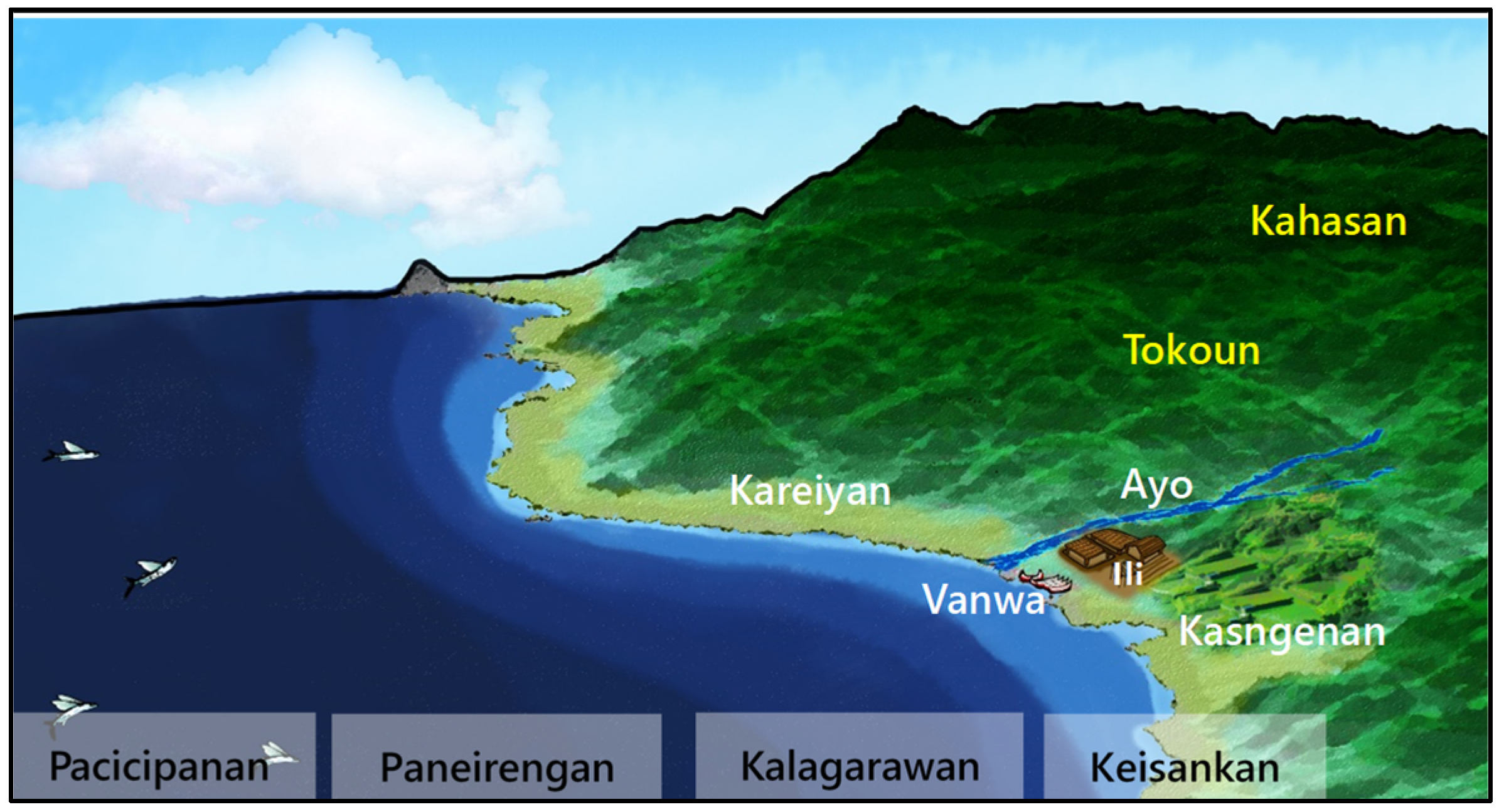
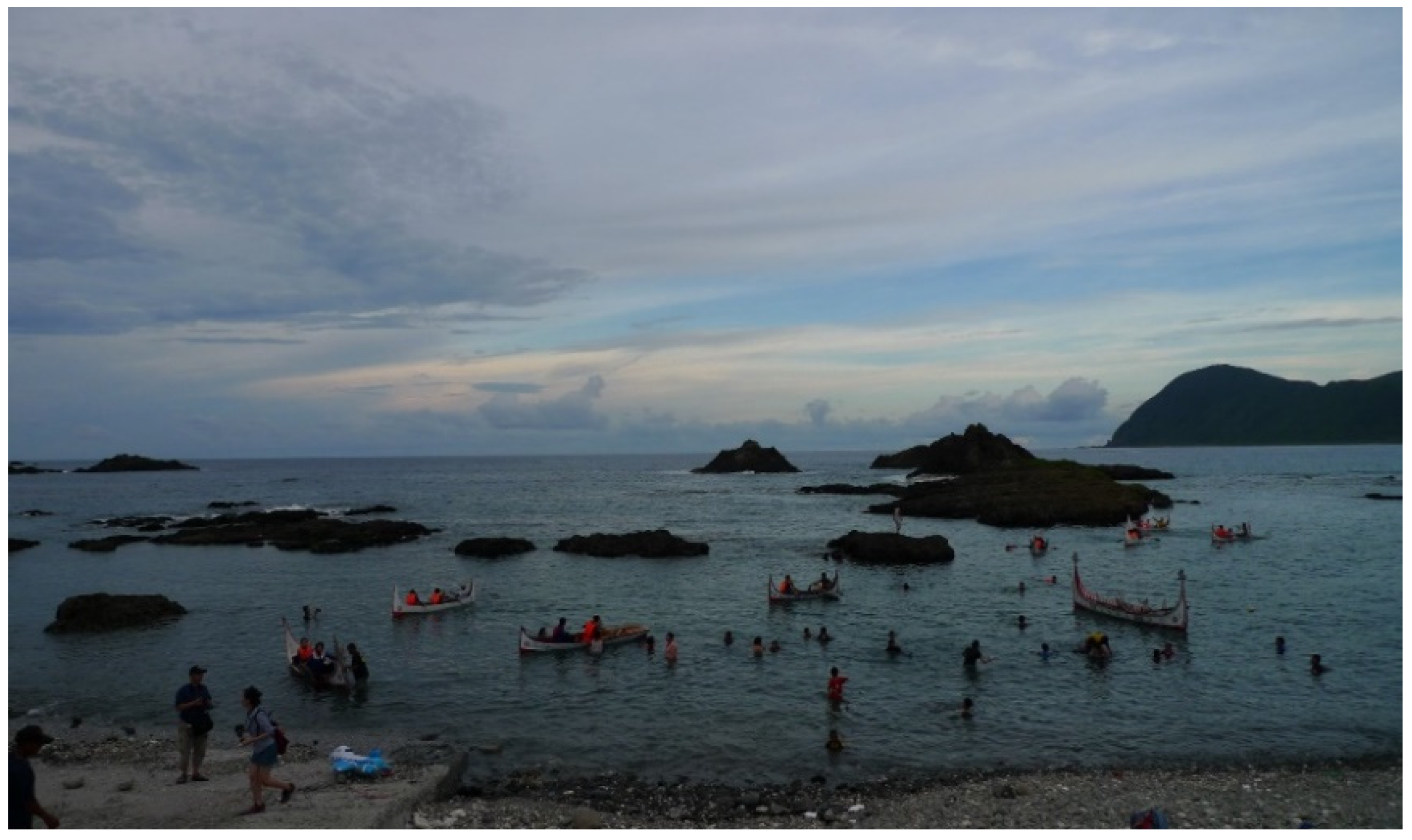
The landscape structure of the Yami people is not only physical, but also cultural. The physical environment of Orchid Island can be divided into the following four realms: ocean, main beach, settlements, and forest. Each of them were practiced in a different environmental site and functioned in specific regulations [35].

4.1.1. Ocean

The ocean refers to all the coastal line and marine area, which can be divided into the following four sections: Keisankan (foreshore for collection), Kalagarawan (sea for swimming/shooting), Paneirengan (sea for small boat fishing), and Pacicipanan (aea for large boat fishing) (Figure 2). Each of these areas is defined by cultural fishery types with different behavioral regulations [33,35].

Keisankan (Foreshore for Collection)

The Keisankan, the foreshore area, is the frontier between the land and the sea. In Yami culture, it is restricted to the collection of substances, such as small fish and shellfish, by women and is forbidden for any other utilization. This suggests that the Yami people have spatial behavioral rules to maintain the stability of natural resource provision at this location.

Kalagarawan (Sea for Swimming/Shooting)

The Kalagarawan, known as the shallow sea, refers to the area that is used for swimming/fishing (shooting) and is restricted to the Yami’s male. The boundary of Kalagarawan is defined as the distance that can be approached by swimming. Thus, the Kalagarawan is the closest marine area, with swimming/shooting regulations, to the land.

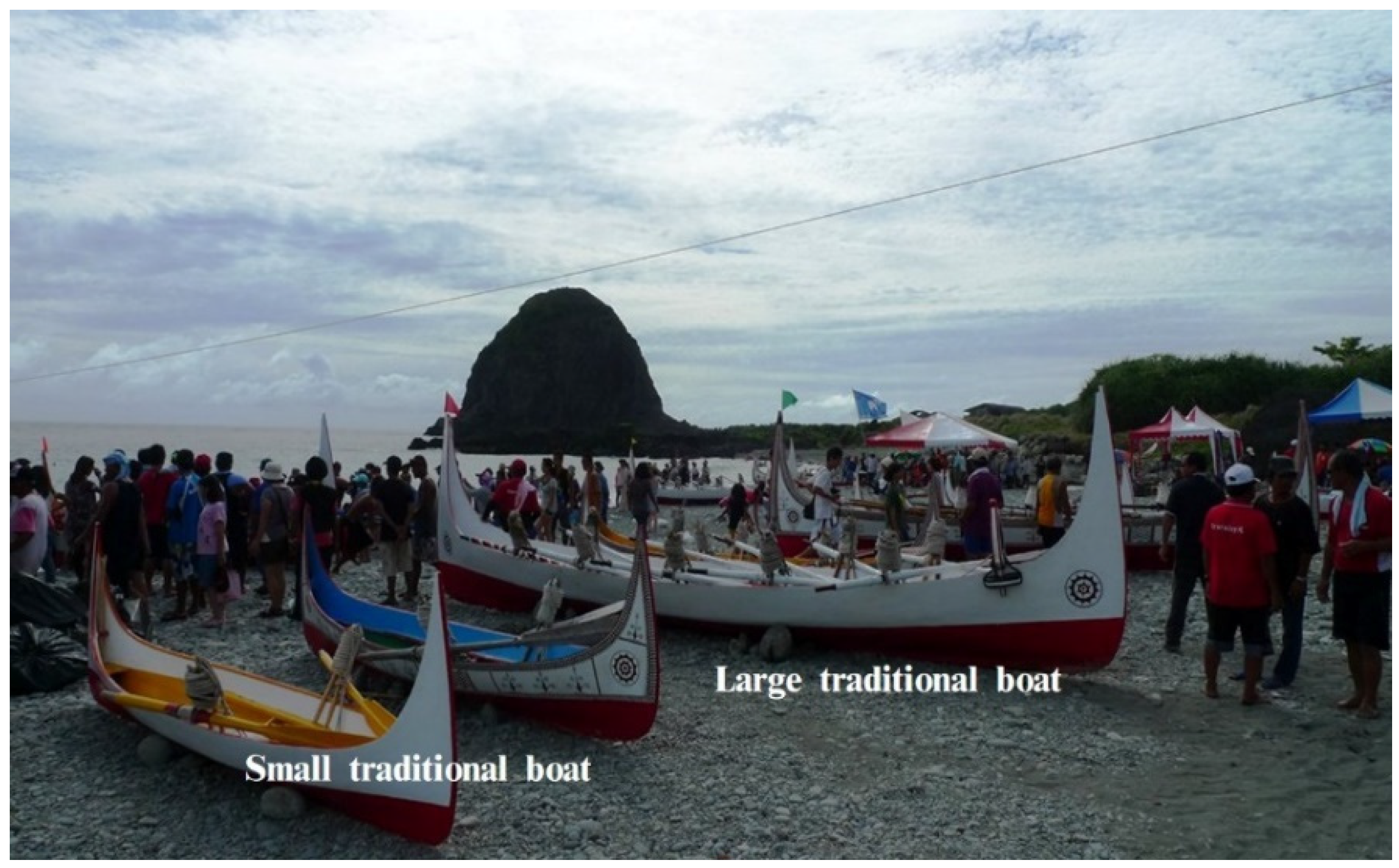
Paneirengan (Sea for Small Boat Fishing)

The Paneirengan is the marine area that is used for traditional small boat fishing. This area might be larger and wilder than the Kalagarawan because of the utilization of different equipment in fishing. In the Paneirengan, Yami men capture fishes by using a smaller traditional boat (Figure 3). These boats allow the Yami men to navigate to farther and wilder marine areas to catch larger schools of fish. As a result, this area can only be approached through the fishery by a small boat.

Pacicipanan (Sea for Large Boat Fishing)

The Pacicipanan is the most remote area of the ocean that is restricted to catch flying fish by using large traditional boats (Figure 3). In the season of catching flying fish (February to June), it is prohibited to catch species other than flying-fish in this marine area. The utilization of the Pacicipanan marine area is, therefore, strictly regulated to a specific period, specific fish species, and specific fishing behavior.
The classifications of the ocean areas in Yami indigenous knowledge, from the Keisankan to the Pacicipanan, illustrate the differences in marine resource utilization, represent the diversity of behavioral regulations, and indicate the institutions that Yami people use to maintain marine resources.

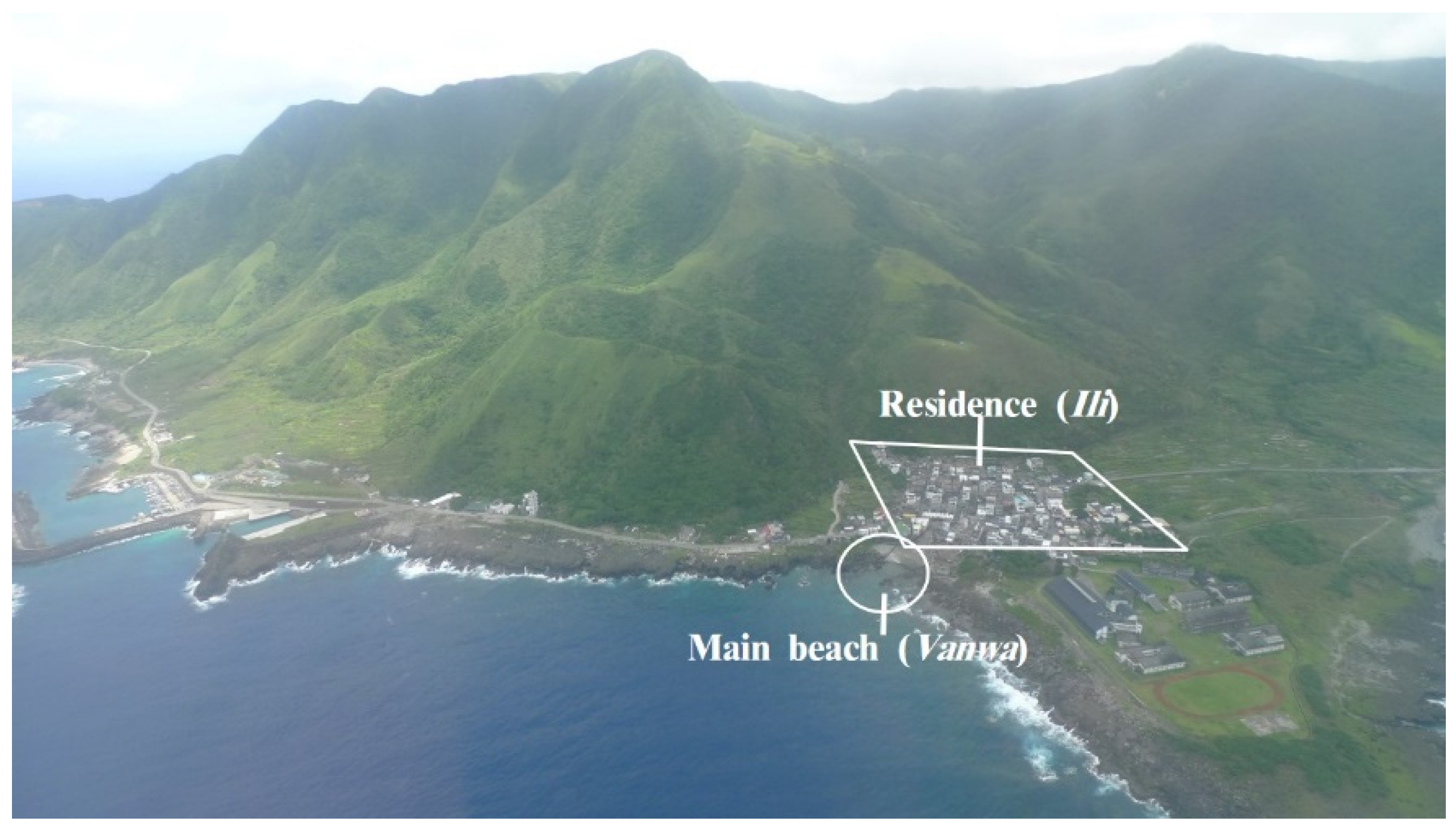
4.1.2. Main Beach (Vanwa)

The main beach is the natural port where the Yami’s traditional boats stay. It is a sacred site with rituals and ceremonies carried by each village, called Vanwa (Figure 4). The Vanwa, thus, is recognized as the connection between terrain and marine areas. There might be several natural beaches that exist along the coastline of a village, but only one would be designated and treated as the Vanwa with cultural interpretation.

4.1.3. Settlement

In Yami culture, a settlement (village) refers to all the terrain areas, except for the forest. The settlement consists of the following four parts: Ili (residence), Kasngenan (taro field), Kareiyan (farmland), and Ayo (river, irrigation).

Ili (Residence)

An Ili is a place for housing. In general, there is only one Ili in a settlement where all the houses are gathered (Figure 5). Traditionally, only places in/close to Ili could be identified as housing land, while others are all recognized as inappropriate. Accordingly, the demand for inhabitation is restricted in Ili rather than other places.

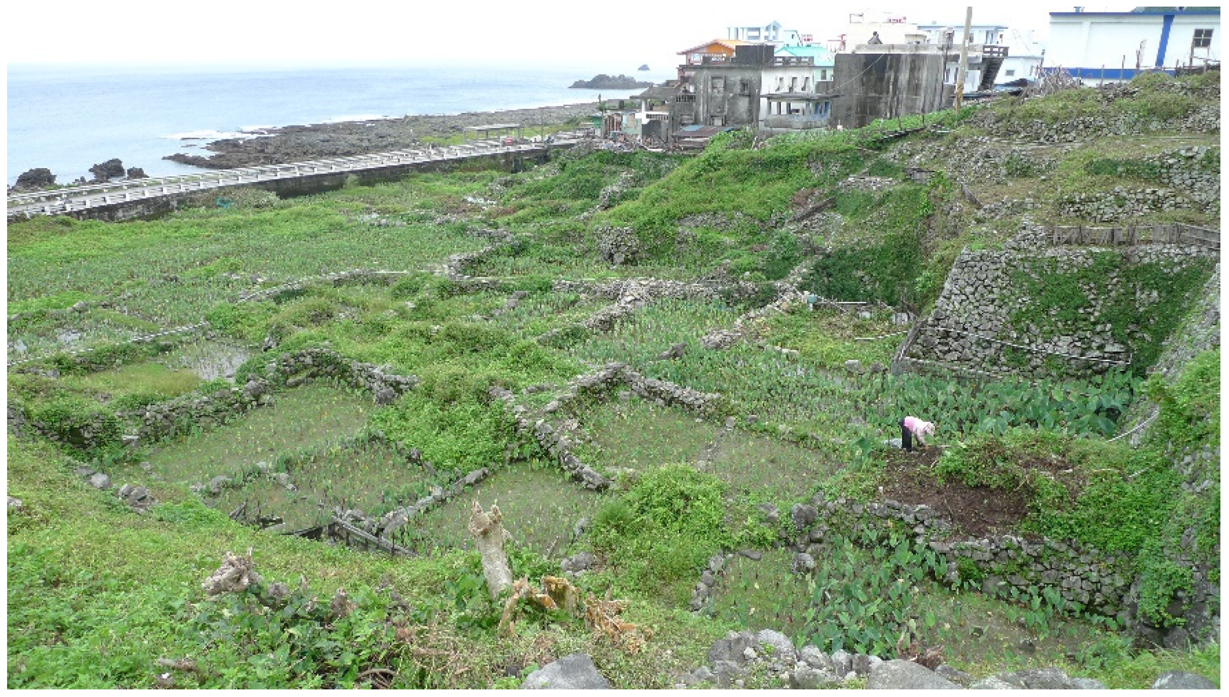
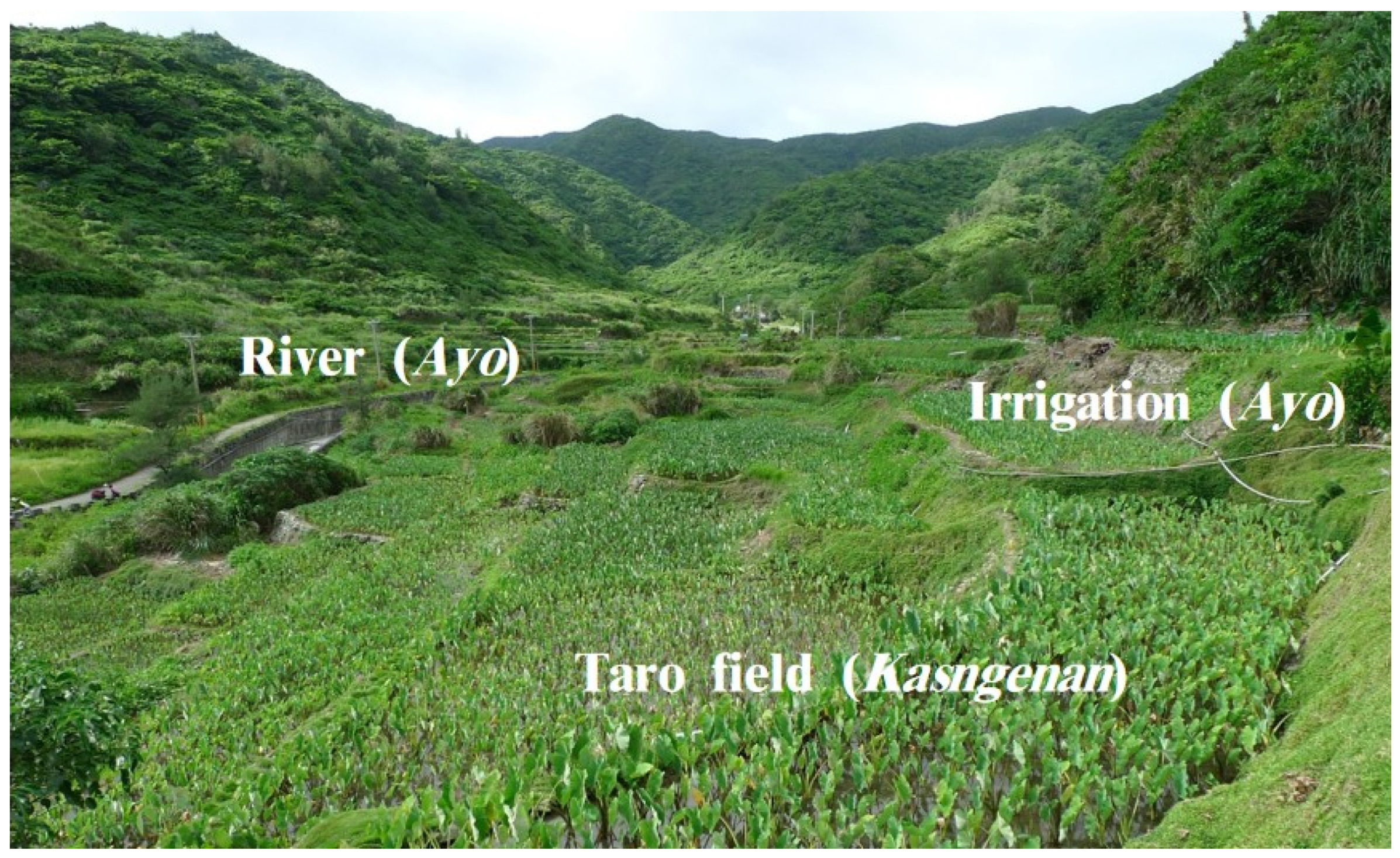
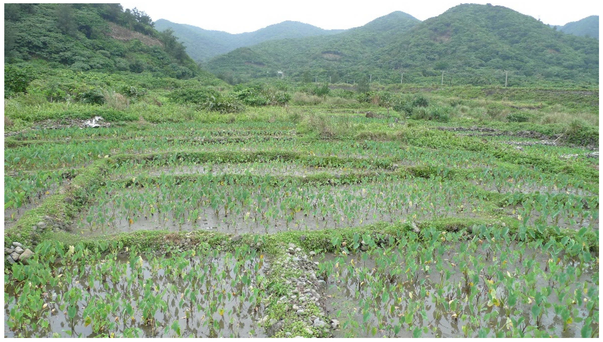
Kasngenan (Taro Field)
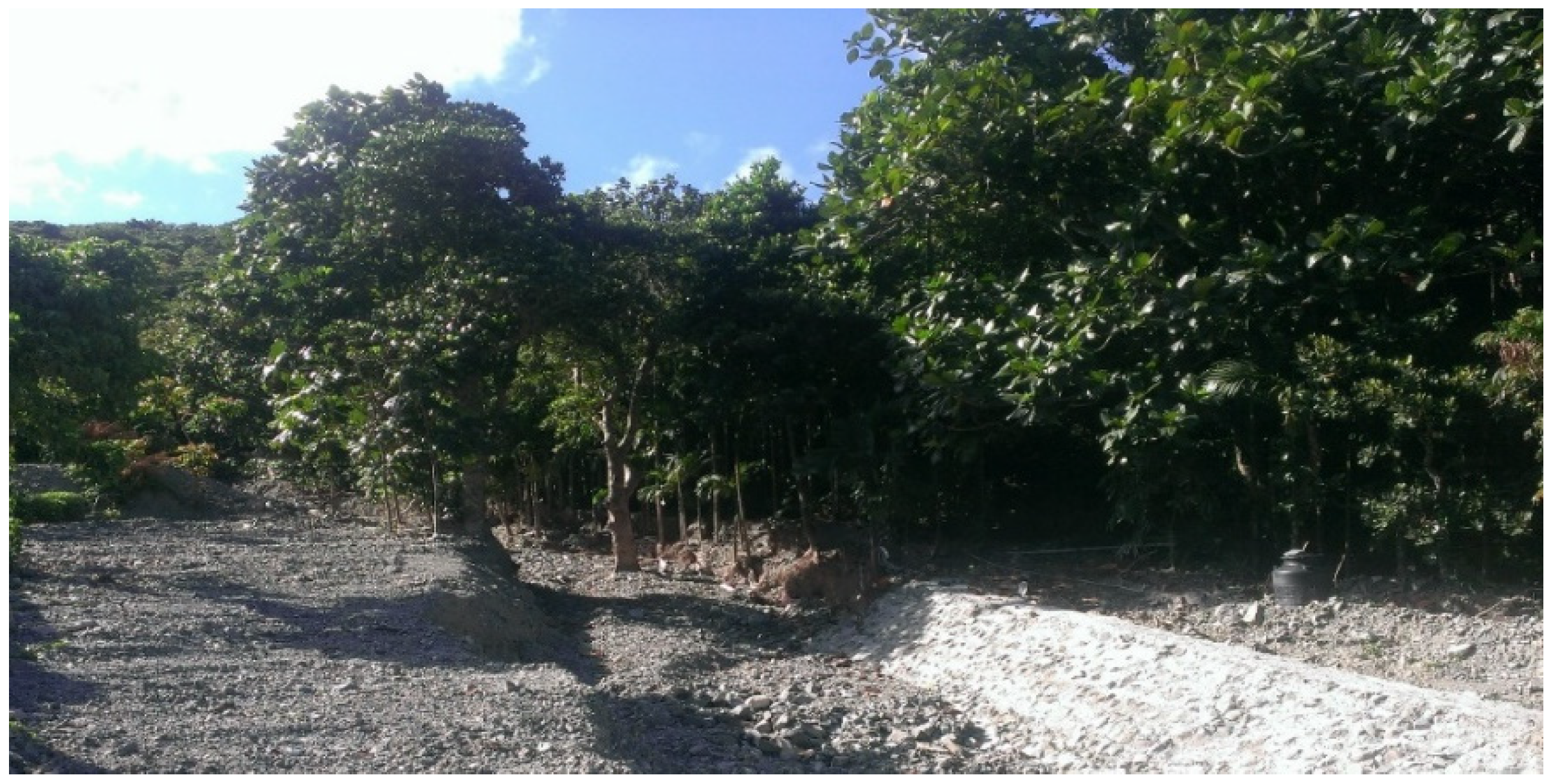
A Kasngenan (taro field) is a field for taro cultivation only, and is the most important area for local food provision. Usually, it is located close to the Ili area and is always managed by a Yami female, who carries the main responsibility of food production (Figure 6).

Kareiyan (Farmland)

A Kareiyan is farmland that is used for planting sweet potato, millet, or any crops except taro (Figure 7). Similarly to a Kasngenan, Kareiyan is mainly managed by a Yami female, but has diverse options for food cultivation.

Ayo (River, Irrigation)
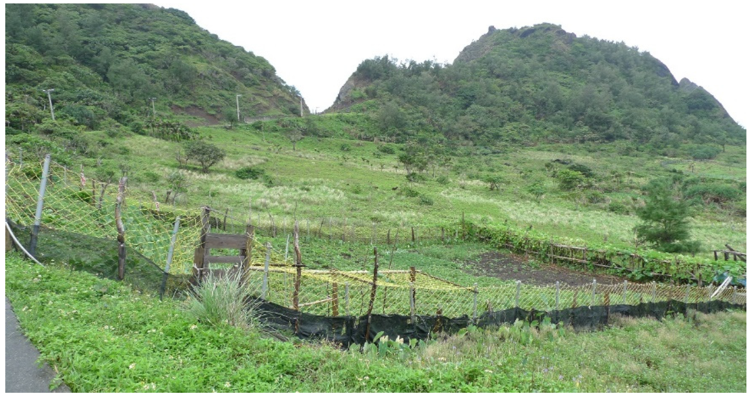
In Yami culture, the Ayo stands for the following two different elements with relevant functions: river and irrigation. In general, the river acts as a natural border that is used to identify boundaries between two villages. In addition, it provides water resources for both daily usage and taro field (Kasngenan) irrigation (Figure 8). The Ayo (river, irrigation), practically, is utilized as two different, but related, elements with unique management regulations.

4.1.4. Forest

The forest of Yami culture is composed of the following two types: Tokoun (close forest) and Kahasan (remote forest). The types of forest are not only distinguished by distance, but also by cultural recognition.

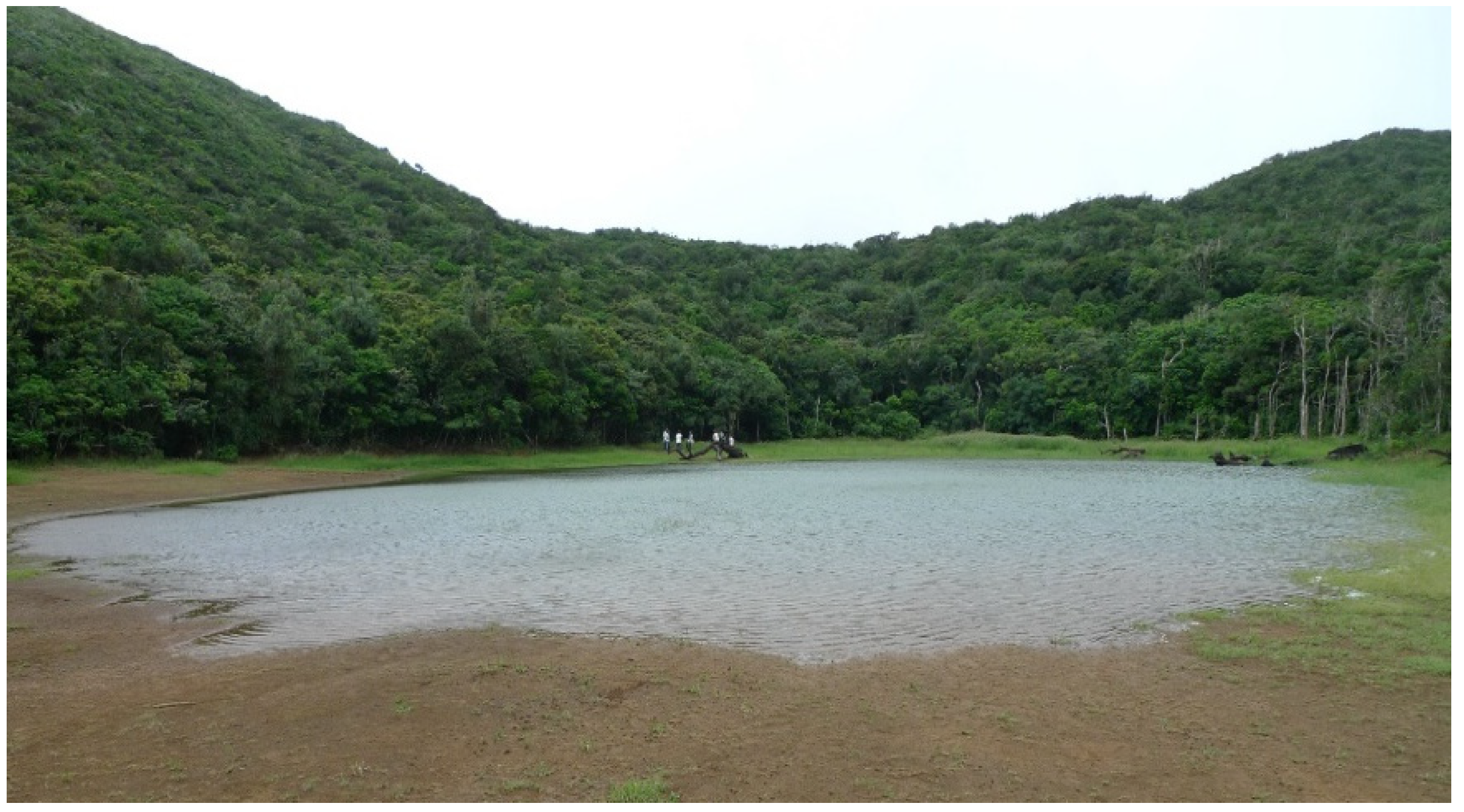
Tokoun (Close Forest)

A Tokoun is a forest that is located relatively close to a settlement where trees are harvested for Yami’s routine production, such as traditional houses and boats (Figure 9). Furthermore, the cultural definition of Tokoun is a forest that can be utilized by Yami people, with regulated management.

Kahasan (Remote Forest)

Differently from the Tokoun area, a Kahasan is a forest located in a more remote area, at an increased distance from the settlement [Figure 10]. In contrast to Tokoun, the Kahasan is considered as a forest that is utilized and owned by nobody. In other words, the Kahasan is a forest without any human intervention; it belongs to nobody but natural spirits and is protected by traditional taboos as a spiritual space.
In summary, the landscape structure in Yami indigenous knowledge comprises four main sections (the ocean, main beach, settlement, and forest) and 11 sub-partitions (elements) that indicate diverse regulations (Figure 11). The regulations of the Yami’s landscape structure, especially, demonstrates the Yami’s unique land ownership and land use institutions. The uniqueness of the land ownership and land use institutions are presented in the following sections.

4.2. Ownership

4.2.1. Combination of Landscape Structure and Social Organizations

Based on the landscape structure, Yami indigenous knowledge has developed an ownership management system that is in association with social organization. In Yami culture, individual (person), family (kinship-based group), and community (region-based group) are the fundamental levels of social units that are represented in different types of ownership.
The landscapes of Orchid Island would be divided into three levels, as ‘individual–family–community’, and would be defined as private (individual–private, family–private) and communal (community–communal) [36]. For instance, Kasngenan (taro field) is an absolutely private property that is owned by an individual or one family, and is distinguished by the border of laid stone (Figure 12). In contrast, the ocean definitely has communal ownership for one community, allowing everyone of the same community to approach it (Figure 13).
As mentioned, each element of the landscape structure is linked to levels of social organization to clarify their ownership status. Accordingly, the Yami’s land ownership regulations are constructed from the combination of landscape structure and social organization.

4.2.2. Variety of Land Ownership

Private and communal are the most general ownership statuses for land property on Orchid Island. Apart from private and communal, there are still some unique ownership statuses, such as ‘owned by nobody’, ‘temporarily private’, and ‘superficially private’, which existed in Yami’s society.
The land owned by nobody is different to communal land. It usually stands for a place with religious meaning or, to restrict taboo, a place that has been specified as a scared site [18,37]. Traditionally, the Kahasan (remote forest) is recognized as a forbidden place by traditional taboo and is identified as a nobody-owned area (Figure 9).
Besides, a land property defined as temporarily private suggests that the land ownership could shift from communal to private and would return to communal by the end of its utilization. It is treated as land with dynamic ownership for short-term development purposes, and is mainly in Kareiyan (farmland) for agriculture.
Third, a land with ‘superficially private’ ownership demonstrates a superficial property that exists on communal land. In this study, the Yami people designate ‘superficially private’ ownership by carving symbols on trees in the Tokoun (close forest) area only (Figure 14). Therefore, the marked timber is claimed as private, while the forest that the tree inhabits is still recognized as communal property.
In sum, the land ownership of Orchid Island could be classified into five patterns of practice, with the combination of landscape structure and social organization (Table 1).
In Table 1, the communal ownership type stands for a land property owned by the community as a common property. The ocean (four elements), ili (residence), Kareiyan (farmland, common area), Ayo (river), and Tokoun (close forest, common area) are all recognized as common property, which indicates that these landscapes would be available and accessible for residents in the same community.
Private ownership refers to private property that is possessed by a person or one family. The Kasngenan (taro field), some Kareiyan (farmland), the Ayo (irrigation parts), and some Tokoun (close forest) are typically private properties in Yami society. Accordingly, these properties are only utilized by an individual or one family.
The land that is ‘owned by nobody’ is the Kahasan (remote forest), as there is common recognition that it is a forbidden area with taboo. As a result, the Kahasan is a sacred site for all Yami people and nobody can announce possession of it.
‘Temporarily private’ is a specific ownership type in which a communal property would temporarily shift to a private one during a specific period (usually 3–5 years), as defined by Yami custom. It only occurs for Kareiyan (farmland), as the property ownership of a planted area can change from communal to private when someone starts to cultivate it. After 3 years of harvesting, the ownership of the planted area would return to being ‘communal’ and anyone from the community could access it again.
Another special ownership type is ‘superficially private’, which only happens in the Tokoun (close forest) area, normally to indicate the possession of a tree. Yami people can only select and claim the possession of trees, when accessing the communal Tokoun area, by marking their family symbol on it. This symbol represents ‘superficially private ownership’, as a form of identification for Yami people to evaluate. The possession of a tree will carry on until the tree falls.
In short, the ownership types within Yami culture suggest a complicated and diverse system that is based on landscape structure and social organization. Each of the spatial elements is associated with its corresponding ownership status, to guide Yami people in dealing with property management through different social organization levels. Yami ownership management, which combines landscape structure and social organization, represents the implementation of indigenous institutions, and also provides an empirical experience that enhances resilience in local spatial management.

4.3. Land Use

Apart from land ownership management, the Yami people simultaneously developed a land-use category based on landscape structure and social organization, in accordance with the Yami people’s spatial behavioral patterns [32,33,35,36].

4.3.1. Land-Use Categories

The land-use categories of the Yami people are constructed from landscape structure (elements), with different and suitable land use regulations.
In this concern, the landscape of Orchid Island was classified into four spatial types within 11 elements of diverse and distinct land use behavior regulations (Table 2).
The various types of fishing carried out in the ocean, for instance, are divided into the following four behavior patterns: collection in the Keisakan, shooting fishing in the Kalagarawan, small boat fishing in the Paneirengan, and large boat fishing in the Pacicipanan. These types illustrate distinct land use limitations with different levels of accessibility. The integration of landscape structure and accessibility of social organization has thus identified the appropriate land use regulation in a concrete institution.

4.3.2. Land Use Regulations

According to the investigation on Orchid Island, land use regulations were generated from the combination of landscape structure and social organization. In Yami culture, land ownership and land use accessibility are interrelated. In this concern, private property means that only a particular individual or family member could access it, while a communal land property allows members of the same community to approach it. Accordingly, the accessibility of social organization and a land use pattern are associated with landscape structure to construct particular land use regulations.

4.4. Yami’s Indigenous Institution for Local Spatial Management

In association with land ownership and land use regulations, the Yami culture evolved comprehensive spatial management. This demonstrates the value of the indigenous institution, and especially indicates the importance of landscape structure and social organization.
In terms of land ownership management, the Yami’s indigenous knowledge precisely identifies the types of possession of different landscape structures (elements) to form an obvious framework on property definition for Yami people to implement. In regards to land use management, the Yami’s indigenous knowledge developed a cultural land use restriction that ensures that land resources are maintained appropriately by everyday exercises.
By practicing spatial regulations on land ownership and land use management, actors from different levels of Yami’s social organization have reinforced the influence of their indigenous institution. In other words, practical implementation of local spatial management not only reinforces the robustness of Yami’s indigenous institution, but also increases the resilience of local spatial management, by conducting a regulated and comprehensive institution.
Landscape structure and social organization are not merely fundamental elements of Yami’s indigenous institution, but also the principal determinants affecting the identification of land ownership and land use patterns. These two components are the key factors that the indigenous institution can use to achieve local spatial management, while governmental policy may not conduct it in the same way.
In sum, the study on Orchid Island represents the integration of landscape structure and social organization, introducing spatial regulations on land ownership and land use management. The association of them could be recognized as indigenous institutions of local spatial management. In this concern, a comprehensive and regulated institution reflects the close relation and frequent interaction between landscape structure and social organization. It also indicates the intensive combination between Yami indigenous culture and the Orchid Island environment. Consequently, local spatial management is an aspect of social-ecological systems. The indigenous institution for spatial management is the reason for the resilience in land management. The sophisticated institution reflects the completeness that Yami people can achieve, while the strict regulations refer to the stability that Yami people can maintain.

5. Conclusions

5.1. The Role of Landscape Structure, Social Organizations, and Spatial Regulations

In this study, three critical components (landscape structure, social organization, and spatial regulation) are identified to demonstrate the contribution of indigenous knowledge to local spatial management.
Landscape structure, four types (ocean, main beach, settlement, and forest) are mentioned in this study, is the environmental foundation on which indigenous knowledge is converted to construct specific regulations. This regulation instructs all the spatial patterns by Yami’s traditional custom and maintains the diverse landscape of Orchid Island in a dynamically stable distribution.
Social organizations, the individual, family, and community level, are the units of land rights. This stands for the various accessibilities of different landscapes, and reflects the levels that Yami people have produced for land management decisions.
Spatial regulations, restrictions for land ownership and land use management, are the local-level integration of landscape structure and social organization. This represents the resilience to stabilize spatial development in a dynamic way, and demonstrates the capability of local spatial management to contribute to indigenous self-management.
The association of these three crucial components facilitates the implementation of the Yami indigenous institution, and reinforces the practice on the local spatial management of Orchid Island. The stability of the indigenous institution, therefore, is another important issue that needs to be faced, especially in the challenges when other institutions are introduced to Orchid Island.

5.2. Challenges and Further Recommendation

In the case study of the Yami people, the implementation of local spatial management relies on the following two additional conditions: the limited scale of implementation and the independence from other interventions.
The scale of spatial management is absolutely based on the extent to which resilience can apply. Yami’s resilience emerges in Orchid Island and could be conducted appropriately at the local scale. The stability of Yami’s indigenous institution, hence, is established with local-scale practice. Moreover, the relatively independent situation improves the stability of Yami’s institution compared to other-scale interventions. The inconsistency in geographical, political, and economical aspects between Taiwan and Orchid Island led the Yami society to obtain more flexible and independent space, to avoid interventions from the government, free market, and from interruption from others.
Unfortunately, the strength of the Yami people has been getting lost recently. Practically, spatial management (land ownership and land use) in Taiwan has been government centralized, and has encountered conflicts with indigenous communities for decades. The Yami people, in the past, successfully defeated governmental policy through collective resistance on land management. In other words, the Yami people chose to use indigenous institutions instead of following the official land management policies, by making collective land management decisions for decades. However, recently, governmental policy has been imported into Orchid Island through the free market, with benefits from the economy. The strength of Yami’s institution, both at a limited scale and as an independent condition, has faced over-scale challenges and multi-aspect interventions.
In order to show resilience, the Yami indigenous institution will be required to generate adaptation coping mechanisms for the over-scale challenges. As Olsson et al. [38] mentioned, ‘adaptive co-management’ or ‘adaptive governance’ argued by Folke et al. [39], the cooperation between the government and Yami people is required to develop, and a participatory approach needs to be taken into account [14,40,41]. The integration of two different institutions is necessary to be dealt with. The values of spatial regulations, landscape structure, and social organizations from Yami’s institutions need to be introduced into other institutions for cooperative local spatial management.

Author Contributions

Conceptualization, C.-N.L. and B.-W.T.; methodology, C.-N.L. and B.-W.T.; software, C.-N.L.; investigation, C.-N.L.; writing—original draft preparation, C.-N.L. and B.-W.T.; writing—review and editing, C.-N.L. and B.-W.T.; visualization, C.-N.L.; supervision, B.-W.T. Both authors have read and agreed to the published version of the manuscript.

Funding

This research received no external funding.

Institutional Review Board Statement

Ethical review and approval were waived for this study, due to legal interpretation approved by the ’Council of Indigenous People, Taiwan’ through an official letter as a certificate.

Informed Consent Statement

Informed consent was obtained from all subjects involved in the study.

Data Availability Statement

Data are not publicly available, though the data may be made available on request from the corresponding author.

Conflicts of Interest

The authors declare no conflict of interest.

References

  1. Telfer, W.R.; Garde, M.J. Indigenous knowledge of rock kangaroo ecology in Western Arnhem Land, Australia. Hum. Ecol. 2006, 34, 379–406. [Google Scholar] [CrossRef]
  2. Olsson, P.; Folke, C. Local Ecological Knowledge and Institutional Dynamics for Ecosystem Management: A Study of Lake Racken Watershed, Sweden. Ecosystems 2001, 4, 85–104. [Google Scholar] [CrossRef]
  3. Gadgil, M.; Berkes, F.; Folke, C. Indigenous knowledge for biodiversity conservation. Ambio 1993, 22, 151–156. [Google Scholar]
  4. Berkes, F.; Folke, C. Back to the future: Ecosystem dynamics and local knowledge. In Panarchy: Understanding Transformations in Human and Natural Systems; Gunderson, L.H., Holling, C.S., Eds.; Island Press: Washington, DC, USA, 2002; pp. 121–146. [Google Scholar]
  5. Nyong, A.; Adesina, F.; Elasha, B.O. The value of indigenous knowledge in climate change mitigation and adaptation strategies in the African Sahel. Mitig. Adapt. Strat. Glob. Chang. 2007, 12, 787–797. [Google Scholar] [CrossRef]
  6. Folke, C.; Colding, J.; Berkes, F. Synthesis: Building resilience and adaptive capacity in social–ecological systems. In Navigating Social-Ecological Systems; Cambridge University Press: Cambridge, UK, 2001; pp. 352–387. [Google Scholar]
  7. Berkes, F.; Folke, C. Linking social and ecological systems for resilience and sustainability. In Linking Social and Ecological Systems: Management Practices and Social Mechanisms for Building Resilience; Berkes, F., Folke, C., Eds.; Cambridge University Press: Cambridge, UK, 1998. [Google Scholar]
  8. Liniger, H.; Schwilch, G. Enhanced decision-making based on local knowledge: The WOCAT method of sustainable soil and water management. Mt. Res. Dev. 2002, 22, 14–18. [Google Scholar] [CrossRef]
  9. Tang, R.; Gavin, C.M. Traditional ecological knowledge informing resource management: Saxoul conservation in inner Mon-golia, China. Soc. Nat. Resour. 2010, 23, 193–206. [Google Scholar] [CrossRef]
  10. Gadgil, M.; Olsson, P.; Berkes, F.; Folke, C. Exploring the role of local ecological knowledge in ecosystem management: Three case studies. In Navigating Social-Ecological Systems; Cambridge University Press: Cambridge, UK, 2001; pp. 189–209. [Google Scholar]
  11. Ramírez-Rodríguez, M.; Ojeda-Ruíz, M. Ángel Spatial management of small-scale fisheries on the west coast of Baja California Sur, Mexico. Mar. Policy 2012, 36, 108–112. [Google Scholar] [CrossRef]
  12. Stanfield, B.J.; Bliss, J.C.; Spies, T.A. Land ownership and landscape structure: A spatial analysis of sixty-six Oregon (USA) Coast Range watersheds. Landsc. Ecol. 2002, 17, 685–697. [Google Scholar] [CrossRef]
  13. Crow, T.R.; Host, G.E.; Mladenoff, D.J. Ownership and ecosystem as sources of spatial heterogeneity in a forested landscape, Wisconsin, USA. Landsc. Ecol. 1999, 14, 449–463. [Google Scholar] [CrossRef]
  14. German, L.; Ayele, S.; Admassu, Z. Managing linkages between communal rangelands and private cropland in the Highlands of Eastern Africa: Contributions to participatory integrated watershed management. Soc. Nat. Resour. 2008, 21, 134–151. [Google Scholar] [CrossRef]
  15. Dudgeon, R.C.; Berkes, F. Local understandings of the land: Traditional ecological knowledge and indigenous knowledge. In Science Across Cultures: The History of Non-Western Science; Springer: Berlin/Heidelberg, Germany, 2003; Volume 4, pp. 75–96. [Google Scholar]
  16. Berkes, F. Common Property Resources: Ecology and Community-Based Sustainable Development; Belhaven Press: New York, NY, USA, 1989; pp. 1–17. [Google Scholar]
  17. Kendrick, A.; Manseau, M. Representing traditional knowledge: Resource management and inuit knowledge of barren-ground Caribou. Soc. Nat. Resour. 2008, 21, 404–418. [Google Scholar] [CrossRef]
  18. Robbins, P.; Berkes, F. Sacred Ecology: Traditional Ecological Knowledge and Resource Management. Econ. Geogr. 2000, 76, 395. [Google Scholar] [CrossRef] [Green Version]
  19. Lamuran, S.; Hsiao, S.-H.; Tsai, H.-M. Tao people’s response to modern environmental governance and the development of the sustainable environmental governance. J. Taiwan Indig. Stud. Assoc. 2015, 5, 1–44. [Google Scholar]
  20. Lu, D.-J. Indigenous people and community forestry. Taiwan J. For. Sci. 2009, 16, 28–30. [Google Scholar]
  21. Bartley, T.; Andersson, K.; Jagger, P.; Van Laerhoven, F. The Contribution of institutional theories to explaining decentralization of natural resource governance. Soc. Nat. Resour. 2008, 21, 160–174. [Google Scholar] [CrossRef]
  22. Berkes, F. Indigenous knowledge and resource management systems in the Canadian subarctic. In Linking Social and Ecological Systems: Management Practices and Social Mechanisms for Building Resilience; Berkes, F., Folke, C., Eds.; Cambridge University Press: New York, NY, USA, 1998; pp. 98–128. [Google Scholar]
  23. Rerkasem, K.; Yimyam, N.; Rerkasem, B. Land use transformation in the mountainous mainland Southeast Asia region and the role of indigenous knowledge and skills in forest management. For. Ecol. Manag. 2009, 257, 2035–2043. [Google Scholar] [CrossRef]
  24. Crevello, S. Dayak land use systems and indigenous knowledge. J. Hum. Ecol. 2004, 16, 69–73. [Google Scholar] [CrossRef]
  25. Zerbe, N. Biodiversity, ownership, and indigenous knowledge: Exploring legal frameworks for community, farmers, and intellectual property rights in Africa. Ecol. Econ. 2005, 53, 493–506. [Google Scholar] [CrossRef]
  26. Tsai, B.-W.; Lo, Y.-C. The Spatial Knowledge of Indigenous People in mountainous environments: A case study of three Taiwanese indigenous tribes. Geogr. Rev. 2013, 103, 390–408. [Google Scholar] [CrossRef]
  27. Zhang, Y.; Long, H.; Tu, S.; Ge, D.; Ma, L.; Wang, L. Spatial identification of land use functions and their tradeoffs/synergies in China: Implications for sustainable land management. Ecol. Indic. 2019, 107, 105550. [Google Scholar] [CrossRef]
  28. Markussen, T. Property rights, productivity, and common property resources: Insights from rural Cambodia. World Dev. 2008, 36, 2277–2296. [Google Scholar] [CrossRef]
  29. Yu, K.-H.; Tung, S.-R. The History of Formosan Aborigines: Yami; Taiwan Literature Council: Nantou, Taiwan, 1998. [Google Scholar]
  30. Huang, S. Yami’s Housing Culture and Change; Daw-Shiang Publishing: Taipei, Taiwan, 1995. [Google Scholar]
  31. Kuan, S.-R. Lanyu Report: 1987–2007; Renjian Publishing: Taipei, Taiwan, 2007. [Google Scholar]
  32. Tung, S.-R. The Rituals and Calendar of Yami, Iratay Tribe; Taiwan Literature Council: Nantou, Taiwan, 1997. [Google Scholar]
  33. Hsu, Y.-C. Yami Fishing Practice: Migratory Fish; Southern Material Center: Taipei, Taiwan, 1982. [Google Scholar]
  34. Smith, D.C. The Yami of Lanyu Island: Portrait of a Culture in Transition, Bloomington, Indiana USA; Phi Delta Kappa Educational Foundation: Arlington, VA, USA, 1998. [Google Scholar]
  35. Rapongan, S. Indigenous marine knowledge of Yami, Orchid Island. Taiwan Indig. Stud. Rev. 2009, 5, 125–154. [Google Scholar]
  36. Wei, H.-L.; Liu, B.-S. Social Structure of the Yami, Botel Tobago; The Institute of Ethnology, Academia Sinica: Taipei, Taiwan, 1962. [Google Scholar]
  37. Colding, J.; Folke, C. Social Taboos: “Invisible” Systems of Local Resource Management and Biological Conservation. Ecol. Appl. 2001, 11, 584. [Google Scholar] [CrossRef]
  38. Olsson, P.; Folke, C.; Berkes, F. Adaptive Comanagement for Building Resilience in Social? Ecological Systems. Environ. Manag. 2004, 34, 75–90. [Google Scholar] [CrossRef]
  39. Folke, C.; Hahn, T.; Olsson, P.; Norberg, J. Adaptive governance of social-ecological systems. Annu. Rev. Environ. Resour. 2005, 30, 441–473. [Google Scholar] [CrossRef] [Green Version]
  40. Cronkleton, P.; Albornoz, M.A.; Barnes, G.; Evans, K.; de Jong, W. Social Geomatics: Participatory Forest Mapping to Mediate Resource Conflict in the Bolivian Amazon. Hum. Ecol. 2010, 38, 65–76. [Google Scholar] [CrossRef]
  41. Yung, L.; Belsky, M.J. Private property rights and community goods: Negotiating landowner cooperation amid changing ownership on the Rocky Mountain front. Soc. Nat. Resour. 2007, 20, 689–703. [Google Scholar] [CrossRef]
Figure 1. Map of Orchid Island.
Sustainability 13 10940 g001
Figure 2. Classifications of Yami’s ocean (Ivalino community).
Sustainability 13 10940 g002
Figure 3. Yami’s traditional boats.
Sustainability 13 10940 g003
Figure 4. Main beach (Vanwa) of Yami (Iranmeylek community).
Sustainability 13 10940 g004
Figure 5. Residence (Ili) of Yami (Yayo community).
Sustainability 13 10940 g005
Figure 6. Taro field (Kasngenan) of Yami (Iratay community).
Sustainability 13 10940 g006
Figure 7. Farmland (Kareiyan) of Yami (Iranmeylek community).
Sustainability 13 10940 g007
Figure 8. River (Ayo) and irrigation (Ayo) of Yami (Imowrod community).
Sustainability 13 10940 g008
Figure 9. Close forest (Tokoun) of Yami (Iranmeylek community).
Sustainability 13 10940 g009
Figure 10. Remote forest (Kahasan) of Yami (Imowrod community).
Sustainability 13 10940 g010
Figure 11. Landscape structure distribution of the Yami people.
Sustainability 13 10940 g011
Figure 12. Kasngenan (taro field) is definitely private property.
Sustainability 13 10940 g012
Figure 13. Ocean is communal property for members of the same community.
Sustainability 13 10940 g013
Figure 14. Superficially private property of the Yami people.
Sustainability 13 10940 g014
Table 1. Ownership types in Yami society.
OwnershipLandscape StructureSocial Organization
CommunalOcean
ili
Kareiyan
Ayo (river)
Tokoun
Community
PrivateKasngenan
Kareiyan
Ayo (irrigation)
Tokoun
Individual/family
NoneKahasanNobody
Temporarily privateKareiyanIndividual/family
Superficially privateTokounIndividual/family
Table 2. Yami’s land use regulations.
Landscape Structure (Elements)Land Use PatternAccessibility of Social Organization
OceanKeisakanCollectionCommunity
KalagarawanShooting fishing/swimming fishingCommunity
PaneirenganSmall boat fishingCommunity
PacicipananLarge boat fishingCommunity
Main beachVanwaConducting ritualsCommunity
SettlementIliResidenceCommunity
KasngenanTaro cultivationIndividual/family
KareiyanCrop plantingIndividual/family/community
Ayo(river)Water utilizationCommunity
Ayo (irrigation)IrrigationIndividual/family
ForestTokounTimber harvestingIndividual/family/community
KahasanNo utilizationNo one
Publisher’s Note: MDPI stays neutral with regard to jurisdictional claims in published maps and institutional affiliations.

