Abstract
The global distribution of forest trees is essential for monitoring land-use sustainability. For this reason, FAO developed the Global Forest Survey (GFS), a systematic regional level survey with a homogeneous sampling design. Preliminary results revealed an interest in analyzing “Trees Outside Forests” (TOFs). We analyzed more than 11,150 sample GFS plots in temperate FAO-ecozones in Europe through a photo-interpretation approach using FAO’s Collect Earth platform. Our results showed that forest land was the most predominant use of land (41%) in temperate FAO-ecozones in Europe in 2015. Forest IPCC land use followed a moderate upward trend from 2000 to 2015 (0.2%). Trees Outside Forests in temperate FAO-ecozones in Europe accounted for 22% of the inventoried area. Trees Outside Forests represent 30% and 48% of cropland and grassland IPCC land uses, respectively, as well as 75% in settlement uses. Comparing our results with previous studies on the Mediterranean, temperate FAO-ecozone TOFs showed a downward trend in Europe and an upward trend in the Mediterranean area, despite its smaller surface area. The greening of the Common Agricultural Policy may increase the extension of TOFs, although our results may indicate that this effect is not yet evident in the field.
1. Introduction
Knowledge regarding the global extension and distribution of forest trees is essential for monitoring land-use sustainability [1]. Monitoring changes in forest area over time is critical for sustainable landscape management, as they may result in long-term losses (e.g., land-use change from forest to agriculture) or gains (e.g., policies on afforestation or natural forest recovery) [2]. Forest inventories in the field are the traditional tools used for forest monitoring.
However, isolated trees located outside forests are substantially more difficult and costly to measure than forests at a national level, and their data remain scarce and incomplete [2,3]. Trees Outside Forests (TOFs) refer to trees growing on agricultural land, along roads, railways, and canals, as well as in orchards, parks, gardens, homesteads [4], and forests. The Food and Agriculture Organization (FAO) defines “a TOF unit as a small group of trees not classified as forest, such as (i) groves with an area of less than 5000 m2 and a canopy cover ≥5% in the case of only trees or ≥10% if trees are mixed with shrubs; (ii) “linear tree formations” (trees on roadsides, shelterbelts, and riparian buffers) less than 20 m in width and a minimum length of 25 m; and (iii) scattered trees” [5].
Trees Outside Forests have been included as an important sustainable source of ecosystem services and products [3,6], with significant impacts on forests and landscape management. In this regard, TOFs are essential sustainable landscape elements as they provide fundamental ecosystem goods and services for people in different regions [4,7,8], i.e., they increase biodiversity (especially insectivorous birds, pollinators and other beneficial insects) and provide ecological corridors, even in some cases—as in trees along riverbanks—creating a particular biotope. They also improve the quality of water resources and protect against wind, soil erosion, and the local effects of climate change and enhance the yields of agricultural and livestock systems (including fodder, shade, and shelter for animals) [3,9,10,11]; provide livelihoods, such as through domestic fuelwood (i.e., 9.5% of French needs) and non-wood forest products (i.e., medicines, foliage, honey, cork, and mushrooms) [3,8]; and, finally, in urban areas, increase the spatial and functional connectivity between urban and periurban areas, providing social, economic, ecological, and environmental services, while contributing to local biodiversity, mitigating air pollution and conserving historical landscapes [3,12,13].
In summary, according to FAO, TOFs play an essential role in global food security and nutrition, especially in rural areas and developing countries [8], and they also contribute to the sustainability of ecosystems by providing ecological services [11,14,15,16,17,18]. Trees Outside Forests are therefore clearly an important natural resource in many countries, whose role in the sustainable circular economy is likely to increase [2,3].
Almost half the land on Earth is potentially a TOF area of occurrence [19], and almost 50% percent of the agricultural land worldwide has at least 10% tree cover [20]. For these reasons, FAO [19] indicates that decision makers at each land-use level need to know the location and amount of TOFs (as with any other resource), as well as their contribution to economic, social, cultural, and environmental values. They also need to monitor past changes in order to make informed hypotheses regarding expected TOF trends.
Regarding the monitoring of TOFs, in the last two decades, at least 12 countries have conducted large-scale specific TOF surveys (EEUU, India, Slovenia, Italy, France, UK, Morocco, New Zealand, Uruguay, Canada, Switzerland, Sweden), and there is also a global-scale assessment related specifically to TOF focused on agroforestry. Until recently, TOFs have typically been neglected in National Forest Inventories (NFIs); as such, FAO–Forest Resources Assessment (FRA) formed the category “Other Land” to take TOFs and shrubs into account [21]. Recently, 14 countries began including some TOF categories in their NFIs (Cameroon, Canada, China, Nicaragua, Philippines, Sweden, EEUU, Zambia, Morocco, Norway, Senegal, Slovenia, and Uruguay) [19,20,22,23,24].
Trees Outside Forest surveys have developed mapping efforts by visual interpretation [7,15] and/or applying automated protocols, both of which are based on aerial and/or remotely sensed data (spaceborne or airborne LiDAR images, or a combination of both) [8,25]. However, there is still limited knowledge regarding TOFs at national and global levels [16,26]—an aspect that is particularly understudied is their multitemporal trajectories. Common patterns of variation in TOFs have predominantly been described qualitatively. Only a few studies have mapped and quantified TOF multitemporal trajectories at a regional scale. That said, one should take into account the fact that land-use changes may take several years before they become visible, especially when monitoring slow-growing landscape elements such as TOFs [27,28].
In Europe, TOFs change over time in response to natural and anthropogenic factors, but knowledge of their long-term spatial-temporal dynamics is limited, and their study has traditionally been conducted at the local level, without a strict separation between TOFs and forests. Moreover, in western regions, landscape change has largely been gradual, while land-use transitions were sharp and rapid during the middle of the 20th century in Central and Eastern Europe [28].
Plieninger [27] indicates that most studies of TOFs in Europe have focused on Mediterranean areas, i.e., on a larger scale. Salbitano et al. [3] explored TOF trends in the Mediterranean basin through an FRA (2015) source and the ICRAF’s Global Tree Cover and Biomass Carbon on Agricultural Land Database 2000–2020. These authors indicate that TOF areas represent 0.9% of the 882.6 million ha in the Mediterranean basin (data from FAO-FRA, 2015) [3]. On the other hand, Plieninger [27] examined the dynamics of small woody landscape elements in the context of overall land-cover change in some temperate areas of Germany. He described that the trajectories of TOFs corresponded to patterns of uniform decline during the second half of the 20th century as a consequence of agricultural intensification, urbanization, and abandonment of some land uses. These losses could partly compensate for certain gains in TOFs (associated with crop abandonment and management).
In contrast, in the 21st century, encroachment of trees into grasslands and shrub-lands, as well as increasing tree density in savannas, has been documented across Africa, Australia, South America, and North America, increasing TOF abundance associated with changes in fire regimes, grazing, changes from forest areas to croplands and climate [29,30]. Therefore, these global patterns suggest that, in the 21st century, a new monitoring approach to TOFs is needed in Europe, especially in its more temperate regions.
As described above, remote sensing is a key discipline for detecting and classifying TOF, as it allows small spatial scales to be upscaled to larger areas in an efficient way [16]. However, finding TOFs and non-TOFs resources in the same pixel due to the spatial resolution of images has been the main constraint in using medium-spatial resolution imagery [21]. Collect Earth software developed by FAO [31] is one of the solutions that can overcome this issue, together with the use of other tools, such as (i) artificial intelligence (neural network and machine vision approaches); (ii) a combination of some medium-resolution multispectral images with traditional pixel-based classification approaches; (iii) the integration of both aerial image interpretation and terrestrial sample plot surveys; and (iv) analyzing and modeling high-resolution airborne LiDAR data [21,30].
Collect Earth is free open-source software that is able to solve difficulties related to TOFs’ detection using free access to large databases of satellite imagery at high spatial and temporal resolutions by augmented visual interpretation on a computer [31]. In the Global Dryland Assessment (GDA) project associated with FAO’s Global Forest Survey (GFS), the Universidad Politécnica de Madrid (UPM) led a tree cover analysis in 2015 using Collect Earth of 14,957 plots (with a plot size of 0.5 ha) located in drylands in the European Mediterranean region, which included the abundance of TOF areas [32,33,34]. Trees Outside Forest areas in this region represent 7%, 11%, and 16% of plots for forest, cropland, and grassland land uses [35], respectively, and 50% for settlements (Table 1); these values are in line with the Intergovernmental Panel on Climate Change (IPCC) land-use categories [34,36].

Table 1.
Number of trees per plot in different IPCC land-use categories in Mediterranean dryland areas (based on the drylands survey on GDA; 2015) [36].
The Mediterranean region is characterized by its limited biophysical variables such as temperature, precipitation, and soil quality compared to the temperate FAO-ecozones in Europe. The sociohistorical context of the European Mediterranean also differs substantially from temperate FAO-ecozones in Europe, and the drivers of trends in forests and TOF areas may differ in both regions [37].
The 2013 reform of the Common Agricultural Policy (CAP) introduced a green direct payment scheme (“greening”) to improve the sustainable management of European farms through payments for practices that are beneficial to the environment and the climate. Greening requires farmers to reserve 5% of their arable land for ecological focus areas (EFAs), such as TOF areas (isolated trees and hedges), to improve biodiversity and habitats [38,39]. This European Payment for Ecological Services (PES) associated with TOF areas in the greening framework therefore affect both main European regions: the Mediterranean area and the European temperate area.
Within this context, the objective of this study is to study the evolution of the number of trees in partial canopy areas (TOFs) in temperate FAO-ecozones in Europe, identifying their trends and the changes in the forests from 2000 to 2015, in connection with the GFS projects headed by UPM-FAO during this period.
2. Materials and Methods
The Food and Agriculture Organization of the United Nations implemented the GFS project with the support of the International Climate Initiative of Germany’s Federal Ministry for the Environment, Nature Conservation, Building and Nuclear Safety (BMUB). The main objective of the GFS project was to establish a systematic global survey to monitor forest dynamics/ecosystems at the regional level with a homogeneous sampling design. The GFS project compiled data on forest cover, health status, perturbations, land use, etc., at the plot level, independent of national borders [32]. The GFS was implemented in two phases: (i) a pilot phase was launched in dryland areas in 2015 (GDA), evaluating over 200,000 sample plots throughout the dry regions in the world [33]; and (ii) the main survey, initiated in 2016, which was carried out worldwide. The Universidad Politécnica de Madrid (UPM) led both GFS phases in the European region [34].
The GFS was implemented on Collect Earth [31]. In comparison with previous studies, this novel approach revealed significant discrepancies in estimations of forest areas in regions with a high proportion of open forest, highlighting the limitations of medium- to high-resolution satellite images in identifying low tree cover [33]. This approach may have important applications, such as: (i) to clarify the discrepancies in the estimation of low tree cover in Africa [33]; (ii) to detect a slight net increase in overall forest area in the Mediterranean basin [34]; (iii) to detect negative trends in partial canopy cover (PCC) that could be considered a proxy for forest degradation (although PCC also includes land-use management of forest ecosystems that are not degraded, an example of which might be the Mediterranean “dehesa”) [40]; (iv) to detect areas that are partially covered by trees, called “Trees Outside Forest” areas (TOFs), which are essential sustainable forest indices in FAO–Forest Resources Assessment (FRA) statistics [2].
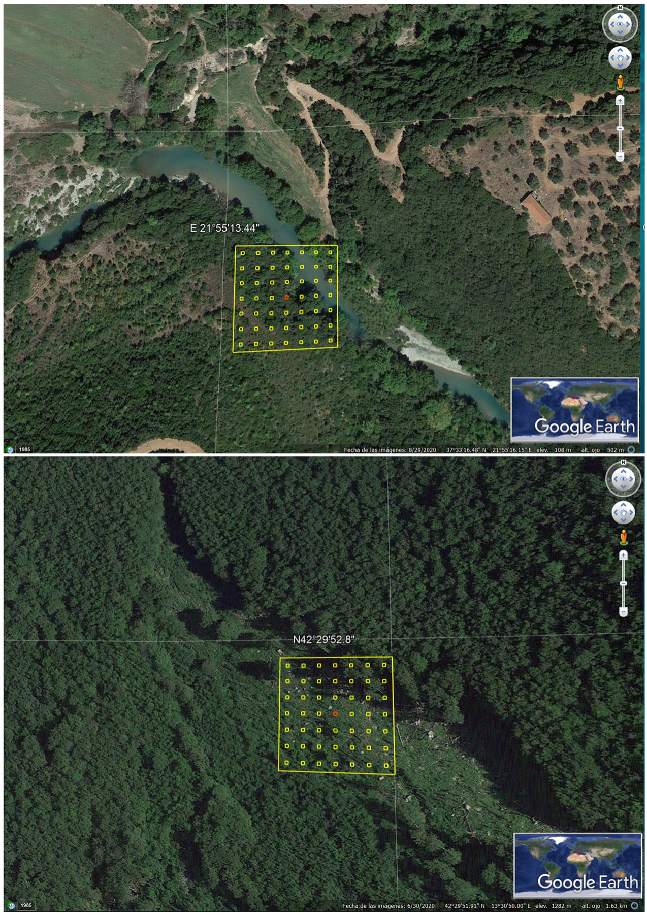
In the current study, a systematic survey was performed in the temperate FAO-ecozones in Europe within the GFS. The survey was designed by the Forest Assessment, Management and Conservation Division (FOM) of FAO and consisted of mapping vegetation and land-use classification schemes, consistent with the international guidelines set by the IPCC and FAO-FRA. A total of 11,159 sample plots of 0.5 ha (70 m × 70 m) (Figure 1) were assessed by means of a stratified systematic sampling design (systematic grill), in which sampling intensity was based on each longitude and latitude intersection (with a reduced intensity towards the north due to the curvature of the Earth). This sampling design was based on Bastin et al. [33]. The assessment therefore covered these 11,159 plots in the temperate FAO-ecozone in Europe, with each plot located in the same position in each cell in the grid. The grid of sampling plots is the same as used for the national forest assessments supported by FAO and by many national forest inventory programs. Rivas-Martínez et al. [41] have divided the European temperate macrobioclimate, which is equivalent to the temperate FAO-ecozone, into several bioclimatic zones that include temperate oceanic, temperate continental, and Mediterranean (Figure 2).

Figure 1.
Two examples of the 11,159 sample plots of 0.5 ha (70 m × 70 m), which were assessed by means of a stratified systematic sampling design (above image: Greek-plot; below image: Portuguese-plot).

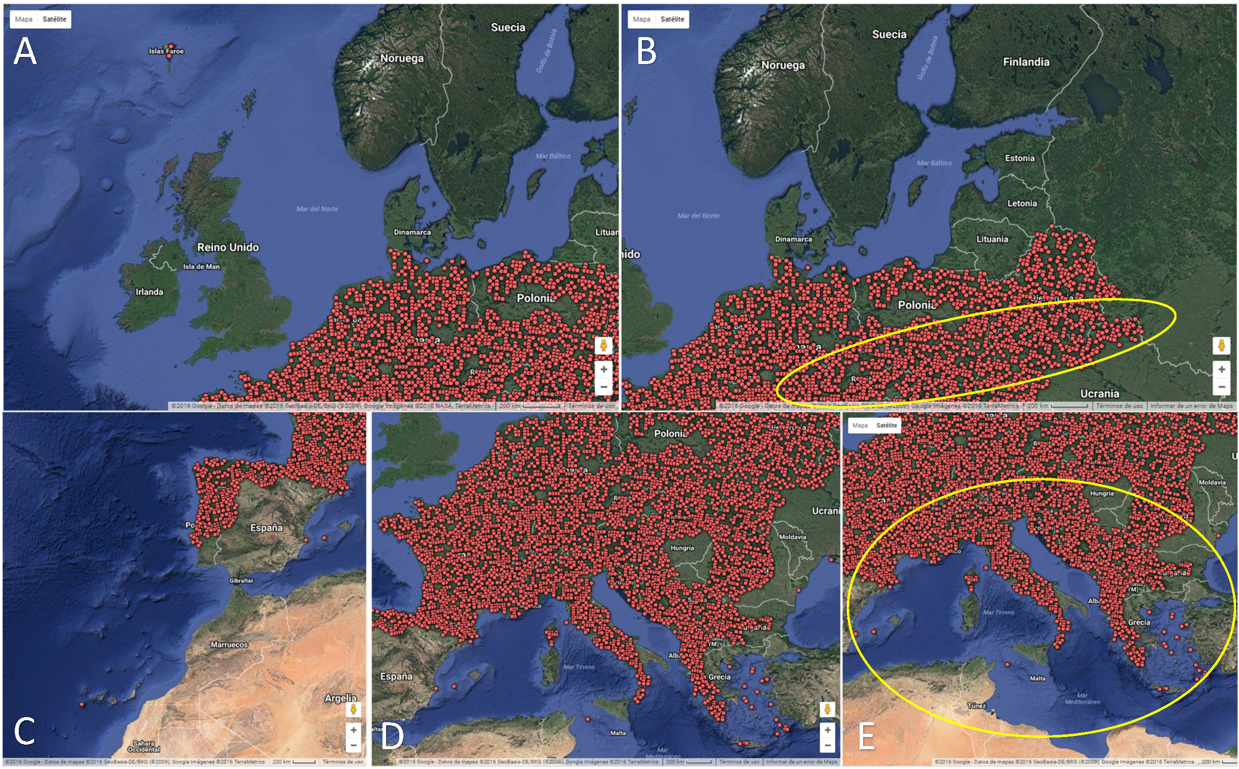
Figure 2.
Study area: temperate FAO-ecozones sampled in Europe using a systematic random sampling of plots (red points): (A,C) shows the studied temperate oceanic area; (B) shows the studied temperate continental area, located to the east of the image (yellow circle); (D) shows a complete representation of the temperate FAO-ecozones studied in Europe; (E) shows the studied temperate Mediterranean area, located to the south of the image (yellow circle). All figures are based on the global image of the Earth by Google Earth in July 2016 (Europe: 35° to 55° N—10° W to 35° E), accessed and managed through Collect Earth software [31,41].
The study area comprises over 2.90 Mkm2 between 38–54° north latitude and −8° to 28° west longitude (Figure 2). As part of the GFS sampling design, the inventoried area essentially covers the European temperate FAO-ecozone [42], with a prevalence of the temperate oceanic forest FAO-ecozone (45% of surface area). In total, 40% of the surface of the study area is under the temperate continental forest FAO-ecozone, an approximate 15% belongs to a temperate mountain system (7%) and the remaining area belongs to Mediterranean areas (equivalent to subtropical dry system FAO ecozone) [42]. According to FAO [42], the temperate domains, equivalent to Koppen–Trewartha climatic groups, are characterized by average temperatures above 10 °C in four to eight months of the year. Particularly, in temperate oceanic forest areas, average monthly temperature is always above 0 °C and annual rainfall may vary from 400 to 800 mm in the lowlands and up to 2000–3000 mm on windward lower coastal mountain slopes. In temperate continental forest areas, winters are colder, with at least one month having average temperatures below 0 °C. Rainfall generally decreases with distance from the ocean and also at higher latitudes. The temperate mountain system FAO ecozone includes areas over 800 m in altitude [42]. The majority of temperate forest soils fall into the Alfisols and Inceptisols US Soil Taxonomy groups. Lithic subgroups, i.e., shallow soils with hard rock near the surface, are also present to a significant extent [43].
The survey was implemented in Collect Earth [31] and conducted by 25 Master’s and PhD students, 5 professors of Forestry and Agricultural Engineering and Environmental Sciences and 1 technician from FAO, in July 2016 [36]. Collect Earth is an open-source software developed by FAO to enable the collection, management and analysis of georeferenced data using Google geospatial tools. Collect Earth allows free access and analysis of large remote sensing databases in a wide range of spatial and temporal resolutions, including DigitalGlobe, SPOT, Sentinel 2, Landsat and MODIS imagery within Google Earth, Bing Maps and Google Earth Engine. Collect Earth also provides graphic representations of inter-annual and intra-annual vegetation indices generated with Landsat and MODIS imagery in Google Earth Engine (GEE) [31]. All these features enable experts in land-use management to conduct robust land assessments by interpreting high-resolution (VHR) satellite imagery [44].
The abovementioned data sources were automatically geo-synchronized in each 0.5 ha plot to allow surveyors to record multiple (up to 70) parameters. The parameters used in this study were as follows: number of trees, IPCC land-use categories and land-use change by augmented visual interpretation. A plot size of 0.5 ha was chosen according to the FAO-FRA definition of forest [5], i.e., “Forests are lands of more than 0.5 hectares, with a tree canopy cover of more than 10 percent, which are not primarily under agricultural or urban land use, as well as areas in which tree cover is temporarily <10% but is expected to recover”.
Each plot was assigned to one of the six broad land-use categories recognized by the IPCC [35]: “cropland, forest land, grassland, settlement, wetland and other land”. The plots were classified in one land-use category according to a hierarchy rule, namely the land-use category with over a 20% threshold in the plot area. The hierarchy rule established the following order: (1) settlement; (2) cropland; (3) forest land; (4) grassland; (5) wetland; and (6) other land, following a conservational principle: the less conservational the land use, the higher the rank. Hence, settlement and cropland were ranked higher than forest land, as they indicate a substantial amount of human activity, but forest land was ranked higher than grassland because, when the 20% threshold of forest use is exceeded, this is inconsistent with another dominant non-forest activity [45]. Since 31 people carried out the survey, after this inventory, two FAO technicians closely supervised all inventory data to eliminate or correct all technical errors and inconsistencies produced by each member of the inventory team.
Martinez and Mollicone [45] have proposed a methodological approach based on remote sensing techniques to assess land use in accordance with the requirements of the United Nations Framework Climate Change Convention (UNFCCC) [33,45]. This methodology is based predominantly on recognizing key land elements and their function, as well as adopting the “predominant land use” criteria in the classification scheme established by the rules.
Plots were also assigned to one of five land-use categories defined by FAO-FRA (2000) [5]: forest, other wooded land, other land with tree cover, other land, and inland. Trees on land not classified in the FRA forest or other wooded land categories, and trees on farms, along roads and in many other locations not defined as forests in the country-level statistics, are considered as TOFs by FAO [5].
The land-use assessment was performed with 2015 VHR imagery. Land-use change was also evaluated following the same “predominant land use” criterion based on the imagery stored in the Google Earth platform from 2000 to 2014, as no images were available prior to 2000. The land-use change was obtained by comparing information for 2015 with the oldest information available between 2000 and 2014 that showed changes. Bastin et al. [33] provide a more detailed description of the described methodology.
The number of trees was registered in each plot, which was then classified according to the following five levels for the same years: (i) no trees; (ii) 1 to 10 trees; (iii) 11 to 20 trees; (iv) 21 to 30 trees; and (v) more than 30 trees. The percentage increase in the number of plots, CT, for 2000–2014 and 2015 compared to the initial value was calculated by:
where bT is the number of plots counted in 2015, and aT is the number of plots counted in the oldest images available between 2000 and 2014. The percentage increase in the number of plots in each land use, CL, between 2000–2014 and 2015 compared to the initial value was calculated by:
where bL is number of plots counted in 2015, and aL is the number of plots counted in the oldest images available between 2000 and 2014 for a specific land use. As the variables in this study express the frequency of qualitative variables, the sampling error was calculated according to the following expression [46]:
where zα/2 is the inverse standard normal cumulative distribution function for a confidence level of 1 − α, is the proportion of the number of plots with a specific characteristic, , is the proportion of plots without that characteristic, n is the size of the sample and f is the sampling intensity in terms of area sampled compared to total area. An χ2 test of independence was calculated to ascertain whether pij = pi ∗ pj (the joint probability for two events is the product of their probabilities) between the variables for “number of plots per land use category” and “number of plots per class of number of trees per plot” to obtain the relationship between land use and number of trees [47].
The sampling errors of each IPCC category were: 0.009, 0.009, 0.006, 0.005, and 0.002 for forest land, cropland, grassland, settlement, and wetland, respectively. All were statistically acceptable at less than 0.05. The independence relationship between “number of plots per land use category” and “number of plots per class of number of trees per plot” in these plots was obtained to determine whether land use influenced the number of trees in the study area. In the case of IPCC land uses, the p-value of the χ2 test of independence was less than 0.00001, so there was a statistically significant relationship between the number of plots for each land-use category and the number of trees contained in these plots.
Statgraphics Centurion V 18.1.13 software was used to obtain the statistical results. Data quality was controlled through a semi-automated data-cleansing procedure that automatically identified potentially inconsistent plots that were then manually reassessed by FAO members [33]. The data associated with the surveys of the 11,159 plots were analyzed with Saiku Server, modified ad hoc and integrated with the Collect Earth platform. Saiku Server is a web-based open-source software for data visualization and data querying.
3. Results
The inventory of plots from 2000 to 2015 in the temperate FAO-ecozones in Europe shows a slight change in land-use figures for the study area. In this period, the predominant IPCC land-use category in the temperate FAO-ecozones in Europe is forest land, which accounts for over 41% of the inventoried area. The retrospective analysis of GFS images from 2000 to 2015 in European temperate areas showed a slight upward trend for forest areas (Table 2).
Table 2.
Number of plots (and percentage) for the IPCC forest land category in GFS for the temperate FAO-ecozones in Europe.
Forest was the main FAO-FRA category in European temperate areas and accounted for 39% of plots. Forest plots had high canopy cover (83% of plots contained more than 30 trees) (Table 3). Conversely, other wooded land contained a prevalence of partial canopy cover (PCC) plots (75% of plots with under 30 trees), which is consistent with its definition. Other land with tree cover and other land also had a higher proportion of PPC plots (74% and 94% of plots with between 1 and 30 trees, respectively). Table 4 shows the results of the calculation of the number of trees per plot in the different IPCC land-use categories in the temperate FAO-ecozones in Europe in the survey process.
Table 3.
Number of plots per class of number of trees in different FRA land-use categories for temperate FAO-ecozones in Europe (2015).
Table 4.
Number of trees per plot in different IPCC land-use categories described by García-Montero [36,48] for temperate FAO-ecozones in Europe.
The forest IPCC land-use category contains a predominance of high tree density areas (80% of plots with more than 30 trees) (Table 4). These results suggest a moderate reforestation trend in areas with higher canopy cover (plots with 21 to 30 trees and more than 30 trees); the results also indicate a downward trend in plots with no trees (i.e., –17.5% plots from 2000 to 2015). In contrast, TOF areas associated with plots with fewer than 20 trees show a slight decline; thus, the 550 plots registered in 2000 fell to 439 in 2015. Regarding the number of trees per plot in the other IPCC land-use categories, García-Montero’s results [36,48] and Table 4 show that, in the cropland IPCC land-use category, there was a prevalence of plots with no trees (62% of plots). TOF areas (i.e., cropland plots with between 1 and 30 trees) comprised 30% of the plots. These results also show that TOF areas are declining in croplands, and this trend is accentuated in areas with higher tree density (Table 4). TOF areas (plots with 1 to 30 trees) are significantly abundant in grassland, with as much as 50% of the inventoried plots. TOF areas also account for 75% of plots in the settlements IPCC land-use category (Table 4). As in cropland, TOF areas in the grassland land use have followed a downward trend from 2000 to 2015, especially for higher tree densities (Table 4). The settlements IPCC land-use category exhibits the greatest differences in plots, and it is especially worth noting the increase in plots with no trees and TOF areas with plots containing 1 to 20 trees. In summary, TOFs in temperate FAO-ecozones in Europe in 2015 range from between 2424 plots (FRA classification) and 2462 plots (IPCC classification), accounting for over 22% of the inventoried area (Table 3 and Table 4). Finally, the average percentage of change in the number of plots between the two time periods for the different tree number classes reveals a sharp increase in the number of plots without trees in the temperate FAO-ecozones in Europe, as well as a decrease in the average number of plots in the group with more trees per plot in this region (Table 5).
Table 5.
Average increase (with standard deviation) in the number of plots per tree number class between 2000–2014 and 2015 in the temperate FAO-ecozones in Europe.
4. Discussion
The Forests category is the dominant land use in the GFS inventory of dryland in both Mediterranean areas [34] and temperate FAO-ecozones in Europe (Table 2). For an equivalent country list component, Barbati et al. [49] estimate that forests represent 31% of our study area.
Based on FRA data, Keenan et al. [50] reported a sustained increase of 3.7% in the area of European forests (excluding the Russian Federation) between 2000 and 2015. When the interval was expanded to the period from 2000 to 2020, this figure rose to 4.5% [51]. This expansion in forest area was also confirmed by Gold et al. [52] and is also consistent with the upward trend registered for the area of European forest by FAO-FRA (2020) [51] and Barbati et al. [49]. Our results for temperate FAO-ecozone forests in Europe were consistent with this trend, but in a less pronounced way from 2000 to 2015 (Table 2), which could be related to the downward trend in plots with no trees (Table 5).
Agricultural production in Europe has been intensified on currently available and suitable farmlands, and vast areas of farmland have been and are expected to be abandoned over the next 20 to 30 years. This change in use could be related to the increase in forest land use from 2000 to 2015 [53]. Our results have also highlighted a sharp increase in the number of plots without trees, and a decrease in the average number of plots in the group with more trees per plot in this region during this period (Table 4 and Table 5).
Trees Outside Forest areas in the temperate FAO-ecozone in Europe represent 14%, 30%, and 48% of plots for forest, cropland, and grassland IPCC land uses, respectively, and 75% for settlements (Table 4); however, in European Mediterranean dryland areas (Table 1), TOF areas correspond to between a half and one third of the number of plots for forest, cropland and grassland, and two thirds of the number of plots for settlements in comparison with the European temperate FAO-ecozone.
Trees Outside Forests could therefore play a more significant role in the sustainability of landscape management in the temperate FAO-ecozone in Europe (1–30 trees = 29% of the IPCC plots in 2015; Table 4) than in Mediterranean drylands (1–30 trees = 11% of the IPCC plots in 2015; Table 1). However, TOFs show a positive regional trend (+10.9%) in Mediterranean agricultural landscapes from 2000 to 2010 [50], while TOF areas in the temperate FAO-ecozone in Europe fell slightly between 2000 and 2015 (1–30 trees = 28% of the IPCC plots in 2000; Table 4); however, this pattern is not homogeneous throughout the study area, i.e., in Czech Republic, where Novotny et al. [28] described a 1.6% increase in TOFs between 1953 and 2014. However, only 12% of these TOFs have persisted in the same form during this period, and this persistence is linked primarily to riparian vegetation. The decreasing trend in TOF areas in the temperate FAO-ecozone in Europe showed different patterns depending on:
- (i)
- the different tree abundance per plot in the region (increase in TOF areas with 1 to 20 trees per plot and a decrease in TOF areas with 20 to 30 trees per plot; Table 5);
- (ii)
- the different IPCC land-use classes (Table 4):
- (a)
- Trees Outside Forest areas in forests with fewer than 20 trees per plot showed a slight decline versus TOF areas with 20–30 trees per plot, which increased by 2.6%;
- (b)
- Despite the abundance of TOFs in both grasslands and croplands in the temperate FAO-ecozone, these TOF areas decreased from 2000 to 2015;
- (c)
- In contrast, the abundance of TOFs in the settlements in this region increased during the same period.
Plots with no trees also show differences in both study areas. In dryland areas, most (80%) cropland and grassland plots do not contain any trees (Table 1), and this figure falls to 62% and 43%, respectively, in temperate FAO-ecozones in Europe (Table 4). The increase in the number of plots without trees in the temperate FAO-ecozone in Europe could be due to the sharp increase in settlement land use in the European area.
According to Marchetti et al. [4], we should expect to see the territorial expansion of TOFs in rural areas as a consequence of the EU’s Common Agricultural Policy and the increasing role of EFAs in farmlands. However, our results could indicate that the effect of EU policies is not yet evident on the ground. In this regard, Louichi et al. [39] noted the small effect of CAP greening on land use. However, these authors consider these measures as a first political step towards a more sustainable green economy. Plieninger et al. [7] remarked that the reason for the considerable increase (24.8% from 1964 to 2008) in farm trees in an intensive farming region (Eastern Germany) was a consequence of a combination of (a) successful greening policies (both regulatory and incentive-based), (b) growing environmental awareness, and (c) responses to negative environmental effects from extensive farm-tree removals.
Current forests and TOFs will have to cope with future climate conditions over at least several decades, perhaps even more than 100 years [54]. According to Lindner et al. [55], extreme events such as storms, droughts, flooding, and heat waves are probably the most important threats in temperate FAO-ecozones in Europe. Forests are particularly sensitive to climate change because the long life span of trees does not allow for rapid adaptation to environmental changes [54]. In the context of climate change, rising temperatures, changes in precipitation patterns, and longer drought periods are expected to significantly alter the distribution of TOFs [3].
However, forests play a key role in climate change mitigation. A decrease in total GHG emissions from LULUCF in the EU27 by 6.8%—ranging from 5.2% in 1990 to 8.1% in 2013—has been documented by the EU. The only current sink for GHG emissions in the EU-GHG inventory is forest land [56]. Specifically, TOFs are important for both the sequestration and the storage of carbon [17], and have thus become more relevant thanks to their important contribution to climate change mitigation, especially at the local level [3].
It will therefore be necessary to intensify the monitoring of forest lands and TOFs in temperate FAO-ecozones and other regions in Europe while taking into account the following: (i) the regional climate change projections of the Intergovernmental Panel on Climate Change until the end of the 21st century, and (ii) the different regional sensitivities of forests and TOFs to the impacts (both positive and negative) of climate change, as proposed by Lindner et al. [55] (e.g.,: “temperature increase will have a positive impact on forest growth in northern and western parts—less water-limited areas—and a negative impact on southern and eastern parts—water-limited—”) in temperate FAO-ecozones in Europe.
5. Conclusions
In summary, from 2000 to 2015, forest lands showed a moderate upward trend (0.2%), in agreement with other referenced works.
Trees Outside Forest areas in these temperate FAO-ecozones in Europe represent 30% and 48% of cropland and grassland IPCC land uses, respectively, and 75% of settlements. In previous GDA results for Mediterranean areas, TOF plots corresponded to 10–15% of plots for these land uses, respectively, and 50% of plots for settlements. Trees Outside Forests therefore play a more significant role in temperate areas in Europe than in Mediterranean drylands; however, between 2000 and 2015, the trend in temperate FAO-ecozones in Europe was slightly downward.
Plots with no trees also show differences in both study areas, i.e., in dryland areas, and most plots (80%) do not contain any trees in cropland and grassland. On the other hand, the increase observed in the number of plots without trees in the temperate FAO-ecozone in Europe could be due to the sharp increase in settlement land use in Europe.
Current forests and TOFs will face extreme events associated with climate change in temperate FAO-ecozones in Europe. However, both forests and TOFs play a significant role in climate change mitigation, as they provide the only current sink for GHG emissions in the EU.
In terms of current European land-use policies, although CAP greening may enhance the extension of TOFs, our results indicate that this effect may not yet be evident on the ground. Nevertheless, greening provides the first steps towards more sustainable land-use management within the framework of a green economy.
Author Contributions
Conceptualization: D.M., A.S.-P.D., C.P. (Chiara Patriarca), L.G.G.-M., C.P. (Cristina Pascual), F.G.-R.; Methodology: A.S.-P.D., C.P. (Chiara Patriarca), C.P. (Cristina Pascual), L.G.G.-M., D.M.; Software: A.S.-P.D., C.P. (Chiara Patriarca), D.M.; Data Acquisition and Curation: A.S.-P.D., C.P. (Chiara Patriarca), L.G.G.-M., C.P. (Cristina Pascual), F.G.-R., P.M.-O., C.C.-G.; Formal Analysis: C.P. (Cristina Pascual), L.G.G.-M., S.M.-F., P.M.-O., F.G.-R.; Writing—Original Draft Preparation: C.P. (Cristina Pascual), L.G.G.-M., S.M.-F., F.G.-R., P.M.-O.; Writing—Review and Editing: C.P. (Cristina Pascual), S.M.-F. and A.S.-P.D. All authors have read and agreed to the published version of the manuscript.
Funding
This research was funded by Federal Ministry for the Environment, Nature Conservation, Building and Nuclear Safety (BMUB), grant number GCP/GL0/553/GER (BMU) [36,48].
Institutional Review Board Statement
Not applicable.
Informed Consent Statement
Not applicable.
Data Availability Statement
Data supporting reported results can be found in: http://www.fao.org/in-action/global-forest-survey/background/en/. (accessed on 3 September 2021).
Conflicts of Interest
The authors declare no conflict of interest.
References
- Crowther, T.W.; Glick, H.B.; Covey, K.R.; Bettigole, C.; Maynard, D.S.; Thomas, S.M.; Smith, J.R.; Hintler, G.; Duguid, M.C.; Amatulli, G.; et al. Mapping Tree Density at a Global Scale. Nature 2015, 525, 201–205. [Google Scholar] [CrossRef] [PubMed]
- FAO. Global Forest Resources Assessment 2015. How Are the World’s Forest Changing? 2nd ed.; Food and Agriculture Organization of the United Nations: Rome, Italy, 2016; pp. 24–31. [Google Scholar]
- Salbitano, F.; Conigliaro, M.; Acil, N.; Borelli, S.; Cariñanos, P.; Castro, J.; Verlic, A.; Teobaldelli, M.; Krajter, S. Trees outside forests in the Mediterranean region. In State of Mediterranean Forests 2018; Food and Agriculture Organization of the United Nations: Rome, Italy; Plan Bleu: Marseille, France, 2018; pp. 51–71. [Google Scholar]
- Marchetti, M.; Garfì, V.; Pisani, C.; Franceschi, S.; Marcheselli, M.; Corona, P.; Puletti, N.; Vizzarri, M.; di Cristofaro, M.; Ottaviano, M.; et al. Inference on Forest Attributes and Ecological Diversity of Trees Outside Forest by a Two-Phase Inventory. Ann. For. Sci. 2018, 75, 37. [Google Scholar] [CrossRef] [Green Version]
- FAO. Global Forest Resources Assessment 2000: Main Report, 1st ed.; Food and Agriculture Organization of the United Nations: Rome, Italy, 2001; pp. 1–511. Available online: http://www.fao.org/3/Y1997E/Y1997E00.htm (accessed on 3 September 2021).
- Chakravarty, S.; Pala, N.A.; Tamang, B.; Sarkar, B.C.; Manohar, A.K.; Rai, P.; Puri, A.; Shukla, G. Ecosystem Services of Trees Outside Forest. In Sustainable Agriculture, Forest and Environmental Management 2019; Jhariya, M., Banerjee, A., Meena, R., Yadav, D., Eds.; Springer: Singapore, 2019; pp. 228–234. [Google Scholar]
- Plieninger, T.; Schleyer, C.; Mantel, M.; Hostert, P. Is There a Forest Transition Outside Forests? Trajectories of Farm Trees and Effects on Ecosystem Services in an Agricultural Landscape in Eastern Germany. Land Use Policy 2012, 29, 233–243. [Google Scholar] [CrossRef] [Green Version]
- Bolyn, C.; Lejeune, P.; Michez, A.; Latte, N. Automated Classification of Trees Outside Forest for Supporting Operational Management in Rural Landscapes. Remote Sens. 2019, 11, 1146. [Google Scholar] [CrossRef] [Green Version]
- Ryszkowski, L.; Kędziora, A. Modification of water flows and Nitrogen fluxes by shelterbelts. Ecol. Eng. 2007, 29, 388–400. [Google Scholar] [CrossRef]
- Lee, K.H.; Ehsani, R.; Castle, W.S. A Laser Scanning System for Estimating Wind Velocity Reduction through Tree Windbreaks. Comput. Electron. Agric. 2010, 73, 1–6. [Google Scholar] [CrossRef]
- Chen, B.; Wang, Y.-C. Carbon Storage in Old-Growth Homestead Windbreaks of Small Islands in Okinawa: Toward the Sustainable Management and Conservation. Forests 2020, 11, 448. [Google Scholar] [CrossRef]
- Vos, P.E.J.; Maiheu, B.; Vankerkom, J.; Janssen, S. Improving local air quality in cities: To tree or not to tree? Environ. Pollut. 2013, 183, 113–122. [Google Scholar] [CrossRef]
- Bottalico, F.; Travaglini, D.; Chirici, G.; Garfì, V.; Giannetti, F.; De Marco, A.; Fares, S.; Marchetti, M.; Nocentini, S.; Paoletti, E.; et al. A spatially-explicit method to assess the dry deposition of air pollution by urban forests in the City of Florence, Italy. Urban For. Urban Green. 2017, 27, 221–234. [Google Scholar] [CrossRef]
- Schnell, S.; Kleinn, C.; Ståhl, G. Monitoring Trees Outside Forests: A Review. Environ. Monit. Assess. 2015, 187, 600. [Google Scholar] [CrossRef] [PubMed]
- Seidel, D.; Busch, G.; Krause, B.; Bade, C.; Fessel, C.; Kleinn, C. Quantification of Biomass Production Potentials from Trees Outside Forests—A Case Study from Central Germany. BioEnergy Res. 2015, 8, 1344–1351. [Google Scholar] [CrossRef]
- Maack, J.; Lingenfelder, M.; Eilers, C.; Smaltschinski, T.; Weinacker, H.; Jaeger, D.; Koch, B. Estimating the Spatial Distribution, Extent and Potential Lignocellulosic Biomass Supply of Trees Outside Forests in Baden-Wuerttemberg Using Airborne LiDAR and OpenStreetMap Data. Int. J. Appl. Earth Obs. Geoinform. 2017, 58, 118–125. [Google Scholar] [CrossRef]
- Plieninger, T. Capitalizing on the Carbon Sequestration Potential of Agroforestry in Germany’s Agricultural Landscapes: Realigning the Climate Change Mitigation and Landscape Conservation Agendas. Landsc. Res. 2011, 36, 435–454. [Google Scholar] [CrossRef]
- Price, B.; Gomez, A.; Mathys, L.; Gardi, O.; Schellenberger, A.; Ginzler, C.; Thürig, E. Tree Biomass in the Swiss Landscape: Nationwide Modelling for Improved Accounting for Forest and Non-Forest Trees. Environ. Monit. Assess. 2017, 189, 106. [Google Scholar] [CrossRef] [Green Version]
- de Foresta, H.; Somarriba, E.; Temu, A.; Boulanger, D.; Feuily, H.; Gauthier, M. Towards the Assessment of Trees Outside Forests; FAO: Rome, Italy, 2013. [Google Scholar]
- Zomer, R.J.; Trabucco, A.; Coe, R.; Place, F. Trees on Farm: Analysis of Global Extent and Geographical Patterns of Agroforestry; ICRAF Working Paper; ICRAF: Nairobi, Kenya, 2009. [Google Scholar]
- Malkoç, E.; Rüetschi, M.; Ginzler, C.; Waser, L.T. Countrywide mapping of trees outside forests based on remote sensing data in Switzerland. Int. J. Appl. Earth Obs. Geoinform. 2021, 100, 102336. [Google Scholar] [CrossRef]
- Fridman, J.; Holm, S.; Nilsson, M.; Nilsson, P.; Ringvall, A.; Ståhl, G. Adapting National Forest Inventories to Changing Requirements—the Case of the Swedish National Forest Inventory at the Turn of the 20th Century. Silva Fenn. 2014, 48, 1–29. [Google Scholar] [CrossRef] [Green Version]
- Tewari, V.P.; Sukumar, R.; Kumar, R.; Gadow, K.v. Forest Observational Studies in India: Past Developments and Considerations for the Future. For. Ecol. Manag. 2014, 316, 32–46. [Google Scholar] [CrossRef]
- Kleinn, C. On large-area inventory and assessment of trees outside forests. Unasylva 2000, 51, 3–10. [Google Scholar]
- Meneguzzo, D.M.; Liknes, G.C.; Nelson, M.D. Mapping Trees Outside Forests Using High-Resolution Aerial Imagery: A Comparison of Pixel- and Object-Based Classification Approaches. Environ. Monit. Assess. 2013, 185, 6261–6275. [Google Scholar] [CrossRef]
- Herrera-Fernández, B. Classification and Modeling of Trees Outside Forest in Central American Landscapes by Combining Remotely Sensed Data and GIS. Ph.D. Thesis, Universität Freiburg, Freiburg, Germany, 2003. [Google Scholar]
- Plieninger, T. Monitoring directions and rates of change in trees outside forests through multitemporal analysis of map sequences. Appl. Geogr. 2021, 32, 566–576. [Google Scholar] [CrossRef] [Green Version]
- Novotný, M.; Skalos, J.; Plieninger, T. Spatial-temporal changes in trees outside forests: Case study from the Czech Republic 1953–2014. Appl. Geogr. 2017, 87, 139–148. [Google Scholar] [CrossRef]
- Filippelli, S.K.; Vogeler, J.C.; Falkowski, M.J.; Meneguzzo, D.M. Monitoring conifer cover: Leaf-off lidar and image-based tracking of eastern redcedar encroachment in central Nebraska. Remote Sens. Environ. 2020, 248, 111961. [Google Scholar] [CrossRef]
- Graves, J.A.; Caughlin, T.T.; Asnerd, G.P.; Bohlmana, S.A. A tree-based approach to biomass estimation from remote sensing data in a tropical agricultural landscape. Remote Sens. Environ. 2018, 218, 32–43. [Google Scholar] [CrossRef]
- Bey, A.; Sanchez-Paus Diaz, A.; Maniatis, D.; Marchi, G.; Mollicone, D.; Ricci, S.; Bastin, J.B.; Moore, R.; Federici, S.; Rezende, M.; et al. Collect Earth: Land Use and Land Cover Assessment through Augmented Visual Interpretation. Remote Sens. 2016, 8, 807. [Google Scholar] [CrossRef] [Green Version]
- FAO. Global Forest Survey. Available online: http://www.fao.org/in-action/global-forest-survey/en/ (accessed on 3 September 2021).
- Bastin, J.F.; Berrahmouni, N.; Grainger, A.; Maniatis, D.; Mollicone, D.; Moore, R.; Patriarca, C.; Picard, N.; Sparrow, B.; Abraham, E.M.; et al. The Extent of Forest in Dryland Biomes. Science 2017, 356, 635. [Google Scholar] [CrossRef] [PubMed] [Green Version]
- Martin-Ortega, P.; Picard, N.; García-Montero, L.G.; del Río, S.; Penas, A.; Marchetti, M.; Lasserre, B.; Ozdemir, E.; García-Robredo, F.; Pascual, C.; et al. Importance of Mediterranean Forests. In State of Mediterranean Forests 2018, 1st ed.; Food and Agriculture Organization of the United Nations: Rome, Italy; Plan Bleu: Marseille, France, 2018; pp. 31–50. [Google Scholar]
- IPCC. Good Practice Guidance for Land Use, Land-Use Change and Forestry; Institute for Global Environmental Strategies: Hayama, Japan, 2003; 590p. [Google Scholar]
- García-Montero, L.G. Project “Collecting Data Through Collect Earth Tools on Southern Europe Dryland Zones in the Context of Global Forest Survey Project (GFS)”. In The Framework of the FAO Project GCP/GL0/553/GER (BMU) Global Forest Survey (GFS); Universidad Politécnica de Madrid: Madrid, Spain, 2015; Available online: http://www.fao.org/in-action/global-forest-survey/partners/universities/es/ (accessed on 3 September 2021).
- Abadie, J.; Dupouey, J.-L.; Avon, C.; Rochel, X.; Tatoni, T.; Bergès, L. Forest Recovery since1860 in a Mediterranean Region: Drivers and Implications for Land Use and Land Cover Spatial Distribution. Landsc. Ecol. 2018, 33, 289–305. [Google Scholar] [CrossRef]
- European Commision. Report from the Commission to the European Parliament and the Council on the Implementation of the Ecological Focus Area Obligation under the Green Direct Payment Scheme; COM/2017/0152 Final; EC: Brussels, Belgium, 2017.
- Louhichi, K.; Ciaian, P.; Espinosa, M.; Perni, A.; Gomez y Paloma, S. Economic impacts of CAP Greening: Application of an EU-wide individual farm model for CAP analysis (IFM-CAP). Eur. Rev. Agric. Econ. 2018, 45, 205–238. [Google Scholar] [CrossRef]
- Van Lierop, P.; Lindquist, E.; Sathyapala, S.; Franceschini, G. Global Forest Area Disturbance from Fire, Insect Pests, Diseases and Severe Weather Events. For. Ecol. Manag. 2015, 352, 78–88. [Google Scholar] [CrossRef] [Green Version]
- Rivas-Martínez, S.; Peñas, A.; Díaz, T.E. Worldwide Bioclimatic Classification System. Glob. Geobot. 2011, 1, 1–634. [Google Scholar]
- FAO. Global Ecological Zones for FAO Forest Reporting: 2010 Update; FAO: Rome, Italy, 2010. [Google Scholar]
- Adams, M.B.; Kelly, C.; Kabrick, J.; Schuler, J. Temperate Forest and Soils. In Global Change and Forest Soils; Busse, M., Giardina, C.P., Morris, D.M., Page-Dumroese, D.S., Eds.; Elsevier: Amsterdam, The Netherlands, 2019; pp. 3–510. [Google Scholar]
- Saah, D.; Johnson, G.; Ashmall, B.; Tondapu, G.; Tenneson, K.; Patterson, M.; Poortinga, A.; Markert, K.; Quyen, N.H.; San Aung, K.; et al. Collect Earth: An Online Tool for Systematic Reference Data Collection in Land Cover and Use Applications. Environ. Modell. Softw. 2019, 118, 166–171. [Google Scholar] [CrossRef]
- Martínez, S.; Mollicone, D. From Land Cover to Land Use: A Methodology to Assess Land Use from Remote Sensing Data. Remote Sens. 2012, 4, 1024–1045. [Google Scholar] [CrossRef] [Green Version]
- Cochran, W.G. Sampling Techniques, 3rd ed.; John Wiley and Sons: New York, NY, USA, 1991; pp. 1–448. [Google Scholar]
- Pearson, E.S.; Neyman, J. On the Problem of Two Samples. In Joint Statistical Papers; Neyman, J., Pearson, E.S., Eds.; Cambridge University Press: Cambridge, UK, 1967; pp. 99–115. [Google Scholar]
- García-Montero, L.G. Project Collecting Data through Collect Earth Tools in Europe and North America Zones in the Context of the Pilot on Global Assessment on Trends in Tree Cover/Land Use in the Framework of the World Forest Open Date Initiative (GCP/GL0/553/GER (BMU) Global Forest Survey GFS); Universidad Politécnica de Madrid: Madrid, Spain, 2016; Available online: http://www.fao.org/in-action/global-forest-survey/partners/es/ (accessed on 3 September 2021).
- Barbati, A.; Corona, P.; Marchetti, M. Annex 1: Pilot Application of the European Forest Types. In State of Europe’s Forests 2011. Status and Trends in Sustainable Forest Management in Europe; Michalak, R., Ed.; FOREST EUROPE, UNECE and FAO: Oslo, Norway, 2011; pp. 259–273. Available online: https://unece.org/fileadmin/DAM/publications/timber/Forest_Europe_report_2011_web.pdf (accessed on 3 September 2021).
- Keenan, R.J.; Reams, G.A.; Achard, F.; de Freitas, J.V.; Grainger, A.; Lindquist, E. Dynamics of Global Forest Area: Results from the FAO Global Forest Resources Assessment 2015. For. Ecol. Manag. 2015, 352, 9–20. [Google Scholar] [CrossRef]
- FAO. Global Forest Resources Assessment 2020: Main Report, 1st ed.; Food and Agriculture Organization of the United Nations: Rome, Italy, 2020; pp. 1–186. [Google Scholar]
- Gold, S.; Korotkov, A.; Sasse, V. The Development of European Forest Resources, 1950 to 2000. For. Policy Econ. 2006, 8, 183–192. [Google Scholar] [CrossRef]
- Hersperger, A.M.; Oliveira, E.; Pagliarin, S.; Palka, G.; Verburg, P.; Bolliger, J.; Grădinaru, S. Urban Land-Use Change: The Role of Strategic Spatial Planning. Glob. Environ. Chang. 2018, 51, 32–42. [Google Scholar] [CrossRef]
- EC European Commision. Impacts of Climate Change on European Forests and Options for Adaptation. 2008. Available online: https://www.researchgate.net/publication/285320195_ (accessed on 3 September 2021).
- Lindner, M.; Maroschek, M.; Netherer, S.; Kremer, A.; Barbati, A.; Garcia-Gonzalo, J.; Seidl, R.; Delzon, S.; Corona, P.; Kolström, M.; et al. Climate change impacts, adaptive capacity, and vulnerability of European forest ecosystems. For. Ecol. Manag. 2010, 259, 698–709. [Google Scholar] [CrossRef]
- Eurostate. Climate Change—Driving Forces. 2021. Available online: https://ec.europa.eu/eurostat/statistics-explained/index.php?title=Climate_change_-_driving_forces#Land_use.2C_land_use_change_and_forestry_is_an_overall_sink_of_emissions (accessed on 3 September 2021).
Publisher’s Note: MDPI stays neutral with regard to jurisdictional claims in published maps and institutional affiliations. |
© 2021 by the authors. Licensee MDPI, Basel, Switzerland. This article is an open access article distributed under the terms and conditions of the Creative Commons Attribution (CC BY) license (https://creativecommons.org/licenses/by/4.0/).