1. Contextualization and Study-Guiding Questions
Cities are made of built volumes connected by spaces and networks, and their main function is to support the economic, social, cultural, and environmental processes [
1], as a kind of association of individuals and places, not only defining the physical form, but also the content. More than ever, the city is the space of flows as well: the infrastructure and the possibility of shifting property, individuals and information translated by the concepts of accessibility and mobility, determining factors for the exercise and reproduction of the urban space [
2]. Therefore, accessibility and mobility conditions become decisive in the dynamics of spatial organization, turning out to be the main object for increased efficiency, urban resilience, and environmental sustainability. For [
3], the space production process manifests itself by the formation of a city characterized by the connection of different places in a same network of simultaneous interaction that gathers processes, property/goods, and people.
The shifting networks of persons and goods (mobility systems) are produced in the urban space, where use and appropriation forms [
4] are produced. So, it is necessary to investigate how the spatial organization dynamics of the economic activities, as well as the action of given central spaces, may be associated to the spatial distribution of the population flows. This is a necessary analysis, not only for the setting of public transport policies, but also for the proposition of actions, and is potentially useful to the urban and regional management and planning in a broader way, including the possible environmental impacts.
In Brazil, especially in the big urban and metropolitan centers, the propositions of creation/induction of centralities have deserved increased attention in the public policies of territory planning and have been incorporated in land-use planning that have become mandatory after the enactment of the Federal Constitution of 1988 for cities with over 20,000 inhabitants, and that shall be approved by their city councils. The Ministry of the Cities [
5] itself recommends this instrument to further the logic of multicentrality in the urban densification as a way to promote a better distribution of the activities in the territory, reducing the medium and long-distance flows. The Municipality of Belo Horizonte, the Capital city of the State of Minas Gerais, Brazil, according to the last Demographic Census data that took place in 2010, had a resident population of nearly 2.5 M, spread over an area of only 330 square kilometers. This high demographic density, exemplary of a great part of the Brazilian capitals, often goes side by side with the reproduction of innumerable precarious conditions when it comes to the provision of urban accessibility and mobility, due to the different levels of access to land, causing the socio-spatial peripheralization and worsening social vulnerability, besides the environmental degradation itself.
More specifically, the municipality spatial accessibility and mobility conditions are characterized by a series of iniquities arising from the structuring of a circulation space in which the individual transport was historically privileged [
6]. In spite of the decreasing data as compared to the Origin and Destination (OD) Survey of 2002 and 2012 [
7], the transport system is still highly centered in the bus system nowadays (corresponding to 98% of the collective transport rides in 2012), strongly tending to radius-centered and diametrical shapes, which increases the probability of retentions and traffic jams around the central and pericentral areas.
Supposing that urban motorized mobility is characterized as a public service to supply the spatial displacement of great population volumes, as in the case of Belo Horizonte, whatever the reason, either for manpower displacement or to meet commerce and services consumer market in the urban space, it may be an indicator sensitive to the socio-spatial dynamics, and to the regional economic organization dynamics especially when it comes to the centralization level and to the power of attraction of the Central Area. Likewise, the concentration of given economic activities itself, notably that of commerce and services, plays a role in the ride demand attraction, boosting the action of centripetal forces and of radius-centric circulation models, and consequently, a cycle of concentration.
In the case of Belo Horizonte, some issues are central driving forces for the present work: has there been an increased level of concentration of rides to the municipal Central Area recently? Has the policy of decentralization, expressly encouraged in one of the objectives of the present Master Plan of Belo Horizonte, set forth by Act No. 7.165 [
8], revoked by Act No. 11.181 [
9], been manifesting itself in the analyzed decade? Have new centralities taken root in the urban space of the Capital attracted expressive travel flows? Is there any flow (re)arrangement in the intraregional scale, which involves the metropolitan municipalities around Belo Horizonte? Making use of the last two OD Surveys (2002 and 2012) in an effort to give an answer to these questions, the present work aims to evaluate the likely decrease of the Belo Horizonte Central Area power of attraction as a result of the induction process of the power of attraction of new urban centralities, identified by travel flows. The policy proposed in the Master Plan of Belo Horizonte had the objective of reducing distances and travel times. Though the methodology presented allows synthesis by means of specific indicators and specific aspects about the relation among the municipal motorized flows. This information is potentially useful to decision-making and to the promotion of integrated urban and territorial management and planning based on the principles of equitable, efficient, and sustainable land use, allowing the formulation of policies of mobility and public transport systems management on behalf of an urban sustainability in its broader sense.
2. Mobility, Center and Urban Centralities
Urbanization is one the outstanding processes in contemporaneity, presenting unique characteristics in the urban and metropolitan centers of the peripheral countries. According to the United Nations report, in 2014, approximately 54% of the world population lived in urban areas (when the so-called world urban majority milestone was placed). If in 1950 about 30% of the world population resided in the urban space, UNO’s own projections indicate that this proportion would reach 66% in 2050 [
10]. As described by [
11], the post-industrialization city represents the mediation of the relations between the global processes (economic, social, political and cultural) and the local rhythms that alter the urban space and essentially collaborate in the consolidation of the dense and articulated urban networks along the territory [
12]. In many aspects, the obstacles to urban mobility are strengthened by the escalated urbanization process [
13,
14], direct reflexes of the speedy expansion process and urban tissue growth, arising from the high spatial concentration of population and of mobility demands in specific areas, notably in the central area [
6,
15,
16,
17]. According to [
18], the dynamics and measures encompassing space play an important part in the approach to mobility and adversity reduction issues, as, for example, energy consumption.
The Center for Energy Conservation of the Netherlands, in a study carried out for the city of Utrecht, concluded that territorial planning may cause a 17% decrease in traffic, producing an evident positive effect on the environment [
15]. Similar research was conducted by [
16,
17] in other European cities and was compared to cities in the United States and Australia. Thus, there is an interdependence between urban growth and demand and offer of transport, so that transport deficiencies directly interfere in the daily life of the population, requiring several forms of public authorities’ intervention. According to [
19], the Sustainable Urban Mobility Plan (SUMP) became a strategic tool to local human development. Moreover, it is considered a guide to promote changes and contribute with more efficient, safe, and sustainable solutions. In this sense, the diversity of land use, the densification, and pedestrian-friendly development have stressed the agenda of the new urbanism [
20,
21] as a mechanism for discussions involving the practices of sustainable urban mobility and their many benefits [
21,
22]. According to [
23], though the concept of sustainability has become part of a political discourse [
24], the sustainable urban mobility is still an unresolved question, no more than an unaccomplished promise.
The relation between urban structure and transport is studied by [
21] and summarized by [
25], who considers it “(...) difficult to get to know urban transports without a previous study of the urban structure on which they will be developed”. The relations between transport and the space produced may be studied in different scales. The large infrastructures participate in the (re)organization of the urban networks and in the national and international land balance scales. As for the regional scale, the investigations of the impact of these infrastructures on land may cope with the questions related to the analysis of offer and service level, as well as with public administration. On the other hand, the local study allows the analysis of the relation of infrastructure with production and transformation of the urban space [
26]. Thus, the concepts of mobility and their relation to the urban form/structure become central to the comprehension of the dynamics and heterogeneity of the spatial organization.
Taking population displacements as a proxy for the dynamics and spatial interaction, [
27] identifies some elements defined as essential to the urban spatial structure: the hubs, defined as areas connecting the spaces through which the urban stocks are transferred, acting within the urban structure as spatial bridges among the different districts; the center, defined by the authors as the most relevant area where the urban stocks are accumulated; the centralities, referring to the socio-economic boundaries generated by localizations determined by the concentration of rides. According to [
28], the main defining characteristics of the urban centralities relate to symbolism, accessibility, the relations, concentration of activities, and to land value. According to [
29], the formation process of centralities must be analyzed from a historical perspective of the localization of the commercial and services activities, also characterized as a dynamic process arising from several factors such as: change of roles of each city, economic and demographic growth, expansion of the urban tissue, installation of new infrastructures of circulation and transport, real estate market, public and private investments, and dynamics of socio-spatial distinction of distribution of land use for residential, commercial, and service purposes. The authors in [
30] also list the progress of information processing and telecommunications. The author in [
31] believes that the morphological transformation of the urban organization is induced by the facility of displacements and for their difficulty, being a dynamic process in continued transition, where obsolete spaces are replaced by new ones.
There is a strong relation among economic system, urban and mobility policies, and produced spaces. The authors in [
32] (p. 4) add that “improved mobility and quality of life are inextricably linked”. Other studies such as [
33,
34,
35,
36] assess and relate the lack of offer and access to the urban transport system to social exclusion. Thus, the urban transport system takes central importance to the production of the urban space once urban mobility may enable the access to the collective consumption means in a more equitable way. The public transport systems take on this role of interconnection between production and consumption of/in the space. In Brazil, the main cities confer to buses, the main modal matrix of mobility. In a certain way, this transport system increases the outskirts’ dependence on the urban center, the itineraries of which are established with the duration of a pendular propensity, strongly tending to centralization. The question posed is if this riding behavior is in fact the real “wish” of populational displacements, considering the cities’ offer concerning transport systems.
Several works on the role of the urban centers, their plurality, and importance have been published. Either as elements (centers and subcenters) or as urban form/structure altering processes (centralization and decentralization), the urban space is a “pure form: the meeting point, the place for reunions, simultaneity” [
37] (p. 110). While centers are larger opportunity concentrating areas, they will be mainly characterized for their quality of attracting rides for several purposes (i.e., work, shopping, services, education, and leisure). Therefore, relating urban mobility to the dynamics of the spatial organization becomes relevant, especially in what concerns the power of attraction of the Central Area and inasmuch as mobility may be useful in the identification of the traditional Central Business District (CBD).
According to [
38], the comprehension of the urban structure, of the spatial arrangement of hubs, of the centers and centralities (or subcenters), and the way individuals interact with these structures is of paramount importance. According to [
39], the dominant model of an industrial city is based on a monocentric structure. On the other hand, other authors consider that this structure does not represent the contemporary urban structure anymore [
28]. To [
40], the contemporary cities, due to their greater complexity, show polycentrality patterns requiring specific study for their comprehension. The metropolitan regions have increasingly become more decentralized, and the traditional CBDs turned out to present a much lower share of employment, services, and commercial opportunities than before [
41]. Ref. [
42] (p. 9) adds that “No city is ever 100% monocentric, and it is seldom 100% polycentric (...). Some cities are dominantly monocentric, others are dominantly polycentric, and many are in between”. Proportionally to their growth, the original monocentric structure may evolve and spread itself throughout the urban tissue heading to the polycentric structure. To this same author, the mono and polycentric structures stem from the same origin but are observed in different moments of their evolutionary process [
36].
To [
37], the city is made by the group of necessary centers to supply the demands of the economic activities and population. The difference between the centers causes the forms of interdependence, resulting in the shift from the notion of center to the notion of center network. The author of [
43] asserts that the new circulation of flows, altering the influence of the “old” center, deconstructs the hierarchical logic of the traditional city that depends on the existence of a steady and permanent center. The author of [
44] complements the ideas of [
37] and [
42], while defining the capitalist city as the stage of a series of social processes, among them capital accumulation and social reproduction, considers that the elements that enable, along time, the creation of spatial functions and forms are not mutually exclusive, and may occur simultaneously in the same city. The author of [
45] also emphasizes the notion that every human spatial agglomeration develops a main center. On this topic, [
46] states that the idea of city is linked to the idea of concentration, and refers to [
37] to support his definition. The term “concentration” carries in itself the definition of center. The cities themselves are centers for they are fundamentally points of convergence. Nevertheless, the density of occupation is not uniform; having points of convergence and concentration will always belong to this occupation, regardless of the analyzed scale [
46]. Ref. [
45] does not turn down the concept of “polynucleate” cities introduced by [
47], but defends that, in spite of in some agglomerations the spatial growth does not take place from a sole hegemonic center: “there is one and only one, that is the main center”, where there is a greater amount of opportunities, and the subcenters, defined by the author as “diversified and balanced agglomerations of commerce and services, other than the main center” [
45] (p. 293). Furthermore, according to this author, the subcenters comply with the same access requirements as the main centers. The former complies with the requirements to a part of the city only, the main center encompasses the whole city.
Much research in the area has been published, including the works by [
48] and [
49]. A growing number of networks and flows in the cities have been analyzed with the assistance of persons and goods circulation data and spatial analysis. Many new methods are being applied to new problems. For instance, the localization patterns of the commercial activities are constantly used in the studies of urban spatial structure [
50,
51,
52]. Recently, the movement patterns of individuals have been used in these studies [
50]. The identification of the urban spatial structure based on the population’s displacement data and application of spatial statistics is central to the evaluation of social, economic, and environmental impacts caused by the patterns of activities and rides [
27]. Moreover, this comprehension has become an important tool for urban planning and mobility and accessibility management, in the light of the structure of the use of space in the cities [
53].
In Brazil, the identification of centralities has been increasingly noticed in the management and planning of land and urban mobility and has been legally incorporated in the municipal master plans [
Land-use Planning]. It is also recommended that this instrument furthers the logic of multicentrality and urban densification in order to favor a better distribution of the activities in the territory, reducing the distances between places of residence and opportunities, now located in closer centers, and lower the number of motorized rides [
5]. The heterogeneity and the nature of centralities may result, for example, in the city space dispersion and in lower attraction, besides the occurrence of problems in providing transport infrastructure, hampering the access of populations residing in centers even less expressive, producing what [
54] calls negative polycentrality, in which the number of individual motorized displacements tends to increase [
55]. In these cases, the infrastructure of collective transport and the incentive to the non-motorized options do not go side by side with the new centralities [
56].
As in other Brazilian cities, Belo Horizonte and region reproduce fragilities in the provision of urban mobility, a historical consequence of serial failures of the public authorities in intervening in the excluding urbanization process and of the vicious cycles found in the social inclusion processes and in the socioeconomic development [
6]. This scenery displays a distribution of spatial mobility repeatedly characterized by the spread of iniquities, giving rise to a circulation space structuring that, despite maintaining privileges to the individual transport (automobiles), the more vulnerable groups (pedestrians, bicycle riders and users of the collective public transport) have been shunned and have had their wishes for intraurban circulation overlooked. Moreover, the automobile means of transport increment leads to lower efficiency levels of collective transportation, mostly in the central and pericentral areas of the Capital city of Minas Gerais. The great flow of vehicles in these areas compromises the road flowability in the main circulation courses of goods and persons caused by the strong commercial and services attraction of the city’s Hypercenter [
7]. With this background, the management and planning process have assumed a central function in the search for a supposed rational decision-making related to the transport and traffic systems. The Land-Use Planning of Belo Horizonte, provided for in Act 7.165 [
8], revoked by Act 11.181 as of 2019 [
9] sets forth as a strategic objective the prioritization of the collective transport system and the guidance of urban development towards polycentrism, in an effort to minimize the intense traffic concentration in the municipality. The guidelines provided for its Art.4, among others, set forth: the promotion of urban spatial strategies, the conduction of the territorial planning by providing accessible and well-connected infrastructures and services, designing a compact urban tissue and providing its integration to new centralities, furthering conformation and consolidation of centrality areas, developing a sustainable and efficient transport infrastructure, and, finally, qualifying the modes of collective transport.
As compared to the international literature, [
28] state that, in the case of Brazil, investments in research are still incipient. The efforts made in this article are exactly meant to help overcome this gap. Another issue that some researchers came up with, and specifically explored in this work, is the possibility of evaluating the power of attraction of the rides to CBD, given a preset regional urban cut. Thus, based on the use of secondary data and spatial analysis tools, the investigation on to what extent mobility, herein represented by the number of motorized flows in Belo Horizonte, identified in the last two surveys origin and destination, allows the evaluation of attraction of rides taking place in the Central Area (CBD), as well as the flow growth for new centralities in the municipality, is pursued. As demonstrated by [
57], CBD has already been specially treated by the Original Plan, presenting the major concentration of services and commercial activities, and the best endowment for infrastructure. Nowadays, it seems that the situation has not changed. According to the OD data in 2012, the access to goods and services in the Central Area is generally responsible for 31.4% of displacements, also suggesting a dependence relation between CBD and further spatial units of the Capital city. Although additional care should be invested in the interpretation of the results, and considering the limits of the temporal cuts and database used, besides the specific characteristics of Belo Horizonte as well, the empirical evidence translated by the indicators proposed in this work may induce a more accurate pondering on the recent configuration of the centers and centralities in the urban space, with the preset connections by means of spatial mobility of the population.
3. Materials and Methods
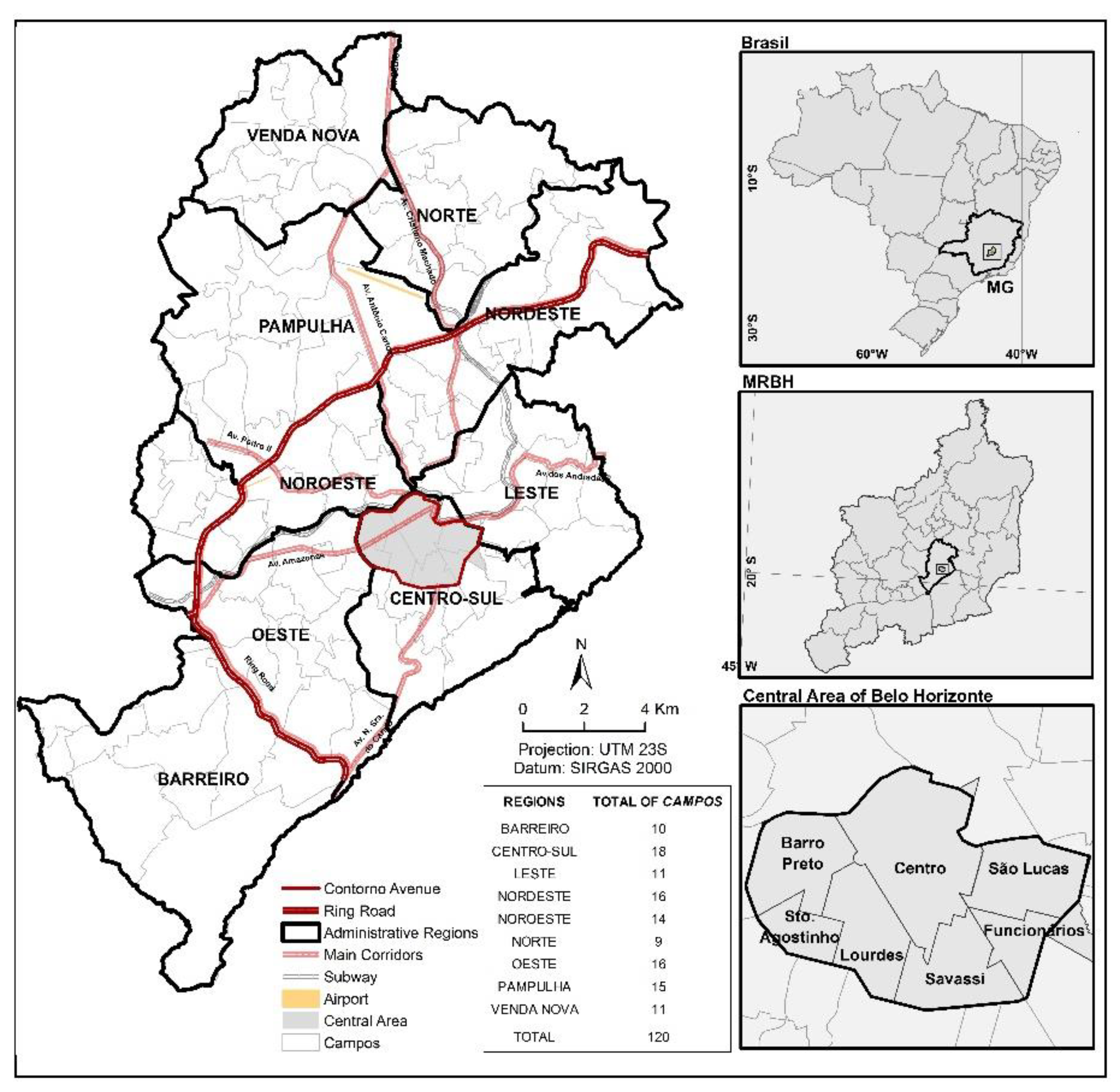
The present work has been methodologically conducted in two steps. In the first step, the level of centralization and power of attraction of the rides carried out by the Central Area of Belo Horizonte (
Figure 1) based on the travel flow by means of motorized vehicles including the following means of transport: buses, automobiles, motorcycles, and urban trains. In the second step, the evaluation of the supposed process of consolidation of the new centralities is made, taking into account the capacity of attraction of the rides as a result of a supposed rearrangement of the motorized flows in supposed subcenters and immediate surroundings. To do so, data extracted from the OD Surveys (2002 and 2012) have been applied allowing the production of the travel matrix inside the municipality and coming from the municipalities of its Metropolitan Region. A periodic sampled survey has been used, and its versions, last and next to last, were respectively prepared and made available by
Fundação João Pinheiro (FJP) and by
Agência de Desenvolvimento da Região Metropolitana de Belo Horizonte (
Agência RMBH) [
Belo Horizonte Metropolitan Region Development Agency], authorities linked to the Government of the State of Minas Gerais.
It is important to emphasize that the OD Surveys are considered the most complete database of people and goods transport demand. These surveys present information about the displacement carried out (i.e., reason, schedule, mode, origin, destination, and travel time) and about the population’s socioeconomics characteristics (i.e., age, education level, and income). In Brazil, the first OD Survey was applied in São Paulo in 1967 [
58]. The OD Survey of Metropolitan Region of Belo Horizonte (MRBH) was carried out for the first time in 1972, being repeated in 1982, 1992, 2002 and 2012.
For the first step, aiming processing and analysis, spatial units called
Campos (
Figure 1), which are aggregations of homogeneous areas (lower level of spatial disaggregation used in the ODs), were employed. The
Campos are spatial units fit to establish minimum samples of the local social and economic conditions that, in general, coincide with the cut of districts or small groups of districts of Belo Horizonte, making information management more accessible. In Belo Horizonte, in the OD Survey of 2012, 120
Campos were identified, distributed in the nine Administrative Regional Areas:
Barreiro,
Oeste,
Centro-Sul,
Noroeste,
Leste,
Pampulha,
Nordeste,
Norte and
Venda Nova (
Figure 1). In order to level the spatial units of the analysis, the
Campos of OD 2002 were made compatible to the OD 2012 base, taking for reference the HAs [
Homogeneous Areas] relative to the 2002 cut, overlapped with the
Campos of the 2012 division, considering the localization of the centroid as adjustment point.
To analyze the regional organization dynamics throughout ten years, and to evaluate the maintenance of the importance of the role of the Capital city’s center, observed by [
59,
60], the methodology applied in the work by [
60], who assessed the distribution of the motorized flows in the municipality of Belo Horizonte, was used. To this end, besides the flow lines to the Central Area of the Capital city, the flows with origin and destination in the same Administrative Regional Area and in different Administrative Regional Areas (named intraregional and interregional, respectively) were taken into account, as well as the flows to the Central Area, circumscribed by the zone within the boundaries of Avenida do Contorno (
Figure 1). In this sense, aiming to verify the weight of attraction that the Central Area displays in each
Campo, and how prevalent it is (or is not) regarding the intraregional flow, an indicator has been proposed by [
60], called Central Area Attraction Ratio (AR
CA) relative to 2002 and 2012 (Equation (1)).
where V
CAi stands for the number of rides originated in the i-th
Campo and destination to the Central Area, and V
INi the number of intraregional rides. In what concerns the possible results of Equation (1), the values equal to 1 indicate flows to CA and equivalent intraregional areas; values higher than 1, the prevalence of flows to CA; and the values lower than 1, the predominance of the intraregional flows.
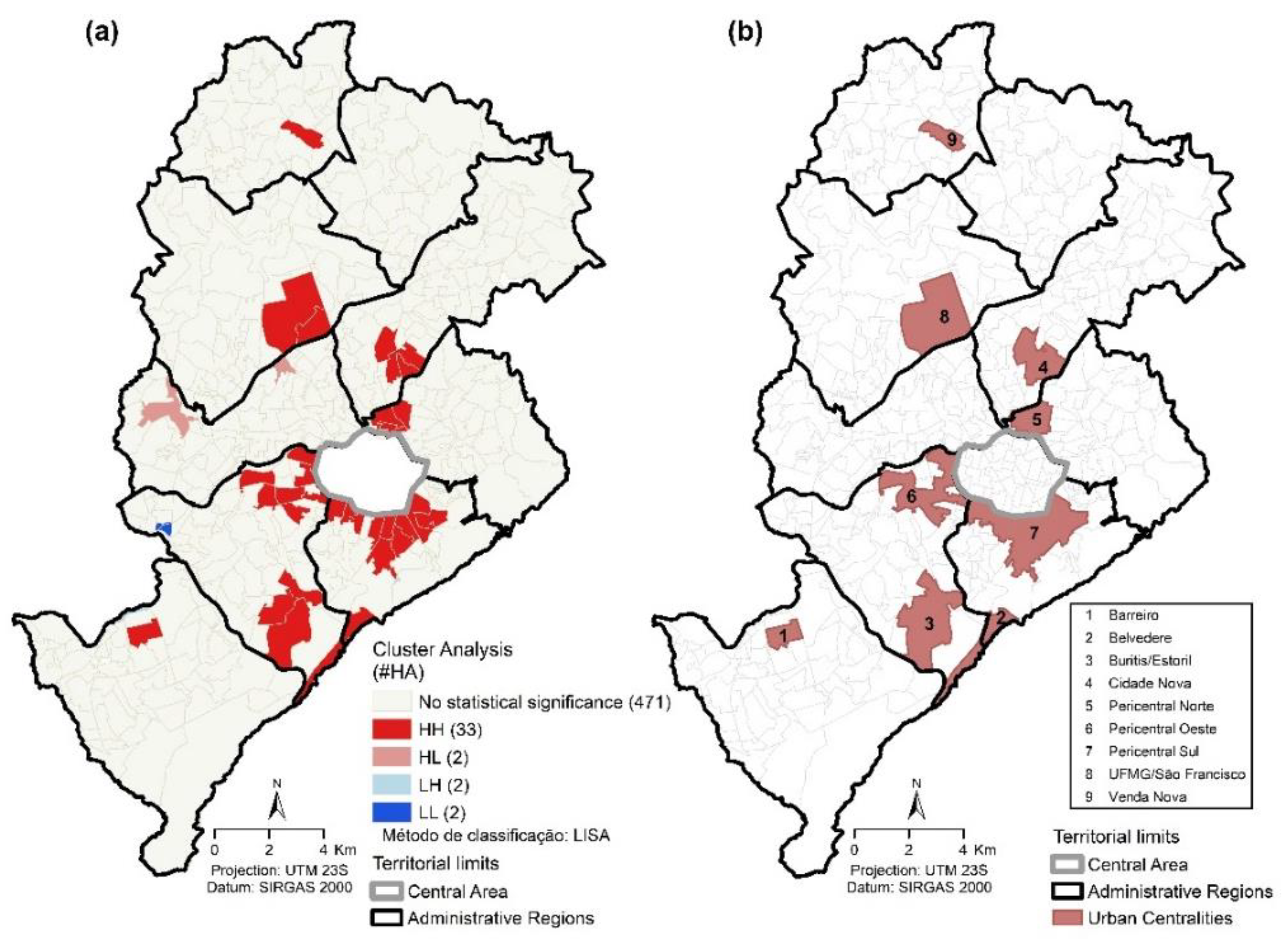
In the second step, the objective of which is to evaluate the supposed consolidation process of the new centralities in Belo Horizonte, the urban centralities defined as spatial groupings of HAs were considered using the Moran’s Method [
60], and they displayed high concentration of opportunities and high capacity of ride attraction (HH—High-High) outlined in
Figure 2a. The 33 HAs (HH) allowed to establish nine centralities, based on the proximity among the territorial units belonging to a same regional area (
Figure 2b), denominated according to the district localizations, to wit:
Barreiro,
Belvedere,
Buritis/
Estoril,
Cidade Nova,
Pericentral Norte,
Pericentral Oeste,
Pericentral Sul,
UFMG/
São Francisco, and
Venda Nova, distributed in seven of the nine regions of the Capital city. A centrality was recognized in each one of the following Administrative Regional Areas:
Barreiro,
Noroeste and
Leste (
Barreiro,
Cidade Nova, and
Pericentral Norte); and two in the
Centro-Sul (
Belvedere and
Pericentral Sul) and
Oeste (
Buritis/
Estoril and
Pericentral Oeste).
For the identification of the reorganization of the motorized flows to Belo Horizonte, considering the hypothesis of reduction of displacements to each one of these urban centralities, with the new logic of urban space structuring [
5], comparative analyses were carried out considering three indicators in 2002 and 2012: (1) The Weighted Average Distances (WAD) of the travel flows attracted by each centrality (Equation (2); (2) the total motorized flows attracted by each centrality; (3) number of HAs with origin of the rides heading to the centralities. Finally, aiming at evaluating the greater power of attraction of each centrality, an indicator named Centrality Attraction Ratio (AR
C) estimated for years 2002 and 2012 (Equation (3)) was proposed.
where D
i represents the Euclidean distance between an HA of origin centroid and the i-th centrality centroid, and V
i, the number of rides between an HA of origin centroid and the i-th centrality centroid.
where V
ai represents the number of rides attracted to the i-th centrality, and V
CAi, the number of rides originated in the i-th centrality and in direction to the Central Area. As a result of Equation (2), values equal to 1 indicate flows to the equivalent centrality and to the Central Area. For values higher than 1, the prevalence of the flows to each centrality is obtained.
4. Results and Discussion
In accordance with the 2002 and 2012 OD Survey data, there has been a general increase in the motorized flow among the municipalities of MRBH. Comparing the two decades, the total volume of rides increased from 6.3 to 13.1 M, arising, in a great part, from the demographic growth itself of the municipalities. On its turn, in Belo Horizonte, the internal motorized flows, in the same period, grew from 3.5 M to 6.0 M, standing for a 71.3% gross accrual. Moreover, as analyzed, the flows originating in MRBH heading to the metropolitan nucleus displayed an increase from 4.0 to 6.9 M, also standing for approximately a 71.0% accrual. Nevertheless, this growth took place in a very different way in the different modes of transport, and in the administrative regional areas of the municipality. More specifically, as for the motorized flow attracted by CA of Belo Horizonte, the increase is also remarkable: 39%. At last, still in accordance with the OD 2002 and 2012 data, one may observe that the prevalence of this attraction occurs within the boundaries of the municipality itself, which in 2002 presented 80% if the flow origin to CA and, in 2012, this percentage turned into 76%. Even with the increased attraction originated in MRBH (16.7%), the prevalence of the municipal internal attraction is more outstanding.
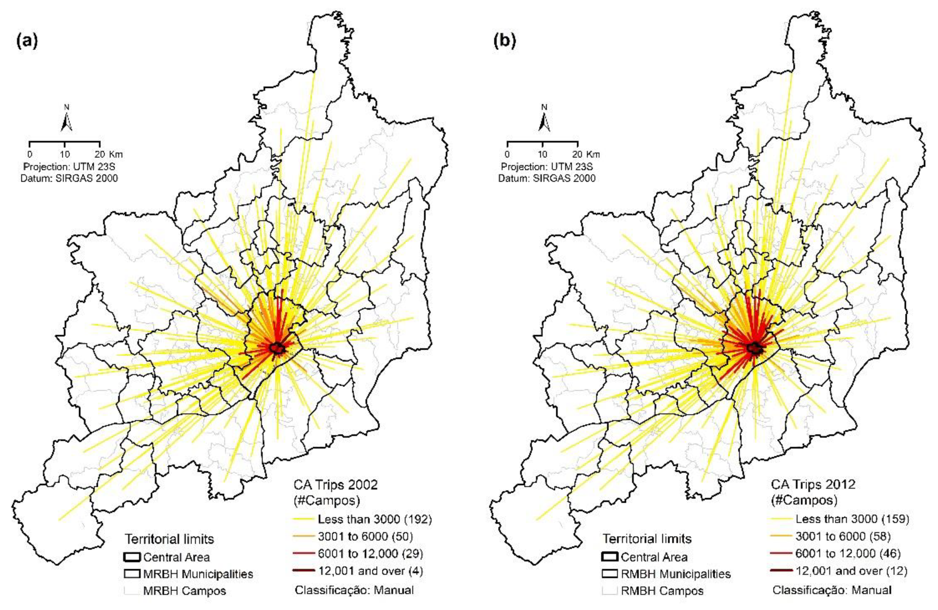
The increased power of attraction of the Central Area between 2002 and 2012 may be observed in
Figure 3. Based on the analysis of the cartograms (a) and (b) standing for the vector distribution by motorized volume, leaving the further
Campos of MRBH in the direction to the Belo Horizonte CA, one may observe the increase of those representing flows to higher than 6000 rides per day. In 2002, for this class, 33
Campos were counted, increasing to 58 in 2012. Stressing this evidence, the vectors representing low daily volumes of rides to CA displayed a decrease between the analyzed years. In 2002, 242
Campos were counted, falling to 217 in 2012, which represented a decrease of approximately 10%.
In general terms, as the cartogram analysis in
Figure 3 may confirm, this travel flows increase to CA occurred in almost the whole MRBH, especially in the north and west portions of the Capital, supported by important road corridors:
Amazonas,
Presidente Antônio Carlos, and
Cristiano Machado avenues. The last two are part of the so-called
Linha Verde (Green Line), a project launched in 2005, characterized by a set of road constructions carried out in the municipality of Belo Horizonte and its Metropolitan Region (MRBH), which may help understand the phenomena presented. More specifically, this increase occurred more evidently in the neighboring municipalities such as
Ibirité,
Contagem,
Ribeirão das Neves,
Vespasiano,
Santa Luzia, and
Sabará heading to CA. In what concerns the volumes originated in the municipality itself, the increase was more significant mainly in the
Campos located in the
Oeste,
Norte,
Leste,
Venda Nova,
Barreiro, and
Centro-Sul Administrative Regional Area where, according to [
60], a greater intraregional increment has been observed (origin and destination in the same Administrative Regional Area).
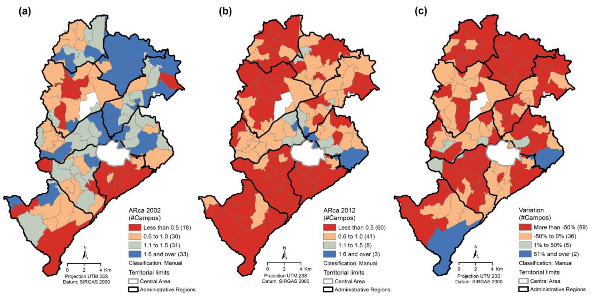
Figure 4 displays the dynamics of the spatial organization that spatially represents the CA Attraction Ratio (AR
CA) indicator, one may confirm that the increased predominance found in the intraregional flows in relation to the flows to CBD in the decade (AR
CA < 1). In 2002, 43% of the
Campos studied displayed flows directed to the CA of Belo Horizonte, and this percentage increased to 90% in 2012. In this sense,
Figure 4c indicates that in 94% of the
Campos studied in the decade presented a reduction of AR
CA, endorsing the hypothesis of a polynucleate city, suggested by [
21,
55,
61]. It is important to observe that this analysis was made for the internal rides of the Capital only, a choice justified by the prevalence of the internal flows previously observed. However, this has not always been the tendency of the flow distribution in the municipality. As may be observed in
Figure 4a, in 2002 there was a predominant displacement to CA (AR
CA > 1): approximately 57% of the
Campos studied presented flows mainly directed to CBD of the Capital.
Although the power of attraction of the Belo Horizonte Central Area is still significant, this indicator presented an average reduction of approximately 60.2% of ARCA. The predominance of the internal flows of the Administrative Regional Areas (ARCAaverage < 1) during the analyzed decade could be confirmed. Even the Centro-Sul Administrative Regional Area, which encompasses CA itself, presented a 47.8% decrease for this indicator. This loss of power of attraction was even more significant in the Norte, Venda Nova, and Barreiro Regional Areas, with decreases of 79.9%, 65.6%, and 65.5%, respectively. A likely explanation may be the concentration of important commercial, employment, and services subcenters, which may configure them as potential centralities.
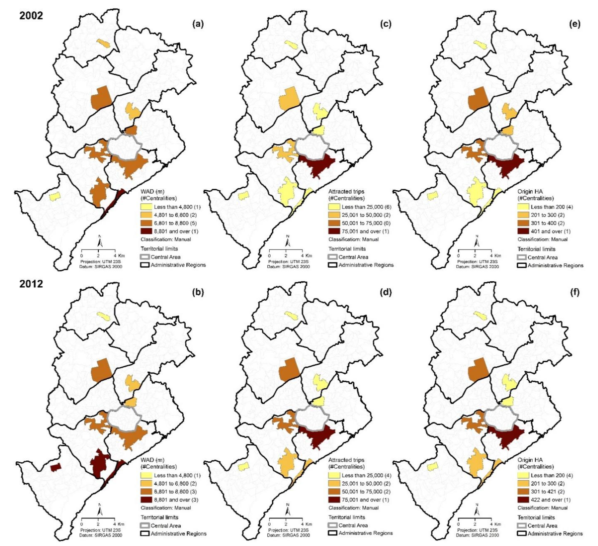
All evidence exposed suggests the existence, though incipient, of dispersion forces reflected in the motorized flows to certain urban centralities. The analysis in
Figure 5 stands for (a) the medium distance weighted averages, (b) total rides, and (c) number of HA originating motorized flows heading to the centralities between 2002 and 2012, which allows the identification of some specificities such as the prevalence of longer distances, mainly in
Barreiro and
Buritis centralities, greater frequency of connections, mainly in
Pericentral Oeste,
Belvedere, and
Buritis centralities, and major volume of the flows to the nearest centralities to CA, such as
Pericentral Sul,
Pericentral Oeste,
Buritis, and
Belvedere centralities, though they do not present substantial alterations in the spatial patterns already defined (
Figure 5).
Considering all the identified centralities in this article, WAD increased 64.9 km in 2002 to 68.2 km in 2012, in an average growth rate of 0.5% per year. Indicating, in general terms, an increased number and/or dispersion of rides between MRBH and the centralities along the decade. Moreover, the number of rides attracted in 2002 was 239,029, growing to 406,547 in 2012, displaying an annual average growth rate of 5.5%. Finally, concerning the number of HA originating rides heading to the nine identified centralities (
Figure 5), there has been an increase of 2224 to 2279 between 2002 and 2012, presenting an average yearly growth rate of 0.2%. In general, these changes seem to indicate positive effects of the municipal decentralization policy in accordance with the recommendations of the Ministry of the Cities, aiming to further the logic of multicentrality in the urban densification, decreasing the medium and long-distance ride flows [
5].
Table 1 shows specific data in relation to the annual average growth rates (AAGR) for each one of the indicators proposed in the methodology of the present work.
As for the power of attraction of motorized flows, the centralities presenting higher increments were
Buritis/
Estoril and
Belvedere, with annual average variations of 13.2%, 10.3%, and 6.9%, respectively. By contrast,
Cidade Nova and
Pericentral Norte centralities reduced the number of attracted rides, with annual average variations of −1.8% and 2.9%, respectively. In what concerns the spatial breadth of this power of attraction, represented by the WAD indicator, the centralities that ran to the opposite direction of the proposed by the Ministry of the Cities [
5] were
Barreiro and
Buritis/
Estoril, presenting annual average increments of the ridden distances of 9.1% and 0.5%, respectively. On their turn, the centralities that mostly concentrated the flows during the analyzed decade were
Cidade Nova and
Pericentral Norte, presenting 1.8% and 1.7% reductions in the WAD annual average growth rate, respectively. Finally, the analyzed numbers of HA originating rides heading to the centralities, one may confirm that all the analyzed territorialities were reduced regarding this indicator, the most relevant being:
Pericentral Norte and
Cidade Nova, with AAGR of 5.3% and 2.9%, respectively.
When each of the centralities is singly analyzed, based on
Figure 5 together with
Table 1,
Buritis/
Estoril stands out as the centrality that presented the major power of attraction, simultaneously with the increase of the dispersion and coverage of these flows, represented by the WAD upscaling along the decade, and the increased number of the Homogeneous Areas originating rides towards it. Such dynamics may be explained by the increased concentration of commercial and services facilities, besides schools and university centers that confirm the regional coverage of this subcenter. Likewise, the
Barreiro centrality also presented a much greater ride attraction, but the WAD increment was more significant, as well as the number of HA of origin, emphasizing the metropolitan character of this centrality, which may be justified by the importance of its industrial and commercial sectors for MRBH. With due proportion, the
Pericentral Norte centrality presented this same tendency along the decade.
The Belvedere centrality, in spite of the expressive increase of the power of attraction, followed, albeit timidly, the tendency of rides concentration between 2002 and 2012 (reduced WAD), with the particular increased number of Homogeneous Areas originating rides towards it, suggesting the regional character of this centrality that may be characterized as dynamic and more specialized commercial and services centers providing the high-classed demands of the local population. Other subcenters showing this same tendency were UFMG/São Francisco, Pericentral Sul, and Venda Nova. Thus, this phenomenon happened more locally due to a reduced WAD during the analyzed period. A likely reason for this fact is the specific dynamics and the large employment, commerce and services offer found in these centralities, and due to the endogenous relationship kept with its population that “consumes” what the subcenter itself offers. The Pericentral Norte centrality, in spite of the increased ride attraction, presented significant WAD and number of originating HA reductions suggesting higher local characteristics. At last, Cidade Nova was the only centrality that presented reductions in all indicators, evidencing its expressive loss of power of attraction related to motorized flows, and decreased spatial coverage.
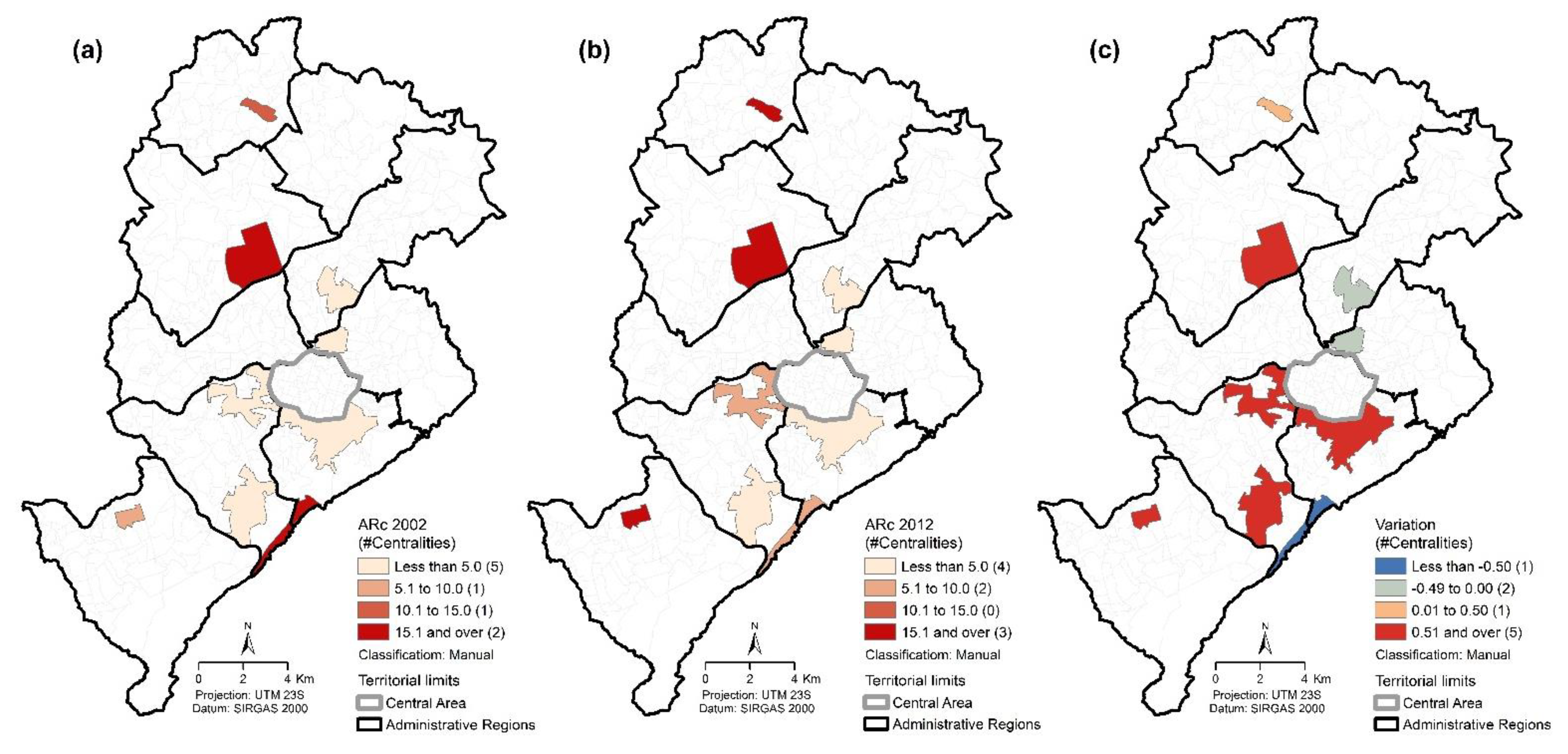
Aiming at evaluating the gain of power of attraction of each centrality identified in this study, the Attraction Ratio of the Centralities (ARc) has been proposed for the years 2002 and 2012, specialized and presented in
Figure 6. In the analyzed period, all the centralities presented ARc > 1, indicating the prevalence of the flows to the subcenters to the detriment of the travel flows to CA (
Figure 6a,b). However, when the ARc variations are observed, each territoriality presented different dynamics during the decade that may be construed as a gain or loss of power of attraction in relation to the polarizer center of the Capital city (
Figure 6c). Among the centralities that mostly gained force were
Barreiro,
Buritis/
Estoril, and
Pericentral Norte, displaying annual average growth rates of 11%, 10%, and 8%, respectively. Conversely,
Belvedere,
Cidade Nova and
Pericentral Norte centralities presented a loss of attraction with AAGR of −12%, −1%, and −1%, respectively. All the evidence supports the results already presented throughout this work.
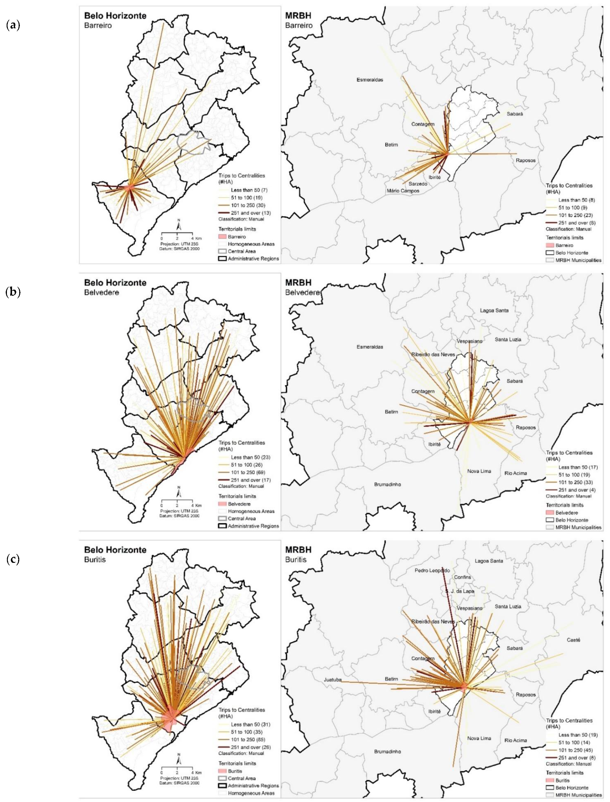
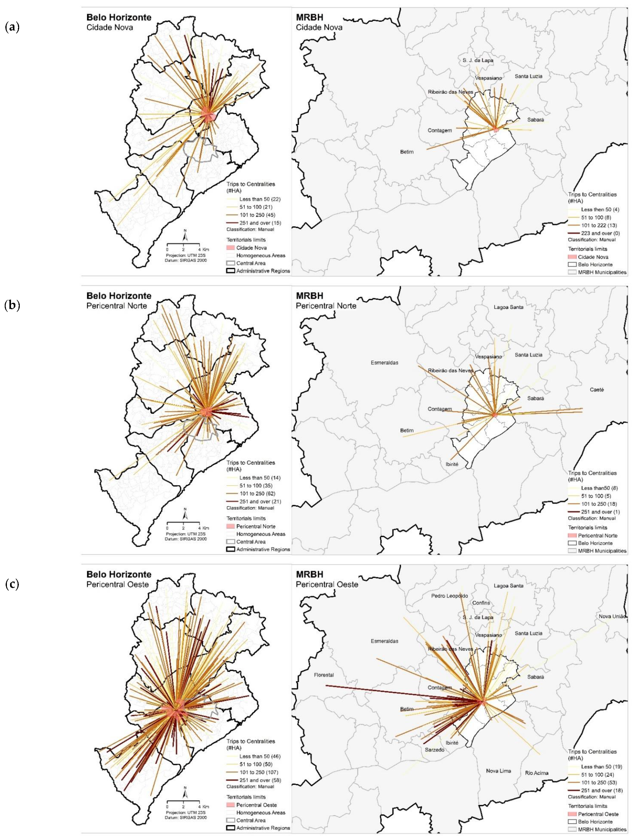
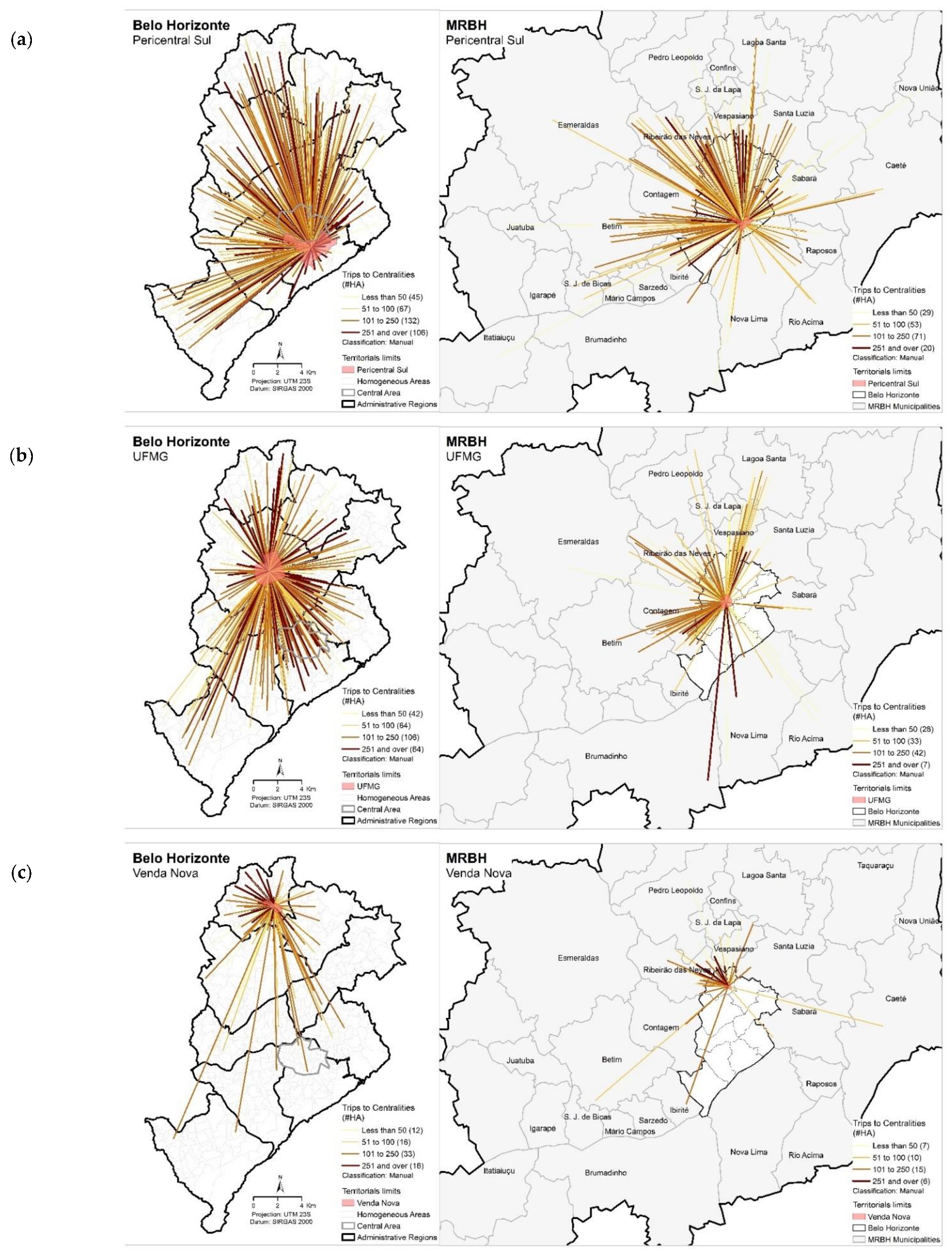
In order to detail the area of direct influence of each one of the identified centralities, the mobility vectors of 2012 were mapped. According to
Figure 7,
Figure 8 and
Figure 9, one may observe the abovementioned results very clearly. In general terms, the centrality that gained major metropolitan power of attraction was
Buritis/
Estoril, showing an annual growth rate of 6.2%, followed by
Pericentral Sul, and
Belvedere, with 2.4% and 1.0%, respectively. The result seems to confirm the fact that the centralities in question are responsible for a great ride attraction of the whole municipality, existing not only due to the local demand coming from the nearest neighborhood, but also due to the expansion all over the municipal and metropolitan territory, for several reasons such as work, studies, commerce, and services. Conversely,
UFMG/
São Francisco centrality was the one that mostly lost metropolitan attractiveness presenting an annual reduction rate of 5.5%, followed by
Cidade Nova and
Pericentral Norte centralities displaying 3.3% and 3.1% rates, respectively, indicating not only general loss of attraction, such as
Cidade Nova centrality, but also the concentration of these flows, as in the case of
UFMG/
São Francisco and
Pericentral Norte centralities that, in spite of the reduced spatial coverage, increased the power of attraction along the decade.


