Abstract
The accessibility of basic services in rural settlements in the South Moravian Region was evaluated; the accessibility by public transport was taken into account because the accessibility by individual car transport does not manifest any problems. The accessibility was calculated for 768 rural settlements, defined as spatially separate places which do not belong to municipalities with extended power. The time distance includes the time of the ride plus 8 min walking distance to and from the stop. The data was taken from the Integrated Transport System of the South Moravian Region, which ensures that each populated place in the region has to be connected by public transport at least six times on working days. The results show that for 99.8% of the inhabitants of the region, central places equipped with a post office, a basic school and a general practitioner’s office are accessible in a shorter time than 30 min. The accessibility of the services depends primarily on the characteristics of the settlement system and the physical conditions of the transport. In lowland areas, the share of settlements with comfortable accessibility is expressively higher than that of the highland and peripheral territories. The possible future improvement consists of the digitization of the services.
1. Introduction
Both Czech and European politicians warn of rural depopulation, rural abandonment and the lack of jobs in rural areas. Depopulation, ageing and the decline of services are considered interconnected features [1]. The inaccessibility of services can be considered an important factor of rural deprivation [2]. The accessibility of services can be considered to be one of the most important aspects of the creation of comparable living conditions in the whole territory of Europe [3]. The matter has frequently been discussed by both politicians and researchers [4]. The situation in different European countries varies substantially; however, general comparative studies are hardly available [5]. Conceptual documents on all levels usually suggest solving the situation with the creation of new agricultural jobs, or with the development of cultural tourism in rural areas.
One of the opportunities of cultural tourism which could be realized is being developed within the SPOT project (Social and innovative Platform On cultural Tourism and its potential towards deepening Europeanisation), which provides a new approach to cultural tourism to reflect patterns of travel in the 21st century for less favourable areas, as well as sustainable options for over-touristic places. It brings together partners from across the European Union and beyond to analyze the varieties of cultural tourism and how they can benefit host communities and regional economies. An important and innovative aspect of the project is that stakeholders are integrated into the project design. The output includes an innovation tool for analysing the potential for cultural tourism and its development. One of the important preconditions for the development of cultural tourism in rural areas is the accessibility of services by public transport.
In reality, the numbers and shares of the rural population in Moravia have been increasing since the mid-1990s, and the unemployment in the rural settlements is lower than the unemployment in their urban centres as a rule. Only villages in the most peripheral micro-regions without full-featured urban centres are threatened with depopulation. However, this fact is a result of their peripheral position, not their rurality.
What is the main problem of rural settlement in Moravia? The main problem consists of disappearing social services—shops, schools, post offices, medical offices, and even pubs and similar facilities. In the transformation period, the situation in rural services improved [6]. Such a development is preconditioned by decreasing numbers of customers. When the number of customers decreased under the sustainable level, the service became economically inefficient and had to be closed earlier or later.
Although such a situation could suit the majority of rural people, some groups are not able to—or for them, it is difficult to—commute to other places for services [7]. In general, they are people who are not able or allowed to drive—seniors, teenagers, people on parental leave, people who do not own a car. Such groups remain socially excluded. The literature pays attention, especially, to the access of elder adults to the services, e.g., Hubatková [8]. Such people often migrate to rural areas for a quiet milieu, but later they discover the bad accessibility of basic services, more often healthcare. Lehtonen et al. [9] suggest using so-called multi-local living, which is probably less accessible for the most endangered people. The situation can be partly solved by efficient, frequent and reliable public transport. However, a limitation of public transport is another issue that is frequently mentioned among contemporary rural problems. It is caused by decreasing passenger numbers as a consequence of the motorization of rural people. That is why public transport has to be supported by public sources. Berg and Ihlström mentioned that poor public transport services limit children’s and adolescents’ independent mobility in particular [10]. Inadequate public transport services are generally cited as one of the main rural problems in policy documents, as well as in the views of experts and citizens. Šipuš and Abramović [11] showed that 70% of their studied rural region is not covered by public transport. Similarly, Camarero and Oliva [12] stated that accessibility and mobility are strongly linked with rural well-being and social sustainability. The importance of the topic is also emphasized by the international project ACCESS’R (accessibility of services to the population in rural areas) for the years 2018–2021, which was focused on the availability of services in rural areas, and which was developed by 16 partners under the heading ‘LEADER France’.
However, more detailed analyses of the actual situation are missing. Is it not just a false myth, as in the case of rural depopulation, the high unemployment of the rural population and so on? All of these phenomena certainly exist, but they are not typical of the European countryside in general. Is it possible to ensure efficient public transport, despite the rural transport paradox, so that basic services for the rural population are accessible at a level comparable to cities? The paper is aimed at evidence of the accessibility of basic services of periodical use in rural settlements of the South-Moravian Region in order to discover the main regional discrepancies, to discuss their reasoning, and to formulate conditions for a solution. Specifically, it is a question of determining whether there are places in the region where the accessibility of basic services of general interest exceeds 30 min by public transport, including waiting times and walking from and to the station, and, if so, whether these places are regionally concentrated, and which part of the region’s population lives in them.
2. Literature Review
Rural sustainability or the sustainability of rural development, like the sustainability of any other territory, consists of three pillars—economic [13], social [14] and environmental [15]. Some authors add institutional sustainability to this. In the Fordist period, rural sustainability was associated primarily with agricultural production [16]. Due to certain inertia, the development of agriculture, in particular, is still supported in rural development. There is also sometimes talk of energy sustainability in rural areas. However, in the post-Fordist period, the emphasis is more on the consumption of rural landscapes and rural settlements for housing [17], business and tourism. In extreme cases, there is a risk of the depopulation of the countryside [18] and the extinction of some rural settlements as places of permanent housing. Sometimes, immigrants are seen as rescuers [19]. From the rural point of view, it is possible to consider the sustainability of the countryside as a rural space and the change of the countryside into a kind of urban–rural continuum under the pressure of urbanization processes. Rural identity is important in this sense [20]. Some authors prefer place-based approaches to rural sustainability [21].
In a situation where the issue of rural sustainability is shifting from the Fordist to the post-Fordist conception, the key issue is the quality of life of local people, tourists and entrepreneurs. Technical and social infrastructure is essential for it. At the local level, it is about the availability of basic functions of public interest. These are, for example, primary schools, doctor’s offices, post offices, or financial services and the like. This is not a serious problem for residents who have their own means of transport and commute to major settlements for work. Crucial is the availability of services for residents who depend on public transport, such as children, the elderly, the disabled, mothers with small children, or people who cannot afford their own car or more cars in the family [22]. Weaker social infrastructure is a feature of rural settlements, as shown by Mitrica et al. [23] in the example of Romania. However, the acceptable accessibility of these services by public transport in resorts and small towns should be ensured. The development of public transport in rural areas should decrease rural–urban migration.
The geography of services is based on Christaller’s [24] central place theory, which was later developed by Lösch [25] and criticized by many authors from different viewpoints, such as Vionis and Papantoniu [26]. The theory of central places is based on an imagining of a regular settlement structure which is not disturbed by any natural or political barriers. It is also based on the assumption that people and service providers act rationally, which is not always fulfilled. Therefore, some authors believe that this is an excessive simplification of reality. Christaller’s theory is often criticized as static. However, in a rural area, of which the settlement structure is relatively stable, it corresponds to reality better than it does in an urbanized post-industrial area, where there is a different interconnection of services and settlement structures. Of course, Christaller’s theory did not envisage the construction of hypermarkets at highway junctions or the digitization of some services, which may also change the overall picture. However, the basic rules of the central place theory were valid within the productivist society. Only in recent times have the development of shopping centres outside of traditional cities [27], the digitization of services [28] and the overcoming of micro-regionalization [29] started modifying the situation.
In Czechia, the central place theory was used in the period of the centrally planned economy in the form of the so-called Central Settlement System. The centres created a hierarchy: the capitol, centres of regional importance, centres of district importance and centres of local importance. The non-central settlements were divided into settlements with and without permanent importance. This measure was often criticized because of its top-down decision approach, ultimate character and the building ban in non-central settlements without permanent importance. However, the idea itself was logical, based on scientific knowledge and being supported by centrally planned public transport. This approach ensured more or less optimum access to the services for all inhabitants of the countryside. The Centre Settlement System was abandoned in 1990.
For the countryside, centres of local importance (small towns and large villages as a rule) were important. According to the central place theory, services are concentrated in central places to ensure a necessary number of customers from the central place and the sphere of its influence. In the Moravian conditions, small towns (up to 15 thousand inhabitants) play a decisive role [30]. According to Kašparová and Půček [31], about 1000 micro-regional centres offering basic social services of about 6250 municipalities can be found in Czechia.
In the period of the post-industrial transition, services are predestined to be the main drivers of rural development [32]. In the rural space, services can be divided into those which serve mainly the local people and those which serve other people—tourists, as a rule. The second type, which could have a seasonal character, is frequent, especially in tourist areas. Services (sometimes called the third sector) have a strictly hierarchical character which partly copies the administrative division, with many exceptions and deviations.
The issue of the availability of basic services has been addressed in British geography since the 1970s and 1980s [33,34]. These works point to the vicious circle of public transport. This topic is extremely important in sparsely populated areas [35]. In addition to the problem of availability of services in sparsely populated areas and developing countries, the problem of the disappearance of services from the countryside as a result of the increasing motorization of people or the construction of suburbs in which services were not envisaged at all became more important. For understandable reasons, the greatest attention is paid to the availability of medical services, e.g., Shah et al., [36], and less frequently the accessibility of schools [37]. Some works focus on specific topics, such as the accessibility of police stations [38].
The vicious circle of rural public transport stems from the fact that as the motorization of the rural population increases, the demand for public transport decreases, making its operation economically inefficient. This leads to the vicious circle [39], meaning the disruption of lines and connections so that the local population is even more dependent on individual transport and public transport. However, there is still a group of people, e.g., seniors [40], who cannot use individual cars; this group is at risk of social exclusion and their quality of life is declining. In addition, this trend has environmental consequences. The mass use of individual transport leads to the traffic congestion of destinations and associated exhalations, noise, parking problems and the risk of accidents.
The previous works have mostly stated the above problem on the basis of the sociological knowledge and feelings of the rural population [41], without examining the specific availability of public transport services on the basis of real times and conditions. In addition, many works focus on a specific service. Solutions are sometimes sought in alternative forms, such as flexible transport services [42], shared transport and, more recently, the development of digital services, which only partially solves the problem. Sometimes combined transport is proposed, such as bicycle–train [43], which, however, requires additional infrastructure. There are also considerations about optimizing public transport lines with the help of smart technologies [44], which does not solve the problem of marginal territories and marginalized groups of the population. So-called flexible integrated transport services are another variant of a solution [45]. Other experts reverse the problem: they study how transport systems affect the distribution of services, speaking more about the integrated land-use [46].
Although the idea of integrated transport systems is by no means new, the availability of rural services is not the focus either. It is most often about the accessibility of large cities or agglomerations from their rural hinterland, often in oversized cities in the developing world, e.g., [47]. Unlike most other contributions, our article focuses on the accessibility of basic services of general interest in rural areas (i.e., not on their accessibility for rural people in large cities); it is based on the analysis of exact data (not on the subjective feelings of rural people) and works with integrated transport systems, which only make it possible to achieve the real availability of services in the current period.
Transport geography most often deals with accessibility at the regional level. As shown by Rosik et al. [48], the poorer availability of higher-order services affects the overall economic development of the region, measured, for example, by GDP per capita. However, our analysis deals with the local level. The accessibility of services depends on transport systems. The Spatial Interaction Model [49] is used to model traffic flows. However, our work is not about traffic flows, but about the availability of services. The frequency of connections is determined by the rules of the Integrated Transport System of the South Moravian Region. Whereas in the case of individual transport the time distance is usually the most important factor, in the case of public transport the frequency plays a role besides time comfort [50]. Insufficient public transport can lead to the social exclusion of the threatened population who depend on the accessibility of rural services.
3. South Moravian Region: A Case Study
The South Moravian Region is an NUTS 3 region according EU terminology. It is situated in the south-eastern part of the Czechia–Austria–Slovakia borders. The region has 1,188,000 inhabitants (2019) in the area of 7188 km2, which manifests a population density of 164 persons per km2. Although it is well accessible from the capitals of neighbouring countries (Vienna, Bratislava and Budapest), it is relatively peripheral both from national and European viewpoints.
3.1. Settlement System
The settlement system of the region is led by its metropolis Brno (381 thousand inhabitants, 2019). Brno is the historical capital of Moravia and its functions across the regional borders. The regional capital is followed by five district towns with populations of 21–34 thousand, which can be considered as medium-sized towns. In total, 44 small towns with under 12 thousand inhabitants form the skeleton of the settlement system. Additionally, 34 so-called authorized municipal offices ensure administrative services for their rural hinterlands. These areas represent the lowest level of administrative services.
The remaining 622 municipalities can be classified as rural ones. Some of them contain further spatially separated settlements. The region is typical, with large rural settlements which cross populations of a thousand or even two thousand in the southern and central part of the area, whereas the settlements in the northern part and the periphery are smaller. This is important for the accessibility of services because large villages have their services on the basic level although they do not have any central function, whereas smaller villages on the periphery depend on commuting as a rule. The characteristics of the region were elaborated upon by Vaishar et al. [51].
3.2. Transport Network and Accessibility
Brno is the main node of all kinds of long-distance transport. Apart from Brno, Břeclav is an important railway junction. The lines from Hamburg to Bucharest and from Warsaw to Vienna cross here. Significant roads and railways lead through the valleys of the Morava, Svratka and Dyje rivers. On the contrary, the borders of the region are largely formed by highland zones, the overcoming of which leads through more complex terrain. However, long-distance transport is not the subject of this study, which instead deals with accessibility on the local level.
In the region, there are 785 km of railways, 160 km of motorways, 422 km of first-class roads, 1468 km of second-class roads, 2394 km of third-class roads, 45 km of navigable waterways for public transport (Statistical Yearbook of the South-Moravian Region 2019, Czech Statistical Office Praha) and one international airport. In 2018, road transport transported 68.5 million persons, whereas railway transport transported 21.3 million persons. There were 594.8 thousand cars registered in the region, which represents almost exactly one car per two inhabitants. The highest intensity of the road transport is reached in the southern access to Brno (69.4 thousand vehicle units per 24 h, 27% of it being formed by the freight transport, 2016; Census of the road transport 2016, Directorate of Roads and Motorways Praha) and in the transitional roads. The load of the roads in the region in 2016 is shown in Figure 1 (the results of the 2020 traffic census are not yet available due to the COVID-19 pandemic).
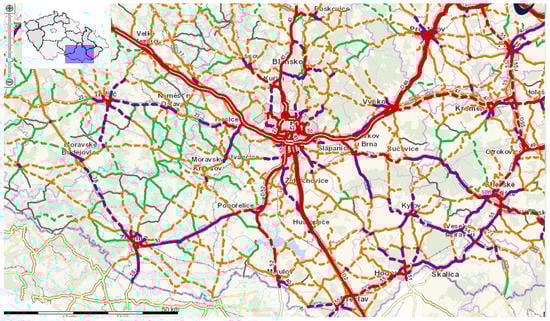
Figure 1.
The load of roads and motorways in the South Moravian Region in 2016. Source: Celostátní sčítání dopravy 2016, ŘSD ČR (Ředitelství silnic a dálnic ČR/ Directorate of Roads and Motorways CZ).
In rural areas, the intensity of transport is no problem as a rule. However, the quality of the transport infrastructure is sometimes problematic. Roads of higher categories are often overloaded and damaged by heavy freight transport, whereas the maintenance of roads and railways of lower categories has been poor in the past. As a consequence of it, a big part of the infrastructure is under maintenance or reconstruction, which creates frequent bypasses and makes transport slow.
3.3. Integrated Transport System of the South Moravian Region
The public transport in the region is unified within the Integrated Transport System of the South Moravian Region. The system includes 24 state-owned, municipal and private transport companies. With 322 transport lines, it ensures the connection of all of the communes of the region and 57 additional municipalities in neighbouring regions and countries. It is owned by the South Moravian Region and the City of Brno.
The system is based on a skeleton of radial communications (mostly railways). Transfer nodes were built on these skeleton lines. Regional buses ensure the transport from individual settlements to these nodes. This means that the buses operate on short distances, which enables a high frequency of connections. It is actually a feeder-trunk system applied to rural space, which can be compared with [52]. The remaining buses are used for tangential and alternative connections. Similar nodes were created on the fringe of Brno, enabling changes to the city transport not going to the inner city. As a result, only electric vehicles pass to the inner city of Brno.
According to the rules of the system, each inhabited place in the Region has to be covered by at least by six connections of public transport on working days, and by three connections on weekdays. The longest walking distance between each inhabited house and the closest station of public transport may not cross 2000 m (taking into account local conditions). The time of a change between the bus and train may not cross 10 min, including walking between the stations.
The system has a uniform timetable, in which the individual connections follow each other and, if necessary, wait, even if they are operated by different companies. In the case of unexpected events, there is a fleet of substitutional buses located at transport hubs, which allows problems to be solved operatively. Everything is controlled from a single operations centre. Passengers have a uniform fare, which guarantees the same price for transport from one place to another, regardless of the means of transport used or their combination. The system is gradually being digitized, including the possibility of monitoring the position of individual vehicles on the route through mobile phones, electronic fare payments, ordering special transport (for example, for the disabled) and the like. Vehicles are also gradually being modernized in favour of low-floor air-conditioned vehicles equipped with WiFi, and in the territory of cities also in favour of electric and gas drives.
Such a system cannot be paid for exclusively by the fare. Not directly the passengers but municipalities are customers of this system. The municipalities order the connections. The providers are not paid according to the number of passengers transported but according to the transport distance and number of connections. Public transport is understood as a public service, and the providers apply for tendering procedures.
3.4. Services under Investigation
The state-owned enterprise Czech Post (Česká pošta, s.p.) originated in 1993 along with the separation of Czechoslovakia. The state-owned Czechoslovak post was a monopoly supplier of post and communication services within the centrally planned economy. Within the transition to the market economy, the post-service was divided from the communications and the market was opened for private subjects. With about 30,000 employees, the company is the second-largest in the country. Although the company seeks to expand its services, the digitization of communications and the competition of delivery entities is gradually reducing its turnover and leading to a reduction in the number of employees and the closure of branches. Nevertheless, the company is obliged to guarantee postal services throughout the country.
The problem of rural schools’ disappearance in Czechia was highlighted by Kučera and Kučerová [53]. Individual municipalities are founders of basic schools. The numbers of pupils are taken into account in the budgetary allocation of taxes. In 2018, there were 473 basic schools with 95,654 pupils. The main decrease of rural schools was observed after 2006 with the onset of weaker population cohorts. By now, the closure of schools has slowed down considerably. Two other reasons are preconditioning the negative trends: the lack of teachers willing to teach in rural schools, and the opinion of some parents that urban schools have a better quality—whether justified or not.
General medical practitioners operate based on contracts with health insurance companies. Their reimbursement depends on the number of registered patients and actual interventions. This is not a problem, as patients are not shrinking and surgery rates are increasing due to ageing. The problem consists of the ageing of doctors and nurses. The average age of a practitioner is 55, and about 23% of them have crossed 60 years. There is hardly any substitution for retired doctors, who are connected with local communities and know local conditions in rural areas. Graduates of medical schools who have invested a lot of effort and resources in education are looking for their rapid career abroad or in cities.
3.5. Importance of Services for the Development of Cultural Tourism in the Region
Cultural tourism has many forms, and even rural areas provide advantages—recently concerning the anti-COVID measurements. Once existing cultural tourism attractions and sites in the region are identified as ‘hot spots’ in terms of cultural stock that are developable for tourism activity and distinguished by the category of a cultural theme, the feasibility of establishing attractions in any given ‘hot spot’ based on geographical and environmental conditions, including climate, is estimated. Here, it is necessary to evaluate the current as well as the potential access to the designated attraction (given potential transportation infrastructure development scenarios).
4. Methods
Some authors use GIS to analyse the accessibility of rural services [54]. This approach makes it possible to determine the geographical position of service places concerning the distribution of the population and the geometric distance between service places and places of residence. When measuring the availability of services, jobs or other activities, the aspects of time, geometric distance or cost can be used. When it comes to public transport on a local scale, time is the optimal indicator. Geometric distance is not decisive for passengers. Fare prices are usually also the same within one tariff band.
Time distances are easily ascertained from public transport timetables. In the case of competing means (car, bicycle, walking), it is possible to use data from the mapy.cz portal, which calculates the relevant geometry and the time distance between any two points in Czechia and most of Europe. Unlike large and medium-sized cities, traffic jams do not need to be taken into account, as they occur only temporarily in rural areas due to maintenance or accidents.
Primary research uses micro-regions based on the gravitation zones of municipal offices with extended competencies. Small towns are the centres of such regions in the rural space as a rule. In these towns, basic over-local administrative functions are located, as well as the basic level of education, medical care, post offices and specialized shops. That is why the accessibility of municipal offices with extended competencies is considered the most important for an analysis of the accessibility of services in rural spaces.
The accessibility to the mentioned services in Brno has not been taken into account. The transport conditions in a big city are quite different from those in rural areas. Individual transport is slow because of the traffic jams, crossroads and difficult parking conditions; the public transport is slower due to the number of stops and necessity of changing. In reality, it hardly makes any sense to commute for the basic services in Brno unless it is connected with other activities (more often with jobs or services of higher rank).
The accessibility of services in district towns was calculated, but situations in which the searching of services in district centres is efficient are rare. In general, the speed of transport in urban territories is expressively slower. It concerns especially public transport due to many stops, and because their lines to serve the maximum number of passengers do not always use the most direct route.
The database on the municipal level (Města a obce online. Portal of territorial self-governance. Available at https://mesta.obce.cz/, accessed on 5 April 2021) contains the localisation of post offices, basic schools and medical offices. These three examples illustrate very important services from the social viewpoint, and cover all of the age and social categories of the population.
Although the municipal structure in the Czech Republic is extremely dispersed, some municipalities consist of more spatially separated settlements. These settlements, especially, are often without basic services. That is why the accessibility of services was calculated for these settlements under two conditions: they have an official status of “part of the municipality”, and they are spatially separated. Municipalities with extended powers were excluded from being considered for centres of services. As a result of this, altogether 759 rural settlements were taken into account in the investigation.
The accessibility of centres for individual services and the centres which have all of the services under investigation was calculated.
The accessibility of services by individual car was measured as the fastest distance through the server mapy.cz, which contains a sufficiently detailed database of settlements and distances. The distance will usually be measured between the centres of the source and destination municipality, or part of the municipality. To the pure ride, 4 minutes were added in order to take into account the preparation time at the beginning and the parking time at the end of the ride. We assume that the advantage of using a car is the possibility of travelling door to door. That’s why we do not count walking time here.
For the sake of completeness, it should be added that the use of a bicycle is also conceivable, which can be effective over short distances. However, in our research, we are dealing with a 30-min limit on public transport, which precludes the use of a bicycle.
As the entire South Moravian Region is completely covered by the Integrated Transport System of the South Moravian Region (ITS SMR), the timetables of this organization will be used for the analysis. The principles of the integrated transport system prescribe at least 6 double connections in working days from any inhabited place in the region, which is sufficient for the accessibility of services (although sometimes it could be perceived as less comfortable). Consequently, it is not necessary to investigate the frequency of connections in this case. The time distance is measured as the time between the (central) stations of the source village and the central place. In some cases, stations are not situated in the centres of municipalities but rather in a position better accessible from the main communications (on crossroads). That is why the distance by individual transport and public transport does not need to be measured between identical points.
To the pure ride time, 8 min were added in order to take into account the walking distance to and from the station, and the waiting time. In reality, these losses of time can vary substantially. It was presupposed that local people know the situation very well and can minimize time loss. Besides this, the integrated transport system makes it possible to monitor the real position of the vehicle on the route via PC or mobile phones, thus minimizing waiting times. According to the ITS SMR rules, the walking distance from any inhabited place in the region may not cross 2000 m, taking into account local conditions, but in reality, a 30 min distance to the closest station is an exception that applies in extreme cases, which should be solved individually. This is theoretically possible because of the mapy.cz database enables us to give walking, cycling and driving distances between any houses or points, but it goes beyond our contribution.
5. Results
5.1. Accessibility According to the Media of Transport
The pure time of a ride differs by 0–2 min in favour of individual transport. On the other hand, public transport tends to be faster if it takes place by rail. The accessibility by public transport is usually about 5 min longer due to the time added for walking to and from the stop. The situation changes in urban territories, where the public road transport is substantially slower due to the higher density of stops and more complicated transport conditions. That is why it makes hardly any sense to take into account the commute to Brno in the case of the basic services, because the moving both by individual and public transport in the urban territory is much slower than in the rural space. Similarly, commuting to medium-sized towns for basic services is often less favourable in comparison to commuting between rural settlements. Time differences between individual and public transport may be important if the nearest service is located in a location other than that of direct public transport. In general, individual transport allows for multiple alternatives when choosing a destination.
It has been shown that the nearest centre of basic services is reachable within 10 min by individual transport for half of the rural settlements, and only in 8% of cases does this time slightly exceed 15 min. The accessibility of basic services by individual transport is therefore not a problem for motorized rural residents. Thus, it makes sense to address accessibility through public transport in the next analysis.
5.2. Accessibility According to Services
Altogether, 759 villages of the South Moravian Region were investigated. Of them, 19.9% possessed the complete spectrum of basic services: post office, basic school and medical office. In more than 80% of them, at least one of the services under investigation was missing.
Of the remaining villages, for 22.1%, the centres of complete basic services are reachable within 13 min (5 min ride + 8 min walking and waiting). This means that for 42% of settlements, their central places are available in 13 min or less. On the other hand, for 8.8% of settlements, the time to reach local centres is 24 min or more. In 2.5% of cases, the time crosses 30 min.
The availability of individual services (post-offices, basic schools and general practitioner’s offices) can be seen in Table 1.

Table 1.
Availability of services (% of settlements).
Post offices are the most available services in rural spaces. In total, for 61.6% of settlements the service is available within 13 min or less by public transport, whereas only 0.7% of settlements are available within 30 min and more. This could be conditioned by the fact that accessibility is the basic aim of mailing services. Basic schools are less accessible. However, for 56.1% of rural settlements, the service is accessible within 13 min or less, whereas for 1.4% of settlement it is distanced 30 min and more. General medical services are the worst to achieve. However, even in this case, more than half of the settlements are reachable within 13 min, while the worst reach is similar to that of schools.
5.3. Regional Accessibility
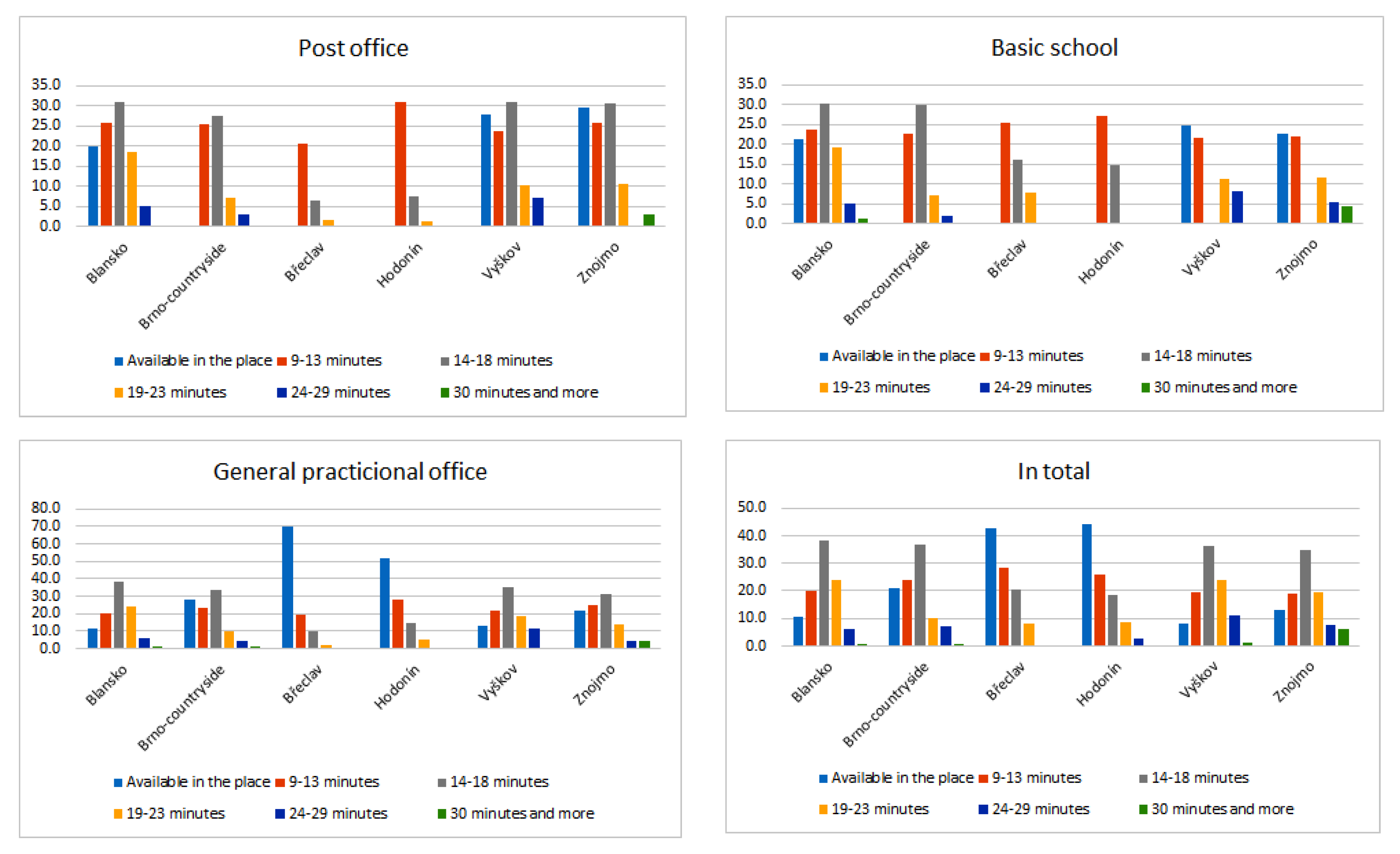
The accessibility of services according to administrative districts (NUTS 4 regions) is visible in Table 2. The whole set of regions is divided into three groups. The first one with the best accessibility of services is formed of the two southernmost lowland districts, Břeclav and Hodonín. The settlements with the worst accessibility of basic services are situated in the northern, more mountainous, districts of Blansko and Vyškov, and the district Znojmo on the south-western periphery. The district Brno-Countryside, in an average situation, is situated in the transition between the lowland and mountainous part of the region.
Table 2.
Accessibility of services according to administrative districts (% of settlements).
There are villages where the post office, basic school and medical office are concentrated in lowland micro-regions south and east of Brno. In this part of the region, there are large villages with a thousand and more inhabitants which have a sufficient number of customers. In other micro-regions, the complete services have mostly local centres.
The villages with the worst accessibility of the services under investigation are concentrated in the micro-regions in the south-western part of the region (the western part of the Znojmo district), in the micro-region of Tišnov northwest of Brno and in the micro-region of Vyškov, where the area is partly impermeable due to the military training area of Březina. There are micro-regions situated in the inner periphery, partly in the highland territory of the Bohemian–Moravian Highland and the Drahanská vrchovina Highland. These are small and very small villages situated in river valleys with limited alternative transport directions.
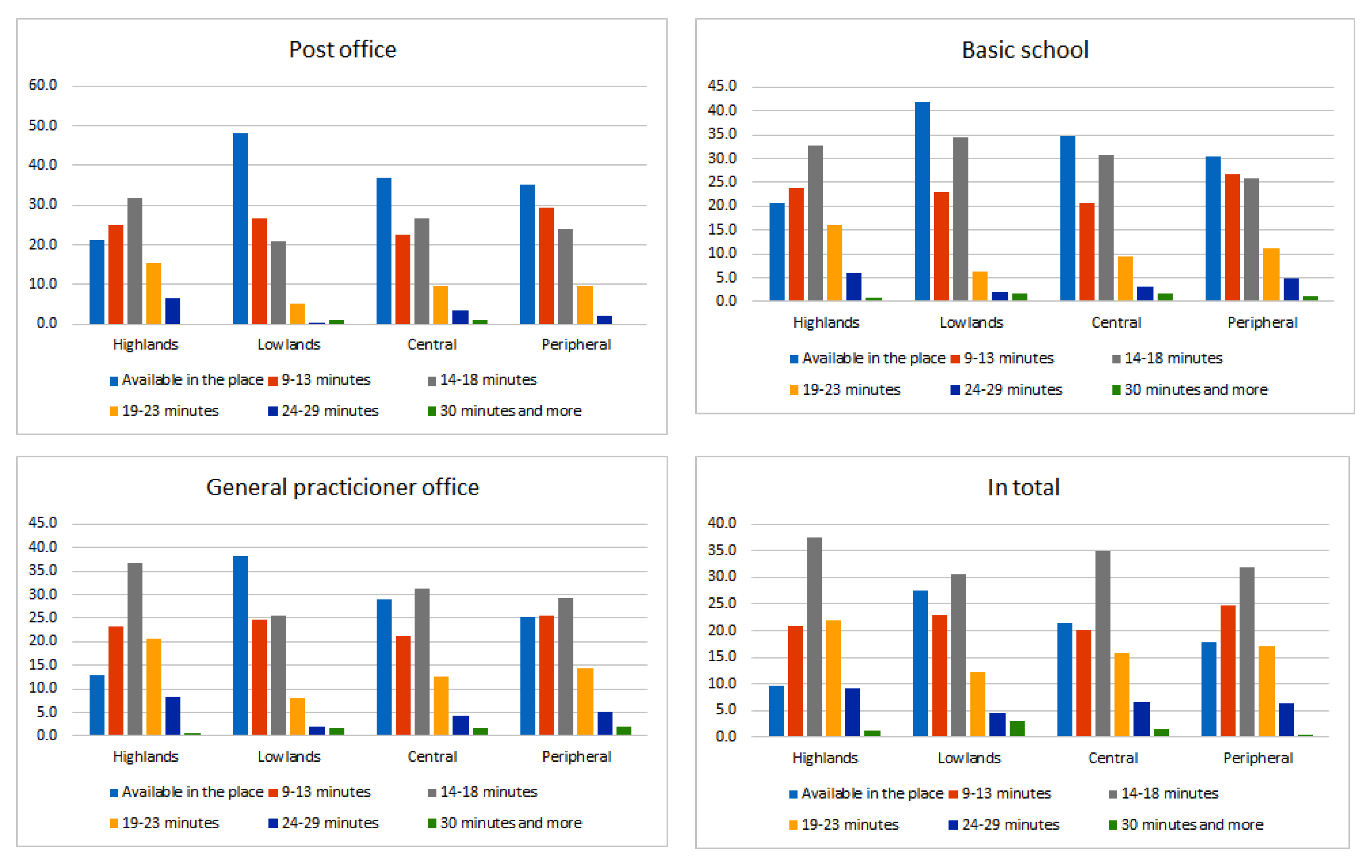
The data from Table 2 and Figure 2 calls for a more detailed analysis according to the lowland/mountain and central/peripheral parts of the region (Table 3, Figure 3). The districts of Blansko and Vyškov, and the micro-region of Tišnov, were classified within the highlands, and the other districts are lowlands. The countryside of the Brno district and the micro-regions of district towns were classified within the central category, and the others as peripheral. The results are presented in Table 3.
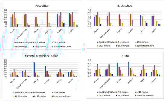
Figure 2.
Shares of settlements in the individual accessibility zones by district and total. Source: own processing.
Table 3.
Detailed analysis according to the lowland/mountain and central/peripheral parts of the region.
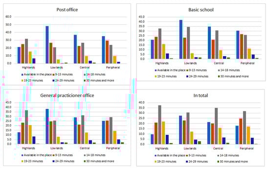
Figure 3.
Shares of the settlements in the individual accessibility zones by the geographical positions of settlements. Source: own processing.
As was expected, the share of the settlements with comfortable access to basic services (villages with their own services and those with access within a maximum of 13 min ride and walk) is higher in the lowland and central parts of the region. Surprisingly, the share of settlements with extremely bad access (30 min and more) is not very different in the various types of micro-regions; the situation in the highland and peripheral areas even seems to be a bit better.
Two explanations could be the following. Central regions are larger, with strong centres. Services in these centres may manifest too much competition for services in smaller localities, which can terminate. Concerning longer distances and slower transport on the territory of bigger centres, the time to reach the services can be longer in extreme cases. The second possible explanation is connected to the ability of the integrated transport system to balance the disadvantages of highland micro-regions in the delimitation of services.
The majority of the settlements with extremely unfavourable accessibility to basic services are concentrated in the Znojmo district. Čermákovice (distant 30 min) and Horní Kounice (distance 34 min) can be found in the Moravský Krumlov micro-region. They have 394 inhabitants altogether. There are centres which are well-reachable by car in the vicinity (Rouchovany, Dukovany, Višňové), but the public transport is directed to the macro-regional centre.
North-west of Znojmo, Vranovská Ves (301 inhabitants, accessibility 35 min) and Podmolí (168 inhabitants and 33 min accessibility) can be found. The time distance is a result of commuting to the second largest town in the region. The fringe of Znojmo is accessible in a short time, but the traffic from the fringe to the centre of the town equipped with services is high.
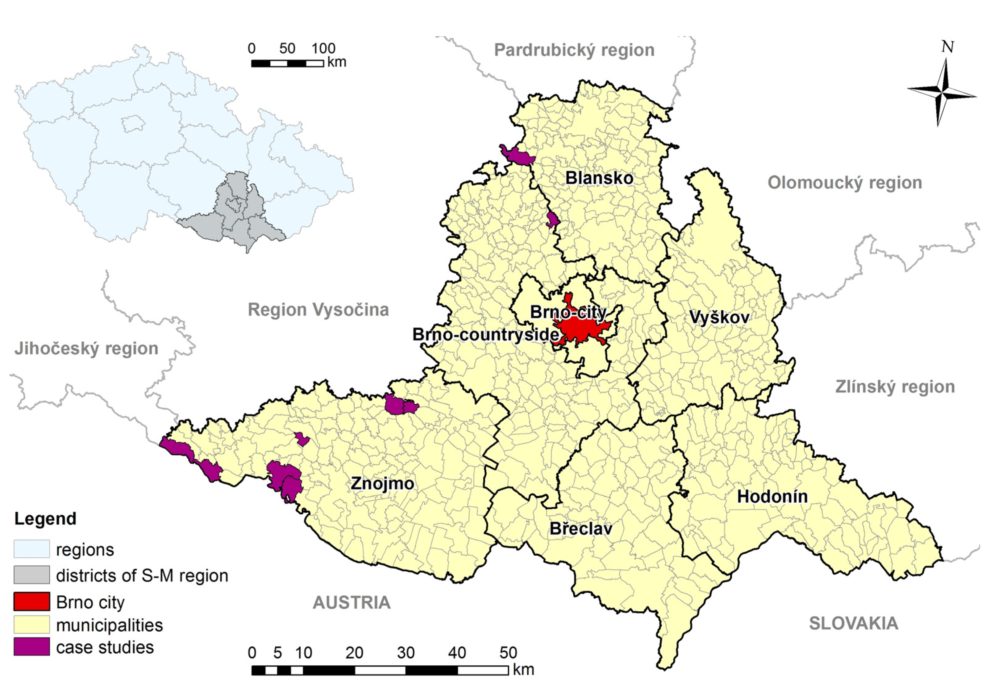
The largest concentration of villages with a bad accessibility of basic services can be found along the Moravian–Austrian border (Figure 4).

Figure 4.
Localization of the places from which the accessibility of basic services crosses a 29 min time distance, including walking time to and from the station. Source: own calculations. Drawn by J. Brychta.
The territory was a part of the Iron Curtain in the past. Its population was exchanged on an ethnic basis after WWII. Little attention was paid to the development of this area. The territory includes the villages Vratěnín (307 inhabitants; the accessibility of the police in the neighbouring Vysočina region is 34 min), Stálky (121 inhabitants; accessibility to Vranov nad Dyjí is within 34 min), Lukov (261 inhabitants; accessibility to Znojmo is possible within 37 min), Horní Břečkov (251 inhabitants; accessibility to Znojmo is within 38 min) and Čížov (part of Horní Břečkov, situated in Podyjí National Park; accessibility to Znojmo is within 45 min). Due to the borderland position, the villagers do not have any alternative commuting occasion. By commuting to Znojmo, the relatively long distance to the urban territory with slower traffic plays a role. The southwestern part of the South Moravian region along the Austrian border can be considered the only problematic area within the region.
There are some isolated cases in other districts, namely Černovice (population 377), in the micro-region of Boskovice, from which the central place—Lysice—is accessible within 35 min; Hluboké Dvory (population 87) in the micro-region of Tišnov, which is accessible within 30 min; and Uhřice (population 262) in the micro-region Bučovice, which is an isolated case.
6. Discussion
The results of our contribution are limited in that they assume that people satisfy their demand for services in the most accessible place. Several other factors can determine the quality of services, the connection with other services or activities in one place (usually with work), or the loyalty to a traditional service provider. Another limitation is the necessary averaging of indicators. Of course, waiting times or walking distances to transport stops may vary from case to case (for example, a railway station may be located eccentrically, and the walking speed of disabled people can be different). However, this cannot be distinguished on a regional scale. Possible traffic jams on roads caused by repairs, maintenance or road accidents were not taken into account. These problems are only temporary, and manifest themselves at different times on different sections of the roads.
An analysis of the accessibility of services of public interest in rural areas was made, for example, by Shin et al. [54]; Stentzel et al. [55] concluded that accessibility by public transport is not a question of distance but transport connections. In contradiction, our findings show that the organization of public transport, the frequency of connections and the continuity of lines is solvable at certain costs. However, the distances and physical transport conditions remain constant. People do not just choose services based on availability alone. They can also choose more distant services thanks to better quality (real or imagined), traditional links, and connections with other activities (jobs, higher-level services), etc.
The paradigm of cost-effectiveness and efficiency have become the dominant considerations for how the state is run at present. It becomes even more problematic in rural areas without a critical mass of customers (former citizens) and additional costs for transportation [56]. Such analyses are usually made for health-care services; again, usually for a narrow segment of medical care. On the other side, disappearing services not only mean worse accessibility but also a decrease of the rank and identity of the respective settlement. Local services are usually places where people meet and exchange information, creating a local community. A settlement without services becomes a mere dormitory or a place of the second housing.
The possibility to generalize or compare our findings with other regions is limited. The Integrated Transport System of the South-Moravian Region is also unique in the Czech conditions. One of the conditions is the existence of a concentric transport system within the region. In polycentric regions such as Vysočina, Karlovarský, Ústecký, Moravskoslezský and Zlínský, the creation of such a system would be more difficult. Another condition is transport accessibility as a regional, not a transport, problem. The paper serves more as an example of how to organize public transport in rural areas not only to reach regional centres but also for the interconnection of villages at a local level.
7. Conclusions
The answer to the main research question is: In the rural areas of the South Moravian Region, there are places where access to basic services reaches 30 min or more. This is true of 2.5% of the rural settlements in the region, in which 0.21% of the region’s population live. Their only concentration is located in the southwest of the region, on the borders between the regions of South Moravia, South Bohemia, Vysočina and Austria. It is a typical periphery, far from the regional centres of all regions as well as of the neighbouring country.
Another question asked whether an efficient public transport system capable of ensuring access to basic services of general interest can be organized, which can also be answered in the affirmative. However, this system cannot be built as an economically profitable, but rather as a social service. The invested public funds of regions and municipalities will be returned at a satisfactory level of rural development and at significantly lower costs of solving problems resulting from the risk of depopulation, unemployment and social exclusion.
It can be assumed that the good accessibility of services is one of the factors influencing the fact that the Moravian countryside as a whole is not threatened by depopulation [57]. All of the size categories of rural settlements in Moravia are currently experiencing migratory increases (usually at the expense of medium-sized cities). In the South Moravian Region, only the most remote villages in the far southwest are endangered by depopulation. Additionally, the unemployment rate in all Moravian towns exceeding 20,000 inhabitants, without any exception, is higher than the unemployment rate in their rural hinterlands.
The accessibility of services depends primarily on the characteristics of the settlement system (the size of the settlements and the distances between them) and the physical conditions of the transport (density of roads and railways, slope and direction conditions). Consequently, people who prefer living in small villages in peripheral mountain areas have to take into account the difficulties connected with the accessibility of basic services. It is one of the problems of the counterurbanization and naturbanization processes.
Concerning the suburbanized villages, the closeness to the city does not manifest any advantage in the accessibility of basic services because the time distance between the fringe of the city and its inner parts is extended, not to mention traffic jams. That is why, in suburbia, the presence of local basic services is extremely important.
The best accessibility of basic rural services is seen in the lowland regions with large villages which mostly have basic services or offer such services in neighbouring settlements, or even cooperate in the field of services. Additionally, the physical conditions for the transport are usually better, enabling fast and uncomplicated transport. Although the situation in the accessibility of basic services of public interest seems to be favourable, further termination of local services could be problematic. These cases should be confronted with a worsening of the accessibility of services in the settlement and the surrounding settlements, which can be threatened with a terminating of services. Even if the transport system operates efficiently, its additional loading is not advisable.
Brovarone and Cotella [58] speak about the multilayer approach to the solution of the accessibility of basic services in rural areas. It is more or less clear that it is not possible to leave it to market forces alone. In Southern Moravia, the way to support public transport has been chosen. The accessibility of basic services in a rural milieu depends on the existence of an integrated transport system, ensuring frequent connections between rural settlements and their local centres, and which is not oriented exclusively to the transport into big and medium-sized cities. Such a system should be created and operate as a public service—not so much as a subject of entrepreneurship—see mobility as a sevice concept [59]. Subsidies of regional and local authorities are necessary.
A general deepening of the trend of the disappearance of basic services from the rural area of the South Moravian Region is not expected, as rural revitalization is taking place. The numbers of inhabitants of rural municipalities are mostly increasing, and society is generally moving from manufacturing to services. However, the termination of services in individual municipalities for specific reasons cannot be excluded, which could cause the social exclusion of vulnerable groups of the population.
The solution may be partly to digitize some services. The measures taken with the Covid-19 pandemic in 2020 show that this is possible. E-communication, e-learning and e-recipes can be used as examples. There is no doubt that these trends will deepen concerning the smart village trends [60]. At the moment, the disadvantaged groups of people, especially seniors, are less friendly with internet use, and thus they were more excluded from services due to the pandemic [61]. However, they will also have to learn how to use them regularly. The computer literacy of the rural population is one of the ways to increase its education for practical purposes [62].
On the other hand, from a social point of view, long-term physical contact cannot be replaced by electronic communication. The digitization of services will play a similar role to the motorization of the population. The reduced frequency of physical contact with services that are being replaced digitally means that the number of passengers in public transport will be reduced; thus, it will result in the deepening of the vicious circle of public transport. In addition to integrated transport systems, integrated services are hypothetically possible in order to increase the number of potential customers above the critical limit and minimize operating costs. In earlier times, services in rural areas were combined with agricultural or other productive activities. This option mainly concerns commercial services. There are fewer such possibilities for highly specialized services of general interest, for example in health or education (for example, a doctor’s office and a pharmacy, or a school and library). However, this is probably hindered by a number of barriers of an administrative, organizational and psychological nature.
Therefore, much greater attention will have to be paid to the issues of community life in rural settlements. For example, Harmon and Schafft [63] highlight the role of schools in community development. However, other services like shops, pubs and post offices, etc., can play a similar role.
The territory of the region is covered by basic services quite evenly. Boruta and Ivan [64] came to similar conclusions in the Czech part of Silesia. If we wanted to look for regional differences, we would have to take into account services of a higher nature, such as secondary schools, health centres and financial institutions. However, these are no longer important for the community life of rural settlements, but rather for their central importance. While the accessibility of higher-order services (depending on high-speed roads and railways, and the distance from super-centres) affects the overall economic level of regions, their innovation potential, gross national product and other economic characteristics, the accessibility of local services directly affects the quality of life of local people, community life and social exclusion in localities. Therefore, this issue, which can be considered probably the most serious problem of European rural development in the post-Fordist period, should also be given increased attention in research. Our paper shows one example of good practice.
Further research could focus on the validity of the methodology and the assessment of the situation in other regions within Czechia and other European countries, respectively. An interesting topic could be the modelling of the impacts of various changes in the system (which cannot be ruled out) on the accessibility of services. From a sociological point of view, it could be beneficial to discover under which conditions passengers prefer public transport, and when they prefer an individual means of transport. Environmentalists could think about the ecological footprint of the countryside when using different modes of transport—it is known that the ecological footprint of the countryside compared to cities is worsened by commuting. The impact of the COVID 19 pandemic will be evaluated. However, one of the findings is that means of transport should not be overcrowded [65].
This methodology can be used for any European territory with an integrated transport system [66]. Such systems are especially usual in German-speaking countries [67]. In the case of a low connection frequency, this factor should also be taken into account. In the absence of an integrated transport system, the calculations would be significantly more complex and dependent on several other conditions.
It turns out that if the vicious circle of transport services in rural areas is to be overcome, public transport must not be understood as part of the pillar of economic sustainability, but of social sustainability or even environmental sustainability. Economic sustainability can be seen in the fact that support for inefficient public transport by public administrations will be returned in that there will be no need to invest in measures against unemployment, social exclusion and keeping social services in places where it is inefficient.
On a national scale, the availability of basic services in rural areas is the subject of the Regional Development Strategy 2021+. Our issues relate to the following strategic goals in economically and socially endangered regions (including the Znojmo and Hodonín districts in the South Moravian Region): ensuring transport services, providing social infrastructure, and preventing the emergence of socially excluded localities. The solution adopted by the South Moravian Region is implemented within the framework of transport policy. At the same time, the public transport system in the region significantly helps to achieve the above-mentioned regional development goals. It is also clear that transport services need to be addressed from a regional perspective, even if they are is a sectoral issue. If the transport policy were addressed from the point of view of transport interests, efficient transport would be ensured only in economically lucrative directions.
Author Contributions
Conceptualization, A.V.; Methodology, A.V.; Writing, A.V.; Original draft preparation, A.V.; Investigation, A.V.; Data curation, A.V.; Supervision, M.Š.; Writing, M.Š.; Reviewing and Editing, M.Š. Both authors have read and agreed to the published version of the manuscript.
Funding
This paper was elaborated as a particular analysis within the HORIZON 2020 project SPOT (Social and innovative Platform On cultural Tourism and its potential towards deepening Europeanisation), ID 870644, funding scheme Research and Innovation action, call H2020-SC6-TRANSFORMATIONS-2019, coordinated by the Mendel University in Brno.
Data Availability Statement
Data is available upon request.
Conflicts of Interest
The authors declare no conflict of interest.
References
- Thiede, B.C.; Brown, D.L.; Sanders, S.R.; Glasgow, N.; Kulcsar, L. A Demographic Deficit? Local Population Aging and Access to Services in Rural America, 1990–2010. Rural Sociol. 2017, 82, 44–74. [Google Scholar] [CrossRef] [PubMed] [Green Version]
- Panagiotopoulos, G.; Kaliampakos, D. Accessibility and Spatial Inequalities in Greece. Appl. Spat. Anal. Policy 2018, 12, 567–586. [Google Scholar] [CrossRef]
- Neumeier, S. Accessibility to Services in Rural Areas. disP Plan. Rev. 2016, 52, 32–49. [Google Scholar] [CrossRef]
- Kuliešis, G.; Pareigienė, L. Investigation of the demand of public services of rural areas. Manag. Theory Stud. Rural Bus. Infrastruct. Dev. 2015, 37, 521–531. [Google Scholar] [CrossRef] [Green Version]
- Kompil, M.; Jacobs-Crisioni, C.; Dijkstra, L.; Lavalle, C. Mapping accessibility to generic services in Europe: A market-potential based approach. Sustain. Cities Soc. 2019, 47, 101372. [Google Scholar] [CrossRef]
- Szczyrba, Z.; Fiedor, D.; Kunc, J. Služby ve venkovských regionech Česka—Kvantitativní hodnocení změn v up-lynulém transformačním období (příspěvek ke studiu venkova)/Services in rural regions of the Czech Republic—Quantitative assessment of changes in the past transformation period (contribution to rural studies). In XVI. Mezinárodní Kolokvium o Regionálních Vědách; Klímová, V., Žítek, V., Eds.; Masarykova Univerzita: Brno, Czech Republic, 2013; pp. 212–222. [Google Scholar]
- Lieszkovszky, J.P. Introduction to the theoretical analysis of social exclusion of public transport in rural areas. DETUROPE Cent. Eur. J. Rural Dev. Tour. 2018, 10, 214–227. [Google Scholar]
- Hubatková, B. Older adults’ well-being by the type of residential setting: The case of small municipalities in the Czech Republic. J. Rural Stud. 2019, 72, 196–204. [Google Scholar] [CrossRef]
- Lehtonen, O.; Muilu, T.; Vihinen, H. Multi-Local Living—An Opportunity for Rural Health Services in Finland? Eur. Countrys. 2019, 11, 257–280. [Google Scholar] [CrossRef] [Green Version]
- Berg, J.; Ihlström, J. The Importance of Public Transport for Mobility and Everyday Activities among Rural Residents. Soc. Sci. 2019, 8, 58. [Google Scholar] [CrossRef] [Green Version]
- Šipuš, D.; Abramovic, B. The Possibility of Using Public Transport in Rural Area. Procedia Eng. 2017, 192, 788–793. [Google Scholar] [CrossRef]
- Camarero, L.; Oliva, J. Thinking in rural gap: Mobility and social inequalities. Palgrave Commun. 2019, 5, 1–7. [Google Scholar] [CrossRef]
- Morkunas, M.; Labukas, P. The Evaluation of Negative Factors of Direct Payments under Common Agricultural Policy from a Viewpoint of Sustainability of Rural Regions of the New EU Member States: Evidence from Lithuania. Agriculture 2020, 10, 228. [Google Scholar] [CrossRef]
- Kluvankova, T.; Nijnik, M.; Spacek, M.; Sarkki, S.; Perlik, M.; Lukesch, R.; Melnykovych, M.; Valero, D.; Brnkalakova, S. Social Innovation for Sustainability Transformation and its Diverging Development Paths in Marginalised Rural Areas. Sociol. Rural. 2021, 61, 344–371. [Google Scholar] [CrossRef]
- Coderoni, S.; Pagliacci, F. The territorial dimension of environmental sustainability in Italy along the urban–rural continuum. J. Environ. Plan. Manag. 2017, 61, 1318–1339. [Google Scholar] [CrossRef]
- D’Souza, G.E.; Gebremedhin, T.G. Sustainability in Agricultural and Rural Development; Routledge: London, UK, 2019. [Google Scholar]
- Gallent, N.; Scott, M. Housing and sustainable rural development. In The Routledge Companion of Rural Planning (Not Paged); Scott, M., Gallent, N., Gkartzios, M., Eds.; Routledge: London, UK, 2018. [Google Scholar]
- Abramsson, M.; Hagberg, J.-E. What about community sustainability?—Dilemmas of ageing in shrinking semi-rural areas in Sweden. Scott. Geogr. J. 2018, 134, 103–121. [Google Scholar] [CrossRef] [Green Version]
- Morén-Alegret, R.; Fatorić, S.; Wladyka, D.; Mas-Palacios, A.; Fonseca, M.L. Challenges in achieving sustainability in Iberian rural areas and small towns: Exploring immigrant stakeholders’ perceptions in Alentejo, Portugal, and Empordà, Spain. J. Rural Stud. 2018, 64, 253–266. [Google Scholar] [CrossRef]
- Basile, G.; Cavallo, A. Rural Identity, Authenticity, and Sustainability in Italian Inner Areas. Sustainability 2020, 12, 1272. [Google Scholar] [CrossRef] [Green Version]
- Vasta, A.; Figueiredo, E.; Valente, S.; Vihinen, H.; Romero, M.N. Place-Based Policies for Sustainability and Rural Development: The Case of a Portuguese Village “Spun” in Traditional Linen. Soc. Sci. 2019, 8, 289. [Google Scholar] [CrossRef] [Green Version]
- McDaniels, B.W.; Harley, D.A.; Beach, D.T. Transportation, Accessibility, and Accommodation in Rural Communities. In Disability and Vocational Rehabilitation in Rural Settings; Springer Science and Business Media LLC: Berlin/Heidelberg, Germany, 2017; pp. 43–57. [Google Scholar]
- Mitrică, B.; Şerban, P.; Mocanu, I.; Grigorescu, I.; Damian, N.; Dumitraşcu, M. Social Development and Regional Disparities in the Rural Areas of Romania: Focus on the Social Disadvantaged Areas. Soc. Indic. Res. 2020, 152, 67–89. [Google Scholar] [CrossRef]
- Christaller, W. Die Zentralen Orte in Süddeutschland; Gustav Fischer: Jena, Germany, 1933. [Google Scholar]
- Spengler, J.J.; Lösch, A. Die raumliche Ordnung der Wirtschaft. South. Econ. J. 1941, 7, 578. [Google Scholar] [CrossRef]
- Vionis, A.K.; Papantoniou, G. Central Place Theory Reloaded and Revised: Political Economy and Landscape Dynamics in the Longue Durée. Land 2019, 8, 36. [Google Scholar] [CrossRef] [Green Version]
- Heffner, K.; Twardzik, M. The Impact Of Shopping Centers In Rural Areas And Small Towns In The Outer Metropolitan Zone (The Example Of The Silesian Voivodeship). Eur. Countrys. 2015, 7, 87–100. [Google Scholar] [CrossRef] [Green Version]
- Hodge, H.; Carson, D.; Carson, D.; Newman, L.; Garrett, J. Using Internet technologies in rural communities to access services: The views of older people and service providers. J. Rural Stud. 2017, 54, 469–478. [Google Scholar] [CrossRef]
- Vaishar, A.; Šťastná, M.; Stonawská, K. Small Towns—Engines of Rural Development in the South-Moravian Region (Czechia): An Analysis of the Demographic Development. Acta Univ. Agric. Silvic. Mendel. Brun. 2015, 63, 1395–1405. [Google Scholar] [CrossRef] [Green Version]
- Vaishar, A.; Zapletalová, J. Small towns as centres of rural micro-regions. Eur. Countrys. 2009, 1, 70–81. [Google Scholar] [CrossRef]
- Kašparová, L.; Půček, M. Cohesion Policy: Settlement in the Czech Republic; Ministry of Regional Development of the Czech Republic: Praha, Czech Republic, 2009.
- Glasmeier, A.; Howland, M. Service-Led Rural Development: Definitions, Theories, and Empirical Evidence. Int. Reg. Sci. Rev. 1993, 16, 197–229. [Google Scholar] [CrossRef]
- Moseley, M.J. Accessibility: The Rural Challenge; Methuen and Company Ltd.: London, UK, 1979. [Google Scholar]
- Joseph, A.E.; Bantock, P.R. Measuring potential physical accessibility to general practitioners in rural areas: A method and case study. Soc. Sci. Med. 1982, 16, 85–90. [Google Scholar] [CrossRef]
- McGrail, M.R.; Humphreys, J.S. Measuring spatial accessibility to primary care in rural areas: Improving the effectiveness of the two-step floating catchment area method. Appl. Geogr. 2009, 29, 533–541. [Google Scholar] [CrossRef]
- Shah, T.I.; Milosavljevic, S.; Bath, B. Measuring geographical accessibility to rural and remote health care services: Challenges and considerations. Spat. Spatio Temporal Epidemiol. 2017, 21, 87–96. [Google Scholar] [CrossRef]
- Marques, J.L.; Wolf, J.; Feitosa, F. Accessibility to primary schools in Portugal: A case of spatial inequity? Reg. Sci. Policy Pract. 2021, 13, 693–707. [Google Scholar] [CrossRef]
- Stassen, R.; Ceccato, V. Police Accessibility in Sweden: An Analysis of the Spatial Arrangement of Police Services. Polic. J. Policy Pract. 2019, 068. [Google Scholar] [CrossRef] [Green Version]
- Augustyn, D. The Influence of Public Transport Acts in 2019 in Poland on Conflicts Concerning the Shape of the Public Transport Network. Logist. Transp. 2020, 45–46, 59–69. [Google Scholar] [CrossRef]
- Peacock, A.; Pemberton, S. The paradox of mobility for older people in the rural-urban fringe. J. Rural Stud. 2019, 70, 9–18. [Google Scholar] [CrossRef]
- Papangelis, K.; Velaga, N.R.; Ashmore, F.; Sripada, S.; Nelson, J.; Beecroft, M. Exploring the rural passenger experience, information needs and decision making during public transport disruption. Res. Transp. Bus. Manag. 2016, 18, 57–69. [Google Scholar] [CrossRef]
- Nagendra, R.V.; Nelson, J.; Steve, D.W.; John, H.F. The Potential Role of Flexible Transport Services in Enhancing Rural Public Transport Provision. J. Public Transp. 2012, 15, 111–131. [Google Scholar] [CrossRef]
- Geurs, K.T.; La Paix, L.; Van Weperen, S. A multi-modal network approach to model public transport accessibility impacts of bicycle-train integration policies. Eur. Transp. Res. Rev. 2016, 8, 25. [Google Scholar] [CrossRef] [Green Version]
- Porru, S.; Missoa, F.E.; Pani, F.E.; Repetto, C. Smart mobility and public transport: Opportunities and challenges in rural and urban areas. J. Traffic Transp. Eng. Engl. Ed. 2020, 7, 88–97. [Google Scholar] [CrossRef]
- Mounce, R.; Wright, S.; Emele, C.D.; Zeng, C.; Nelson, J. A tool to aid redesign of flexible transport services to increase efficiency in rural transport service provision. J. Intell. Transp. Syst. 2018, 22, 175–185. [Google Scholar] [CrossRef] [Green Version]
- Geurs, K.T.; Van Wee, B.; Rietveld, P. Accessibility appraisal of integrated land-use—Transport strategies: Methodology and case study for the Netherlands Randstad area. Environ. Plan. B Plan. Des. 2006, 33, 639–660. [Google Scholar] [CrossRef] [Green Version]
- Guzman, L.A.; Oviedo, D.; Cardona, R. Accessibility Changes: Analysis of the Integrated Public Transport System of Bogotá. Sustainability 2018, 10, 3958. [Google Scholar] [CrossRef] [Green Version]
- Rosik, P.; Pomianowski, W.; Komornicki, T.; Goliszek, S.; Szejgiec-Kolenda, B.; Duma, P. Regional dispersion of potential accessibility quotient at the intra-European and intranational level. Core-periphery pattern, discontinuity belts and distance decay tornado effect. J. Transp. Geogr. 2020, 82, 102554. [Google Scholar] [CrossRef]
- Kerkman, K.; Martens, K.; Meurs, H. A multilevel spatial interaction model of transit flows incorporating spatial and network autocorrelation. J. Transp. Geogr. 2017, 60, 155–166. [Google Scholar] [CrossRef]
- Šťastná, M.; Vaishar, A. The relationship between public transport and the progressive development of rural areas. Land Use Policy 2017, 67, 107–114. [Google Scholar] [CrossRef]
- Vaishar, A.; Šťastná, M.; Vavrouchová, H.; Stejskal, B.; Hlisnikovský, L.; Jakešová, L.; Kniezková, T.; Kozáková, H.; Lipovská, Z.; Marciánová, G.; et al. Současný Stav a Vývojové Tendence Ji-Homoravského Venkova; Mendel University: Brno, Czech Republic, 2011. [Google Scholar]
- Sörensen, L.; Bossert, A.; Jokinen, J.-P.; Schlüter, J. How much flexibility does rural public transport need?—Implications from a fully flexible DRT system. Transp. Policy 2021, 100, 5–20. [Google Scholar] [CrossRef]
- Kučerová, S.; Kučera, Z. Changes in the rural elementary schools network in Czechia during the second half of the 20th century and its possible impact on rural areas. Eur. Countrys. 2009, 1, 125–140. [Google Scholar] [CrossRef] [Green Version]
- Shin, M.; Park, M.; Jeon, J.; Park, R.; Kim, S. Analysis of Accessibility of Public interest related Living Service in Rural Area. J. Korean Soc. Rural Plan. 2019, 25, 19–27. [Google Scholar] [CrossRef]
- Stentzel, U.; Piegsa, J.; Fredrich, D.; Hoffmann, W.; Berg, N.V.D. Accessibility of general practitioners and selected specialist physicians by car and by public transport in a rural region of Germany. BMC Health Serv. Res. 2016, 16, 1–10. [Google Scholar] [CrossRef] [Green Version]
- Assmo, P.; Wihlborg, E. Public Services Choices When There Are No Alternatives?—A Paradox of New Public Management in Rural Areas. J. Rural Community Dev. 2012, 7, 1–17. [Google Scholar]
- Vaishar, A.; Šťastná, M.; Zapletalová, J.; Nováková, E. Is the European countryside depopulating? Case study Moravia. J. Rural Stud. 2020, 80, 567–577. [Google Scholar] [CrossRef]
- Brovarone, E.V.; Cotella, G. Improving Rural Accessibility: A Multilayer Approach. Sustainability 2020, 12, 2876. [Google Scholar] [CrossRef] [Green Version]
- Eckhardt, J.; Nykänen, L.; Aapaoja, A.; Niemi, P. MaaS in rural areas—Case Finland. Res. Transp. Bus. Manag. 2018, 27, 75–83. [Google Scholar] [CrossRef]
- Zavratnik, V.; Kos, A.; Duh, E.S. Smart Villages: Comprehensive Review of Initiatives and Practices. Sustainability 2018, 10, 2559. [Google Scholar] [CrossRef] [Green Version]
- Saunders, E.J. Maximizing Computer Use among the Elderly in Rural Senior Centers. Educ. Gerontol. 2004, 30, 573–585. [Google Scholar] [CrossRef]
- Seifert, A. The Digital Exclusion of Older Adults during the COVID-19 Pandemic. J. Gerontol. Soc. Work. 2020, 63, 674–676. [Google Scholar] [CrossRef] [PubMed]
- Harmon, H.L.; Schafft, K. Rural School Leadership for Collaborative Community Development. Rural Educ. 2018, 30. [Google Scholar] [CrossRef]
- Boruta, T.; Ivan, I. Public transport in rural areas of the Czech Republic—Case study of the Jeseník region. Morav. Geogr. Rep. 2010, 18, 9–22. [Google Scholar]
- Patlins, A. Adapting The Public Transport System to the COVID-19 Challenge, Ensuring its Sustainability. Transp. Res. Procedia 2021, 55, 1398–1406. [Google Scholar] [CrossRef]
- Givoni, M.; Banister, D. Integrated Transport System: From Policy to Practice; Routledge: London, UK, 2010. [Google Scholar]
- Buehler, R.; Pucher, J.; Dümmler, O. Verkehrsverbund: The evolution and spread of fully integrated regional public transport in Germany, Austria, and Switzerland. Int. J. Sustain. Transp. 2019, 13, 36–50. [Google Scholar] [CrossRef]

Publisher’s Note: MDPI stays neutral with regard to jurisdictional claims in published maps and institutional affiliations. |
© 2021 by the authors. Licensee MDPI, Basel, Switzerland. This article is an open access article distributed under the terms and conditions of the Creative Commons Attribution (CC BY) license (https://creativecommons.org/licenses/by/4.0/).