Abstract
Climate change is unequivocal. Farmers are increasingly vulnerable to floods and drought. In this article, the negative impact of climate hazards on rice cultivation in the Tonle Sap and Mekong River influenced by climatic variability between 1994 and 2018 are analyzed. A cohort of 536 households from four Cambodian districts participated in household surveys designed to consider how various vulnerability factors interacted across this time series. It was found that: (i) The major climate hazards affecting rice production between 1994 and 2018 were frequent and extreme flood and drought events caused by rainfall variability; (ii) In 2018, extreme flood and drought occurred in the same rice cultivation cycle. The impact caused by each hazard across each region were similar; (iii) An empirical model was used to demonstrate that drought events tend to limit access to irrigation, impact rice production, and result in an increased prevalence of water-borne diseases. Flood events cause reduced rice production, damage to housing, and impede children from accessing education. The impact of drought events on rice production was found to be more severe than flood events; however, each climatic hazard caused physical, economic, social, and environmental vulnerabilities. It is recommended that sufficient human and financial resources are distributed to local authorities to implement adaptation measures that prepare rice farmers for flood and drought events and promote equitable access to water resources.
1. Introduction
Climate change has significant impacts on Cambodian rice producers [1] as a result of variations in rainfall patterns [2]. Since the 1960s, atmospheric CO2 concentrations have increased by 21%, causing a higher number of hot days and nights each season [3] and an average annual temperature increase of +0.8 °C [4]. Wet season rainfall has increased over time, resulting in more frequent flood events. Meanwhile precipitation in the dry season has remained stable, possibly decreasing [5]. A flood pulse is a dominant characteristic of hydrology of the Tonle Sap and Mekong River [6], which is influenced by the El Niño Southern Oscillation (ENSO) (which causes inter-annual variations, bringing warmer, drier winters in El Niño years and cooler than average summers in La Niña years) [7,8]. Climate change impacts in Cambodia manifest as flood and drought events that severely impact socio-economic development [9]. The country is highly vulnerable to these events due to insufficient infrastructures [10], low adaptive capacity [11], and a high dependence on natural resources [12].
Agriculture is the backbone of the Cambodian economy and an essential source of income for many of the 78% of citizens who live rurally [13] and have livelihoods that are dependent on agriculture [5,14]. For instance, in 2017 agriculture employed 37% of the total population [15] and contributed 16.3% of GDP in 2018 [16]. Rice-based farming systems have dominated the landscape for more than 2000 years [17]. Cambodia currently exports between four and five million metric tons of rice, with production growing at 3.8% per annum [18]. In 2018, Cambodia produced up to 10.8 million metric tons, with rice accounting for around half of agricultural GDP. Three-quarters of the rice was produced in flooded wetlands of the Tonle Sap and Mekong River [19]. A high proportion of the rural population of Cambodia live within 15 km of these wetlands and the sustainability of rice-based livelihoods [20,21] are highly sensitive to variations in the flood pulse dynamics of the river system [22].
The Climate Change Action Plan (2016–2018) of the Royal Government of Cambodia (RGoC) recognizes this, identifying agriculture as one of the most climate-sensitive sectors in the country due to impacts on rain-fed rice production systems [23,24] and fisheries [25]. Devastating flood events have been a common occurrence in Cambodia since 1999, while drought events began to cause concern in 2003 [26]. Both hazards have significantly impacted rice production. For instance, a drought in 2004 reduced projected rice production by 82%, while the 2011 floods affected 1.5 million people in 18 out of the 25 provinces in Cambodia and damaged around 17% of crops [27]. These were not isolated events. Between 2000 and 2002, Cambodia suffered from a series of severe flood events [28]. The RGoC spent 12 million USD recovering from a major drought in 2009 [29]. The 2011 floods were coupled with a major drought, affecting 3804 hectares in 2011 and 14,190 hectares in 2012, of which 3151 hectares were destroyed [30]. Less extensive droughts also impacted local rice production in 1999, 2000, 2008, and 2012 [31].
Drought and flood events are expected to become more frequent and intense. An investigation into the impacts of climate change on rice cultivation systems is important for informing adaptation measures that may reduce the vulnerability of rice farmers in Cambodia. Thus, three research questions were framed to guide this research: (i) How has the climate changed in Cambodia over the past 30 years? (ii) To what extent do climate hazards produce vulnerabilities among rice farmers? Lastly, (iii) what physical, economic, social, and environmental factors influence how vulnerabilities due to climate hazards are experienced? This paper not only uses the four vulnerability factors defined by the United Nations (UN) in 2004 to discuss the core issues but also focuses on practical implications and experience to enhance the development agenda in the specific contexts of the Tonle Sap or Mekong River.
2. Conceptualizing Interaction of Vulnerability Factors to Climate Change
The agriculture sector is one of the most vulnerable to climate change in Cambodia [32]. Climate change has resulted in decreased food production [33], posing threats to the socio-economic development of rice farmers [34]. This is linked to proven negative impacts, that increase the risks associated with rice cultivation [35]. Higher temperatures [36] and changes to rainfall distribution increase the frequency and intensity of extreme weather events [37], such as floods [38] and drought [39]. This has caused a marked decrease in rice production [40], with even minor increases in temperature having a significant impact [41]. For instance, in the Philippines, a 1 °C increase in the mean temperature of a growing season has been shown to decrease dry season rice yields by 15% [42]. A similar rice yield reduction of 18% due to alterations in precipitation cycles and temperatures has been recorded in Thailand [43]. In Cambodia, climate change impacts have witnessed a gradual increase and eventually reached a stage beyond the adaptive capacity of rice farmers.
The relationship between climate change impacts and rice cultivation has been investigated with respect to vulnerabilities and adaptation. Some researchers have focused on impacts such as: investigating the direct effects of climate change on rice yields in China [44]; mapping regional climate risks on rainfed rice in India [45]; managing climate risks and opportunities for rice production in the West-African floodplains [46]; and livelihood constraints of rice farmers in Indonesia [47]. Meanwhile, others have focused on technological innovations, such as enhancing rice productivity in Nepal [48] or climate change adaptation in the agricultural sector in Sri Lanka [49].
Over the last two decades, vulnerability frameworks have been increasingly used to understand the impacts of climate change [50,51]. A range of tools have been developed to identify vulnerability at the household or community level. For example, multi-criteria decision analysis has been used to classify vulnerability at the household level in Mexico [52]; a social vulnerability index has been used to assess vulnerability across different countries in Africa [53]; and vulnerability indicators have been used to map vulnerability hot spots in India [54]. Vulnerability indicators have the advantage of being able to be used for self-assessment that empowers local communities to determine potential losses and damage of life and economic activities from climatic hazards [55].
Vulnerability has been defined as an indirectly observable phenomenon, where outcomes can only be studied after adaptation has occurred [56]. Interest in vulnerability as a link between disasters and development grew during the 1980s and 1990s and was later extended to socio-economic and environmental concerns. In 2004, the United Nations distinguished between four types of vulnerability (see Table 1) in the context of risk assessment and disaster risk management, including physical, economic, social, and environmental factors [57]. While researchers use multi-criteria decision and social vulnerability index for formulating decision matrix and social impacts, vulnerability indicators and four vulnerability types are being conducted to assess the negative effects of climate change based on sustainability perspective.

Table 1.
Conceptualizing an interaction of vulnerability factors.
However, vulnerability may be defined differently depending on the methodology used for evaluation [58]. For instance, some frameworks use indicators of risk experienced by different classes of society [59], the potential for loss [60], or measures of potential future harm due to an inability to withstand the effects of a hostile environment [61,62]. Scholars have also categorized vulnerability into natural [63] vs. social forms [64], as well as vulnerability caused by internal [65] vs. external factors [66]. Another review paper on the assessment of strengths and weaknesses of different groups to climate change identified biophysical, human ecological, political economy, constructivist, and political ecology perspectives on human vulnerability [67]. Physical-environmental, socio-economic, and external dimensions have of vulnerability have also been defined in this context [68].
This research applies the four vulnerability factors defined by the UN in 2004 [57] to climate change impacts on rice cultivation at the household level rice cultivation (Table 1). It gathers empirical evidence of climate change vulnerability focused on flood and drought events. These two hazards are well articulated in disaster risk management literature but there is a scarce discussion of how well physical data aligns with qualitative information on climate change vulnerability in the Cambodian context. The four vulnerability factors are well suited to providing a better understanding of how climate change affects rice cultivation because this concept covers all the aspects of sustainability.
The existing literature on the vulnerability of rice producers to climate change in the country has focused on: environmental changes [69], socio-economic issues [70,71,72], and adaptation and resilience strategies [73,74,75,76,77,78,79,80]. An additional study makes predictions about the impacts of climate change on agriculture to 2050 [81]. Climate change has affected water productivity [74] and negatively impacted rice yields of small farmers [75]. In Tonle Sap Lake, climate change caused long-term challenges to farmers’ livelihoods due to weak adaptive capacity [76]. As a result, adaptation and resilience are important for coping with social and economic vulnerability [80]. In reducing the negative impacts of climate change, Sok and Yu (2015) linked adaptation, resilience, and sustainable livelihood to identify vulnerabilities in the Mekong River; they recognize roles of the five assets, support mechanism, and livelihoods strategies [77].
Overall, these existing studies focus on the impacts of climate change and how they are responded to using local adaptive capacity, indigenous knowledge, and external support in either the Tonle Sap or Mekong River. The impact of climate variability on rice cultivation in the Tonle Sap and Mekong River between 1994 and 2018 is assessed in this study, including how different vulnerabilities to flooding and drought interact in these areas. The present study is the first to compare climate change impacts and adaptation across these two regions. It is also the first to conduct an empirical and theoretical analysis of the vulnerability of rice farmers to climate change at the district level in Cambodia.
3. Materials and Methods
A range of primary and secondary data was collected to enable an analysis of the impacts of climate change on cultivated areas of rice paddies in the Tonle Sap and the Mekong River. Secondary raw rainfall data over areas cultivated with rice paddies was sourced from the Ministry of Water Resources and the Meteorology (MoWRaM) and the Ministry of Agriculture, Forestry and Fisheries (MAFF) for the period between 1994 and 2018. This was used to generate results for a Standardized Precipitation Index (SPI) and develop climate vulnerability maps for each region. This enabled monthly rainfall data to be used to specify significant flood and drought periods, which were then linked to qualitative information on the perception of residents about changes to the frequency and intensity of flood and drought events over these periods.
Primary data was collected via household surveys, along with key informant interviews and group discussions conducted as part of the fieldwork conducted between May 2019 and March 2020. Four districts representative of the overall conditions in each target province were selected for these research activities, based on their level of dependence on water resources for rice paddy cultivation and vulnerability to the impacts of climate change. The selection was informed by discussions with local stakeholders such as government officers and NGO representatives from the four provinces. This provided an opportunity to compare the impacts of climate change across different rice-producing regions. Bakan and Sangke districts in Pursat and Battambang province, respectively, were chosen to represent the Tonle Sap Region, while Peam Ro and Kompong Siem districts in Prey Veng Kompong Cham Provinces, respectively, were chosen to represent the Mekong River region (Figure 1).
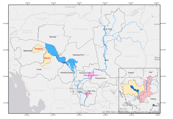
Figure 1.
Map of Cambodia highlighting the four study districts.
A total of 536 rice farming households were systematically sampled for the survey: 127 in Bakan, 136 in Sangke, 144 in Peam Ro, and 129 in Kompong Siem (Yamane, 1967) [82]. The survey collected data on local perceptions about the impacts of climatic change related to various environmental, economic, and social vulnerability factors. A structured questionnaire was used to elaborate on local perceptions of climatic change, including the degree to which local rice farmers were affected by flood and drought events, and their degree of social, economic, physical, and environmental vulnerability. Further interviews were conducted with government officials, NGOs, and local authorities to obtain their insights into the impacts of climate change on rice production. The interviews were conducted after preliminary findings from the survey were available. Questions were used to clarify and elaborate on key findings from the survey.
Following the interviews, focus group discussions comprising 10 participants were held with rice farmers and the commune heads of each district. The meetings were used to discuss problems that had arisen due to climate change impacts. A meeting of local experts in the fields of physical and human geography, environmental and social sciences, and development studies, also comprising 10 participants was conducted to access a local analysis of the survey data. A full list of interviewees and focus-group discussions is attached in Appendix A. The researchers also participated in various regional conferences to gain insights into the impact of climate change on rice production across the region including the 8th Regional Stakeholder Forum held in Bangkok, Thailand (5–6 November 2019), and the 9th Regional Stakeholder Forum held in Lang Prabang, Lao PDR (5–6 February 2020).The Standardized Precipitation Index (SPI) applied as part of this study was used to compare the probability of precipitation across different time scales in the region using precipitation data accessed from MoWRaM. By definition, the Standardized Precipitation Index (SPI) is a measurement of rainfall intensity for a certain time scale such as 1, 2, or more months. It was introduced by McKee McKee, Doesken, and Kleist (1993) [83] based on the probability distribution illustrated by Thom (1966) [84]. Climate vulnerability maps were developed using annual rainfall data and provincial statistics on the area of crops damaged by flood and drought accessed from MAFF. The rainfall gradient displayed on the maps was determined using the Inverse Distance Weight method.
The survey data were analyzed using Weight Average Index (WAI), t-tests, ANOVA, and logistic regression. WAI measuring on a five-point scale was used to draw local perceptions regarding climatic change and the interaction of vulnerability factors incurred by flood and droughts. The five-point scale included: considerably less (CL) = 0.00–0.20, less (L) = 0.21–0.40, moderate (M) = 0.41–0.60, high (H) = 0.61–0.80, and very high (VH) = 0.81–1.00. While the T-test was used to compare mean values of vulnerability factors across the Tonle Sap and the Mekong River regions, ANOVA was applied to compare the mean values within the four study districts. Attributes used for analysis, t-test and ANOVA included increasing temperatures, reduced availability of water resources, decreasing soil moisture, decreasing mangrove cover and river levels, and an increased occurrence of windstorms and lightning. Simultaneous Multiple Regression was used to predict whether these values were significant with respect to climate impacts related to flood and drought events. The key informant discussions were used to elaborate on the information obtained about various physical, economic, social, and environmental vulnerability factors, which were analyzed with respect to the survey data during the focus groups involving local experts.
4. Results
4.1. Climate Variability between 1994 and 2018
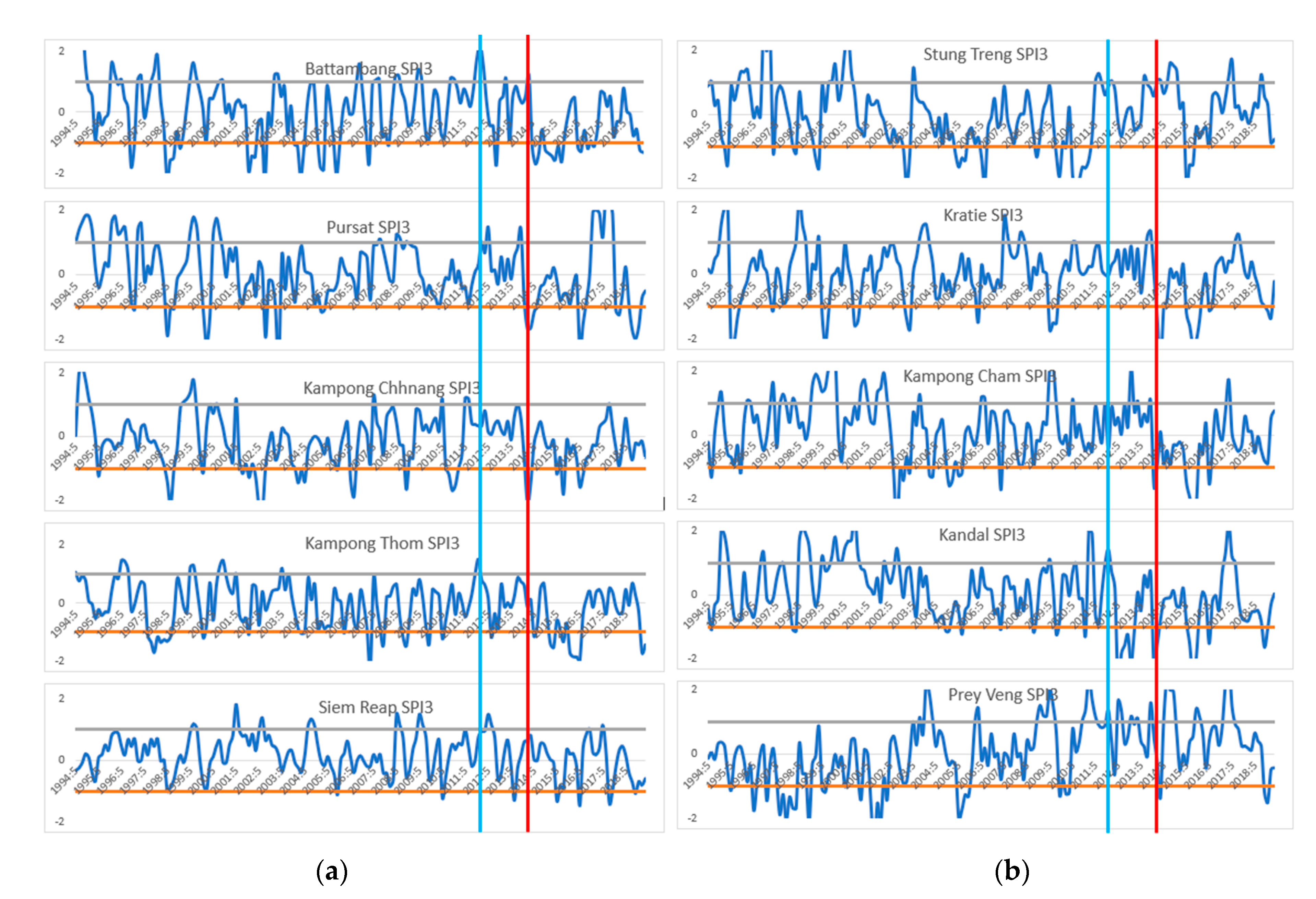
Figure 2a,b compare the results of the SPI using a 3-month moving average (SPI3) for rainfall between 1994 and 2018 in the Tonle Sap and the Mekong River. The results show that between 1994 and 2018, climate variabilities brought different threats to the Tonle Sap and Mekong River mainly flood and drought. The Tonle Sap was more vulnerable to drought, while the Mekong River tended to be more flood-affected. In the Tonle Sap, drought was the major threat to this region. The blue and red lines intersecting the SPI3 time series are used to highlight the period between 2012 and 2014, where severe flood and drought events occurred across the country. Figure 2b, which displays results for the Tonle Sap region, show that Battambang and Siem Reap were affected by flood and drought during this period, while the three other provinces were affected only by floods. While an ENSO pattern occurred across the entire period (1994–2018) in the Tonle Sap, the drought that occurred in 2015 and 2016 was a once-in-a-lifetime event. All provinces in the Tonle Sap recorded similar rainfall patterns and the drought was experienced across the entire regime.
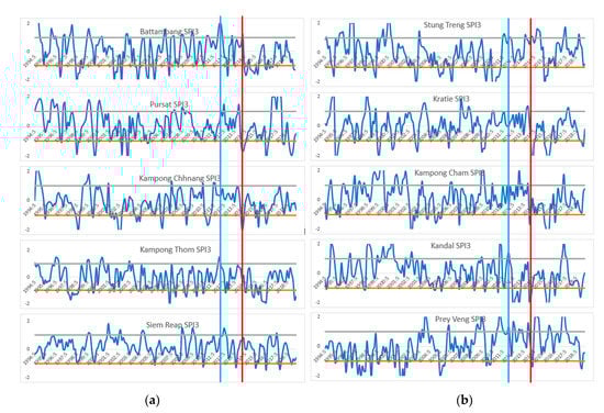
Figure 2.
(a) SPI3 in the Mekong River region. (b) SPI3 in the Tonle Sap region.
In the Mekong region, flood and drought events were experienced at different intensities between 1994 and 2018 across each province. For instance, while Kampong Cham and Prey Veng provinces were affected by flooding between 2012 and 2013, Kandal was in drought. Even though Prey Veng and Kandal are adjacent to each other in the Mekong River region, the latter experienced climatic conditions consistent with those in Siem Reap in the Tonle Sap at this time. Rice production under normal climatic conditions would be expected to vary with precipitation across the two regions, where one receives sufficient rainfall for rice cultivation, while the other may be affected by flood or drought. For example, in 2014, while Stung Treng was affected by a minor drought, Kampong Chhnang was impacted more severely. Thus, in the presence of a strong regional climatic driver such as El Niño affecting rainfall, drought would be expected to be experienced at different degrees of severity across the country. (When SPI is positive and more than 1; it is flood. When it is negative and more than 1, it is drought. The higher the number SPI is, the more severe the flood or drought event.)
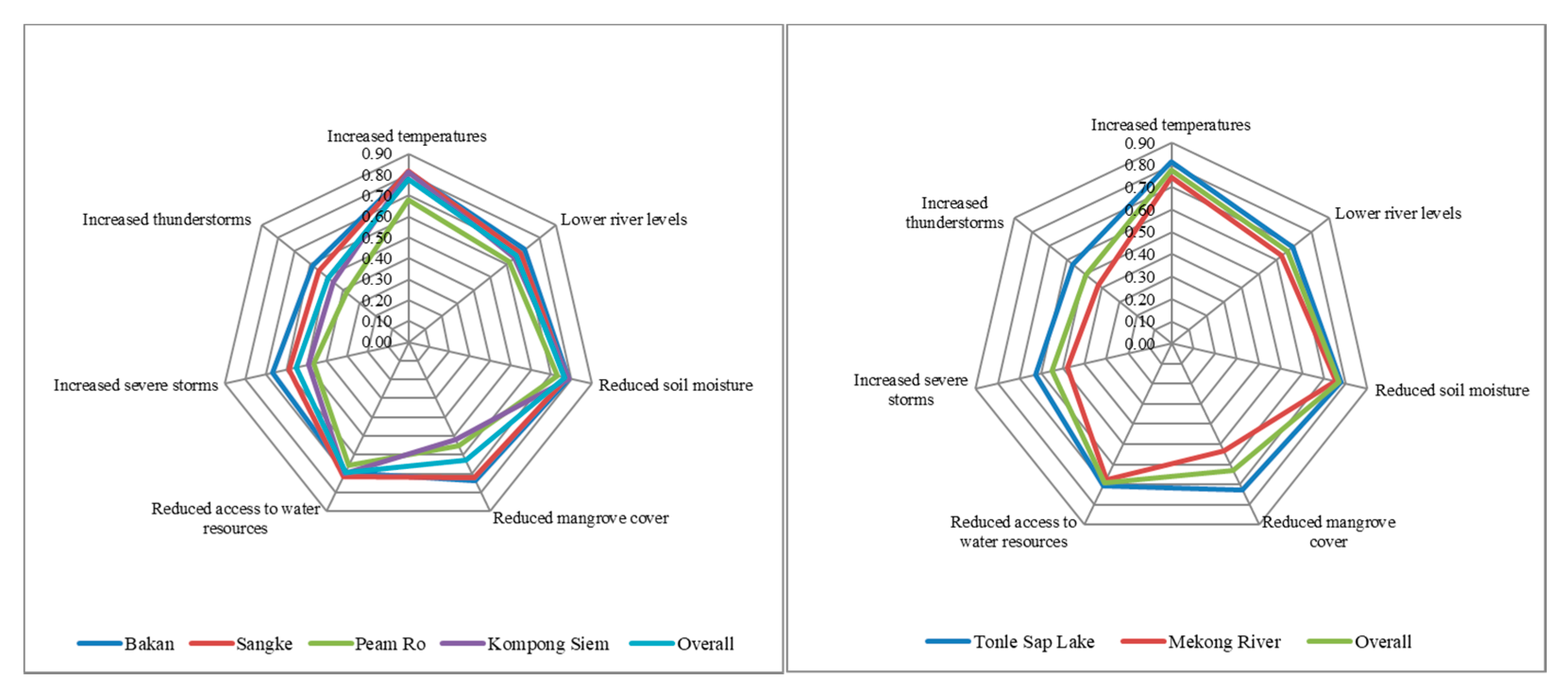
The survey results provide an indication of the local perceptions of rice farmers about the degree of climatic change, including increasing temperatures, reduced availability of water resources, decreasing soil moisture, decreasing mangrove cover and river levels, and an increased occurrence of windstorms and lightning (Figure 3). Rice farmers in the Tonle Sap indicated a high level of concern over several indicators of climate change impacts, including increased temperatures (WAI = 0.78), reduced soil moisture (WAI = 0.77), lower river levels (WAI = 0.69), reduced access to water resources (WAI = 0.66), and reduced mangrove cover (WAI = 0.63); and a moderate degree of concern about changes to the frequency of windstorms (WAI = 0.55) and lightning (WAI = 0.49).
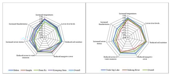
Figure 3.
Local perceptions towards key attributes of climatic change in the past 30 years in the Tonle Sap and the Mekong River. Note: WAI = Weight Average Index measured on a five-point scale (Considerably Less (CL) = 0.00–0.20, Less (L) = 0.21–0.40, Moderate (M) = 0.41–0.60, High (H) = 0.61–0.80, Very High (VH) = 0.81–1.00); OA = Overall Assessment; p-value for ANOVA test among the stud area: Increased temperatures = 0.000, Reduced access to water resources = 0.000, Reduced soil moisture = 0.000, Reduced mangrove cover = 0.000, Lower river levels = 0.002, Increased severe storms = 0.000, Increased thunderstorms (leading to death) = 0.000. p-value for T-test comparing the Tonle Sap Lake region with the Mekong River region: Increased temperatures = 0.000, Reduced access to water resources = 0.000, Reduced soil moisture = 0.009, Reduced mangrove cover = 0.000, Lower river levels = 0.0019, Increased severe storms = 0.000, Increased thunderstorms (leading to death) = 0.000.
Recently, climate change impacts have caused a shift in rainfall patterns tending towards drought and high temperatures, water scarcity, and low soil moisture and river levels. Coping strategies in the Tonle Sap have resulted in a significant decline in flooded forest cover as residents have lit fires to clear these resources across both regions to increase access to agricultural land. At the same time, climate impacts such as windstorms and lightning have become more extreme, resulting in an increased number of deaths [Expert-FG].
The ANOVA confirms that the perspectives of rice farmers about climate change impacts over the last 30 years, across each of the four study districts, varied considerably. For instance, rice farmers in Peam Ro demonstrated a high degree of concern about increased temperatures, while this was very high for the other three districts (p-value = 0.000). Rice farmers in Bakan indicated a high degree of concern about reduced access to water resources (p-value = 0.000) windstorms (p-value = 0.000) and lightning (p-value = 0.000). Rice farmers in Peam Ro also indicated a low degree of concern about reduced soil moisture (p-value = 0.000), while rice farmers in Bakan and Sangke indicated a high degree of concern about changes to mangrove cover, whereas this concern was only moderate in the other two provinces (WAI = 0.000). Rice farmers in Sangke and Kompong Siem shared a high degree of concern about a reduction in river levels (p-value = 0.002). The commune heads of Bakan observed that rice farmers in the Tonle Sap faced difficulties both in terms of there being too much water, as well as water scarcity as paddy rice production was impacted by variable rainfall patterns [FGD–1]. In the Mekong River region, rice farmers lacked a well-functioning irrigation system to supply sufficient water for dry-season rice cultivation. However, in Peam Ro many farmers were required to apply this strategy as paddy fields were covered by floods during the entire wet season [FGD–2].
4.2. Negative Impacts of Climate Hazards on Rice Paddy Cultivation
During a typical year, the monsoon season starts in late May and ends in October. Local experts indicate that the heavy rain received between September and October is the most significant for traditional rice cultivation, as it provides water to stimulate flowering of the rice plant, while also suppressing weeds [Expert-FG]. In 2018, climatic conditions fluctuated between flood and drought throughout the country within the same growing season (June and November). Figure 4 demonstrates that during this time 58,565 hectares were destroyed by drought, while 54,072 hectares were destroyed by flood (p-value = 0.190). A tropical depression developed over Cambodia in mid-July 2018 resulting in extremely high rainfall, with events affecting several provinces in each region. Meanwhile, rainfall peaks that usually occurred in September and October did not eventuate, leading to drought. The impacts of this variability in rainfall patterns worsened at the end of the season when many wetlands rapidly evaporated [Expert-FG].
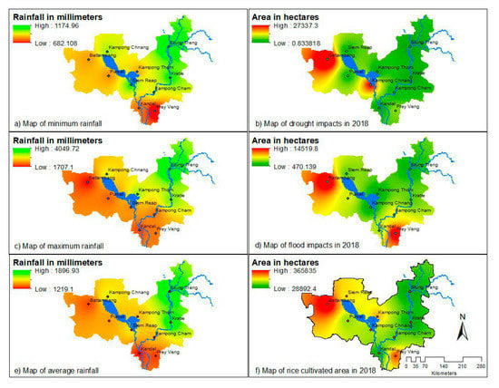
Figure 4.
Vulnerability to climate change on the cultivated areas of rice paddies in the Mekong River region and the Tonle Sap region.
A rainfall to calculate SPI for climate variability confirms a consistency between physical data and agricultural production loss and damage. Drought was more vulnerable to rice paddy cultivation in the Tonle Sap region if compared to the Mekong River. The Mekong River region experienced drought impact, but the severity was less even during ENSO period. Most of the affected farmers resided along the Tonle Sap and the Mekong River were impacted as a result of rising water levels. In Sangke, the flood was caused by heavy rain and the accumulation of water, affecting agricultural land, roads, houses, and other property [KI–10]. Commune councilors in Peam Ro indicated that the Mekong River rapidly reached a dangerous height of 7.5 m after increasing by over 1.5 m in just one day [FGD–2].
In Cambodia, drought is normally associated with an El Niño pattern, resulting in unusually high temperatures and surface water evaporation, as well as insufficient wet season rainfall with a delayed arrival and earlier departure. In 2018, the majority of the provinces in both regions received little or no rain from December to early January, as drought conditions worsened [Expert-FG]. These conditions destroyed 50,869 hectares of rice paddies in the Tonle Sap region and 7696 hectares in the Mekong River region. In Tonle Sap, drought hit almost all the provinces except Kompong Thom. The destruction was most extensive in Battambang (27,340 hectares) and Kampong Chhnang (20,143 hectares), with Siem Reap (1299 hectares) and Pursat (2087 hectares) being less affected. The drought period was prolonged, resulting in a significant economic crisis in the Tonle Sap region. Comparatively in the Mekong River region, Prey Veng (6112 hectares) was the most affected, followed by Kampong Cham (1584 hectares).
4.3. Interaction of Vulnerability Factors Incurred by Flood and Droughts
Vulnerability to climate hazards is influenced by linkages between a range of physical, social, economic, and environmental factors that prevent rice farmers in the two regions from securing sustainable livelihoods. In this study, thirteen attributes aligned with the physical, economic, social, and environmental factors defined by the United Nations in 2004 were proposed as vulnerability indicators related to flood and drought events, as illustrated in Table 2 [57]. A simultaneous multiple regression was used to combine these variables and estimate which had the most significant impact on the degree of vulnerability incurred as a result of flood and drought events.
Table 2.
Attributes influencing environmental, economic, and social vulnerability factors.
The multiple regression model indicates that the destruction of crops, damage to housing, and the interruption of schooling were significant vulnerability factors associated with flood events over the past 30 years. Seasonal floods have commonly occurred in Cambodia, causing damage to rice paddies, housing, and other infrastructures adjacent to the Tonle Sap and Mekong River, particularly when harvests were not possible before the onset of flood events [Expert-FG].
Floods with an extended duration tended to destroy rice paddies, while the hazard tended to be reduced if the flood durations were shorter [KI–2]. Flood events resulting from a combination of localized flash flooding and fluvial floods were described as disastrous destroying rice paddies, killing livestock, and damaging residences and infrastructure [KI–1]. However, flash floods were said to be preventable if sufficient irrigation infrastructure was in place. This infrastructure enables rice farmers to release water when necessary and retain it again after the flood risk has subsided [KI–4]. Farmers could also reduce flood risks by growing deep-water or floating rice varieties [KI–1]. Flood events also tended to distribute fertile mud to rice fields, resulting in good yields in the following season [KI–2]. Farmers in Peam Ro discussed conditions where floodwater regularly completely covered rice fields in the wet season [FGD–2], causing farmers to opt for irrigated crops in the dry season [KI–1]. The impact of flood events was said to be dependent on geography, with damage in the plain regions were higher than in the plateau regions [KI–3].
Flood events associated with heavy rain and windstorms were described as causing damage to housing, roads, bridges, schools, and other infrastructures. Houses built along the banks were particularly at risk of damage from storms and rapid fluvial flooding [KI–4]. In 2019, the water level during a flood in some parts of Pursat caused damage to the ground floor of houses in many villages [FGD–1]. Children were considered to be most vulnerable to floods as they disrupted from schooling for significant periods resulting in an increased chance of dropping out permanently [KI–3]. Some children left in the care of their grandparents as a result of their parents migrating for work were not well looked after and were at risk of drowning or not keeping up with their school work [KI–5].
The multiple regression model indicates that water scarcity, the destruction of crops, and an increased incidence of water-borne diseases were also significant vulnerability factors associated with drought events over the past 30 years. A more severe drought was associated with a greater area of damaged crops and the occurrence of waterborne disease. During drought events led by high temperature, rice farmers tended to refrain from planting new crops. This was a factor in farmer decisions when increased temperatures linked to an El Niño event in 2019 caused water shortages [Expert-FG]. Extended droughts in Cambodia caused the tributaries of the Tonle Sap and the Mekong River to dry up and strongly impact rice farmers. Hot weather associated with El Niño patterns, the late arrival of the rainy season, and irregular precipitation tend to cause stream levels to subside [Expert-FG].
Access to water for irrigating rice paddies becomes more challenging during drought events, directly impacting rice crops and livestock. Some poor households also have limited access to water for household consumption as they cannot afford to dig ponds or hire pumps for individual use [KI–5]. Droughts also cause reduced soil moisture retention, affecting crops. Uncertainty about when rain will arrive causes farmers to use direct seeding strategies as the only viable option to take advantage of unpredictable rainfall events, making it more difficult to apply fertilizer economically [KI–1].
Droughts are also associated with a reduction in the quantity and quality of water. Droughts tend to result in poor sanitation and hygiene practices, increasing the risk of water-borne diseases such as irritation, diarrhea, fever, food allergies, and high blood pressure for adults, as a result of limited access to drinking water. Climate hazards also result in physical health impacts linked to changes in food consumption, as well as psychological health impacts such as stress and depression as a result of lost income [Expert-FG]. The consequences of drought also include health problems specific to children such as malnutrition, which affects the physical development of the brain and immune system [KI–5].
5. Discussion
5.1. The Cause of Climate Variability and Severity of Flood and Drought
ENSO patterns [1] and human activities [85] have influenced climate variability in the Tonle Sap and the Mekong River, as well as the hydrology of the entire region. In Cambodia, climate change has caused more frequent and intense droughts and floods [86]. While there is a public perception that these events are natural and destructive, experts suggest that climate change is not always harmful to the vegetation, and that the impact of human activities on agricultural systems should not be ignored. For example, the collapse of a major dam in Laos in July 2018 resulted in a flash flood, causing the water level of the Mekong River in Stung Treng to rise to 12 m and the evacuation of thousands of Cambodian people from the affected areas.
In Cambodia, 80% of rice is cultivated in the wet season in rain-fed lowlands, uplands (2%), and deep-water (2%), while 16% is planted in irrigated fields in the dry season in low-lying areas of flooded parts of the Tonle Sap and Mekong River, where irrigation is available [87]. Rice farmers are still highly dependent on rain-fed rice cultivation in the wet season. Climate change modeling suggests that Cambodia will experience more frequent and intense climate hazards such as floods and drought. Rice cultivation will be greatly impacted due to this increased climate variability. Experts expect that intense flood will be experienced between late September and early October as rainfall peaks in the country. Droughts are expected to intensify as rainfall is reduced between late October and early November [1], leading rice farmers to struggle during harvesting, which is the most critical phase of rice production. This research finds that drought will have more severe impacts on rice cultivation than floods, with adaptive measures currently easier to apply to flood events.
Thus, water scarcity presents as the most significant barrier to rice cultivation in Cambodia. Local capacity, knowledge, and skills are only effective in managing the impacts of flash floods as a result of changing crop patterns and seed types. Rice farmers in flood-prone communities are knowledgeable about when floods come and can change cultivation cycles in response. For instance, some villagers grow early-maturing or deep-water rice varieties. Extended droughts make it particularly challenging to access water for crops, livestock and human uses as water sources dry up. Digging wells and installing water pumps are options of last resort for many communities, and there is no certainty that these strategies will be effective. Rice farmers cannot use groundwater directly for rice paddy production and need to store the water in ponds for one week before release into the fields. Groundwater resources generally contain limestone, meaning that they should be limited to use for human consumption rather than agricultural purposes. Thus, during severe droughts, there are often no suitable water resources for rice cultivation.
5.2. Vulnerability of Flood and Drought and Adaptation Measures Taken by Local Governments
The Cambodian Inter-Censal Agriculture Survey 2019 (CIAS19) indicates that Prey Veng and Battambang are the first- and second-largest rice-producing provinces in the country, with Kampong Cham and Pursat ranked 11th and 13th, respectively [88]. Peam Ro district in Prey Veng province and Sangke district in Battambang province are considered to be the rice bowl of Cambodia, with farmers maintaining their interest in rice cultivation to a greater extent than in the other districts. This is driven by access to markets through unofficial middlemen in Vietnam and Thailand, respectively [FGD-2, FGD-3]. In contrast, rice-farming families, especially young people, in Kompong Siem and Bakan can access alternative livelihoods in non-agricultural activities. They are less likely to be able to cope with the impacts of climate change and shrinking agricultural land ownership. Climate change has made rice farmers more vulnerable to the impacts of drought and flood events. This has reduced the significance of the contribution of agriculture to national employment from 78.1% of the population in 1991 to 34.5% in 2019 [89].
Rice farmers are particularly vulnerable to climate hazards because of significant rainfall fluctuations from year to year. In Peam Ro, most people remain dependent on rain-fed rice cultivation with less access to supplementary irrigation from pump machines, and ponds. For example, in 2018 both drought and flood affected the district in the same year [KI–8]. In contrast, rice farmers in Sangke can derive additional water for irrigation from supplementary sources, reducing their vulnerability [FGD–3]. Similarly, well-functioning supplementary irrigations in Kampong Siem increased water for irrigation during droughts, and also enabled the mitigation of flood impacts between July and September [FGD–4]. The majority of rice farmers in Bakan used pumps to adapt to climate impacts, some operating up to three machines concurrently: one in the main canal, and others located at branches of the distribution channel to the rice paddies. This contributes significantly to the cost of rice cultivation. Many farmers complained that this results in marginal benefits or even losses from production [KI–6].
Field observations in Kompong Siem and Sangke indicate that rice farmers had access not only to better public infrastructure (roads, schools, hospitals and irrigation) but also to better private assets such as better housing than in the other districts considered in the research. Floodplain farmers in Peam Ro had the lowest adaptive capacity as annual floods had greatly disturbed rice cultivation, affecting the school attendance of their children education and resulting in a greater incidence of water-borne diseases. Rice farmers in the other three districts shared a similar adaptive capacity due to superior access to physical infrastructure. This was indicated by officials from NGO officials as an important factor in reducing climate vulnerability. Many rice farmers suffer due to poorly functioning irrigation systems to support adaptive responses to flood and drought events [KI-3, KI-4, KI-6]. The focus group discussions revealed that district-level authorities in the four study areas all needed to work with NGOs and the line departments of the MAFF and Ministry of Environment (MoE) to improve the capacity of rice farmers to adopt adaptation measures. Local authorities indicated that they have insufficient resources to respond to social, economic and physical climate vulnerabilities alone [KI-5].
Improvements to irrigation systems were identified as having the most significant potential as an adaptation measure for vulnerability reduction. However, the development of this infrastructure is considered too expensive for central and provincial governments to provide for year-round access to water [KI-2]. Thus, rice farmers are required to make private investments in improving access to water resources. This is insufficient for those who are unable to afford to pay private operators for services such as pond digging and the use of pumps [KI-6]. Awareness-raising by local authorities and NGOs and learning from experience has gradually improved the adaptive capacity of rice farmers through strategies such as changing the timing of crop patterns and using supplementary sources of water for irrigation, as well as seeking alternative livelihood options. One key finding of this research is a confirmation that rice farmers in each of the four districts under study have chosen to invest privately supplementary irrigation infrastructure [FGD-1, FGD-2, FGD-3, & FGD-4].
5.3. Interaction among Environmental, Economic, and Social Factors to Climate Change
The existing literature identifies four types of vulnerability to climate hazards as proposed by the United Nations in 2004 [57]. In the two regions under study, flood and drought are the most significant climate hazards that cause physical, economic, social, and environmental vulnerabilities for rice farmers.
Other categories that may be used for analysis include natural [63] vs. social vulnerability [64]; vulnerability caused by internal [65] vs. external factors [66]; and/or long-term vs. short-term vulnerability. These characteristics of vulnerability may be used to consider alternative institutional arrangements for enhancing the implementation of policies and planning processes for mitigating the adverse impacts of climate change on rice cultivation. In general, environmental and social vulnerability factors are long-term considerations, while physical and economic vulnerability factors tend to be dealt with in the short term. Flood and drought events cause economic vulnerabilities such as the destruction of crops, while flood events also cause physical damage to housing. The development of robust local adaptation strategies such as changing crop patterns, seed types, and the scheduling of their use; investing in climate-resilient infrastructure has also been used to mitigate these physical and economic vulnerabilities.
Recovery from environmental and social vulnerabilities is a longer-term process and requires resilience. High temperatures and rainfall variability are two influential climate change impacts that cause more frequent and intense flood and drought events. While drought events lead to environmental water scarcity, both flood and drought events lead to significant social vulnerabilities. For instance, access to education is impacted by flood events and water-borne diseases are spread during drought events.
Adaption measures derived from different country contexts may be useful in understanding how to reduce environmental and social vulnerabilities linked to climate variability in the Tonle Sap and the Mekong River regions. This includes (i) the improvement of local institutional capacity and financial resources in Nicaragua [90]; (ii) the implementation of integrated water resources management strategies along with innovative technologies in Mexico [91]; (iii) disaster risk reduction and preparedness and improved water governance in the Global South [92]; and (iv) participatory water allocation mechanisms to manage water conflicts, balance development priorities, and conserve basin ecosystems in China [93]. Reflecting on these experiences may be useful for informing adaption measures to reduce vulnerabilities to climatic variability in the Tonle Sap and the Mekong River regions. The role of commune and district authorities should be strengthened through the implementation of integrated water resource management approaches to distributing water resources equitably to all rice farmers. Integrated water resource management should be made through joint investments among local government, private sector, and communities on supplementary irrigations for a short-term plan and large-scale irrigations for a long-term plan. Increased large-scale and supplementary irrigation systems will help reduce conflicts among rice farmers over the access to water for cultivation. Moreover, decisions should be decentralized to these local institutions by distributing appropriate human and financial resources to enable the collective self-management of adaptation measures. This includes the implementation of disaster preparedness activities to inform a timely and effective response to flood and drought events. Emergency preparedness and response are helpful to build capacity for conducting risk assessments and put them into action for disaster mitigation in their communities. Moreover, an early warning system should be established to timely inform and respond to floods and drought.
6. Conclusions
Based on our findings in the four districts studied in the Tonle Sap and the Mekong River regions, along with some additional insights about negative impacts of climate change on rice cultivation in Cambodia overall, we conclude the following: (i) Rainfall variability and highly significant changes to a range of climate attributes between 1994 and 2018 have led to an increase in the frequency and intensity of flood and drought events across and within each region and province. A survey found that local perceptions of climate change indicate increasing temperatures, greater water scarcity, and reduced soil moisture over this period. (ii) Over the past 30 years, drought has caused more severe climate vulnerabilities to rice paddy cultivation, with the Tonle Sap region tending to experience a higher degree of vulnerability to both types of climate hazard. (iii) Flood and drought events caused social and economic vulnerabilities, while flood events caused physical damages, drought caused environmental vulnerabilities. Physical and economic factors are considered short-term impacts. However, recovery from environmental and social vulnerabilities is a longer-term implication and requires adaption and resilience.
This paper adopted the UN risk assessment framework “interaction of vulnerability factors” [57]. This framework has helped assess the vulnerability of rice farmers in the Tonle Sap and the Mekong River to climatic hazards in Cambodia as they tend to be aligned with disaster risks. The findings of this research provide insights into the negative impacts of climate variability on riverine communities that are reliant on rain-fed rice cultivation. This study addresses a gap in the literature by contributing a comparative empirical study on the vulnerabilities of rice farmers in the Tonle Sap and the Mekong River to climate variability and the adaptation and resilience strategies applied in response. An identification of attributes for the four types of vulnerability requires a high level of participatory approach involving all the key stakeholders. This framework is also applicable for other riverine communities of Mekong countries such as Lao PDR, Vietnam, and Thailand because their climatic hazards are associated with disaster risks. Adaptation measures by local authorities at commune and district levels require long-term integrated water resources management approaches to collectively mitigate these negative impacts.
Author Contributions
Conceptualization, S.S.; methodology, S.S., N.C. and S.H.; formal analysis, S.S., N.C. and P.N.; resources, S.S., P.N., N.C. and S.H.; writing—original draft preparation, S.S.; writing—review and editing, S.S., N.C., P.N. and S.H.; supervision, S.S. All authors have read and agreed to the published version of the manuscript.
Funding
This research was funded by Partnerships for Enhanced Engagement in Research (PEER) Cycle 7, which is administered by the U.S. National Academies of Sciences, Engineering, and Medicine (NASEM). The United States Agency for International Development (USAID) has joined with several other U.S. Government agencies to support PEER under USAID Agreement AID-OAA-A-11-00012.
Institutional Review Board Statement
Not applicable.
Informed Consent Statement
Not applicable.
Data Availability Statement
Raw data regarding rainfall and cultivated area of rice paddies between 1994 and 2018 was sourced from MoWRaM and the MAFF to determine values for the SPI and drawing climate vulnerability maps. This data is not available online but may be accessed upon official request to the research team.
Acknowledgments
The author greatly appreciates the valuable comments and suggestions in preparing this paper for publication from the editorial board of Sustainability, the five anonymous reviewers and Simon Ross. Thanks to Kelly Robbins [NASEM Senior Program Officer], Marcia McNutt [President of the National Academy of Sciences], Robert J. Hijmans [University of California, Davis] and Aniruddha Ghosh [University of California, Davis] for their support and guidance to conduct the research.
Conflicts of Interest
The authors declare no conflict of interest.
Appendix A
Table A1.
List of interviewees, focus-group discussions, and expert meeting.
Table A1.
List of interviewees, focus-group discussions, and expert meeting.
| Code | Participant(s) | Date |
|---|---|---|
| KI-1 | An official from the General Directorate of Agriculture, Ministry of Agriculture, Forestry, and Fisheries | September 2020 |
| KI-2 | An official from the Provincial Department of Agriculture Forestry & Fisheries in Tboung Khmum | September 2020 |
| KI-3 | An official from Action Against Hunger-Cambodia | September 2020 |
| KI-4 | An official from Live & Learn Cambodia | November 2020 |
| KI-5 | An official from the Child Rights Foundation | November 2020 |
| K1-6 | An official from the Forest and Livelihood Organization (FLO) | November 2020 |
| KI-7 | Commune Council Committee in Bakan district of Pursat Province | January 2020 |
| KI-8 | Commune Council Committee in Peam Ro District of Prey Veng Province | February 2020 |
| KI-9 | Commune Council Committee in Kompong Siem District of Kompong Cham Province | February 2020 |
| KI-10 | Commune Council Committee in Sangke District of Battambang Province | February 2020 |
| FGD-1 | Group discussion among commune heads in Bakan district of Pursat province | January 2020 |
| FGD-2 | Group discussion among commune heads in Peam Ro district of Prey Veng province | February 2020 |
| FGD-3 | Group discussion among commune head in Sangke District of Battambang Province | February 2020 |
| FGD-4 | Group discussion among Kompong Siem District of Kompong Cham Province | February 2020 |
| Expert-FG | An expert meeting to validate the findings and to provide a technical explanation of quantitative data. | March 2020 |
References
- Keskinen, M.; Chinvanno, S.; Kummu, M.; Nuorteva, P.; Sindvongs, A.; Varis, O.; Vastila, K. Climate change and water resources in the Mekong River Basin: Putting adaption into the context. J. Water Clim. Chang. 2010, 2, 103–117. [Google Scholar] [CrossRef]
- Thoeun, H.C. Observed and projected changes in temperature and rainfall in Cambodia. Weather Clim. Extrem. 2015, 7, 61–71. [Google Scholar] [CrossRef] [Green Version]
- McSweeney, C.; New, M.; Lizcano, G. Cambodia Climate Change Profile; Oxford University: Oxford, UK, 2008. [Google Scholar]
- Mcsweeney, C.; New, M.; Lizcano, G.; Lu, X. The UNDP Climate Change Country Profiles: Improving the accessibility of observed and projected climate information for studies of climate change in developing countries. Bull. Am. Meteorol. Soc. 2010, 91, 157–166. [Google Scholar] [CrossRef] [Green Version]
- Eastham, J.; Mpelaskova, F.; Mainuddin, M.; Ticehurst, C.; Dyce, P.; Hodgson, G. Mekong River Basin Water Resources Assessment: Impact of Climate Changes; CSIRO Water for a Healthy Country National Research Flagship: Canberra, Australia, 2008.
- MRC. Overview of the Hydrology of the Mekong Basin; Mekong River Commission: Vientiane, Laos, 2005. [Google Scholar]
- Juneng, L.; Tangang, F.T. Evolution of ENSO-related rainfall anomalies in Southeast Asia region and its relationship with atmosphere–ocean variations in Indo-Pacific sector. Clim. Dyn. 2005, 25, 337–350. [Google Scholar] [CrossRef]
- Wang, B.; Wu, R.; Fu, X. Pacific–East Asian teleconnection: How does ENSO affect East Asian climate? J. Clim. 2000, 13, 1517–1536. [Google Scholar] [CrossRef]
- CNMC. The State of Climate Change Management in Cambodia; Cambodia National Mekong Committee: Phnom Penh, Cambodia, 2010.
- Murphy, T.; Irvine, K.; Sampson, M. stress of climate change on water management in Cambodia with a focus on rice production. Clim. Dev. 2013, 5, 77–92. [Google Scholar] [CrossRef]
- IPCC. Climate Change 2007: Synthesis Report; Intergovernmental Panel on Climate Change: Geneva, Switzerland, 2007. [Google Scholar]
- Evans, A. Resource Scarcity, Climate Change and the Risk of Violent Conflict; Center on International Cooperation New York University: New York, NY, USA, 2010. [Google Scholar]
- MoP. Provisional Population Totals of General Population Census of Cambodia 2019; Ministry of Planning: Phnom Penh, Cambodia, 2019.
- World Bank. World Development Indicator; World Bank: Washington, DC, USA, 2009. [Google Scholar]
- MoP. Cambodia Socio-Economic Survey 2017; Ministry of Planning: Phnom Penh, Cambodia, 2018.
- ASEAN Secretariat. ASEAN Key Figures 2019; ASEAN Secretariat: Jakarta, Indonesia, 2019; Available online: https://www.aseanstats.org/publication/asean-key-figures-2019/ (accessed on 12 April 2020).
- Nesbitt, H.J. Rice Production in Cambodia; International Rice Research Institute: Manila, Philippine, 1997. [Google Scholar]
- IFAD. Report on Agriculture Policy Research Study. Modelling Agriculture Sector: Long-Term Vision and Policy Orientation; International Fund for Agricultural Development: Phnom Penh, Cambodia, 2019. [Google Scholar]
- World Bank. Cambodia Economic Update: Upgrading Cambodia in Global Value Chains; World Bank Group: Washington, DC, USA, 2019. [Google Scholar]
- MRC. State of the Basin Report 2018; Mekong River Commission: Vientiane, Laos, 2019. [Google Scholar]
- Yu, B.; Diao, X. Cambodia’s Agricultural Strategy: Future Development Options for the Rice Sector; Cambodia Development Resource Institute (CDRI); Council for Agricultural and Rural Development (CARD); International Food Policy Research Institute (IFPRI): Phnom Penh, Cambodia, 2011.
- Keskinen, M. The Lake with floating villages: Socio-economic analysis of the Tonle Sap Lake. Int. J. Water Resour. Dev. 2006, 22, 463–480. [Google Scholar] [CrossRef]
- Poulton, P.L.; Dalgliesh, N.P.; Vang, S.; Roth, C.H. Resilience of Cambodian lowland rice farming systems to future climate uncertainty. Field Crop. Res. 2016, 198, 160–170. [Google Scholar] [CrossRef]
- MoE. Climate Change Action Plan 2016–2018; Ministry of Environment: Phnom Penh, Cambodia, 2016.
- Baran, E.; Myschowoda, C. Have Fish Catches Been Declining in the Mekong River Basin? Helsinki University of Technology: Helsinki, Finland, 2008. [Google Scholar]
- Sok, S.; Lebel, L.; Bastakoti, R.C.; Thau, S.; Samath, S. Role of villagers in building community resilience through disaster risk management: A case study of a flood-prone village on the banks of the Mekong River in Cambodia. In Environmental Change and Agricultural Sustainability in the Mekong Delta; Springer: Dordrecht, The Netherlands, 2011; pp. 241–255. [Google Scholar]
- NCDM. Cambodia Disaster Damage & Loss Information System (CamDi). 2020. Available online: http://camdi.ncdm.gov.kh/DesInventar/profiletab.jsp?countrycode=kh2&continue=y (accessed on 12 April 2020).
- Few, R. Flooding, vulnerability and coping strategies: Local responses to a global threat. Prog. Dev. Stud. 2003, 3, 43–58. [Google Scholar] [CrossRef]
- Chhinh, N. Drought, Drought Vulnerability and Adaptation Policy in Cambodia with Reference to the Farming Sector. Ph.D. Thesis, Flinders University, School of the Environment, Adelaide, Australia, 2016. [Google Scholar]
- ADB. The Tonle Sap Basin Strategy; Asian Development Bank: Manila, Philippine, 2005. [Google Scholar]
- Chhinh, N. Drought Studies in Cambodia; United Nations Development Programme: Phnom Penh, Cambodia, 2019. [Google Scholar]
- Zougmoré, R.B.; Partey, S.T.; Totin, E.; Ouédraogo, M.; Thornton, P.; Karbo, N.; Sogoba, B.; Dieye, B.; Campbell, B.M. Science-policy interfaces for sustainable climate-smart agriculture uptake: Lessons learnt from national science-policy dialogue platforms in West Africa. Int. J. Agric. Sustain. 2019, 17, 367–382. [Google Scholar] [CrossRef] [Green Version]
- IPCC. Climate Change 2014: Impacts, Adaptation, and Vulnerability. Part A: Global and Sectoral Aspects. Contribution of Working Group II to the Fifth Assessment Report of the Intergovernmental Panel on Climate Change; Cambridge University Press: Cambridge, UK, 2014. [Google Scholar]
- Deressa, T.; Hassan, R.; Poonyth, D. Measuring the Impact of Climate Change on South African Agriculture: The Case of Sugar Cane Growing Regions. Agrekon 2005, 44, 524–542. [Google Scholar] [CrossRef] [Green Version]
- Ojo, T.O.; Baiyegunhi, L.J.S. Climate change perception and its impact on net farm income of smallholder rice farmers in South-West, Nigeria. J. Clean. Prod. 2021, 310, 127–373. [Google Scholar] [CrossRef]
- Furuya, J.; Koyama, O. Impacts of climatic change on world agricultural product markets: Estimation of macro yield functions. ARQ Jpn. Agric. Res. Q. 2005, 39, 121–134. [Google Scholar] [CrossRef] [Green Version]
- Alam, M.; Sawhney, P. Regional overview. In Status of Climate Change Adaptation in Asia and the Pacific; Springer: New York, NY, USA, 2019; pp. 27–40. [Google Scholar]
- Panda, D.; Barik, J. Flooding Tolerance in Rice: Focus on Mechanisms and Approaches. Rice Sci. 2021, 28, 43–57. [Google Scholar] [CrossRef]
- Alam, M.; Lee, J.; Sawhney, P. (Eds.) Status of Climate Change Adaptation in Asia and the Pacific; Springer International Publishing: Geneva, Switzerland, 2018; pp. 183–209. [Google Scholar]
- Depledge, J. Climate Change in Focus: The IPCC Third Assessment Report; Briefing Paper New Series, No. 29; Royal Institute of International Affairs: London, UK, 2002. [Google Scholar]
- Sarker, M.A.R.; Alam, K.; Gow, J. Assessing the effects of climate change on rice yields: An econometric investigation using Bangladeshi panel data. Econ. Anal. Policy 2014, 44, 405–416. [Google Scholar] [CrossRef]
- Peng, S.; Huang, J.; Sheehy, J.E.; Laza, R.C.; Visperas, R.M.; Zhong, X.; Centeno, G.S.; Khush, G.S.; Cassman, K.G. Rice yields decline with higher night temperature from global warming. Proc. Natl. Acad. Sci. USA 2004, 101, 9971–9975. [Google Scholar] [CrossRef] [Green Version]
- Agarwal, A. Forecasting Rice Yield under Climate Change Scenarios for Northeast Thailand (MSC Thesis); Asian Institute of Technology: Bangkok, Thailand, 2008. [Google Scholar]
- He, W.; Liu, Y.; Sun, H.; Taghizadeh-Hesary, F. How Does Climate Change Affect Rice Yield in China? Agriculture 2020, 10, 441. [Google Scholar] [CrossRef]
- Singh, K.; McClean, C.J.; Büker, P.; Hartley, S.E.; Hill, J.K. Mapping regional risks from climate change for rainfed rice cultivation in India. Agric. Syst. 2017, 156, 76–84. [Google Scholar] [CrossRef] [PubMed]
- Bossa, A.Y.; Hounkpè, J.; Yira, Y.; Serpantié, G.; Lidon, B.; Fusillier, J.L.; Sintondji, L.O.; Tondoh, J.E.; Diekkrüger, B. Managing new risks of and opportunities for the agricultural development of West-African floodplains: Hydroclimatic conditions and implications for rice production. Climate 2020, 8, 11. [Google Scholar] [CrossRef] [Green Version]
- Rondhi, M.; Fatikhul Khasan, A.; Mori, Y.; Kondo, T. Assessing the role of the perceived impact of climate change on national adaptation policy: The case of rice farming in Indonesia. Land 2019, 8, 81. [Google Scholar] [CrossRef] [Green Version]
- Chhetri, N.B.; Easterling, W.E. Adapting to climate change: Retrospective analysis of climate technology interaction in the rice-based farming system of Nepal. Ann. Assoc. Am. Geogr. 2010, 100, 1156–1176. [Google Scholar] [CrossRef]
- Esham, M.; Garforth, C. Climate change and agricultural adaptation in Sri Lanka: A review. Clim. Dev. 2013, 5, 66–76. [Google Scholar] [CrossRef]
- Malone, L.E.; Engle, L.N. Evaluating regional vulnerability to climate change: Purposes and methods. Wiley Interdiscip. Rev. Clim. Chang. 2011, 2, 462–474. [Google Scholar] [CrossRef]
- Panda, A. Vulnerability to climate variability and drought among small and marginal farmers: A case study in Odisha, India. Clim. Dev. 2017, 9, 605–617. [Google Scholar] [CrossRef]
- Eakin, H.; Bojorquez-Tapia, L.A. Insights into the composition of household vulnerability from multicriteria decision analysis. Glob. Environ. Chang. 2008, 18, 112–127. [Google Scholar] [CrossRef]
- Vincent, K. Uncertainty in adaptive capacity and the importance of scale. Glob. Environ. Chang. 2007, 17, 12–24. [Google Scholar] [CrossRef]
- o’Brien, K.; Leichenko, R.; Kelkar, U.; Venema, H.; Aandahl, G.; Tompkins, H.; Javed, A.; Bhadwal, S.; Barg, S.; Nygaard, L.; et al. Mapping vulnerability to multiple stressors: Climate change and globalization in India. Glob. Environ. Chang. 2004, 14, 303–313. [Google Scholar] [CrossRef]
- Cutter, S.L.; Boruff, B.J.; Shirley, W.L. Social Vulnerability to Environmental Hazards; Routledge: London, UK, 2012. [Google Scholar]
- Downing, T.E.; Butterfield, R.; Cohen, S.; Huq, S.; Moss, R.; Rahman, A.; Sokona, Y.; Stephen, L. Climate Change Vulnerability: Linking Impacts and Adaptation; University of Oxford: Oxford, UK, 2001. [Google Scholar]
- United Nations. Living with Risk: A Global Review of Disaster Reduction Initiatives; United Nations Inter-Agency Secretariat of the International Strategy for Disaster Reduction: Geneva, Switzerland, 2004. [Google Scholar]
- Hinkel, J. Indicators of vulnerability and adaptive capacity: Towards a clarification of the science policy interface. Glob. Environ. Chang. 2011, 21, 198–208. [Google Scholar] [CrossRef]
- Susman, P.; O’Keefe, P.; Wisner, B. Global Disasters: A Radical Interpretation. In Interpretations of Calamity from the Viewpoint of Human Ecology; Hewitt, K., Ed.; Allen and Unwin: Boston, MA, USA, 1984; pp. 264–283. [Google Scholar]
- Mitchell, J.K. Hazards research. In Geography in America; Gaile, G.L., Willmott, C.J., Eds.; Merill: Colombus, OH, USA, 1989; pp. 410–424. [Google Scholar]
- Wolf, S.; Hinkel, J.; Hallier, M.; Bisaro, A.; Lincke, D.; Ionescu, C.; Klein, R.J. Clarifying vulnerability definitions and assessments using formalisation. Int. J. Clim. Chang. Strateg. Manag. 2013, 5, 54–70. [Google Scholar] [CrossRef]
- Ciurean, R.L.; Schröter, D.; Glade, T. Conceptual Frameworks of Vulnerability Assessments for Natural Disasters Reduction. In Approaches to Disaster Management—Examining the Implications of Hazards, Emergencies and Disasters, Chapter 1; Tiefenbacher, J., Ed.; InTech: Rijeka, Croatia, 2013; pp. 1–32. [Google Scholar]
- Smit, B.; Burton, I.; Klein, R.J.T.; Street, R. ‘The science of adaptation: A framework for assessment’. Mitig. Adapt. Strateg. Glob. Chang. 1999, 4, 199–213. [Google Scholar] [CrossRef]
- Brooks, N. Vulnerability, Risk and Adaptation: A Conceptual Framework; Tyndall Centre for Climate Change Research: Norwich, UK, 2003. [Google Scholar]
- Sanchez-Rodriguez, R. Cities and Global Environmental Change: Challenges and Opportunities for a Human Dimension Perspective. Ihdp Update 2002, 3, 1–3. [Google Scholar]
- Bohle, H.-G. Vulnerability and Criticality: Perspectives from Social Geography. Ihdp Update 2001, 2, 3–5. [Google Scholar]
- McLaughlin, P.; Dietz, T. Structure, agency and environment: Toward an integrated perspective on vulnerability. Glob. Environ. Chang. 2008, 18, 99–111. [Google Scholar] [CrossRef]
- Moss, R.H.; Brenkert, A.L.; Malone, E.L. Vulnerability to Climate Change: A Quantitative Approach; Pacific Northwest National Laboratories: Richland, WA, USA, 2001.
- Kasperson, J.X.; Kasperson, R.E.; Turner, B.L., II; Hsieh, W.; Schiller, A. Vulnerability to global environmental change. In The Human Dimensions of Global Environmental Change; Diekmann, A., Dietz, T., Jaeger, C.C., Rosa, E.A., Eds.; MIT Press: Cambridge, MA, USA, 2002. [Google Scholar]
- Adger, W.N. Social Vulnerability to Climate Change and Extremes in Coastal Vietnam. World Dev. 1999, 27, 249–269. [Google Scholar] [CrossRef]
- Bohle, H.; Watts, M. The space of vulnerability: The causal structure of hunger and famine. Prog. Hum. Geogr. 1993, 13, 43–67. [Google Scholar]
- O’Brien, K.; Eriksen, S.; Schjolen, A.; Nygaard, L. What’s in a Word? Conflicting Interpretations of Vulnerability in Climate Change Research; Oslo University: Oslo, Norway, 2004. [Google Scholar]
- Christoplos, I.; McGinn, C. Climate change adaptation from a human rights perspective: Civil society experiences in Cambodia. In Forum for Development Studies; Routledge: London, UK, 2016; Volume 43, pp. 437–461. [Google Scholar] [CrossRef] [Green Version]
- Mainuddin, M.; Kirby, M.; Hoanh, C.T. Water productivity responses and adaptation to climate change in the lower Mekong basin. Water Int. 2012, 37, 53–74. [Google Scholar] [CrossRef]
- Natarajan, N.; Brickell, K.; Parsons, L. Climate change adaptation and precarity across the rural–urban divide in Cambodia: Towards a ‘climate precarity’ approach. Environ. Plan. E Nat. Space 2019, 2, 899–921. [Google Scholar] [CrossRef]
- Nuorteva, P.; Keskinen, M.; Varis, O. Water, livelihoods and climate change adaptation in the Tonle Sap Lake area, Cambodia: Learning from the past to understand the future. J. Water Clim. Chang. 2010, 1, 87–101. [Google Scholar] [CrossRef]
- Sok, S.; Yu, X. Adaptation, resilience and sustainable livelihoods in the communities of the Lower Mekong Basin, Cambodia. Int. J. Water Resour. Dev. 2015, 31, 575–588. [Google Scholar] [CrossRef]
- Downing, T.E.; Patwardhan, A. Vulnerability Assessment for Climate Adaptation; United Nations Development Programme: New Yok, NY, USA, 2003. [Google Scholar]
- Kelly, P.M.; Adger, W.N. Theory and practice in assessing vulnerability to climate change and facilitating adaptation’. Clim. Chang. 2000, 47, 325–352. [Google Scholar] [CrossRef]
- Handmer, J.W.; Dovers, D.; Downing, T.E. Social vulnerability to climate change and variability. Mitig. Adapt. Strateg. Glob. Chang. 1999, 4, 267–281. [Google Scholar] [CrossRef]
- Thomas, T.S.; Ponlok, T.; Bansok, R.; De Lopez, T.; Chiang, C.; Phirun, N.; Chhun, C. Cambodian Agriculture: Adaptation to Climate Change Impact; International Food Policy Research Institute: Washington, DC, USA, 2013. [Google Scholar]
- Yamane, T. Statistics: An Introductory Analysis, 2nd ed.; Harper and Row: New York, NY, USA, 1967. [Google Scholar]
- McKee, T.B.; Doesken, N.J.; Kleist, J. The Relationship of Drought Frequency and Duration to Time Scales. In Proceedings of the 8th Conference on Applied Climatology, Anaheim, CA, USA, 17–22 January 1993. [Google Scholar]
- Thom, H.C.S. Some Methods of Climatological Analysis; Secretariat of the World Meteorological Organization: Geneva, Switzerland, 1966. [Google Scholar]
- Le, T.V.H.; Nguyen, H.N.; Wolanski, E.; Tran, T.C.; Haruyama, S. The combined impact on the flooding in Vietnam’s Mekong River delta of local man-made structures, sea level rise, and dams upstream in the river catchment. Estuar. Coast. Shelf Sci. 2007, 71, 110–116. [Google Scholar] [CrossRef]
- MRC. Adaptation to Climate Change in the Countries of the Lower Mekong Basin; Mekong River Commission: Vientiane, Laos, 2009. [Google Scholar]
- MAFF. Cambodia—Agricultural Sector Diversification Project: Indigenous Peoples Plan: Indigenous People Planning Framework; Ministry of Agriculture Forestry and Fishery: Phnom Penh, Cambodia, 2019.
- MoP. Cambodia Inter-Censal Agriculture Survey 2019 (CIAS19) Final Report; Ministry of Planning: Phnom Penh, Cambodia, 2019.
- World Bank. Employment in Agriculture (% of Total Employment) (Modeled ILO Estimate)–Cambodia. 2021. Available online: https://data.worldbank.org/indicator/SL.AGR.EMPL.ZS?locations=KH (accessed on 27 May 2021).
- World Bank. Climate Change Impacts on Water Resources and Adaptation in the Rural Water Supply and Sanitation Sector in Nicaragua; World Bank: Washington, DC, USA, 2013. [Google Scholar]
- Gloria, S.M.; Marina, H.P. Implications of Climate Change on Water Resource Management in Megacities in Developing Countries: Mexico City Case Study. Future 2016, 5, 47–68. [Google Scholar] [CrossRef]
- MacAlister, C.; Subramanyam, N. Climate change and adaptive water management: Innovative solutions from the global South. Water Int. 2018, 43, 133–144. [Google Scholar] [CrossRef] [Green Version]
- Yang, L.E.; Chan, F.K.S.; Scheffran, J. Climate change, water management and stakeholder analysis in the Dongjiang River basin in South China. Int. J. Water Resour. Dev. 2018, 34, 166–191. [Google Scholar] [CrossRef] [Green Version]


Publisher’s Note: MDPI stays neutral with regard to jurisdictional claims in published maps and institutional affiliations. |
© 2021 by the authors. Licensee MDPI, Basel, Switzerland. This article is an open access article distributed under the terms and conditions of the Creative Commons Attribution (CC BY) license (https://creativecommons.org/licenses/by/4.0/).