Review

An Integrated Approach for Post-Disaster Flood Management Via the Use of Cutting-Edge Technologies and UAVs: A Review

by
Hafiz Suliman Munawar
1,
Ahmed W. A. Hammad
1,
S. Travis Waller
2,
Muhammad Jamaluddin Thaheem
3,* and
Asheem Shrestha
3
1
School of Built Environment, University of New South Wales, Kensington, Sydney, NSW 2052, Australia
2
School of Civil and Environmental Engineering, University of New South Wales, Kensington, Sydney, NSW 2052, Australia
3
Geelong Waterfront Campus, School of Architecture and Built Environment, Locked Bag 20001, Deakin University, Geelong, VIC 3220, Australia
*
Author to whom correspondence should be addressed.
Sustainability 2021, 13(14), 7925; https://doi.org/10.3390/su13147925
Submission received: 23 May 2021 / Revised: 1 July 2021 / Accepted: 7 July 2021 / Published: 15 July 2021
(This article belongs to the Special Issue Risk Management as a Tool for Sustainability)

Abstract

:
Rapid advances that improve flood management have facilitated the disaster response by providing first aid services, finding safe routes, maintaining communication and developing flood maps. Different technologies such as image processing, satellite imagery, synthetic imagery and integrated approaches have been extensively analysed in the literature for disaster operations. There is a need to review cutting-edge technologies for flood management. This paper presents a review of the latest advancements in the flood management domain based on image processing, artificial intelligence and integrated approaches with a focus on post-disaster. It answers the following research questions: (1) What are the latest developments in image processing for flood management in a post-disaster scenario? (2) What are the latest techniques for flood management based on artificial intelligence in a post-disaster scenario? (3) What are the existing gaps in the selected technologies for post-disaster? (4) How can the authorities improve the existing post-disaster management operation with cutting-edge technologies? A novel framework has been proposed to optimise flood management with the application of a holistic approach.

1. Introduction

Climate change impacts have increased the events of natural disasters around the world. The impacts of these natural events, such as floods, drought, fire, cyclones, hurricanes and others, are profound on developing countries as well as on developed countries [1,2,3]. A lot of research has been carried out lately to build efficient early warning systems and improve disaster management ways. Natural events cannot be stopped from being happening; however, effective disaster management approaches can minimise the destruction and reduce the number of casualties [4,5]. Different methods of disaster management are applicable at three stages of the event. First is the pre-disaster stage, which emphasises monitoring or early warning system to alert the authorities about the incoming natural event; second is damage control during the event, and third is the post-disaster recovery phase to bring life back to normality [6,7,8]. To address the challenges of natural events, the International Emergency Management System (IEMS) was established in 1993 to set up procedures and guidelines for countries to adapt during a crisis scenario. According to the Millenium Development Goals (MDG) 2015, the latest information technology and communication tools can be used for improving the relief response during a natural disaster [9,10,11,12]. The relief efforts can be accelerated to reach out to a maximum number of people in a short time with the use of advanced technology. Emerging technologies can, therefore, play a vital role in developing disaster resilient infrastructure and attain effective disaster management.
There is a knowledge gap in the field of the disaster management process. Special focus needs to be laid on climate change and associated risks with the use of advanced tools. Advanced early warning systems need to be developed based on the framework, algorithms and concepts. Achieving disaster resilience is a major goal aimed by the UN to achieve by 2030 [13,14,15]. Different countries around the world have prioritised to achieve this target which can be achieved by tapping into human resources, developing cutting-edge technologies and increasing adaptability through authorities. Resilience infrastructure and capabilities should focus on reducing calamities and economic losses [16,17,18]. The only way forward is to timely detect the hazard and minimise it with the application of appropriate technology.
Innovative disaster management approaches that implement information technology, artificial intelligence, ICT tools and machine learning will facilitate all stages of a disaster, such as floods [19,20,21]. The innovation can take place either through different concepts, ways, technology or community-based approaches. Interdisciplinary concepts and ideas will develop different processes to carry out efficient pre- and post-flood management practices [22,23,24]. Collaborating with different stakeholders, integrating science and technology and active participation from the community will facilitate the development of effective tools and methodologies, their implementation and uptake at different levels. Japan, being prone to disasters, experiences human casualties, damage to infrastructure and economic losses each year [25]. Specialised emergency management systems have been devised to mitigate hazards [26]. A multi-level system was established for assessing the capabilities of emergency management from the top government level to the authorities below [27]. Similarly, in China, emergency management systems were developed after the spread of SARS to cope with any disaster crisis through formulating different laws and applying computational intelligence. A lot of research has been carried out in China to introduce unconventional emergency plans and practices that involve developing new rules, taking into consideration various constraints and contradictory issues. It involves challenging intelligent data estimations and making supportive decisions [28,29].
The decision-making process is essential in each phase of disaster management, as it impacts the effectiveness of the rescue mission and events [30,31,32]. This decision making is reliant on big data analysis, which is challenging as compared to traditional data analysis. This highlights the need for computational intelligence, real-time algorithms that can make timely decisions, analyse the different structures of data, extract the data and present it through visualisation strategies [33,34,35,36]. In most flood management systems, the application of computational intelligence is viral for making timely decisions. There is a lot of traction on the applicability of the computationally intelligent technique for flood management systems. There is a need to review the latest computational technology and identify existing gaps in flood management [37]. A recent development in computational technologies is applying artificial intelligence and machine learning algorithms for weather predictions, flood-affected regions, damage detection and others [38]. Researchers are also investigating various algorithms for analysing large scale data sets that would solve the real-time issues with minimum computational time. Robust risk-related data analysis, enhancing computational potential and applying different sensors within drones and satellites for capturing real-time data analysis are a few of the many domains that researchers are investigating [38,39,40,41]. These include observing disaster areas by employing drones and analysing real-time data for mapping the area and finding the safest route to reach the victims during floods.
The information systems can be improved for meteorological purposes by applying remote sensors and drones, enabling planning for disaster events [42]. Such information about the oncoming flood will enable the authorities to use diversion strategies or plan routes for evacuating the area before the region is hit by the flood [39]. These resilient measures are only possible with the help of innovative technologies and carrying out further development in this field. It is estimated that weather forecasting and meteorological data analysis will be highly reliant on artificial and computational intelligence in the future. The authorities will utilise these technologies for communicating disaster predictions, the extent of risks, creating awareness among the community to take safety precautions and devising strategies [43].
Systematic background research will be carried out to identify the latest technologies that have been used in this domain for accurately determining a natural disaster: floods. The paper will classify technologies based on image processing techniques, artificial intelligence and integrative approaches for capturing the data and analysing it. Techniques will be evaluated based on their importance, performance, application and limitations and their potential acceptance by the authorities as management systems and decision-making based on real-time data. This review will improve the understanding of the latest technology and select a suitable model for flood management in a specific area. The following research questions are formulated and will be answered based on this review:
RQ-1.
What are the latest developments in image processing for flood management in a post-disaster scenario?
RQ-2.
What are the latest techniques for flood management based on artificial intelligence in a post-disaster scenario?
RQ-3.
What are the existing gaps in the selected technologies for post-disaster?
RQ-4.
How can the authorities improve the existing post-disaster management operation with cutting-edge technologies?
The rest of the paper is organised as follows: Section 2 defines the methods and materials carried out during this study, while Section 3 presents the results of the study by providing a comprehensive analysis of the selected cutting-edge flood management techniques. Section 4 discusses the results of this research, identifies the research gaps and presents a solution to overcome them. Section 5 outlines the conclusion of the study.

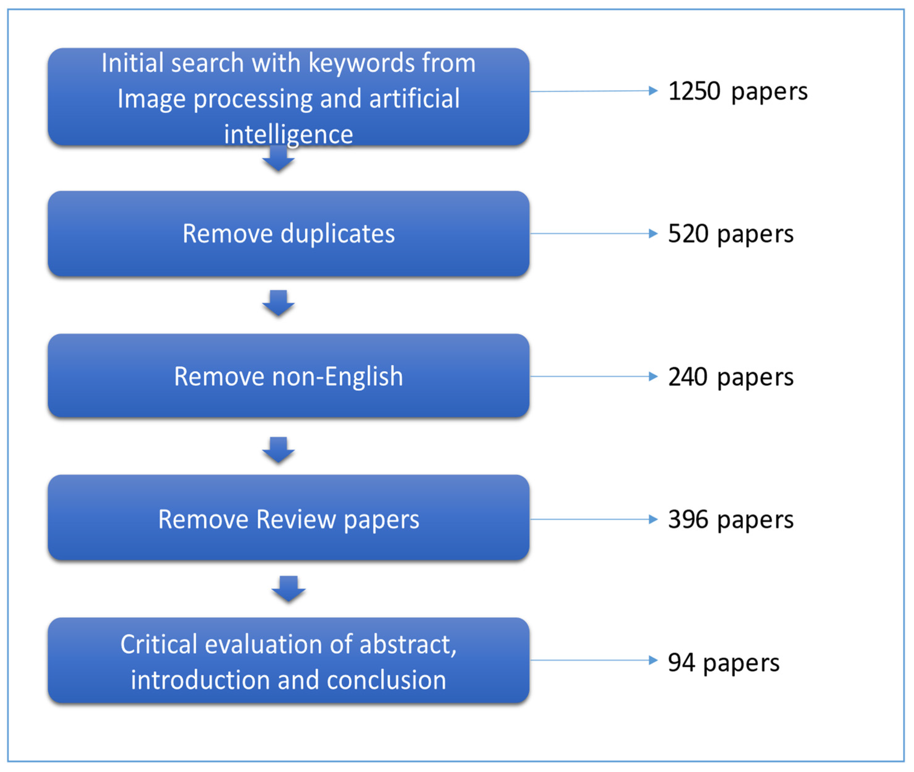
2. Materials and Methods

The aim was to assess the development in this field and how these advanced tools are facilitating post-disaster scenarios. To achieve the desired goals, top journals were searched for recent and significant work carried out in the domain. The review process was carried out in two phases, i.e., retrieving articles and screening them.
To retrieve the research articles for this study, the chosen search engines were Scopus, Google Scholar, Science Direct, Elsevier and Springer for finding the latest developments and interdisciplinary research in the field. The next step was to formulate a set of queries to be used in each of these search engines to retrieve the articles. The major aim was to fully exhaust the search database and retrieve a maximum number of articles matching our domain of interest. We used three categories of terms representing the subdomains to extract a variety of research articles. After entering the search queries, a set of articles ranked based on their relevance were retrieved. The first category of phrases was formulated to retrieve articles that proposed flood prediction models using image processing technologies that utilised multispectral sensors. The phrases were formed by using keywords related to flood prediction, which includes “flood prediction”, “flood risk analysis” and “flood hazard mapping”, along with phrases such as “image processing” and “artificial intelligence”. The second category of terms was formulated to retrieve articles that proposed flood prediction methods using these technologies. For this purpose, we used flood prediction keywords along with the keywords “edge detection”, “mining patterns from images”, “Synthetic Aperture Radar” and “Image-based flood Alarm model”. The number of articles retrieved from each category of search keywords is shown in Figure 1.
After the first phase based on article retrieval, the articles were passed through a screening phase to further narrow down the selection criteria. Four assessment criteria were defined to evaluate the articles:
  • No Duplicates
  • Time Interval: 2010–2021
  • Document Type: research article, abstract, book chapter
  • English language only
Thus, by filtering the articles based on these metrics, the most recent, applicable and unique research articles written in the English language were extracted. From the 1250 articles retrieved in the first phase, 94 articles passed all four selection criteria. Hence, this review is based on these screened articles. The number of articles from each term category, i.e., image processing, artificial intelligence and integrated approach that passed the screening phase, is shown in Figure 1. The articles were screened for duplicates, non-English articles and review papers. Around 520 papers were removed for duplicates, 240 for non-English articles and 396 for review papers. Hence, overall, 94 papers were finally collected as an output of the screening phase.
Figure 2 shows the year-wise distribution of articles retrieved from each category. It shows a significant increase in the use of image processing and artificial intelligence-based techniques for flood management as compared to integrated approaches in the past decade. On the other hand, a comparatively smaller number of articles focused on the use of image processing and artificial intelligence for flood management in a post-disaster scenario. An even smaller number of papers focused on holistic approaches for disaster management. The search was extended to include reports, magazine articles and web pages from authentic websites, thus increasing the scope and collecting a wide range of articles based on the subject matter. All the articles published before 1 January 2010 were discarded. This was to include the most recent technologies in the review. One exception to this rule was keeping some earlier papers that introduced basic concepts and definitions related to the technologies discussed in this study.

3. Results

RQ-1.
What are the latest developments in image processing for flood management in the post-disaster scenario?

3.1. Image Processing

3.1.1. Edge Detection

Edge detection techniques have been applied to measuring water levels. The major steps involve selecting a Region of Interest (ROI), applying pre-processing methods and then performing edge detection to finally compute an approximate value of the water surface levels of a water body [44,45,46]. These steps are discussed below:
  • Region of Interest: the Region of Interest (ROI) technique is used for extracting a segment of an image where several operations need to be performed. In simple words, it is similar to cropping an image to a reduced form. ROI helps in removing noise (the unwanted image) so that the process runs smoothly and effectively. Figure 3a shows an input image, Figure 3b shows the highlighted ROI and Figure 3c demonstrates the extraction of ROI from the image [47].
  • Brightness and Contrast: it is a basic method affecting the quality of images. This method makes the image bright. Brightness is directly proportional to the number of pixels in x and y coordinates and the constant á of the image. A positive value makes the image brighter and vice versa. Figure 3d shows the noise-filtered image and Figure 3e shows the output image with increased brightness.
  • Grayscale and Threshold: the greyscale image only holds the intensity information. The image is black and white textured, with black being the weakest intensity and white colour depicting a strong intensity range. Threshold, on the other hand, is a point that converts a grayscale image into a binary image. Figure 3f illustrates a grayscale image, while Figure 3g shows a binary (black and white) image.
  • Edge Detection: this algorithm helps to find out the edge points on the water surface and the point of the dam’s height. The algorithm was found helpful in determining the edge of the water. The output consists of a segmented image separating the water area from the rest of the image. The system calculates the existing water surface level by comparing the edge pixel coordinate. If the water level increases, the pixel coordinates drops resulting in altered segmentation. The system should be calibrated properly for accurate estimation of results [48]. A warning system can be established by using this method. The water surface level of any region can be calculated by processing the captured image. Moreover, the image can be spread on social media as a piece of evidence for alerting people of the upcoming disaster. Figure 3a–h shows the edge detection results on the test image.
Detection of significant landmarks from images is another method being used to analyse various features from the images to determine whether a region is flooded or not. Researchers are focusing on extracting landmarks present on the ground, such as bridges, roads, houses and buildings [48,49,50,51]. These features can be further processed using image processing techniques to aid in disaster response. For example, houses and buildings can be identified to locate stranded people. Roads and bridges can be used to identify the routes available in a certain area, which can assist in reaching and evacuating people. These features can also be processed separately for damage assessment due to a disaster and to verify the occurrence of disaster in the region. Munawar et al. [51] used isotropic surround suppression and Hough transforms for target recognition from aerial images and performed rule-based verification of strategic targets detected from these images. Recently, edge detection techniques on multispectral aerial images to mine strategic bridge locations to provide aid in disaster relief missions have been applied [51,52,53]. Table 1 summarises the methodologies using edge detection for various flood management processes.

3.1.2. Image-Based Flood Alarm Model (IFAM)

IFAM is a flood alert system. The system utilises images for monitoring rising water levels in real-time. The IFAM receives videos through digital camera sensors. The sensors are installed around rivers. The videos are processed in JPEG images. Image enhancement is completed. The flood risks are then calculated by devising modules that estimate the water level [28]. Figure 4 shows the schematic diagram of an IFAM.
IFAM utilises the image segmentation technique to remove noise and unwanted objects. The image segmentation follows several algorithms, such as point-based segmentation, edge-based segmentation, region-based segmentation and hybrid segmentation. The outside sources are likely to affect the image segmentation techniques [55,56]. These include reflection, humidity, bad environment, smoke, storm and other sources. If the outdoor environment changes, the technique would be unable to detect the flooded area and the correct boundaries of the area will not be identified [57]. Therefore, image segmentation should be coupled with flood-risk classifiers for lowering the risk level. After the image processing module, a risk detection module is generated, which informs the relevant organisation of upcoming risks [28].
During the first module of image processing, the images received from sensors are processed by converting the colour space from the Red–Green–Blue (RGB) domain to the Hue–Saturation-Value (HSV) domain [58]. The HSV colours are relevant to the Cartesian coordinate system. Histogram equalisation is applied to equalise the image colours of water and surrounded areas such as forests or land by increasing the contrast level [59]. Different parts of an image are classified into components such as buildings, rivers and other surrounding things [55]. A Region Growing (RegGro) algorithm is then applied, which is used for segmentation and creating a binary mask. A binary mask outlines the areas of water. The second module consisted of an alarm system that generates an alarm when a flood is detected. Thus, the system performs real-time flood water monitoring based on IFAM sensors installed near water bodies.
After the acquisition of images from satellite sources, the information is collected in different data sets. Data processing tools then help in processing the information, followed by database development [60]. A comparative analysis of information is carried out, which produces a draft of damage estimation accompanied by flood monitoring.

3.1.3. Post-Disaster Assessment Using UAV

Ezequiel et al. [61] proposed UAV-based aerial imagery for post-disaster assessment and monitoring of infrastructure. Collaborative research was conducted for data acquisition, path planning and processing of UAV based aerial imagery. This assists in gaining background information for making the right decisions. In the Philippines, after Typhoon Haiyan, damage estimation was carried out using initial aerial imagery. UAV-based aerial imagery assisted in relocation and rehabilitation efforts within the region. Besides damage assessment of building and infrastructure, damage to the agriculture industry was also estimated with aerial imagery and ground survey. The damage to crops was identified using aerial imagery based on normal RGB and multispectral cameras. Vegetation indices were calculated using the image processing technique, while ground-based knowledge was gathered from the field experts. An accurate estimate of damage facilitated making a decision for recovery assistance from the Government and implementing recovery plans. Table 2 summarises the latest developments in the field of image processing for flood management.
One of the basic post-disaster assessments involves the estimation of the area and volume of the flood. Several studies have applied remote sensing for computing the volume and volumetric changes of the forest areas, as a ground-based survey of patch forest is difficult to conduct [62,63,64,65]. For example, Esteban et al. [62] estimate the changes in the volume and biomass of the forest cover using remote sensing data. Two regional study areas, i.e., Spain and Norway, were selected for the study. Random Forest algorithm was used to predict forest volume or above-ground biomass using remote sensing data. Similarly, different methods such as UAV-based monitoring, tracer test analysis, UAS photogrammetry, ArcGIS, etc., have been applied for estimating flood induced changes, volumetric and topographic changes [66,67,68,69]. Akay et al. [66] conducted a two-year study on the Buyuk Menderes river basin, Turkey, to quantify and visualise flood-induced morphological changes through UAV surveys. To evaluate the change in river morphology, multi-temporal orthomosaics and digital surface models (DSMs) were constructed using the Structure from Motion (SfM) technique. Diachronic spatial and volumetric changes in the meander structures were assessed by the Digital Shoreline Analysis System (DSAS) and Digital Elevation Model (DEM) of Difference (DoD) tools. Aerial and volumetric changes of the river bank were achieved using the SfM photogrammetry technique through UAV-derived imagery. Hence, the processing time of the technique is important to consider when applying for the flood monitoring system. Additionally, the accuracy of the image processing technique for predicting the flood area needs to be evaluated. The comparison of the techniques and the one with the best performance need to be considered for implementation in the system for the monitoring. Even though image processing has been extensively used for flood detection and finding safe routes in the affected region, the technique used independently has found to be less accurate due to various factors that limit its higher uptake. These factors are mainly environmental pollution, clouds, contrast and brightness that reduces the quality of the images. Besides these factors, it is difficult to obtain consistent results with a different set of images. To overcome these issues, machine learning algorithms can be applied to improve datasets, train the models and achieve higher accuracy and prediction.
RQ-2.
What is the latest techniques for flood management based on artificial intelligence in a post-disaster scenario?

3.2. Artificial Intelligence (AI)

AI methods are frequently being used to deal with several flood-related problems. These include flood prediction, flood hazard analysis, flood detection, mapping flood-prone regions and assessing the damage of infrastructure components after the flood. Table 3 summarises the most recent techniques based on AI for flood management. Each of these methods has been discussed in detail in this section [67].
A tool referred to as the Qatar Computing Research Institute (QCRI) was developed in Qatar for managing disasters. It was created by the Qatar Foundation to educate and make people more aware of responding to disasters and emergencies. QCRI aims to facilitate volunteer workers and disaster management authorities. This tool has a built-in AI component that detects disaster-related tweets and text from any given data. It then formulates an instant solution to recover from the calamity [68].
1Concern is another AI-based tool for disaster management. During a flood-related emergency, this tool forms a rich image of the scenario. Emergency management organisations use this image to further examine and probe the situation [69]. Based on their analysis, these centres immediately provide relief items to the disaster victims and initiate rescue operations. The tool has a planning module that maps disaster-prone regions. After identifying these regions, people can be immediately evacuated to save their lives. Hence, this software provides pre-disaster disaster risk assessment as well as aids post-disaster response. This tool has been implemented in up to 163,696 square miles region and has saved 39 million people [67,68]. It has also been used to examine 11 million infrastructure components in disaster-hit areas.
BlueLine Grid is another disaster management tool that has been created by a police commissioner in the USA. To provide aid in rescue operations after a disaster, this tool works as a portable communication platform [64]. It also maintains a connection between relief workers, police and security squads by connecting them in one network. This network allows the communication of data in sound and text formats and provides location and group services. The location services allow users to locate people and rescue workers in nearby areas. Hence, this tool provides instant response to disasters and emergencies [68].
In India, AI-based systems are evolving. A tool using Google Maps and Google Search has been developed by Google for flood forecasting and warning. Rainfall and past flood data are used to train the AI model [69]. This system simulates floods based on the acquired weather and rainfall data. It has also been used to forecast floods in urban areas. Research conducted at the University of Dundee, United Kingdom, used this tool to determine the urban flooding rate using crowd-sourced data collected from social media platforms [18].
Recently, more work is being directed towards applying AI and machine learning technologies for disaster management. Chen et al. [14] applied machine learning along with the Random Forest method for risk evaluation of floods. The main flood prediction methods are Random Forest, Decision Trees (DT) and Lazy method. The training data consists of Big data collected from the weather data from past flood events. A Flood Data Aggregation Tool (FDAT) is developed using MATLAB to extract features to be used for training. The main aim is to enable the AI models to learn from the previous flood incidents, identify the flood behaviours and understand patterns in the data to predict future flood incidents. This would help in preventing the destruction, reducing fatalities and building resilience against such disasters.
Chapi et al. proposed a hybrid approach to generate flood susceptibility maps. The model is called “Bagging LMT” as it combines bagging ensemble with a logistic model tree (LMT) [24]. The target region was Haraz, Northern Iran. Images from this region were used to build the image dataset. Eleven flood-conditioning factors were included in the dataset. These factors were shortlisted by using an information gain ratio method along with average merit (AM) calculation. Results were compared with the LMT model, logistic regression, Random Forest and Bayesian logistic regression to prove that it outperformed these models in performance. The system achieved an overall accuracy and precision of 95.5%, making it highly effective and reliable for flood susceptibility assessment.
In the literature, the researchers have attempted to overcome the performance limitations of various existing machine learning models by incorporating statistical methods into them. This approach is used by Tehrany, Pradhan [16], who developed an ensemble model using frequency ratio (FR) along with SVM. A spatial model for flood prediction was built using this method [16]. Several conditioning factors were identified, and a numerical value was estimated using the proposed algorithm that represented the dependency between the incidence of flood and these conditioning factors. FR is calculated for each conditioning factor, and after that, the normalised values of weights within the range [0,1] were obtained by applying the given formula:
Y m = y m y m i n y m a x y m i n
In Equation (1), Ym denotes the normalised values of ym. The minimum value of yj is represented by ymin, and the maximum value is denoted by ymax. The conditioning factors are allocated the weights determined by this method. The resultant conditioning factors are applied to an SVM-based method to determine the link between each of the conditioning factors and the occurrence of a flood.
ANN is among the most widely used machine learning models to forecast disasters with good performance. There are three main layers in an ANN model, which are referred to as input, hidden and output layers. Only one or two hidden layers are present in a typical ANN. Liu et al. [70] combined Stacked Autoencoders and Back Propagation Neural Network (SAE-BPNN) to develop a flood prediction model. An autoencoder extracts non-linear features from input image data using unsupervised learning [70]. A stacked autoencoder has many layers of thin autoencoders forming a neural network. Each layer’s output is applied to the subsequent layer as input. The model used multiple SAE-BP modules. The data is classified into several groups using k-means clustering. Each SAE-BP module would simulate its corresponding data class. The results demonstrated by this model surpassed the performance of all benchmarks chosen for the study. Let yi((m)) be the activation function of the ith unit in layer m. The output [x]mi of this unit is applied as input to the next. The weights connecting units in various autoencoder layers are denoted by W. The mathematical function specifying encoding for autoencoder is:
y ( m ) = f ( x ( m ) )
Multiple conditioning factors causing floods can be used to identify flood-prone areas. Tehrany, Pradhan [16] used a set of these factors for flood susceptibility mapping. Their model used the weights of evidence (WoE) method to find the impact of each conditioning factor on the flood incidents along with a bivariate statistical analysis (BSA) technique [16]. The positive and negative weights are calculated to find the WoE values using the following formulas:
w j + = l n P { B | A } P { B | A }
In Equations (2) and (3), ln denotes the natural log, whereas P is the probability function. The variables B, B ̅, A and A ̅ represent the absence and presence of the conditioning factors. The conditioning factors are again classified using the acquired weights. Then, an SVM model was used to find the relationship between each conditioning factor and the occurrence of a flood. Results demonstrated improved performance over independent usage of BSA and SVM.
Statistical methods have been employed frequently in the literature to improve the performance of machine learning models. Shafizadeh-Moghadam et al. [30] experimented with eight machine learning and statistical methods for flood prediction [30]. They proposed seven new ensemble models by analysing the individual working of these methods. Among the machine learning models, Boosted Regression Trees (BRT) demonstrated the highest performance when independently used, with an Area Under Curve (AUC) equal to 0.975. Among ensemble techniques, the Emmedian method showed the highest performance with AUC = 0.976. This method calculated the median values of probabilities across the predictions.
Figure 5 shows the flood mapping results on an input multispectral aerial image. The system classifies the flooded (Red) and non-flooded (Blue) regions and highlights them using different colours in the output so that the rescue workers can easily distinguish between them.
Table 3 shows the comparison results of the most recent, state of the art flood management and detection models that used AI. The current research shows a wide range of articles focusing on the standard AI and machine learning techniques such as Random Forest, Bayesian Linear Model, ANN, Decision Trees and SVM [71]. Most techniques focused on ensemble and hybrid approaches, which are known to boost performance outcomes. Integrating results of multiple independent classifiers form an ensemble model, while a hybrid model uses two or more classifiers to produce an output. A rising trend has been in the use of statistical analysis along with machine learning. Statistical methods such as FR and BSA have been incorporated with machine learning models such as SVM, demonstrating a noticeable improvement in results. Other statistical methods such as EMmean and EMmedian have been observed in the literature for solving the flood prediction problem, demonstrating results at par or better than the standard machine learning or AI techniques [72].
The researchers have used various metrics to assess the performance of their techniques; the most frequent one is the accuracy, which is simply the percentage of correct detections. Other measures include AUC, success rate and Deterministic coefficient (DC). Most of the techniques have limitations arising from the data-based restrictions [73]. The models using conditional factors needed to select these factors from a large pool of flood data. This required careful feature selection and extraction, as the most influential factors, which are contributing the most to the occurrence of floods, needed to be selected. Other data-related problems include an imbalance in data distribution, the presence of unidentified variables in data and ambiguity in selecting parameters for the system. Hence, most models are found to be highly dependent on the input parameters and data either to be used in training, testing or just analysis and the major concerns of researchers about their proposed system were most frequently related to the input data. One possible way to solve this issue is to use deep learning methods, which have an inherent ability to cope with unstructured data and perform feature extraction automatically. Additionally, the use of deep learning to tackle the problem of flood management was found to be rare, despite its increased usage in image classification and segmentation problems. This indicates the need to investigate the models from this domain for flood detection and mapping tasks.
Some works have also been conducted on the generative adversarial network (GAN) that enables to capture high-quality images and provide support in models for estimation of water levels, analysing surface water, losses in wetlands and river winding. With the application of GAN, the data sets can be improved, and the models could be trained well. In the study carried out by [74], a repository was developed for the overhead river images for training purposes. An augmentation was summarised, and Progressive Growing GAN (PGGAN) was implemented to train small resolutions images and develop high-resolution images. Some limitations have been observed with conventional GAN resulting in high computational time and gradient issues that PGGAN overcomes. GAN is the primary system for the generation of unsupervised data [68]. The network of a generator and discriminator work in contrast to each other, where the generator creates realistic images and fools the discriminator to not distinguish between the real and fake images. Thus, the shortage of data was overcome with the application of GAN, and better outcomes of the models were achieved.
Data mining and social sensing with the application of Natural Language Processing (NLP) is an emerging technology to extract and assess social media data for any disaster event [69,70,71]. Social media provides current information about the event and keep the public up to date about the oncoming hazard. This data will facilitate the prediction of the emergency scenario and understand human behaviour by assessing underline patterns of media users. Social sensing has advantages over field surveys and interviews, as it gathers data from the public, not directly from the disaster responders, provides real-time data of the disaster scenario and facilitate in making a timely decision for mitigating the disaster and informing the public about evacuation plans [75].
Another method of data collection and analysis is through crowdsourcing, which is a cost-effective and time-efficient method. The performance of crowdsourcing can be significantly enhanced with the application of AI and machine learning methods or flood management, as it provides access to good quality structured data for training the algorithms. Crowdsourcing relates to data collection and decision-making approach based on the information gathered [76,77]. For disaster management, crowdsourcing aims to collect and analyse the data. It facilitates gathering firsthand information about disaster situations, sharing knowledge on online platforms. It processes data through image labelling, putting coordinates, tagging and categorising, such as labelling of damaged infrastructure on images collected through remote sensing. This results in the generation of structured and precise data for input into machine learning models and making real-time decisions [78,79,80].

4. Discussion

RQ-3.
What are the existing gaps in the selected technologies for flood management?
The image processing technique has been widely applicable for flood monitoring, identifying routes and landmarks. 3D geodetic data for flood analysis is essential for flood management. A large number of geodetic, photogrammetric and remote sensing techniques are available to collect 3D data as it provides more in-depth information and provides an opportunity to extract digital terrain and surface models [78]. Advanced techniques such as Laser scanning—LIDAR (Light Detection and Ranging) and UAV (Unmanned Aerial Vehicle) have been investigated for conducting surveys. The gathered information can be useful to analyse geodetic information on the exiting environment and the impacts of potential disaster, its impacts on the area and the damage caused. These technologies help to collect a large amount of data in a short time with high accuracy and can be used for future analysis. These techniques allow higher data accuracy which is achieved through high resolution of the collected data having higher data density. With the advancement in technology, compact devices are being built with platforms that collect data. Affordable prices make it more attractive to the end-user [78,79,80,81]. However, there is a certain limitation of image processing that hinders the wider uptake of this technique and achievement of the required outcomes. Often, the quality of the images is marginalised due to various factors, and the obtained results are less accurate. These factors may include brightness, contrast, environmental pollution, clouds and dust particles. Different correction features such as radiometric, geometric corrections and bad line replacement are applied to obtain desired results. It is often difficult to obtain consistent results and the required quality of the image with each test image due to several interferences and limitations of this technique. It is often observed that pre-defined algorithms or scripts may work fine for a certain set of images while it may not be able to process other sets of images due to inconsistencies that may be due to various factors [82,83]. To address these issues, various AI and machine learning tools can be adopted. Higher accuracy and reliability could be obtained by utilising large datasets for training a prediction model. Different sensors are used to capture feature and mapping applications. A holistic approach could be carried out to implement image processing along with other techniques so that the limitations are overcome and better results could be obtained. For example, Munawar et al. [84] applied a novel approach to image processing and machine learning for post-disaster management. The researchers focused on identifying the floods using machine-based analysis of images. The developed model used a holistic approach for incorporating image processing and machine learning, which was computationally efficient and was able to speed up the training process. The improved images were used by the classifier for training purposes and updating core algorithms. The model was able to classify flooded and non-flooded images with a timely response for providing the aid [84]. Furthermore, hyperspectral imagery has been widely used instead of multispectral imagery to differentiate mixed pixel images. Another technique of image fusion has also been used often to improve classification instead of individual sensors, which may be inconsistent.
RQ-4.
How can the authorities improve the existing flood management operation with cutting-edge technologies?
Based on the extensive review, it is suggested that the authorities should adopt image processing techniques in tandem with machine learning. Machine learning will enable the processing of large datasets, and train prediction models which can implement intelligence as per the training models. This would give higher accuracy of the obtained results [82,83,84]. As per the extensive review carried out for this study, numerous technologies are currently being used involving artificial intelligence and machine learning; however, not much work is being carried out to integrate technologies for enhanced management of floods. To improve the existing systems, the authorities can map the flooded region either using aerial imagery through satellites or using UAVs allocated to the affected regions. The UAV route can be optimised to provide maximum area coverage of the area in minimum time and cost [83] (Figure 6). The UAV swarm will collect the images of the region and provide the gathered data to the control centre [85,86,87,88]. Recently, Albani et al. [85] applied a macroscopic model for monitoring an area using UAVs. Parametriasition was proposed for efficient allocation of the UAVs; abstract multiple-agent simulations were conducted to deploy UAVs in multiple areas, and simulation of UAV swarm was carried out for mapping the areas. Similarly, Venturini et al. [86] proposed a Reinforcement Learning (RL) approach to deal with large swarms allocating to non-uniform distributions of targets. It was found in the study that training the UAVs for specific scenario assist in adapting to any new scenario with the least amount of training. The real-time data collected from drones during flood situations could be analysed using pre-processing methods. Also, with the application of edge detection, it could help extract the features and label the images. The extracted images are fed into machine learning algorithms for training the models. Shortage of data could be an obstacle for efficiently training the models. To overcome these issues, authorities can apply GAN [89,90,91]. The generative models can be successfully applied for producing realistic images, thus assisting in generating more data. The data set can then be processed to develop flood maps, evacuation plans and for delivering relief goods to the victims [92,93,94,95,96,97,98]. A framework is proposed based on image processing and artificial intelligence learning (Figure 7).
The authorities can use integrated technologies such as cloud computing, image processing and artificial intelligence for gathering real-time information for finding routes to reach the affected regions. These technologies have the potential for improving the response in real-time. With the help of images from the disaster site, the authorities can develop maps for the obstacles and other hurdles that are limiting the relief operation to be carried out efficiently [99,100,101,102,103,104,105]. In Baldazo et al. [105], researchers monitored floods by applying Deep Q-Networks (DQN) as the optimisation strategy for the trajectory planning; agents were trained over simulated floods in procedurally generated terrain and demonstrated good performance with two different reward schemes. Similarly, Hildmann et al. [106] investigated the use of UAVs as Mobile Sensing Platforms (MSPs) for Disaster Response, Civil Security and Public Safety. The wider application and uptake of the technology can be enhanced by addressing the challenges for individual UAVs and a swarm of UAVs. The increase in the application of UAVs will enhance the rise of UAV swarms.
Furthermore, social media is a good platform to disseminate information and altering the community. With the use of smartphones, information dissemination has been accelerated. Instead of using traditional cloud computing-based disaster management methods, various AI-based techniques can help the authorities with data offloading and real-time detection of disasters. In an emergency, creating awareness among the community and providing timely information is critical in saving the lives of people [107]. These technologies can help the authorities in disaster preparedness, planning and decision making. Flood prediction can be enhanced by using infrared sensors assessing the movement of the individuals. The information gathered by the sensors can be analysed and forwarded to the concerned departments to take necessary actions. Optimising the route and floor plan simulation can assist in finding the shortest route for escaping the emergency. The developed models and sensors must be able to work in dynamic environments and handle different crises or be complementary to each other [107]. The inclusion of artificial intelligence will capture human intelligence and behaviours in conditions that have not been considered before. In a disaster response, AI can assist in collecting real-time data from social media or public platforms and analyse the data based on algorithms using different classification methods. This can classify informative and non-informative data during a disaster event. Authorities can apply the shortest path algorithm to come up with the best evacuation plan and guide their relief teams. Methods have been developed for working in a static environment with no requirement to manage automatic congestion [108]. Moreover, the use of big data can accelerate response time and save human lives. The escape route patterns during a disaster event can be explored using spatiotemporal analytics of social media, thus providing useful real-time information, as survey data may not be accessible during a crisis. A deep learning approach can be used by the relief department to analyse mobility patterns, and with the help of a simulator, human behaviours can be predicted as per the situation. Furthermore, algorithms with GPUs can predict traffic patterns and can effectively manage traffic using real-time data. Hence, there are different technologies, algorithms and models which work in dynamic environments, assess the risk and help in decision making. A better understanding and application of these technologies by the emergency departments can fasten up the relief operations.

5. Conclusions

Advanced technologies are essential for maintaining communication, finding the safest route and providing services to stranded people in a flood event. Comparative analysis of different technologies is essential to understand the shortcomings of each and how to address them using an integrative approach. Important resources are required by the victims to survive during the disaster, and time is critical. With the application of the latest tools, the safest routes for evacuation can be determined in advance for regions where the probabilities of exceedance of the flood hazard are anticipated. Image processing data can provide useful information about the extent of the damage to the roads, bridges and locate a possible route to reach the victims. It can also help to detect damage to buildings and infrastructure. Detection of significant landmarks from images is another method being used to analyse various features from the images to determine whether a region is flooded or not. Furthermore, AI methods are frequently used to deal with several flood-related problems, including flood prediction, flood hazard analysis, flood detection, mapping flood-prone regions and assessing the damage of infrastructure components after the flood. AI-based algorithms can optimise various functions and minimise computational time to obtain the desired outcome under any crisis. The images captured from the disaster site can be feed into the AI algorithms to develop maps for identifying any obstacles and hurdles that are limiting the relief operation to be carried out efficiently. AI-based techniques can help the authorities with data offloading and real-time detection of natural events. Futuristic communities can be imagined with the use of AI-based sensors gathering information and giving early warning to minimise the damage. The application of these technologies should be carried out at a large scale considering any unforeseeable events. These technologies could be extended for advising developmental initiatives, improving the existing capacity for flood management and minimising the adverse effects of disasters. Thus, integration of emerging technologies, networks, services and applications can enhance risk reduction and prepare the community for any situation. Application of these technologies at different phases of disaster and keeping dynamicity in consideration can assist in preparing for any oncoming disaster such as bushfires, earthquakes, etc. Real-time data acquisition can help in evacuation plans and simulating enhanced evacuation models, thus helping the authorities in disaster preparedness, planning and decision making.

Author Contributions

Conceptualization, H.S.M., A.W.A.H., M.J.T. and S.T.W.; methodology, H.S.M. and A.W.A.H.; investigation, H.S.M., A.W.A.H., M.J.T., A.S. and S.T.W.; writing—original draft preparation, H.S.M. and A.W.A.H.; writing—review and editing, A.W.A.H. and M.J.T.; supervision, A.W.A.H., M.J.T., A.S. and S.T.W. All authors have read and agreed to the published version of the manuscript.

Funding

This research received no external funding.

Institutional Review Board Statement

Not applicable.

Informed Consent Statement

Not applicable.

Data Availability Statement

No new data were created or analyzed in this study. Data sharing is not applicable to this article.

Conflicts of Interest

The authors declare no conflict of interest.

References

  1. Tsai, M.-H.; Yang, C.-H.; Chen, J.Y.; Kang, S.-C. Four-Stage Framework for Implementing a Chatbot System in Disaster Emergency Operation Data Management: A Flood Disaster Management Case Study. KSCE J. Civ. Eng. 2021, 25, 503–515. [Google Scholar] [CrossRef]
  2. Anbarasan, M.; Muthu, B.; Sivaparthipan, C.B.; Sundarasekar, R.; Kadry, S.; Krishnamoorthy, S.; Dasel, A.A. Detection of flood disaster system based on IoT, big data and convolutional deep neural network. Comput. Commun. 2020, 150, 150–157. [Google Scholar] [CrossRef]
  3. Gupta, K. Challenges in developing urban flood resilience in India. Philos. Trans. R. Soc. A Math. Phys. Eng. Sci. 2020, 378, 20190211. [Google Scholar] [CrossRef] [Green Version]
  4. Sintha, E.O.M.; Suryadi, B.; Syafari, M.R. Performance Assessment of Local Government Organizations on Flood Disaster Prevention and Preparedness in Gunung Mas Regency. Sch. Int. J. Law Crime Justice 2020, 3, 458–462. [Google Scholar] [CrossRef]
  5. Kankanamge, N.; Yigitcanlar, T.; Goonetilleke, A. Kamruzzaman Determining disaster severity through social media analysis: Testing the methodology with South East Queensland Flood tweets. Int. J. Dis. Risk Reduct. 2020, 42, 101360. [Google Scholar] [CrossRef]
  6. Wu, Z.; Shen, Y.; Wang, H.; Wu, M. Urban flood disaster risk evaluation based on ontology and Bayesian Network. J. Hydrol. 2020, 583, 124596. [Google Scholar] [CrossRef]
  7. Karunarathne, A.Y.; Lee, G. The geographies of the dynamic evolution of social networks for the flood disaster response and recovery. Appl. Geogr. 2020, 125, 102274. [Google Scholar] [CrossRef]
  8. Oktari, R.S.; Munadi, K.; Idroes, R.; Sofyan, H. Knowledge management practices in disaster management: Systematic review. Int. J. Dis. Risk Reduct. 2020, 51, 101881. [Google Scholar] [CrossRef]
  9. Wu, Z.; Shen, Y.; Wang, H.; Wu, M. An ontology-based framework for heterogeneous data management and its application for urban flood disasters. Earth Sci. Inform. 2020, 13, 377–390. [Google Scholar] [CrossRef]
  10. Gautam, A.; Sit, M.; Demir, I. Realistic River Image Synthesis using Deep Generative Adversarial Networks. arXiv 2020, arXiv:2003.00826. [Google Scholar]
  11. Zhang, J.; Zhou, C.; Xu, K.; Watanabe, M. Flood disaster monitoring and evaluation in China. Glob. Environ. Chang. Part B Environ. Hazards 2002, 4, 33–43. [Google Scholar] [CrossRef]
  12. Iqbal, U.; Perez, P.; Li, W.; Barthelemy, J. How computer vision can facilitate flood management: A systematic review. Int. J. Dis. Risk Reduct. 2021, 53, 102030. [Google Scholar] [CrossRef]
  13. Matgen, P.; Schumann, G.; Henry, J.-B.; Hoffmann, L.; Pfister, L. Integration of SAR-derived river inundation areas, high-precision topographic data and a river flow model toward near real-time flood management. Int. J. Appl. Earth Obs. Geoinf. 2007, 9, 247–263. [Google Scholar] [CrossRef]
  14. Chen, J.; Li, Q.; Wang, H.; Deng, M. A Machine Learning Ensemble Approach Based on Random Forest and Radial Basis Function Neural Network for Risk Evaluation of Regional Flood Disaster: A Case Study of the Yangtze River Delta, China. Int. J. Environ. Res. Public Health 2019, 17, 49. [Google Scholar] [CrossRef] [PubMed] [Green Version]
  15. Elhag, M.; Abdurahman, S.G. Advanced remote sensing techniques in flash flood delineation in Tabuk City, Saudi Arabia. Nat. Hazards 2020, 103, 3401–3413. [Google Scholar] [CrossRef]
  16. Tehrany, M.S.; Pradhan, B.; Jebur, M.N. Flood susceptibility analysis and its verification using a novel ensemble support vector machine and frequency ratio method. Stoch. Environ. Res. Risk Assess. 2015, 29, 1149–1165. [Google Scholar] [CrossRef]
  17. Dawson, D.A.; Vercruysse, K.; Wright, N. A spatial framework to explore needs and opportunities for interoperable urban flood management. Philos. Trans. R. Soc. A Math. Phys. Eng. Sci. 2020, 378, 20190205. [Google Scholar] [CrossRef] [Green Version]
  18. Pouyanfar, S.; Tao, Y.; Sadiq, S.; Tian, H.; Tu, Y.; Wang, T.; Shyu, M.L. Unconstrained flood event detection using adversarial data augmentation. In Proceedings of the International Conference on Image Processing (ICIP), Taipei, Taiwan, 22–25 September 2019; pp. 155–159. [Google Scholar]
  19. Saravi, S.; Kalawsky, R.; Joannou, D.; Rivas-Casado, M.; Fu, G.; Meng, F. Use of Artificial Intelligence to Improve Resilience and Preparedness Against Adverse Flood Events. Water 2019, 11, 973. [Google Scholar] [CrossRef] [Green Version]
  20. Hong, H.; Tsangaratos, P.; Ilia, I.; Liu, J.; Zhu, A.-X.; Chen, W. Application of fuzzy weight of evidence and data mining techniques in construction of flood susceptibility map of Poyang County, China. Sci. Total Environ. 2018, 625, 575–588. [Google Scholar] [CrossRef]
  21. Lütjens, B.; Leshchinskiy, B.; Requena-Mesa, C.; Chishtie, F.; Díaz-Rodriguez, N.; Boulais, O.; Piña, A.; Newman, D.; Lavin, A.; Gal, Y.; et al. Physics-informed GANs for coastal flood visualization. arXiv 2020, arXiv:2010.08103. [Google Scholar]
  22. Ahmad, D.; Afzal, M. Household vulnerability and resilience in flood hazards from disaster-prone areas of Punjab, Pakistan. Nat. Hazards 2019, 99, 337–354. [Google Scholar] [CrossRef]
  23. Syifa, M.; Park, S.J.; Achmad, A.R.; Lee, C.-W.; Eom, J. Flood Mapping Using Remote Sensing Imagery and Artificial Intelligence Techniques: A Case Study in Brumadinho, Brazil. J. Coast. Res. 2019, 90, 197–204. [Google Scholar] [CrossRef]
  24. Chapi, K.; Singh, V.P.; Shirzadi, A.; Shahabi, H.; Bui, D.T.; Pham, B.T.; Khosravi, K. A novel hybrid artificial intelligence approach for flood susceptibility assessment. Environ. Model. Softw. 2017, 95, 229–245. [Google Scholar] [CrossRef]
  25. Chiba, Y.; Shaw, R.; Prabhakar, S. Climate change-related non-economic loss and damage in Bangladesh and Japan. Int. J. Clim. Chang. Strat. Manag. 2017, 9, 166–183. [Google Scholar] [CrossRef]
  26. Handayani, W.; Chigbu, U.E.; Rudiarto, I.; Putri, I.H.S. Urbanization and Increasing Flood Risk in the Northern Coast of Central Java—Indonesia: An Assessment towards Better Land Use Policy and Flood Management. Land 2020, 9, 343. [Google Scholar] [CrossRef]
  27. Vidal, S.; Richaud, B.; Hansen, F.; Courtigne, J. Flood Forecast Tool to Help Dam Management from France to Thailand. In Advances in Hydroinformatics; Springer: Singapore, 2020; pp. 427–435. [Google Scholar]
  28. Tseng, C.-H.; Chen, L.-C.; Wu, J.-H.; Lin, F.-P.; Sheu, R.-K. An automated image dehazing method for flood detection to improve flood alert monitoring system. J. Natl. Sci. Found. Sri Lanka 2018, 46, 329. [Google Scholar] [CrossRef]
  29. Munawar, H.S.; Zhang, J.; Li, H.; Mo, D.; Chang, L. Mining multispectral aerial images for automatic detection of strategic bridge locations for disaster relief missions. In Proceedings of the 23rd Pacific-Asia Conference on Knowledge Discovery and Data Mining, Macau, China, 14–17 April 2019; Springer: Cham, Switzerland, 2019; pp. 189–200. [Google Scholar]
  30. Shafizadeh-Moghadam, H.; Valavi, R.; Shahabi, H.; Chapi, K.; Shirzadi, A. Novel forecasting approaches using combination of machine learning and statistical models for flood susceptibility mapping. J. Environ. Manag. 2018, 217, 1–11. [Google Scholar] [CrossRef] [Green Version]
  31. Widiasari, I.R.; Nugroho, L.E. Deep learning multilayer perceptron (MLP) for flood prediction model using wireless sensor network based hydrology time series data mining. In Proceedings of the 2017 International Conference on Innovative and Creative Information Technology (ICITech), Salatiga, Indonesia, 2–4 November 2017; pp. 1–5. [Google Scholar]
  32. Gold, C.; Sollich, P. Model selection for support vector machine classification. Neurocomputing 2003, 55, 221–249. [Google Scholar] [CrossRef] [Green Version]
  33. Anusha, N.; Bharathi, B. Flood detection and flood mapping using multi-temporal synthetic aperture radar and optical data. Egypt. J. Remote Sens. Space Sci. 2020, 23, 207–219. [Google Scholar] [CrossRef]
  34. Gimenez-Maranges, M.; Breuste, J.; Hof, A. Sustainable Drainage Systems for transitioning to sustainable urban flood management in the European Union: A review. J. Clean. Prod. 2020, 255, 120191. [Google Scholar] [CrossRef]
  35. Donratanapat, N.; Samadi, S.; Vidal, J.M.; Tabas, S.S. A national scale big data analytics pipeline to assess the potential impacts of flooding on critical infrastructures and communities. Environ. Model. Softw. 2020, 133, 104828. [Google Scholar] [CrossRef]
  36. Cao, C.; Xu, M.; Kamsing, P.; Boonprong, S.; Yomwan, P.; Saokarn, A. Flooding Identification by Vegetation Index. In Environmental Remote Sensing in Flooding Areas; Springer: Singapore, 2021; pp. 29–44. [Google Scholar]
  37. Mohanty, M.P.; Nithya, S.; Nair, A.S.; Indu, J.; Ghosh, S.; Bhatt, C.M.; Rao, G.S.; Karmakar, S. Sensitivity of various topographic data in flood management: Implications on inundation mapping over large data-scarce regions. J. Hydrol. 2020, 590, 125523. [Google Scholar] [CrossRef]
  38. Mishra, A.; Arya, D.S. Development of Decision Support System (DSS) for Urban Flood Management: A Review of Methodologies and Results. In World Environmental and Water Resources Congress 2020: Water, Wastewater, and Stormwater and Water Desalination and Reuse; American Society of Civil Engineers: Reston, VA, USA, 2020; pp. 60–72. [Google Scholar]
  39. Singh, G.; Pandey, A. Mapping Punjab Flood using Multi-temporal Open-Access Synthetic Aperture Radar Data in Google Earth Engine. In Hydrological Extremes; Springer: Cham, Switzerland, 2021; pp. 75–85. [Google Scholar]
  40. Dai, R.; Fan, Z.; Pan, Z. A Virtual Reality Training System for Flood Security. In Transactions on Edutainment XVI; Springer: Berlin/Heidelberg, Germany, 2020; pp. 126–134. [Google Scholar]
  41. Pradeep, R.M.M.; Wijesekera, N.T.S. Incorporating stakeholder concerns in Land Information Systems for urban flood management. Array 2020, 8, 100037. [Google Scholar] [CrossRef]
  42. Bhadra, T.; Chouhan, A.; Chutia, D.; Bhowmick, A.; Raju, P.L.N. Flood Detection Using Multispectral Images and SAR Data. In International Conference on Machine Learning, Image Processing, Network Security and Data Sciences; Springer: Singapore, 2020; pp. 294–303. [Google Scholar]
  43. Gan, J.L.; Zailah, W. Water Level Classification for Flood Monitoring System Using Convolutional Neural Network. In Proceedings of the 11th National Technical Seminar on Unmanned System Technology 2019, Kuantan, Malaysia, 2–3 December 2019; Springer: Singapore, 2021; pp. 299–318. [Google Scholar]
  44. Wing, O.E.J.; Pinter, N.; Bates, P.D.; Kousky, C. New insights into US flood vulnerability revealed from flood insurance big data. Nat. Commun. 2020, 11, 1444. [Google Scholar] [CrossRef] [Green Version]
  45. Juan, A.; Gori, A.; Sebastian, A. Comparing floodplain evolution in channelized and unchannelized urban watersheds in Houston, Texas. J. Flood Risk Manag. 2020, 13, e12604. [Google Scholar] [CrossRef]
  46. Gaya, C.O. Application of GIS and Remote Sensing in Flood Management in the Lake Victoria Basin. Ph.D. Thesis, JKUAT-COETEC, Jomo Kenyatta University of Agriculture and Technology, University in Juja, Juja, Kenya, 2020. [Google Scholar]
  47. Yeum, C.M.; Choi, J.; Dyke, S.J. Automated region-of-interest localization and classification for vision-based visual assessment of civil infrastructure. Struct. Health Monit. 2018, 18, 675–689. [Google Scholar] [CrossRef]
  48. Supriyanti, R.; Suwitno, S.; Ramadhani, Y.; Widodo, H.B.; Rosanti, T.I. Brightness and Contrast Modification in Ultrasonography Images Using Edge Detection Results. TELKOMNIKA Telecommun. Comput. Electron. Control 2016, 14, 1090. [Google Scholar] [CrossRef] [Green Version]
  49. Smith, K.; Berry, R.; Clarke, L.E. Exploring the potential of Google Earth as a communication and engagement tool in collaborative Natural Flood Management planning. Geogr. J. 2019, 186, 171–185. [Google Scholar] [CrossRef]
  50. Lioi, B.; Gioia, A.; Totaro, V.; Balacco, G.; Iacobellis, V.; Chiaia, G. Coupled Use of Hydrologic-Hydraulic Model and Geomorphological Descriptors for Flood-Prone Areas Evaluation: A Case Study of Lama Lamasinata. In Proceedings of the International Conference on Computational Science and Its Applications, Cagliari, Italy, 1–4 July 2020; Springer: Cham, Switzerland, 2020; pp. 607–619. [Google Scholar]
  51. Munawar, H.S.; Maqsood, A. Isotropic surround suppression based linear target detection using hough transform. Int. J. Adv. Appl. Sci. 2017, 4, 37–42. [Google Scholar] [CrossRef]
  52. Kornfeld, J.; Svara, F.; Wanner, A.A. Image processing for volume electron microscopy. In Volume Microscopy; Humana: New York, NY, USA, 2020; pp. 245–262. [Google Scholar]
  53. Wu, J.H.; Tseng, C.H.; Chen, L.C.; Lo, S.W.; Lin, F.P. Automated image identification method for flood disaster monitoring in riverine environments: A case study in Taiwan. In Proceedings of the AASRI International Conference on Industrial Electronics and Applications (IEA 2015), London, UK, 27–28 June 2015; pp. 27–28. [Google Scholar]
  54. Jacinth, J.; Saravanan, S.; Abijith, D. Integration of SAR and multi-spectral imagery in flood inundation mapping–a case study on Kerala floods 2018. ISH J. Hydraul. Eng. 2020, 1–11. [Google Scholar] [CrossRef]
  55. Puno, G.R.; Puno, R.C.; Maghuyop, I.V. Two-dimensional flood model for risk exposure analysis of land use/land cover in a watershed. Glob. J. Environ. Sci. Manag. 2021, 7, 225–238. [Google Scholar]
  56. Wagenaar, D.; Curran, A.; Balbi, M.; Bhardwaj, A.; Soden, R.; Hartato, E.; Sarica, G.M.; Ruangpan, L.; Molinario, G.; Lallemant, D. Invited perspectives: How machine learning will change flood risk and impact assessment. Nat. Hazards Earth Syst. Sci. 2020, 20, 1149–1161. [Google Scholar] [CrossRef]
  57. Said, A.; Shaat, O.; Su, P.H.; Bogden, P.; Kraig, R.; Bosch, M. Understanding Flooding Detection Using Overhead Imagery-Lessons Learned. In International Symposium on Visual Computing; Springer: Cham, Switzerland, 2020; pp. 696–706. [Google Scholar]
  58. Karamuz, E.; Romanowicz, R.J.; Doroszkiewicz, J. The use of unmanned aerial vehicles in flood hazard assessment. J. Flood Risk Manag. 2020, 13, 12622. [Google Scholar] [CrossRef]
  59. Bahrawi, J.; Ewea, H.; Kamis, A.; Elhag, M. Potential flood risk due to urbanization expansion in arid environments, Saudi Arabia. Nat. Hazards 2020, 104, 795–809. [Google Scholar] [CrossRef]
  60. Ezequiel, C.A.F.; Cua, M.; Libatique, N.C.; Tangonan, G.L.; Alampay, R.; Labuguen, R.T.; Favila, C.M.; Honrado, J.L.E.; Canos, V.; Devaney, C.; et al. UAV aerial imaging applications for post-disaster assessment, environmental management and infrastructure development. In Proceedings of the 2014 International Conference on Unmanned Aircraft Systems (ICUAS), Orlando, FL, USA, 27–30 May 2014; pp. 274–283. [Google Scholar]
  61. Esteban, J.; McRoberts, R.E.; Fernández-Landa, A.; Tomé, J.L.; Nӕsset, E. Estimating Forest Volume and Biomass and Their Changes Using Random Forests and Remotely Sensed Data. Remote Sens. 2019, 11, 1944. [Google Scholar] [CrossRef] [Green Version]
  62. Stylianidis, E.; Akca, D.; Poli, D.; Hofer, M.; Gruen, A.; Sánchez Martín, V. Forsat: A 3D forest monitoring system for cover mapping and volumetric 3D change detection. Int. J. Digit. Earth 2020, 13, 854–885. [Google Scholar] [CrossRef]
  63. Xu, C.; Manley, B.; Morgenroth, J. Evaluation of modelling approaches in predicting forest volume and stand age for small-scale plantation forests in New Zealand with RapidEye and LiDAR. Int. J. Appl. Earth Obs. Geoinf. 2018, 73, 386–396. [Google Scholar] [CrossRef]
  64. Dos Reis, A.A.; Franklin, S.E.; de Mello, J.M.; Acerbi, F.W., Jr. Volume estimation in a Eucalyptus plantation using multi-source remote sensing and digital terrain data: A case study in Minas Gerais State, Brazil. Int. J. Remote Sens. 2019, 40, 2683–2702. [Google Scholar] [CrossRef]
  65. Akay, S.S.; Özcan, O.; Şanlı, F.B. Quantification and visualization of flood-induced morphological changes in meander structures by UAV-based monitoring. Eng. Sci. Technol. Int. J. 2021. [Google Scholar] [CrossRef]
  66. Tamminga, A.D.; Eaton, B.C.; Hugenholtz, C.H. UAS-based remote sensing of fluvial change following an extreme flood event. Earth Surf. Process. Landf. 2015, 40, 1464–1476. [Google Scholar] [CrossRef]
  67. Miřijovský, J.; Langhammer, J. Multitemporal Monitoring of the Morphodynamics of a Mid-Mountain Stream Using UAS Photogrammetry. Remote Sens. 2015, 7, 8586–8609. [Google Scholar] [CrossRef] [Green Version]
  68. Akay, S.S.; Ozcan, O.; Sen, O.L. Modeling morphodynamic processes in a meandering river with unmanned aerial vehicle-based measurements. J. Appl. Remote Sens. 2019, 13, 044523. [Google Scholar] [CrossRef]
  69. Liu, Q.; Hu, X.; Ye, M.; Cheng, X.; Li, F. Gas Recognition under Sensor Drift by Using Deep Learning. Int. J. Intell. Syst. 2015, 30, 907–922. [Google Scholar] [CrossRef]
  70. Casado, M.R.; Leinster, P. Towards more effective strategies to reduce property level flood risk: Standardising the use of Unmanned Aerial Vehicles. J. Water Supply Res. Technol. 2020, 69, 807–818. [Google Scholar] [CrossRef]
  71. Albano, R.; Samela, C.; Crăciun, I.; Manfreda, S.; Adamowski, J.; Sole, A.; Sivertun, Å.; Ozunu, A. Large Scale Flood Risk Mapping in Data Scarce Environments: An Application for Romania. Water 2020, 12, 1834. [Google Scholar] [CrossRef]
  72. Wu, W.; Emerton, R.; Duan, Q.; Wood, A.W.; Wetterhall, F.; Robertson, D.E. Ensemble flood forecasting: Current status and future opportunities. Wiley Interdiscip. Rev. Water 2020, 7, 1432. [Google Scholar] [CrossRef]
  73. Riza, H.; Santoso, E.W.; Tejakusuma, I.G.; Prawiradisastra, F.; Prihartanto, P. Utilization of artificial intelligence to improve flood disaster mitigation. J. Sains Teknol. Mitigasi Bencana 2020, 15, 1–11. [Google Scholar] [CrossRef]
  74. Sun, W.; Bocchini, P.; Davison, B.D. Applications of artificial intelligence for disaster management. Nat. Hazards 2020, 103, 2631–2689. [Google Scholar] [CrossRef]
  75. Guikema, S. Artificial Intelligence for Natural Hazards Risk Analysis: Potential, Challenges, and Research Needs. Risk Anal. 2020, 40, 1117–1123. [Google Scholar] [CrossRef]
  76. Xiang, X.; Li, Q.; Khan, S.; Khalaf, O.I. Urban water resource management for sustainable environment planning using artificial intelligence techniques. Environ. Impact Assess. Rev. 2021, 86, 106515. [Google Scholar] [CrossRef]
  77. Kuzmić, T.; Ninkov, Т.; Bulatović, V.; Vasić, D.; Davidović, M. Modern Geodetic Methods with Application in the Environmental Management and its Protection. In Book of Proceedings; University of Belgrade: Belgrade, Serbia, 2017; p. 59. [Google Scholar]
  78. Bakuła, K.; Wziątek, D.Z.; Weintrit, B.; Jędryka, M.; Ryfa, T.; Pilarska, M.; Kurczyński, Z. Multi-sourced, remote sensing data in levees monitoring: Case study of safedam project. Int. Arch. Photogramm. Remote Sens. Spat. Inf. Sci. 2018, W4, 101–108. [Google Scholar] [CrossRef] [Green Version]
  79. Schumann, G.; Matgen, P.; Cutler, M.; Black, A.; Hoffmann, L.; Pfister, L. Comparison of remotely sensed water stages from LiDAR, topographic contours and SRTM. ISPRS J. Photogramm. Remote Sens. 2008, 63, 283–296. [Google Scholar] [CrossRef]
  80. Langhammer, J.; Janský, B.; Kocum, J.; Minařík, R. 3-D reconstruction of an abandoned montane reservoir using UAV photogrammetry, aerial LiDAR and field survey. Appl. Geogr. 2018, 98, 9–21. [Google Scholar] [CrossRef]
  81. Yigitcanlar, T.; DeSouza, K.C.; Butler, L.; Roozkhosh, F. Contributions and Risks of Artificial Intelligence (AI) in Building Smarter Cities: Insights from a Systematic Review of the Literature. Energies 2020, 13, 1473. [Google Scholar] [CrossRef] [Green Version]
  82. Yigitcanlar, T.; Kankanamge, N.; Regona, M.; Maldonado, A.; Rowan, B.; Ryu, A.; DeSouza, K.C.; Corchado, J.M.; Mehmood, R.; Li, R.Y.M. Artificial Intelligence Technologies and Related Urban Planning and Development Concepts: How Are They Perceived and Utilized in Australia? J. Open Innov. Technol. Mark. Complex. 2020, 6, 187. [Google Scholar] [CrossRef]
  83. Montasari, R.; Carroll, F.; Macdonald, S.; Jahankhani, H.; Hosseinian-Far, A.; Daneshkhah, A. Application of Artificial Intelligence and Machine Learning in Producing Actionable Cyber Threat Intelligence. In Digital Forensic Investigation of Internet of Things (IoT) Devices; Springer: Cham, Switzerland, 2021; pp. 47–64. [Google Scholar]
  84. Albani, D.; Manoni, T.; Nardi, D.; Trianni, V. Dynamic UAV swarm deployment for non-uniform coverage. In Proceedings of the 17th International Conference on Autonomous Agents and Multi-Agent Systems, Stockholm, Sweden, 10–15 July 2018; pp. 523–531. [Google Scholar]
  85. Venturini, F.; Mason, F.; Pase, F.; Chiariotti, F.; Testolin, A.; Zanella, A.; Zorzi, M. Distributed reinforcement learning for flexible UAV swarm control with transfer learning capabilities. In Proceedings of the 6th ACM Workshop on Micro Aerial Vehicle Networks, Systems, and Applications, Toronto, ON, Canada, 15 June 2020; pp. 1–6. [Google Scholar]
  86. Erdelj, M.; Król, M.; Natalizio, E. Wireless Sensor Networks and Multi-UAV systems for natural disaster management. Comput. Netw. 2017, 124, 72–86. [Google Scholar] [CrossRef]
  87. Abdelkader, M.; Shaqura, M.; Ghommem, M.; Collier, N.; Calo, V.; Claudel, C. Optimal multi-agent path planning for fast inverse modeling in UAV-based flood sensing applications. In Proceedings of the 2014 International Conference on Unmanned Aircraft Systems (ICUAS), Orlando, FL, USA, 27–30 May 2014; pp. 64–71. [Google Scholar]
  88. Ortiz, B.; Kahn, L.; Bosch, M.; Bogden, P.; Pavon-Harr, V.; Savas, O.; McCulloh, I. Improving Community Resiliency and Emergency Response With Artificial Intelligence. arXiv 2020, arXiv:2005.14212. [Google Scholar]
  89. Chang, D.-L.; Yang, S.-H.; Hsieh, S.-L.; Wang, H.-J.; Yeh, K.-C. Artificial Intelligence Methodologies Applied to Prompt Pluvial Flood Estimation and Prediction. Water 2020, 12, 3552. [Google Scholar] [CrossRef]
  90. Razali, N.; Ismail, S.; Mustapha, A. Machine learning approach for flood risks prediction. IAES Int. J. Artif. Intell. 2020, 9, 73–80. [Google Scholar] [CrossRef]
  91. Munawar, H.S. Flood Disaster Management: Risks, Technologies, and Future Directions. Mach. Vis. Insp. Syst. 2020, 1, 115–146. [Google Scholar]
  92. Khalilpourazari, S.; Pasandideh, S.H.R. Designing emergency flood evacuation plans using robust optimization and artificial intelligence. J. Comb. Optim. 2021, 41, 640–677. [Google Scholar] [CrossRef]
  93. Webster, C.; Ivanov, S. Robotics, artificial intelligence, and the evolving nature of work. In Digital Transformation in Business and Society; Palgrave Macmillan: Cham, Switzerland, 2020; pp. 127–143. [Google Scholar]
  94. Ofli, F.; Imran, M.; Alam, F. Using Artificial Intelligence and Social Media for Disaster Response and Management: An Overview. In AI and Robotics in Disaster Studies; Springer: Berlin/Heidelberg, Germany, 2020; pp. 63–81. [Google Scholar]
  95. Chang, F.-J.; Guo, S. Advances in Hydrologic Forecasts and Water Resources Management. Water 2020, 12, 1819. [Google Scholar] [CrossRef]
  96. Fu, G.; Meng, F.; Casado, M.R.; Kalawsky, R.S. Towards Integrated Flood Risk and Resilience Management. Water 2020, 12, 1789. [Google Scholar] [CrossRef]
  97. Pham, B.T.; Luu, C.; Van Phong, T.; Nguyen, H.D.; Van Le, H.; Tran, T.Q.; Ta, H.T.; Prakash, I. Flood risk assessment using hybrid artificial intelligence models integrated with multi-criteria decision analysis in Quang Nam Province, Vietnam. J. Hydrol. 2021, 592, 125815. [Google Scholar] [CrossRef]
  98. Shahabi, H.; Shirzadi, A.; Ghaderi, K.; Omidvar, E.; Al-Ansari, N.; Clague, J.J.; Geertsema, M.; Khosravi, K.; Amini, A.; Bahrami, S.; et al. Flood Detection and Susceptibility Mapping Using Sentinel-1 Remote Sensing Data and a Machine Learning Approach: Hybrid Intelligence of Bagging Ensemble Based on K-Nearest Neighbor Classifier. Remote Sens. 2020, 12, 266. [Google Scholar] [CrossRef] [Green Version]
  99. Hong, H.; Panahi, M.; Shirzadi, A.; Ma, T.; Liu, J.; Zhu, A.-X.; Chen, W.; Kougias, I.; Kazakis, N. Flood susceptibility assessment in Hengfeng area coupling adaptive neuro-fuzzy inference system with genetic algorithm and differential evolution. Sci. Total Environ. 2018, 621, 1124–1141. [Google Scholar] [CrossRef] [PubMed]
  100. Khosravi, K.; Shahabi, H.; Pham, B.T.; Adamowski, J.; Shirzadi, A.; Pradhan, B.; Prakash, I. A comparative assessment of flood susceptibility modeling using multi-criteria decision-making analysis and machine learning methods. J. Hydrol. 2019, 573, 311–323. [Google Scholar] [CrossRef]
  101. Wang, Z.; Lai, C.; Chen, X.; Yang, B.; Zhao, S.; Bai, X. Flood hazard risk assessment model based on random forest. J. Hydrol. 2015, 527, 1130–1141. [Google Scholar] [CrossRef]
  102. Ullah, K.; Zhang, J. GIS-based flood hazard mapping using relative frequency ratio method: A case study of Panjkora River Basin, eastern Hindu Kush, Pakistan. PLoS ONE 2020, 15, e0229153. [Google Scholar] [CrossRef] [PubMed] [Green Version]
  103. Jahangir, M.H.; Reineh, S.M.M.; Abolghasemi, M. Spatial predication of flood zonation mapping in Kan River Basin, Iran, using artificial neural network algorithm. Weather Clim. Extrem. 2019, 25, 100215. [Google Scholar] [CrossRef]
  104. Baldazo, D.; Parras, J.; Zazo, S. Decentralized multi-agent deep reinforcement learning in swarms of drones for flood monitoring. In Proceedings of the 27th European Signal Processing Conference (EUSIPCO), A Coruna, Spain, 2–6 September 2019; pp. 1–5. [Google Scholar]
  105. Hildmann, H.; Kovacs, E. Using unmanned aerial vehicles (UAVs) as mobile sensing platforms (MSPs) for disaster response, civil security and public safety. Drones 2019, 3, 59. [Google Scholar] [CrossRef] [Green Version]
  106. Qadir, Z.; Ullah, F.; Munawar, H.S.; Al-Turjman, F. Addressing disasters in smart cities through UAVs path planning and 5G communications: A systematic review. Comput. Commun. 2021, 168, 114–135. [Google Scholar] [CrossRef]
  107. Dhara, S.; Dang, T.; Parial, K.; Lu, X.X. Accounting for Uncertainty and Reconstruction of Flooding Patterns Based on Multi-Satellite Imagery and Support Vector Machine Technique: A Case Study of Can Tho City, Vietnam. Water 2020, 12, 1543. [Google Scholar] [CrossRef]
  108. Sermet, Y.; Demir, I. Towards an information centric flood ontology for information management and communication. Earth Sci. Inform. 2019, 12, 541–551. [Google Scholar] [CrossRef]
Figure 1. The detailed screening process of the latest articles for flood management.
Sustainability 13 07925 g001
Figure 2. Yearly distribution of the papers published in the selected domains.
Sustainability 13 07925 g002
Figure 3. (a) Input image (b) ROI (c) extracted ROI (d) filtered image (e) enhanced brightness (f) grayscale image (g) binary image (h) edge detection results.
Sustainability 13 07925 g003
Figure 4. Schematic diagram of a flood-alert monitoring system.
Sustainability 13 07925 g004
Figure 5. Flood mapping results (a) Input RGB aerial image (b) Flooded regions (Red), Non-flooded regions (Blue).
Sustainability 13 07925 g005
Figure 6. UAV swarm capturing affected region and knowledge-sharing mechanism.
Sustainability 13 07925 g006
Figure 7. A proposed framework based on an integrated approach.
Sustainability 13 07925 g007
Table 1. Edge-detection-based techniques for flood management.
MethodFeaturesImaging DeviceResourcesResultsLimitationsAuthors
Image segmentation using canny edge detectionTarget recognition of linear-shaped landmarks: bridges and runwaysUnmanned Aerial Vehicle (UAV)Optical imageryComputational time = 0.8913 sApplication to objects of a single category[54]
Mining patterns from imagesBridge and road DetectionUAVMultispectral aerial imagesAccuracy = 95%,
comp time = 0.8 s
[29]
Table 2. Comparison of image processing methods for flood management.
TechniqueMethodImaging DeviceOutcomeLimitationAuthors
Edge DetectionApplication of ROI, pre-processing and edge detection algorithm to estimate water levels on the surface of a water bodyWebcamAccuracy = 96%Imprecise results for low contrast regions in images[51]
Landmark detection using image segmentation and canny edge detectionUnmanned Aerial Vehicle (UAV)Detection of bridges in 0.8913 sResults highly depend on image segmentation results[54]
Detection of bridges and roads by mining patterns from multispectral imagesUAVAccuracy = 95%-[29]
IFAMUse of sensors to capture images from water bodies, conversion from RGB to HSV, application of histogram equalisation and finally a RegGro algorithm for measurement of the water levelsDigital camera sensorsDetection of changes in the flow of water and real-time flood risk assessmentEnvironmental factors such as reflection, humidity, smoke and storm affect the system performance[28]
Table 3. Comparison of AI techniques for flood management.
Tool/TechMethodStudy AreaOutcomeLimitationReference
QCRIA tool to filter and classify social media messages related to disasterQatarProcess thousands of messages per minuteDoes not reflect on disaster mitigation strategies[18]
1ConcernMachine learning prediction algorithms, trained on data collected from various cities-Predicts the way a disaster would impact an area on building to building basis
Accuracy = 85%
Time = Upto 15 min
Some reports of inaccurate predictions needed to enhance training data[18]
Blueline GridUse of Promontory for emergency responseNew York, USALocates nearby help sources and aids communicationRelies on a wireless connection which may fail during a disaster[18]
Flood warning systems integrated into Google Search and Google Maps AI model trained using rainfall and climate dataIndiaSuccessful recognition of urban flooding from crowdsourced images retrieved from social mediaNot yet integrated by Google for mainstream use[18]
AI and machine learning modelsTrained Random Forest, DT J48, Lazy methods using big data for flood predictionUKHighest accuracy (80%) achieved through the Random Forest algorithmResults highly dependent on the quality of data and input parameters[19]
Bagging LMT Bagging ensemble and logistic model tree (LMT) integrated to map flood risks-Accuracy = 95.5%The depth of water in a flooded region cannot be estimated[24]
FR-SVMFR-based calculation of weights for conditioning factors; use of SVM for flood forecastsKelantan, MalaysiaBest accuracy for kernel width = 0.1Needs careful selection of conditioning factors to obtain the most discriminative features to map floods[16]
SAE-BPNNSAE combined with BPNN. K-means clustering used to improve the results-DC = 0.88Imbalance in data distribution problem[66]
BSA-SVMWeights calculated using BSA method for the conditioning factors; use of SVM for flood predictionMalaysiaSuccess rate = 96.48%
Prediction rate = 95.67%
A high prediction rate indicates a likelihood of having false predictions[16]
Machine learning and statistical approaches8 machine learning models and 7 ensembles of machine learning and statistical methodsHaraz, IranThe highest performance achieved using the ensemble model Emmedian with AUC = 0.976Accuracy affected by a change in input data[50]
Several standard machine learning modelsANN, decision forest, Bayesian linear model, boosted decision tree and linear regression modelPattani Basin, ThailandBayesian Linear model demonstrated the best performanceIncomplete data and unknown variables used in experiments [31]
Publisher’s Note: MDPI stays neutral with regard to jurisdictional claims in published maps and institutional affiliations.

