1. Introduction and Objectives
The nature of karst in evaporite rocks presents a variety of risks associated with construction or civil engineering activities [
1]. In the case of the construction of a housing development, the most important factor is the stability of the foundations, referring above all to the existence of possible areas of subsidence and still active karstification. One of the natural risks of karst origin associated with subsidence areas is sinkholes [
2,
3].
Early identification of subsidence areas is one of the most effective prevention strategies in areas of future urbanization. Hazard assessment involves not only the identification of existing sinkholes, but also their characterization, the prediction of future subsidence phenomena, probabilities of formation, the mechanism of subsidence, expected subsidence rates, etc. These predictions are based on the assumption that future activity will have a similar effect to that of the past. The implementation of these preventive measures requires accurate mapping of the areas affected by subsidence and the delimitation of the most dangerous sectors. It is intended to exclude dangerous sectors if they are close to construction sites, in order to avoid significant economic losses.
The delimitation of danger zones with a view to territorial planning is performed, in the first place, by considering the manifestations of active subsidence on the surface. However, consideration must also be given to possible karst phenomena that are occurring in the subsoil but are not yet expressed in the ground, together with those sinkholes active in the past for which there is no evidence at present because they are covered by alluvial formations and anthropic landfills, for example. To this end, it is necessary to develop strategies for the application of appropriate methods for the prospection and “auscultation” of the terrain, which allow the identification of cavities or anomalous landfills as to obtain “early detection” of subsidence. The effective implementation of this “hazard prevention” measure requires the identification and mapping of the edges of existing sinkholes, and the definition of an appropriate setback distance from the edge of the sump [
4].
When dynamic processes develop in the ground that are difficult to quantify and predict, conventional geotechnical criteria are not useful, and it becomes necessary to consider and understand geological processes as such. It is no longer an exclusively “technical” problem, it is now a “scientific” problem. A scientific approach is thus required to fully understand a natural phenomenon that involves interconnected processes controlled by the lithology, structure, morphology, hydrology, hydrochemistry, and rheology of the terrain. It is, therefore, a complex phenomenon that must be approached from a multidisciplinary perspective. A specific investigation is required to detect underground cavities and their fillings. This should include geological and geomorphological explorations, geophysical prospecting, and mechanical soundings that allow sufficient detail to be obtained on the anomalies of the subsoil.
In any case, it is essential to plan sufficient geological exploratory drillings and apply appropriate investigation methods. Any reduction in the scope of the investigation will negatively influence the quality of the geological data and inevitably increase the risk. The work in [
5,
6,
7] is cited as focusing on various aspects related to subsidence phenomena, such as subsidence kinematics and rates, timing of subsidence events, and recurrence. On the other hand, risk cannot be totally eliminated, despite increased research projects, although it can be minimized to an acceptable level. A proper risk reduction strategy is especially important during the design and early construction phases of a development, when there is still space and scope for comprehensive investigations such as the one presented here.
On the other hand, each problem and location has its own characteristics and no case or situation is repeated, so it can be said that in karst areas, especially in evaporitic rocks, not analyzing the problem in detail may result in a certain amount of risk being present for the whole urbanization construction process. In addition, time can be considered as a component of risk, as at some point in time an acceleration of karstification may manifest itself. For example, an eventual lowering of the groundwater table in buildings founded on gypsum with hypersoluble salts can lead to rapid dissolution and the formation of voids. Due to this risk component, monitoring and occasional checks are necessary.
Therefore, the main objective of this study was to identify and study an area of subsidence and reduce karst risks in an area about which little known in this respect, and is beginning to be urbanized in Madrid. The aim is to assess susceptibility in areas where karst phenomena have not manifested recently. The research focuses on several aspects relevant to the assessment of hazards related to subsidence phenomena, such as the origin, mechanisms, and rates of subsidence, as well as the possible presence of hypersoluble salts. The application of different combined methods is also an objective for the achievement of this work. Among these methods, geophysical prospecting stands out. This type of prospecting did not try to cover the entire karst depression (except in the foundation of a viaduct as the most important structure) but rather to know the type and frequency of appearance of these karstified zones and the degree of advance of this karstification. This technique, however, is not conclusive and it was necessary to check by means of surveys.
2. Description of the Site and the Problem
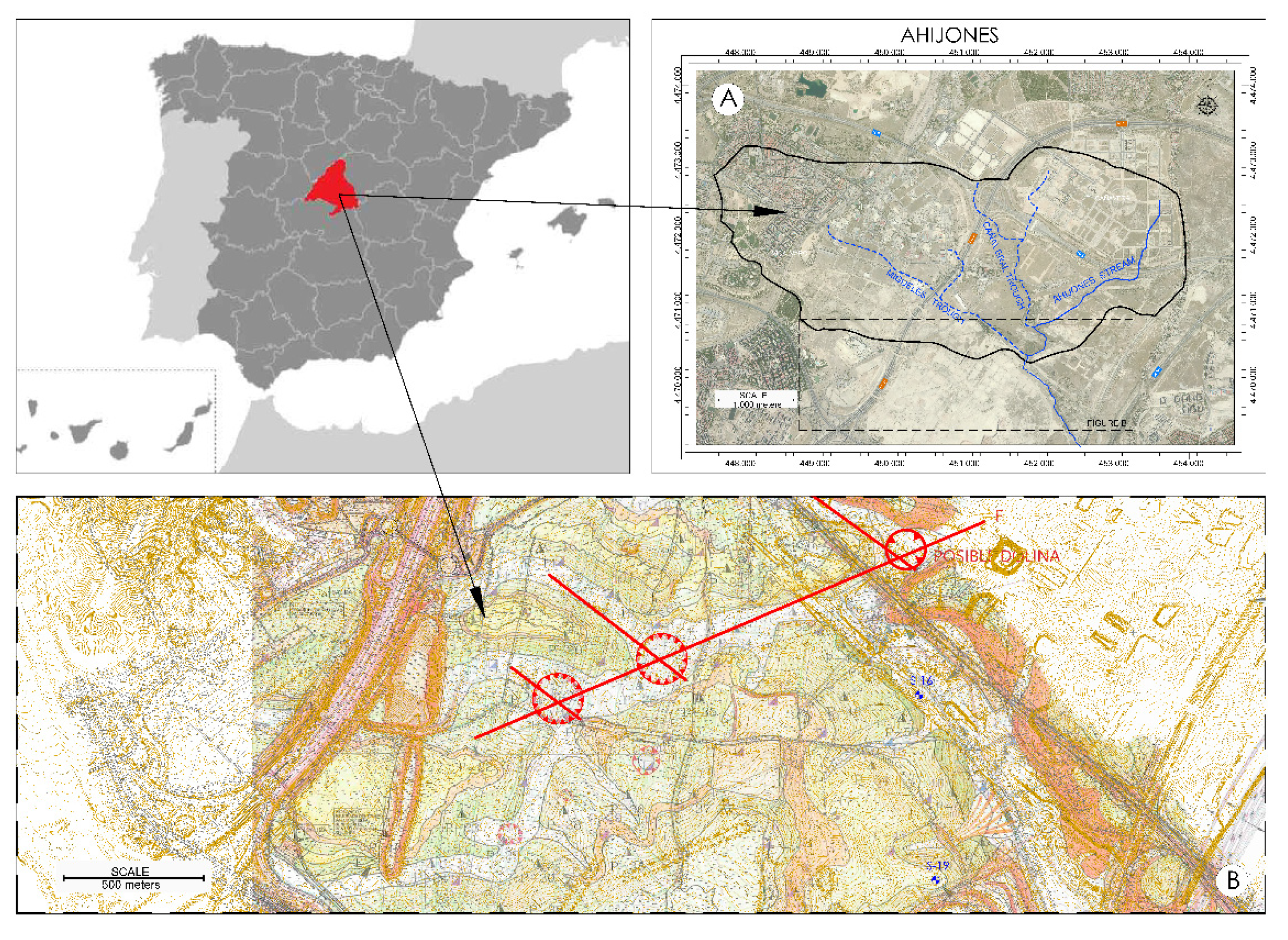
The study area is located in the southeast of Madrid, specifically in the urbanized area of “Los Ahijones”, which is located in the Vicálvaro district of Madrid (
Figure 1). This urbanized area is 550 ha in size. The influence area of the zone is made up of the old quarter of Vicálvaro, its industrial estate, and other neighborhoods, such as “El Cañaveral” (539 ha), which began construction work at the end of 2006. It is a fairly flat area, where approximately 20% is urbanized. This district also has a large area of undeveloped land: “Los Berrocales”, “Los Ahijones”, and “Los Cerros”. The urbanization comprises part of the surface area of the hydrological basin of the stream of the same name, which covers a total of almost 7 km
2. The area of this study is located at the confluence of the alluvial “Los Ahijones” stream with two natural watercourses, next to the confluence with the “Los Migueles” stream (“del Prado” stream) (
Figure 1) and occupies an area of less than one square kilometer.
The most relevant geological and geotechnical aspect in the southeast area of Madrid is the karstification processes that take place in the gypsiferous rocky substratum [
8]. In this sense, and as part of previous geological, geotechnical, and hydrogeological work [
9,
10], a small basin of 500 × 300 m was revealed on the southern edge of “Los Ahijones” housing estate, in a sector (“Estevillas” alluvial) that rests on a Miocene clayey and gypsiferous substrate, covered by Pleistocene and Holocene alluvial deposits that are interpreted as the filling of a dissolution depression currently located in a fluvial valley. Project soundings in this area have detected signs of dissolution at the contact of the gypsum layers and the overlying clays, as well as the loss of penetration resistance to considerable depths. The alluvial basin is located in a relatively lower area, which favors the concentration of surface and subsurface flow and thus dissolution, as found in the work of [
11]. The development site is a large area that is interpreted as a large underlying karstification depression, within which the alluvial basin would be located [
12]. On the other hand, it is known that in this area, SE of Madrid, there may be hypersoluble salts at depth, accompanying the gypsum (halite, for example) [
1], so the possibility of finding them has also been considered important, since, in the future, and in the event of an eventual alteration of the natural flow, consequent acceleration (or deceleration) of the karstification processes could occur. All this led us to think that this was a subsidence zone where the underlying karstification could still be more or less active.
However, mapping areas affected by subsidence is often a difficult task and can have a high degree of uncertainty. In this particular area, the uncertainty is due to the following reasons:
(1) The identification of sinkholes and subsidence zones in the clayey formations resting on clay–gypsiferous layers of the Miocene of Madrid is not obvious, since, in many cases, they have a subtle and soft geomorphic expression. Moreover, this geomorphological expression is subjugated or erased by sedimentation processes (alluvial, for example) and natural erosion, or filled with anthropic materials. Specifically, in the immediate surroundings, 500–700 m to the south, there are several sinkholes with a very soft bottom and of a similar size located on green clays (“peñuela”) resting on gypsiferous clays or gypsum (
Figure 1) [
8]. They are located at the intersection of old riverbeds or alluvial channels (which can be interpreted as the intersection of fractures). In other words, the geological situation is exactly the same as the depression we are studying here.
(2) Some depressions are complex and are related to uncertain or mixed origins (e.g., karst, fluvial, and/or lagoonal), although all have a karst origin.
(3) To quantify the current average rate of subsidence, it is necessary to know how long it has been occurring, and we do not always have data to date the most recent geological formations.
(4) There is no evidence of surface manifestations of recent subsidence: looking at the sequence of aerial photographs from 1956 to the present day, there is no evidence of the formation of sinkholes in this particular area. On the ground, there is also no evidence of significant subsidence in the fills that partially cover the alluvium, nor in the embankment of the metro line that borders it.
3. Methodology
In this type of study, it is essential to investigate as many surface and subsurface sources of information as possible to provide data on current or past subsidence activity in the study area. Prediction will depend to a large extent on an understanding of the local geology and hydrogeology. A phased sequence of investigation has been used, using, for example, geophysical prospecting prior to drilling boreholes. The methodology followed is explained and justified below:
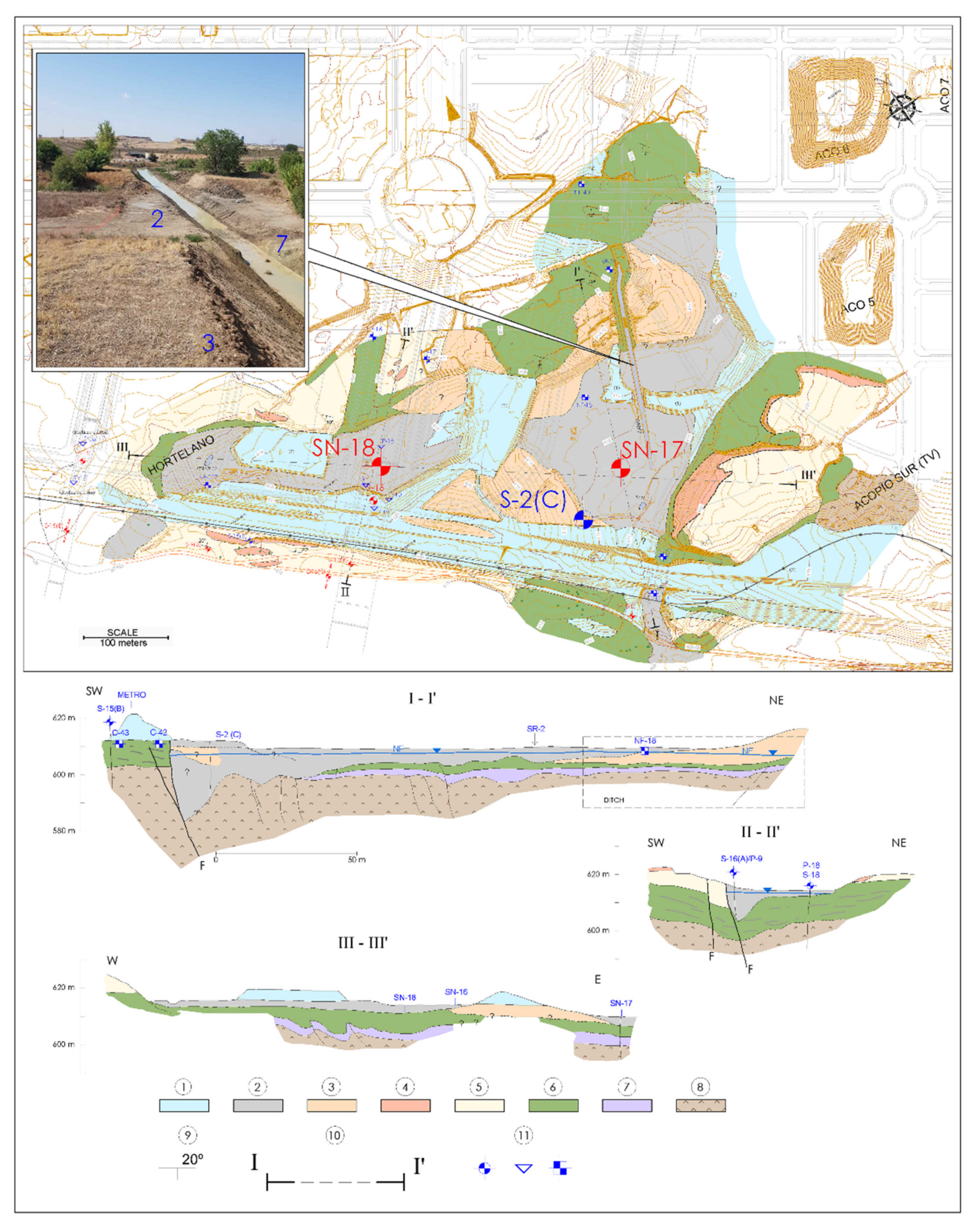
(1). Compilation and analysis of all previous geotechnical studies of the area and its surroundings. The geological map (
Figure 2), in addition to the surveys carried out in this work, also shows the situation of the surveys carried out prior to the aforementioned reports.
(2). Detailed topographic survey of the basin with equidistance of 0.25 m in order to identify closed depressions.
(3). Detailed geological mapping of the subsidence depression including slopes and surroundings of the alluvial sector studied, at a scale of 1/2000 (
Figure 2 and
Figure 3). The aim was to assess the geology under the alluvium by the extrapolation of outcrops, especially the layer of massive gypsum and its degree of karstification. As the geology beneath the alluvium could not be easily measured using the dimensioned representation system, other techniques were used to draw inferences about it. Due to the thickness of the alluvium, the trial pits did not seem to reach the substratum easily. Due also to the presence of a flint bolus in the same alluvium, which could lead to rejection, penetrometers were also rejected. Therefore, a geophysical campaign was planned to identify cavities or anomalous fills and to obtain “early detection” of subsidence.
(4). Geophysical prospecting. The geophysics strategy followed was determined by the result of the dissolution processes to be detected. According to local experience [
9], the result of these processes can be divided into three types of cases: (1) actual hollow spaces; (2) strong fillings of quaternary sediments in the form of the pockets of old hollows in the gypsum of the substratum; and (3) poorly consolidated silty clayey fillings of low density that are the residue left over from an area of an original layer of gypsiferous clays where the gypsum has been dissolved.
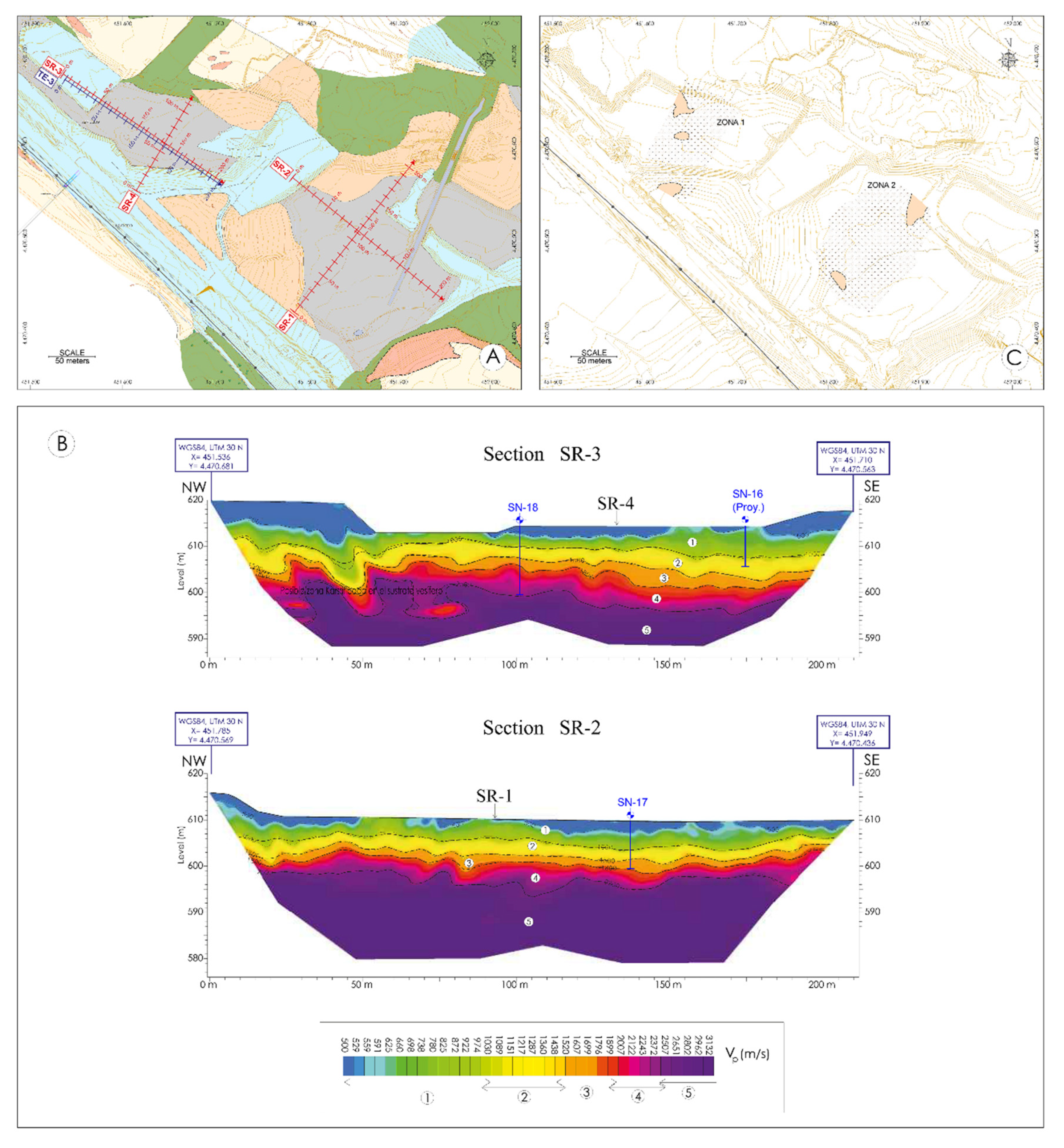
The strategy consisted of carrying out a preliminary study by means of refraction seismic and electrical tomography with four profiles along the length and width of the two sectors in which this alluvial could be subdivided in order to identify the substratum layers and Quaternary thicknesses (
Figure 4). In the case of tomography, it was also aimed at distinguishing “anomalous” areas such as possible clay rich or debris rich fills [
12]. The presence of a conductive wet clay substrate below the water table discouraged the use of ground penetrating radar (GPR) [
13,
14], which has been so useful in detecting the voids and fills of former flint workings in this urbanization.
Refraction seismic measurements were made using a 24-channel digital seismograph, model Summit II Compact (s/n 10070027), together with vertical geophones, type SM-4U, with a natural frequency of 10 Hz. The seismic deployments were 115 m, made up of 24 geophones spaced at 5 m intervals. Signal recordings were produced at seven shot points per deployment, with one shot point every four geophones. This study operated with an overlap of six geophones between adjacent deployments.
A Super Sting R8 system (s/n 0609219) with a connection box for the simultaneous control of up to 112 electrodes distributed in 8 special cables of 14 electrodes per cable was used to measure the apparent resistivity of the ground. Electrical tomography measurements were performed using a pole–dipole type focused device with the appropriate characteristics to achieve the required research depth, with the highest possible lateral and vertical resolution. These characteristics were as follows: Electrode spacing, a = 5 m. Number of depth levels measured, n = 16.
Finally, it should be noted that geophysical measurements were carried out on all profiles without any interference, obtaining good quality data.
On these last geophysical surveys, another method of higher resolution was applied, microgravimetry. A high resolution microgravimetry survey was carried out with a dense network of measurement points (with an accuracy of 5–6 μ Gales). In the area in question, microgravimetry can be considered, in principle, as a method that could provide a satisfactory explanation for the presence of the three cases of dissolution mentioned above. The morphological traces left by the dissolution processes show a relative loss of mass and consequently a reduction in gravitational attraction [
15]. The measured variations are interpreted in relation to the existence of the three possible cases cited in the subsoil at a survey depth of no more than 25 m and present a strong contrast in density with respect to the surrounding medium.
IGT used an Autograv CG-5 microgravimeter to carry out this study. To determine the absolute elevations of all the measurement points of this study and existing significant topographic projections, a Leica TCRP-103 total station with an angular accuracy of 6 s and a GPS Hiper Pro-GPS system were used.
This survey was subdivided into two sectors of half a hectare each. As has been said, the aim was not to cover the entire depression (except for the foundations of the viaduct of the most important structure,
Figure 4), but rather to determine the type and frequency of occurrence of these “karstified” areas, and the degree of progress of this karstification according to the differentiation of the cases mentioned. The map in
Figure 4 shows the location of the refraction geophysics lines, electrical tomography, and areas investigated with microgravimetry.
(5). The drilling of two research boreholes in the geophysical anomalies was detected in the two aforementioned alluvial sectors (SN-17 and SN-18) (
Figure 4). It should not be forgotten that different phenomena in the subsoil can lead to a similar response. The characteristics of the anomalies must be confirmed by intrusive methods such as probing, drilling, or trenching [
16].
These probes reached the gypsum and allowed for the recognition of sediments disturbed by karstification processes. In addition, detailed test drilling has been carried out, accompanied by X-ray diffraction analysis to identify the possible presence of hypersoluble minerals. These analyses are essential as it is very difficult to identify visually mineral species such as halite, thenardite, epsomite, etc., when they are dispersed. Water analyses were also carried out as the boreholes were included as piezometers in a wider piezometric observation network that includes the entire urbanization.
(6). Retrodeformation analysis. On the other hand, the documentation of 35 boreholes and 90 research trial pits distributed throughout the development from previous works [
9,
10] made it possible to reconstruct the geological structure of the site in great detail: synclines, fault planes, collapse zones, etc., and gave information on the mechanisms and cumulative displacement on subsidence. This has allowed for the analysis of retrodeformation through the progressive restoration of the sedimentary layers and the interpretation of subsidence episodes over time, as well as finding out the somewhat uncertain origin of the “Los Ahijones” depression.
(7). Direct inspection of road excavation, earthworks, and trenches. The numerous and extensive excavation works in most of the development have allowed for direct inspections that have provided additional objective information on the characteristics and chronology of the deformation history, incorporating a temporal dimension that is generally lacking in other research methods. Paleokarst and other ancient karst subsidence zones, for example, have been recognized.
(8). Determination of the age of the surface formations according to the bibliography and eventual geochronological dating in some tuffs surrounding the depression, in order to quantify subsidence rates according to quaternary thicknesses and measured deformations.
(9). Hydrogeological investigations. Understanding the hydrogeology (including hydrogeochemistry) of a study area is a crucial aspect of subsidence hazard analysis. Groundwater flow is the geological agent responsible for karstification in evaporite rocks and is often one of the most important conditioning and triggering factors of the generation of sinkholes. We also carried out the hydrogeological study of the area, including flow modelling [
10]. The results of this study will be used for the purposes of this work.
(10). Prospecting to detect the possible presence of hypersoluble salts. In the Miocene subsoil of southern Madrid, the typical facies of evaporites can be arranged from roof to wall as follows: gypsum (CaSO
4·2H
2O), unaltered thenardite (Na
2SO
4·7H
2O)/glauberite Na
2Ca (SO
4)
2, halite (NaCl), glauberite, and halite, with thenardite and halites being very soluble. Sometimes they are accompanied by other very soluble minerals, such as mirabilite (Cienpozuelita) Na
2SO
4·10H
2O, Polyhalite K
2Ca
2Mg (SO
4)
4·2H
2O and epsomite (Vaciamadrid salt) Mg (SO
4·7H
2O. The presence of these salts may play an important role in the development of dissolution induced subsidence in these doline zones, or may pose the risk of the rapid acceleration of karstification if water conditions are altered, such as in tunnels [
16].
In order to detect the presence or absence of hypersoluble minerals, the following tests were carried out:
Two research boreholes (SN-17 and SN-18) were drilled to a depth of approximately 595–597 m. Research was carried out to detect special salts up to this level, although it is assumed that the results are also valid for somewhat greater depths. However, as it is sometimes difficult to recognize such salts visually if they are present in small quantities, they were identified indirectly by water analysis and directly by mineralogical analysis.
Chemical analysis of groundwater from the gypsum beneath the alluvium, which was obtained from piezometers SN-17 and SN-18.
Analysis of water from the dissolution of salts present in cores (chosen from the depth where the most gypsum appears) from boreholes SN-17 and SN-18 (by immersing the cores in distilled water for 60 h).
Semiquantitative analysis of samples by X-ray diffraction, and study of thin films for petrographic microscopy.
4. Results
4.1. A Small Closed Topographic Depression in the Alluvial Trough
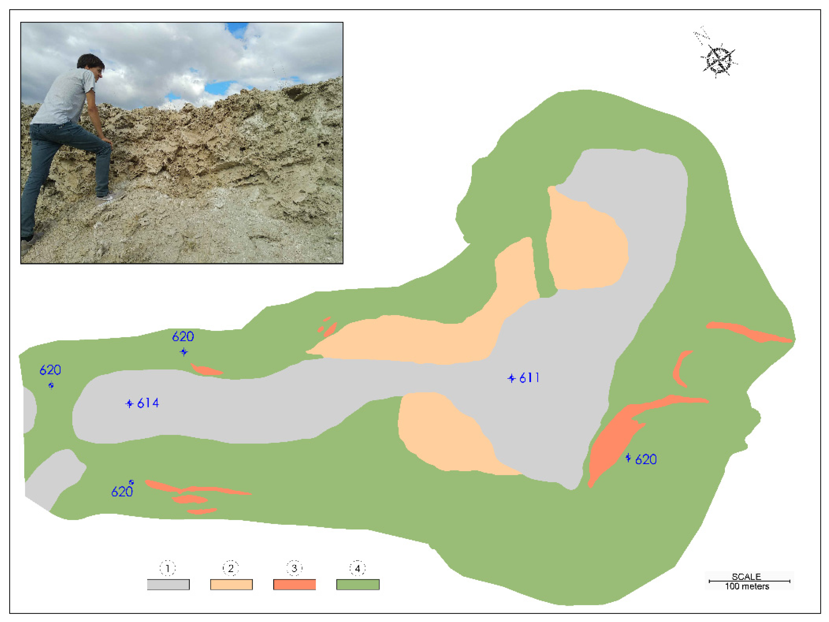
As a result of a detailed topographic survey, a rounded topographic depression of about 80 m in diameter and no more than 0.5 m of negative curves appeared in the southeast area of the basin. It can be interpreted as a very soft doline that tends to become waterlogged when it rains.
4.2. Stratigraphy of the Subsidence Alluvial Basin
The stratigraphy described in detail here refers to the small subsidence basin under study, although the stratigraphy of the Miocene substratum of the rest of “Los Ahijones” depression is also reported. In the geological map in
Figure 2, we can differentiate the following geological units, ordered from oldest to most modern:
Miocene geological formations:
More or less massive lower Miocene–Middle Miocene lower unit. It has been cut into several boreholes in previous projects and in those carried out for this study near the bottom of the alluvial.
Clays with intercalated layers of gypsum or gypsum with intercalated layers of clay. They also do not outcrop, but have been identified under the alluvial in the previous boreholes and in the two research boreholes mentioned above. In the refraction seismic profiles, they are identified with velocities of between 1500 and 2000 m/s, and powers between 0 and 7 m.
As an integral part of this unit, dark green clays appear in areas that are poorly differentiated from the rest and are interpreted as the residue of the karstification of the gypsum rich layers.
Clay and green silt laminated with intercalated layers of fine to medium grained, very micaceous sands (“Peñuela” in the area). According to soundings, the thickness varies between 5 and almost 10 m.
Sandstones, dolomites, limestones, flint levels, and clay intercalations. This is the most permeable “layer” within the intermediate unit and here it has a small thickness, no more than 3 m; under the alluvial it hardly appears at all.
Sepiolite clays. They outcrop outside the area, to the east. They do not occur under the alluvial.
Quaternary surface formations
We distinguish, from older to more modern:
Initially, it was thought that the T4 terraces were imbricated with respect to the Holocene alluvial deposits, as is partially the case in other alluvial paleochannels of “Los Ahijones”, according to [
11]. The results of these surveys, the cuts of the drainage trench, and the research drillings do not seem to confirm this imbrication in all the edges of the basin: the T4 terraces are hanging in a sector of the northern edge (in the ditch zone, as already mentioned), but in the fault zone and axial zone of the syncline there is possibly punctual imbrication. The Holocene has an overall thickness of less than 4 m and consists of dark brown clayey muds and soils with organic matter in the upper part, and feldspar and quartz sands and some gravel in the rest. However, in the southern edge fault zone, there are average thicknesses of more than 10 m that are considered Holocene.
4.3. Structure of the Great Ahijones Depression and the Subsidence Trough
Using data from the numerous boreholes and test pits available, isoline maps of the absolute elevation and depth of the contacts of the substratum layers defined above have been generated. With these maps, it has been possible to make a geological cross section representative of the urbanization. We can see in this geological section that the layers are subhorizontal, although they adapt to a dissolution depression that affects the gypsum, giving rise to a syncline and a fault. The great depression of “Los Ahijones”, some 500 ha in size, forms a depocenter, where, due to the underlying karstification processes concentrated in a NW–SE fault coinciding with the Migueles stream, an elongated and narrow syncline has been created in the clayey cover, which has had an important influence on underground drainage [
10].
This fault is in line with the bed of the “Los Migueles” stream and, although it was not known, it must be included in the group of faults that affect the substratum in this part of the Tagus basin and are also reflected in the cover. This fault is of the direct or normal type, measuring a drop of about 5–10 m, with the sunken block being the one to the north. This local resubmergence has preserved the entire stratigraphic column from erosion, including the Quaternary.
Referring to the alluvial basin, and as can be seen in the map and geological sections of
Figure 2, the dips in the outcrops of the Miocene substratum of the alluvial environment are all directed towards the center of the depression with values between 8° and 20°, the latter near the fault zone of the southern edge. As mentioned above, the Pleistocene T4 terrace deposits and tuffs also dip up to 15° towards the center of the depression. The geological cross sections in
Figure 2 show how, near the fault zone, the Miocene subsidence has been greater, forming the bottom of a syncline and the greatest thickness of the recent Quaternary.
4.4. Characteristics of Paleokarst
Within the large “Los Ahijones” depression, sedimentation during the Quaternary has been controlled by subsidence, caused by more or less localized karst processes. A network of Pleistocene paleochannels is highlighted, adjusted to fractures where sedimentation is strongly controlled by the underlying karstic subsidence, causing locally significant sedimentation rates, and even lacustrine deposits. These paleochannels, around which the geoarchaeological sites are located, are arranged parallel to the present day channels of the depression. In the present day valley floor channels, it is common to see the presence of Pleistocene deposits stratigraphically below the Holocene deposits [
11]. There are also two subsidence sinkholes filled with Pleistocene sediments no more than 4 m thick and measuring 100 × 200 m [
11]. In the land clearance of the nearby M45 highway, synclines of up to 300 m can be recognized, with residual dark green clays at their base, which are the result of the dissolution of the gypsum. These dark green clays can also be found around the alluvial basin.
4.5. Existence of Karstification in the Gypsums
It has already been said that boreholes around the fault zone of “Virgen de la Torre” hermitage corresponding to the previous geotechnical projects showed numerous symptoms of karstification in the gypsum, such as the existence of residual dark green clays from layers where the gypsum has been dissolved, intercalated, or mixed, small hollows, or areas where the resistance to penetration has been very low.
The different levels that we have differentiated in the seismic sections and the Vp values that characterize them are the following: Anthropic fills (Vp < 500 m/s), Alluvial (500 m/s < Vp < 1000 m/s), clays (“Peñuela”) without casts (1000 m/s < Vp < 1500 m/s), clays with casts (1500 m/s < Vp < 1800 m/s), casts (1800 m/s < Vp). Within the gypsums, we have differentiated between weathered and healthy ones, placing the limit between the two at around Vp = 2500 m/s.
One of the refraction seismic and tomography profiles seemed to indicate possible anomalous karstified zones on top of the massive gypsum as possible clay rich fillings (
Figure 4). Due to this uncertainty, microgravimetry tests were completed.
The microgravimetry survey identified five small amplitude gravity minima (
Figure 4), two of which were anthropic fills. The other three should be associated with the three possible cases mentioned above, or a combination of these. In an anomaly, a borehole (SN-18) was drilled, which allowed us to recognize that it was a soft clayey gypsiferous zone from the Miocene up to 16 m. This is probably the same as with the other anomaly B1, where there is little alluvium thickness. Other anomaly data from another borehole (S-2 in
Figure 2) were also available, which confirmed the thickening of the alluvium on this side close to the 14 m fault zone.
4.6. Hydrogeology
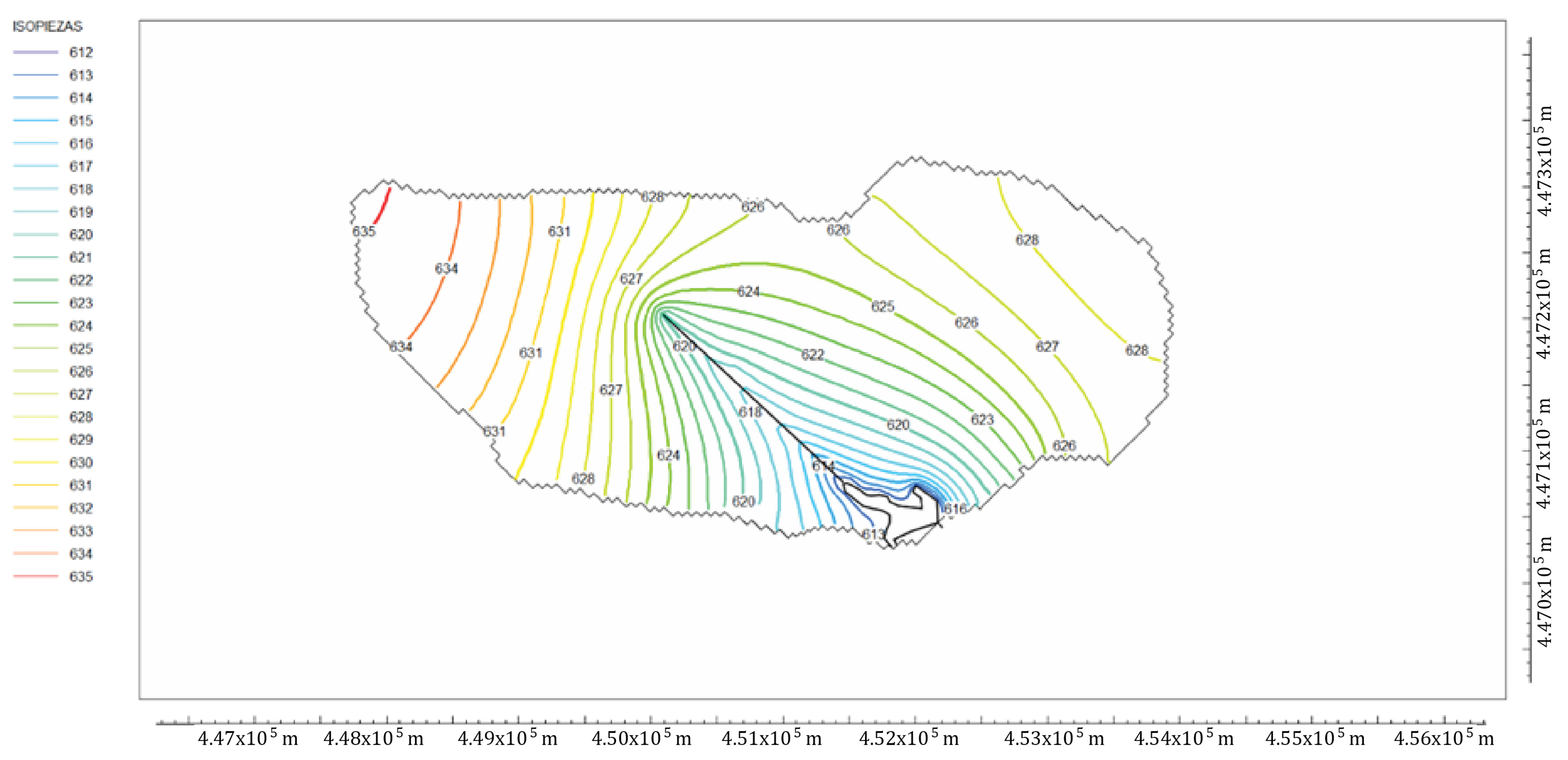
The piezometric control network shows that the water table is well adjusted to the topography, with a fairly epidermal flow associated with the clayey formations of the Miocene. The role played by the elongated and faulted syncline of a NW–SE direction and higher permeability, which conditions and redirects the regional flow to a great extent, is highlighted (
Figure 5). The hydrogeochemical conceptual model is well explained by the geology of the site: the predominance of calcium-magnesium bicarbonate facies in the Miocene clayey layers, and calcium sulphate facies when there is the influence of the gypsum if they are close, either at depth or in the areas located to the east where they outcrop.
With regard to the application of MODFLOW, two simulations were carried out: one in the natural regime prior to the works, where the isopiestic line map was used based on the level of the wells and test pits carried out in the 2006 geotechnical project, and another in 2019, in which a piezometric network of numerous boreholes drilled specifically for this purpose was available. There was also a large amount of permeability data (Lefranc tests) and a very precise geometry of the different hydrostratigraphic units, so that transmissivity estimates were fairly accurate. Natural isotopes showed that the origin of the recharge was rainfall and was preliminarily quantified by means of hydraulic balances (9, 10). This was used to simulate various current situations, such as the effect of a long network of drainage ditches on the groundwater table, or the decrease in recharge due to the partial urbanization of the area from 2019 onwards.
Modelling of the aquifer [
10] has revealed that natural recharge in the clay aquiclude is minuscule and does not reach 1% of the useful water of the hydraulic balance (0.16 mm/year). It has also revealed the general hydrogeological behavior of the lower gypsum layer. This layer has a general permeability similar to that of the clay aquiclude (despite possible local karstification) and is recharged in an induced manner through this layer. It discharges into the lower part of the alluvial part of “Los Ahijones” stream via an upward flow and longer streamlines, which explains the high sulphate content of the groundwater in this area. This flow has been quantified by MODFLOW simulation to be no more than 2 L/s [
10].
4.7. Presence of Water-Soluble Salts?
In the visual inspection of the evaporite samples obtained from the two boreholes mentioned above, only gypsum was recognized, and no hypersoluble salts were clearly identified. On the other hand, and according to the chemical analysis of the piezometer samples, the groundwater is dominated by calcium in the gypsum, but the ionic content of chlorides and sodium is small, so the water has a sulphate facies, typical of gypsum, but does not present significant amounts of chlorides or Na, which would have indicated the presence of halite, thenardite, or glauberite, for example.
The water analyses from the dissolution of the salts present in cores (chosen from the depth where the most gypsum appears) from each of boreholes SN-17 and SN-18 have a certain proportionality with the groundwater analyses, but give lower values, as expected. Nor are there significant amounts of chlorides and sodium, indicative of the significant presence of hypersoluble salts.
In addition, semiquantitative analyses of samples by X-ray diffraction and thin sheet petrographic microscopy have not detected significant contents of highly soluble mineral species beneath the quaternary alluvium. There is no halite, polyhalite, or epsomite, which could be suspected to be because of the high Mg content in the water; for example, it is seen that the high content of this ion is due to the magnesian clays in the “peñuelas”.
6. Conclusions
During the last decades, sinkhole hazards and associated risks have increased in many inhabited areas (e.g., [
14,
18]). There is an emerging trend in many karst regions to incorporate scientific knowledge of sinkholes into hazard prevention in land use planning (e.g., [
1,
32]). However, this knowledge transfer has not yet been sufficiently extended to planners and managers, which would avoid significant economic losses [
17] and lead toward sustainability in the urban world.
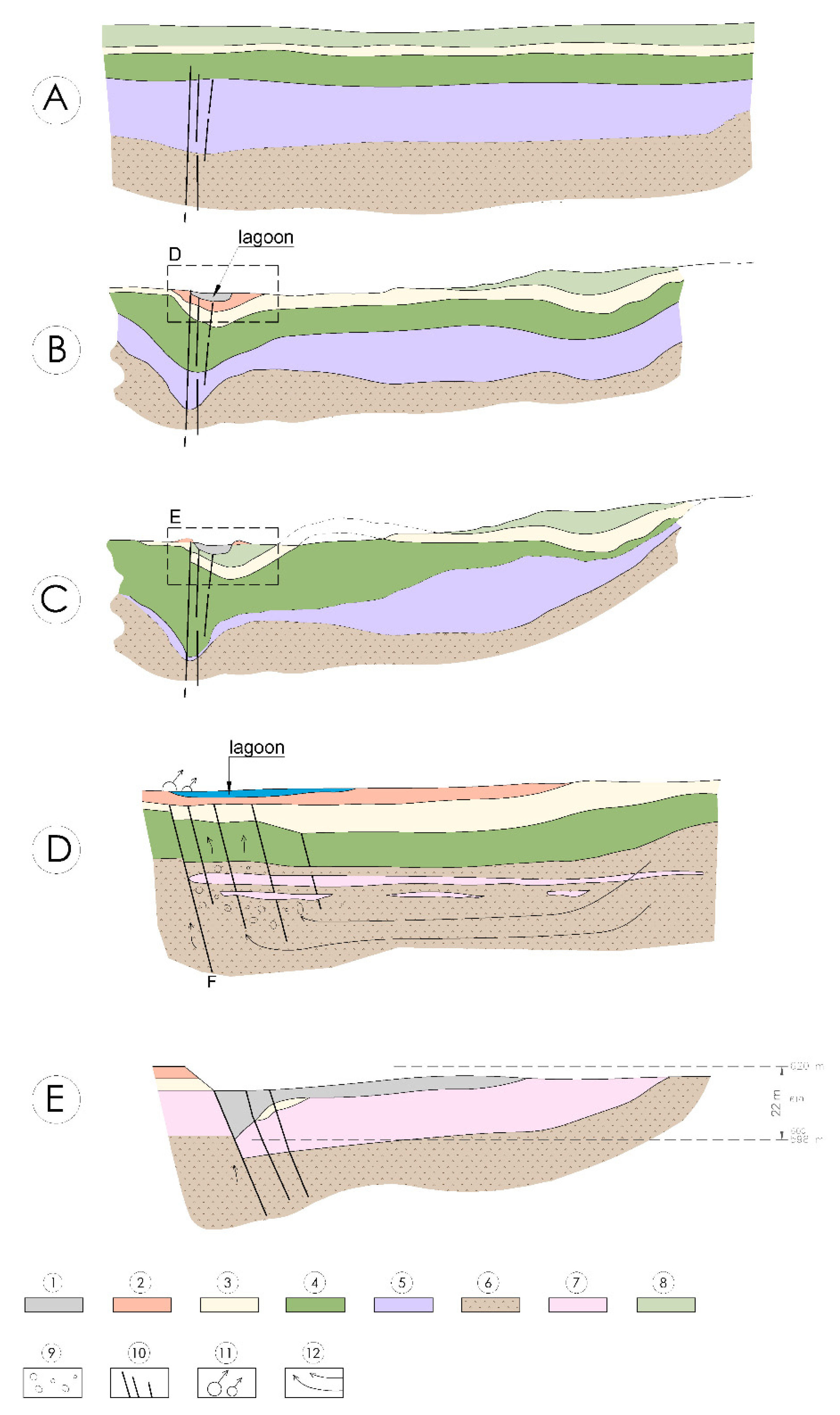
Thanks to the application of different combined methods, it has been possible to determine that the small subsidence basin studied corresponds to the most active sector of a large depression formed by underlying karstification during the Quaternary. This clay-covered doline has been produced by slow flexural subsidence due to the removal of the bedrock and cover by dissolution of the interstratified layers of gypsum rich clays. It conforms to a fault and axis of an atectonic syncline that has concentrated the dissolving subsurface flow, accentuating the underlying karstification and topographic subsidence until the formation of a microlake basin during the Pleistocene. The karstification progressively exaggerates the syncline, and in a sector of the fault and bottom of the syncline there is collapse. As we can see, the dissolution is the cause of the syncline, and the syncline is the cause of the concentration of the flow: these have a cause and effect relationship with each other over time. The result is that the basin or doline filled with the alluvial formations of the Holocene age, mainly, in which there is groundwater discharge and the mouth of a stream (“Los Ahijones”), together with two natural watercourses.
The current average decrease could be evaluated at about 0.4 mm/year and concerns the alluvial zone, and the maximum is 1.4 mm/year in the fault zone. The possible karstified areas, karstified residues, soft patches, and anomalous alluvial fills in former hollows only represent between 5% and 12% of the hidden area beneath the alluvium. They have dimensions of less than 20 × 20 m and depths of less than 20 m. In the future, no acceleration in dissolution is expected because the flow will be substantially reduced by the draining action of a drainage ditch in the process of urbanization, and because there are no significant quantities of highly soluble mineral species.
The urbanization works, which are in full progress, are undertaking complementary measures aimed at the stability of the road by removing and cleaning up the alluvial deposits studied.
In those areas where road infrastructure is to be developed on the alluvial areas, during the execution of the urbanization works, constructive measures are being considered consisting of the complete removal of the alluvial material (whose depths detected in the road have not been greater than 5 m), to subsequently execute a gradual embankment with reinforced geotextile protection. This construction procedure has allowed us to work in a wet area and guarantees the good mechanical behavior of the upper embankment.
In the case of the only area where a road structure must be implemented, the foundation avoids karst fillings and will be piloted, thus guaranteeing stability and functionality. To this end, geotechnical soundings will be taken at the site where the foundation piles are to be driven to guarantee the exact depth of the stable support stratum at the tip of the pile.
The area most affected by the aforementioned subsidence refers to the area designated by the territorial planning as an urban park, where there are no relevant infrastructures that need to be treated with special construction procedures.


