
Definition of an Operative Methodology for the Management of Rockfalls along with the Road Network


Abstract
:1. Introduction
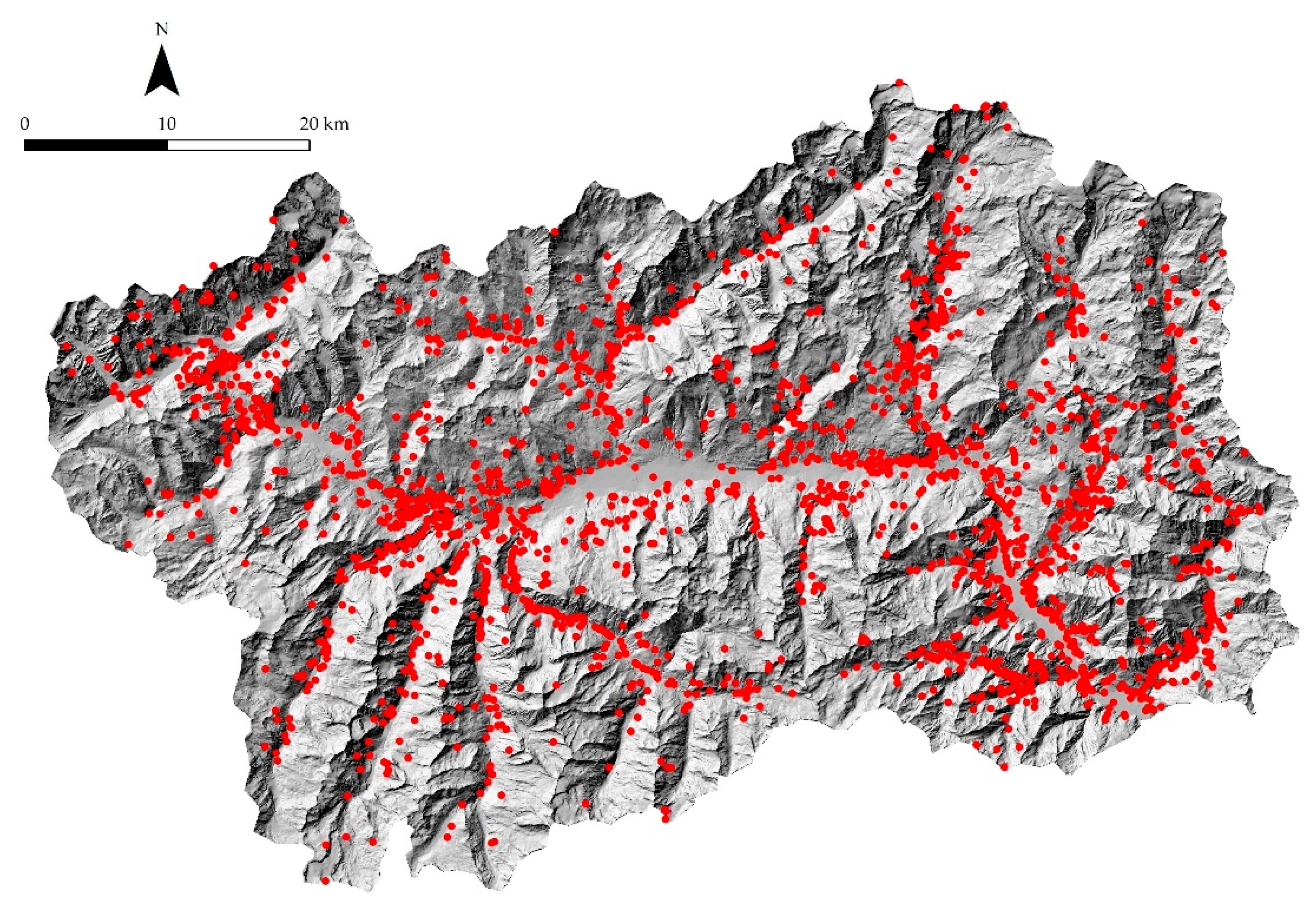
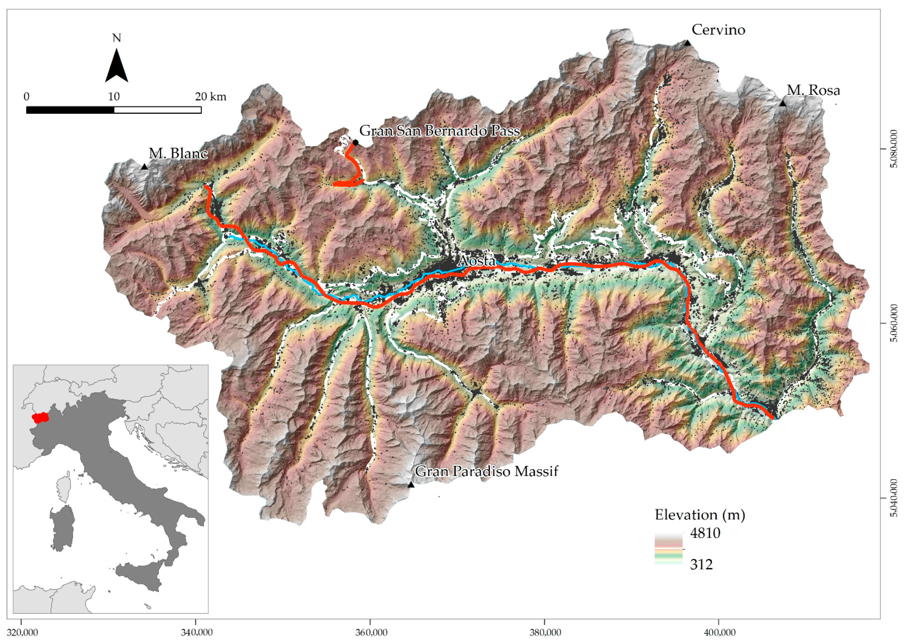
2. Study Area and Available Landslide Dataset
3. Methods
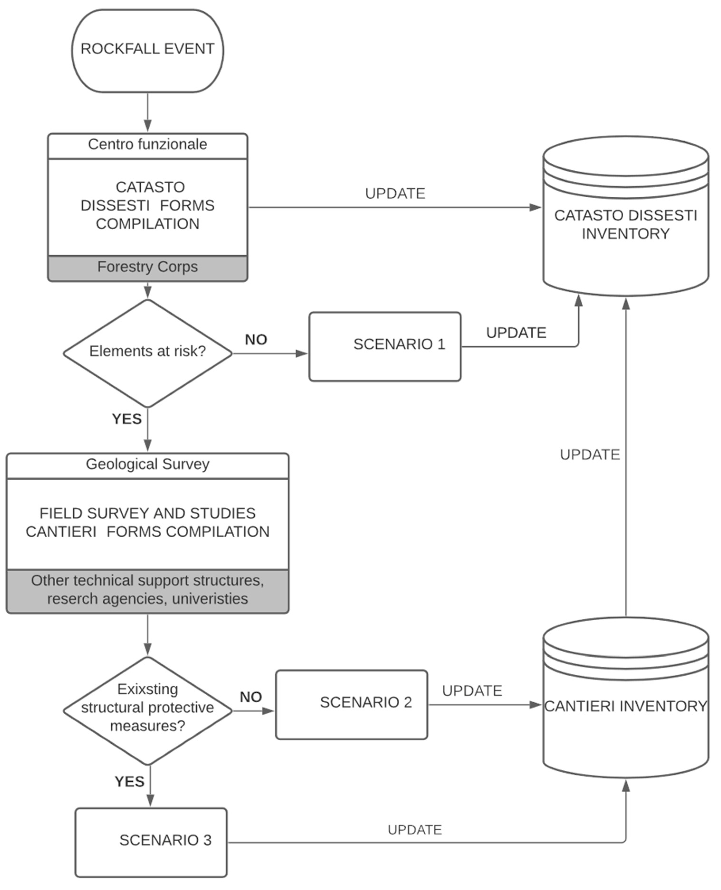
3.1. Existing Regional Scale Procedure
3.2. New Local Scale Procedure
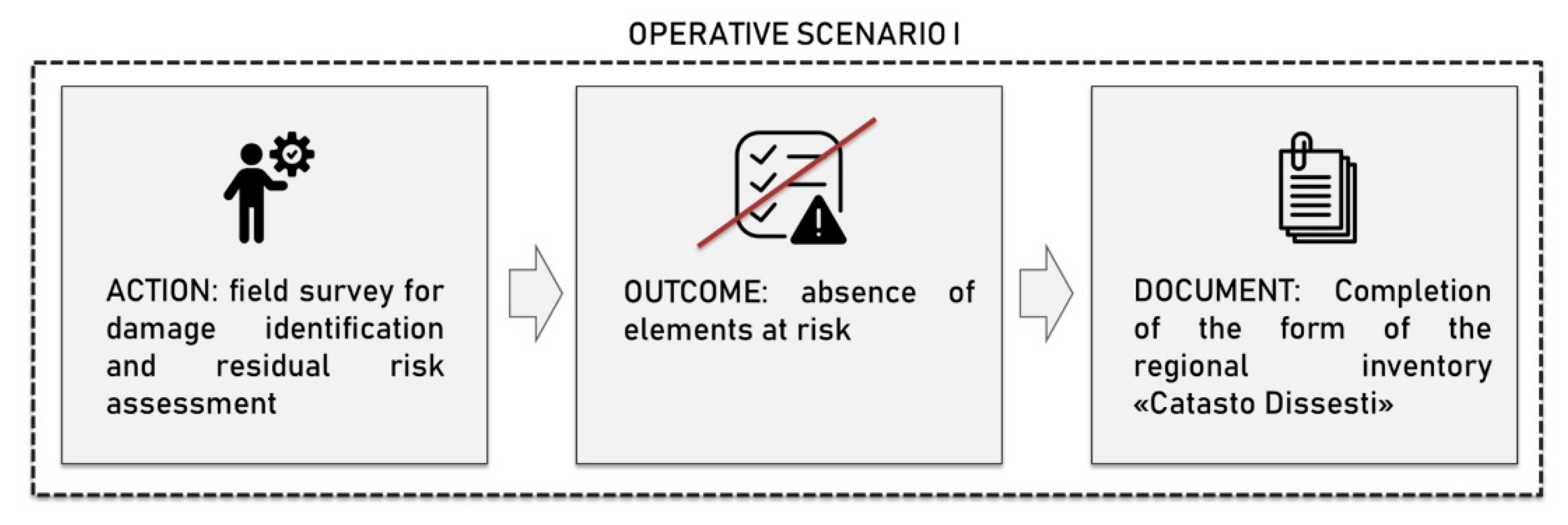
- Scenario I—the rockfall event occurs in areas where there are no previous technical studies and/or structural countermeasures and there are no elements at risk;
- Scenario II—the rockfall event occurs in areas where there are no previous technical studies and/or structural countermeasures, and it can potentially pose a risk to structures, infrastructure and human safety;
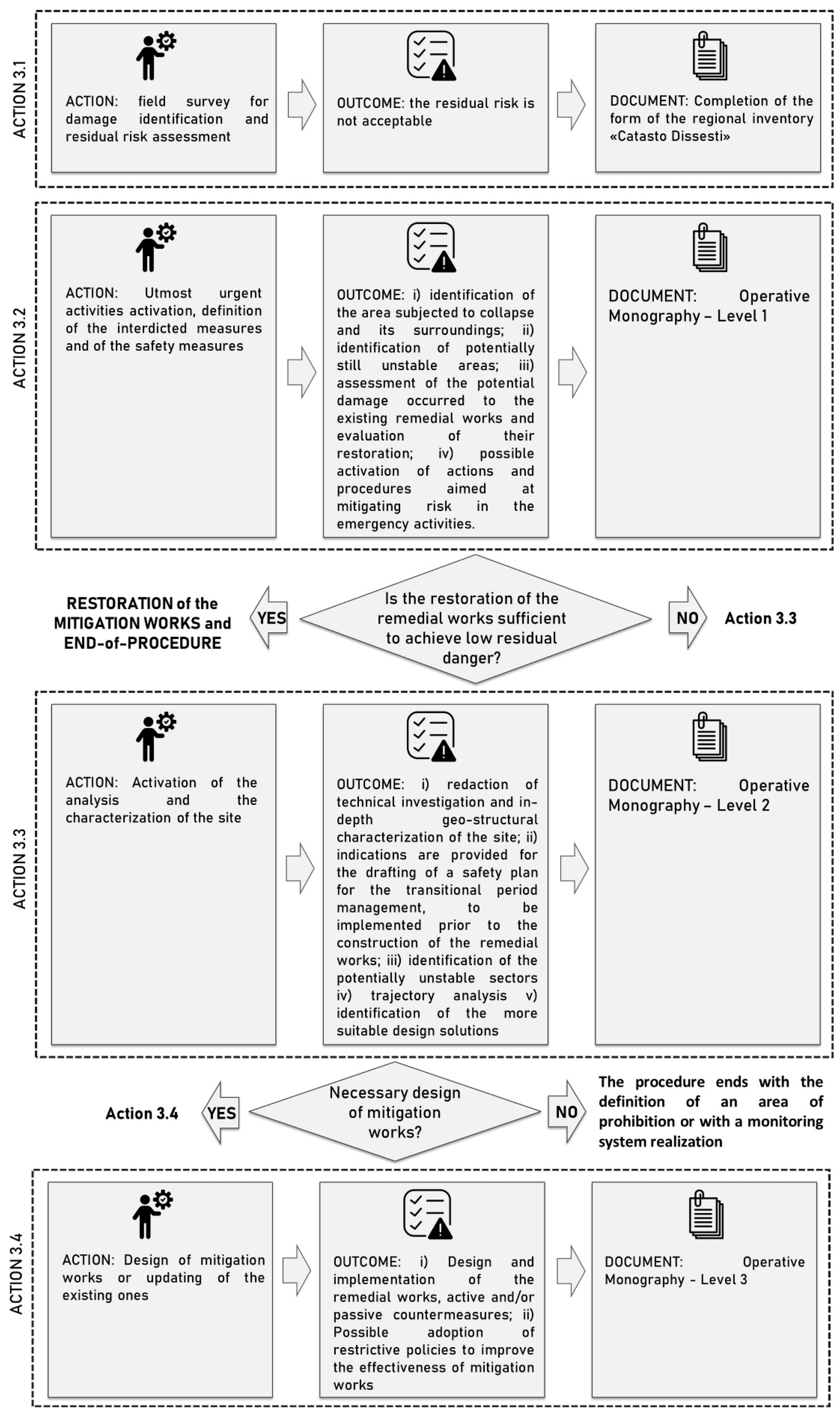
- Scenario III—the rockfall event occurs in areas where there are previous technical studies and/or structural countermeasures, and it can potentially pose a risk to structures, infrastructure and human safety.
- Rockfall event occurrence and establishment of the (eventual) emergency condition;
- Implementation of a plan for the proper management of the transitional phase;
- Design and construction of active and/or passive remedial works for risk reduction and mitigation.
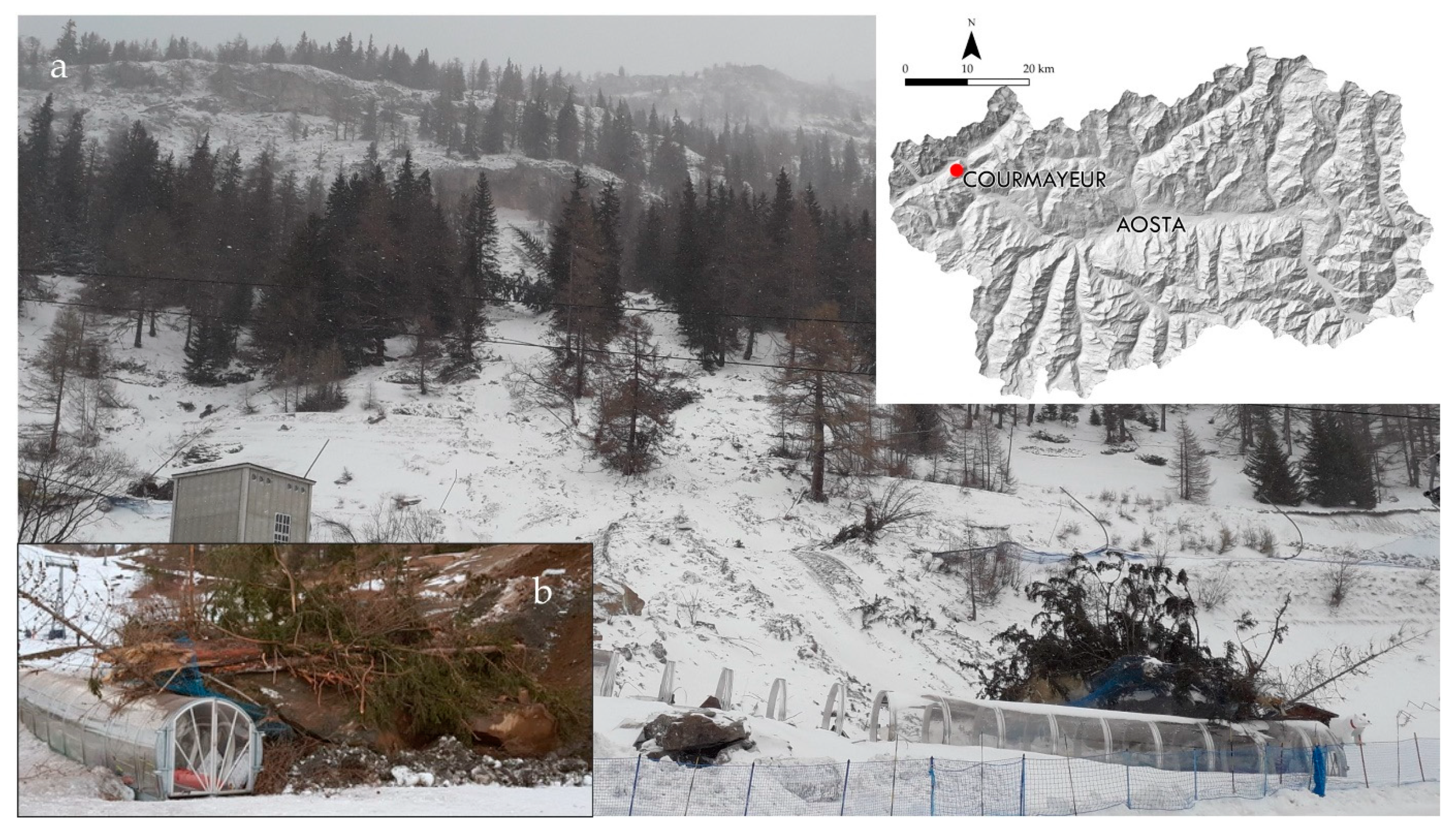
3.2.1. Scenario I
3.2.2. Scenario II
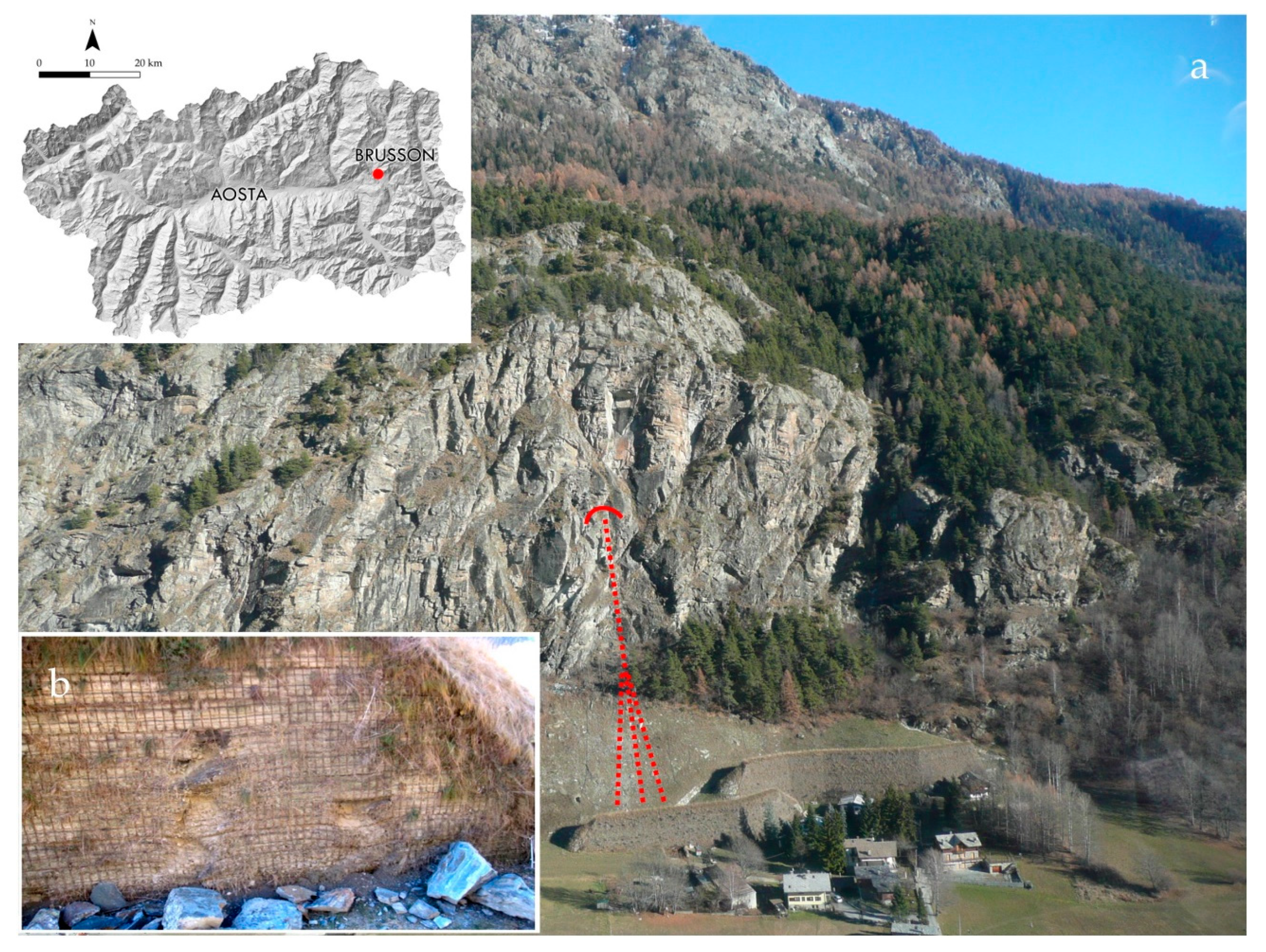
3.2.3. Scenario III
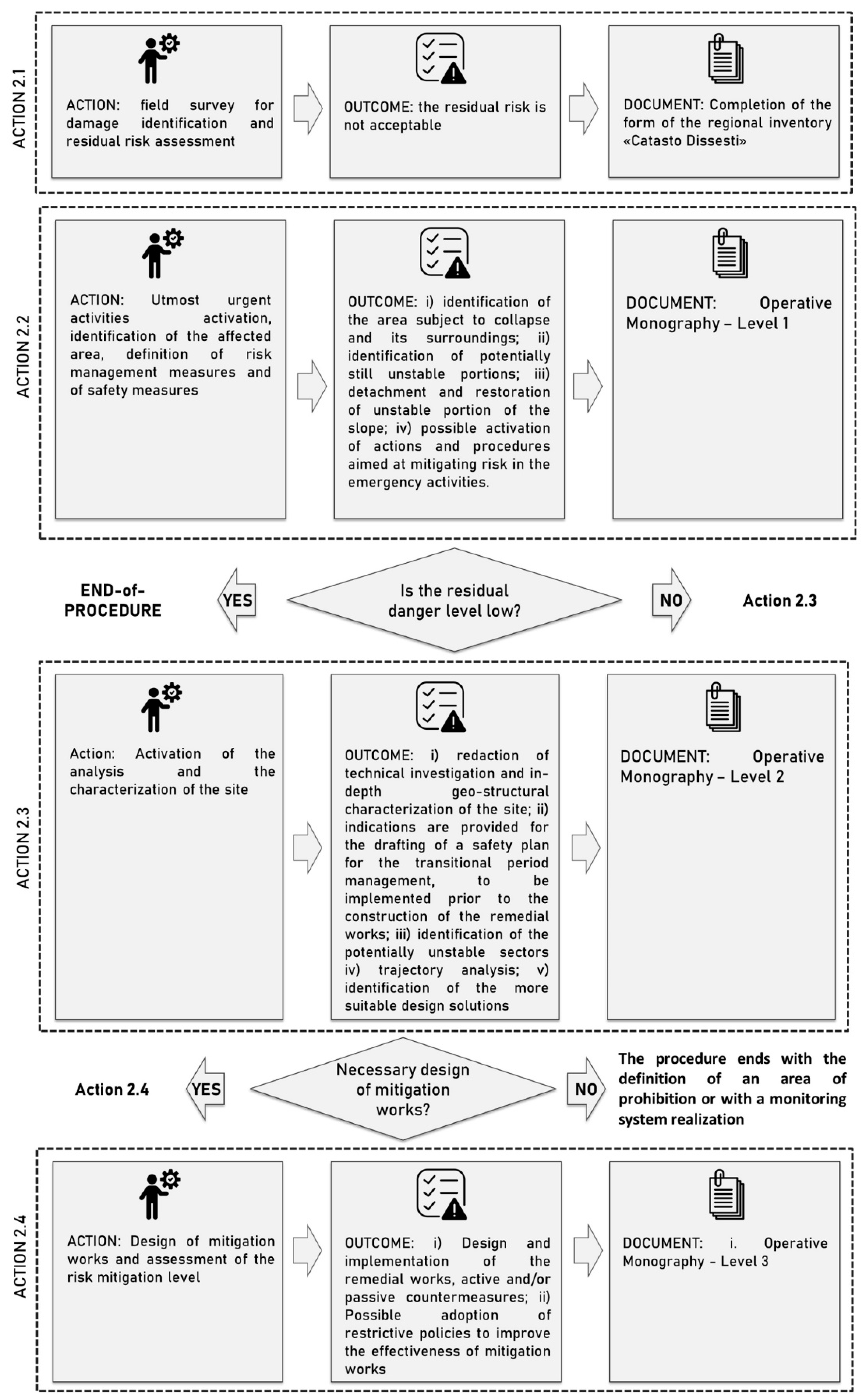
3.3. Operative Monography Customization
- Level 1: this is the entry-level of OM that includes basic knowledge about the phenomena derived from field survey observations;
- Level 2: this second level of OM contains an in-depth analysis of geological, geomorphological, and geotechnical slope characterization, dynamic effects of rockfalls and others, for which technical studies are planned;
- Level 3: this final level is dedicated to technical specifications for remedial works design.
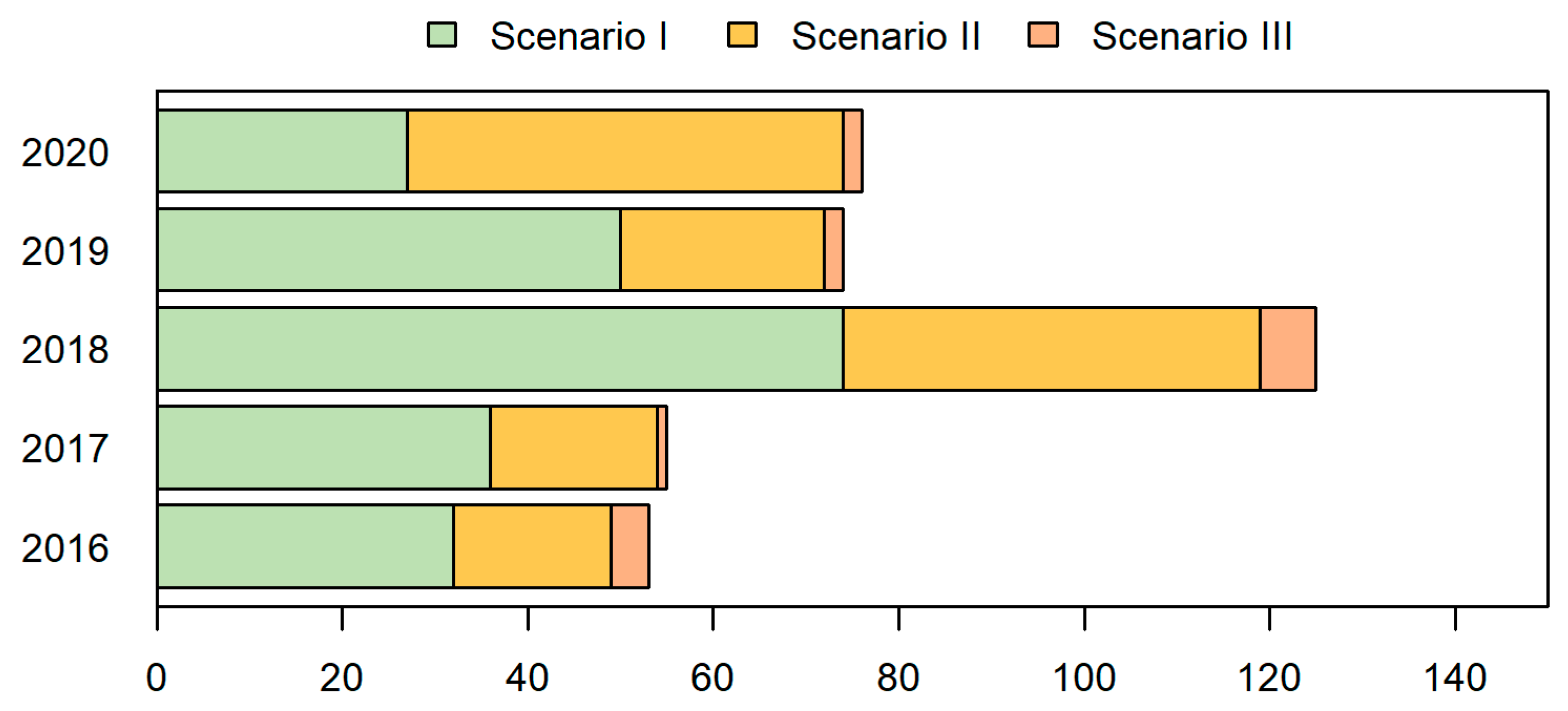
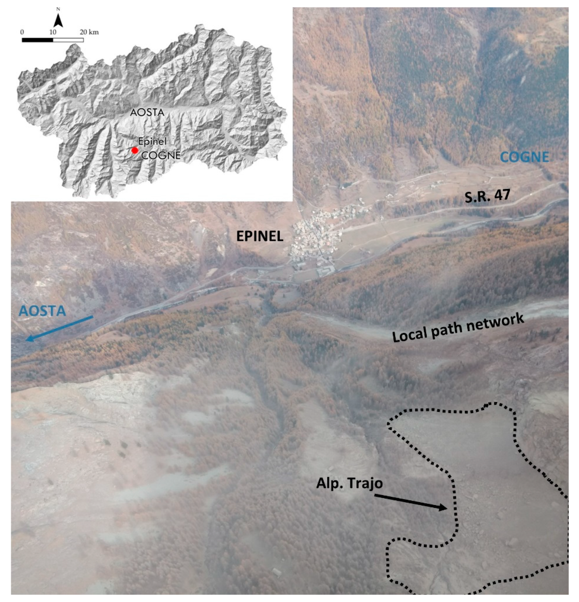
4. Results
5. Discussion
6. Conclusions
Author Contributions
Funding
Institutional Review Board Statement
Informed Consent Statement
Data Availability Statement
Conflicts of Interest
References
- Budetta, P. Assessment of rockfall risk along roads. Nat. Hazards Earth Syst. Sci. 2004, 4, 71–81. [Google Scholar] [CrossRef] [Green Version]
- Guzzetti, F. Landslide fatalities and the evaluation of landslide risk in Italy. Eng. Geol. 2000, 58, 89–107. [Google Scholar] [CrossRef]
- Hungr, O.; Evans, S.G.; Hazzard, J. Magnitude and frequency of rock falls and rock slides along the main transportation corridors of southwestern British Columbia. Can. Geotech. J. 1999, 36, 224–238. [Google Scholar] [CrossRef]
- Spizzichino, D.; Margottini, C.; Trigila, A.; Iadanza, C. Landslide impacts in Europe: Weaknesses and strengths of databases available at European and national scale. In Landslide Science and Practice; Springer: Berlin/Heidelberg, Germany, 2013; pp. 73–80. [Google Scholar]
- Carlà, T.; Nolesini, T.; Solari, L.; Rivolta, C.; Dei Cas, L.; Casagli, N. Rockfall forecasting and risk management along a major transportation corridor in the Alps through ground-based radar interferometry. Landslides 2019, 16, 1425–1435. [Google Scholar] [CrossRef] [Green Version]
- Crosta, G.B.; Agliardi, F. A methodology for physically based rockfall hazard assessment. Nat. Hazards Earth Syst. Sci. 2003, 3, 407–422. [Google Scholar] [CrossRef]
- Guzzetti, F.; Reichenbach, P.; Ghigi, S. Rockfall hazard and risk assessment along a transportation corridor in the Nera valley, central Italy. Environ. Manag. 2004, 34, 191–208. [Google Scholar] [CrossRef] [PubMed]
- Lato, M.; Hutchinson, J.; Diederichs, M.; Ball, D.; Harrap, R. Engineering monitoring of rockfall hazards along transportation corridors: Using mobile terrestrial LiDAR. Nat. Hazards Earth Syst. Sci. 2009, 9, 935–946. [Google Scholar] [CrossRef]
- Williams, J.G.; Rosser, N.J.; Hardy, R.J.; Brain, M.J. The importance of monitoring interval for rockfall magnitude-frequency estimation. J. Geophys. Res. Earth Surf. 2019, 124, 2841–2853. [Google Scholar] [CrossRef] [Green Version]
- Bunce, C.M.; Cruden, D.M.; Morgenstern, N.R. Assessment of the hazard from rock fall on a highway. Can. Geotech. J. 1997, 34, 344–356. [Google Scholar] [CrossRef]
- Macciotta, R.; Martin, C.D.; Morgenstern, N.R.; Cruden, D.M. Quantitative risk assessment of slope hazards along a section of railway in the Canadian Cordillera—A methodology considering the uncertainty in the results. Landslides 2016, 13, 115–127. [Google Scholar] [CrossRef]
- Michoud, C.; Derron, M.H.; Horton, P.; Jaboyedoff, M.; Baillifard, F.J.; Loye, A.; Nicolet, P.; Pedrazzini, A.; Queyrel, A. Rockfall hazard and risk assessments along roads at a regional scale: Example in Swiss Alps. Nat. Hazards Earth Syst. Sci. 2012, 12, 615–629. [Google Scholar] [CrossRef] [Green Version]
- Raetzo, H.; Lateltin, O.; Bollinger, D.; Tripet, J. Hazard assessment in Switzerland—Codes of Practice for mass movements. Bull. Eng. Geol. Environ. 2002, 61, 263–268. [Google Scholar]
- ISPRA Ambiente IFFI Catalogue. Available online: http://www.isprambiente.gov.it/it/progetti/suolo-e-territorio-1/iffi-inventario-dei-fenomeni-franosi-in-italia (accessed on 3 April 2020).
- Osservatorio-Turistico Osservatorio Turistico VdA. Available online: https://www.osservatorioturisticovda.it/ (accessed on 10 November 2020).
- Trigila, A.; Iadanza, C.; Spizzichino, D. IFFI Project (Italian landslide inventory) and risk assessment. In Proceedings of the First World Landslide Forum, Tokyo, Japan, 18–21 November 2008; pp. 18–21. [Google Scholar]
- Amatruda, G.; Bonnard, C.H.; Castelli, M.; Forlati, F.; Giacomelli, L.; Morelli, M.; Paro, L.; Piana, F.; Pirulli, M.; Polino, R.; et al. A key approach: The IMIRILAND project method. In Identification and Mitigation of Large Landslide Risks in Europe; CRC Press: Boca Raton, FL, USA, 2004; pp. 31–62. [Google Scholar]
- Castelli, M.; Scavia, C. A multidisciplinary methodology for hazard and risk assessment of rock avalanches. Rock Mech. Rock Eng. 2008, 41, 3–36. [Google Scholar] [CrossRef]
- Mignelli, C.; Lo Russo, S.; Peila, D. Rockfall risk Management assessment: The RO. MA. approach. Nat. Hazards 2012, 62, 1109–1123. [Google Scholar] [CrossRef]
- Mignelli, C.; Peila, D.; Ratto, S.M.; Navillod, E.; Armand, M.; Cauduro, M.; Chabod, A. A new susceptibility index for rockfall risk 345 assessment on road networks. In Engineering Geology for Society and Territory—Volume 2: Landslide Processes; Springer International Publishing: Berlin/Heidelberg, Germany, 2015; pp. 1949–1955. ISBN 9783319090573. [Google Scholar]
- Cignetti, M.; Guenzi, D.; Ardizzone, F.; Allasia, P.; Giordan, D. An open-source web platform to share multisource, multisensor geospatial data and measurements of ground deformation in mountain areas. ISPRS Int. J. Geo-Inf. 2019, 9, 4. [Google Scholar] [CrossRef] [Green Version]
- Giordan, D.; Cignetti, M.; Wrzesniak, A.; Allasia, P.; Bertolo, D. Operative Monographies: Development of a new tool for the effective management of landslide risks. Geosciences 2018, 8, 485. [Google Scholar] [CrossRef] [Green Version]
- Giordan, D.; Cignetti, M.; Godone, D.; Peruccacci, S.; Raso, E.; Pepe, G.; Calcaterra, D.; Cevasco, A.; Firpo, M.; Scarpellini, P.; et al. A new procedure for an effective Mmnagement of geo-hydrological risks across the “Sentiero Verde-Azzurro” Trail, Cinque Terre National Park, Liguria (North-Western Italy). Sustainability 2020, 12, 561. [Google Scholar] [CrossRef] [Green Version]
- Project, R. RED Project. Available online: https://www.eng.it/case-studies/red-risk-evaluation-dashboard (accessed on 10 November 2020).
- Dal Piaz, G.V.; Bistacchi, A.; Massironi, M. Geological outline of the Alps. Episodes 2003, 26, 175–180. [Google Scholar] [CrossRef] [Green Version]
- De Giusti, F.; Dal Piaz, G.V.; Massironi, M.; Schiavo, A. Carta geotettonica della Valle d’Aosta. Mem. Sci. Geol. 2003, 55, 129–149. [Google Scholar]
- Bistacchi, A.; Piaz, G.D.; Massironi, M.; Zattin, M.; Balestrieri, M. The Aosta–Ranzola extensional fault system and Oligocene–Present evolution of the AustroAlpine–Penninic wedge in the northwestern Alps. Int. J. Earth Sci. 2001, 90, 654–667. [Google Scholar] [CrossRef]
- Ratto, S.; Bonetto, F.; Comoglio, C. The October 2000 flooding in Valle d’Aosta (Italy): Event description and land planning measures for the risk mitigation. Int. J. River Basin Manag. 2003, 1, 105–116. [Google Scholar] [CrossRef]
- Martinotti, G.; Giordan, D.; Giardino, M.; Ratto, S. Controlling factors for deep-seated gravitational slope deformation (DSGSD) in the Aosta Valley (NW Alps, Italy). Geol. Soc. London Spec. Publ. 2011, 351, 113–131. [Google Scholar] [CrossRef]
- Cignetti, M.; Godone, D.; Zucca, F.; Bertolo, D.; Giordan, D. Impact of Deep-seated Gravitational Slope Deformation on urban areas and large infrastructures in the Italian Western Alps. Sci. Total Environ. 2020, 740, 140360. [Google Scholar] [CrossRef] [PubMed]
- Giardino, M.; Giordan, D.; Ambrogio, S. GIS technologies for data collection, management and visualization of large slope instabilities: Two applications in the Western Italian Alps. Nat. Hazards Earth Syst. Sci. 2004, 4, 197–211. [Google Scholar] [CrossRef]
- Cignetti, M.; Godone, D.; Bertolo, D.; Paganone, M.; Thuegaz, P.; Giordan, D. Rockfall susceptibility along the regional road network of Aosta Valley Region (northwestern Italy). J. Maps 2020, 1–11. [Google Scholar] [CrossRef]
- Centro Funzionale Regione Autonoma Valle d’Aosta Catasto Dissesti. Available online: http://catastodissesti.partout.it/informazioni (accessed on 16 March 2020).
- Aosta Valley Region Cantieri. Available online: https://cantieri.regione.vda.it/ (accessed on 15 January 2021).
- Ente Italiano di Normazione UNI Norms. Available online: http://store.uni.com (accessed on 10 December 2020).
- UNI—Ente Italiano di Normazione. UNI 11211-1—Rockfall Protective Measures—Part 1: Terms and Definitions; UNI: Milano, Italy, 2018. [Google Scholar]
- UNI—Ente Italiano di Normazione. UNI 11211-2—Rockfall Protective Measures—Part 2: Preliminary Protective Programme; UNI: Milano, Italy, 2007. [Google Scholar]
- UNI—Ente Italiano di Normazione. UNI 11211-3—Rockfall Protective Measures—Part 3: Preliminary Design; UNI: Milano, Italy, 2018. [Google Scholar]
- UNI—Ente Italiano di Normazione. UNI 11211-4—Rockfall Protective Measures—Part 4: Definitive and Executive Design; UNI: Milano, Italy, 2018. [Google Scholar]
- UNI—Ente Italiano di Normazione. UNI 11211-5—Rockfall Protective Measures—Part 5: Inspection, Monitoring, Maintenance and Role of Managers; UNI: Milano, Italy, 2019. [Google Scholar]
- UNI—Ente Italiano di Normazione. UNI 11167—Rockfall Protective Measures—Ground Walls—Impact Test Method and Construction; UNI: Milano, Italy, 2018. [Google Scholar]
- UNI—Ente Italiano di Normazione. UNI 11437—Rockfall Protective Measures—Tests on Meshes for Slopes Coverage; UNI: Milano, Italy, 2012. [Google Scholar]
- ISO Norms. ISO 31000—Risk Management—Guidelines; ISO: Geneva, Switzerland, 2018. [Google Scholar]
- Trigila, A.; APAT. Rapporto Sulle Frane in Italia: Il Progetto IFFI: Metodologia, Risultati e Rapporti Regionali; APAT: Roma, Italy, 2007. [Google Scholar]
- Cruden, D.M. A suggested method for a landslide summary. Bull. Int. Assoc. Eng. Geol. 1991, 43, 101–110. [Google Scholar]
- Cruden, D.M. The multilingual landslide glossary. Int. Geotech. Soc. UNESCO Work Party World Landslide Invent. 1993, 5, 59. [Google Scholar]
- Cruden, D.M.; Novograd, S.; Pilot, G.A.; Krauter, E.; Bhandari, R.K.; Cotecchia, V.; Nakamura, H.; Okagbue, C.O.; Zhuoyuan, Z.; Hutchinson, J.N.; et al. Suggested nomenclature for landslides. Bull. Int. Assoc. Eng. Geol. 1990, 41, 13–16. [Google Scholar]
- Cruden, D.M.; Varnes, D.J. Landslides Types and Processes. In Turner A.K. & Schuster R.L. Landslides: Investigation and Mitigation; Transportation Research Board Special Report 247; National Academy Press: Washington, DC, USA, 1996; pp. 36–75. [Google Scholar]
- Fell, R.; Lacerda, W.; Cruden, D.M.; Evans, S.G.; LaRochelle, P.; Martinez, F.; Beltran, L.; Jesenak, J.; Novograd, S.; Krauter, E.; et al. A suggested method for reporting a landslide. Bull. Int. Assoc. Eng. Geol. 1990, 41, 5–12. [Google Scholar]
- Popescu, M.E. A suggested method for reporting landslide causes. Bull. Int. Assoc. Eng. Geol. 1994, 50, 71–74. [Google Scholar] [CrossRef]
- Popescu, M.E. A suggested method for describing the activity of a landslide. Bull. Int. Assoc. Eng. Geol. 1993, 47, 53–57. [Google Scholar]
- Pappalardo, G.; Mineo, S.; Rapisarda, F. Rockfall hazard assessment along a road on the Peloritani Mountains (northeastern Sicily, Italy). Nat. Hazards Earth Syst. Sci. 2014, 14, 2735–2748. [Google Scholar] [CrossRef] [Green Version]
- Scavia, C.; Barbero, M.; Castelli, M.; Marchelli, M.; Peila, D.; Torsello, G.; Vallero, G. Evaluating rockfall risk: Some critical aspects. Geosciences 2020, 10, 98. [Google Scholar] [CrossRef] [Green Version]
- Wang, X.; Frattini, P.; Crosta, G.B.; Zhang, L.; Agliardi, F.; Lari, S.; Yang, Z. Uncertainty assessment in quantitative rockfall risk assessment. Landslides 2014, 11, 711–722. [Google Scholar] [CrossRef]
- Ferlisi, S.; Cascini, L.; Corominas, J.; Matano, F. Rockfall risk assessment to persons travelling in vehicles along a road: The case study of the Amalfi coastal road (southern Italy). Nat. Hazards 2012, 62, 691–721. [Google Scholar] [CrossRef]
- Mineo, S.; Pappalardo, G. Sustainable fruition of cultural heritage in areas affected by rockfalls. Sustainability 2019, 12, 296. [Google Scholar] [CrossRef] [Green Version]
- Saroglou, H.; Marinos, V.; Marinos, P.; Tsiambaos, G. Rockfall hazard and risk assessment: An example from a high promontory at the historical site of Monemvasia, Greece. Nat. Hazards Earth Syst. Sci. 2012, 12, 1823. [Google Scholar] [CrossRef] [Green Version]
- Lato, M.J.; Jean Hutchinson, D.; Gauthier, D.; Edwards, T.; Ondercin, M. Comparison of airborne laser scanning, terrestrial laser scanning, and terrestrial photogrammetry for mapping differential slope change in mountainous terrain. Can. Geotech. J. 2015, 52, 129–140. [Google Scholar] [CrossRef]
- Tannant, D. Review of photogrammetry-based techniques for characterization and hazard assessment of rock faces. Int. J. Geohazards Environ. 2015, 1, 76–87. [Google Scholar] [CrossRef] [Green Version]
- Fanti, R.; Gigli, G.; Lombardi, L.; Tapete, D.; Canuti, P. Terrestrial laser scanning for rockfall stability analysis in the cultural heritage site of Pitigliano (Italy). Landslides 2013, 10, 409–420. [Google Scholar] [CrossRef] [Green Version]
- Guerin, A.; Stock, G.M.; Radue, M.J.; Jaboyedoff, M.; Collins, B.D.; Matasci, B.; Avdievitch, N.; Derron, M.H. Quantifying 40 years of rockfall activity in Yosemite Valley with historical Structure-from-Motion photogrammetry and terrestrial laser scanning. Geomorphology 2020, 356, 107069. [Google Scholar] [CrossRef]
- Lato, M.J.; Diederichs, M.S.; Hutchinson, D.J.; Harrap, R. Evaluating roadside rockmasses for rockfall hazards using LiDAR data: Optimizing data collection and processing protocols. Nat. Hazards 2012, 60, 831–864. [Google Scholar] [CrossRef]
- Pappalardo, G.; Mineo, S.; Imposa, S.; Grassi, S.; Leotta, A.; La Rosa, F.; Salerno, D. A quick combined approach for the characterization of a cliff during a post-rockfall emergency. Landslides 2020, 17, 1063–1081. [Google Scholar] [CrossRef]
- Giordan, D.; Manconi, A.; Tannant, D.D.; Allasia, P. UAV: Low-cost remote sensing for high-resolution investigation of landslides. In Proceedings of the 2015 IEEE International Geoscience and Remote Sensing Symposium (IGARSS), Milan, Italy, 26–31 July 2015; pp. 5344–5347. [Google Scholar]
- Mancini, F.; Castagnetti, C.; Rossi, P.; Dubbini, M.; Fazio, N.; Perrotti, M.; Lollino, P. An integrated procedure to assess the stability of coastal rocky cliffs: From UAV close-range photogrammetry to geomechanical finite element modeling. Remote Sens. 2017, 9, 1235. [Google Scholar] [CrossRef] [Green Version]
- Saroglou, C.; Asteriou, P.; Zekkos, D.; Tsiambaos, G.; Clark, M.; Manousakis, J. UAV-based mapping, back analysis and trajectory modeling of a coseismic rockfall in Lefkada island, Greece. Hazards Earth Syst. Sci 2018, 18, 321–333. [Google Scholar] [CrossRef] [Green Version]
- Lateltin, O.; Haemmig, C.; Raetzo, H.; Bonnard, C. Landslide risk management in Switzerland. Landslides 2005, 2, 313–320. [Google Scholar] [CrossRef]
- Leventhal, A.R.; Kotze, G.P. Landslide susceptibility and hazard mapping in Australia for land-use planning—With reference to challenges in metropolitan suburbia. Eng. Geol. 2008, 102, 238–250. [Google Scholar] [CrossRef]
- Campedel, M.; Cozzani, V.; Garcia-Agreda, A.; Salzano, E. Extending the quantitative assessment of industrial risks to earthquake effects. Risk Anal. 2008, 28, 1231–1246. [Google Scholar] [CrossRef]
- Caragliano, S.; Manca, D. Emergency anagement and land use planning in industrial hazardous areas: Learning from an Italian experience. J. Conting. Cris. Manag. 2007, 15, 194–207. [Google Scholar] [CrossRef]


| Catasto Dissesti | OM Sections | OM Level 1 | OM Level 2 | OM Level 3 | |
|---|---|---|---|---|---|
| Action 1 | X | ||||
| Action 2 | Description of the area subject to collapse and its surroundings | X | X | X | |
| Description of the potential still unstable portion | X | X | X | ||
| Description of detachment and restoration operations | X | X | X | ||
| Description of the eventual damage to the existing remedial works and evaluation of their restoration | X | X | X | ||
| Description of the actions and procedures aimed at mitigation risk in the emergency activities | X | X | X | ||
| Action 3 | Brief summary of the technical investigation carried out in the area subject to collapse | X | X | ||
| Description of the safety plan provided for the transitional period management | X | X | |||
| Description of the trajectory analysis | X | X | |||
| Description of the identified design solutions | X | X | |||
| Action 4 | Synthetic description of the principal technical specifications of remedial works adopted | X | |||
| Description of restrictive policies eventually adopted | X |
Publisher’s Note: MDPI stays neutral with regard to jurisdictional claims in published maps and institutional affiliations. |
© 2021 by the authors. Licensee MDPI, Basel, Switzerland. This article is an open access article distributed under the terms and conditions of the Creative Commons Attribution (CC BY) license (https://creativecommons.org/licenses/by/4.0/).
Share and Cite
Giordan, D.; Cignetti, M.; Godone, D.; Bertolo, D.; Paganone, M. Definition of an Operative Methodology for the Management of Rockfalls along with the Road Network. Sustainability 2021, 13, 7669. https://doi.org/10.3390/su13147669
Giordan D, Cignetti M, Godone D, Bertolo D, Paganone M. Definition of an Operative Methodology for the Management of Rockfalls along with the Road Network. Sustainability. 2021; 13(14):7669. https://doi.org/10.3390/su13147669
Chicago/Turabian StyleGiordan, Daniele, Martina Cignetti, Danilo Godone, Davide Bertolo, and Marco Paganone. 2021. "Definition of an Operative Methodology for the Management of Rockfalls along with the Road Network" Sustainability 13, no. 14: 7669. https://doi.org/10.3390/su13147669
APA StyleGiordan, D., Cignetti, M., Godone, D., Bertolo, D., & Paganone, M. (2021). Definition of an Operative Methodology for the Management of Rockfalls along with the Road Network. Sustainability, 13(14), 7669. https://doi.org/10.3390/su13147669