Article

Planning and Markets at Work: Seattle under Growth Management and Economic Pressure

by
Hanxue Wei
1,*,
Lucien C. Wostenholme
2 and
John I. Carruthers
1
1
Graduate Program in Regional Science, Department of City and Regional Planning, Cornell University, Ithaca, NY 14850, USA
2
Urban and Regional Studies Program, Department of City and Regional Planning, Cornell University, Ithaca, NY 14850, USA
*
Author to whom correspondence should be addressed.
Sustainability 2021, 13(14), 7634; https://doi.org/10.3390/su13147634
Submission received: 4 May 2021 / Revised: 16 June 2021 / Accepted: 18 June 2021 / Published: 8 July 2021
(This article belongs to the Special Issue Happy and Healthy Cities)

Abstract

:
This paper presents an analysis of Seattle’s redevelopment under Washington State’s urban containment policy and the city’s own urban village plan, with a particular focus on outcomes that arise via a combination of urban planning and land market activity. By comparing the city’s parcel layer between 2010 and 2020, the analysis tracks changes in the form of land consolidation and subdivision, which indicate the intensity of redevelopment activities motivated by the market. It reveals that much redevelopment has happened in single- and multifamily areas, but multifamily areas are more likely to have changed. By implementing an exploratory discrete choice model, the analysis also reveals that urban village policy may reduce redevelopment within Seattle—but one subtype, so-called urban hubs, is more likely to accommodate redevelopment. This leads to further discussion of the goals and effectiveness of this urban village policy. Overall, the findings of this work form a picture of a happy, healthy, and sustainable city that sets a high bar for other cities seeking to achieve the same success.

1. Introduction

A long-running question in urban planning (and allied fields, including urban economics) is the extent to which land-use policies versus land markets shape the outcome of urban development. Since at least the 1980s, scholars have sought to evaluate how effectively policies and markets work together to deliver desired outcomes (see [1] for an extensive account of the earliest research in this area). The main goal of urban planning is to mediate markets—by channeling them, restraining them, and otherwise directing them—in a manner that results in various normative goals within cities (see [2]). Many studies have examined the impacts of policies on urbanization around the world [3,4,5,6]. One of the main topics addressed by this work is how effective growth management policies are at restraining urban sprawl or, in other words, promoting compact urban form. A deep pool of theoretical and empirical research reviewed by Carruthers et al. [7] evaluates whether planning matters, often by way of how it interacts with small- and large-scale market forces to shape the outcome of development.
The case examined here is Seattle, located at the heart of the Puget Sound Region of Washington State. Seattle is an excellent laboratory because it is a world city that has experienced waves of economic and population growth over recent decades. As documented in Section 3.2 of this paper, it has experienced intense growth pressure demanding sophisticated planning, plus careful attention to land and housing markets. As one of the few cities in the United States experiencing both intense growth and systematic growth management—in the form of Washington State’s Growth Management Act (GMA)—Seattle’s experience is at once unique, meaning that it merits investigation, and leading, meaning that its policy experiments hold lessons that other cities can learn from. A question of both practical and scientific importance is: how has Seattle weathered its intense experience?
This paper responds via an analysis of changes in Seattle’s parcel layer between 2010 and 2020, with particular attention to its innovative urban village plan. The GMA’s central policy instrument is a cross-jurisdictional urban growth boundary (UGB) that deliberately pressures the regional land market by limiting the supply of developable space and directing growth toward urban centers. The UGB is not complicated in its mechanics but it certainly complicates Seattle’s position as the epicenter of the growth.
The city is built primarily out of single-family housing, a land use that is notoriously unresponsive to growth and change—no matter how intensely it occurs. Nonetheless, Seattle’s population has grown from about 563,000 people in 2000 (a level not seen since 1960) to 753,000 in 2019, an increase of nearly 200,000 people, or 33%, in under 20 years (all data are from the BEA’s Regional Economic Information System. See Table 1). Putting a finer point on the question above—how, exactly, has Seattle accommodated its growth?—the present authors’ initial supposition was that the city did so through large-scale redevelopment or, in other words, by creating density through the consolidation of small parcels into large parcels holding multifamily housing. However, quite the opposite, it turns out, has happened: Seattle has netted more than 7500 parcels over the past 10 years, a stunning average of approximately two parcels a day. Some small parcels have been eliminated by being consolidated into larger parcels, but many more have been created by subdividing already small parcels into even smaller ones. This surprising outcome is the product of planning and markets working together.
The work presented in this paper examines redevelopment outcomes in the City of Seattle vis-a-vis the UGB and other planning activities—namely, the urban village (UV) plan. The analysis has both positive and normative elements: it looks at what has happened in Seattle and evaluates the outcome of development there against the intentions of policies aimed at shaping that outcome. By looking at how planning and markets work together, the analysis is closely aligned, philosophically, with that of the urbanist Bertaud who made a strong argument for balancing the two. Even as Seattle has planned its way forward, the city has been impacted by economic forces that lie beyond the power of land-use policy to impact directly. Indeed, a more naïve—or arrogant, depending on one’s perspective—approach to planning there could have resulted in the kind of inelastic housing supply and extreme bubbles found in coastal California’s cities [8].
The remainder of the paper is organized as follows. The background discussion considers urban containment in the context of consumer cities, an idea that has gained currency since it was advanced by Glaeser et al. [9] 20 years ago. Next, the empirical analysis documents the basic facts of what happened in Seattle’s parcel layer over the preceding decade, a painstaking task. It then explores the determinants of redevelopment in the city via a probit model that takes parcel change as a qualitative (yes/no, or 1/0) dependent variable. Last, a policy discussion considers how, working together, planning and markets are shaping Seattle’s future. The results form a picture of a happy, healthy city that sets a high bar for other cities seeking to achieve the same success. The paper concludes by noting that, together, Seattle’s stardom and the careful management of that stardom have preserved the city’s qualities, even as it has assumed an elite status as a global city.

2. Literature Review

The thinking of this paper is organized around the conceptual model presented in Figure 1, which is helpful for the structure it imposes on a complex set of forces and the interaction between them. The model shows that city-level urban redevelopment materializes in the form of parcel-level consolidation and subdivision. This redevelopment is shaped by market forces, including the attractiveness of city living, the consumer city element, and the value differentials it gives rise to. At the same time, urban redevelopment is shaped by planning, in the form of growth management (the UGB and UV policies) and other land-use regulations. Importantly, land-use regulation can be stubborn because it tends to follow the market, meaning that it both enforces and preserves patterns of development—particularly in the context of housing (see Pogodzinski and Sass’s seminal analysis from 1994 [10]).

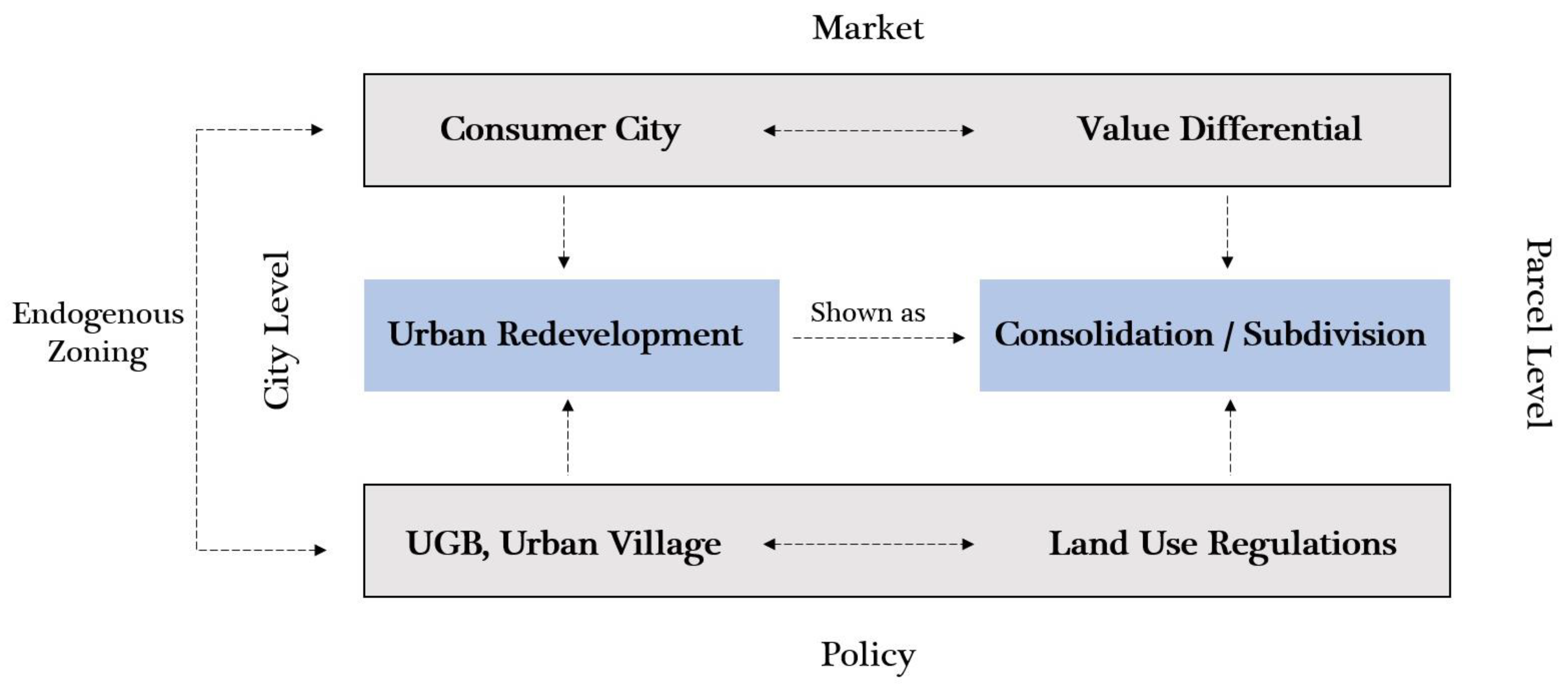
2.1. Urban Containment vs. Consumer City

To begin, the idea of urban containment can be traced back to Garden Cities of Tomorrow by Ebenezer Howard in 1898, where he proposed self-contained communities contained by green belts. Over the past several decades, urban containment has been implemented in U.S. cities to promote compact, mixed-use urban form. In 1973, Oregon passed the Oregon Land Use Act, with an emphasis on urban containment and compact development [11]. Oregon’s legislation, on which Washington’s is based, restricts urban development from occurring outside the state’s urban growth boundaries [1]. Oregon is also notable because its framework was the first to make the leap from urban growth control strategy to a comprehensive growth management strategy [7,12]. In 1990, Washington enacted the GMA, mandating cities to develop comprehensive plans aimed at managing growth. Importantly, the very first goal of the GMA is to achieve concentrated urban growth, or compact development patterns [13]. This idea of concentrating and designating urban growth is introduced in the following content of urban village policy.
Empirical studies have tested the effectiveness of various urban containment policies on urban redevelopment. Dawkins and Nelson [14] found that state growth management programs may promote residential construction activity within urban areas. Nelson and Sanchez [15] used a cross-sectional analysis of American metropolitan areas and found that those pursuing what were labeled “strong” containment efforts performed best in terms of reducing exurbanization. In this study, “strong” containment efforts were defined as those that direct development within UGBs and restrict development from occurring outside of them. Hortas-Rico [16] showed that the urban containment policies have helped to reduce city blight. Carruthers and Clark [17] looked at the single-family housing market in King County and found edge effects of urban containment in Seattle’s single-family housing market. The focus of that study was not on UGBs, but Figure 2, new graphs (not previously reported) based on the same data, shows the edge effects of the UGB via the single-family housing market. In short, the data show that the distance from the UGB in either direction has a positive effect, indicating that it is a fault line in the regional housing market, similar to edge effects reported by Knaap and Nelson [1]. The individual charts show, against distance from downtown Seattle, the natural logarithms of: (a) sales price; (b) sales price per square foot; (c) lot size, in square feet; (d) price per square foot and lot size, together; (e) neighborhood (census tract) median housing value; and (f) neighborhood density.
Next, the rise of the consumer city has led to the densification and revitalization of urban areas, raising the question of policy versus market forces. Despite the containment policies, some believe in the market’s force of densifying urban areas to help achieve the containment goals. Bertaud [18] argued that the market creates order without design. He believed that while urban planners often try to limit density, land price is a more influential determinant. As Glaeser et al. [9] noted, cities, as centers of consumption, provide many urban amenities; they also pointed out the importance of density in facilitating consumption. On the other hand, the idea of endogenous zoning argues that zoning appears to follow the market [10]. Thus, whether the current densification and redevelopment result from urban containment policy or market force remains an open question. In addition, previous theoretical studies have investigated the role of a “value differential” in urban redevelopment decision making [19,20,21].

2.2. Urban Redevelopment

Meanwhile, studies have explored different indicators for redevelopment activities, such as parcel changes (this research only focuses on vector data using parcel layers; other studies also apply raster data (see: [22,23])) [24,25,26], building or demolition permits [3,27,28], and surveys of developers [29]. Kwon et al. [6] studied the causes of demolition or redevelopment of hanoks (traditional Korean houses) using a probit model based on parcel-level datasets. They found out that the characteristics of parcels, neighborhood, and urban-scale factors may affect the redevelopment of hanoks. Longo and Campbell [30] added a spatial factor into their study: they used a spatial discrete choice model based on the geospatial data and land-use database and found that the determinants of brownfields vary in different locations and that the adjacent sites’ reuse decisions also have an impact on the reuse of the site. In addition to the spatial relationship between parcels, previous research has also looked into certain policy areas and their effects on redevelopment. A recent research study [5] explored the determinants of land redevelopment in Shenzhen, China. It discovered the different effects in SEZ and non-SEZ areas were due to ‘the institutional differences and development conditions’ between these two areas. Lewis [3] investigated the determinants of a parcel receiving building permits for renovation. Her findings show that many policy areas have a positive impact on the probability of renovation.
Parcel changes, such as subdivisions and consolidations, have been used as the indicator for urban redevelopment. Zhou and Kockelman [24] built a land-use model based on the parcel changes between 1995 and 2000 in Austin, Texas. They focused on parcel subdivisions in undeveloped parcels, but they did not look into the impact of the social-economic characteristics of the neighborhoods. Gallagher et al. [25] looked at parcel amalgamation in redevelopment as a solution to urban sprawl and densification in Australia. As they noted, this requires ‘a transformation of the dwelling types’, ‘or transformation of the urban structure and form of the city’. Nevertheless, their studies did not include quantitative empirical data analysis. Fredrickson et al. [26] detected the parcel subdivision (aggregation) and consolidation (amalgamation) in Auckland’s urban area between 2004 and 2014. The redevelopment through parcel changes resulted in higher dwelling densities than other developments. As interesting as the results are, they did not apply statistical models, rather, only stylized facts.
Missing from the current literature is a holistic approach that looks into subdivision and consolidation together as the determinants of redevelopment. In addition, a study on parcel-level changes and determinants of urban redevelopment has never been conducted in Seattle, which, as noted, is a natural laboratory that represents the implementation of urban containment policy at both the state level and local level with a very generalizable lesson to offer to other cities in terms of containment, densification, and redevelopment. Thus, it is crucial to conduct a study on Seattle that sorts out the numbers and policies and examines the possible determinants behind all these. It tests the hypothesis that urban containment, in the form of urban village policy, is related to urban redevelopment, shown as parcel changes.

3. Study Area

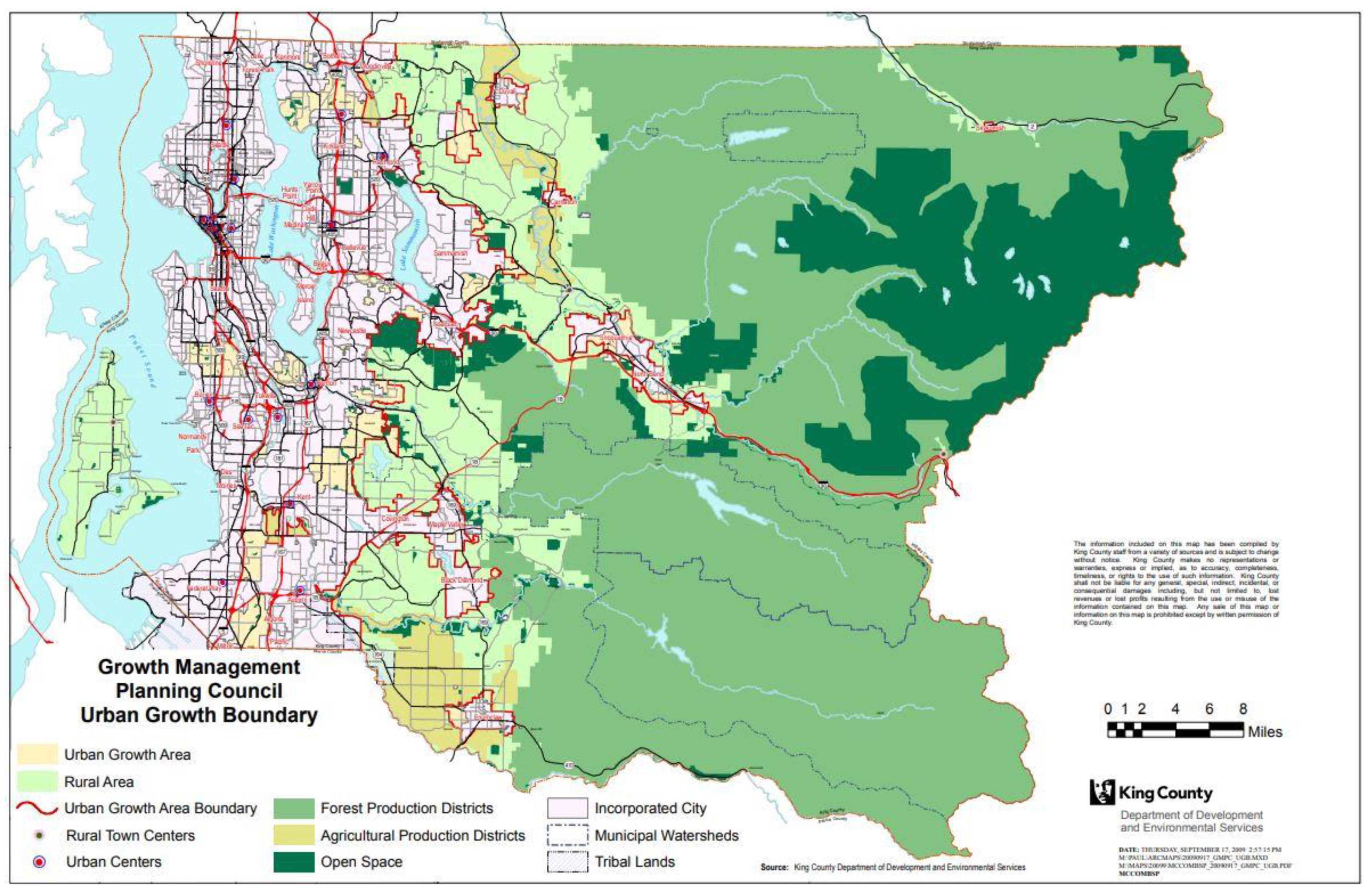
3.1. The Puget Sound Region

There has been remarkable economic and population growth in the Puget Sound Region. The Seattle metropolitan area is in the Puget Sound Region and is one of the largest metropolitan areas in the United States. It is composed of three counties, including King County, where Seattle is located. The economic pressure on the city over the past two decades is documented in Table 1, which lists population, real GDP, and per capita GDP for the Puget Sound Region and King County. The left-hand side of the table shows the numbers themselves and the right-hand side shows the numbers for King County as percentages of: (i) the Puget Sound; and (ii) their own starting values. King County has consistently held more than half (~55%) of the Puget Sound’s population and accounted for three quarters (~75%) of its productivity, placing its per capita GDP at about a third over (~133%) that of the region as a whole. Meanwhile, since 2001, the county’s population has increased by nearly a third (~129%) and its GDP has doubled (~192%), raising its per capita GDP by half (150%).

3.2. Seattle

Seattle, the heart of the Puget Sound Region, is one of the most important American cities and, also, one of the most attractive. Among other good things, the city is known for its stunning natural beauty, high quality of life, extraordinary human capital, and rich popular culture. Over its distinguished history, the so-called Emerald City has served, via its proximity to Asia, as a key maritime port and, as home to Boeing, the chief of the North American aerospace industry. More recently, the Puget Sound has reinvented itself as a tech juggernaut, with a massive agglomeration economy anchored by Microsoft, Amazon, and other global companies. (Seattle has the headquarters of large IT companies [31], and large innovative companies are seeing tremendous investment growth [32], including life sciences industry in Seattle [33]. The economic influence of large company headquarters will continue to increase in the future [34].) All the while, Seattle has remained at the center, growing and changing through path-breaking urban planning and environmental policy. Its approach stems, in large part, from the state’s GMA, which established a multi-jurisdictional urban growth boundary (UGB) intended to direct development inward and upward, particularly within Seattle.

3.3. Seattle’s Urban Growth Management

This study looks into urban containment by focusing on the Urban Village Element of the Seattle Comprehensive Plan, adopted in 2020 [35]. As mentioned above, Seattle is subject to numerous levels of urban containment policy, including those legislated by the state, county, and municipality. As required by the GMA, communities in King County have set up the UGB in its earlier comprehensive plans (see Figure 3).
In addition to its external urban growth boundary, the City of Seattle created its Urban Village Element as a way to predict, manage, and control future growth, allowing densification and population increases to occur symbiotically with the current built environment (see Figure 4). The Element designates six high-density urban centers—or miniature central business districts—and twenty-four urban villages as primary, localized areas to absorb future housing and job growth. Within the twenty-four urban villages, the Comprehensive Plan also identifies separate levels of containment and development expectations for its twenty-four urban villages, dividing them among six hub urban villages—Lake City, North Rainier, Bitter Lake Village, Ballard, West Seattle Junction, and Fremont—and eighteen residential urban villages. Where residential urban villages have largely been developed as single-use districts catering to commuters, hub urban villages have been designed as self-sustaining, mixed-use pods of medium-density development. Hub urban villages concentrate new residential and commercial development within several transit-accessible hubs in an effort to reduce commute times and create a polycentric growth pattern [36].
Seattle’s urban village strategy has been successful over the past twenty-some years at promoting vibrant development symbiotic with the character of the Emerald City, even under the limitations posed by the GMA-mandated growth boundary—‘over 75 percent of the city’s new housing and new jobs were located inside the urban centers and villages that together make up only about 17 percent of the city’s total land area’ [35]. According to Seattle’s Comprehensive Plan, there is an ambitious goal of development within urban centers and urban villages, which are prescribed to accommodate 70,000 housing units and 115,000 jobs; beyond these targets, the Urban Village Element clearly discusses the need to set aside plentiful land for open-space preservation, greenspace, and forestry as complements to new urban growth. This strategy of designating urban centers and urban villages has enabled Seattle to manage its urban growth—while keeping the character of the city intact—by encouraging compact and mixed-use development in specific, targeted areas.

4. Model Implementation

4.1. Data

This study is conducted at the parcel level of Seattle. Data used for this study include parcel datasets of year 2010 and year 2020 obtained from the Assessors’ Office in Seattle. The two parcel datasets were compared in order to determine where the parcel changes happen. The analysis also makes use of the latest land-use dataset from the City of Seattle Zoned Development Capacity Model in Seattle’s GeoData website. The 2020 parcel dataset and the parcel changes are integrated with the land-use dataset. All socio-economic explanatory variables come from the American Community Survey (ACS) obtained from the U.S. Census at the block group level. Five-year estimates of year 2010 and the latest available, for 2019, were used.

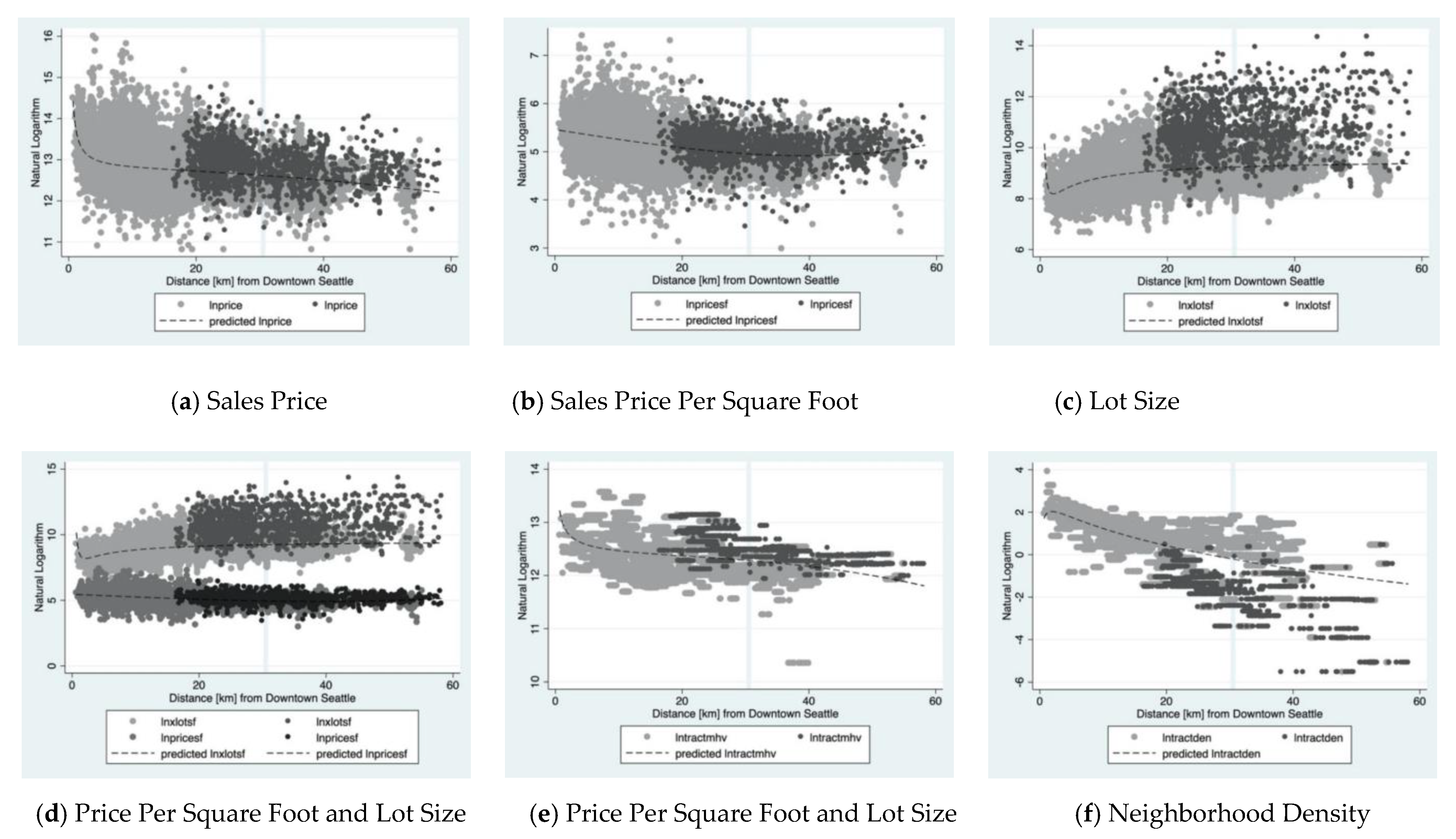
4.2. Preliminary Analysis for the Model

After the datasets were cleaned, as described below, Table 2 shows the distribution of parcels for different urban villages. (The urban center and urban center village belong to the larger category of urban center.) The majority of the parcels (82.44%) are outside urban villages. Residential urban villages have the largest number of parcels among other urban villages, and urban centers have the smallest number of parcels. From just a glance at the urban village plan (see Figure 4), we can tell that residential urban villages, even though their total areas do not seem to be much larger than those of urban centers and urban hubs, have a much larger number of parcels.
Changes in parcels are used as the indicator for redevelopment activities. As mentioned in Section 2.2, using parcel changes is only one way of detecting urban redevelopment activities. Even though development activities can happen without parcel changes, the change of parcel boundaries represents a large part of the process, often involving demolishment of previous buildings and new construction, indicating a high redevelopment intensity.
The changes in these parcels between 2010 and 2020 are compared via a geospatial analysis. This analysis divides the changes in parcels into three types: parcel consolidation, parcel subdivision, and parcel boundary changes. Since each parcel has its own PIN, or parcel identification number, it is possible, with care, to detect changes from 2010 to 2020—in particular, whether parcels have been subdivided, merged into a larger parcel, or have simply changed their geographical boundaries to some extent. For the last scenario, a five-meter threshold was used to detect the boundary changes—if the centroid of the parcel has changed its location by over five meters, its boundary is considered to have changed. By setting up this threshold, the analysis is able to offset the bias caused by the parcel boundary data collection process. In addition, sometimes several parcels can share one PIN—in which case they are taken to be one parcel. This is why, in Table 3, it can be seen that the total number of parcels is different from the total number of parcel PINs. However, there is only a small number of different parcels that share one PIN.
As shown in Table 3, there have been a lot of activities, consolidating and subdividing parcels, but, critically, parcel subdivision is the predominant form of creating new houses. Between 2010 and 2020, 8965 new parcels were added and 1247 parcels disappeared. Most of the missing parcels from 2010 have been consolidated into bigger parcels in 2020. Most of the new parcels in 2020 come from the subdivision of older parcels. Comparing the two numbers reveals more parcel changes occurred from subdivision than from consolidation. This surprising outcome strongly suggests to the present authors that it is the result of the joint force of planning and market working together.
The large amount of parcel changes over the past decade shows the intensity of redevelopment activities in Seattle. The total number of parcel changes is calculated by adding new parcels, disappeared parcels, and parcels with boundary changes. As we can see, there is an 8% ratio of parcel changes in 2020, which accounts for 12,454 parcel changes. Detailed spatial distribution is shown in Figure 5.
Parcel changes were spatially joined with a current land-use map and used to summarize the parcel changes in different zoning areas. Due to the different accuracy levels of different data sources, the parcel dataset in 2020 is slightly different from the parcel information in the land-use dataset. In the following content, the analysis is based on the parcel information in the land-use dataset. In addition to this, only privately owned land was kept in this research. After cleaning the dataset, a total number of 165,426 observations were left available for this model.
As shown in Table 4, it is evident that most of the changes are located in areas that are currently zoned as single or multifamily residential land use in 2020. Single-family land use and multifamily land use have the largest number and the highest ratio of parcel changes. Most parcel changes happened in single-family land use with a minimum lot size of 5000 square feet (Residential, Single-family 5000). Land use with intended primary building type as two- to three-story apartment buildings or townhouses (Residential, Multifamily, Low-rise 2 (detailed definition of multifamily zones can be seen here: Recommendations for New Multifamily Zones Concept Report. (2006). https://www.seattle.gov/Documents/Departments/OPCD/Vault/Multifamily/MultifamilyConceptReport.pdf, accessed on 15 January 2021)) has the second largest number of parcel changes. Regarding the ratio of parcel changes, land use with intended primary building type as two to three-story duplexes, triplexes, and townhouses (Residential, Multifamily, Low-rise 1) has the highest ratio of 30.49%, which is almost one-third of the total parcels in this category. Generally, the single-family land-use types have a lower change ratio compared to multifamily land-use types. This shows that a large amount of redevelopment activities for multifamily houses have happened in the past decade, indicating considerable residential density increase, which may also be the evidence of compact and mixed-use neighborhood development.
In the following model—which is exploratory, not definitive—there is a binary dependent variable registering if a parcel has changed (=1) or not (=0) in the past ten years. Some explanatory variables for the model are from the City of Seattle Zoned Development Capacity Model. These variables include whether the parcel is a landmark or not, the land-use type, the year the building was built, which urban village the parcel is in or not, and the development ratio. The development ratio is a ‘ratio of what exists to what could be developed’. The higher value of this variable means the more developed the parcel is. The social-economic explanatory variables are shown in Table 5. For the land-use variables, we used a simpler version of the land-use type, shown in Table 6. For urban village variables, there is a general binary variable indicating whether the parcel is inside an urban village or not. There are also five categories of urban village types and a category of outside village.

4.3. Model

Since the variable of interest—whether the parcel has changed or not—is dichotomous, a linear regression is not an option. Thus, a probit/logit model should be used instead to evaluate its relationship with the independent variables. Since the logit model is limited in several important ways [37], this study elected to use a probit model under the assumption of normal distribution of all latent variables. The probit model is quite general when this assumption is not violated [37].
Probit is also a common analytical tool that has been widely implemented in urban studies. For example, Longo and Campbell [30] investigated the reuse decisions of brownfields in England using a spatial probit model; Yates and Mackay [38] reviewed the housing choice literature and used a discrete choice model to study the housing market in Sydney, Australia; and Lewis [3] used a probit model to investigate how a parcel receives a renovation building permit based on the certain characteristics of the parcel and the neighborhood and location. Similar to this research, Kline and Alig [39] used a probit model of land use to examine how effective growth management in Oregon has been at protecting forests and farmland.
In this analysis, Yi is a binary (1/0) variable that describes whether or not a parcel has changed, registering value 1, if yes, or 0, if no. Yi* is the latent variable expressed in a linear function of the characteristics of the parcel:
Yi* = Xβ + ei, ei ~ N(0,1),
Y i = { 1           if     X β + ei > 0   0               otherwise
The probability Pr(X) that an alternative is chosen, Yi = 1, is:
Pr(Yi = 1|X) = Pr[Yi* > 0|X] = Pr[−ei ≤ Xβ|X] = Φ(Xβ)
where Φ(Xβ) is the standard normal cumulative distribution function (cdf). While the probability of Yi = 0 is:
Pr(Yi = 0|X) = 1 − Pr(Yi = 1|X)
For further details, see: [40,41,42,43,44].
Equation (1) was estimated twice, with a single urban village variable (1a) and the urban village variable broken down by type (1b). The results are provided in Table 7. An overarching finding is that urban villages are not, in general, associated with concentrated redevelopment. However, a more mixed land use with housing and employment may promote redevelopment. What is more, parcel changes are more likely to yield multifamily housing. The details are summarized in the following section.

5. Empirical Findings

5.1. The Effectiveness of Urban Village Policy

Urban village indicator in (1a) has a negative effect on urban redevelopment, but in (1b), the hub urban village indicator carries a positive sign. Table 7 shows that the effect of being located in an urban village is significantly negative. This is contradictory to the initial expectation—urban villages in Seattle’s city plans are designated areas for urban growth. This may also indicate that urban village policy overall may not promote redevelopment activities that involve parcel changes. Another explanation is that urban village designations are consistent with the current urban developed areas, thus leaving fewer opportunities for redevelopment, which leads to the negative coefficient. As mentioned above, the urban village policy can also result from an endogenous zoning effect, wherein land-use policy follows the market. As stated in policy documents [36], urban village designations were shaped to ‘fit Seattle’s established, densely developed, and complex urban neighborhoods’. In this case, it is sensible that parcels within an urban village are less likely to be redeveloped. Using “outside village” as the reference level, the result, in (1b), is that hub urban villages are more likely to contain parcel changes. The rest of the urban village types—including residential urban village, urban center, and urban center village—are less likely to have parcel changes compared to “outside village”. The distinct characteristics of hub urban villages compared to urban centers and residential urban villages may be the reason for this positive effect on redevelopment. The marginal effect estimated by the model is not that large, which means whether the parcel is within the urban villages does not have great bearing on the probability of redevelopment. In addition, as mentioned before, this analysis only deals with the redevelopment activities through parcel changes—an analysis of redevelopment without parcel changes may yield different results.

5.2. Parcel Changes in Multifamily Land Use

It is more likely for a parcel to change if it belongs to the multifamily land-use category and less likely for a parcel to change if it belongs to the single-family land-use category. This finding makes perfect sense: as noted in the introduction, single-family housing, usually the most protected of all land uses, is notoriously stubborn to change. Using commercial land use (C) as the reference level, the estimates show that multifamily low-rise land use is the only land use that has a positive impact on the probability of a parcel changing. This result is statistically significant in both models. This land-use designation also has the largest magnitude of discrete change effect compared to other land-use types. The fact that parcels in multifamily land use are more likely to change may come from the need for larger-scale multifamily buildings. In addition, since outside village areas consist primarily of single-family houses, this result may be interpreted as evidence that Seattle’s planning strategy has been successful in directing growth away from single-family areas.

5.3. Social and Other Factors

Specific socio-economic characteristics show some statistically significant and analytically interesting results. Neighborhoods having a denser population are less likely to go through parcel changes, while population density increase has a significant positive impact on the probability of parcel changes. Similarly, higher-income neighborhoods are more likely to have parcel changes. Neighborhoods with a greater percentage of African American residents in 2010 and those experiencing an increase in it are more likely to have parcel changes. As urban village strategy in Glasgow is criticized as a poor example of sustainable and socially inclusive redevelopment [45], whether urban village in Seattle has led to social inequality among different demographic groups is a question that merits further exploration.
Parcel size has a positive influence: a current large parcel is more likely to have experienced change in the past ten years, which is sensible. The more the parcel is developed, as measured by the development ratio, the less likely it has changed in the past decade. In other words, the places that still have a prospect of development are more likely to experience changes in the past ten years. The distance to the city center (Pike Market) also matters significantly—the further it is from the city center, the less likely it has experienced changes. This shows that overall parcel changes happened in central urban areas. Since we use the 2020 land-use data, the coefficients of land-use-related variables show the relationship between current land use and past parcel change activities.

6. Discussion and Conclusions

6.1. Limitations

This study has several limitations. First, the probit model results are very preliminary—many other variables are not included in this model. More built environment factors can be added to the model in the next step. For instance, Seattle is a hilly city. Thus, the topography is also an essential factor in affecting the redevelopment activities. Second, this study only discusses the redevelopment activities in the form of parcel changes. For other kinds of redevelopment activities without changing parcels, there could be different results in the model. Third, there is a collinearity issue between the various variables. For instance, the land-use type and the urban village may be related. Some urban villages are in the city centers with a lot of commercial or mixed-use land. Some urban villages are mostly residential land. The coefficients of this model can be more accurate if the collinearity issue is solved. Fourth, this study uses the current land-use data—it would work better if we could obtain land-use data from 2010. Land-use data from 2020 show, for the current land-use types, the changes in parcels that have happened; land-use data from 2010 can show the relationship between the initial land-use types with the parcel changes, which is better. In addition, this study does not discuss the land-use changes in the past ten years. Last but not least, spatial correlation can be considered in the next steps. These limitations can be addressed and improved in future analyses.

6.2. Implications for Urban Planning

When making urban growth management strategies, urban planners need to understand and work with the power of the market toward a more sustainable future. On the one hand, Seattle shows an example for global cities how to promote future growth through urban planning strategies. In general, the changes of parcels are market activities driven by profits. With the influence of various urban village policies, the redevelopment activities in Seattle have shown a preference for a more mixed-use and compact urban living style, which aligns with urban planners’ goal for sustainable growth. On the other hand, urban planning policies also need to accommodate the emerging needs from the market and adjust the growth management strategy accordingly, such as supporting the future growth driven by the market.

6.3. Conclusions

To conclude, the urban village strategy works in terms of densifying urban areas, but it indicates that among all types of urban villages, only hub urban village has successfully designated urban growth within it during the past decade, while the overall negative effect of urban village can be explained by endogenous zoning. By looking into parcel changes, this study shows how market and planning work together in Seattle to accommodate its urban growth in the past decade. We can see that very intense urban redevelopment activities involving parcel changes have happened in the last ten years. Apparently, Seattle has a large number of parcel subdivisions rather than parcel consolidations toward densifying the urban areas. Many of the parcel changes were for multifamily and single-family housing development. Multifamily land use is most likely to have parcel changes, indicating a successful densification strategy of designating urban growth away from single-family areas.
Since there is a regional discrepancy between different programs [12] and a difference in evaluation of the effectiveness of urban growth management, the result of an overall negative impact in this study can be contradictory with some other studies. For instance, Long et al. [46] showed a quite effective UGB policy in Beijing in containing ‘human activities’. Dawkins and Nelson’s [14] empirical results also show that state growth management policies may have an overall positive effect on the redevelopment of central cities. Since this study focuses on a different geographical area, uses a more recent time frame, and only investigates parcel-changes-indicated redevelopment, the different conclusions will need further exploration.
Nevertheless, this study is consistent in illustrating the different effects on development in/outside of certain policy areas. For instance, Lai et al. [5] showed that the effects of factors such as location and land-use status are different in the special economic zone (SEZ) and non-SEZ. Lewis [3] found that many policy areas have either positive or negative impact on the probability of renovation in Baltimore City. The magnitude of the impact of policy is small [3], which is also the same with this study.
This research also indicates that mixed land use may lead to more redevelopment, such as the case of the hub urban village. As indicated by our title ‘planning and markets at work’, even though developers are only driven by the market profit, their preference for mixed land use aligns with urban planners’ goal for a mixed-use neighborhood and a sustainable future. While the urban policies are shaping the market, it should also be recognized that this policy influence not only comes from a single urban village policy but also results from multi-scalar policy efforts toward diverse urban sustainability visions [47].
However, the unbalanced redevelopment in the hub urban village compared to other types of urban villages may further indicate an unbalanced growth distribution within single urban villages. This leads to our further question of the implementation of urban village policy, such as how it should be improved in the future accordingly.

Author Contributions

Conceptualization, H.W., L.C.W. and J.I.C.; methodology, J.I.C. and H.W.; software, H.W.; formal analysis, H.W. and J.I.C.; investigation, H.W., L.C.W. and J.I.C.; resources, J.I.C.; data curation, H.W.; writing—original draft preparation, H.W., L.C.W. and J.I.C.; writing—review and editing, H.W., L.C.W. and J.I.C.; visualization, H.W.; supervision, J.I.C.; funding acquisition, J.I.C. All authors have read and agreed to the published version of the manuscript.

Funding

This research was funded by Cornell Center for Social Science Grant.

Conflicts of Interest

The authors declare no conflict of interest.

References

  1. Knaap, G.; Nelson, A.C. The Regulated Landscape: Lessons on State Land Use Planning From Oregon; Lincoln Institute of Land Policy: Cambridge, MA, USA, 1992. [Google Scholar]
  2. Lynch, K. Theory of Good City Form; The MIT Press: Cambridge, MA, USA, 1981. [Google Scholar]
  3. Lewis, R. The determinants of renovation and redevelopment in Baltimore City. Reg. Sci. Policy Pract. 2012, 4, 335–354. [Google Scholar] [CrossRef]
  4. Boarnet, M.G.; McLaughlin, R.B.; Carruthers, J.I. Does State Growth Management Change the Pattern of Urban Growth? Evidence from Florida. Reg. Sci. Urban Econ. 2011, 41, 236–252. [Google Scholar] [CrossRef] [Green Version]
  5. Lai, Y.; Tang, B.; Chen, X.; Zheng, X. Spatial determinants of land redevelopment in the urban renewal processes in Shenzhen, China. Land Use Policy 2021, 103, 105330. [Google Scholar] [CrossRef]
  6. Kwon, Y.; Kim, S.; Jeon, B. Unraveling the factors determining the redevelopment of Seoul’s historic hanoks. Habitat Int. 2014, 41, 280–289. [Google Scholar] [CrossRef]
  7. Carruthers, J.I.; Wei, H.; Wostenholme, L.C. Urban Containment as Smart Growth: The Evolution and Future of an Enduring Policy Concept. In A Handbook on Smart Growth; Knaap, G.-J., Lewis, R., Chakraborty, A., Eds.; Edgar Elgar Press: Cheltenham, UK, 2021. [Google Scholar]
  8. Glaeser, E.L.; Nathanson, C.G. Housing bubbles. In Handbook of Regional and Urban Economics; Elsevier: Amsterdam, The Netherlands, 2015; Volume 5, pp. 701–751. [Google Scholar]
  9. Glaeser, E.L.; Kolko, J.; Saiz, A. Consumer city. J. Econ. Geogr. 2001, 1, 27–50. [Google Scholar] [CrossRef]
  10. Pogodzinski, J.M.; Sass, T.R. The theory and estimation of endogenous zoning. Reg. Sci. Urban Econ. 1994, 24, 601–630. [Google Scholar] [CrossRef]
  11. Big Look Task Force. Oregon Task Force on Land Use Planning: Final Report to the 2009 Oregon Legislature. Available online: https://www.oregon.gov/lcd/OP/Documents/Big_Look_Report.pdf (accessed on 15 January 2021).
  12. Carruthers, J.I. The impacts of state growth management programmes: A comparative analysis. Urban Stud. 2002, 39, 1959–1982. [Google Scholar] [CrossRef]
  13. Growth Management Act. 2021. Available online: http://mrsc.org/Home/Explore-Topics/Planning/General-Planning-and-Growth-Management/Comprehensive-Planning-Growth-Management.aspx (accessed on 15 January 2021).
  14. Dawkins, C.J.; Nelson, A.C. State growth management programs and central-city revitalization. J. Am. Plan. Assoc. 2003, 69, 381–396. [Google Scholar] [CrossRef]
  15. Nelson, A.C.; Sanchez, T.W. The effectiveness of urban containment regimes in reducing exurban sprawl. disP-Plan. Rev. 2005, 41, 42–47. [Google Scholar] [CrossRef]
  16. Hortas-Rico, M. Sprawl, blight, and the role of urban containment policies: Evidence from US cities. J. Reg. Sci. 2015, 55, 298–323. [Google Scholar] [CrossRef] [Green Version]
  17. Carruthers, J.I.; Clark, D.E. Valuing environmental quality: A space-based strategy. J. Reg. Sci. 2010, 50, 801–832. [Google Scholar] [CrossRef] [Green Version]
  18. Bertaud, A. Order without Design: How Markets Shape Cities; The MIT Press: Cambridge, MA, USA, 2018. [Google Scholar]
  19. Harvey, D. The Urban Experience; Johns Hopkins University Press: Baltimore, MD, USA, 1989. [Google Scholar]
  20. Rosenthal, S.S.; Helsley, R.W. Redevelopment and the urban land price gradient. J. Urban Econ. 1994, 35, 182. [Google Scholar] [CrossRef]
  21. Weber, R.; Doussard, M.; Bhatta, S.D.; McGrath, D. Tearing the city down: Understanding demolition activity in gentrifying neighborhoods. J. Urban Aff. 2006, 28, 19–41. [Google Scholar] [CrossRef] [Green Version]
  22. Hu, S.; Tong, L.; Frazier, A.E.; Liu, Y. Urban boundary extraction and sprawl analysis using Landsat images: A case study in Wuhan, China. Habitat Int. 2015, 47, 183–195. [Google Scholar] [CrossRef]
  23. García-Ayllón, S. Predictive diagnosis of agricultural periurban areas based on territorial indicators: Comparative landscape trends of the so-called “Orchard of Europe”. Sustainability 2018, 10, 1820. [Google Scholar] [CrossRef] [Green Version]
  24. Zhou, B.; Kockelman, K.M. Neighborhood impacts on land use change: A multinomial logit model of spatial relationships. Ann. Reg. Sci. 2008, 42, 321–323. [Google Scholar] [CrossRef] [Green Version]
  25. Gallagher, R.; Liu, Y.; Sigler, T. Parcel amalgamation as a mechanism for achieving urban consolidation through densification: The fixity of property boundaries over time. Land Use Policy 2019, 89, 104239. [Google Scholar] [CrossRef]
  26. Fredrickson, C.; Fergusson, E.; Wildish, B.R. Residential Property Amalgamation and Aggregation in Auckland, 2004–2014; Auckland Council, Te Kaunihera o Tāmaki Makaurau. 2016. Available online: https://knowledgeauckland.org.nz/publications/residential-property-amalgamation-and-aggregation-in-auckland-2004-2014/ (accessed on 15 January 2021).
  27. Helms, A.C. Understanding gentrification: An empirical analysis of the determinants of urban housing renovation. J. Urban Econ. 2003, 54, 474–498. [Google Scholar] [CrossRef]
  28. Charles, S.L. Understanding the determinants of single-family residential redevelopment in the inner-ring suburbs of Chicago. Urban Stud. 2013, 50, 1505–1522. [Google Scholar] [CrossRef]
  29. Alberini, A.; Longo, A.; Tonin, S.; Trombetta, F.; Turvani, M. The role of liability, regulation and economic incentives in brownfield remediation and redevelopment: Evidence from surveys of developers. Reg. Sci. Urban Econ. 2005, 35, 327–351. [Google Scholar] [CrossRef] [Green Version]
  30. Longo, A.; Campbell, D. The determinants of brownfields redevelopment in England. Environ. Resour. Econ. 2017, 67, 261–283. [Google Scholar] [CrossRef] [Green Version]
  31. Raźniak, P.; Dorocki, S.; Winiarczyk-Raźniak, A. Innovative Industry Sectors in World Economic Center. In Proceedings of the 5th International Conference IMES, Prague, Czech Republic, 25–26 May 2017. [Google Scholar] [CrossRef]
  32. Dorocki, S.; Raźniak, P.; Winiarczyk-Raźniak, A.; Boguś, M. The Role of Global Cities in Creation of Innovative Industry Sectors. Case Study—Life Sciences Sector. Available online: https://www.ceeol.com/search/chapter-detail?id=544095 (accessed on 15 January 2021).
  33. Bochniarz, Z. Life Sciences Cluster in Seattle in Washington State. In Social Capital in the University-Based Innovation Ecosystems in the Leading Life-Science Clusters: Implications for Poland; Runiewicz-Wardyn, M., Ed.; 2020; pp. 127–149. Available online: https://journals.kozminski.edu.pl/pub/5907 (accessed on 15 January 2021).
  34. Raźniak, P.; Dorocki, S.; Winiarczyk-Raźniak, A. Changes in the Rank of World Economic Centers in the United States—Present State and Perspectives. In Proceedings of the 2018 4th International Scientific Conference Geobalcanica, Ohrid, Republic of Macedonia, 15–16 May 2018. [Google Scholar] [CrossRef]
  35. Seattle Comprehensive Plan. 2020. Available online: http://www.seattle.gov/Documents/Departments/OPCD/OngoingInitiatives/SeattlesComprehensivePlan/CouncilAdopted2020.pdf (accessed on 15 January 2021).
  36. Seattle’s Comprehensive Plan Urban Village Element. 2005. Available online: https://www.seattle.gov/Documents/Departments/OPCD/OngoingInitiatives/SeattlesComprehensivePlan/UrbanVillageElement.pdf (accessed on 15 January 2021).
  37. Train, K.E. Discrete Choice Methods with Simulation; Cambridge University Press: Cambridge, UK, 2009. [Google Scholar]
  38. Yates, J.; Mackay, D.F. Discrete choice modelling of urban housing markets: A critical review and an application. Urban Stud. 2006, 43, 559–581. [Google Scholar] [CrossRef]
  39. Kline, J.D.; Alig, R.J. Does land use planning slow the conversion of forest and farmlands? Growth Chang. 1999, 30, 3–22. [Google Scholar] [CrossRef]
  40. Hill, R.C.; Griffiths, W.E.; Lim, G.C. Principles of Econometrics; John Wiley and Sons: Hoboken, NJ, USA, 2018. [Google Scholar]
  41. Greene, W.H. Econometric Analysis, 4th ed.; International Edition; Prentice Hall: Hoboken, NJ, USA, 2000; pp. 201–215. [Google Scholar]
  42. Wooldridge, J.M. Introductory Econometrics: A Modern Approach; Cengage Learning: Boston, MA, USA, 2009. [Google Scholar]
  43. Aldrich, J.; Nelson, H.; Forrest, D. Estimation of probit and logit models for dichotomous dependent variables. In Linear Probability, Logit, and Probit Models; Sage Publications: Beverly Hills, CA, USA, 1984. [Google Scholar]
  44. Carruthers, J.I.; Duncan, N.T.; Waldorf, B.S. Public and subsidized housing as a platform for becoming a United States citizen. J. Reg. Sci. 2013, 53, 60–90. [Google Scholar] [CrossRef]
  45. McArthur, A. Rebuilding sustainable communities: Assessing Glasgow’s urban village experiment. Town Plan. Rev. 2000, 71, 51–69. [Google Scholar] [CrossRef]
  46. Long, Y.; Han, H.; Tu, Y.; Shu, X. Evaluating the effectiveness of urban growth boundaries using human mobility and activity records. Cities 2015, 46, 76–84. [Google Scholar] [CrossRef]
  47. Dierwechter, Y. Urban Sustainability through Smart Growth: Intercurrence, Planning, and Geographies of Regional Development across Greater Seattle; Springer: New York, NY, USA, 2017. [Google Scholar]
Figure 1. Theoretical framework of this study.
Sustainability 13 07634 g001
Figure 2. Edge Effects at the Puget Sound UGB.
Sustainability 13 07634 g002
Figure 3. Urban Growth Boundary in King County. Note: from “Growth Management Planning Council Urban Growth Boundary” by King County Department of Development and Environmental Services, 2009 (https://www.kingcounty.gov/property/permits/codes/growth/GMPC/~/media/property/permits/documents/GrowthManagement/CPP_ugb_gmpc_Map.ashx, accessed on 1 December 2020).
Sustainability 13 07634 g003
Figure 4. Seattle’s Urban Villages. Note: from “Seattle’s Comprehensive Plan”, 2020 (http://www.seattle.gov/Documents/Departments/OPCD/OngoingInitiatives/SeattlesComprehensivePlan/CouncilAdopted2020.pdf, accessed on 15 January 2020).
Sustainability 13 07634 g004
Figure 5. Parcel changes in Seattle from 2010 to 2020: new parcels (blue), disappeared parcels (orange), and boundary-changed parcels (purple). (a) Parcel changes shown in centroids, (b) parcel changes shown in boundaries, (c) Ballard area in Seattle, and (d) downtown area in Seattle.
Sustainability 13 07634 g005
Table 1. Population and economic growth in the Puget Sound, 2001–2019.
Puget Sound RegionKing County/SeattleKing County, % Puget SoundKing County, % 2001
PopulationGDPPC GDPPopulationGDPPC GDPPopulationGDPPC GDPPopulationGDPPC GDP
20013,092,927$199,619,567$64,5411,754,090$150,633,799$85,87656.71%75.46%133.06%100.00%100.00%100.00%
20023,118,302$200,297,457$64,2331,758,685$150,395,689$85,51656.40%75.09%133.13%100.82%100.34%99.52%
20033,133,021$203,266,418$64,8791,763,440$152,296,884$86,36456.29%74.92%133.12%101.30%101.83%100.52%
20043,158,967$207,319,154$65,6291,775,297$154,383,667$86,96256.20%74.47%132.51%102.14%103.86%101.69%
20053,198,265$221,612,161$69,2911,795,268$163,798,247$91,23956.13%73.91%131.67%103.41%111.02%107.36%
20063,257,081$230,116,812$70,6511,822,967$167,978,707$92,14655.97%73.00%130.42%105.31%115.28%109.47%
20073,304,467$246,628,564$74,6351,847,986$178,911,909$96,81555.92%72.54%129.72%106.84%123.55%115.64%
20083,355,042$250,289,363$74,6011,875,020$182,767,774$97,47555.89%73.02%130.66%108.47%125.38%115.59%
20093,414,797$242,211,495$70,9301,912,012$175,591,711$91,83655.99%72.50%129.47%110.41%121.34%109.90%
20103,449,241$247,960,025$71,8881,938,351$179,699,824$92,70856.20%72.47%128.96%111.52%124.22%111.38%
20113,503,891$256,144,097$73,1031,974,200$187,148,065$94,79756.34%73.06%129.68%113.29%128.32%113.27%
20123,558,829$268,999,178$75,5862,011,197$200,193,173$99,53956.51%74.42%131.69%115.06%134.76%117.11%
20133,612,347$278,715,088$77,1562,047,223$207,842,599$101,52456.67%74.57%131.58%116.79%139.62%119.55%
20143,675,160$290,986,145$79,1762,085,225$218,470,774$104,77156.74%75.08%132.33%118.82%145.77%122.68%
20153,739,654$306,164,721$81,8702,126,178$229,721,323$108,04456.85%75.03%131.97%120.91%153.37%126.85%
20163,816,355$318,450,834$83,4442,166,350$240,149,410$110,85456.76%75.41%132.85%123.39%159.53%129.29%
20173,885,579$337,774,548$86,9302,203,836$256,067,584$116,19256.72%75.81%133.66%125.63%169.21%134.69%
20183,935,179$364,252,252$92,5632,228,364$278,127,160$124,81256.63%76.36%134.84%127.23%182.47%143.42%
20193,979,845$382,789,623$96,1822,252,782$294,329,768$130,65256.60%76.89%135.84%128.68%191.76%149.03%
Note: The Puget Sound Region consists of King, Pierce, and Snohomish Counties; GDP is in constant (chained 2012) United States dollars; all data are from the BEA’s Regional Economic Information System.
Table 2. Descriptive statistics of categorical variables used in Model-1b.
Urban VillageNameNumber of 2020 ParcelsNumber of 2020 ParcelsPercentage
Urban CenterNorthgate31810780.65%
South Lake Union262
Uptown498
Urban Center VillageDowntown93843622.64%
First Hill–Capital Hill2238
University District1186
Hub Urban VillageBallard219051823.13%
Bitter Lake Village370
Fremont889
Lake City515
North Rainier1218
Residential Urban Village23rd and Union–Jackson247116,73110.11%
Admiral280
Aurora–Licton Springs1876
Columbia City1178
Crown Hill838
Eastlake732
Green Lake490
Greenwood–Phinney Ridge271
Madison–Miller800
Morgan Junction642
North Beacon Hill587
Othello1003
Rainier Beach536
Roosevelt713
South Park953
Upper Queen Anne154
Wallingford1339
West Seattle Junction811
Westwood–Highland Park1057
Manufacturing Industrial CentersBallard–Interbay–Northend53416951.02%
Greater Duwamish1161
Outside VillagesOutside Villages136,378136,37882.44%
TotalTotal165,426165,426100.00%
Table 3. Seattle parcel changes.
Seattle Parcel ChangesYear 2010Year 2020
Total number of parcel PINs176,836184,555
Total number of parcels176,779184,497
Total number of PINs in 2020 but not in 2010-8965
Total number of PINs in 2010 but not in 20201247-
Total number of PINs in both 2010 and 2020175,532
 Boundary changes (5 m threshold)5484
 Ratio of boundary changes3%
Total number of PIN changes673114,449
Total number of parcel changes673514,454
Ratio of parcel changes4%8%
Table 4. Parcel changes in different land-use zones (top 14).
ZoneAbbreviatedRank of ChangesTotal Parcel ChangesTotal Number of ParcelsRatio of Parcel Changes
Residential, Single-family 5000SF 500014047100,2874.04%
Residential, Multifamily, Low-rise 2LR222173965122.52%
Residential, Multifamily, Low-rise 1LR132094686830.49%
Residential, Multifamily, Low-rise 3LR341693984717.19%
Residential, Single-family 7200SF 72005133824,9815.36%
Residential, Single-family 9600SF 96006330236113.98%
Neighborhood Commercial 2NC27312236713.18%
Commercial 1C18237150615.74%
Neighborhood Commercial 3NC39195183210.64%
Neighborhood Commercial 1NC1109974813.24%
General Industrial 2IG2119710888.92%
Residential, Multifamily, Mid-riseMR129290710.14%
General Industrial 1IG1138639521.77%
Commercial 2C2146239715.62%
Table 5. Descriptive statistics of variables used in the model.
VariableMeanStd. Dev.Min.Max.
Parcel change0.080.2701
Parcel size7074.0220,963.1703,740,803.00
Landmark0.000.0401
Year from 202065.2332.965120.00
Development ratio0.900.63−1.0093.56
Dist. from city center (ln)10.040.465.5510.77
Urban village0.180.3801
Population density 10 (ln)8.920.605.5411.71
Median family income (ln)11.390.469.1612.43
% education 106.828.73046.01
% Native 100.681.74013.25
% Asian 1012.6514.29074.27
% Black 107.0411.34068.59
% Black change 10–19−0.778.15−56.7035.35
% Native change 10–190.212.28−13.2514.81
% Asian change 10–190.429.95−40.8465.02
n = 165,426
Table 6. Descriptive statistics of categorical variables used in the model.
Land-Use TypeNumber of PARCELS
SF (Single family)127,716
NC (Neighborhood commercial)5000
MR (Multifamily, mid-rise)973
L (Multifamily, low-rise)26,488
I (Industrial)1933
HR (Multifamily, high-rise)118
D (Downtown)938
C (Commercial)2260
Total165,426
Table 7. Maximum likelihood estimates of transition models.
(1a)(1b)
βMarg.zβMarg.z
Constant−0.186111 −0.78  0.375755 1.53
 Parcel Information
 Parcel Size  0.000001 ***0.00000026.75  0.000001 ***0.00000027.00
 Landmark−0.185170−0.0197167−1.56−0.165550−0.0178725−1.40
 Year From 2020−0.001559 ***−0.0001917−10.02−0.001626 ***−0.0001995−10.44
 Development Ratio−0.259072 ***−0.0318441−19.52−0.262473 ***−0.0322144−19.68
Land Use
 D−0.907741 ***−0.0556887−11.64−0.799361 ***−0.0530005−9.58
 HR−0.129668−0.0144165−0.80−0.013349−0.0016217−0.08
 I−0.696829 ***−0.0503602−12.77−0.581932 ***−0.0457716−5.24
 L  0.466801 ***0.072911913.57  0.460451 ***0.071601013.12
 MR−0.063696−0.0074583−0.98−0.001919−0.0002352−0.03
 NC−0.051865−0.0061402−1.30−0.023561−0.0028429−0.58
 SF−0.412899 ***−0.0603938−11.44−0.398897 ***−0.0579269−10.84
Location
 Ln (Dist. from City Center)−0.064536 ***−0.0079325−5.48−0.100016 ***−0.0122754−8.15
 Urban Village−0.038106 **−0.0045954−2.62
 Manufacturing Industrial Center −0.189814−0.0201606−1.66
 Hub Urban Village   0.117838 ***0.01572935.14
 Residential Urban Village −0.060763 ***−0.0071849−3.70
 Urban Center −0.330965 ***−0.0314595−6.11
 Urban Center Village −0.231142 ***−0.0239116−6.36
Neighborhood characteristics
 ln (Population Density 10)−0.142550 ***−0.0175217−16.87−0.138169 ***−0.0169581−16.06
 % Change in Population Density  0.000009 ***0.00000116.58  0.000010 ***0.00000126.71
Demographics
 ln (Median Family Income)  0.098293 ***0.01208186.98  0.086688 ***0.01063966.05
 % Education, 2010  0.003347 ***0.00041143.79  0.002953 **0.00036253.27
 % Native, 2010−0.010827 *−0.0013309−2.35−0.011088 *−0.0013609−2.39
 % Asian, 2010−0.002685 ***−0.0003300−5.04−0.002050 ***−0.0002517−3.79
 % Black, 2010  0.006489 ***0.000797610.83  0.006176 ***0.000758010.19
 % Black Change, 2010–2019  0.0012980.00015961.82  0.001537 *0.00018872.15
 % Native change 2010–2019−0.009123−0.0011214−2.61−0.009661 **−0.0011857−2.75
 % Asian Change, 2010–2019−0.000432 **−0.0000530−0.69  0.0003510.00004310.55
n165,082 165,082
Log-likelihood−40,762 −40,698
Pseudo R Square0.1049 0.1063
Note: * p < 0.05, ** p < 0.025, *** p < 0.05.
Publisher’s Note: MDPI stays neutral with regard to jurisdictional claims in published maps and institutional affiliations.

