Article

Grounding Sustainable Tourism in Science—A Geographic Approach

1
Centro de Investigación en Ecosistemas de la Patagonia (CIEP), José de Moraleda 16, Coyhaique 5951601, Chile
2
Institut d’Urbanisme et de Géographie Alpine, Université De Grenoble Alpes UMR Pacte, 14 avenue Marie Reynoard, 38100 Grenoble, France
3
Department of Geography and Territorial Planning, University of Zaragoza, 50009 Zaragoza, Spain
4
Department of Palynology and Climate Dynamics, Albrecht-von-Haller Institute for Plant Sciences, University of Göttingen, Wilhem-Weber-Str. 2a, 37073 Göttingen, Germany
*
Author to whom correspondence should be addressed.
Sustainability 2021, 13(13), 7455; https://doi.org/10.3390/su13137455
Submission received: 20 May 2021 / Revised: 29 June 2021 / Accepted: 1 July 2021 / Published: 3 July 2021
(This article belongs to the Special Issue Product Development for Sustainable Tourism)

Abstract

:
This paper presents empirical research that supports territorial approaches to tourism product development that ground tourism in science, as a mechanism to support sustainable tourism heritage conservation goals. Scientific Tourism (ST), in this context, builds on the scientific heritage of a geography, matching researchers with local actors and tourists, through a five-stage iterative process that leads to new scientific knowledge, advancing theory and building relevance for communities through socio-cultural and economic development. This article focuses on the initial stage of the ST product development process, documenting empirical research conducted within the geographies surrounding the Palena River watershed in the Aysén Region of Chilean Patagonia. Both geo-structured literature review methods and results are presented and discussed to illustrate how the outcomes, including a series of maps, can inform and ground actors’ processes of heritage resource identification, justification, conservation, and exhibition, through the development of pilot ST initiatives within the territory. Similar research approaches may prove valuable for other low-density and peripheral geographies that share an interest in grounding tourism on the science taking place within their geography.

1. Introduction

Over the past 15 years, researchers and communities in the Aysén Region of southern Chile, have attempted to construct a tourism grounded in scientific knowledge and processes to support the resilience and sustainability of local socio-ecological systems while contributing to territorial competitiveness and coherence [1,2,3,4]. Scientific tourism (ST), in this context, builds on the scientific heritage of a geography, by matching researchers with local actors in an ongoing process that leads to shared understanding and the creation of new scientific knowledge that can support the conservation and resilience of communities and their natural and socio-cultural settings. Through purposeful grounding of tourism in science, local communities can become more engaged with the socio-ecological systems in which they live and become empowered to innovate the ways in which tourism evolves. Tourism products, developed using the ST approach, link the world of research with the local community and visitors, through ongoing projects that blend tourist experiences with scientific fieldwork, the generation of new knowledge, dissemination activities, and ongoing destination monitoring of pivotal scientific phenomena.
This paper takes the view that ST is not a separate segment or type of tourism. Rather, it is an approach to tourism development and management that can be applied in the evolution of many segments, from rural, to ecotourism or mass tourism. ST focuses on contributing to the resilience of communities and territories by building shared knowledge and understanding of essential socio-ecological characteristics and dynamics. The website of the ST network (scientific-tourism.org), defines ST as an activity where visitors participate in the generation and dissemination of scientific knowledge being developed by research and development centers [5]. Mao and Bourlon [2] described ST using a spectrum of levels and thematic approaches, organized around the four overarching categories: (1) adventure tourism with a scientific dimension, (2) cultural tourism with a scientific dimension, (3) scientific eco-volunteering, and (4) scientific research-based tourism. The authors suggested that, in many cases, the four forms of ST were complementary, and could simultaneously occur within the scope of a destination or project [3]. While this approach to ST incorporates many of the concepts of learning tourism [6], it differs in that it is grounded in the perspective of scientific knowledge generation and dissemination [7].
To accomplish this perspective, ST employs a systematic process for the creation of scientific tourism activities and products that encompasses five stages (Figure 1) [5]. The first stage focuses on the identification of scientific heritage resources for the geographic area of focus. Following this stage, work shifts to matching these resources with local actors and their interests. The actor network includes scientists who live or work in the area and are interested in sharing their work, entrepreneurs in tourism and related sectors, and organizations that manage tourism resources and scientific information. The third stage focuses on the identification of hotspots (emblematic sites and themes) for ST development, which link scientific research and leisure and educational activities through pilot initiatives. The fourth phase focuses on building mutual competencies and service supply consolidation through the production of materials to support scientific dissemination and participatory science. Lastly, the fifth stage develops and implements strategies for communication, promotion, and market access to foster economic viability [1,5].
This article focuses on the initial stage of the ST development process, documenting empirical research conducted within the geographies surrounding the Palena River watershed in the Aysén Region of Chilean Patagonia. Our research objective involved identifying and mapping scientific heritage resources for the area as an input for participative processes of discussion, debate, and decision-making about the conservation and use of territorial scientific heritage, during the ST product development process. To set the stage, the following literature review section begins by illustrating several recent science-centered tourism approaches, before diving into theoretical constructs that support the potential ST to help stimulate territorial competitiveness and build coherence between tourism development strategies and unique and relevant scientific heritage. A detailed methods section explains the geo-structured literature review process, which was employed to identify and better understand geographic and thematic research trends occurring within the ST destination, as an important input for participatory ST product development. Results present research outcomes, including a series of maps. Discussion illustrates how these outcomes can inform and ground actors’ decision-making about the development of pilot ST initiatives within the territory that can contribute to resilience by building shared knowledge around important place-based socio-ecological phenomena. The conclusions focus on the potential for similar ST product development approaches to contribute to other destinations around the world.

2. Literature Review

2.1. Science-Grounded Tourism Approaches

Several recent studies have focused on the potential for ST, as it is conceptualized within this article, to contribute to scientific research and monitoring, while enriching tourism experiences [8,9,10]. For example, Pacheco et al. [8] partnered with tourist operators and visitors to conduct in situ observational research of cetaceans off the Pacific coast of Peru, finding that this source of data is helpful for capturing intense local seasonal results with considerably less cost and effort, that can be integrated with information captured at large spatial scales. Cisneros-Montemayor et al. [9] emphasized the need for shark tourism management that combined best available scientific evidence, timely monitoring, and locally designed strategies with tourism operators and communities. They recognized synergistic benefits for science, education, and local economies that have arisen because of forms of shark tourism that incorporate these elements and approaches, contrasting these with negative impacts that have arisen when science has not been the primary focus. Project Aware (projectaware.org), mentioned by Cisneros-Montemayer et al. [9], provides another example of how science and tourism can be integrated for the enrichment of both. One of their most wide-scale ocean conservation campaigns employs a citizen science approach to connect adventure tourists participating in diving with an ongoing initiative to provide quantitative data and perspective on underwater marine debris.
Many examples of ST occur without intention or positioning. For example, over the past two decades, the French association, Centre Terre, has offered a series of expeditions under the brand Ultima Patagonia, which have combined adventure sports, like glacier mountaineering, caving, and cave diving, with the exploration of the Madre de Dios karst islands and international and multidisciplinary research of their unique ecosystem, focused on geology, biology, archaeology, and oceanography. The association’s objective seeks to disseminate the results of their work for public benefit; in particular, for those that do not have the physical, technical, human, or logistical capacity to access these places for themselves [10]. Each of their scientific adventures recruits a group of international scientists and volunteers to participate in the expedition team and support the scientific work. The expeditions collect data, document events and conditions, and later, share their adventures through education and outreach that includes scientific publications, documentaries, popular articles, and educational materials. This sort of initiative is very well aligned with the five stages within the systematic process for ST development [4], and while the association does not view or position its expeditions as a form of tourism, their activities and behaviors align with the United Nations [11] definitions of tourism, visitor, and tourist.

2.2. Building Territorial Competitiveness and Coherence through Shared Valorization of Scientific Resources

The stages of the ST process align well with the iterative territorial resource patrimonialization process described by François et al. [12]. This process began with a period of discovery, in which objects were identified as having heritage potential. Next, the authors described a period of justification, during which actors appropriate and socialize the specific resource, repositioning it within the context of the situation (e.g., for the development of ST). François et al. [12] describe subsequent phases in the patrimonialization process that, for ST, could help to link territorial coherence and resilience strategies. For example, they describe a reflection that occurs during the justification stage that leads to a subsequent resource conservation process, that helps define actions or processes to safeguard the resource and ensure it maintains the value that the group has ascribed to it. Subsequently, the authors describe an exhibition phase, in which the resources are shared with the public, or in the case of ST, with tourists, leading to social recognition. Accordingly, the appropriation and valorization of scientific heritage resources, according to the iterative patrimonialization phases of the François et al. [12] model, may enable territorial actors to develop new collective priorities that protect and conserve the resource and help to develop coherence between tourism development and the protection of relevant scientific heritage.
Nunes and Sousa [13], in their recent paper on ST, territorial cohesion and competitiveness, discussed the importance of understanding and evaluating the scientific resources that exist within the territory. They advocated for TS resource priorities to focus on perfect resources, describing these as having seven characteristics: global scarcity, local abundance, local control, territorial rootedness, multiplier effects, sustainability potential, and global demand [13]. They argue that ST resources have the potential to be perfect resources, and that the effectiveness of their intervention is improved through greater coherence (geographic, institutional, economic,) between the resource and the territory. Thus, the authors pose that effective ST development processes require appropriate coordination and governance, appropriate mechanisms for developing knowledge across actors, a combination of formal and informal interaction dynamics, and a regional economic and social structure that is open to innovation and transformation [13].
Bourlon [1] expanded on the concepts of ST, patrimonialization, and territorial coherence, positing that these processes occur within the five steps of an effective ST process, when ST resources are identified and shared in a manner that permits local stakeholders to evaluate and align within the territorial priorities. When this occurs, a scientific resource is transformed from being a generic, or universal, scientific concept, into a specific, place-based scientific resource, that is valued and recognized by TS stakeholders within the territory. This is particularly important for rural-based destinations. Rural tourism relies on the active involvement of the community [14], developing shared knowledge and understanding of place-based scientific phenomena that can contribute to territorial resilience. Moreover, the reappraisal of the local heritage, which is a key point in rural tourism [15], is enhanced by aspects addressed by ST initiatives that strengthen environmental protection and cultural awareness [16].

2.3. Research Purpose and Questions

Thus, a primary and foundational aspect of ST product development involves identifying and mapping place-based scientific phenomena within and surrounding the area of interest. This article supports that process, employing empirical research based on geo-structured literature review methods. Specific research questions included:
  • RQ1: How are the bibliographic resources geographically concentrated within and around the study area?
  • RQ2: How are the bibliographic resources distributed according to main scientific knowledge areas, within and around the study area?
  • RQ3: How are the bibliographic resources within and around the study area distributed within scientific sub-disciplines, across the six main ST knowledge areas?
A successful geo-structured literature review process should provide the foundation for ST product development, helping communities identify and visualize the scientific heritage of their territory, which will evolve during the subsequent steps of the ST process.

3. Materials and Methods

Research employed a structured, or systematized, literature review methodology, in accordance with Grant and Booth [17], Huelin et al. [18], Shah and Robinson [19], Shashi et al. [20], and others, modified with the addition of geographic analysis, which represents a novel aspect of this study. Huelin et al. [18] described the difference between a “gold standard” systematic literature review, used to informed evidence-based medical practice, and a structured (or systematized) literature review [17,21], explaining that systematic literature reviews are designed to address specific research questions through the comprehensive collection of all available information via a systematic process that is defined in advance and framed by absolute criteria for inclusion and exclusion. Structured (or systematized) literature review methods are appropriate for situations that warrant scientific rigor; but do not require the exhaustive process of collecting all existing works. In these cases, the systematic literature review process can employ a more manageable scope. It should maintain elements like the use of protocols, systematic methods for searching, and article screening, to ensure its rigor and minimize any bias in the identification of relevant literature [18,20]. The following section describes the elements used to ensure scientific rigor and minimize bias within the current study, providing details on the modifications made in the analysis of data, through the incorporation of geographic localization and analysis.

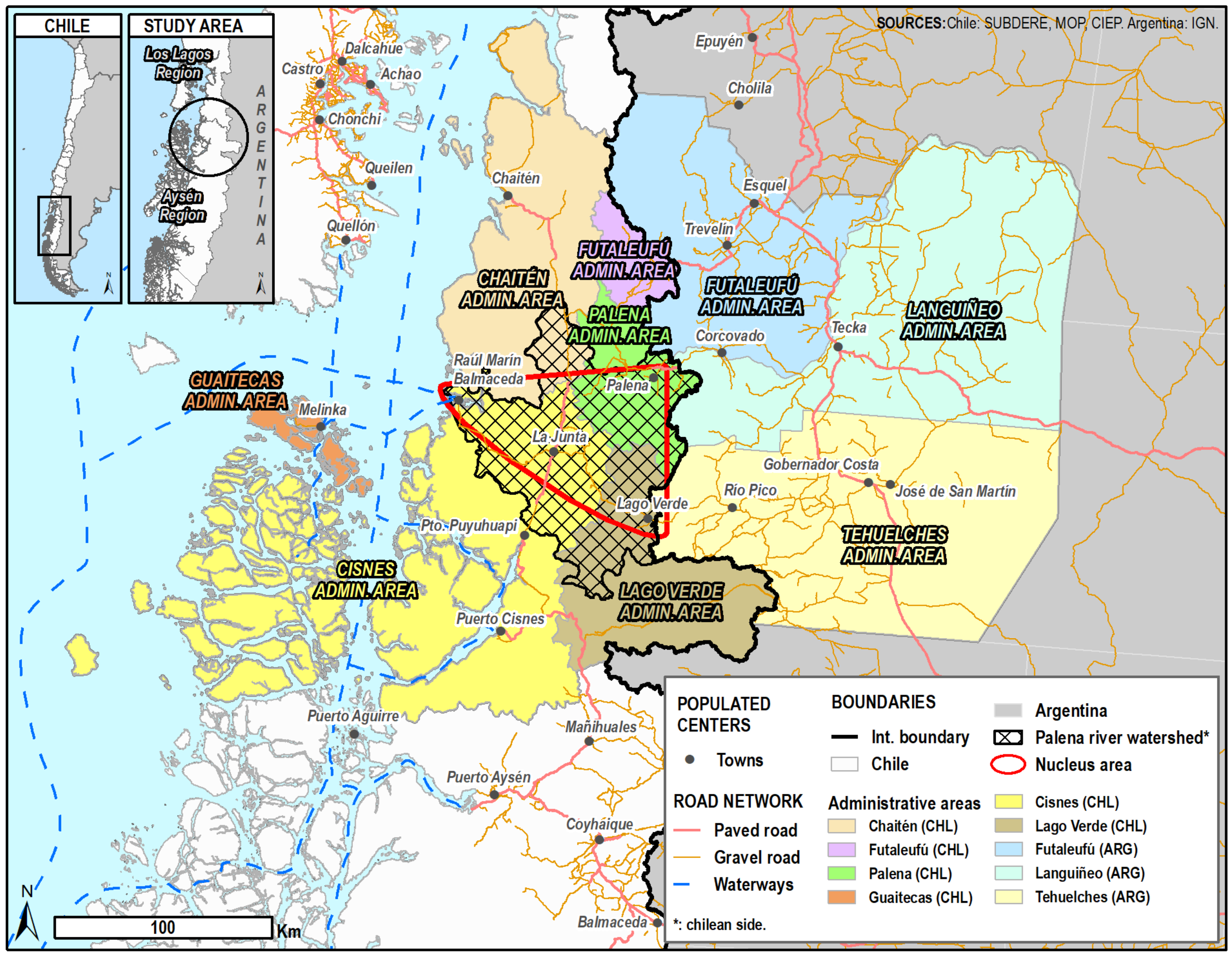
3.1. Study Area and Context

This research was part of a larger initiative referred to as, Scientific Tourism in the Palena River Watershed, Aysén Region of Chile, which had the objective of supporting socio-cultural, scientific, and tourism development within an isolated and emerging part of north-western Patagonia (Figure 2). The project sought to develop the foundation from which the communities of the watershed could build and evolve as an emergent ST destination. The study area (42°11′–45°6′ S latitude; 69°30′–75°12′ W longitude) was in the Aysén region of Chile, and the Argentine Chubut province, both approximately 1400 km of their respective national capitals, south of Santiago, and southwest of Buenos Aires. The area was framed by the municipal administrative boundaries that bordered the Chilean portion of the Palena River watershed: specifically, the Chilean administrative areas of Lago Verde, Cisnes, Guaitecas, Chaitén, Futaleufú, and Palena, and the Argentinean administrative areas of Tehuelches, Languiñeo, and Futaleufú (Figure 2).
In total, the Palena river watershed area encompassed some 13,396 square kilometers, including continental areas of Argentina (45%), and Chile (55%), which extended to Chilean coastal areas of the Pacific Ocean [22]. This area represented one of the least populated zones within Chile, with population densities ranging from 0.19 habitants per square kilometer in the Lago Verde area, to 0.36 habitants per square kilometer in the Río Cisnes area [22]. The Scientific Tourism in the Palena River Watershed project focused on a nucleus area involving four small Chilean villages: Palena (population 1045), Lago Verde (population 274), La Junta (population 1431), and Raúl Marín Balmaceda (population 239) [23].
Livelihoods within the Palena River watershed have historically been linked to cattle ranching, artisanal fishing, aquaculture, forestry, and mining; all of which represent activities that have been in crisis or decline during the last two decades [24]. In this context, tourism has emerged as an alternative livelihood option, with the potential to provide a mechanism for families to maintain rural homes and lifestyles [25]. Nature-based tourism emerged in the Aysén region in the 1990s and has demonstrated steady single-digit growth over the past three decades, reaching 193,000 visitors in 2000: 319,000 in 2008, and 566,000 in 2016 [26]. According to the 2017 Aysén Region Tourism Industry Analysis Report [26], tourism revenues in the region surpassed $USD54.6 million in 2010, and daily tourist spending averaged around $USD55, during the period spanning 1998–2014. The region has three main sub-destinations: the Carretera Austral (CA) North (which largely coincides with the study area), Aysén-Coyhaique, and the CA South. Although approximately 23% of the region’s travelers enter for the border crossings located in the Carretera Austral North sub-destination, in 2015, the three Chilean administrative areas of Lago Verde, Cisnes, and Guaitecas, which correspond to the study area and the Aysén region represented just 9.8% of formalized tourism-related businesses [26]. Natural attractions in the area include several Chilean National Parks and Reserves, including Lago Rosselot National Reserve, Queulat National Park, and the multiple-use Pitipalena-Añihue Marine Protected Area (MU-MPA). Most of the tourism movement within the study area has traditionally been related to travelers who are touring the length of the CA, a scenic highway that spans 1240 km, passing through the entire Aysén Region from north to south. While some small private lodges offer high-end all-inclusive packages, most of the tourism business caters to travelers touring the CA and remain focused on rural lifestyles and activities offered by micro-entrepreneurs in fly fishing, horseback rides, boating and kayaking, and trekking, within protected areas or ranches on family farms. Towns that are closer to the CA, like La Junta, receive the bulk of travelers, while those further off the main route, like Raúl Marín Balmaceda and Lago Verde, receive much less visitation.
Scientific research in this region has been carried out since the period of exploration to define the territorial boundaries between Chile and Argentina between 1896 and 1902. Remoteness, isolation, sparse population, extreme climate, difficult access, and limited infrastructure presented serious barriers for scientific study during much of the 20th century, concentrating scientific study around natural resources and fishing along the coast [27,28]. The number of research projects in the area increased substantially in the 1990s, with construction of the CA and the installation of public-private laboratories (INIA, INFOR, IFOP), public-service technical research units (SERNAGEOMIN) and satellite campuses of some Chilean national universities (Universidad Los Lagos, Universidad Austral de Chile, Universidad de Concepción, among others). Another milestone for science in the region occurred in 2005, with the creation of a regional research institution, the Centro de Investigación en Ecosistemas de la Patagonia (CIEP), funded by the Chilean National Science Commission (CONICYT) [29]. Since that time, scientific research has increased significantly in the study area, but has remained dominated by researchers from outside the region and focused on the global understanding of ecosystems, with minimal direct links to local communities [30]. During the past decade, the region has established a regional university (Universidad de Aysén) and a regional museum, which continue to build local science and technology capacity. Scientific research within the study area has focused on a variety of discipline areas, including history, culture and archaeology, oceanography and aquaculture, agricultural and forestry activities, social geography and tourism, geology, volcanism, among others [29].

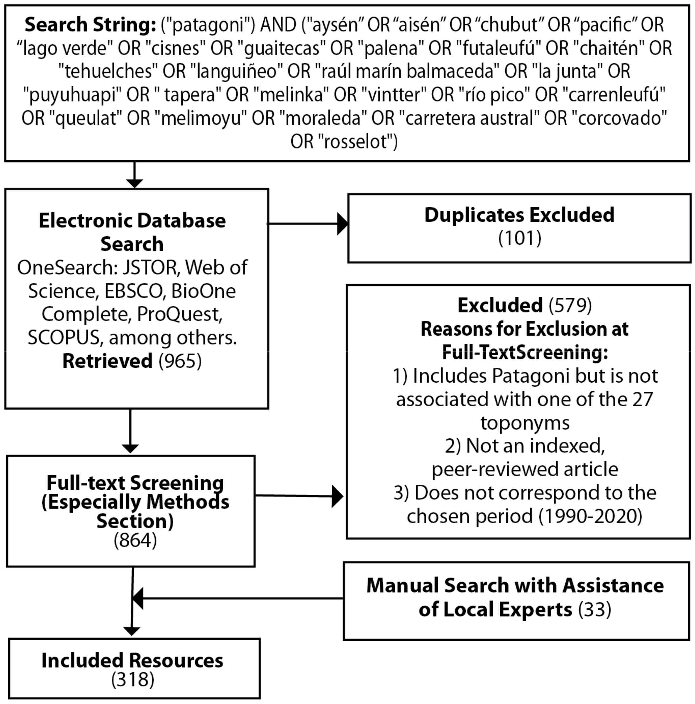
3.2. Search Strategy

To identify potentially relevant articles, this study adapted search methods used by Borrie et al. [31] to identify literature that would appropriately address the research questions. Using the OneSearch platform, which includes a wide range of more than 450 electronic academic databases. The search strategy employed a selection of geographic toponyms, or place names, present in the study area to identify published scientific research that was associated with the places within or around the area of interest. Toponyms are the names of places within a certain geographical region and represent the ways in which local inhabitants interpret their living environment at the time of naming [32]. Place names represent an important source of information for geographic analysis, since when inserted in a place, they contain information about a specific physical and social context [33]. In addition, their systematization is a tool for integration with other types of information [34]. A relationship between tourism and the names of particular places has also been identified, as many place names (e.g., Patagonia) are attractors for tourists, and as such, are exploited by operators and tourism marketing agencies [35].
Scientific articles usually include indications of their area of study in their title, abstract, keywords, and/or methods sections. Therefore, when selecting toponyms for the search in online libraries, work was carried out based on the consultation of various documentary sources in the area (topographic maps, tourist maps, road maps, territorial planning documents). This resulted in a preliminary list of general and local toponyms that included names of administrative areas, populated centers, and geographic landmarks (rivers, lakes, valleys, gulfs, fiords, hills, volcanoes), related to the study area. The initial list was subjected to a series of pilot searches within the database to establish a comprehensive, yet manageable number of relevant results. This process of consolidation employed member checking and consensus building among the members of the research team, who possessed expert knowledge of the science and geography of the region. Additional to the generic name Patagonia, the final list of relevant names of places contained three regional toponyms (Aysén OR Aisén, Chubut, Pacific); and 24 local toponyms (Carrenleufú, Carretera Austral, Chaitén, Corcovado, Futaleufú, Guaitecas, La Junta, Lago Verde, Languiñeo, Melimoyu, Melinka, Moraleda, Palena, Pitipalena, Puerto Cisnes, Puyuhuapi, Queulat, Raúl Marín Balmaceda, Río Cisnes, Río Pico, Rosselot, Tapera, Tehuelches, and Vintter). The resulting search string is available in Figure 3.
Accordingly, the search criteria required one or more of the prioritized toponyms to be present within the title, abstract, or keywords. Additional criteria for the search included the requirement that results were published within peer-reviewed journals between 1990 and 2020.

3.3. Study Selection

Study selection began with the identification of 965 publications in the OneSearch search engine according to the reported toponym text string. After 101 duplicate articles were removed, full-text screening took place for the 864 articles, with an emphasis on the methods section, as most articles include a subsection describing their area of study. A total of 579 articles were excluded during this phase, as they did not meet the required conditions of including “patagoni” AND another of the 27 toponyms, OR they were not a peer-reviewed article, OR they were not published during the specified timeframe, between 1990 and 2020. After this step, the database was reviewed by 17 local scientists working at regional universities and research centers, with the invitation to add relevant peer-reviewed resources that met the search criteria, with respect to toponyms and years of publication. A total of 17 local experts participated, representing the disciplinary fields of social science, geography, archaeology, anthropology, history, geophysics, oceanography, hydrology, biology, mycology, and forest ecology. They recommended an additional 24 articles and nine peer-reviewed books, which were added to the database, for a total of 318 resources, selected for inclusion within the study.

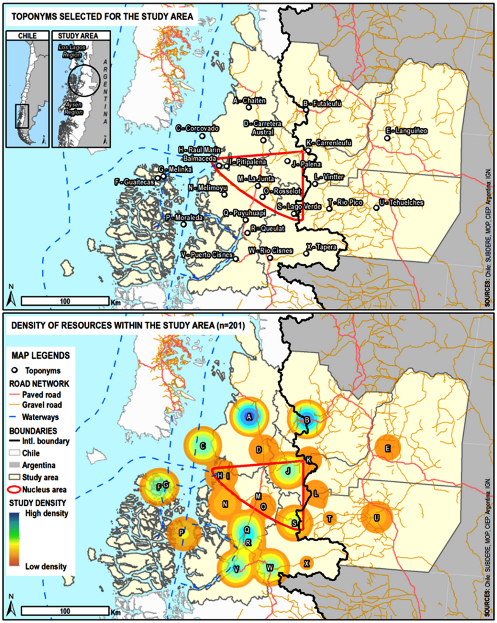
3.4. Geographic Component

The structured (or systematized) literature review was enriched with a geographic component. Building on the tradition of constructing and communicating tourism destinations through representations of cultural and natural heritage through thematic maps [36,37,38,39,40], we sought to associate the articles that were reviewed with a specific geographic reference within the study area, facilitating the cartographic visualization of the areas of study that they involved. We maintained an approach consistent with the broad survey nature of the structured review and our specific research questions, employing a similar logic to many processes of Public Participation Geographic Information Systems (PPGIS). Thus, we sought to identify overarching patterns of concentration and emphasis (hotspots) and areas with lesser coverage within the results, rather than obtain a high degree of precision for the localization of the documents. Similarly, PPGIS processes often rely on the collection of geographic data through non-experts, whose inputs may lack exact precision, but are useful for a multitude of applications, such as urban planning, environmental management, indigenous land delimitation, or mapping traditional ecological knowledge [41].
As a systematic review of all existent scientific literature was not required, and the benefits of a faster, more manageable approach far outweighed those of an exhaustive one, the choice to employ a structured literature review was made. The general philosophy of the work was to locate a representative universe of academic production and mapping of general scientific knowledge being produced within the territory. The results of this study required approachable, easily interpreted tools that could facilitate dialogue with the local community and scientists; thus, maps provided relevant graphic scientific resources to inform and foster ST product development for the sustainable development of the territory. Some publications contained several toponyms; only one was chosen for mapping based on its ability to associate the article with a specific location. For example, if “La Tapera” (a village within the study area), “Cisnes” (a commune within the study area), and “Aysén” (the region), were all detected within an article, “La Tapera”, was chosen as the most precise and specific location within the study area.

3.5. Analysis

This structured (or systematized) literature review employed two levels of analysis. First, studies were categorized according to six areas of scientific knowledge prioritized within the Knowledge for Scientific Tourism Taxonomy (Figure 4), agreed upon for use within the project: 1. History and culture (collective), 2. Education, health, and personal development (the individual), 3. Territory planning, management, and development, 4. Flora, fauna, ecosystems, and population dynamics, 5. Earth and ocean dynamics; and 6. Universal and conceptual sciences [5]. Next, the publication keywords were used to associate each article with one of the scientific sub-disciplines within the standard UNESCO “Areas of study and training of the International Standard Classification for Education” [42]. In the case of multidisciplinary publications, the most general sub-discipline was chosen (e.g., geography, ecology, etc.). Lastly, each study was geographically referenced through their association with one of the 27 toponymic areas, or sectors.

4. Results

4.1. RQ1: How Are the Bibliographic Resources Geographically Concentrated within and around the Study Area?

Of the total 318 resources within the sample, 201 were directly attributed to the study area. Thirty-one resources were within the project nucleus toponymic areas of La Junta, Lago Verde, Palena, Pitipalena, Raúl Marín Balmaceda, and Rosselot. An additional 170 resources were dispersed within the 18 additional toponymic areas of study area (Figure 5). Toward the western part of the nucleus area, the Pitipalena and Raúl Marín Balmaceda toponymic areas had one and three resources, respectively. Some of the biggest concentrations of resources occurred around the project nucleus area: along the coast, in toponymic areas like Guaitecas (n = 13) and Corcovado (n = 16); to the north in toponymic areas like Chaitén (n = 30), and Futaleufú (n = 26); and to the south in toponymic areas including Puyuhuapi (n = 15), Puerto Cisnes (n = 17), and Río Cisnes (n = 15). In the peripheral zone of the study area, another 117 resources were identified, which might also nourish a scientific tourism offer for the localities under study. These resources were geo-referenced to three generic points: Aysén (n = 59), Chubut (n = 38), and Pacific coast (n = 20).

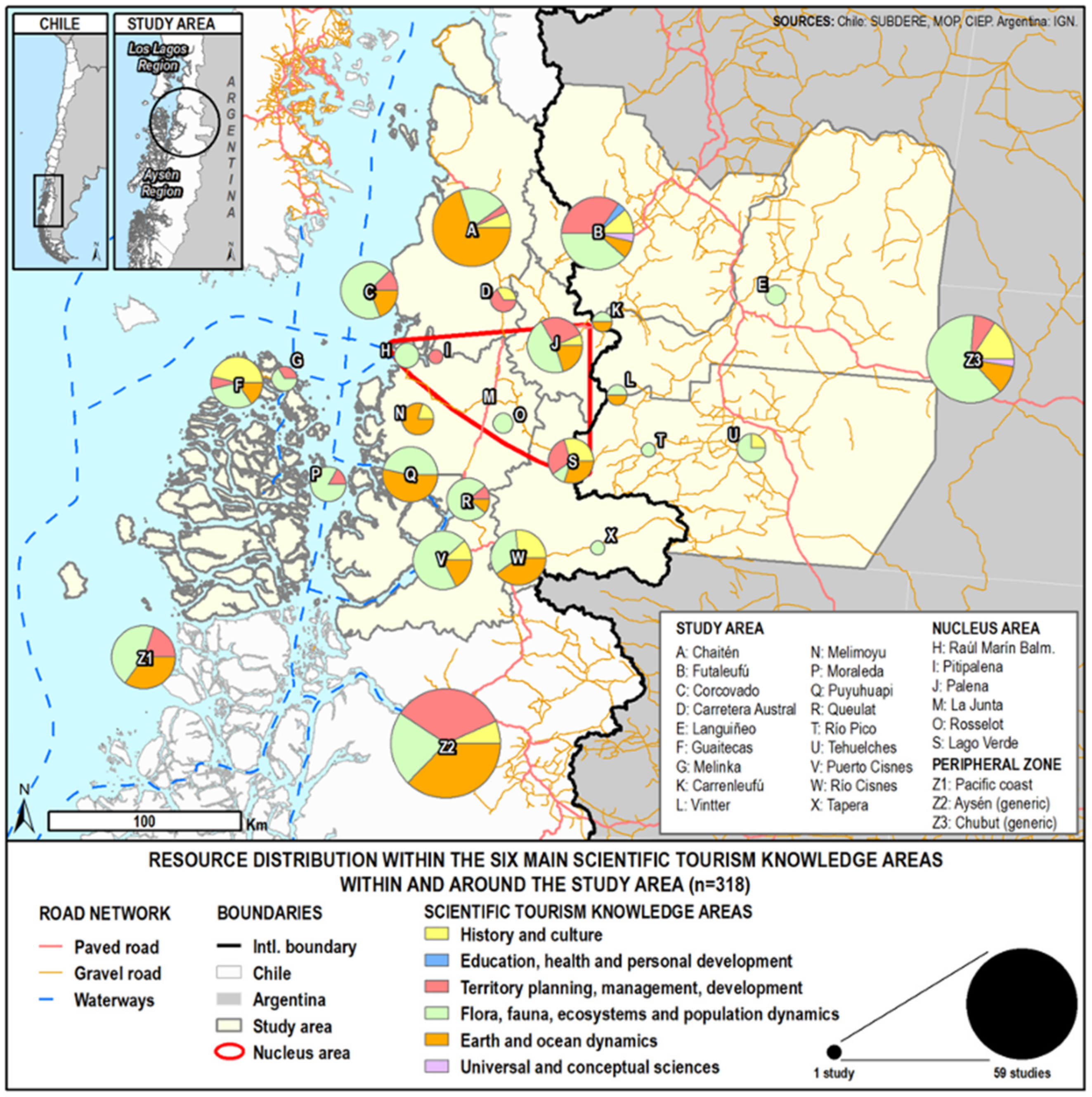
4.2. RQ2: How Are the Bibliographic Resources Distributed according to the Six Main ST Knowledge Areas, within and around the Study Area?

Figure 6 shows the distribution of resources within the six scientific tourism knowledge areas in and around the study area (n = 318), according to the structured literature review. The Flora, Fauna, Ecosystems, and Population Dynamics TS knowledge area represented the topics for the largest number of articles (n = 137), which were dispersed within all the toponymic areas, except Pitipalena and Carretera Austral. Ninety-one resources were related to the Earth and Ocean Dynamics TS knowledge area, with prominent presence in Chaitén (n = 21), Puyuhuapi (n = 8), and Melimoyu (n = 4). Education, Health and Personal Development and Universal and Conceptual Sciences were the ST knowledge areas with the lowest presence of resources in the study, with one and two publications, respectively. Within the resources attributed to the project nucleus area, a total of four TS knowledge areas were represented: History and Culture (n = 4); Territory Planning, Management, and Development (n = 8); Flora, Fauna, Ecosystems and Population Dynamics (n = 13); and Earth and Ocean Dynamics (n = 6). Three of the nucleus toponymic areas, Pitipalena, Raúl Marín Balmaceda, and Rosselot only had studies within one ST knowledge area, while Lago Verde and Palena had studies within four ST knowledge areas, with equal distribution of resources for social and natural sciences. Knowledge area diversity increased for the toponymic areas; both within the 18 other toponymic areas of the study area, which averaged between two and three ST knowledge areas, and for the three generic toponymic areas in the periphery of the study area (Aysén, Chubut, Pacific coast), with resources that were dispersed within an average of four ST knowledge areas.

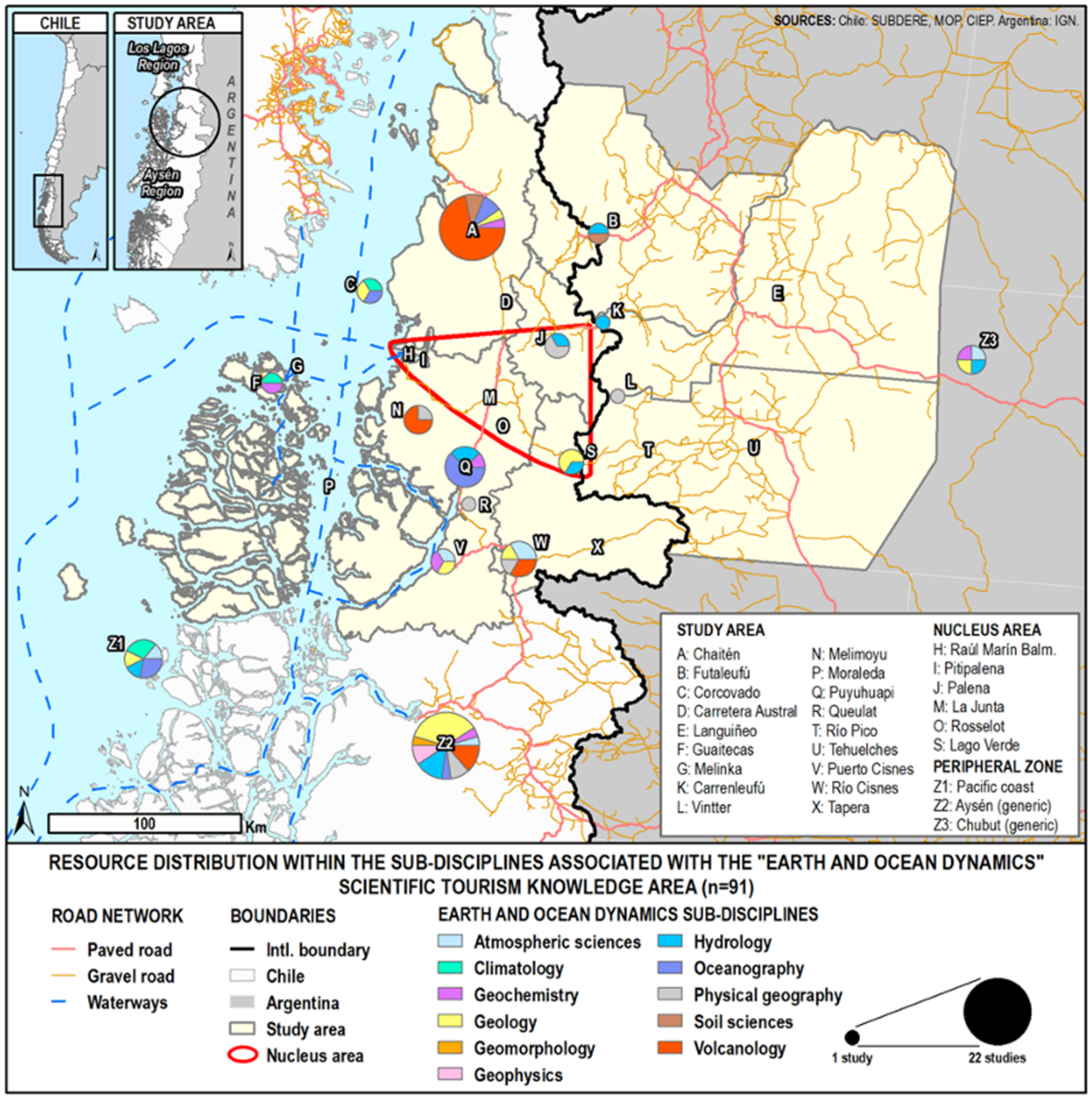
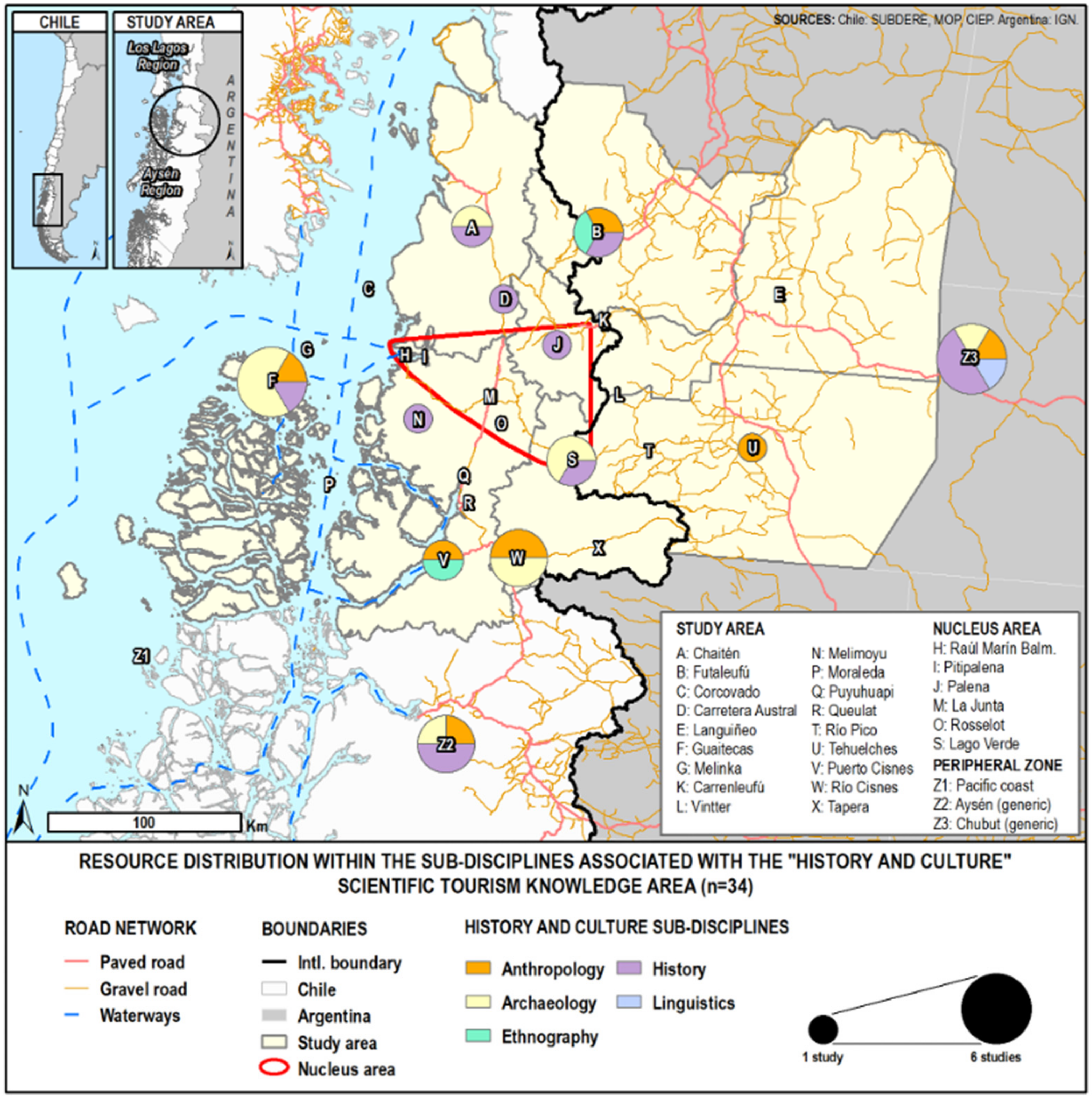
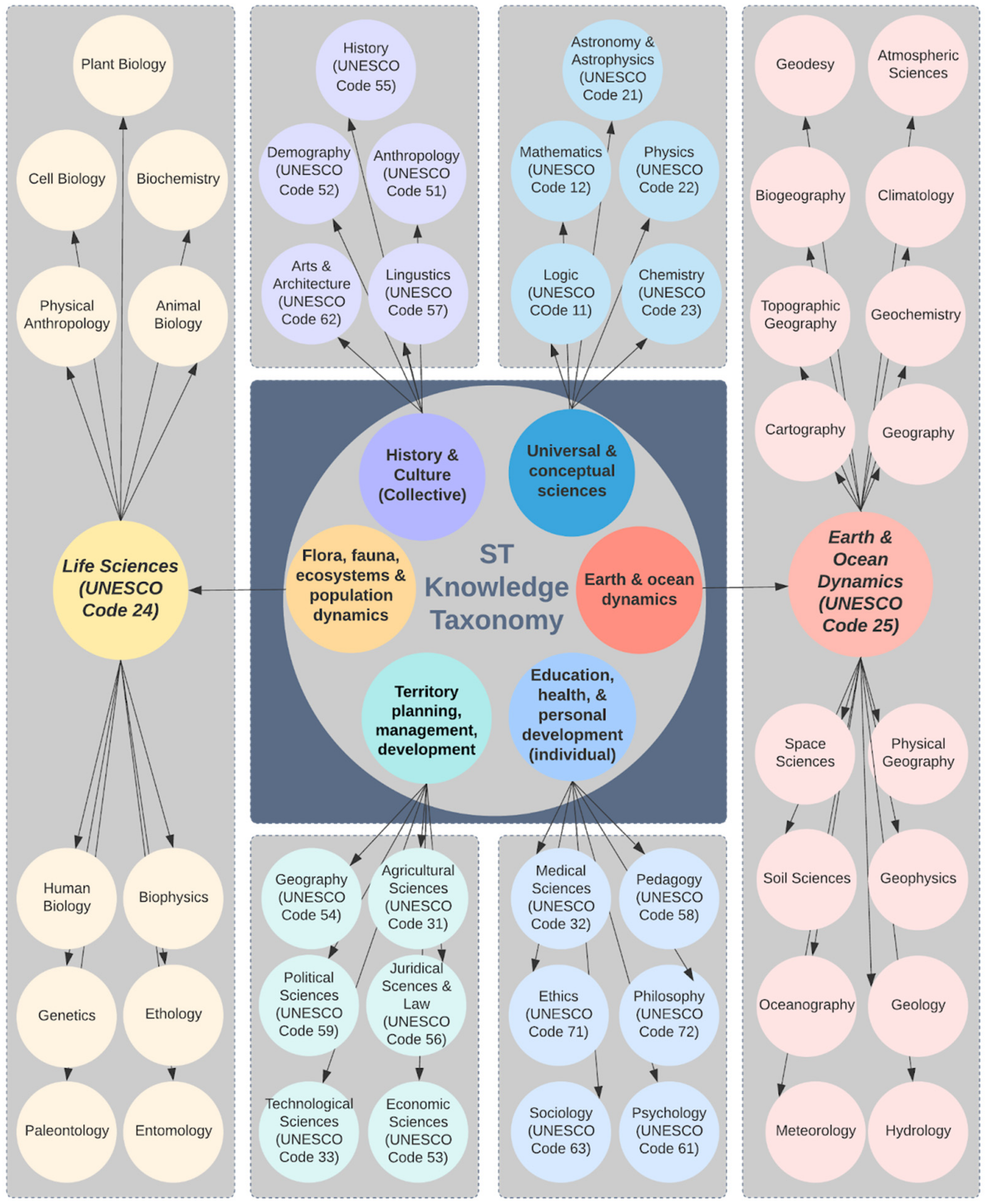
4.3. RQ3: How Are the Bibliographic Resources within and around the Study Area Distributed within Scientific Sub-Disciplines, across the Six Main ST Knowledge Areas?

The 318 resources were distributed within 12 of the 23 UNESCO scientific sub-disciplines [42] and within some, they were attributed to more particular sub-discipline topics (Table 1). For example, within the UNESCO Life Sciences sub-discipline (n = 137), studies pertained to eight specific topics: Plant biology, n = 12; Cell Biology, n = 7; Animal biology, n = 27; Ethology, n = 10; Genetics, n = 43; Entomology, n = 5; Palaeontology, n = 10; Ecology, n = 23. Several the UNESCO sub-disciplines were not represented within the resources, including demography, sciences of arts and letters, juridical sciences and law, logic, mathematics, astronomy and astrophysics, and physics.
Within the ST project, specialized maps were developed to support each of the six ST knowledge areas. Figure 7 and Figure 8 provide two examples of these maps, which proved to be especially relevant for understanding how the bibliographic resources within and around the study area were distributed across scientific sub-disciplines and the six main ST knowledge areas. Figure 7 shows the geographic distribution of studies for the topics within the UNESCO sub-discipline Earth and Space Sciences (UNESCO code 25), which corresponds to the Earth and Ocean Dynamics ST thematic area (n = 91). The map helps illustrate several tendencies that surfaced within the data, with respect to potential TS product themes for the study area. For example, three toponymic areas (Chaitén, Melimoyu, and Río Cisnes), had a concentration of resources related to “Volcanology,” and two others (Puyuhuapi and Corcovado), had a concentration of resources related to “Oceanography.” Within the project nucleus, studies relating to this sub-discipline were concentrated within the Lago Verde and Palena toponymic areas; each had three resources representing topics related to “Geology,” “Hydrology,” and “Physical Geography.” The three generic toponymic areas in the peripheral zone of the study area provided resources that might support these two foci. For example, both the Chaitén and Aysén generic toponyms could provide greater depth and insight with regards to “Volcanology” and with the addition of the Pacific coast toponym, all three provide additional resources, supporting the potential for TS products focused on “Oceanography.”
Figure 8 provides a second example of UNESCO sub-disciplines and topics associated with the articles within the History and Culture TS knowledge area (n = 34). While “History” manifested most strongly within this TS knowledge area (UNESCO code 55; n = 22), its distribution within the project nucleus was limited to Lago Verde and Palena. Within Lago Verde, this sub-discipline included studies on history and archaeology; while in Palena, only history-related studies emerged. Archaeology research was also identified within the Guaitecas and Río Cisnes toponymic areas, as well as within the three generic periphery toponyms.

5. Discussion

The results of this study help to inform the initial stage of the ST product development process (see Figure 1) through the identification of scientific heritage resources that can be brought into the ST product development process within a specific geographical area. Typically, the geo-bibliographic information is made available to project facilitators, collaborating scientists, and local community actors in a database format, and graphic representations are provided through distribution maps, similar to those within the results section above (Figure 5, Figure 6, Figure 7 and Figure 8). These tools provide the project team with basic knowledge about where and how science has taken place in their territory that helps them identify and evaluate potential resources and opportunities for ST projects. The following sections discuss how the tendencies related to research density, research topics, and geo-localization, have supported the potential for ST development within the Palena River watershed, and specific opportunities that have been identified through the research results.

5.1. Geographic Representation of the Scientific Publications within and around the Study Area

A total of 31 bibliographic resources included in this study (10% of the 318 total), pertained to the six toponymic areas (Lago Verde, La Junta, Palena, Pitipalena, Rosselot, and Raúl Marín Balmaceda), that were directly associated with the nucleus area of the Palena River watershed ST project. Most of these resources focused on Palena (n = 15) and Lago Verde (n = 10), with a few others focusing on the coastal areas of Raúl Marín Balmaceda (n = 3), and Pitipalena (n = 1). While there were no resources attributed with La Junta, there were two associated with Rosselot (12.5%), the nearby location for the Lago Rosselot National Reserve, and two of the resources for Palena also mentioned La Junta. Surfacing these studies within the nucleus of the project zone provides initial orientation about the potential for ST products and routes. Most of the toponymic areas within the nucleus are connected by a 144 km east-west route, extending from the Argentine border to the Pacific, or by water routes following the main rivers within the watershed. Thus, from a geographic perspective, it appears feasible to develop local ST projects or routes connecting existing research areas along this axis.
Zooming out from the project nucleus to consider the 18 toponymic areas identified within the rest of the study area, 170 additional resources were retrieved. The resource density map (Figure 5) shows the geographic distribution of these studies among the toponymic areas, suggesting two scientific clusters where there were heavier concentrations of resources. First, to the north of the nucleus, a cluster emerged within the adjacent toponymic areas of Chaitén (n = 30), Futaleufú (n = 26), and Corcovado (n = 16). Together, these toponymic areas were the study sites for more than 20% of the total resources that emerged within the study, suggesting that they represent an important area for relevant research and ST themes. A second cluster emerged to the south of the project nucleus, within the toponymic areas of Puyuhuapi (n = 15) Queulat (n = 9), Río Cisnes (n = 15), and Puerto Cisnes (n = 17), which together, represented just under 18% of the resources within the study. Guaitecas (n = 13) represents another important toponymic area and its strategic proximity to the nucleus area facilitates maritime product development. Understanding these areas of concentration can help inform stakeholders within the nucleus about potential zones with which they could align. As well, considering the proximity and characteristics of these clusters, might help them identify potential scientific areas of study that could also be relevant within their communities. The remaining 37% of the resources pertained to research conducted along the periphery of the nucleus project zone, and are also important to consider, as they might have transferability to sites within the nucleus or help to inform stakeholders of possible collaborations.

5.2. Bibliographic Resource Distribution according to ST Knowledge Areas, within and around the Study Area

Understanding the topics and concentrations for science taking place within the geography is important for ST product and destination development as it helps to align research information with potential product themes, community, and visitor interests. The present study identified two core thematic areas for science taking place within and around the area of the project. A total of 91 resources within the nucleus and study area, and 46 additional resources within the peripheral area, were related to research about Flora, Fauna, Ecosystems, and Populations Dynamics, representing slightly more than 43% of all identified publications. The next highest concentration of resources, representing close to 29% of the study sample, pertained to the Earth and Ocean Dynamics TS knowledge area, which was associated with 58 of the publications that occurred within the nucleus, and area of study, and another 33 that occurred within the peripheral area. These tendencies bode well for TS potential within the project, providing thematic areas of strength in areas that align with the abundance of natural resources, landscapes, and protected areas, prevalent throughout the zone.
Further analysis of the Earth and Ocean Dynamics-related publications identified predominant topics as being Geology and Volcanology (n = 39) followed by Oceanography (n = 11), Hydrology (n = 11), Atmospheric Sciences and Climatology (n = 10), and Physical Geography (n = 8). Volcanology appeared within several of the toponymic areas surrounding the nucleus zone for the project; yet the six Earth and Ocean Dynamics-related publications within the nucleus were related to Geology, Hydrology, and Physical Geography. Further exploration and research might draw linkages between these areas of study, focusing on their connections and interrelations, through new, collaborative research that offers visitors and communities opportunities to participate.
There were also 87 studies that related to social science themes, including Territory Planning, Management, and Development (n = 53), and History and Culture (n = 34). This relative concentration of these social science-related studies suggests the potential for product development to evolve along multiple and varied themes. Finer analysis within these social ST thematic categories identified History, Anthropology, and Archaeology as the most prevalent topics which align well with ST and community interests.

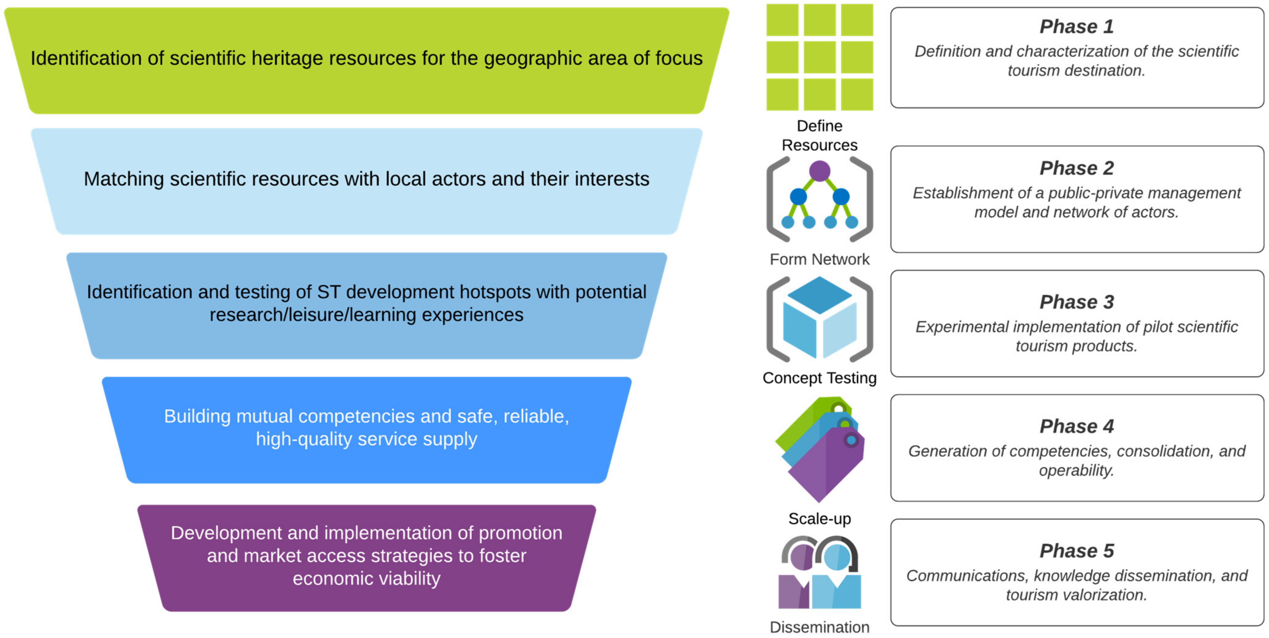
5.3. Integrating Scientific Knowledge and Scientific Tourism through Pilot Initiatives

Both François et al.’s [12] description of territorial discovery and justification phases of patrimonialization, and Nunes and Sousa’s [13] emphasis on reaching territorial coherence in order to achieve perfect TS resources, support the importance of working with local actors to collaboratively understand and evaluate potential scientific resources for TS, and related sustainable tourism objectives that focus on conserving territorial heritage [43]. Within the Palena River watershed project, TS phase one results (developed through the empirical research presented in this paper), were used to inform these processes (Figure 1). Using a series of forums and a participatory process that matched resources with local actors and their interests, the research results and maps were presented, debated, and discussed, as the actor network moved through the discovery, justification, and territory coherence building processes [1,12,13]. The actor network included scientists who lived or worked in the area and were interested in TS collaboration, entrepreneurs in tourism and related sectors, and organizations that managed tourism resources and scientific information. Actors applied and debated the results of phase one to determine four primary areas of initial focus for the Palena River watershed TS Project: Geology, Life Sciences, Social Geography, and History-Archaeology. They based their decisions on their determination that relevant scientific resources existed, and scientific processes could be implemented, permitting an exhibition, through ST activities, that would improve the knowledge base and resilience of related natural and cultural heritage [12].
Participants in this process found the database and maps of existing scientific resources to be relevant tools that helped them to establish strategies to enhance local heritage and implement ST initiatives. Nevertheless, they expressed the need for more qualitative and descriptive reports of existing scientific knowledge related to relevant heritage landmarks to assist communication, awareness, interpretation, and education around the socio-environmental particularities of the study area, to strengthen socio-cultural and tourism development. The maps developed within the study also served the Palena River watershed actors’ network as they moved through the third TS stage, focusing on the identification of hotspots (emblematic sites and themes) for ST development, which linked scientific research with TS activities, through pilot initiatives. Pilot ST initiatives were debated within the actors’ network and eight pilot initiatives were identified that met scientific, community, and ST entrepreneurial interests, aligning with past, ongoing, or needed research. These included:
  • Pilot 1 (P1): The active volcanism of Palena and Aysén. Focusing on the Earth and Ocean Dynamics TS thematic area, this ST pilot initiative will highlight geosites to educate the importance of active volcanic phenomena in the Palena watershed, specifically focusing on the Barros Arana Mountain range or the eastern sector of the Queulat National Park. Local guides will support upcoming scientific missions to learn hands-on skills that can support the development of routes and programs that will provide visitors with a “behind the scenes” experience that combines hiking, river sports, and scientific learning.
  • TS Pilot 2 (P2): Human-environment interactions within the ecosystems of Lago Verde. This pilot will focus on Flora, Fauna, Ecosystems, and Population Dynamics TS thematic area, through the development of transdisciplinary socio-ecological scientific research experiences in which the community will work with visitors, residents, and scientists, to document and better understand how human actions affect the different ecosystems surrounding the Lago Verde toponymic area.
  • TS Pilot 3 (P3): Mitigating climate change through local regenerative agriculture. This pilot initiative will focus on the farms and practices undertaken within the local permaculture experience that has been developed in La Junta by the Ruta del Jardín Austral [Southern Garden Route] network. Research will work from the perspective of the Territory Planning, Management, and Development TS knowledge area, collaborating with regional agriculture extension specialists to document regeneration processes of degraded soils and vegetative adaptation mechanisms to the effects of climate change, and the potential for replication in other areas. Tourism product development will participate in research, volunteer within the farms, and participate in courses and workshops that combine local practices and scientific insights.
  • TS Pilot 4 (P4): Mycology of Palena. This pilot is focused on the Flora, Fauna, Ecosystems, and Population Dynamics TS knowledge area and will align with ongoing regional mycology research, establishing instances and formats for knowledge transmission. Local communities and visitors will be invited to assist participatory research taking place in La Junta and unstudied areas of the communes of Lago Verde (Lago Verde sector) and Cisnes (Río Cisnes sector). Knowledge transfer will focus on developing tourism products that use a magnifying glass to explore the mycology at a micro level within local sites.
  • TS Pilot 5 (P5): The honey of Cisnes. This pilot is focused on the Territory Planning, Management, and Development TS knowledge and will develop transdisciplinary research to support beekeeping and honey production processes in the study area. Initial research will focus on understanding queen reproduction and natural management of bee diseases in Aysén. Guided visits will be made to beekeeping operations in the Cisnes commune, educating visitors on the benefits, best practices, and study results.
  • TS Pilot 6 (P6): Conservation monitoring within the Pitipalena-Añihue multiple use marine protected area (MU-MPA). This pilot will focus on supporting biodiversity monitoring within the Pitipalena-Añihue MU-MPA, aligning with the Flora, Fauna, Ecosystems and Population Dynamics TS knowledge area. Tourists will have the opportunity to accompany scientific nautical excursions, participating in sampling, photographic documentation, and related actions designed to strengthen monitoring within the MPA through enhanced citizen surveillance.
  • TS Pilot 7 (P7): Natural and cultural heritage of the Palena Route. This pilot project aligns with the History and Culture ST knowledge area, continuing historical and cultural surveys within the nucleus area of the project, through involvement of the community and specialized ST visitors. In addition to more technical ST products that will be oriented to tourists with an appropriate scientific profile for this type of research, a series of scientific hikes guided by specialists will be oriented for other ST visitor profiles, using experiential (learning by doing) approaches to enhance the value and knowledge of historical colonization routes that began in the Raúl Marín Balmaceda toponymic area and progressed eastward along the Palena River.
  • TS Pilot 8 (P8): Following the legacy of ancestral cultures. Positioned within the History and Culture ST knowledge area, this pilot initiative will involve archaeological and historical exploration along the Pacific coast between Puerto Cisnes and Raúl Marín Balmaceda to photographically inventory-relevant archaeological sites. Through navigations coordinated with scientists and guided by specialists, this pilot seeks to highlight tangible heritage (areas, geosites, natural landmarks) and intangible heritage (historical sites or sites of relevance for ancestral stories and cosmovision).
Future project actions will focus on the fourth phase of the TS process, through the collaborative development of these pilots, which should allow the network to build mutual competencies, validate their assumptions, and consolidate service supply through the production of materials to support scientific dissemination and participatory science. Lastly, the fifth stage will involve development and implementation of strategies for communication, promotion, and market access to foster economic viability [1,5]. Future research is suggested to accompany these later steps in the TS process, evaluating the viability and sustainability of the pilots and further validating the effectiveness of the information gained through the current research.
Six of the TS pilots that evolved during the project (P1, P2, P4, P6, P7, and P8) were directly influenced by research that surfaced during the study presented within this paper. Research results helped to identify past initiatives, research clusters, and relevant scientists, who had or are working in the associated ST knowledge areas within the toponymic areas. New alliances between scientists and local stakeholders or guides that can become assistants in field research create innovative dynamics relevant for tourism by creating new capacities and innovative initiatives that bridge science, education, and recreation. The economic value of each of these pilot initiatives are yet to be studied, some will show more social (science dissemination) than economic impacts (new commercial products). Here, the structured, or systematized, literature review methodology proved to be very beneficial for ST product development, by helping to highlight research trends that were later expanded during subsequent phases of the project.
The other two ST pilots, (P3, Mitigating climate change through local regenerative agriculture; P5, Cisnes honey, represented strong local interests), were not directly influenced by the articles that surfaced during the research. Rather, they evolved because of local territorial dynamics and stakeholder interests. Our research did not identify existing studies that supported or informed these two initiatives, although, as suggested, there are relevant research needs and opportunities for transdisciplinary TS innovations. Perhaps supporting science exists for these areas and simply did not surface in the research process of this study. Or perhaps this suggests that the TS process may be capable of facilitating two-way scientific dialogue. First, it may help to connect past and present research taking place in a territory with local communities, stakeholders, and visitors. Second, it might help to surface community needs and development opportunities that can inform territorial Science, Technology, and Innovation priorities and policies.

5.4. Limitations

The OneSearch tool does not search all databases to which a university might subscribe. For example, it does not include non-web-based databases, ones that are available on CD-ROM, or those that require access from dedicated workstations. In addition, some university databases are not included in OneSearch due to publisher restrictions, such as WestLaw and HeinOnline. Nevertheless, the OneSearch tool includes a wide range of more than 450 electronic academic databases, and the authors felt comfortable that the resulting articles covered a breadth of scientific topics and toponyms within the area of study and met the study objective of maintaining a manageable scope. The current study’s focus on peer-reviewed articles and a few books that were suggested by local experts, helped to identify matches between project stakeholders and scientific research taking place for six of the eight TS pilot initiatives that emerged. Nevertheless, two of the pilots might have been better supported from a scientific point of view, through analysis of regional scientific white papers or technical studies, as the solutions-based approach typically taken in these documents would align well with Territory Planning, Management, and Development TS knowledge area challenges. Similar analysis might be applied to public databases of research projects; both awarded and applied, as this data could inform stakeholders about research that is still in development and potential collaborations with scientists and their institutions.

6. Conclusions

This article has focused on the initial stage of the ST product development process that has been used within the Aysén Region of southern Chile for the past 15 years. Grounding tourism on science has provided regional stakeholders and destinations with an alternative to more traditional forms of nature-based and rural tourism, that brings them closer to the science taking place within their geography. Geo-structured review methods have proven to be an effective tool in Aysén, providing an efficient methodology for developing an overview of the research taking place within specific areas like the Palena River watershed destination and inputs for subsequent product and destination development actions. Thus, this sort of methodology is likely transferrable to other low-density and peripheral geographies that share an interest in developing ST. For more highly developed tourism areas or destinations where research is more intense, bibliometrics methodologies and social network analysis may facilitate a similar “big picture” understanding [44,45].
As travel to peripheral and low-density destinations begins to reemerge in the wake of the COVID-19 pandemic, ST may offer destinations, visitors, and communities a viable approach to nature-based and heritage tourism development that assists sustainable tourism heritage conservation goals by facilitating active stakeholder participation in the scientific process and increasing community awareness, focus, and appreciation for important research topics in their territories. Demirović et al. [46] suggested that stronger relationships between natural resources and local communities could influence both daily activities and long-term wellbeing. The ST resource prioritization process may contribute to strengthening these relationships, through a series of stages designed to focus territories on the scientific resources and phenomena that are occurring. Study results and accompanying maps from the first ST stage provided effective inputs for subsequent product and destination development stages, informing resource discovery and justification. By bringing together researchers, entrepreneurs, and community actors around a group of scientific resources and encouraging actors to undertake purposeful dialogue, learning, and deliberation around resources, greater territorial coherence may occur [13]. In some cases, this may lead to resource patrimonialization or even the development of perfect resources [1,12,13]. As well, the pilot initiatives that emerged because of the ST process may lead to new research that builds understanding and place-based strategies to conserve and enhance local heritage. This is particularly important in the rural, peripheral, and low-density areas, where most of the ST pilots will evolve. Knickel and Renting [47] stated that rural development is necessary for the “production of high quality and region-specific products, nature conservation, and landscape management” (p. 513). An and Alarcón [16] added, “the active involvement of the community is the major operator of rural tourism” (p. 8). This paper demonstrates how the initial phase of the ST process contributes to increasing the active involvement of communities in the development of rural tourism practices grounded in science through a systematic approach for identifying scientific resources, associated with the territory. It also demonstrates how the ST product development process can contribute to sustainable practices that support resource patrimonialization and territorial coherence [1,12,13]. Aligned with these concepts, the ST process seeks to strengthen local knowledge and heritage through greater collaboration and coordination between scientists, stakeholders, and communities, creating a collaboration chain that increases focus and awareness around natural and cultural resource management, incentivizing a more resilient form of tourism development [48].

Author Contributions

Conceptualization, T.G. and F.B.; methodology, T.G., F.B. and A.A.; validation, T.G.; formal analysis, A.A. and T.G.; investigation, A.A., A.S. and V.Á.-B.; resources, Fabien Bourlon; data curation, A.S., V.Á.-B. and A.A.; writing—original draft preparation, T.G., Fabien Bourlon, and A.A.; writing—review and editing, T.G., F.B., A.A., V.Á.-B. and A.S., visualization, A.A. and T.G.; supervision, F.B. and T.G.; project administration, F.B.; funding acquisition, F.B. All authors have read and agreed to the published version of the manuscript.

Funding

This work was supported by Chile’s National Research and Development Agency (ANID) under ANID’s Regional Program R17A10002; and the CIEP R20F0002 project.

Institutional Review Board Statement

Not applicable.

Informed Consent Statement

Not applicable.

Data Availability Statement

Not applicable.

Acknowledgments

The authors would like to thank the Merrill Foundation for their support during the project with funding for stakeholder interactions and outreach.

Conflicts of Interest

The funders had no role in the design of the study; in the collection, analyses, or interpretation of data; in the writing of the manuscript, or in the decision to publish the results.

References

  1. Bourlon, F. La ciencia como recurso para el desarrollo turístico sostenible de los Archipiélagos Patagónicos. PASOS 2020, 18, 795–810. [Google Scholar] [CrossRef]
  2. Mao, P.; Bourlon, F. Le tourisme scientifique: Un essai de définition. Téoros 2011, 30, 94–104. [Google Scholar] [CrossRef] [Green Version]
  3. Mao, P.; Bourlon, F. Le Tourisme Scientifique en Patagonie Chilienne: Un Essai Géographique sur les Voyages et Explorations Scientifiques; Tourism and Society Collection; L’Harmattan: Paris, France, 2016; ISBN 978-2-343-07787-1. [Google Scholar]
  4. Mao, P.; Robinet, N.; Castro, D. Creación de un Destino de Turismo Científico: Análisis del Proyecto, Archipiélagos Patagónicos, Destino Internacional para el Turismo Científico; Center for Investigation in Ecosystems of Patagonia (CIEP); International Development Bank—Multilateral Investment Fund (BID-FOMIN): Coyhaique, Chile, 2016; pp. 1–41. [Google Scholar]
  5. International Network for Scientific Tourism. Available online: https://scientific-tourism.org/ (accessed on 12 March 2021).
  6. Slocum, S.L.; Kline, C.; Holden, A. (Eds.) Scientific Tourism: Researchers as Travellers; Routledge: London, UK; New York, NY, USA, 2015; ISBN 978-85-7811-079-6. [Google Scholar]
  7. Bourlon, F.; Torres, R. Scientific tourism, a tool for tourism development in Patagonia. HAL 2016, 2729, 1–12, HAL Id: Hal-01954694. Available online: https://hal.archives-ouvertes.fr/hal-01954694 (accessed on 20 May 2021).
  8. Pacheco, A.S.; Silva, S.; Alcorta, B.; Gubbins, S.; Guidino, C.; Sanchez-Salazar, F.; Petit, A.; Llapapasca, M.A.; Balducci, N.; Larrañaga, E.; et al. Cetacean diversity revealed from whale-watching observations in northern Peru. Aquat. Mamm. 2019, 45, 116–122. [Google Scholar] [CrossRef]
  9. Cisneros-Montemayor, A.M.; Becerril-García, E.E.; Berdeja-Zavala, O.; Ayala-Bocos, A. Shark Ecotourism in Mexico: Scientific Research, Conservation, and Contribution to a Blue Economy. Adv. Mar. Biol. 2020, 85, 71–92. [Google Scholar] [CrossRef]
  10. Centre Terre Origen y Misión de la Asociación [Origin and Misión of the Association]. Available online: https://www.centre-terre.fr/?lang=es (accessed on 12 March 2021).
  11. United Nations Secretariat Department of Economic and Social Affairs. International Recommendations for Tourism Statistics 2008; United Nations Secretariat Department of Economic and Social Affairs: New York, NY, USA, 2010; ISBN 978-92-1-161521-0. [Google Scholar]
  12. François, H.; Hirczak, M.; Colin, N.S.A. Dynamique et de des Ressources. Rev. D’économie Régionale Urbaine 2006, 5, 683–700. [Google Scholar] [CrossRef]
  13. Nunes, S.P.; Sousa, V.C. Recursos Perfeitos, Turismo e Singularidades Territoriais: Contributos Para o Desenvolvimento de Uma Linha de Turismo Científico na Golegã. Rev. Port. Estud. Reg. 2019, 50, 27–47. [Google Scholar]
  14. Sakata, H.; Prideaux, B. An alternative approach to community-based ecotourism: A bottom-up locally initiated non-monetised project in Papua New Guinea. J. Sustain. Tour. 2013, 21, 880–899. [Google Scholar] [CrossRef]
  15. Lane, B.; Kastenholz, E. Rural tourism: The evolution of practice and research approaches—Towards a new generation concept? J. Sustain. Tour. 2015, 23, 1133–1156. [Google Scholar] [CrossRef]
  16. An, W.; Alarcón, S. How can rural tourism be sustainable? A systematic review. Sustainability 2020, 12, 7758. [Google Scholar] [CrossRef]
  17. Grant, M.J.; Booth, A. A typology of reviews: An analysis of 14 review types and associated methodologies. Health Inf. Libr. J. 2009, 26, 91–108. [Google Scholar] [CrossRef]
  18. Huelin, R.; Iheanacho, I.; Payne, K.; Sandman, K. What’s in a name? Systematic and non-systematic literature reviews and why the distinction matters. Evid. Forum 2015, 34–37. Available online: https://www.evidera.com/wp-content/uploads/2015/06/Whats-in-a-Name-Systematic-and-Non-Systematic-Literature-Reviews-and-Why-the-Distinction-Matters.pdf (accessed on 20 May 2021).
  19. Shah, S.G.S.; Robinson, I. User involvement in healthcare technology development and assessment: Structured literature review. Int. J. Health Care Qual. Assur. 2006, 19, 498–513. [Google Scholar] [CrossRef] [Green Version]
  20. Shashi, S.; Cerchione, R.; Singh, R.; Centobelli, P.; Shabani, A. Food cold chain management: From a structured literature review to a conceptual framework and research agenda. Int. J. Logist. Manag. 2018, 29, 792–821. [Google Scholar] [CrossRef]
  21. McGrath, T.A.; Alabousi, M.; Skidmore, B.; Korevaar, D.A.; Bossuyt, P.M.M.; Moher, D.; Thombs, B.; McInnes, M.D.F. Recommendations for reporting of systematic reviews and meta-analyses of diagnostic test accuracy: A systematic review. Syst. Rev. 2017, 6, 1–16. [Google Scholar] [CrossRef] [PubMed]
  22. Chilean General Directorate of Water. Reserva del río Palena para la Conservación Ambiental y el Desarrollo Local de la Cuenca; Chilean General Directorate of Water Studies and Planning Division: Santiago, Chile, 2009; pp. 1–77. [Google Scholar]
  23. Chilean National Statistics Institute (INE). Ciudades, Pueblos, Aldeas y Caseríos; Chilean National Statistics Institute (INE): Santiago, Chile, 2019; pp. 1–171. [Google Scholar]
  24. Muñoz, M.D.; Salinas, R.T. Conectividad, apertura territorial y formación de un destino turístico de naturaleza. El caso de Aysén (Patagonia chilena). Estud. Perspect. Tur. 2010, 19, 447–470. [Google Scholar]
  25. Gale, T.E. Finding Meaning in Sustainability and a Livelihood Based on Tourism: An Ethnographic Case Study of Rural Citizens in the Aysén Region of Chile. Ph.D. Thesis, West Virginia University, Morgantown, WV, USA, 2006. [Google Scholar]
  26. Chilean National Tourism Service Aysén (Sernatur). 2017 Anuario de Turismo Región de Aysén; Chilean National Tourism Service Aysén (Sernatur): Coyhaique, Chile, 2017; p. 100. [Google Scholar]
  27. Aysen Regional Government. Atlas Región de Aysén 2005; Aysen Regional Government: Coyhaique, Chile, 2005; Volume 1, pp. 1–46. [Google Scholar]
  28. Osorio, M. Aysén: Matices de una Identidad que Asoma; Ocho Libros Editores, Ed.; Ocho Libros: Santiago, Chile, 2009. [Google Scholar]
  29. Lozano, P.; Inostroza, G.; Salgado, C. Región de Aysén: Diagnóstico de las Capacidades y Oportunidades de Desarrollo de la Ciencia, la Tecnología y la Innovación; CONICYT: Santiago, Chile, 2010; pp. 1–76. [Google Scholar]
  30. Rivera-Polo, F.; Rivera-Vargas, P.; Alonso-Cano, C. Una mirada territorial al sistema universitario chileno. El caso de la Universidad regional de Aysén (UAY). Estud. Pedagógicos 2018, 44, 427–443. [Google Scholar] [CrossRef] [Green Version]
  31. Borrie, W.T.; Gale, T.; Bosak, K. Privately protected areas in increasingly turbulent social contexts: Strategic roles, extent, and governance. J. Sustain. Tour. 2020, 1–18. [Google Scholar] [CrossRef]
  32. Qian, S.; Kang, M.; Weng, M. Toponym mapping: A case for distribution of ethnic groups and landscape features in Guangdong, China. J. Maps 2016, 12, 546–550. [Google Scholar] [CrossRef]
  33. Rodríguez de Castro, A.; Rodríguez Chumillas, I.; Vázquez Hoehne, A. Métodos y técnicas de análisis toponímico urbano y su aplicación en la ciudad de Toledo. Boletin Asoc. Geogr. Esp. 2017, 2017, 101–126. [Google Scholar] [CrossRef] [Green Version]
  34. United Nations Group of Experts on Geographical Names(UNGEN). Toponymy Training Manual; United Nations Department of Economic and Social Affairs: New York, NY, USA, 2017. [Google Scholar]
  35. Light, D. Tourism and toponymy: Commodifying and consuming place names. Tour. Geogr. 2014, 16, 141–156. [Google Scholar] [CrossRef] [Green Version]
  36. Bosak, K.; Boley, B.; Zaret, K. Deconstructing the “Crown of the Continent”: Power, politics and the process of creating National Geographic’s Geotourism Map Guides. Tour. Geogr. 2010, 12, 460–480. [Google Scholar] [CrossRef]
  37. Chakrabarty, P.; Mandal, R. Geotourism mapping for sustainability: A basin oriented approach. Geoj. Tour. Geosites 2018, 21, 174–185. [Google Scholar]
  38. Kubalíková, L. Geomorphosite assessment for geotourism purposes. Czech J. Tour. 2014, 2, 80–104. [Google Scholar] [CrossRef]
  39. MacEachren, A.M.; Robinson, A.; Hopper, S.; Gardner, S.; Murray, R.; Gahegan, M.; Hetzler, E. Visualizing geospatial information uncertainty: What we know and what we need to know. Cartogr. Geogr. Inf. Sci. 2005, 32, 139–160. [Google Scholar] [CrossRef] [Green Version]
  40. Reynard, E. Scientific research and tourist promotion of geomorphological heritage. Geogr. Fis. E Din. Quat. 2008, 31, 225–230. [Google Scholar]
  41. Brown, G.; Donovan, S.; Pullar, D.; Pocewicz, A.; Toohey, R.; Ballesteros-Lopez, R. An empirical evaluation of workshop versus survey PPGIS methods. Appl. Geogr. 2014, 48, 42–51. [Google Scholar] [CrossRef]
  42. UNESCO Institute for Statistics. ISCED Fields of Education and Training 2013: Manual to Accompany the International Standard Classification of Education 2011; UNESCO Institute for Statistics: Montreal, CA, USA, 2014; Volume 2013, pp. 1–21. [Google Scholar]
  43. Lew, A.A.; Ng, P.T.; Ni, C.C.; Wu, T.C. Community sustainability and resilience: Similarities, differences and indicators. Tour. Geogr. 2016, 18, 18–27. [Google Scholar] [CrossRef]
  44. De-Miguel-Molina, B.; De-Miguel-Molina, M.; Albors-Garrigós, J. How undertake a literature review through Bibliometrics. An example with review about “user innovation.”. In Proceedings of the 1st International Conference on Business Management, Mirpur, AJK, USA, 29–30 October 2015; pp. 100–104. [Google Scholar]
  45. Kızılcalıoglu, G.; Oktay Guzeller, C. A bibliometric review on urban tourism. J. Tour. Intell. Smartness 2021, 4, 58–75. [Google Scholar]
  46. Demirović, D.; Radovanović, M.; Petrović, M.D.; Cimbaljević, M.; Vuksanović, N.; Vuković, D.B. Environmental and community stability of a mountain destination: An analysis of residents’ perception. Sustainability 2017, 10, 70. [Google Scholar] [CrossRef] [Green Version]
  47. Knickel, K.; Renting, H. Methodological and conceptual issues in the study of multifunctionality and rural development. Sociol. Rural. 2000, 40, 512–528. [Google Scholar] [CrossRef]
  48. Izurieta, G.; Torres, A.; Patiño, J.; Vasco, C.; Vasseur, L.; Reyes, H.; Torres, B. Exploring community and key stakeholders’ perception of scientific tourism as a strategy to achieve SDGs in the Ecuadorian Amazon. Tour. Manag. Perspect. 2021, 39, 100830. [Google Scholar] [CrossRef]
Figure 1. The five phases of the scientific tourism (ST) process.
Sustainability 13 07455 g001
Figure 2. Location of the study area.
Sustainability 13 07455 g002
Figure 3. Study flow diagram.
Sustainability 13 07455 g003
Figure 4. Taxonomy of knowledge for scientific tourism, used to characterize the bibliographic resources in the study.
Sustainability 13 07455 g004
Figure 5. Location of the toponymic areas within the study area/project nucleus for the Scientific Tourism in the Palena River Watershed, Aysén Region of Chile project (above). Density of resources (n = 201) that were associated with the nucleus and study area toponymic areas (bottom). Note. This figure does not include the 117 resources identified within the periphery of the study area.
Sustainability 13 07455 g005
Figure 6. Bibliographic resource distribution within the six main ST knowledge areas, within and around the study area (n = 318).
Sustainability 13 07455 g006
Figure 7. Resource distribution within the sub-disciplines associated with the Earth and Ocean Dynamics ST knowledge area (n = 91), based on the structured literature review.
Sustainability 13 07455 g007
Figure 8. Resource distribution within the sub-disciplines associated with the History and Culture ST knowledge area (n = 34).
Sustainability 13 07455 g008
Table 1. Summary of results by Scientific Tourism Knowledge Areas, UNESCO sub-disciplines, and associated bibliographic references.
Scientific Tourism Knowledge AreasUNESCO 2013 Scientific Sub-Disciplines Number of
Resources
History and CultureAnthropology, UNESCO code 51 (n = 10)33
(Anthropology, n = 8; Ethnography, n = 2)
History, UNESCO code 55 (n = 22)
(History, n = 12; Archaeology, n = 11)
Demography, UNESCO code 52 (n = 0)
Sciences of Arts and Letters, UNESCO code 62 (n = 0)
Linguistics, UNESCO code 57 (n = 1)
Education, Health and Personal Development Medical Sciences, UNESCO code 32 (n = 1)1
(Epidemiology, n = 1)
Pedagogy, UNESCO code 58 (n = 0)
Psychology, UNESCO code 61 (n = 0)
Sociology, UNESCO code 63 (n = 0)
Ethics, UNESCO code 71 (n = 0)
Philosophy, UNESCO code 72 (n = 0)
Territory Planning, Management, and DevelopmentGeography, UNESCO code 54 (n = 24)53
Agricultural Sciences, UNESCO code 31 (n = 22)
(Agricultural Sciences, n = 1; Agronomy, n = 2; Forestry, n = 4; Animal husbandry, n = 1; Fish and wildlife, n = 14)
Technological Sciences, UNESCO code 33 (n = 1)
Economic Sciences, UNESCO code 53 (n = 4)
Juridical Sciences and Law, UNESCO code 56 (n = 0)
Political Sciences, UNESCO code 59 (n = 2)
Flora, Fauna, Ecosystems and Population DynamicsLife Sciences, UNESCO code 24 (n = 137)137
(Plant biology, n = 12; Cell Biology, n = 7; Animal biology, n = 27; Ethology, n = 10; Genetics, n = 43; Entomology, n = 5; Palaeontology, n = 10; Ecology, n = 23)
Earth and Ocean DynamicsEarth and Space Sciences, UNESCO code 25 (n = 91)91
(Atmospheric Sciences and Climatology, n = 6; Climatology, n = 4; Geochemistry, n = 6; Physical Geography, n = 8; Geology, n = 16; Volcanology, n = 23; Geomorphology, n = 1; Geophysics, n = 2; Hydrology, n = 11; Oceanography, n = 11; Soil Sciences, n = 3)
Universal and Conceptual SciencesLogic, UNESCO code 11 (n = 0)2
Mathematics, UNESCO code 12 (n = 0)
Astronomy and Astrophysics, UNESCO code 21 (n = 0)
Physics, UNESCO code 22 (n = 0)
Chemistry, UNESCO code 23 (n = 2)
TOTAL 318
Publisher’s Note: MDPI stays neutral with regard to jurisdictional claims in published maps and institutional affiliations.

