
FIRELAN—An Ecologically Based Planning Model towards a Fire Resilient and Sustainable Landscape. A Case Study in Center Region of Portugal


Abstract
:1. Introduction
The Portuguese Rural Fire Context
2. Theoretical Framework
2.1. Landscape Fire Resilience
2.1.1. Fire Behavior
- North aspect hillslopes, with a slope higher than 25%, by receiving less radiation throughout the year, burn less than the other hillslope aspects [35].
- The fire progression speed doubles for every 10° (about 17%) increase in slope, and it can rise continuously in steep hillslopes from bottom to ridge, by approximately 5–6 Km/h of fire speed [36].
- Above slopes higher than 30° (57%), the relationship between the slope and fire speed is almost exponential [37].
- When the fire reaches the top of the river basin (ridge) if it does not progress to the opposite side due to the hillside breeze, it begins to plow along the contour lines losing speed.
2.1.2. Flammability of Tree Species
2.1.3. Landscape Discontinuities
- Agee et al. [45] propose wide areas of shaded fuel-breaks networks covered with low-fuel vegetation areas, coupled with fuel control strips. Furthermore, the Forestry Commission Practice Guide (2014) [46] highlighted two types of fire-resistant networks in the landscape: the “firebreaks” without vegetation and ”fire-belts” with broadleaved trees, which can occur separately or combined.
- According to Dickinson et al. [38], the streams and valley bottoms play a fundamental role in establishing landscape discontinuities. From a river basin perspective, these two landscape components are more crucial to reduce the size and intensity of the fire than ridges or hilltops.
- Heyerdahl et al. [33] point to the necessity of introducing fire retardant strips along the contour lines when the hillside is too long to avoid top-down and down-up fire;
- Swales or infiltration ditches, constructed along the contour lines with a berm downslope planted with native broadleaf trees and associated ponds [47] can function as linear fire-belts. These structures also reduce soil loss by erosion and increase the water basin’s total water flow through infiltration.
2.1.4. Wildland-Urban Interface
2.2. Ecological Sustainability
2.2.1. Ecological Network
2.2.2. Ecological Land Suitability
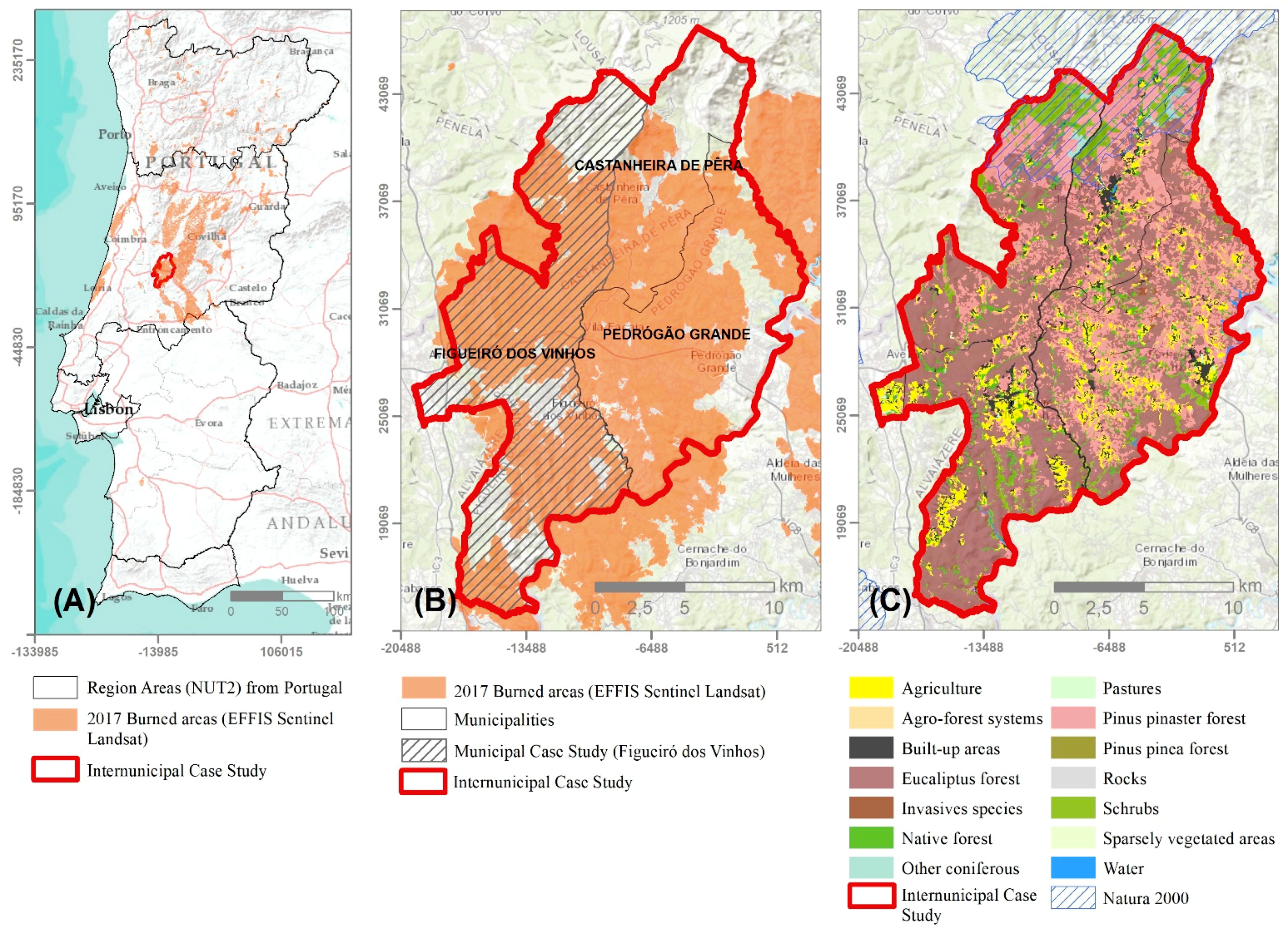
3. Case Study
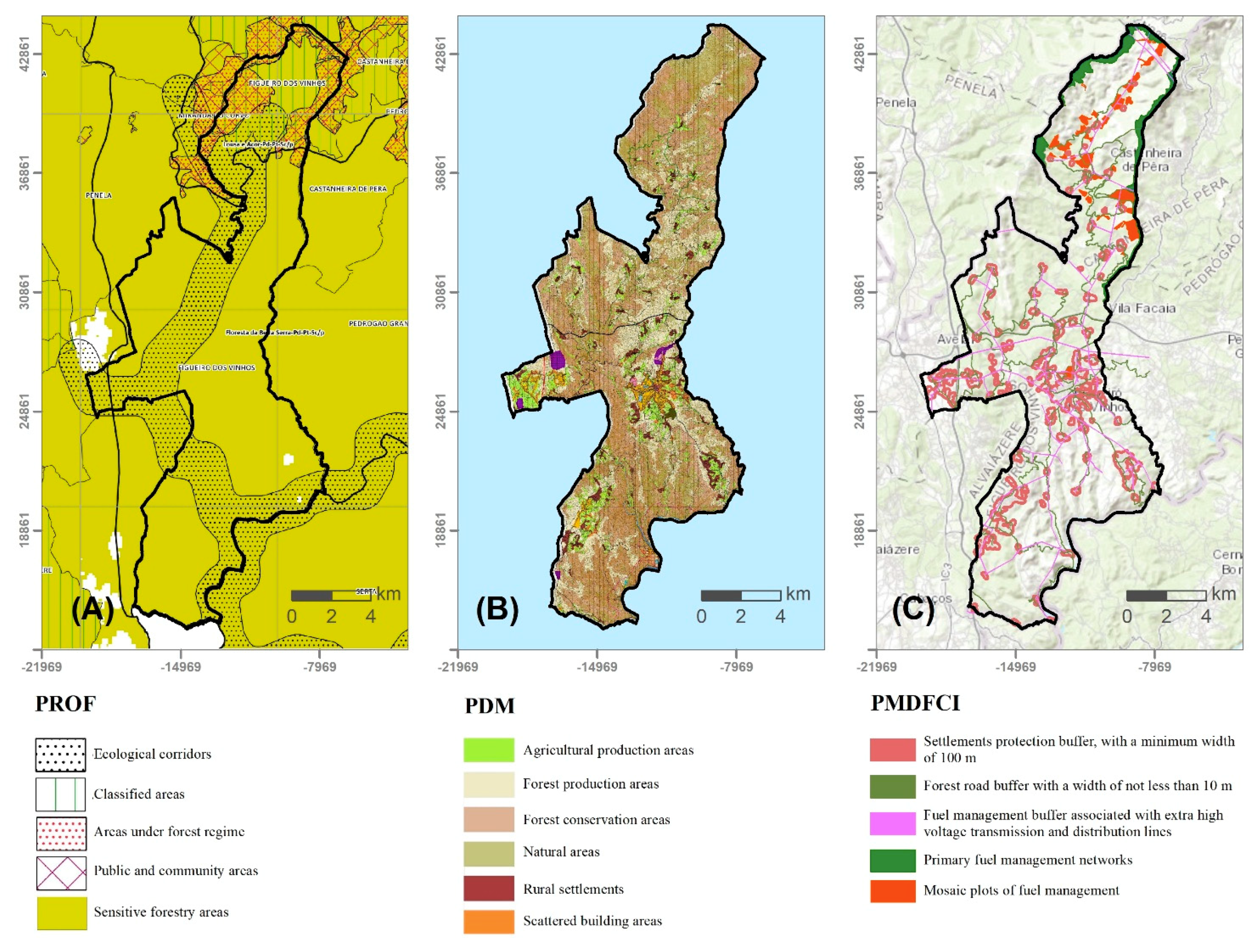
Forest and Fire Planning Framework
4. Method
4.1. FIRELAN Conceptual Model
4.2. FIRELAN GIS Model
4.2.1. FIRELAN Network Components
Ecological Components
- (i)
- (ii)
- Valley bottoms as a broad concept, which comprehends, not only floodplains, but also flat and concave areas, contiguous to streams, in which slope is less than 5% [79].
- (iii)
- Headwater system as the area between the ridgeline and the beginning of the streams network, whose beginning is considered with drainage area of 0.1 km² [77].
- (iv)
- Ridges are based on the river basins limit using drainage dimension and streams length criteria [76].
- (v)
- Hilltops are upper areas of the drainage basin, defined as flat or convex areas with slope < 5% [75]. These areas vary in width due to erosion processes. The narrower forms correspond to the ridgeline and the wider ones to large hilltops, which are commonly referred to as plateaus.
- (vi)
- Swales and ponds are fire-retardant techniques built along the contour lines having a berm downslope [47] with a native broadleaf trees ribbon and associated ponds. The most important swales are those that follow the key-line and the baseline. Swales do not necessarily need to be continuous, but they must not be placed on slopes greater than 25%. The swales must be associated with a mulching technique, consisting of a straw layer or organic waste deposited on soil surface [48,49]. For this purpose, sacrificial trees can be used to cut the branches for deposition on the ground. These components were not mapped due to the required level of detail.
- (vii)
- The soils of high ecological value [80] include soils with considerable soil depth and highest rates of fertility, e.g., Fluvisols, Anthrosols, Humic Cambisols (FAO and WRB classifications) and Alluvial Soils (Portuguese classification) as well as soils associated with traditional agroforestry ecosystems, with specific ecosystems, e.g., marshes. This soil evaluation was performed for mainland Portugal [81], and it is similar to the concept of soil quality [82]. These areas must be allocated to agriculture, wherever possible, providing good management of the soil and of the natural resources. Furthermore, agriculture constitutes a discontinuity of fuel material, fundamental to increase the fire resilience of the landscape.
- (viii)
- Steep slope areas are areas with slope greater than 25% associated with high erosion levels and soil loss because of superficial or deep mass movements. The fire spreads more quickly in these areas, so fire-retardant land-uses must be ensured. The mapping was performed in GIS using a 25 m Digital Terrain Model [78], and the slope tool for spatial analyst.
- (ix)
- Dominant wind exposure areas are locations where the fire increases its intensity and speed. These areas are located generally on the hillslope exposed to the dominant winds’ direction (North-Northwest, in Portugal) and, in mountainous regions particularly along the ridgeline. Thus, in those areas must be ensured wind protection edges with fire-retardant species and adequate land-use. In this case study, the wind protection function is considered within the headwater systems allocated land-uses.
- (x)
- Vegetation areas with very high and high conservation interest have high floristic richness, endangerment, naturalness, rarity and replicability. These areas were mapped based on the predictive methodology of communities and habitats and on the potential vegetation map, which considers the communities’ intrinsic value [83]. Therefore, these areas must be maintained, as they constitute important genetic banks.
- (xi)
- Natura 2000 areas include Special Areas of Conservation (SAC) created under the Habitats Directive, and the Special Protection Areas (SPAs), national parks, nature parks, nature reserves, protected landscapes, natural monuments and protected areas with private status. In Portugal, the Natura 2000 includes 60 SACs and SPAs. The data is available in the EEA platform and the ICNF geoportal.
Cultural Components
- (i)
- (ii)
- Urban and rural settlements protection buffer area, where the land use must be restricted to low-fuel activities such as agriculture, grazing, native or archaeophytes broadleaved trees. Its width varies between 100 m in settlements, and up to 30 m in isolated buildings (Decree-Law n° 10/2018). The data used was from the OpenStreetMap© (Open Knowledge Foundation, London, UK) and the different buffers were mapped using the buffer tool from Esri® software (ArcGIS Desktop1: Release 10.7, Environmental Systems Research Institute, Redlands, CA, USA).
- (iii)
- Road infrastructure protection buffer area, where the land use must be restricted to low-fuel activities such as agriculture, grazing, native or archaeophytes broadleaved trees, in wide lanes: 100 m on motorways, 50 m on national roads, 10 m on municipal roads and 5 m on vicinal ways. The data used was from the OpenStreetMap © and the different buffers were mapped using the buffer tool from ArcGIS.
- (iv)
- Power and communication infrastructures protection buffer area defined with different widths ranging from 15 to 45 m following the Portuguese law (Implementing-Decree n° 1/92 de 18/2/1992). In these areas the land use must be restricted to low-fuel activities such as agriculture, grazing (meadows) or small native shrubs. The different buffers were mapped using the buffer tool from ArcGIS.
4.2.2. FIRELAN Complementary Areas Components
- (i)
- Maximum infiltration areas have high permeability resulting from the evaluation of geology, soil, slope and land cover [85]. They guarantee freshwater supplies and water availability (groundwater recharge), contributing to decreasing the runoff and erosive processes. These areas increase fire resilience and increase soil and water conservation if they have suitable land use covers, namely biodiverse pastures, native bushes or native or archaeophytes broadleaved trees.
- (ii)
- Areas with high soil erosion risks depend on soil characteristics, the length of the hillslopes, and precipitation amount per time unit. In addition to the steep slope areas (slope above 25%) these areas also include hillslope under 25%. These soil erosion risks should be prevented with the appropriate land use cover and, if needed, with techniques to promote water infiltration and erosion reduction. The soil erosion risk map was based on the potential soil erosion calculated through erodibility (K), erosivity (R) and the topographic factor (LS) of the Revised Universal Soil Loss Equation [81]. These areas also contribute to fire resilience if they have suitable land use cover.
- (iii)
- Areas with the higher solar radiation quartile present a higher risk of fire occurrence [34]. These areas have higher air and soil temperatures. The annual solar radiation is characterized by latitude and elevation, steepness slope, aspect and effects of shadows cast by surrounding topography [86]. It was calculated using solar radiation tool from Esri® software (ArcGIS Desktop1: Release 10.7, Environmental Systems Research Institute, Redlands, CA, USA), with the mean value of 0.56 for atmospheric transmissivity for the study area. Fire-retardant species should compose the land use cover.
- (iv)
- Vegetation areas with low and very low conservation value correspond to the existent vegetation whose conservation value is not high enough to receive an endangered status, such as annual grasslands and meadows with low biodiversity. The regenerative capacity presented in such areas is important to the wildlife community. Mesquita [83] modeled the data used.
- (v)
- Natural regeneration areas of native species need to be conserved because they have higher restoration success. These areas were not mapped in the case study because it would require fieldwork on a scale of detail than that of this study.
- (vi)
- Edges with native vegetation to ensure biodiversity. The creation or conservation of edges, in agriculture or forest production stands, can protect from dominant winds, decrease evaporation and avoid fire progression. In terraces, edges with stonewalls will allow agriculture or pastures installation, which will introduce fuel voids in those areas. These elements were not mapped in the case study because of the detailed scale needed.
- (vii)
- Low ecological value areas support a wider range of uses. In these areas, it is possible, in the light of the concepts underlying this paper, including fast growing species.
4.3. FIRELAN Potential Land-Uses
5. Results
5.1. FIRELAN Map
5.2. FIRELAN Land-Use Plan and Landscape Transformation Actions
5.3. Comparison between Plans
6. Discussion
7. Conclusions
Supplementary Materials
Author Contributions
Funding
Conflicts of Interest
References
- Thom, D.; Taylor, A.R.; Seidl, R.; Thuiller, W.; Wang, J.; Robideau, M.; Keeton, W.S. Forest structure, not climate, is the primary driver of functional diversity in north-eastern North America. Sci. Total Environ. 2021, 762, 143070. [Google Scholar] [CrossRef] [PubMed]
- Tran, B.N.; Tanase, M.A.; Bennett, L.T.; Aponte, C. High-severity wildfires in temperate Australian forests have increased in extent and aggregation in recent decades. PLoS ONE 2020, 15, e0242484. [Google Scholar] [CrossRef]
- Tedim, F.; Xanthopoulos, G.; Leone, V. Forest Fires in Europe: Facts and Challenges. In Wildfire Hazards, Risks and Disasters, Shroder, J.F., Paton, D., Eds.; Elsevier: Oxford, UK, 2015; pp. 77–99. [Google Scholar] [CrossRef]
- Vigna, I.; Besana, A.; Comino, E.; Pezzoli, A. Application of the Socio-Ecological System Framework to Forest Fire Risk Management: A Systematic Literature Review. Sustainability 2021, 13, 2121. [Google Scholar] [CrossRef]
- San-Miguel-Ayanz, J.; Moreno, J.M.; Camia, A. Analysis of large fires in European Mediterranean landscapes: Lessons learned and perspectives. For. Ecol. Manag. 2013, 294, 11–22. [Google Scholar] [CrossRef]
- EEC. Council Regulation (EEC) No 2158/92 of 23 July 1992 on Protection of the Community’s Forests Against Fire. 1992. Available online: https://eur-lex.europa.eu/resource.html?uri=cellar:21b27c38-21fb-11e3-8d1c-01aa75ed71a1.0022.01/DOC_1&format=PDF (accessed on 20 May 2020).
- EEC. Council Resolution (EEC) No (1999/C 56/01) of 15 December 1998 on a Forestry Strategy for the European Union. 1998. Available online: https://eur-lex.europa.eu/legal-content/EN/TXT/?uri=CELEX:31999Y0226(01) (accessed on 20 January 2020).
- EC. COM(2006)302 Final. Communication from the Commission to the Council and the European Parliament of 15 June 2006 on an EU Forest Action Plan. 2006. Available online: https://eur-lex.europa.eu/legal-content/EN/TXT/?uri=LEGISSUM%3Al24277 (accessed on 20 May 2020).
- EC. A New EU Forest Strategy: For Forests and the Forest-Based Sector. COM (2013) 659. European Commission. Brussels. 2013. Available online: https://eur-lex.europa.eu/resource.html?uri=cellar:21b27c38-21fb-11e3-8d1c-01aa75ed71a1.0022.01/DOC_1&format=PDF (accessed on 20 May 2020).
- UN. Transforming Our World: The 2030 Agenda for Sustainable Development. 2015. Available online: https://sdgs.un.org/2030agenda (accessed on 20 May 2020).
- EC. The European Green Deal. COM (2019) 640 Final. 2019. Available online: https://ec.europa.eu/info/sites/info/files/european-green-deal-communication_en.pdf (accessed on 20 April 2020).
- EC. EU Biodiversity Strategy for 2030. Bringing Nature Back into Our Lives. COM (2020) 380 Final. 2020. Available online: https://eur-lex.europa.eu/resource.html?uri=cellar:a3c806a6-9ab3-11ea-9d2d-01aa75ed71a1.0001.02/DOC_1&format=PDF (accessed on 20 July 2020).
- Turco, M.; Bedia, J.; Liberto, F.; Fiorucci, P.; Hardenberg, J.; Koutsias, N.; Llasat, M.; Xystrakis, F.; Provenzale, A. Decreasing Fires in Mediterranean Europe. PLoS ONE 2016, 11, e0150663. [Google Scholar] [CrossRef] [Green Version]
- Lourenço, L. Forest fires in continental Portugal. Result of profound alterations in society and territorial consequences. Méditerranée 2018. [Google Scholar] [CrossRef]
- Mateus, P.; Fernandes, P.M. Forest Fires in Portugal: Dynamics, Causes and Policies. In Forest Context and Policies in Portugal; Reboredo, F., Ed.; World Forests; Springer: Cham, Switzerland, 2014; Chapter IV; Volume 19. [Google Scholar] [CrossRef]
- PORDATA Datasource: ICNF/MAAC. 2020. Available online: https://www.pordata.pt/Portugal/Inc%C3%AAndios+rurais+e+%C3%A1rea+ardida+%E2%80%93+Continente-1192 (accessed on 20 May 2020).
- San-Miguel-Ayanz, J.; Durrant, T.; Boca, R.; Libertà, G.; Branco, A.; de Rigo, D.; Ferrari, D.D.; Maianti, P.; Vivancos, T.A.; Schulte, E.; et al. Forest Fires in Europe, Middle East and North Africa 2016; Publications Office: Luxembourg, 2017; ISBN 978-92-79-71292-0. [Google Scholar] [CrossRef]
- Beighley, M.; Hyde, A.V. Gestão dos Incêndios Florestais em Portugal numa Nova Era Avaliação dos Riscos de Incêndio, Recursos e Reformas (Portugal Wildfire Management in a New Era). 2018. Available online: https://www.isa.ulisboa.pt/files/cef/pub/articles/201804/2018_Portugal_Wildfire_Management_in_a_New_Era_Portuguese.pdf (accessed on 20 January 2020).
- Magalhães, M.R. Para uma Intervenção no Espaço Rural Português in Serrão, A.V. (coord.) Filosofia e Arquitectura da Paisagem; Intervenções; Centro de Filosofia da Universidade de Lisboa: Lisboa, Portugal, 2013; pp. 163–175. ISBN 978-989-8553-20-1. [Google Scholar]
- Baptista, O.F. Declínio de um tempo longo (Long time decline). In Agriculturas e Territórios; Celta: Oeiras, Portugal, 2001; pp. 9–37. [Google Scholar]
- Nunes, A.N.; Lourenço, L.; Meira, A.C.C. Exploring spatial patterns and drivers of forest fires in Portugal (1980–2014). Sci. Total Environ. 2016, 573, 1190–1202. [Google Scholar] [CrossRef] [PubMed]
- DGT. Land Use and Land Cover Map. 2020. Available online: https://snig.dgterritorio.gov.pt/ (accessed on 20 January 2020).
- EFFIS. Map of Burned Area from 2018. 2019. Available online: https://effis.jrc.ec.europa.eu/static/effis_current_situation/public/index.html (accessed on 20 January 2020).
- Tedim, F.; Leone, V.; McGee, T. Extreme Wildfire Events and Disasters: Root Causes and New Management Strategies; Elsevier: Amsterdam, The Netherlands, 2019; ISBN 9780128157213. [Google Scholar]
- Observatório Técnico Independente (OTI). Aprovação dos Planos Regionais de Ordenamento Florestal: Uma Oportunidade Perdida! (Regional Forest Landscape Plans (PROF) Approval: A Lost Opportunity!) Nota informativa 1/2019. Assembleia da República. 2019. Available online: https://www.parlamento.pt/Documents/2019/fevereiro/Nota-Informativa_1-2019_OTI.pdf (accessed on 20 April 2020).
- PROF Centro Litoral—Portaria n.° 56/2019—Diário da República n.° 29/2019, Série I de 2019-02-11 2019. Available online: https://dre.pt/application/file/a/119388383 (accessed on 20 April 2020).
- Walker, B.; Holling, C.S.; Carpenter, S.R.; Kinzig, A. Resilience, adaptability and transformability in social–ecological systems. Ecol. Soc. 2004, 9. Available online: http://www.ecologyandsociety.org/vol9/iss2/art5/ (accessed on 20 June 2020). [CrossRef]
- Ahern, J. From fail-safe to safe-to-fail: Sustainability and resilience in the new urban world. Landsc. Urban. Plan. 2011, 100, 341–343. [Google Scholar] [CrossRef] [Green Version]
- Marey-Perez, M.; Loureiro, X.; Corbelle-Rico, E.J.; Fernández-Filgueira, C. DifferentStrategies for Resilience to Wildfires: The Experience of Collective LandOwnership in Galicia (NorthwestSpain). Sustainability 2021, 13, 4761. [Google Scholar] [CrossRef]
- Magalhães, M.R.; Abreu, M.M.; Lousã, M.; Cortez, N. Estrutura Ecológica da Paisagem. In Conceitos e Delimitação—Escalas Regional e Municipal; ISApress: Lisboa, Portugal, 2007. [Google Scholar]
- Rothermel, R.C. How to Predict the Spread and Intensity of Forest and Range Fires; Report No. INT-143; Intermountain Forest and Range Experiment Station: Ogden, UT, USA, 1983. [Google Scholar]
- Moreira, F.; Duarte, I.; Catry, F.; Acácio, V. Cork extraction as a key factor determining post-fire cork oak survival in a mountain region of southern Portugal. For. Ecol. Manag. 2007, 253, 30–37. [Google Scholar] [CrossRef]
- Heyerdahl, E.K.; Brubaker, L.B.; Agee, J.K. Spatial Controls of Historical Fire Regimes: A Multiscale Example from the Interior West, USA. Ecology 2010, 82, 660–678. [Google Scholar] [CrossRef]
- Coen, J.L.; Schroeder, W. The High Park Fire: Coupled weather-wildland fire model simulation of a windstorm-driven wildfire in Colorado’s Front Range. J. Geophys. Res. Atmos. 2015, 120, 131–146. [Google Scholar] [CrossRef]
- Oliveira, S.; Moreira, F.; Boca, R.; San-Miguel-Ayanz, J.; Pereira, J.M.C. Assessment of fire selectivity in relation to land cover and topography: A comparison between Southern European countries. Int. J. Wildland Fire 2014, 23, 620–630. [Google Scholar] [CrossRef]
- Viegas, D.X.; Lourenço, L. Os Incêndios Florestais na Região Centro; Revista Sociedade e Território: Porto, Portugal, 1989. [Google Scholar]
- Viegas, D.X. Parametric study of Eruptive Fire Behaviour Model. Int. J. Wildland Fire 2006, 15, 169–177. [Google Scholar] [CrossRef]
- Dickinson, M.B.; Hutchinson, T.F.; Dietenberger, M.; Matt, F.; Peters, M.P. Litter Species Composition and Topographic Effects on Fuels and Modeled Fire Behavior in an Oak-Hickory Forest in the Eastern USA. PLoS ONE 2016, 11, e0159997. [Google Scholar] [CrossRef] [PubMed]
- Calviño-Cancela, M.; Chas-Amil, M.L.; García-Martínez, E.D.; Touza, J. Interacting effects of topography, vegetation, human activities and wildland-urban interfaces on wildfire ignition risk. For. Ecol. Manag. 2017, 397, 10–17. [Google Scholar] [CrossRef] [Green Version]
- Silva, J.S.; Moreira, F.; Vaz, P.; Catry, F.; Godinho-Ferreira, P. Assessing the relative fire proneness of different forest types in Portugal. Plant Biosyst. 2009, 143, 597–608. [Google Scholar] [CrossRef]
- Pereira, M.; Aranha, J.; Amraoui, M. Land cover fire proneness in Europe Forest Systems. For. Syst. 2014, 23, 598. [Google Scholar] [CrossRef]
- Carmo, M.; Moreira, F.; Casimiro, P.; Vaz, P. Land use and topography influences on wildfire occurrence in northern Portugal. Landsc. Urban. Plan. 2011, 100, 169–176. [Google Scholar] [CrossRef] [Green Version]
- Moreira, F.; Vaz, P.; Catry, F.; Silva, J.S. Regional variations in wildfire susceptibility of land-cover types in Portugal: Implications for landscape management to minimize fire hazard. Int. J. Wildland Fire 2009, 18, 563–574. [Google Scholar] [CrossRef]
- Povak, N.A.; Hessburg, P.F.; Salter, R.B. Evidence for scale-dependent topographic controls on wildfire spread. Ecosphere 2018, 9, e02443. [Google Scholar] [CrossRef] [Green Version]
- Agee, J.K.; Bahro, B.; Finney, M.A.; Omi, P.N.; Sapsis, D.B.; Skinner, C.N.; Wagtendonk, J.W.; Weatherspoon, P.C. The use of shaded fuelbreaks in landscape fire management. For. Ecol. Manag. 2000, 127, 55–66. [Google Scholar] [CrossRef]
- Forestry Commission. Building wildfire resilience into forest management planning. In Forestry Commission PraCalvinoctice Guide; Forestry Commission: Edinburgh, UK, 2014; ISBN 978-0-85538-886-7. [Google Scholar]
- Mollison, B. Permaculture. A Designers’ Manual; Tagari Publications: Sisters Creek, Australia, 1988. [Google Scholar]
- Fernández, C.; Vega, J.A.; Jiménez, D.C.S.; Vieira, A.; Merino, A.; Ferreiro, A.; Fonturbel, T. Seeding and mulching+seeding effects on post-fire runoff, soil erosion and species diversity in Galicia (NW Spain). Land Degrad. Dev. 2010, 23, 150–156. [Google Scholar] [CrossRef]
- Keizer, J.; Silva, F.C.; Vieira, D.C.S.; González-Pelayo, O.; Campos, I.; Vieira, A.M.D.; Valente, S.; Prats, S.A. The effectiveness of two contrasting mulch application rates to reduce post-fire erosion in a Portuguese eucalypt plantation. Catena 2018, 169, 21–30. [Google Scholar] [CrossRef]
- Calviño-Cancela, M.; Chas-Amil, M.L.; García-Martínez, E.D.; Touza, J. Wildfire risk associated with different vegetation types within and outside wildland-urban interfaces. For. Ecol. Manag. 2016, 372, 1–9. [Google Scholar] [CrossRef] [Green Version]
- Bento-Gonçalves, A.; Vieira, A. Wildfires in the wildland-urban interface: Key concepts and evaluation methodologies. Sci. Total. Environ. 2020, 707, 1. [Google Scholar] [CrossRef]
- Gibbons, P.; Gill, A.M.; Shore, N.; Moritz, M.A.; Dovers, S.; Cary, G.J. Options for reducing house-losses during wildfires without clearing trees and shrubs. Landsc. Urban. Plan. 2018, 174, 10–17. [Google Scholar] [CrossRef]
- Badia, A.; Pallares-Barbera, M.; Valldeperas, N.; Gisbert, M. Wildfires in the wildland-urban interface in Catalonia: Vulnerability analysis based on land use and land cover change. Sci. Total. Environ. 2019, 673, 184–196. [Google Scholar] [CrossRef] [PubMed]
- Callicott, J.B.; Mumford, K. Ecological Sustainability as a Conservation Concept. Conserv. Biol. 1997, 11, 32–40. [Google Scholar] [CrossRef]
- Termorshuizen, J.W.; Opdam, P.; Van den Brink, A. Incorporating ecological sustainability into landscape planning. Landsc. Urban. Plan. 2007, 79, 374–384. [Google Scholar] [CrossRef]
- Forman, R.T.T. Land Mosaics: The Ecology of Landscapes and Regions; Cambridge University Press: Cambridge, UK, 1995. [Google Scholar]
- Magalhães, M.R. A Arquitectura Paisagista—Morfologia e Complexidade; Editorial Estampa: Lisboa, Portugal, 2001; p. 525. [Google Scholar]
- Cunha, N.S.; Magalhães, M.R. Methodology for mapping the national ecological network to mainland Portugal: A planning tool towards a green infrastructure. Ecol. Indic. 2019, 104, 802–818. [Google Scholar] [CrossRef]
- McHarg, I. Design with Nature; John Wiley and Sons: New York, NY, USA, 1967. [Google Scholar]
- Ahern, J. Greenways as planning strategy. Landsc. Urban. Plan. 1995, 33, 131–155. [Google Scholar] [CrossRef]
- Fabos, J.G. Greenway planning in the United States: Its origins and recent case studies. Landsc. Urban. Plan. 2004, 68, 321–342. [Google Scholar] [CrossRef]
- Lennon, M.; Scott, M.; Collier, M.; Foley, K. Developing green infrastructure “thinking”: Devising and applying an interactive group-based methodology for practitioners. J. Environ. Plan. Manag. 2015, 59, 843–865. [Google Scholar] [CrossRef]
- Liquete, C.; Kleeschulte, S.; Dige, G.; Maes, J.; Grizzetti, B.; Olah, B.; Zulian, G. Mapping green infrastructure based on ecosystem services and ecological networks: A Pan-European case study. Environ. Sci. Policy 2015, 54, 268–280. [Google Scholar] [CrossRef]
- Magalhães, M.R. Estrutura Ecológica Nacional—Uma Proposta de Delimitação e Regulamentação; ISApress: Lisboa, Portugal, 2013; ISBN 978-972-8669-53-9. [Google Scholar]
- EC. Green Infrastructure (GI)—Enhancing Europe’s Natural Capital. COM (2013) 249 Final. 2013. Available online: https://eur-lex.europa.eu/legal-content/EN/TXT/?uri=CELEX:52013DC0249 (accessed on 20 May 2020).
- Čivić, K.; Jones-Walters, L.M. Implementing green infrastructure and ecological networks in europe: Lessons learned and future perspectives. J. Green Eng. 2015, 4, 307–324. [Google Scholar] [CrossRef]
- FAO. A Framework for Land Evaluation. FAO Soils Bulletin 32. Rome. ISBN 92-5-100111-1. 1976. Available online: http://www.fao.org/3/x5310e/x5310e00.htm (accessed on 20 December 2020).
- Collins, M.G.; Steiner, F.R.; Rushman, M.J. Land-use suitability analysis in the United States: Historical development and promising technological achievements. Environ. Manag. 2001, 28, 611–621. [Google Scholar] [CrossRef]
- Magalhães, M.R. Ordem Ecológica e Desenvolvimento. O futuro do território português. In Ecological Order and Development. The Future of Portuguese Territory; ISApress: Lisboa, Portugal, 2016; ISBN 978-972-8669-53-9. [Google Scholar]
- ICNF. Cartografia da Perigosidade Estrutural 2020–2030. 2020. Available online: http://www2.icnf.pt/portal/florestas/dfci/inc/cartografia/cartografia-risco-classes-perigosidade (accessed on 20 June 2020).
- EFFIS. Map of Burned Area from 2017. 2017. Available online: https://effis.jrc.ec.europa.eu/static/effis_current_situation/public/index.html (accessed on 20 January 2020).
- PMDFCI. Fire Protection Municipal Plan from Figueiró dos Vinhos 3ª Geração (Despachos n°s 443A/2018 e 1222B/2018). 2018. Available online: https://fogos.icnf.pt/infoPMDFCI/ (accessed on 20 May 2020).
- PDM. Land-Use Plan from Figueiró dos Vinhos. 2015. Available online: https://www.dgterritorio.gov.pt/ordenamento/sgt/igt-vigor (accessed on 20 May 2020).
- Magalhães, M.R. The Ecological Structure of Lisbon. Ekistics 1993, 60, 159–166. [Google Scholar]
- Cunha, N.S.; Magalhães, M.R.; Domingos, T.; Abreu, M.M.; Withing, K. The land morphology concept and mapping method and its application to mainland Portugal. Geoderma 2018, 325, 72–89. [Google Scholar] [CrossRef]
- Silva, J.F.; Cunha, N.; Lopes, A.M.; Abreu, M.M.; Magalhães, M.R. Litoral (Coast). In Estrutura Ecológica Nacional; Magalhães, M.R.M., Ed.; Uma Proposta de Delimitação e Regulamentação (National Ecological Network. A Delimitation and Regulation Proposal); ISAPress: Lisboa, Portugal, 2013; pp. 67–82. ISBN 978-972-8669-53-9. [Google Scholar]
- Pena, S.B.; Magalhães, M.R.; Abreu, M.M. Mapping headwater systems using a HS-GIS model. An application to landscape structure and land use planning in Portugal. Land Use Policy 2018, 71, 543–553. [Google Scholar] [CrossRef]
- INAG. Hidrografia. (Hydrography). In InterSIG—Gestor de Informação Geográfica; Instituto Nacional da Água; I.P. Agência Portuguesa Ambiente: Lisboa, Portugal, 2010. [Google Scholar]
- Cunha, N.S.; Magalhães, M.R.; Domingos, T.; Abreu, M.M.; Küpfer, C. The land morphology approach to flood risk mapping: An application to Portugal. J. Environ. Manag. 2017, 193, 172–187. [Google Scholar] [CrossRef]
- Cortez, N. Subsistema Solo (Soil Subsystem). In Estrutura Ecológica da Paisagem; Magalhães, M.R., Abreu, M.M., Lousã, M., Cortez, N., Eds.; Conceitos e Delimitação-Escalas Regional e Municipal (Landscape Ecological Network. Concepts and Delimitation-Regional and Municipal Scales); ISApress: Lisboa, Portugal, 2007. [Google Scholar]
- Pena, S.B.; Abreu, M.M.; Magalhães, M.R.; Cortez, N. Water erosion aspects of land degradation neutrality to landscape planning tools at national scale. Geoderma 2020, 363, 114093. [Google Scholar] [CrossRef]
- Leitão, M.; Cortez, N.; Pena, S.B. Solo (Soil). In Estrutura Ecológica Nacional; Magalhães, M.R.M., Ed.; Uma Proposta de Delimitação e Regulamentação (National Ecological Network. A Delimitation and Regulation Proposal); ISAPress: Lisboa, Portugal, 2013; pp. 83–104. ISBN 978-972-8669-53-9. [Google Scholar]
- Mesquita, S. Vegetação. In Estrutura Ecológica Nacional; Magalhães, M.R.M., Ed.; Uma Proposta de Delimitação e Regulamentação (National Ecological Network. A Delimitation and Regulation Proposal); ISAPress: Lisboa, Portugal, 2013; pp. 105–120. ISBN 978-972-8669-53-9. [Google Scholar]
- Moreira, F.; Pe’er, G. Agricultural policy can reduce wildfire. Science 2018, 359, 1001. [Google Scholar] [CrossRef] [PubMed]
- Pena, S.B.; Abreu, M.M.; Magalhães, M.R. Planning landscape with water infiltration. Empirical model to assess maximum infiltration areas in Mediterranean Landscapes. Water Resour. Manag. 2016, 30, 2343–2360. [Google Scholar] [CrossRef]
- Fu, P.; Rich, P.M. The Solar Analyst 1.0 Manual; Helios Environmental Modeling Institute (HEMI): New York, NY, USA, 2000. [Google Scholar]
- Mesquita, S.; Capelo, J. Aptidão Bioclimática às Espécies Arbóreas (Bioclimatic Suitability of tree species). In Ordem Ecológica e Desenvolvimento; Magalhães, M.R., Ed.; O futuro do território português (Ecological Order and Development. The future of Portuguese territory); ISAPress: Lisboa, Portugal, 2016; pp. 63–85. ISBN 978-972-8669-53-9. [Google Scholar]
- Molchanov, A.A. Hidrologia Florestal; Fundação Calouste Gulbenkian: Lisboa, Portugal, 1971. [Google Scholar]
- FAO. Fire Management: Voluntary Guidelines. Principles and Strategic Actions. Fire Management Working Paper 17. Rome. 2006. Available online: http://www.fao.org/3/j9255e/J9255E00.htm (accessed on 20 December 2020).
- Magalhães, M.R.; Baptista, F.O.; Cunha, N.; Müller, A.; Pena, S.B.; Silva, J.; Leitão, M. A dimensão humana dos incêndios florestais. In O Ordenamento do Território na Prevenção dos Incêndios Rurais; Tedim, F., Paton, D., Eds.; Estratégias Criativas: Porto, Portugal, 2012; pp. 55–99. [Google Scholar]
- Fernandes, P.M. Fire-smart management of forest landscapes in the Mediterranean basin under global change. Landsc. Urban. Plan. 2013, 110, 175–182. [Google Scholar] [CrossRef] [Green Version]
- Pais, S.; Aquilué, N.; Campos, J.; Sil, A.; Marcos, B.; Martínez-Freiría, F.; Domínguez, J.; Brotons, L.P.; Honrado, J.P.; Regos, A. Mountain farmland protection and fire-smart management jointly reduce fire hazard and enhance biodiversity and carbon sequestration. Ecosyst. Serv. 2020, 44, 101143. [Google Scholar] [CrossRef]
- Foresta, M.; Carranza, M.L.; Garfì, V.; Febbraro, M.D.; Marchetti, M.; Loy, A. A systematic conservation planning approach to fire risk management in Natura 2000 sites. J. Environ. Manag. 2016, 181, 574–581. [Google Scholar] [CrossRef]
- Sheppard, J.P.; Chamberlain, J.; Agúndez, D.; Bhattacharya, P.; Chirwa, P.W.; Gontcharov, A.; Sagona, W.C.; She, H.; Tadesse, W.; Mutke, S. Sustainable Forest Management Beyond the Timber-Oriented Status Quo: Transitioning to Co-production of Timber and Non-wood Forest Products—A Global Perspective. For. Manag. 2020, 6, 26–40. [Google Scholar] [CrossRef] [Green Version]


| Fire Resilient and Sustainable Landscape Model (FIRELAN) | Area (ha) | % Total Study Area | |||
|---|---|---|---|---|---|
| FIRELAN Network | Linear Features | 17,094 | 29,221 | 46.4 | 79.4 |
| Areas * | 12,128 | 32.9 | |||
| FIRELAN Complementary Areas ** | with Ecological Value | 4270 | 6415 | 11.6 | 17.4 |
| with low Ecological Value | 2146 | 5.8 | |||
| Cultural system | Urban and rural settlements | 1121 | 1187 | 3 | 3.2 |
| Road infrastructure | 66 | 0.2 | |||
| Proposed Land-Use Plan Classes | Total Area (ha) | % of Total Case Study Area | FIRELAN Components (Main) |
|---|---|---|---|
| Agriculture (edges of mixed woods—native/archaeophytes and cupressus trees) | 246 | 0.67 | Headwater systems and High ecological value soils |
| Native/archaeophytes broadleaved trees or shrubs | 10,352 | 28.11 | Steep slope areas |
| Native/archaeophytes broadleaved trees or permanent meadow | 1762 | 4.79 | Ridge line |
| Mixed woods (native/archaeophytes and cupressus trees) or permanent meadow | 113 | 0.30 | Hilltops |
| Riparian vegetation | 1876 | 5.10 | Streams and narrow valley bottoms |
| Natural regeneration in Natura 2000 | 461 | 1.25 | - |
| Agriculture | 249 | 0.68 | High ecological value soils |
| Mixed woods (native/archaeophytes and cupressus trees) | 7463 | 20.26 | Headwater systems |
| Agriculture or permanent meadow arranged in terraces | 165 | 0.45 | Steep slope areas with ecological value soils |
| Agriculture or/and production forest (including exotic trees), and other land-uses | 2146 | 5.8 | FIRELAN CA with low ecological value |
| Agriculture or/and production forest (excluding high flammable species) | 4270 | 11.6 | FIRELAN CA with ecological value |
| Agriculture, meadow, native species/archaeophytes broadleaved trees | 1733 | 4.71 | Settlement protection buffer |
| Meadow, native/archaeophytes broadleaved trees | 861 | 2.34 | Roads protection buffer |
| Agriculture (small fruit forest), meadow or small native shrubs | 130 | 0.35 | Power infrastructures protection buffer |
| Existent agriculture | 3123 | 8.48 | - |
| Existent vegetation with conservation interest | 310 | 0.84 | - |
| Water bodies | 378 | 1.03 | Water bodies |
| Roads | 66 | 0.18 | - |
| Settlements | 1121 | 3.05 | - |
| Transformation Actions | Area (ha) | % | |||
|---|---|---|---|---|---|
| Areas to be converted into | Native/archaeophytes broadleaved forest in Natura 2000 | 1954 | 26,657 | 5.3 | 72.3 |
| Native/archaeophytes broadleaved forest | 8496 | 23.1 | |||
| Mixed woods in Natura 2000 | 1567 | 4.3 | |||
| Mixed woods | 5745 | 15.6 | |||
| Riparian vegetation | 1401 | 3.8 | |||
| Natural regeneration should be developed in Natura 2000 | 346 | 0.9 | |||
| Agriculture | 446 | 1.2 | |||
| Agriculture or meadows (with terraces) | 143 | 0.4 | |||
| Meadow in roads buffer areas | 804 | 2.2 | |||
| Agriculture (small fruit forest), meadow or small native shrubs under power infrastructures | 101 | 0.3 | |||
| Agriculture, meadow, native species/archaeophytes broadleaved trees in WUI | 1388 | 3.8 | |||
| Maritime pine or eucalyptus | 162 | 0.3 | |||
| Production forest (preferably excluding high flammable species), agriculture or other land-uses | 4104 | 11.1 | |||
| Areas to be conserved | Maritime pine and eucalyptus to be maintained | 2027 | 8587 | 5.5 | |
| Areas to be maintained and conserved | 6560 | 17.9 | |||
| Rocks | 12 | 0.03 | |||
| Settlements | 1121 | 3.0 | |||
| Roads | 66 | 0.2 | |||
| Water bodies | 380 | 1.0 | |||
| FIRELAN vs. PMDFCI | Area (ha) | % of the Case Study Area |
|---|---|---|
| Areas with FIRELAN N without PMDFCI | 12,588 | 72.7 |
| Areas with FIRELAN N and PMDFCI | 2934 | 16.9 |
| Areas without FIRELAN N with PMDFCI | 116 | 0.7 |
| Areas without FIRELAN N and without PMDFCI | 1684 | 9.7 |
| FIRELAN Network (Linear) vs. PMDFCI | Area (ha) | % of the Case Study Area |
|---|---|---|
| Areas with FIRELAN N (linear), without PMDFCI | 6311 | 36.4 |
| Areas with FIRELAN N (linear) and PMDFCI | 2402 | 13.9 |
| Areas without FIRELAN N (linear), with PMDFCI | 647 | 3.7 |
| Areas without FIRELAN N (linear) and without PMDFCI | 7961 | 46.0 |
Publisher’s Note: MDPI stays neutral with regard to jurisdictional claims in published maps and institutional affiliations. |
© 2021 by the authors. Licensee MDPI, Basel, Switzerland. This article is an open access article distributed under the terms and conditions of the Creative Commons Attribution (CC BY) license (https://creativecommons.org/licenses/by/4.0/).
Share and Cite
Magalhães, M.R.; Cunha, N.S.; Pena, S.B.; Müller, A. FIRELAN—An Ecologically Based Planning Model towards a Fire Resilient and Sustainable Landscape. A Case Study in Center Region of Portugal. Sustainability 2021, 13, 7055. https://doi.org/10.3390/su13137055
Magalhães MR, Cunha NS, Pena SB, Müller A. FIRELAN—An Ecologically Based Planning Model towards a Fire Resilient and Sustainable Landscape. A Case Study in Center Region of Portugal. Sustainability. 2021; 13(13):7055. https://doi.org/10.3390/su13137055
Chicago/Turabian StyleMagalhães, Manuela R., Natália S. Cunha, Selma B. Pena, and Ana Müller. 2021. "FIRELAN—An Ecologically Based Planning Model towards a Fire Resilient and Sustainable Landscape. A Case Study in Center Region of Portugal" Sustainability 13, no. 13: 7055. https://doi.org/10.3390/su13137055
APA StyleMagalhães, M. R., Cunha, N. S., Pena, S. B., & Müller, A. (2021). FIRELAN—An Ecologically Based Planning Model towards a Fire Resilient and Sustainable Landscape. A Case Study in Center Region of Portugal. Sustainability, 13(13), 7055. https://doi.org/10.3390/su13137055