Article

Urban Design and Rivers: A Critical Review of Theories Devising Planning and Design Concepts to Define Riverside Urbanity

by
Laurence Pattacini
Department of Landscape Architecture, University of Sheffield, Sheffield S7 1HN, UK
Sustainability 2021, 13(13), 7039; https://doi.org/10.3390/su13137039
Submission received: 23 May 2021 / Revised: 10 June 2021 / Accepted: 15 June 2021 / Published: 23 June 2021
(This article belongs to the Special Issue Urbanism and Rivers or Riverside Urbanity?)

Abstract

:
In a post-industrial world one of the foci of urbanism has been on the regeneration of former industrial sites along urban rivers. This is a contemporary urban design issue that needs further attention, especially in relation to urban forms and design interventions. This paper sets out to contribute to research in design by reviewing past theories and practices in order to inform the formation of conceptual ideas. These are of importance to inform practice and ensure responsive and responsible processes in planning and design. Such a review has hitherto been lacking, but with a renewed interest in urban densification, research in the design of cities is required. Thus, this paper provides a critical assessment of theories, which are identified and categorised in relation to urban riverside regeneration. For this study, urban design is considered as a craft requiring ‘savoir faire’ to ensure the functionality and quality of urban spaces. Transferable principles and ideas are identified in relation to the specific characteristics of riverside locations contributing to the definition of a ‘riverside urbanity’. It provides a theoretical framework identifying types of riverside landscapes, including the relationship between urban forms and river corridors.

Graphical Abstract

1. Introduction: Rivers and Urban Development

Rivers have been instrumental in the location and development of vernacular towns and cities. As industrial cities developed, rivers have often been forgotten, canalised, or have even disappeared into culverts. However, with the departure of industries from city centre locations, rivers have become cleaner, less smelly, and less unsightly. River corridors are now valued as an amenity providing contact with nature and opportunities for leisure activities. They play an important role in providing valuable ecosystem services through potentially rich riverine ecosystems and their amenity values [1]. Consequently, vacant former industrial sites in riverside locations are often at the heart of urban regeneration projects [2,3,4,5]. The brownfield sites in riverside locations offer unique opportunities for new mixed-use developments with strong identities and responding to the sustainable living agenda. Water management in riverside locations has also become one of the main concerns in relation to climate change with an increase in the number of dramatic flood events in urban environments [6,7]. It is therefore timely to explore ideas on good practice related to the planning and design of built forms in riverside locations. Urban river corridors are often considered in isolation, detached from the built forms which surround them. The majority of publications on urban rivers focus on the ecological values of the river corridors or specific design projects on river embankments [8,9,10,11,12]. This paper argues that rivers in cities have a much wider field of influence, well beyond the profile of the corridor and the physical characteristics of riverbanks. The impact of rivers on urban forms will be discussed and illustrated through the identification and review of references to rivers in key texts related to urban design theories and practice.
This paper aims to contribute to research related to design to inform the decision-making process for the urban regeneration of riverside sites. Design practitioners need an evidence-based theoretical framework to inform design decision making processes and address the complex issues related to environmental responsibilities and well-being [13]. The significance of the anthology of texts related to urbanism is its contribution to knowledge, reviewing key publications in the field of urbanism in order to identify transferable ideas and principles specifically related to urban development along rivers. This is part of ongoing doctoral research concerned with the regeneration of former industrial sites along urban rivers in Northern Europe. The ideas and principles identified and categorised in this paper related to urban riverside regeneration provide relevant information to influence the generation of conceptual ideas and contribute to planning tools and reference documents. This can be applied following models mentioned in the literature looking at the research and design relationship as listed below [13] (p. 49):
  • Providing criteria to modify and test design proposals;
  • The development of generic principles to assess the quality and relevance of design options;
  • Providing an intellectual framework underpinned by reliable evidence;
  • An understanding of relevant issues and problems related to specific site characteristics and uses.

2. Materials and Methods: Selection of Texts, Review and Analysis

The research undertaken relies on texts studying the evolution of city development as well as texts written by urban designers putting forward design principles and guidance to inform urban forms. The texts are selected for their significance to form a representative sample of key ideas, principles and theories related to urbanism and urban design with specific reference to urban rivers and riverside developments. This literature review draws from Françoise Choay’s anthology on urbanism entitled l’ Urbanisme utopies et realites [14]. In this book, she examines schools of thought and philosophies, exploring ideas underpinning contemporary urbanism. The review adopts Choay’s definition of urbanism: ‘a reflective and critical discipline concerned with urban forms and their evolution; a compilation of ideas’ [14] (pp. 8–9). It also adopts her proviso that the origin of urbanism as a discipline dates from 1867 when Cerda coined the term urbanism in his Theoria general de Urbanizacion (general theory of urbanism). Cerda formalised key urban design principles following the rapid expansion of cities during the industrial revolution in Europe. Principles related to hygiene and circulation in cities had been considered before, but Cerda was the first to articulate the specificity of the new discipline. He referred to a structural framework for the understanding of urban forms and the elaboration of urban plans, drawing from the discipline of natural science with terms such as ‘classification’, ‘system’, ‘nucleus’ and ‘cells’ [15].
The list of texts consulted provides a representative sample of references related to the field of urbanism post 1867 and covers texts in several European languages. The selection relied on bibliographies in books and academic journal articles as well as specialised literature reviews [16,17,18,19,20,21,22]. It also includes books listed in the ‘ideal library of urban design’ of the UK Urban Design Group. For this review, the texts consulted to identify specific references to urban rivers and riverside sites concern all scales of interventions and all geographical locations. The review searched for key words including river, riverside, water and waterfront.
The publications consulted belong to different types of publications including:
  • Generic reference books on the history of urbanism, urban forms, city planning and design;
  • Text and/or design proposals related to utopian concepts or cities by urbanists and/or architects;
  • More specific principles/theories and practical guidance on the design of urban forms written by a specific urbanist/designer.
Urbanism is influenced by sociopolitical and economic factors, and therefore, the texts reviewed are a product of their time. For this reason, this study focuses primarily on spatial qualities and recommendations related to built forms and design practices. The literature review identifies specific quotes related to rivers in urban environments but also draws from visual illustrations of urban forms on riverside locations. As highlighted earlier, the focus here is on identifying transferable principles rather than finding specific design solutions. Contextual information including site specificity and character are essential to urban design practices, but at the inception of the design process key principles and guidance are required. All craftsmen learn and practice basic skills prior to the development of their own craftsmanship. The review aims to contribute to knowledge and offers a range of options to inform the decision-making process related to future urban regeneration of sites near rivers.
Whenever possible, the principles and design options identified in the review are translated visually. Relevant drawings included in the texts consulted have been redrawn. The redrawing and visual interpretation of the references contributes to the analysis of the data by increasing the comparative value of the material collected and enabling a deeper understanding of the principles and guidance provided in the text [23]. The drawings are in the form of sketches reminiscent of the pre-computer era of visual interpretation particularly well illustrated by Le Corbusier (1946), Lynch (1961, 1981) and Alexander (1977) [24,25,26,27].

3. Analysis, Review and Interpretation of the Data Collected

The themes identified during the review of the texts are concerned with the various scales of intervention in urbanism referring to urban development and planning [28]. At the planning level, the references deal with the river valley as a whole and the position of towns and cities along rivers. The role played by rivers in the development of cities is also considered. At the scale of the city, they relate to movement patterns, access to the river, orientation and the arrangement of buildings as well as open space networks. While at the scale of a specific riverside site, the references touch upon design principles including streetscape, types and forms of open spaces as well as the profile of the river corridors.

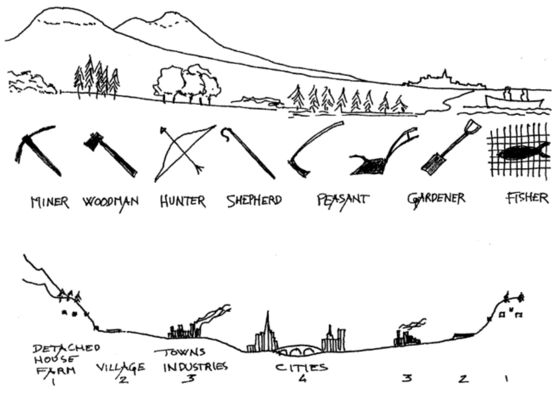
3.1. River Valleys as a Setting for Settlement

Access to water is essential to human settlement and therefore river valleys have often been favoured to establish settlements. Geddes’s river valley diagram, later reinterpreted by the CIAM (Congress International d’Architecture Moderne), illustrates the interrelationship between cities, rivers and the valley [28,29] (Figure 1). This is mentioned in many publications related to urbanism and takes many configurations [16,24,30,31]. Both Lynch and Bakema put a river at the centre of their generic illustrations of city evolution [26,29] (Figure 2). The settlements developed along and around rivers can be referred to as ‘river towns’ or ‘river cities’ [19] (p. 39).
Long before Cerda coined the term urbanism, ancient texts associate rivers with urban settlements (Figure 3). In ancient China, the description of the ideal location of cities trying to optimise the positive energy of nature includes a river as a southern boundary with the mountains protecting the north side [19,26,32]. The city of Babylon has the Euphrates running through the middle of the walled city. Roman settlements were positioned near rivers with their two main structural axes of circulation, cardo and decumanus, running parallel and perpendicular to the river corridor [33]. The Law of the Indies, put in place by the Spanish conquerors in South America during the 16th and 17th century also follows a reticular model orientated in relation to the adjacent river [34]. These early examples of towns and cities along rivers and early principles of urban forms influenced the discipline of urbanism [15,16]. Cerda refers to paths, rivers, valleys, coast lines and the sea as the main natural ways used as setting for ancient settlements and argues that they are at the origin of all ‘urbe’ (urban settlements) [35] (p. 114).
More generally, the favourable conditions for the setting of towns and cities are related to access to natural resources but also the need to provide a system of defence. There is also a need for trade, and this is linked to the ease of transport of goods and people [16,19,36,37]. Riverside locations contribute to all these requirements (Figure 4). In his pamphlet, The Evolution of Cities ([1895] 1995) Elise Reclus makes specific reference to river valleys as a prime location for cultivation and an ideal site for the first cities on ‘an artificial platform of beaten earth raised well above the level of inundation’ [36] (p. 5). The preferred locations being where torrents coming from the mountains widen and break in various branches or the confluence of rivers offering greater protection and wider choices for navigation. A deeper river and higher flow of water are often preferred with the settlements located on the higher, drier bank and avoiding the ‘oozy’, more floodable side [36] (p. 14). The easiest point of crossing the river is also a strategic setting for urban development of cities as argued by Poete in his Introduction à l’urbanisme (Introduction to urbanism) [38]. For him, the ideal setting should also include islands to facilitate the passage from one side of the riverbank to the other. The junction of two main circulation routes, road and river, is a favourable point for commercial activities and, therefore, successful settlements. Another favourable geographical characteristic is the point where the estuary becomes less influenced by the tide or where the river changes direction and forms an elbow [38] (p. 5).
The positive symbiosis of rivers and cities was compromised with the increase of urban populations and the requisite industrial activities. The quality of the water in the urban rivers became poorer to the point where they were considered as open sewers [3,5,39]. In Cerda’s theory of urbanism, rivers are discussed as a commodity for economic prosperity related to agriculture, commerce and industries and no longer an amenity for healthy living [35]. During the industrial revolution, the cities turned their back on their rivers or covered them. By the end of the 19th century, the water was no longer consumable and urbanists talked about the need for filtering and purification treatments [40]. Urban rivers were then often hidden, enclosed by buildings or buried, and their picturesqueness and natural ecology was destroyed [39]. The subsequent decline of industries in Europe from the 1980s onwards has offered an opportunity to reclaim riverside areas as an attractive setting for new developments.

3.2. Rivers in Cities: Functionality and Aesthetics

Function and aesthetics are two drivers of design related practices including urbanism [41,42]. In the case of riverside locations, the functionalists see rivers mainly as providing a free supply of water, a source of energy through the use of waterpower and major transport arteries [43]. Robinson also acknowledges that rivers are essential to supply power and for navigation, but he also considers the attractiveness of rivers referring to their ‘picturesqueness’ [37] (p. 5). This dual consideration provides the framework to identify types and characteristics of riverside urban landscapes in the literature.

3.2.1. Functionality: Highway for Navigation and Waterpower

Navigation is a main function of those rivers deep enough to allow boats to circulate and with a regular water flow. This is not specific to former industrial cities, however the transport of goods and people intensified with the development of the industrial activities and the increase in urban population [44]. This, and the added potential of generating power by canalising and controlling water flow, make riverside locations ideal for industries [3,37,39]. In many of the texts consulted, the cities illustrated—existing or utopian—include large industrial areas along the river that are often downstream to optimise transport connections and avoid spoiling the city centre with pollution, as in Tony Garnier’s plan for the industrial city [45] or Tunnard’s City of Man [46] (Figure 5). The concentration of industrial activities along rivers created specific urban river landscapes with the water being canalised and controlled to serve man-made functions. Robinson positively describes river embankments dedicated to the arrival of goods and people as follows: ‘On either side, throughout its city course, the river is lined with imposing walls of masonry. Large stone platforms, connected with the street at intervals by steps and inclined roadways, serve the needs of commerce; and above, the quays, bordered on the river side by a handsome coping, afford a favourite promenade’ [37] (p. 11). This can be illustrated with typical sections of quays and embankments representative of the configuration (with variations) of many ‘river city’ centres (Figure 6).
When rivers are not, or only partly, navigable, engineering modifications were included to harness waterpower with runs, reservoirs, dams and weirs. These man-made structures have irrevocably modified the river corridors and have dramatically affected the natural habitat and appearance of urban rivers [48]. These functional interventions in river corridors create a unique industrial river landscape heritage [49]. However once waterpower was replaced by more reliable sources of energy, the river was mainly used to extract water for cooling purposes and became the outlet for wastewater, creating dead, unsightly and dangerous water bodies, often hidden and ignored [40]. As early as 1953, Forshaw and Abercombie proposed reclaiming former industrial riverside areas for mixed used developments including residential areas with open space infrastructure by regrouping industrial activities and freeing some of the land along the water [50] (Figure 7).

3.2.2. Aesthetics: Picturesqueness

Robinson sees ‘picturesqueness’ as an inherent value to the functionality of rivers for urban development and stresses the attractiveness of riverside locations (1901). He talks about ‘the value of vista in water-front treatment’, arguing that riverfront locations provide a more monumental setting for buildings [47]. Saarinen celebrates the reflections of the surrounding urban environment in the water: ‘reflecting parks and buildings in the watery mirror’ [51] (p. 315). The picturesque movement championed by Sitte and Unwin considers the planning of cities as an art form and promotes the use of ‘natural’ and irregular lines. They believe that urbanism practices should be inspired by medieval towns and respond to the characteristics of the site and the needs of the users rather than imposing contrived geometrical shapes. They consider the river corridor as instrumental in the incremental development of the urban environment, arguing that it should follow the linear flow of the water and provide perpendicular access and vistas to bridges [52,53]. Sitte celebrates water in cities as an essential element to break the monotony of the built environment and argues that remarkable cities such as Paris, Budapest or Cologne cannot be dissociated from their respective rivers [52] (p. 168). Lanchester mentions the importance of preserving ‘the characteristic qualities of waterside scenery,’ [54] (p. 347) while Saarinen refers to the Isar in Munich as a binding element in the urban realm [50] (p. 315). For Cullen, urban rivers should be an opportunity to create a unique living environment. He talks about ‘the creation of an atmosphere of ornamental gaiety, a distinctive riverside urbanity’ [55] (p. 241). Cullen’s contrasting urban river landscape proposals along the Thames depict a vibrant social life including ‘contact with the river, spaces for boats, watermen; it implies the possibility of eating, drinking and smoking, talking within the frame of this atmosphere—the social life’ [55] (p. 236) (Figure 8). The sections below categorise elements in the urban fabric, which might contribute to the ‘riverside urbanity’ that Cullen mentioned, at different scales of intervention, from strategies to details.

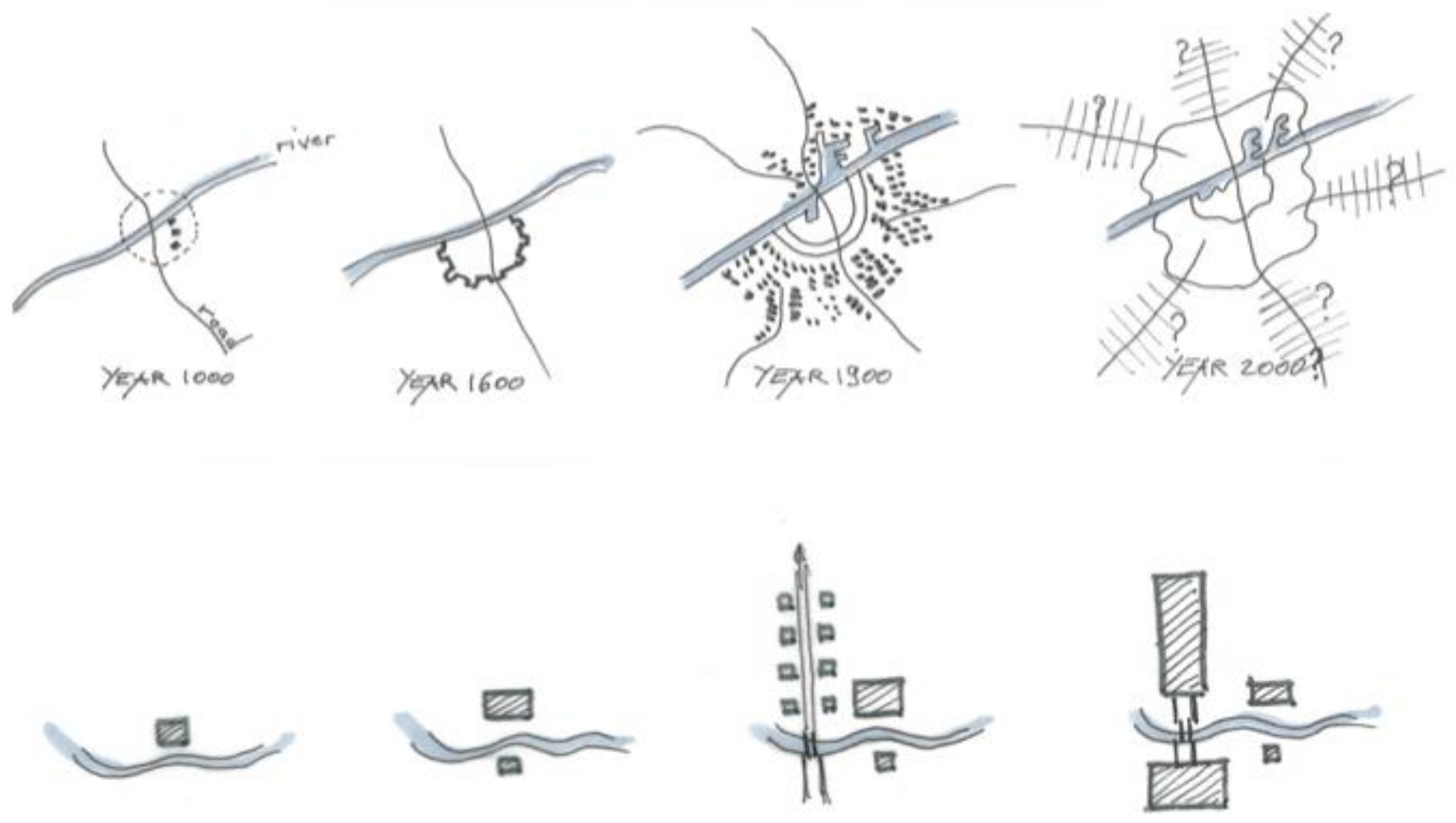
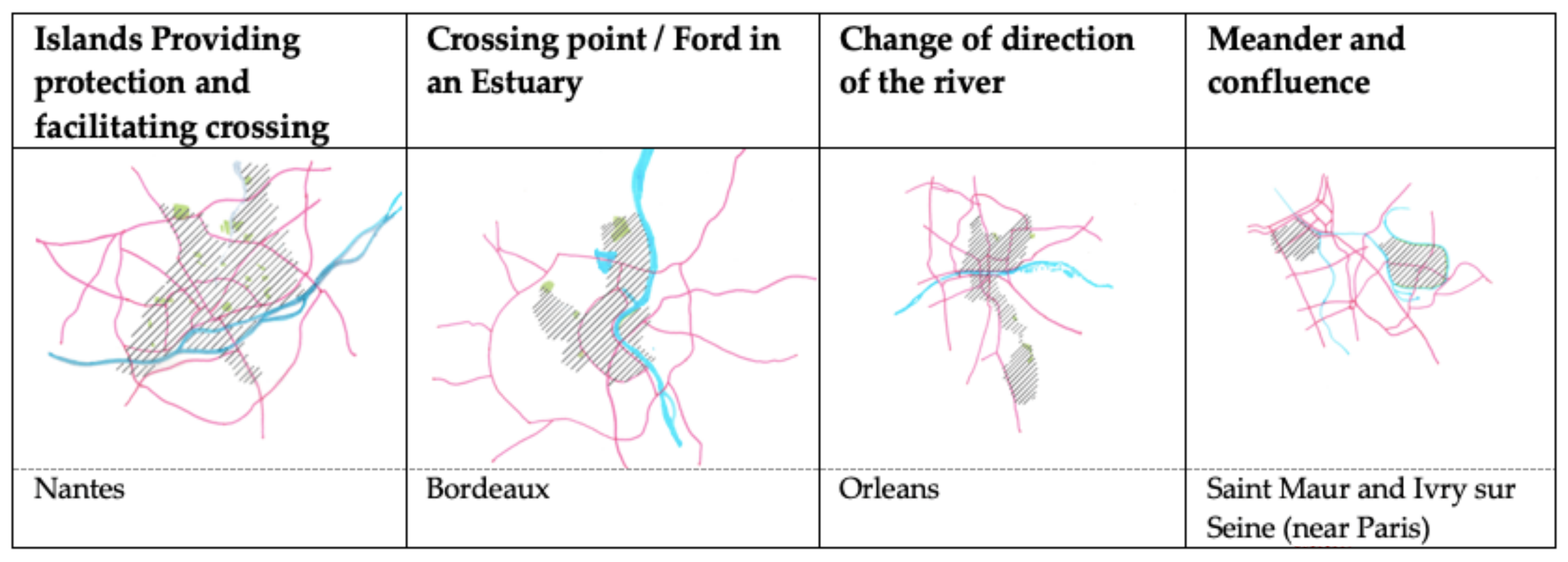
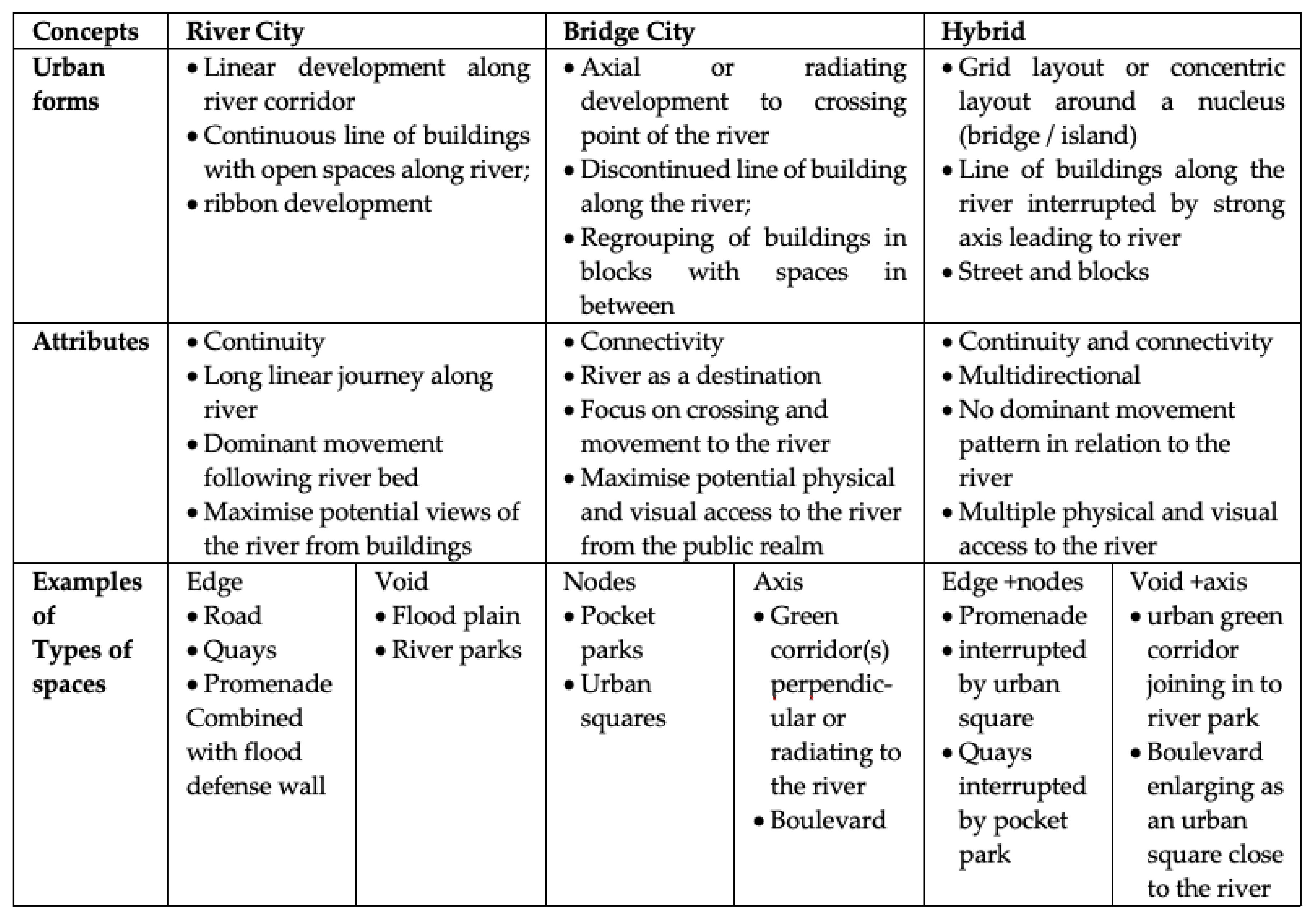
3.3. City Scale Strategies Realted to Urban Rivers

Rivers are part of the natural geographical constraints of a place and form a primary infrastructure for urban developments. Alexander stresses the importance of treating natural bodies of water in urban areas with respect, advocating the need to ‘always preserve a belt of common land, immediately beside the water’ [27] (p. 137). River corridors cannot be considered in isolation, they have an intimate relationship with the surrounding urban forms and influence urban development patterns [39,56,57]. They are associated with the genesis and evolution of the ‘macroforms’ of cities, including the main transport axes and open space infrastructure [58] (Figure 9). Rivers form strong lines and have been referred to as ‘undulating linear bands of public space between areas of streets and development blocks’: a boundary between two different phases of development [55] (p. 256). They are also referred to as an edge [25] or ‘urban void’ type of space [59] (p. 105); ‘the last remaining paths where man may re-establish his right for access and enjoyment’ [39] (p. 20).

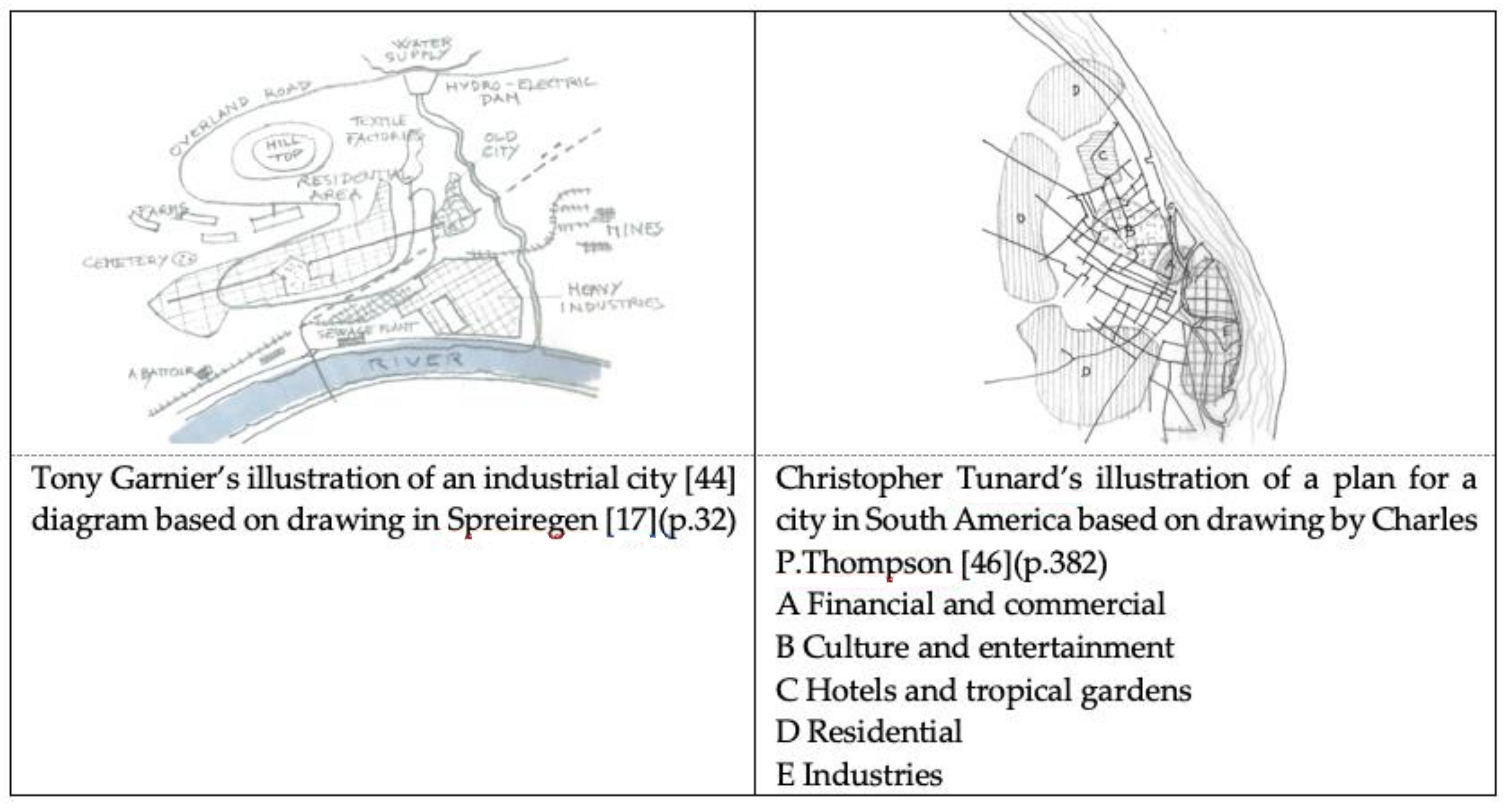
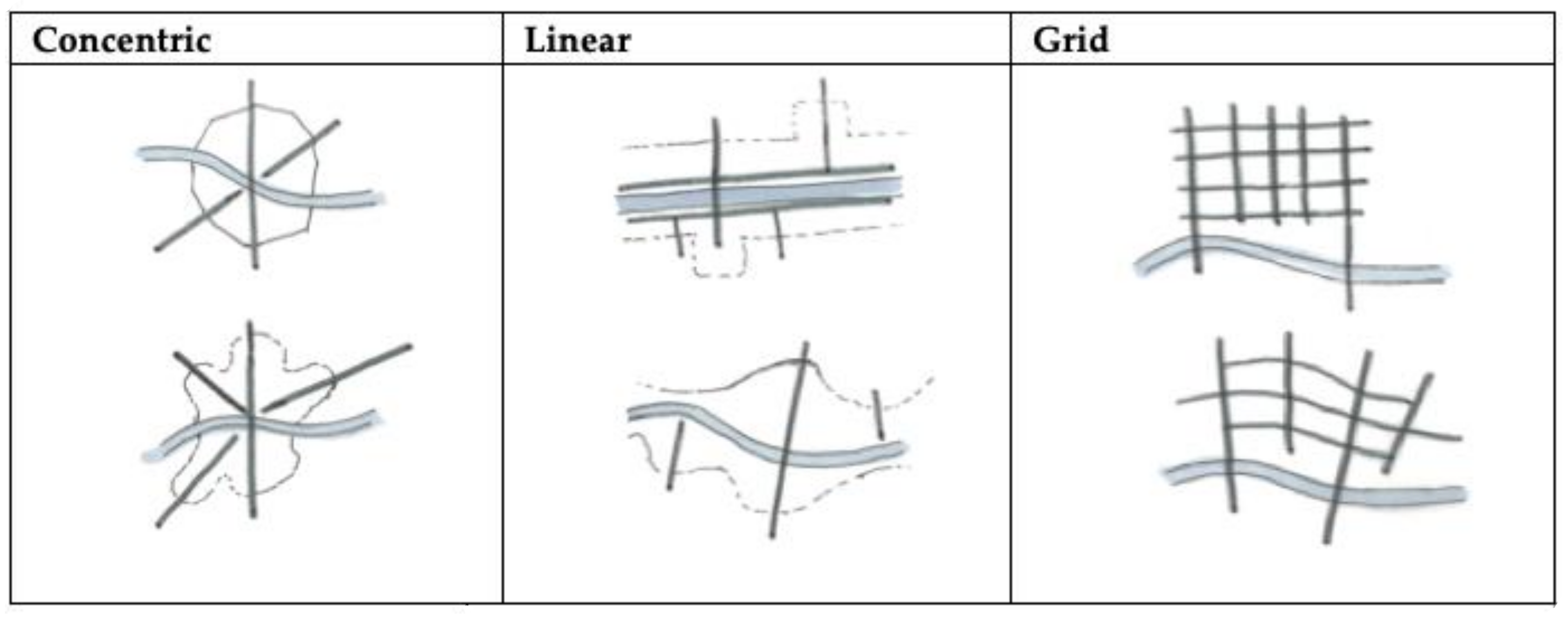
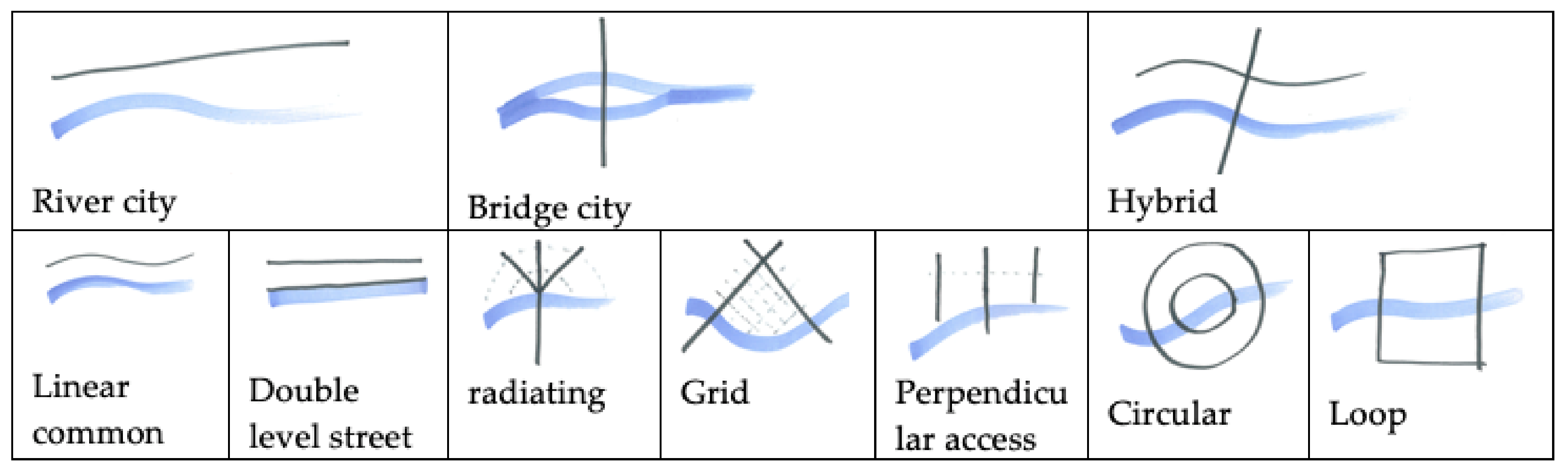
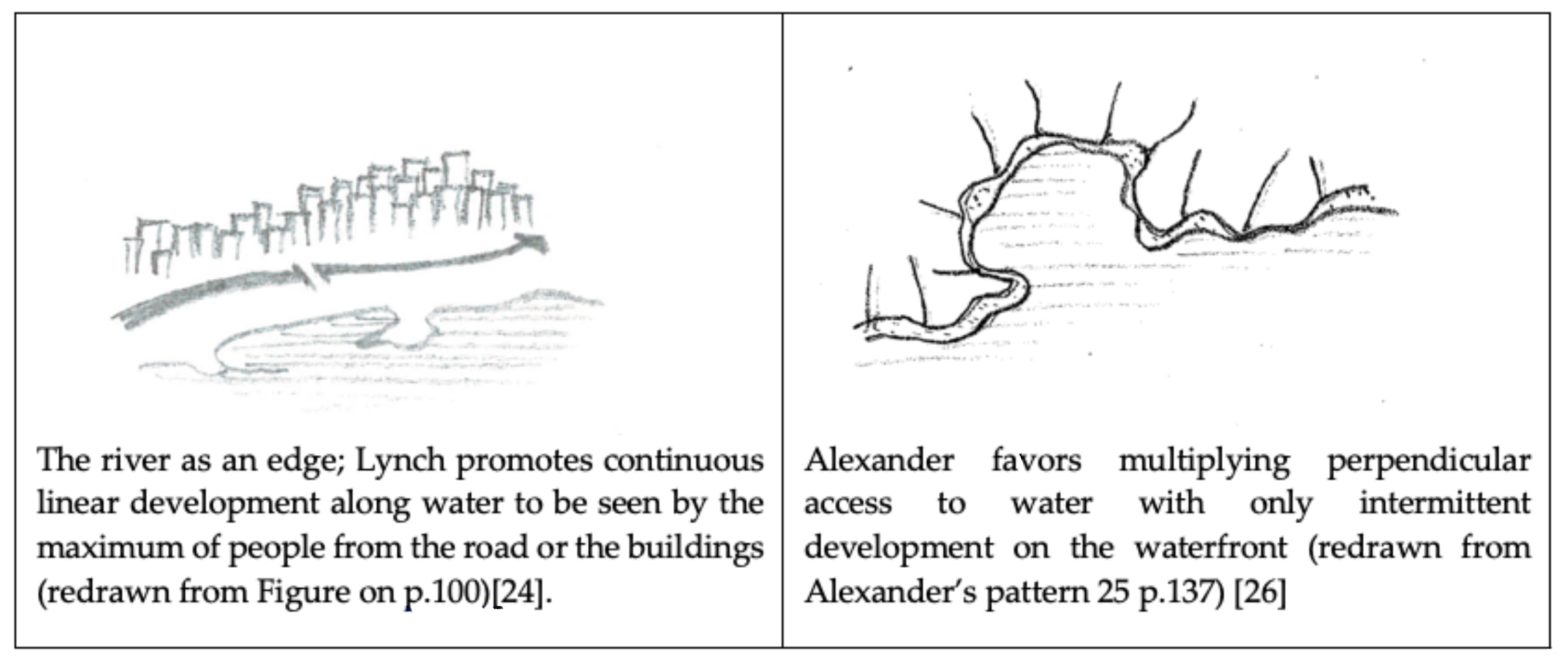
3.3.1. Urban Layout and Rivers

The configuration of the river along which the city developed, has an impact on the character of the settlement. For example, Poete describes a meander as a ‘passive form’ and a destination in contrast to a curvilinear riverbed, which is a more ‘active’ form encouraging a more dynamic circulation pattern [38] (pp. 85–86). Lavedan proposes two types of relationships between urban layout and rivers [60]. The first are “river cities”, which are urban settlements where the river has a direct influence on urban development with the layout following the river line. The second are ‘bridge cities’ where the urban settlement is linked to an important crossing point with a street pattern dominated by an axis perpendicular to the river [60] (pp. 39–41). The river city is the desired urban layout when the river is too wide to cross easily while the bridge city is selected when a narrow point of the river makes it easy to cross. The river city can be associated with the linear city type as it has similarities with linear city development along important routes [26,35,46,58]. In a bridge city, the initial bridge becomes the anchor point, fixing future urban layout and forms. This model offers the most variations with the street network developing different patterns. This is linked to radiating layouts converging to the crossing point and also to the orthogonal and rectilinear layouts also referred to as grid layouts [25,58]. A hybrid type might develop when the centre of the development is related to multiple routes converging to the settlement, the layout of the city then develops in a concentric pattern, which might also be referred to as loop development around a nucleus in the form of a bridge or island. Figure 10 attempts to present variations of types of circulation patterns and urban layouts related to river cities and bridge cities illustrated through models of city forms described in the literature and illustrated in drawings and models [17,19,26,33,46,58,61,62].

3.3.2. Blue and Green Infrastructure/Park System

As mentioned above, rivers form a linear barrier if they are wide or constitute a void in the urban layout when both banks are developed. Whatever the configuration of the built form, rivers are an integral part of the urban open space network. There is consensus that low land and floodplains should remain free of buildings and hard surfaces and should be dedicated to open spaces and parks [46,47,54,63]. The river edge should be accessible at water level, higher level or both to provide inviting and comfortable linear open spaces for circulation and leisure activities [26,27,37,64]. Olmsted, the father of the park system movement, argued that land adjacent to rivers should be protected and managed by public bodies. A public park system along rivers in urban environment would address sanitary issues by providing air and sunlight while also mitigating flood risks [54] (p. 343). Positioning parks along river corridors would also create an attractive setting for the development of adjacent land. Forestier, in the context of the French legal planning system, advocates the reclamation by compulsory purchase of land along urban rivers to create public parks [63]. The idea of publicness and common land with free public access and use along rivers is a recurrent theme in the literature [27,47,55,64,65,66]. Cullen goes as far as proposing that the Thames Valley becomes a ‘linear National Park’ [55] (p. 241). There are multiple variations in the configuration of blue and green infrastructure and park systems in riverside locations. These different approaches can be associated to Lavedan’s ‘river city’ and ‘bridge city’ concepts mentioned earlier, but also to the contrasting generic urban waterfront patterns proposed by Lynch [25] and Alexander [27] (Figure 11).
Lynch considers the river as an edge linked to movement and built forms following the water line. By contrast, Alexander promotes access to the water at right angles to the river line with common land acting as a buffer zone between the dense urban environment and the water. Lynch puts the emphasis on the positive visual impact of water suggesting that the riverside should be seen by the many and therefore proposes a road following the line of the water with a continuous line of buildings on the waterfront [25]. This concept has similarities with Milutin’s proposal for Stalingrad, where the various elements of the cities are organised in successive lines following the path of the water, but Milutin pushes the road behind the line of buildings bordering the open space along the water [67]. On the other hand, Alexander advises that ‘buildings to the water’s edge should only occur at infrequent intervals,’ and that roads should be kept at least a mile away from the water [27] (p. 137). This principle was also adopted by Cullen, who put forward a strong argument to prohibit ‘ribbon’ development along rivers [55]. Le Corbusier and Bacon also favour a non-continuous line of development along the river. They propose a series of public planted open spaces perpendicular to the river line enabling views and access to the water. These were to be manifest in the alignment of bridges. However, they also put forward the need for continuous common amenity spaces following the water’s edge in order to address the risks of flooding [24,68].
The risk of flooding is key to design considerations of riverside locations. Cerda pointed out the destructive impact of big flood events in river valleys [35]. Tunnard argues that building on floodplains was a costly mistake requiring huge investments to make them safe [46] and McHarg recommends that floodable plains should be excluded from consideration for development [69]. Therefore, the edge of the river in an urban context needs to be considered carefully. The two contrasting approaches to river edges are ‘soft ’or ‘hard’. The ‘soft edge’ approach is favoured by many advising to reserve a strip of land along the water to accommodate the unpredictable fluctuation of the water level and provide open air facilities [27,54]. However, in former industrial cities and in dense city centre locations where the river flow is controlled to mitigate flooding, provide power and facilitate navigation, engineered ‘autocratic irrigation systems’ dominate [70] (p. 30). The river is then canalised between hard edges. These consist of quays and embankments for the circulation and loading of goods or passengers with no space for large linear continuous ‘river parks’ but often offering a promenade at the upper and/or lower level as illustrated in Figure 6. Flood defence walls keep water within the artificial river channel. Examples of sections of soft and hard river edges are illustrated in Figure 12.

3.4. Open Spaces along the River: Design Strategies

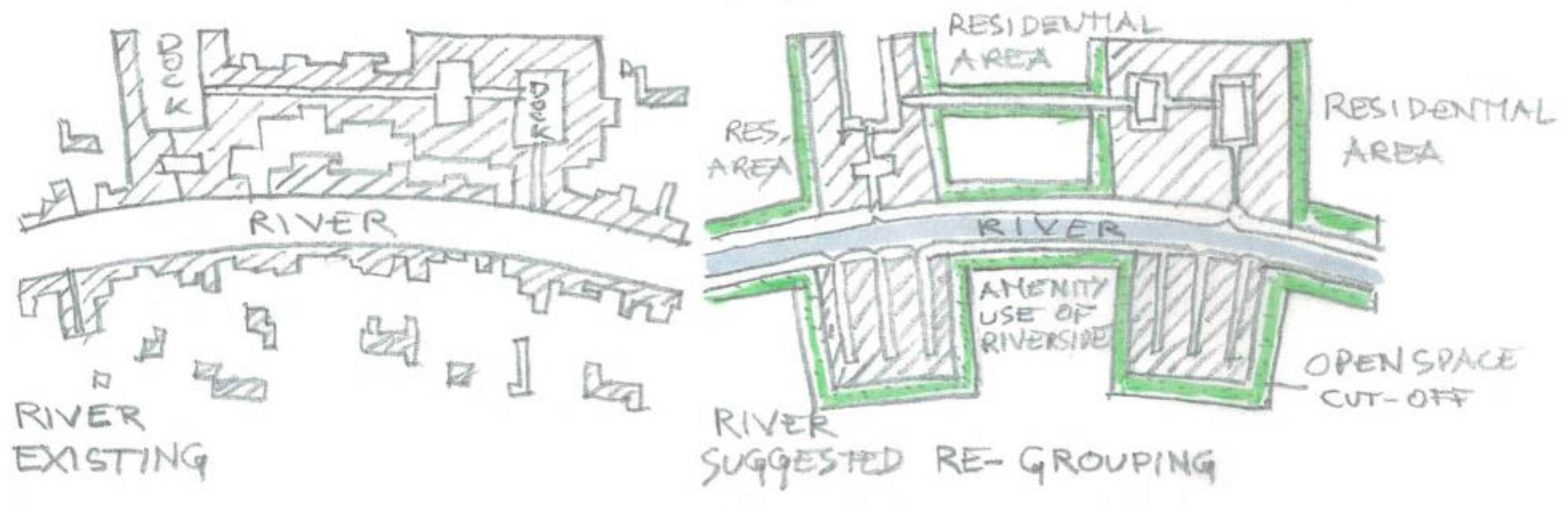
3.4.1. Linear Open Spaces

Trancik provides a good summary of the generic characteristics of linear open spaces along rivers. “[…] commonly related to major water features such as rivers […] The formal and informal greenways slice through districts, create edges, and link places […] Linear open spaces generally offer continuous greenery in contrast to the regular grid of urban streets” [59] (pp. 105–106). This approach can be associated with the concept of the ‘River city’ with the line of water being the principal determinant to the urban layout. The types and functions of these linear open spaces mentioned in the literature vary. Lynch, following on with the ‘edge’ concept, coined the term of ‘river parks’, which could have different characters related to the width of the linear open space. If large enough, it could contain a major road (Rock Creek Park, Washington, DC, USA), or if narrow, it could take the form of a pedestrianised promenade (Paseo del Rio, San Antonio, TX, USA) [26] (p. 437). Alexander suggests that the paths should be accommodated along streams, which could act as barriers to developments with only infrequent crossings. The main design principle related to the concept of linear ‘River parks’ is the need for continuity in movement and in the open spaces network. As mentioned above, the width might vary facilitating different types of uses [27].
On a large planning scale, Hillberseimer, in his belt of city ‘aggregates’ along a river, proposes a forested area along the river, ‘forming a natural recreation area for the settlements of the main belt’ [69] (p. 264). At the city scale, Richard Neutra, in his futuristic ‘rush city’, proposes a large linear ‘river park’ to accommodate flood risk bordered by low density residential development in the form of houses with large gardens before proposing dense urban forms with high rise buildings (Figure 11). Mawson favours a more ornate approach in the form of public gardens while Wright’s proposals for his Broadacre city include sports fields, music gardens, parks and market centres [65,66].

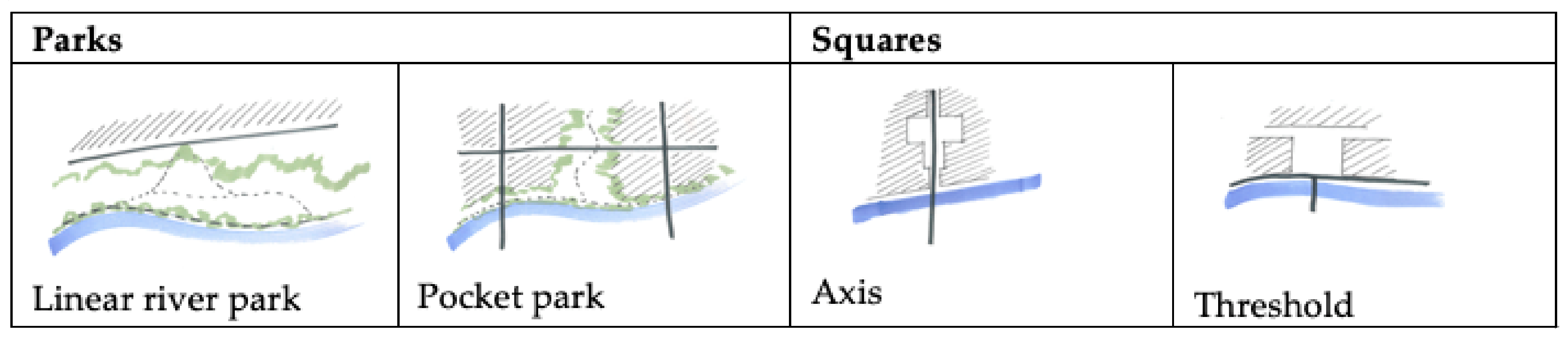
3.4.2. Urban Squares, Green Axis and Pocket Parks

Open space networks positioned at a right angle to, or radiating from, the line of the water can be associated with the ‘bridge city’ concept, with urban layouts celebrating the crossing of the river. These types of layouts are often associated with urban squares acting as a threshold before entering the narrow crossing structure [54,60,61]. The use of urban squares as a point of arrival from the bridge, optimising views of the river and a strong node of circulation, is presented as good practice in contemporary urban design manuals [71].
Other urban layouts privilege the rectilinear approach with a gridiron pattern and cellular growth. Bacon provides a good example of this type of layout for Savanah. The numerous axes going to and from the river are interspersed with pocket parks [68] (pp. 220–221). Other urban proposals focus on one main axis in the line of a main bridge. The interlocking series of open spaces along one important axis of circulation structured the urban layout, offering good views, breathing spaces and a legible access to the river. Le Corbusier’s proposal to rebuild a nameless city bombed during the war is a good example of this approach. The ‘heart of the city’ lay along the alignment of the main bridge and has the form of a civic square with all the necessary public facilities [24] (p. 62). For him, Piazza San Marco in Venice is the best example of an urban square providing a convincing threshold between water and city. In contrast, Sitte uses the Zwinger in Dresden to illustrate a plaza between monumental buildings forming an axis running to the river [52] (p. 116). Another option for open spaces network along rivers is the intermittent development freeing spaces for pocket parks along the water’s edge offering visual amenity, fresh air, regular access to the river edge and recreational opportunities for the surrounding mixed-use developments and residential areas. This is well-illustrated by Forshaw and Abercombie’s proposal of ‘re-grouping’ mentioned before (Figure 7) [50] (p. 211) or Hilberseimer’s ‘belt of city aggregates’ [69] (p. 264). The various types of open spaces on riverside locations are summarised and illustrated in Figure 13.

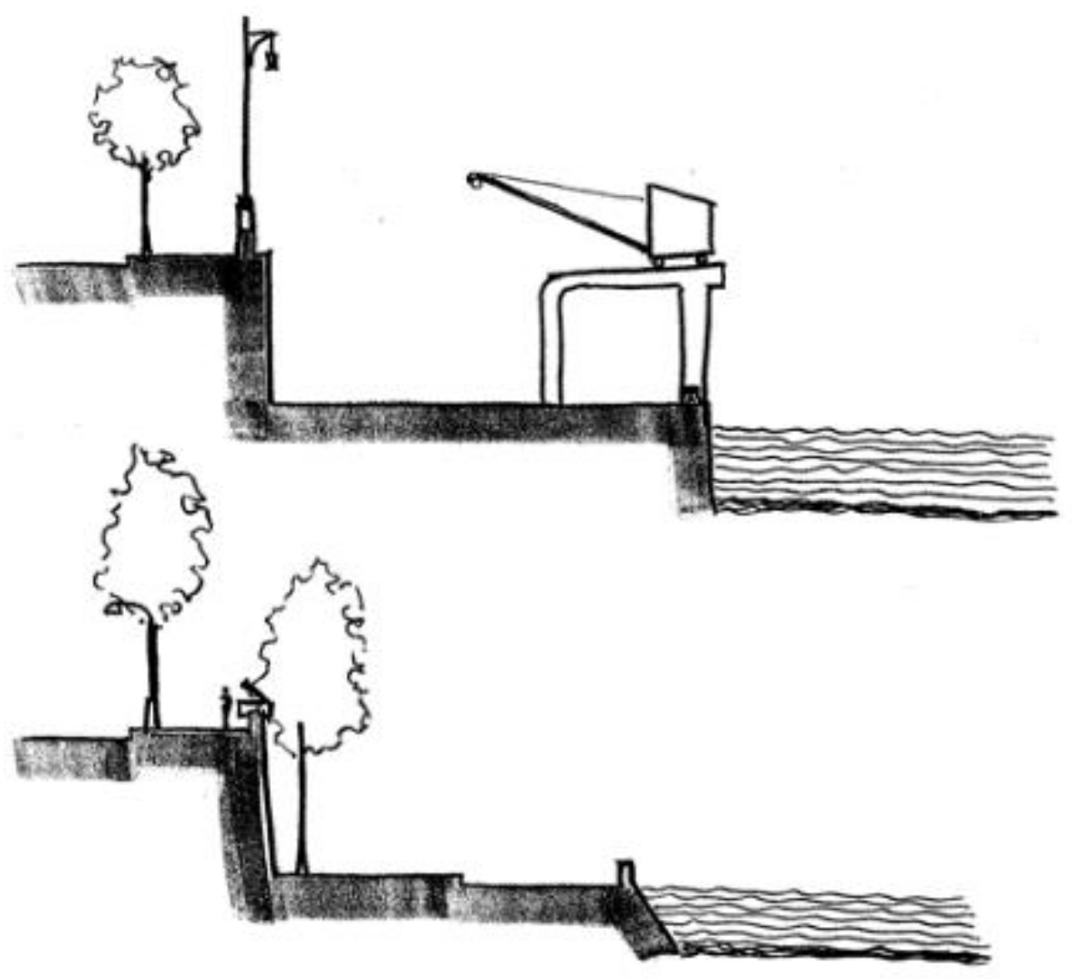
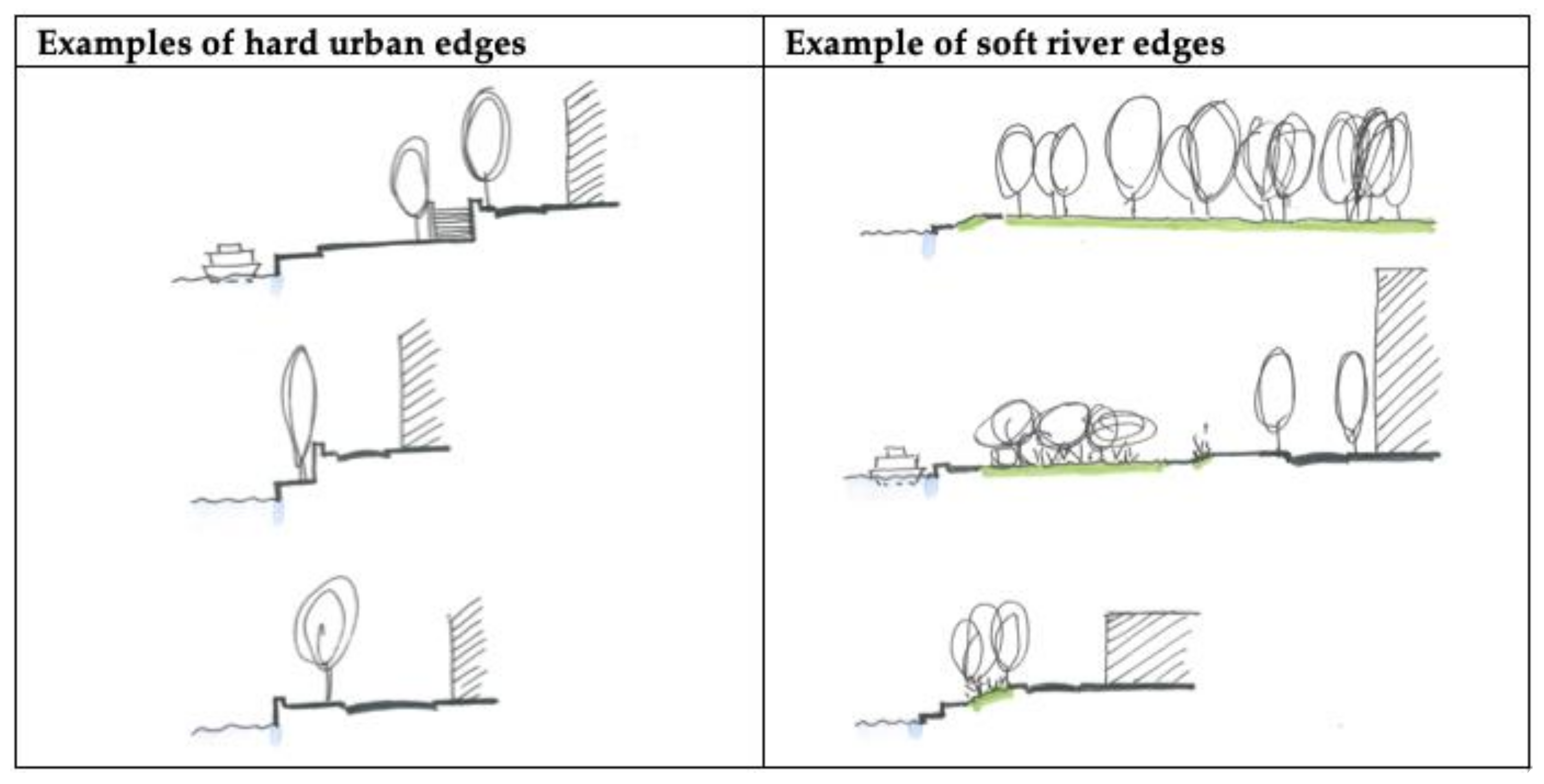
3.4.3. Further Detailed Design Considerations

The need to provide landing places along the water is mentioned in several sources, either as a monumental hard landscape intervention or in the form of floating piers [37,52]. Considering that the texts reviewed date from after the industrial revolution, references discussing a more direct relationship of people and water in the form of swimming are rare. However, in Le Corbusier’s drawing for a ‘functional settlement’, he proposes to dam the river ‘to create a lake close to the city centre offering opportunities for swimming and skating in winter’ [24] (p. 88).
In the literature consulted there is an emphasis on tree planting on riverside locations. The character of the tree planting typologies varies. Hilberseimer’s ‘belt of city aggregates’ include a forested area along the river and in between urban forms [70]. This has similarities with the large flood plain proposed by Neutra in his ‘rush city’ [72]. However, in this case there is no specific reference to trees. Mawson refers to the ‘river avenue’ ‘to give added beauty to the river banks by the formation into a public garden,’ [65] (p. 294) while Robinson celebrates the Victoria Embankment in London for ‘its gardens and rows of trees providing a park like appearance that bestows an almost holiday character’ [37] (p. 11).

4. Discussion

This review demonstrates that rivers are key to the location of towns and cities and to urban development. Reviewing key texts on urbanism, with a focus on urban rivers, provides a new insight in planning and design guidance for riverside developments. The references selected are extensive and enable the identification of relevant planning and design ideas. They are principles and strategies that relate specifically to urban riverside layouts, which can be summarised through their types of approaches and interventions. This can inform future riverside development, contributing to the potentially unique character defined as ‘riverside urbanity’. The aim of the review is to inform conceptual ideas, not specific design interventions, therefore, the summary table below focuses on the dominant types of interventions with dominant resulting types of open spaces and green infrastructure. Variations on these types are multiple and would relate to the specificity of the place (Figure 14).
These transferable principles and types of interventions provide a theoretical framework to inform planning and design decisions. The ‘river city’ and ‘bridge city’ concepts provide a clear distinction between the two types of relationship between the river, the surrounding infrastructure and adjacent urban forms. The celebration of the linearity of the river, or the emphasis on the crossing point. This can contribute to a better understanding of the unique character of a riverside location and its surrounding to inform new urban forms. The ‘river city’ type puts more emphasis on the water edge and on promoting continuous built forms along the river. The ‘bridge city’ types emphasise the importance of getting to the river with multiple points of access in between blocks of buildings. This approach moves away from the idea of the river corridor and favours a wider impact of the river on the surrounding urban environment. In the texts consulted, the references to urban rivers are closely associated with green and blue infrastructure. The principles identified in the study can inform the choice of types of open spaces along rivers. The consensus is that ’riverside urbanity’ implies a physical and visual connection with the river accessible to all with reference to a ‘common land’ along the river. The ‘soft edge’ approach favours the idea of ‘river parks’: a continuous open space also refered to as ‘void’ in the dense urban fabric following the river corridor. This implies preserving or reclaiming the natural flood plain and pushing the built forms away from the river. The ‘hard edge’ approach is more common in former industrial cities where the buildings are close to the river. Quays, embankments and promenades can provide the linear continuity of open spaces along the river, but it remains narrow and dominated by hard surfaces. In this case, new developments offer an opportunity to create open spaces in the form of ‘pocket parks’ by regrouping new buildings. In compact cities with high density of buildings, these pocket-size open spaces might take the form of urban squares close to the river or linear axis through the urban fabric, leading to the river. The link between rivers and open spaces is essential in addressing flood prevention and contributes to the creation of settings for high quality new housing developments.
The discipline of urbanism was born from the necessity to provide more formal organisation to ensure functional and comfortable living conditions in rapidly developing cities. Faced with the current rapid increase of urban population and contemporary challenges related to the sustainable living agenda and climate change, urban planning and design can only benefit from underpinning principles to inform practices. The concepts and principles identified and illustrated in this paper derived from the literature related to urbanism can provide some grounding to inform future urban strategies for the regeneration of former industrial sites in riverside locations. Further research might include the exploration of the potential characteristics of the ‘common land’ along river or linear riverside open spaces and surrounding urban forms. The identification of key indicators to assess the performance of urban forms and open spaces strategy in riverside locations to integrate water flow as part of the urban design dynamics. This will enable the analysis of existing projects by illustrating good practices and enabling a refinement and development of the key planning and design principles identified in this paper.

Funding

This research received no external funding.

Institutional Review Board Statement

Not applicable.

Informed Consent Statement

Not applicable.

Data Availability Statement

Not applicable.

Acknowledgments

I would like to thank Nicola Dempsey for her continual support, encouragement and stimulating discussions. I also wish to thank Jan Woudstra for proofreading the text.

Conflicts of Interest

The authors declare no conflict of interest.

References

  1. Böck, K.; Polt, R.; Schülting, L. Ecosystem Services in River Landscapes. In Riverine Ecosystem Management. Aquatic Ecology Series; Schmutz, S., Sendzimir, J., Eds.; Springer: Cham, Switzerland, 2018; Volume 8. [Google Scholar] [CrossRef]
  2. Marshall, R. Waterfronts in Post Industrial Cities; Spon Press: London, UK, 2001. [Google Scholar]
  3. Petts, G.; Heathcote, J.; Martin, D. Urban Rivers Our Inheritance and Future; IWA Publishing: London, UK, 2002. [Google Scholar]
  4. Kibel, P.S. Rivertown; Rethinking Urban Rivers; The MIT Press: London, UK, 2007. [Google Scholar]
  5. Everard, M.; Moggridge, H. Rediscovering the Value of Urban Rivers. Urban Ecosyst. 2012, 15, 293–314. [Google Scholar] [CrossRef]
  6. Cudworth, E. Environment and Society; Routledge: London, UK, 2003. [Google Scholar]
  7. Romain, F. La Construction des Paysages Fluviaux Urbains au Nord de la Méditerranée. Intérêt d’une Démarche Comparative. Proj. Paysage 2009, 2009, 15. [Google Scholar]
  8. Davenport, A.J.; Gurnell, A.M.; Armitage, P.D. Habitat survey and classification of urban rivers. River Res. Appl. 2004, 20, 687–704. [Google Scholar] [CrossRef]
  9. Gurnell, A.; Lee, M.; Souch, C. Urban rivers: Hydrology, geomorphology, ecology and opportunities for change. Geogr. Compass 2007, 1, 1118–1137. [Google Scholar] [CrossRef]
  10. Holzer, C.T.; Hundt, T.; Lüke, C.; Hamm, O.G. Riverscapes; Designing Urban Embankment; Birkhauser: Basel, Switzerland, 2008. [Google Scholar]
  11. Rotherham, I. The river Don: A linear urban wildscape. In Urban Wildscapes; Jorgensen, A., Keenan, R., Eds.; Taylor Francis: London, UK, 2011; pp. 133–140. [Google Scholar]
  12. Prominski, M.A.; Stokman, A.; Keller, S.; Stimberg, D.; Veormanek, H. River Space Design; Planning Strategies, Methods and Projects for Urban Rivers; Birkhauser: Basel, Switzerland, 2012. [Google Scholar]
  13. Milburn, L.-A.S.; Brown, R.D. The relationship between research and design in landscape architecture. Landsc. Urban Plan. 2003, 64, 47–66. [Google Scholar] [CrossRef] [Green Version]
  14. Choay, F. L’Urbanisme, Utopies et Realites: Une Anthology; Editions du Seuil: Paris, France, 1965. [Google Scholar]
  15. Choay, F. The Modern City: Planning in the 19th Century; George Brazillier: New York, NY, USA, 1969. [Google Scholar]
  16. Lavedan, P. Geographie des Villes; Librairie Gallimard: Paris, France, 1936. [Google Scholar]
  17. Spreiregen, P.D. The Architecture of Town and Cities; Mc Graw Hill Book Company: New York, NY, USA, 1965. [Google Scholar]
  18. Hall, P. Cities of Tomorrow; Blackwell: London, UK, 1988. [Google Scholar]
  19. Kostof, S. The City Shaped: Urban Patterns and Meanings Through History; Thames and Hudson: London, UK, 1991. [Google Scholar]
  20. Shane, D.G. Recombinent Urbanism; Conceptual Modelling in Architecture, Urban Design and City Theory; John Wiley and Sons Ltd.: Chichester, UK, 2005. [Google Scholar]
  21. Cuthbert, A. Understanding Cities; Methods in Urban Design; Taylor and Francis: London, UK, 2011. [Google Scholar]
  22. Wade, G. Dream Cities: Seven Urban Ideas that Shape the World; Harper Pernennial: New York, NY, USA, 2016. [Google Scholar]
  23. Pallasmaa, J. The Thinking Hand; John Whiley and Sons: Chichester, UK, 2009. [Google Scholar]
  24. Corbusier, L. Maniere de Penser l’Urbanisme; Architecture d’Aujourd’hui: Boulogne-sur Seine, France, 1946. [Google Scholar]
  25. Lynch, K. Image of the City; The MIT Press: Cambridge, MA, USA, 1960. [Google Scholar]
  26. Lynch, K. A Theory of Good City Form; The MIT Press: Cambridge, MA, USA, 1981. [Google Scholar]
  27. Alexander, C.; Ishikawa, S.; Silverstein, M. A Pattern Language; Towns-Buildings-Construction; Oxford University Press: New York, NY, USA, 1977. [Google Scholar]
  28. Geddes, P. Cities in Evolution; An Introduction to the Town Planning Movement and to the Study of Civics; Williams & Norgate: London, UK, 1915. [Google Scholar]
  29. Smithson, A. Team 10 Primer; Studio Vista: London, UK, 1968. [Google Scholar]
  30. Rasmussen, S.E. The Unique City; The MIT Press: Cambridge, MA, USA, 1952. [Google Scholar]
  31. Morris, A.E.J. History of Urban Form Before the Industrial Revolution; Routledge: London, UK, 1979. [Google Scholar]
  32. Schinz, A. The Magic Square: Cities in Ancient China; Axel Menges: Stuttgart, Germany, 1996. [Google Scholar]
  33. Benevolo, L. The History of the City; The MIT Press: Cambridge, MA, USA, 1980. [Google Scholar]
  34. Rodriguez, R. The foundational process of cities in Spanish America: The law of Indies as planning tool for urbanization in early colonial towns in Venezuela. Focus 2005, 2, 47–57. [Google Scholar] [CrossRef] [Green Version]
  35. Cerda, A. Teoria General de Urbanizacion; La Theorie Generale de l’Urbanisme; Les Editions de l’Imprimeur: Paris, France, 2005. [Google Scholar]
  36. Reclus, E. The Evolution of Cities; Jura Media: Sidney, Australia, 1995. [Google Scholar]
  37. Robinson, C.M. The Improvement of Towns and Cities or The Practical Basis of Civic Aesthetics; G.P. Putnam’s Sons: New York, NY, USA, 1901. [Google Scholar]
  38. Poete, M. Introduction a l’Urbanisme; L’Evolution des Villes; Boivin & Cie: Paris, France, 1929. [Google Scholar]
  39. Mann, R. Rivers in the City; David and Charles: Newton Abbot, UK, 1972. [Google Scholar]
  40. Richardson, B. Hygiea; A City of Health; Book Jungle: London, UK, 2009. [Google Scholar]
  41. Appleton, J. The Experience of Landscape; Wiley: London, UK, 1975. [Google Scholar]
  42. Bourassa, S.C. Toward a theory of landscape aesthetics. Landsc. Urban Plan. 1988, 15, 241–252. [Google Scholar] [CrossRef]
  43. Lewis, M.; Haupt, C.E. Planning the site for a city. Eng. Mag. 1895, 8, 626–637. [Google Scholar]
  44. Bogart, D. The transport revolution in industrializing Britain. In The Cambridge Economic History of Modern Britain: Volume I, 1700–1870, 4th ed.; Floud, R., Humphries, J., Johnson, P., Eds.; Cambridge University Press: Cambridge, UK, 2014; pp. 53–88. [Google Scholar]
  45. Garnier, T. Une Cite Industrielle, Etude Pour la Construction des Villes; Ch Massin &Co: Paris, France, 1917. [Google Scholar]
  46. Tunnard, C. The City of Man; Charles Scribner’s Sons: New York, NY, USA, 1953. [Google Scholar]
  47. Robinson, C.M. City Planning with Special Reference to the Planning of Streets and Lots; G.P.Putnam’s Sons: New York, NY, USA, 1916. [Google Scholar]
  48. Findlay, S.; Taylor, M. Why rehabilitate urban river systems? Area 2006, 38, 312–325. Available online: http://www.jstor.org.sheffield.idm.oclc.org/stable/20004548 (accessed on 17 June 2021). [CrossRef]
  49. Howard, A.J.; Coulthard, T.J.; Knight, D. The potential impact of green agendas on historic river landscapes: Numerical modelling of multiple weir removal in the Derwent Valley Mills world heritage site, UK. Geomorphology 2017, 293, 37–52. [Google Scholar] [CrossRef] [Green Version]
  50. Gibberd, F. Town Design; The Architectural Press: London, UK, 1953. [Google Scholar]
  51. Saarinen, E. The City: Its Gowth, Its Decay, Its Future; The MIT Press: Cambridge, MA, USA, 1943. [Google Scholar]
  52. Sitte, C. City Planning According to Artistic Principles; Random House: New York, NY, USA, 1965. [Google Scholar]
  53. Unwin, R. Town Planning in Practice; An Introduction to the Art of Designing Cities and Suburbia; T. Fisher Unwin.: London, UK, 1909. [Google Scholar]
  54. Lanchester, H.V. Park Systems for Great Cities. Builder 1908, 95, 343–348. [Google Scholar]
  55. Cullen, G. The Concise Townscape; The Architectural Press: Abingdon, UK, 1961. [Google Scholar]
  56. Jacobs, A.B. Great Streets; The MIT Press: Cambridge, MA, USA, 1993. [Google Scholar]
  57. Mangin, D.; Panerai, P. Projet Urbain; Editions Parentheses: Marseille, France, 1999. [Google Scholar]
  58. Allain, R. La Morphology Urbaine; Armand Colin: Paris, France, 2004. [Google Scholar]
  59. Trancik, R. Finding Lost Space-Theories of Urban Design; John Wiley & Sons: New York, NY, USA, 1986. [Google Scholar]
  60. Lavedan, P. Qu’est-ce Que l’Urbanisme? Henri Laurencs: Paris, France, 1926. [Google Scholar]
  61. Triggs, H.I. Town Planning Past, Present and Possible; Methuen & Co.: London, UK, 1911. [Google Scholar]
  62. Dreyfuss, H. Your World of Tomorrow; Rogers-Kellogs-Stillson, Inc.: New York, NY, USA, 1939; Available online: https://www.1939nyworldsfair.com/ftp/democracity_booklet/2-democracity_tabloid.pdf (accessed on 17 June 2021).
  63. Forestier, J.N. Grandes Villes et Systemes de Parcs; Institut Francais d’Architectur: Paris, France, 1997. [Google Scholar]
  64. Burdett, G. L’Urbanisme en Pratique; E. Leroux: Paris, France, 1920. [Google Scholar]
  65. Mawson, T.H. Civic Art: Studies in Town Planning, Parks, Boulevards and Open Spaces; B.T. Batsford: London, UK, 1911. [Google Scholar]
  66. Wright, F.L. The Disappearing City; William Farquhar: New York, NY, USA, 1932. [Google Scholar]
  67. Bolotova, A. Loving and Conquering Nature: Shifting Perceptions of the Environment in the Industrialised Russian North. Eur. Asia Stud. 2012, 64, 645–671. [Google Scholar] [CrossRef]
  68. Bacon, E.N. Design of Cities; Thames and Hudson: London, UK, 1975. [Google Scholar]
  69. McHarg, I.L. Design with Nature; John Wiley & Sons: New York, NY, USA, 1992. [Google Scholar]
  70. Hilbersleimer, L. The New City; Principles of Planning; P. Theobald: Chicago, IL, USA, 1944. [Google Scholar]
  71. Bentley, I.; Alcock, A.; Murrain, P.; McGlynn, S.; Smith, G. Responsive Environment; Routledge: Oxon, UK, 1985. [Google Scholar]
  72. Neutra, R. Ringplanschool-part of the project “rush city reformed”. Die Form 1932, 7, 129–130. [Google Scholar] [CrossRef]
Figure 1. Valley sections based on Geddes ‘The Valley Section from Hills to Sea’ New [28] and the reinterpretation of Geddes’ valley section in Smithson’s Team 10 primer [29] (p. 75).
Sustainability 13 07039 g001
Figure 2. Generic illustration of city development in close relationship with a river based on drawings in Bakema JB ‘Picture Story’ [29] (p. 23) and drawings in Lynch K ‘The City as a Story’ [26] (p. 328).
Sustainability 13 07039 g002
Figure 3. Early settlements planned following regulatory planning principles and configuration in riverside location.
Sustainability 13 07039 g003
Figure 4. Types of location of city in river valleys (Illustrations of representative French cities used as case studies; based on Google maps).
Sustainability 13 07039 g004
Figure 5. Illustrations of proposed industries along rivers at the beginning of the 20th century.
Sustainability 13 07039 g005
Figure 6. Representative section of quays and embankment in industrial ‘river cities’ inspired by Robinson’s description of ‘two level streets’ [47] (pp. 122–123).
Sustainability 13 07039 g006
Figure 7. Regrouping riverside industrial activities to create open spaces and accommodate residential areas based on Forshaw and Abercombie’s drawing in Gibberd [50] (p. 6).
Sustainability 13 07039 g007
Figure 8. Elements of riverside urbanity as proposed by Cullen for London South Bank and New Marlow on the Thames [55] (pp. 236–241).
Sustainability 13 07039 g008
Figure 9. Example of types of urban patterns related to rivers.
Sustainability 13 07039 g009
Figure 10. Different types of circulation patterns linked to rivers.
Sustainability 13 07039 g010
Figure 11. Generic principles of water edge developments and access to water.
Sustainability 13 07039 g011
Figure 12. Illustration of soft edge and hard edge type of river edges.
Sustainability 13 07039 g012
Figure 13. Examples of options for open spaces on riverside locations.
Sustainability 13 07039 g013
Figure 14. Summary table of principles and types of interventions related to ‘Riverside Urbanity’.
Sustainability 13 07039 g014
Publisher’s Note: MDPI stays neutral with regard to jurisdictional claims in published maps and institutional affiliations.

