1. Introduction
The rapid rate of urbanization as a result of changing social, political, economic, and environmental factors has created new opportunities, along with a set of critical challenges in the development and sustainability of the city of Beirut. Rising levels of urban poverty and inequality, unemployment, and a critical shortage of affordable housing have led to the rapid growth of informal settlements, leaving Beirut with inadequate capacity to provide basic services. The institutional capacity necessary to oversee the transition to sustainable urbanization is also deemed lacking.
These combined factors have led to the rapid influx of settlements into Karantina, the subject of this paper, resulting in its haphazard urbanization and lack of the essential sustainable elements that allow for a final strategic development plan for the city that will integrate various priority projects and actions to improve and sustain a better quality of life for inhabitants according to their needs and preferences where local stakeholders’ opinion regarding the relative weight of categories is of utmost importance [
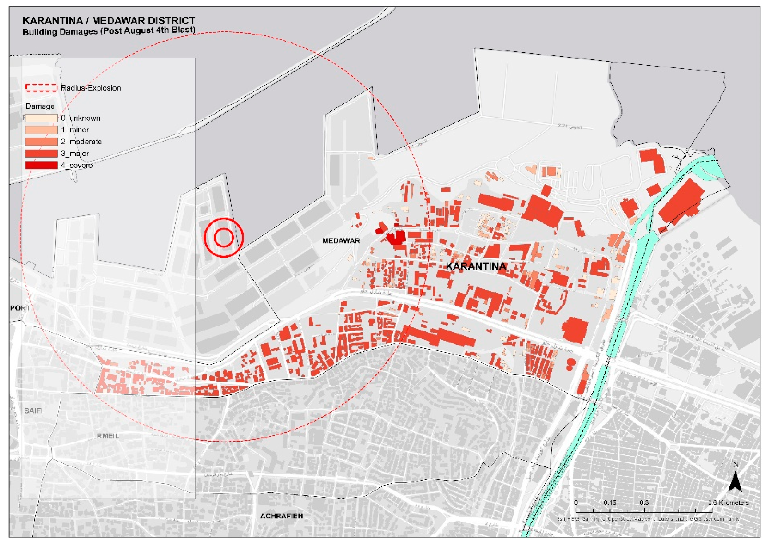
1]. The recent devastating Port of Beirut (POB) blast of August 2020 has further highlighted the many factors that play a deteriorating role in the unsustainable state we find Karantina in today. The
Figure 1 below shows the extent of damages following the blast.
Lebanon has been facing multiple crises over the past years including the economic crisis which has been fast deteriorating since the eventful October 2019 revolution, the global COVID19 pandemic, and the more recent August 2020 Port of Beirut (POB) blast. The latter was the final blow to the already crumbling state which left many people destitute, homeless, and ever more vulnerable. According to the Beirut Rapid and Damage Needs Assessment [
3], the POB resulted in approximately US
$ 3.8–4.6 billion in physical damages. This paper aims to study the effects of the haphazard urbanization of the Karantina area, which was hardest hit by the POB, to assess those indicators that play the most critical role in the development of a sustainable city while improving the overall quality of life, a general well-being which comprises objective descriptors and subjective evaluations of physical, material, social, and emotional well-being [
4], of its urban dwellers while using the recent devastation as an opportunity to adopt these changes. One such example can be seen in the case of Gleisdreieck park where waste land was transformed into recreational green spaces and corridors between 2001 and 2011 and this created a continuous system of paths throughout the city resulting in overall improvement in social and emotional well-being [
5].
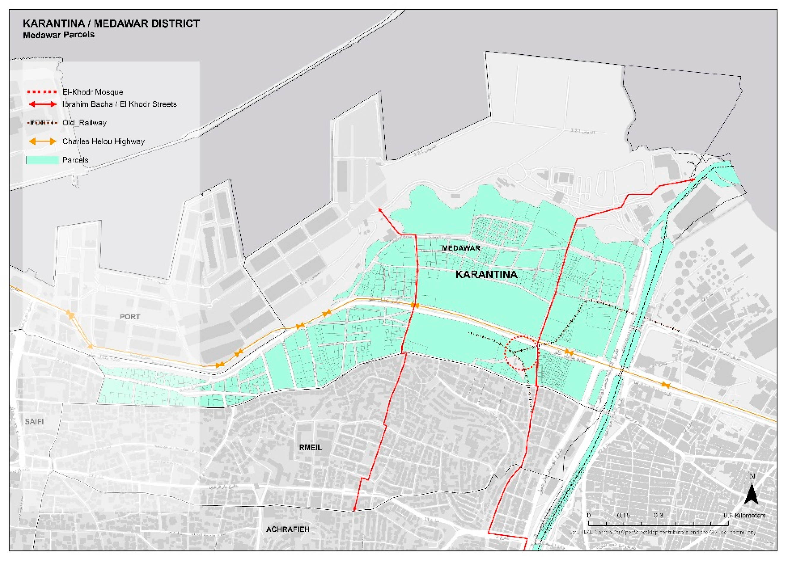
Located on the edge of the port, isolated from Mar Mikhael area by the Charles Helou Highway built in 1958, and bounded from the East by the Beirut river,
Figure 2, Karantina’s urban role changed throughout its history. The neighborhood, which is situated within administrative Beirut area, is named after its original purpose as an Ottoman quarantine facility, built in the 1830s. In the early 1900s it became a work destination for rural-urban migrants and workers from nearby countries. It was also a destination for Armenians, Kurds, and Palestinians seeking refuge after the Armenian Genocide of 1915, World War I, and the 1948 Nakba [
6]. Over time, Karantina grew into a working-class neighborhood providing labor to the local trade, weaving, and handicrafts industries in the 1960s. During the Lebanon civil war (1975–1991), the area was a site of confrontation between fighting factions. Since 2011, the area has become home to migrant workers and a Syrian community that fled the war. Karantina, which is adjacent to the Port of Beirut, was amongst the areas hardest hit by the blast of August 2020,
Figure 3,
Table 1. All data included in
Table 1 were based on surveys conducted by the Order of Engineers and Architects [
7] and respective figures were redrawn and recalculated accordingly.
Karantina is the oldest and largest squatter settlement in Beirut, and occupies a large part of the Medawar locality. It is a transit town, occupying inner-city land of high and rising commercial value. The land previously belonged to a cement factory which moved to the north of the country, and which was later sold to private individuals and institutions. The settlement started by an emigration of people from Turkey, Syria, Palestine, and the rural areas of Lebanon. Between 1932 and 1947 there was a progressive increase in the number of immigrants and between 1952 and 1962 there was a constant flow of immigrants from the South of Lebanon due to unstable political conditions. The choice of settling in Karantina is in view of different factors and namely due to: proximity to workplaces, availability of public schools, efficient public transportation, the presence of the main industrial area of Beirut, and the Port of Beirut [
6]. That being said, the Port of Beirut zone creates a high sense of insecurity due to the strong presence of military and fencing that prevailed even before the blast. Karantina is also considered a poor area. Its poverty status is historically closely intertwined with its history as a quarter in which sea travelers were quarantined to curb the spread of diseases including cholera and tuberculosis during the 1800s. Presently, the neighborhood is still one of Lebanon’s poorest and is predominantly home to working-class Lebanese, Syrian, and Palestinian refugees, among other migrant workers and displaced groups [
8].
This paper shows the importance of implementing sustainable urban planning practices in the design of a city that has been devastated as a result of numerous natural as well as man-made factors. The more recent POB blast offers an opportunity to adopt these sustainable interventions in an inclusive manner taking into consideration the feedback and participation of citizens and all other stakeholders.
2. Materials and Methods
This section will describe the methodology which will be adopted to assess and analyze selected parameters that aim to improve the sustainable development of the city with focus on the Karantina case study area which was recently devastated by the POB blast. The parameters which will be considered include urban fabric, open spaces, heritage, infrastructure, and vacant lots with an emphasis on the impact of participation of key stakeholders, including NGOs and CSOs, for a participatory approach to ensuring an improved quality of life. The latter will be assessed further in the discussion section of this paper.
The typo-morphology of the urban fabric of Karantina is unique and stems from its historical background described above. The urban elements that are intricate parts of the city are, through the recognition of existing urban forms, supplemented by existing or desired functions in the adjacent neighborhoods. The morphological studies are predominantly scrutinized under the analysis of the building/plot or lot, street/city block, and city and region.
The study of the typo-morphology of the urban fabric of Karantina is used in this paper as part of the methodology to introduce new sustainable urban planning tools within the context of Beirut city planning. This paper therefore assesses the urban fabric of Karantina based on the following parameters:
A high number of vacant parcels.
Mixed fabrics with a predominantly large-scale industrial environment and footprint.
Unorganized, small-scale, semi-detached individual residential fabric, residual of the Armenian camps of 1936 and other settlements.
Severely damaged buildings.
A numerous number of parcels and lots are classified as heritage.
Predominantly poor social classes.
Isolated from its surrounding neighborhoods.
Undefined character/identity.
To carry out this work, the analysis of the characteristics of the urban fabric will mainly rely on the use of available data in Karantina, namely the background cadastral and aerial views from search engines, as well as on the field visits and research. The available data presented in
Table 2,
Table 3,
Table 4 and
Table 5 below were compiled using ArcGIS based on base maps prepared by the Lebanese Army, the Lebanese Red Cross, the Order of Engineers and Architects of Beirut, and the Beirut Urban Lab which was also responsible for the preparation of the Beirut Built Environment Database.
Although within the Karantina area there are many vacant parcels, small parks, and the presence of the old Mar Mikhael train station which has not been operational since the early 1900s, its relationship to public space is unclear. There is a high number of unbuilt vacant lots in Medawar (36% of the total parcels area) which are present within the urban fabric,
Figure 4,
Table 2. Non-constructible parcels (3.16% of the total parcels area) are small area parcels (less than 200 sqm) and create certain gaps in the urban fabric. They are often derelict spaces, private or public, used mostly as parking lots and generator platforms [
9] but which can be put to better use and particularly in the form of green spaces.
The parcels’ sizes vary from 21 sqm to 14,600 sqm for an average parcel size of 567 sqm and a total area of 155,134 sqm. The total area of parcels in Medawar is 807,765 sqm.
The parcels in Karantina differ in size and shape
Figure 5; on its western and eastern edges there are small scale parcels that are used to host immigration camps and housing for labor, while the core of the area is occupied by large scale parcels that host industrial facilities.
On Charles Helou Highway, we find a series of high buildings, mostly recent office spaces, the Beirut fire station, and a series of small buildings on its western edge, residues of the old dense St. Michel camp. Inside the area, what used to be a dense Armenian camp back in 1936 has now given way to large scale industrial facilities (
Figure 6 and
Figure 7). The Mar Mikhael train station is occupied by few historical buildings and two large scale hangars. The area has become a graveyard for old buses and train skeletons.
The residential buildings, although higher in numbers, consist of only 8.5% of the total building footprint of the area with an average footprint of 174 sqm.
After the blast, UN Habitat had surveyed poverty zones in the areas of Medawar and Rmeil
Figure 8. and it is important to note that within residential areas of Karantina most were identified as all poor or half poor, which depicts a social fabric in desperate need for intervention of some kind. One of the poorest areas in the middle of Karantina is Arab El-Maslakh. The area consists of four blocks that are currently isolated within a larger area with industries and unused plots.
In Karantina, the largest parcel to hold the most heritage buildings is the one facing the Mar Mikhael train station; it holds 46 classified buildings
Figure 9.
The methodology in this paper aims to merge the various parameters that have shaped the typo-morphology of the urban fabric of Karantina over the past years through ArcGIS. This exercise helps to better understand the intricate link between these selected parameters including, among others, vacant lots, non-constructible parcels, heritage buildings, land use, and poverty pockets, and identifies potential opportunities to build back a better, more sustainable, and improved quality of life in the Beirut city planning.
4. Discussion
Lack of housing, overconsumption of natural resources, poverty, inequality, pollution, and instabilities in social and cultural values are all urbanization challenges which should be addressed by refining the urban planning of sustainable neighborhoods and cities. In order to support the urban future development and to build a sustainable relationship between urban citizens and urban spaces, UN-Habitat has recommended adequate space for streets and an efficient street network; efficient land use to accommodate more urban dwellers, provide social equity, increase energy efficiency, and reduce pollution; mixed land use to provide local jobs, promote the local economy, minimize car dependency, and support mixed economies; a good social mix that aims to ensure urban equity in terms of housing and promote the interaction between social classes in a community; and limited land use specialization that aims to limit or adjust the zoning policies.
Amid unclear public policies, vague decision-making process, missing planning institutions and uncoordinated planning actions and implementation, Lebanon faces many challenges to achieve a more sustainable and inclusive role. Developing a regional planning framework is one of the tools that can successfully contribute to shifting this trend from a stagnant situation to a more interactive and forward driven mechanism.
“One of its central goals is to overcome the different fragmentation processes that cut into the social fabric, leading to the exclusion of individuals and social groups from access to different common goods that are considered essential today, such as elementary social rights, education, basic services, housing and employment” [
13].
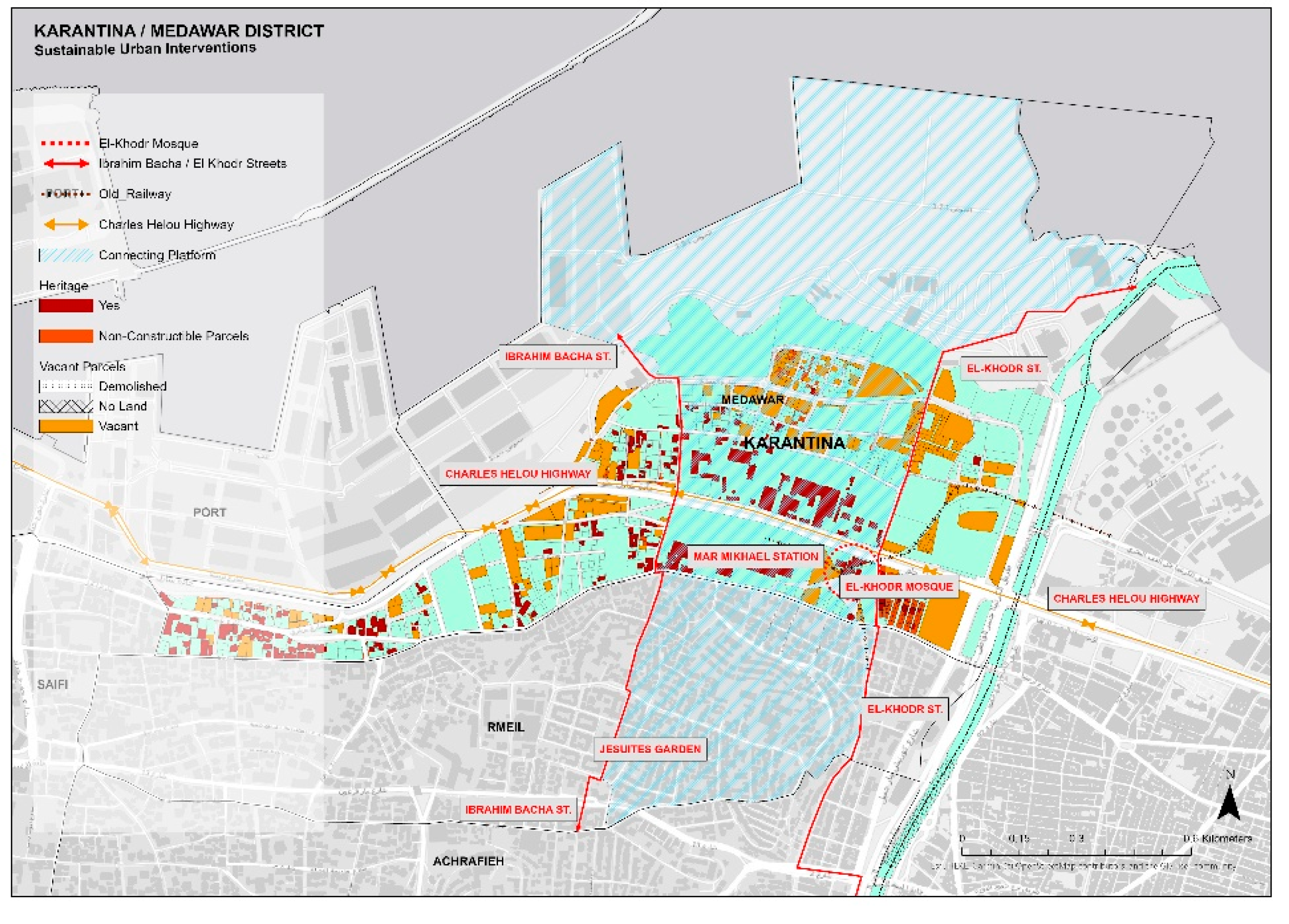
This paper shows that by reactivating the vacant lots and non-constructible parcels in Karantina as identified in the above sections, reactivating the northern and southern ends of Ibrahim Bach and El Khodr streets which has presently been cut by the Charles Helou Avenue, and reclaiming the role of El Khodr mosque as an urban landmark with surrounding open spaces, the Karantina area will be relinked to the city, will have more opportunity for open and green spaces, and will ease the transport and commute times between Karantina and the main city. These all allow for the sustainable development of the Karantina area, thus improving the overall quality of life of residents and thereby contributing to diminishing commute time, improving air quality, mitigating urban overheating [
14], and transforming loose spaces into public spaces within neighborhoods which families and the community can enjoy.
While the repurposing of urban vacant land will not redress the causal roots of systemic inequalities, such interventions can still be pertinent for daily public life in cities. While Lebanon experiences multiple crises and its people struggle more every day, solidarities are direly needed, and spaces where people can meet and connect would play a key role in nurturing these solidarities. Vacant parcels can be such spaces, where playgrounds, food banks, and basic infrastructure can emerge, and where new forms of communal life can be experimented with [
15].
However, achieving this reform requires connecting different actors and stakeholders. Politicians, planners, sociologists, anthropologists, technicians, economists, and civil activists must be included in the urban development process, working on spaces, construction materials, and building tools combining this knowledge with a set of legal, administrative, managerial, conceptual, scientific, literary, and negotiation tools. This bottom-up approach is essentially based on building on many small development initiatives, each focused on a specific topic of interest, reacting to problems that are preventing the instauration and development of sustainable planning.
Thus, social inclusion and the role that citizens play in a sustainable development strategy can be beneficial through a voluntary contribution to neighborhood development. Similar such successful cases have been seen in neighboring countries such as Jordan and UAE as discussed above. Integrating adequate programs, like meet, play, work, gather, plant, and introducing initiatives in urban vacancies can respond to the needs of the neighborhood, ranging from infrastructure to agriculture, and thus generate a sense of collective ownership while at the same time improving the quality of the surrounding environment. Such initiatives usually do not require much capital investments or maintenance, can be managed communally, and operated temporarily, yielding fast results.
Other cities with similar contextual and economic backgrounds which have implemented sustainable urban planning practices as per the United Nations Sustainable Development Goal 11 (Sustainable Cities and Communities) [
16] to improve the overall quality of life were also referred to in this paper. As noted, Beirut is a divided city, and case studies of divided cities like Berlin, Belfast, or Jerusalem indicate that contemporary planning interventions in divided cities rarely address the root causes of division. Beirut, Belfast, and Berlin are cities torn between war and peace, with strong city memory, with unique contexts and contested spaces. Difference and diversity as a prominent feature of the city should hence be incorporated in any planning approach, even if the consequences on the ground may differ. Considering that planning could change the spatial, economic, social, and political dimensions of a defined urban space, it would be crucial to depict which of these dimensions can be used to intensify or lessen contestations over space in divided cities [
4]. Beirut has always functioned as a multicultural city where religious groups coexisted, but lived in separate enclaves, with few mixed neighborhoods [
17]. This is strongly evident in Karantina, an area that experienced intense political conflict during the Lebanese civil war which has left strong marks in the neighborhood social fabric.
Since its reunification, Berlin has adopted “Green city for 2030” as an action program and pursuing the long-term goal of making Berlin a climate-neutral city by 2050. It contains specific projects, measures, and instruments to meet the challenges formulated in the document and to achieve its objectives. The socio-economic reality of Berlin in 2020 is of a city that is strongly socially segregated between a wealthy and very well-off population on the one hand and a growing number of urban poor on the other—an inequality that has been on the rise since the double coronavirus crisis [
18]. Although Berlin is way ahead today in its quest for sustainability, from 2001 till 2011, Berlin was, similarly to Beirut, going through difficult political, economic, and social crisis. A spatially targeted program that sought to solve social problems at the neighborhood level was set up introducing the “neighborhood management” as a main tool. By introducing a small-scale governance structure, the “‘neighborhood manager”, it created an intermediate level between the municipality, citizens, and other local actors [
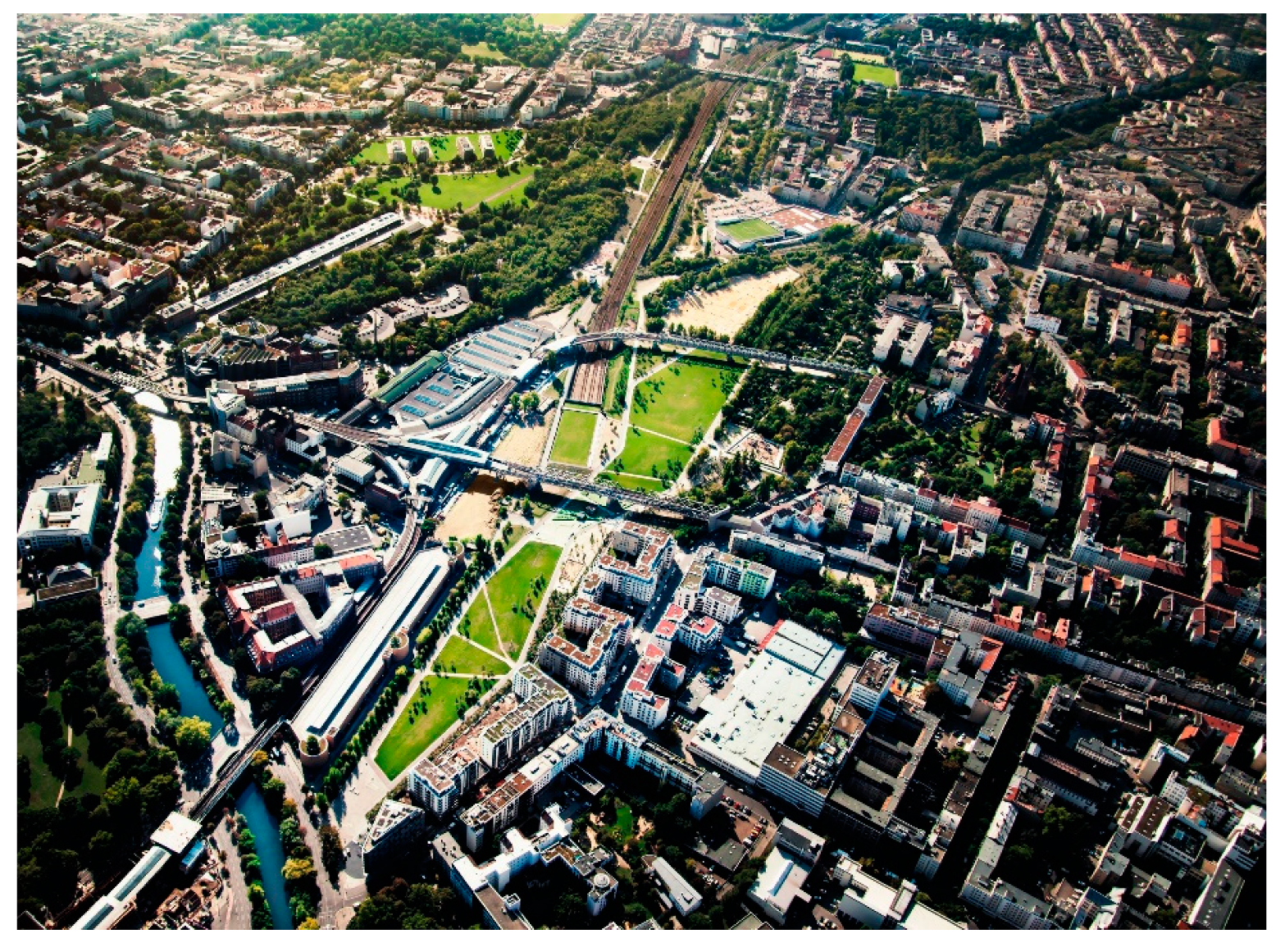
18]. Abandoning large-scale foreign investment, understanding the city demographics, transforming industrial facilities into cultural and creative hubs, and developing affordable living and working spaces were at the core of this strategy. Landscape projects such as the Gleisdreieck park
Figure 14 were inaugurated, focusing on the north-south green corridor that creates a continuous system of paths throughout the city in a decision to dedicate this former wasteland into green and recreational spaces.
Mending emotional, spiritual, and socio-cultural connections becomes critical for any process of recovery—with cultural heritage, that includes sites of social significance and shared memories—serving as a catalyst for a successful recovery process. In this sense, cultural recovery operates beyond the limited definition of heritage tied to the physical and historical and goes beyond the urgent recovery process that is people-centered, heritage-led, and place-specific to address post-disaster basic needs. Crucially, it attends to socio-spatial practices that are part of the intangible heritage, and rebuilds, over the long-term, undermined cultural practices, social ties, and economic networks. Such industrial neighborhoods and informal settlements as Karantina, characterized by a deep social, cultural, and economic history, are therefore as deserving as any other neighborhood of a recovery process that is people-centered, heritage-led, and place-specific [
14].


