How Does the Location of Urban Facilities Affect the Forecasted Population Change in the Osaka Metropolitan Fringe Area?


Abstract
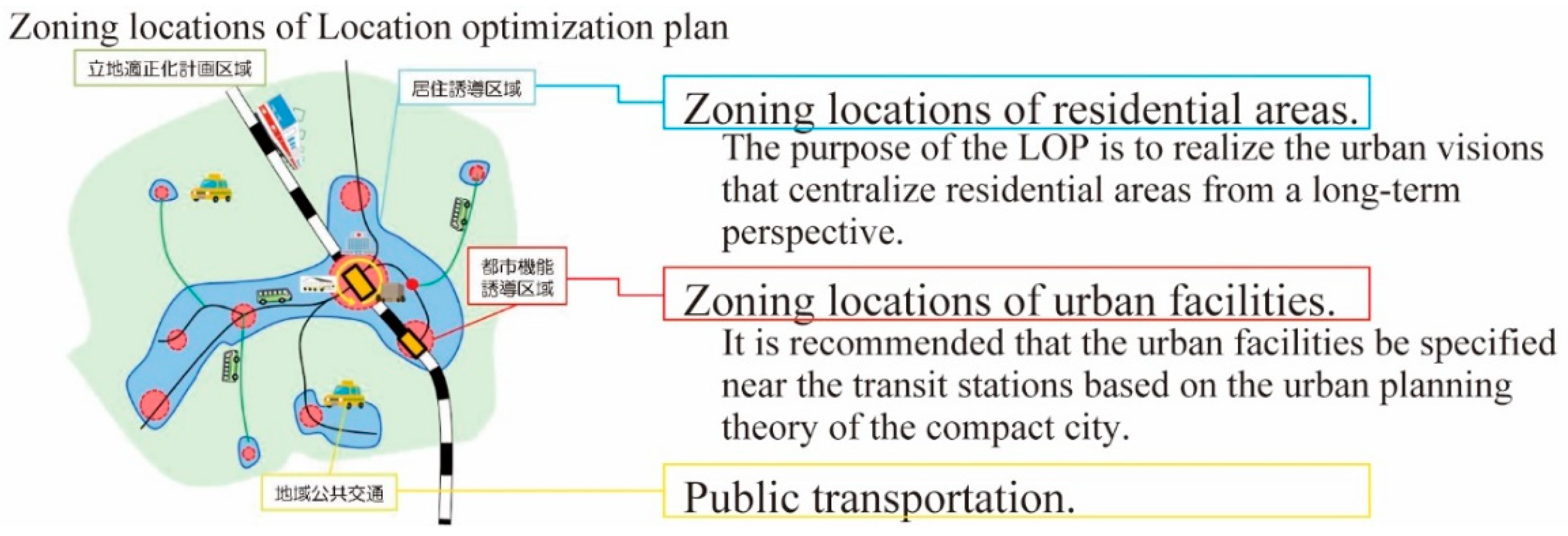
1. Introduction
2. Materials and Methods
2.1. Urban Ecological Analysis
2.2. Cohort Component Method
2.3. Bayesian Network Analysis
3. Results
3.1. Categories of Residential Clusters
3.2. Population Decline of Each Residential Cluster
3.3. Formatting of Mathematical Components
4. Discussion and Conclusions
Funding
Institutional Review Board Statement
Informed Consent Statement
Data Availability Statement
Acknowledgments
Conflicts of Interest
Appendix A

| Inner-City Cluster | Business Center Cluster | Mining Industry Cluster | Dense Cluster | Public Housing Cluster | Non-Residential Cluster | Agriculture Cluster | Sprawl Cluster | High-Rise Residential Cluster | Mountain Cluster | Old New-Town Cluster | Suburban Agriculture Cluster | Rural Cluster | |
|---|---|---|---|---|---|---|---|---|---|---|---|---|---|
| N | 1937 | 5472 | 728 | 672 | 889 | 7403 | 297 | 4998 | 628 | 7251 | 2546 | 2914 | 1033 |
| Urbanized area ratio (%) | 84.5 | 86.2 | 45.1 | 77.1 | 72.4 | 55.2 | 23.6 | 66.2 | 61.8 | 40.7 | 59.1 | 21.3 | 24.9 |
| Average distance from the center (km) | 19.3 | 34.5 | 59.9 | 31.2 | 26.7 | 43.9 | 71.6 | 38.2 | 25.9 | 56.1 | 26.7 | 63.1 | 52.1 |
| Population under 15 years old (%) | 0.06 | 0.01 | 0.03 | 0.06 | 0.05 | 0.00 | 0.04 | 0.02 | 0.09 | 0.01 | 0.03 | 0.01 | 0.10 |
| Population between 16 and 64 years old (%) | 0.09 | 0.02 | 0.04 | 0.09 | 0.08 | 0.00 | 0.06 | 0.03 | 0.12 | 0.01 | 0.05 | 0.02 | 0.14 |
| Population over 65 years old (%) | 0.10 | 0.02 | 0.04 | 0.07 | 0.12 | 0.00 | 0.09 | 0.04 | 0.11 | 0.01 | 0.05 | 0.03 | 0.15 |
| Population of Foreigners (%) | 0.09 | 0.02 | 0.02 | 0.04 | 0.07 | 0.00 | 0.01 | 0.02 | 0.03 | 0.00 | 0.01 | 0.00 | 0.05 |
| Population who live in their own houses (%) | 0.09 | 0.02 | 0.04 | 0.07 | 0.05 | 0.00 | 0.07 | 0.03 | 0.13 | 0.01 | 0.05 | 0.02 | 0.15 |
| Population who live in public housing (%) | 0.01 | 0.00 | 0.00 | 0.01 | 0.12 | 0.00 | 0.01 | 0.00 | 0.01 | 0.00 | 0.00 | 0.00 | 0.01 |
| Population who live in private rented houses (%) | 0.10 | 0.02 | 0.02 | 0.10 | 0.02 | 0.00 | 0.02 | 0.03 | 0.05 | 0.00 | 0.02 | 0.00 | 0.07 |
| Population who live in houses for employees (%) | 0.02 | 0.00 | 0.01 | 0.08 | 0.01 | 0.00 | 0.01 | 0.01 | 0.02 | 0.00 | 0.01 | 0.00 | 0.02 |
| Population who live in shared houses (%) | 0.08 | 0.02 | 0.02 | 0.05 | 0.03 | 0.00 | 0.04 | 0.03 | 0.06 | 0.01 | 0.03 | 0.01 | 0.09 |
| Households who live outside of houses (%) | 0.00 | 0.00 | 0.00 | 0.03 | 0.00 | 0.00 | 0.00 | 0.00 | 0.00 | 0.00 | 0.00 | 0.00 | 0.01 |
| Households who live in detached houses (%) | 0.07 | 0.02 | 0.05 | 0.05 | 0.03 | 0.00 | 0.10 | 0.04 | 0.09 | 0.02 | 0.06 | 0.03 | 0.19 |
| Households who live in traditional nagaya-houses (%) | 0.08 | 0.01 | 0.02 | 0.03 | 0.02 | 0.00 | 0.02 | 0.03 | 0.02 | 0.00 | 0.01 | 0.00 | 0.07 |
| Households who live in apartments (%) | 0.08 | 0.02 | 0.02 | 0.08 | 0.10 | 0.00 | 0.01 | 0.02 | 0.08 | 0.00 | 0.02 | 0.00 | 0.04 |
| Households who live in 1- or 2-storey buildings (%) | 0.05 | 0.02 | 0.04 | 0.07 | 0.02 | 0.00 | 0.04 | 0.05 | 0.05 | 0.00 | 0.03 | 0.01 | 0.16 |
| Households who live in 3- to 5-storey buildings (%) | 0.05 | 0.01 | 0.01 | 0.07 | 0.11 | 0.00 | 0.01 | 0.02 | 0.05 | 0.00 | 0.01 | 0.00 | 0.03 |
| Households who live in 6- to 10-storey buildings (%) | 0.06 | 0.01 | 0.01 | 0.06 | 0.04 | 0.00 | 0.00 | 0.01 | 0.05 | 0.00 | 0.01 | 0.00 | 0.02 |
| Households who live in 11- (or more) storey buildings (%) | 0.03 | 0.00 | 0.00 | 0.02 | 0.04 | 0.00 | 0.00 | 0.00 | 0.04 | 0.00 | 0.01 | 0.00 | 0.00 |
| Population who work in agriculture and forestry (%) | 0.00 | 0.00 | 0.01 | 0.00 | 0.00 | 0.00 | 0.13 | 0.00 | 0.01 | 0.01 | 0.00 | 0.03 | 0.03 |
| Population who work in a fishery (%) | 0.00 | 0.00 | 0.01 | 0.00 | 0.00 | 0.00 | 0.04 | 0.00 | 0.00 | 0.00 | 0.00 | 0.00 | 0.00 |
| Population who work in the mining industry (%) | 0.00 | 0.00 | 0.09 | 0.00 | 0.00 | 0.00 | 0.05 | 0.00 | 0.00 | 0.00 | 0.00 | 0.00 | 0.01 |
| Population who work in the construction industry (%) | 0.08 | 0.01 | 0.04 | 0.06 | 0.07 | 0.00 | 0.07 | 0.04 | 0.09 | 0.01 | 0.04 | 0.02 | 0.15 |
| Population who work in the manufacturing industry (%) | 0.05 | 0.01 | 0.03 | 0.07 | 0.05 | 0.00 | 0.05 | 0.03 | 0.08 | 0.01 | 0.03 | 0.02 | 0.12 |
| Population who work in the electricity, gas, and water supply industries (%) | 0.01 | 0.00 | 0.01 | 0.02 | 0.01 | 0.00 | 0.01 | 0.01 | 0.03 | 0.00 | 0.01 | 0.00 | 0.03 |
| Population who work in the information industry (%) | 0.08 | 0.01 | 0.02 | 0.08 | 0.04 | 0.00 | 0.01 | 0.02 | 0.12 | 0.00 | 0.04 | 0.00 | 0.06 |
| Population who work in the transport industry (%) | 0.08 | 0.02 | 0.03 | 0.07 | 0.10 | 0.00 | 0.05 | 0.04 | 0.09 | 0.01 | 0.04 | 0.02 | 0.14 |
| Population who work in the retail industry (%) | 0.09 | 0.02 | 0.03 | 0.08 | 0.07 | 0.00 | 0.06 | 0.03 | 0.12 | 0.01 | 0.04 | 0.02 | 0.13 |
| Population who work in the financial industry (%) | 0.06 | 0.01 | 0.02 | 0.08 | 0.04 | 0.00 | 0.03 | 0.02 | 0.12 | 0.00 | 0.04 | 0.01 | 0.08 |
| Population who work in the real estate business (%) | 0.09 | 0.02 | 0.03 | 0.08 | 0.06 | 0.00 | 0.02 | 0.03 | 0.12 | 0.01 | 0.04 | 0.01 | 0.08 |
| Population who work as researchers or professionals (%) | 0.06 | 0.01 | 0.02 | 0.07 | 0.04 | 0.00 | 0.03 | 0.02 | 0.11 | 0.01 | 0.04 | 0.01 | 0.07 |
| Population who work in the service industry (%) | 0.09 | 0.02 | 0.03 | 0.07 | 0.07 | 0.00 | 0.06 | 0.03 | 0.09 | 0.01 | 0.04 | 0.01 | 0.12 |
| Population who work in the entertainment industry (%) | 0.06 | 0.01 | 0.02 | 0.05 | 0.05 | 0.00 | 0.04 | 0.02 | 0.07 | 0.01 | 0.03 | 0.01 | 0.09 |
| Population who work in education (%) | 0.06 | 0.02 | 0.03 | 0.08 | 0.04 | 0.00 | 0.05 | 0.02 | 0.13 | 0.01 | 0.05 | 0.02 | 0.10 |
| Population who work in the medical/welfare industry (%) | 0.07 | 0.02 | 0.03 | 0.07 | 0.07 | 0.00 | 0.06 | 0.03 | 0.11 | 0.01 | 0.04 | 0.02 | 0.13 |
| Population who work in a joint service industry (%) | 0.05 | 0.01 | 0.05 | 0.06 | 0.05 | 0.00 | 0.18 | 0.03 | 0.09 | 0.02 | 0.04 | 0.05 | 0.18 |
| Population who work in another service industry (%) | 0.09 | 0.02 | 0.04 | 0.08 | 0.10 | 0.00 | 0.06 | 0.04 | 0.11 | 0.01 | 0.04 | 0.02 | 0.14 |
| Population who work as civil servants (%) | 0.02 | 0.00 | 0.01 | 0.05 | 0.01 | 0.00 | 0.02 | 0.01 | 0.04 | 0.00 | 0.01 | 0.01 | 0.04 |
| Population who work at home (%) | 0.08 | 0.02 | 0.04 | 0.06 | 0.04 | 0.00 | 0.18 | 0.03 | 0.07 | 0.01 | 0.03 | 0.05 | 0.13 |
| Population who work in their own city (%) | 0.06 | 0.01 | 0.04 | 0.07 | 0.06 | 0.00 | 0.07 | 0.03 | 0.07 | 0.01 | 0.03 | 0.02 | 0.14 |
| Population who work in other cities (%) | 0.07 | 0.01 | 0.03 | 0.07 | 0.06 | 0.00 | 0.04 | 0.02 | 0.11 | 0.01 | 0.04 | 0.01 | 0.10 |
| Population who work in other wards of their own cities (%) | 0.07 | 0.01 | 0.01 | 0.01 | 0.03 | 0.00 | 0.00 | 0.00 | 0.01 | 0.00 | 0.00 | 0.00 | 0.00 |
| Population who work in other cities of their own prefectures (%) | 0.03 | 0.00 | 0.02 | 0.07 | 0.05 | 0.00 | 0.05 | 0.03 | 0.09 | 0.01 | 0.04 | 0.01 | 0.12 |
| Population who work in other prefectures (%) | 0.03 | 0.01 | 0.02 | 0.07 | 0.03 | 0.00 | 0.01 | 0.01 | 0.15 | 0.00 | 0.05 | 0.01 | 0.05 |
| Population who go to school in their own city (%) | 0.04 | 0.01 | 0.02 | 0.06 | 0.04 | 0.00 | 0.04 | 0.02 | 0.07 | 0.01 | 0.03 | 0.01 | 0.09 |
| Population who go to school in other cities (%) | 0.07 | 0.01 | 0.03 | 0.06 | 0.06 | 0.00 | 0.04 | 0.03 | 0.14 | 0.01 | 0.05 | 0.01 | 0.11 |
| Population who go to school in other wards of their own cities (%) | 0.07 | 0.02 | 0.01 | 0.01 | 0.03 | 0.00 | 0.00 | 0.00 | 0.01 | 0.00 | 0.00 | 0.00 | 0.00 |
| Population who go to school in other cities of their own prefectures (%) | 0.04 | 0.01 | 0.03 | 0.06 | 0.06 | 0.00 | 0.06 | 0.03 | 0.13 | 0.01 | 0.05 | 0.02 | 0.13 |
| Population who go to school in other prefectures (%) | 0.04 | 0.01 | 0.02 | 0.06 | 0.03 | 0.00 | 0.03 | 0.02 | 0.16 | 0.01 | 0.05 | 0.01 | 0.08 |
| Population who have lived in the area since birth (%) | 0.07 | 0.02 | 0.05 | 0.06 | 0.05 | 0.00 | 0.13 | 0.04 | 0.10 | 0.02 | 0.04 | 0.05 | 0.17 |
| Population who have lived in the area for 1 year (%) | 0.06 | 0.02 | 0.02 | 0.10 | 0.05 | 0.00 | 0.03 | 0.03 | 0.07 | 0.00 | 0.03 | 0.01 | 0.08 |
| Population who have lived in the area for the past 5 years (%) | 0.06 | 0.01 | 0.02 | 0.08 | 0.06 | 0.00 | 0.03 | 0.02 | 0.08 | 0.00 | 0.03 | 0.01 | 0.09 |
| Population who have lived in the area for the past 10 years (%) | 0.07 | 0.01 | 0.03 | 0.07 | 0.07 | 0.00 | 0.04 | 0.03 | 0.12 | 0.01 | 0.04 | 0.01 | 0.11 |
| Population who have lived in the area for the past 20 years (%) | 0.08 | 0.02 | 0.03 | 0.07 | 0.08 | 0.00 | 0.05 | 0.03 | 0.15 | 0.01 | 0.05 | 0.01 | 0.13 |
| Population who have lived in the area for over 20 years (%) | 0.07 | 0.02 | 0.04 | 0.05 | 0.08 | 0.00 | 0.08 | 0.03 | 0.09 | 0.01 | 0.05 | 0.02 | 0.15 |
References
- Japan National Institute of Population and Social Security Research. Population and Social Security in Japan 2019. IPSS Res. Rep. 2019, 85, 1–16. [Google Scholar]
- Mallach, A.; Haase, A.; Hattori, K. The shrinking city in comparative perspective: Contrasting dynamics and responses to urban shrinkage. Cities 2017, 69, 102–108. [Google Scholar] [CrossRef]
- Lee, J.W.; Sung, J.S. Conflicts of Interest and Change in Original Intent: A Case Study of Vacant and Abandoned Homes Repurposed as Community Gardens in a Shrinking City, Daegu, South Korea. Sustainability 2017, 9, 2140. [Google Scholar] [CrossRef]
- Yang, Z.S. Sustainability of Urban Development with Population Decline in Different Policy Scenarios: A Case Study of Northeast China. Sustainability 2019, 11, 6442. [Google Scholar] [CrossRef]
- Grossmann, K.; Bontje, M.; Haase, A.; Mykhnenko, V. Shrinking cities: Notes for the further research agenda. Cities 2013, 35, 221–225. [Google Scholar] [CrossRef]
- Hattori, K.; Kaido, K.; Matsuyuki, M. The development of urban shrinkage discourse and policy response in Japan. Cities 2017, 69, 124–132. [Google Scholar] [CrossRef]
- Japanese MILT (Ministry of Land, Infrastructure, Transport and Tourism). Basic Plan on Transport Policy. Available online: https://www.mlit.go.jp/common/001096409.pdf (accessed on 15 September 2020).
- Wang, Y.P.; Fukuda, H. Sustainable Urban Regeneration for Shrinking Cities: A Case from Japan. Sustainability 2019, 11, 1505. [Google Scholar] [CrossRef]
- Ohashi, H.; Phelps, N.A. Diversity in decline: The changing suburban fortunes of Tokyo Metropolis. Cities 2020, 103, 16. [Google Scholar] [CrossRef]
- Yoon, C.J. Between the Ideal and Reality of City Resizing Policy: Focused on 25 Cases of Compact City Plans in Japan. Sustainability 2020, 12, 989. [Google Scholar] [CrossRef]
- Nelle, A.; Grossmann, K.; Haase, D.; Kabisch, S.; Rink, D.; Wolff, M. Urban shrinkage in Germany: An entangled web of conditions, debates and policies. Cities 2017, 69, 116–123. [Google Scholar] [CrossRef]
- Bernt, M. The emergence of “Stadtumbau Ost”. Urban. Geography 2019, 40, 174–191. [Google Scholar] [CrossRef]
- Hackworth, J. Right-sizing as spatial austerity in the American Rust Belt. Environ. Plan. A 2015, 47, 766–782. [Google Scholar] [CrossRef]
- Sarzynski, A.; Vicino, T.J. Shrinking Suburbs: Analyzing the Decline of American Suburban Spaces. Sustainability 2019, 11, 5230. [Google Scholar] [CrossRef]
- Demographia. Demographia World Urban Areas 16th Annual Edition 2020.06. Available online: http://www.demographia.com/db-worldua.pdf (accessed on 15 September 2020).
- Kato, H.; Kanki, K. Development of Walkability Indicator for Smart Shrinking: Case Study of Sprawl Areas in Northern Osaka Metropolitan. Int. Rev. Spat. Plan. Sustain. Dev. 2020, 8, 39–58. [Google Scholar] [CrossRef]
- Yamazoe, M.; Kana, K. Study on the Urbanisation Promotion Areas of three Metropolitan areas and their City Classifications and Urban Area Characteristics Seen from their Population Shifts (in Japanese). J. City Plan. Inst. Jpn. 2017, 52, 336–342. [Google Scholar]
- Friedrichs, J. A theory of urban decline-economy, demography and political elites. Urban Stud. 1993, 30, 907–917. [Google Scholar] [CrossRef]
- Haase, A.; Rink, D.; Grossmann, K.; Bernt, M.; Mykhnenko, V. Conceptualizing urban shrinkage. Environ. Plan. Econ. Space 2014, 46, 1519–1534. [Google Scholar] [CrossRef]
- Hitachi Review. Policy Proposal AI Aiming at a Sustainable Future. Available online: https://www.hitachi.com/rev/archive/2019/r2019_04/04c04/index.html (accessed on 15 September 2020).
- Ai, H. Can Living Environment Evaluation Score Forecast Population Change? Map Visualization of Evaluation Score and Population Change Pattern in Tokyo. In Proceedings of the 2017 International Conference of Asian-Pacific Planning Societies, Nagoya city, Japan, 24–26 August 2017. [Google Scholar]
- Ai, H. Can “living environment index” forecast population increase of local districts: An analysis based on local districts within the Greater Tokyo Metropolitan Area. J. City Plan. Inst. Jpn. 2017, 52, 1290–1297. (In Japanese) [Google Scholar]
- Paul, K.; Steven, P. Difference and inequality: Socioeconomic and sociocultural patterns. In Urban Social Geography- an Introduction, 6th ed.; Prentice Hall: Harlow, UK, 2010; pp. 67–83. [Google Scholar]
- Kato, H. Effect of Walkability on Urban Sustainability in the Osaka Metropolitan Fringe Area. Sustainability 2020, 12, 9248. [Google Scholar] [CrossRef]
- E-Stat. Japanese Census data in 2015. Available online: https://www.e-stat.go.jp/ (accessed on 14 June 2020)In Japanese.
- Japanese MILT (Ministry of Land, Infrastructure, Transport and Tourism). National Land Information Download Service. Available online: http://nlftp.mlit.go.jp/ksj/index.html (accessed on 14 March 2020).
- G-spatial Information Center. Future Population and Household Forecast Tool V. 2 (2015 National Census edition” download webpage). Available online: https://www.geospatial.jp/ckan/dataset/cohort-v2 (accessed on 14 March 2020).
- Conrady, S.; Jouffe, L. Bayesian Networks & BayesiaLab-A Practical Introduction for Researchers; Bayesia: Franklin, TN, USA, 2015. [Google Scholar]
- Chow, C.; Liu, C. Approximating discrete probability distributions with dependence trees. IEEE Trans. Inf. Theory 1968, 14, 462–467. [Google Scholar] [CrossRef]
- Hirayama, Y. Neoliberal policy and the housing safety net in Japan. City Cult. Soc. 2010, 1, 119–126. [Google Scholar] [CrossRef]
- Haruka, K.; Kiyoko, K. Evaluating the Walkability of Urban Sprawl Areas in the Future Using Scenario Planning: Smart Decline for Ibaraki City in the Northern Osaka Metropolitan Area. In Proceedings of the 16th International Conference on Computers in Urban Planning and Urban Management, Wuhan University, Wuhan, China, 8–12 July 2019. [Google Scholar]
- Oda, K.; Rupprecht, C.D.D.; Tsuchiya, K.; McGreevy, S.R. Urban Agriculture as a Sustainability Transition Strategy for Shrinking Cities? Land Use Change Trajectory as an Obstacle in Kyoto City, Japan. Sustainability 2018, 10, 1048. [Google Scholar] [CrossRef]
- Koura, H. Old “new towns” in Kobe and future perspectives of inhabitants in shrinking detached housing areas—Case of Takakuradai in Kobe City. In Maturity and Regeneration of Residential Areas in Metropolitan Regions—Trends, Interpretations and Strategies in Japan and Germany; Kadono, Y., Beilein, A., Polívka, J., Reicher, C., Eds.; Universitätsbibliothek Dortmund: Dortmund, Germany, 2017; Volume 2, pp. 130–145. [Google Scholar]
- Japanese MILT (Ministry of Land, Infrastructure, Transport and Tourism). Amendments to the Urban Planning Act and the Urban Revitalization Special Measures Act for Disaster Prevention. Available online: https://www.mlit.go.jp/policy/shingikai/content/001326007.pdf (accessed on 21 September 2020)In Japanese.
- Deguchi, A. From Smart City to Society 5.0. In Society 5.0, a People-Centric Super-Smart Society; Hitachi-UTokyo Laboratory, Ed.; Springer: Singapore, 2020; pp. 43–65. [Google Scholar]
- Herrmann, D.L.; Shuster, W.D.; Mayer, A.L.; Garmestani, A.S. Sustainability for Shrinking Cities. Sustainability 2016, 8, 911. [Google Scholar] [CrossRef]
- Gulachenski, A.; Ghersi, B.M.; Lesen, A.E.; Blum, M.J. Abandonment, Ecological Assembly and Public Health Risks in Counter-Urbanizing Cities. Sustainability 2016, 8, 491. [Google Scholar] [CrossRef]


| Forecasted Population Change Ratio D2040 | ||||||||
|---|---|---|---|---|---|---|---|---|
| ≦−0.53 | ≦−0.35 | ≦−0.17 | ≦0.06 | ≦0.42 | ≦1.03 | >1.03 | ||
| Medical Facilities | ≦0.001 | 8.4 | 26.7 | 28.9 | 19.8 | 10.7 | 4.3 | 1.2 |
| ≦0.002 | 15.5 | 26.3 | 25.2 | 20.0 | 8.9 | 3.1 | 1.0 | |
| ≦0.003 | 11.1 | 27.5 | 27.7 | 18.6 | 11.3 | 2.8 | 1.0 | |
| ≦0.005 | 16.9 | 32.8 | 25.1 | 14.8 | 6.6 | 3.8 | 0.0 | |
| ≦0.008 | 17.1 | 32.5 | 26.0 | 13.8 | 4.1 | 4.1 | 2.4 | |
| ≦0.012 | 21.8 | 34.6 | 20.5 | 12.8 | 5.1 | 3.8 | 1.3 | |
| >0.012 | 25.7 | 36.5 | 21.6 | 12.2 | 2.7 | 1.4 | 0.0 | |
| Forecasted Population Change Ratio D2040 | |||||||
|---|---|---|---|---|---|---|---|
| ≦−0.40 | ≦−0.19 | ≦0.08 | ≦0.52 | ≦1.22 | >1.22 | ||
| Train Stations | ≦0.003 | 17.8 | 32.7 | 29.8 | 12.5 | 4.8 | 2.3 |
| ≦0.008 | 26.6 | 34.2 | 23.7 | 10.4 | 3.8 | 1.3 | |
| ≦0.014 | 28.2 | 40.4 | 19.1 | 8.5 | 2.4 | 1.4 | |
| ≦0.022 | 34.5 | 36.0 | 14.8 | 9.1 | 5.3 | 0.4 | |
| ≦0.040 | 37.9 | 36.2 | 12.1 | 6.9 | 4.3 | 2.6 | |
| >0.040 | 41.4 | 31.0 | 13.8 | 10.3 | 3.4 | 0.0 | |
| Forecasted Population Change Ratio D2040 | |||||
|---|---|---|---|---|---|
| ≦−0.44 | ≦−0.09 | ≦0.62 | >0.62 | ||
| Regional Resources | ≦0.043 | 45.0 | 44.3 | 10.4 | 0.3 |
| ≦0.077 | 43.9 | 42.7 | 9.9 | 3.4 | |
| ≦0.127 | 41.8 | 42.7 | 13.3 | 2.2 | |
| >0.127 | 34.0 | 48.5 | 14.4 | 3.1 | |
Publisher’s Note: MDPI stays neutral with regard to jurisdictional claims in published maps and institutional affiliations. |
© 2020 by the author. Licensee MDPI, Basel, Switzerland. This article is an open access article distributed under the terms and conditions of the Creative Commons Attribution (CC BY) license (http://creativecommons.org/licenses/by/4.0/).
Share and Cite
Kato, H. How Does the Location of Urban Facilities Affect the Forecasted Population Change in the Osaka Metropolitan Fringe Area? Sustainability 2021, 13, 110. https://doi.org/10.3390/su13010110
Kato H. How Does the Location of Urban Facilities Affect the Forecasted Population Change in the Osaka Metropolitan Fringe Area? Sustainability. 2021; 13(1):110. https://doi.org/10.3390/su13010110
Chicago/Turabian StyleKato, Haruka. 2021. "How Does the Location of Urban Facilities Affect the Forecasted Population Change in the Osaka Metropolitan Fringe Area?" Sustainability 13, no. 1: 110. https://doi.org/10.3390/su13010110
APA StyleKato, H. (2021). How Does the Location of Urban Facilities Affect the Forecasted Population Change in the Osaka Metropolitan Fringe Area? Sustainability, 13(1), 110. https://doi.org/10.3390/su13010110