Assessing the Effectiveness of Precision Agriculture Management Systems in Mediterranean Small Farms

 ,
,  ,
,  and
and 
Abstract
:1. Introduction
2. Materials and Methods
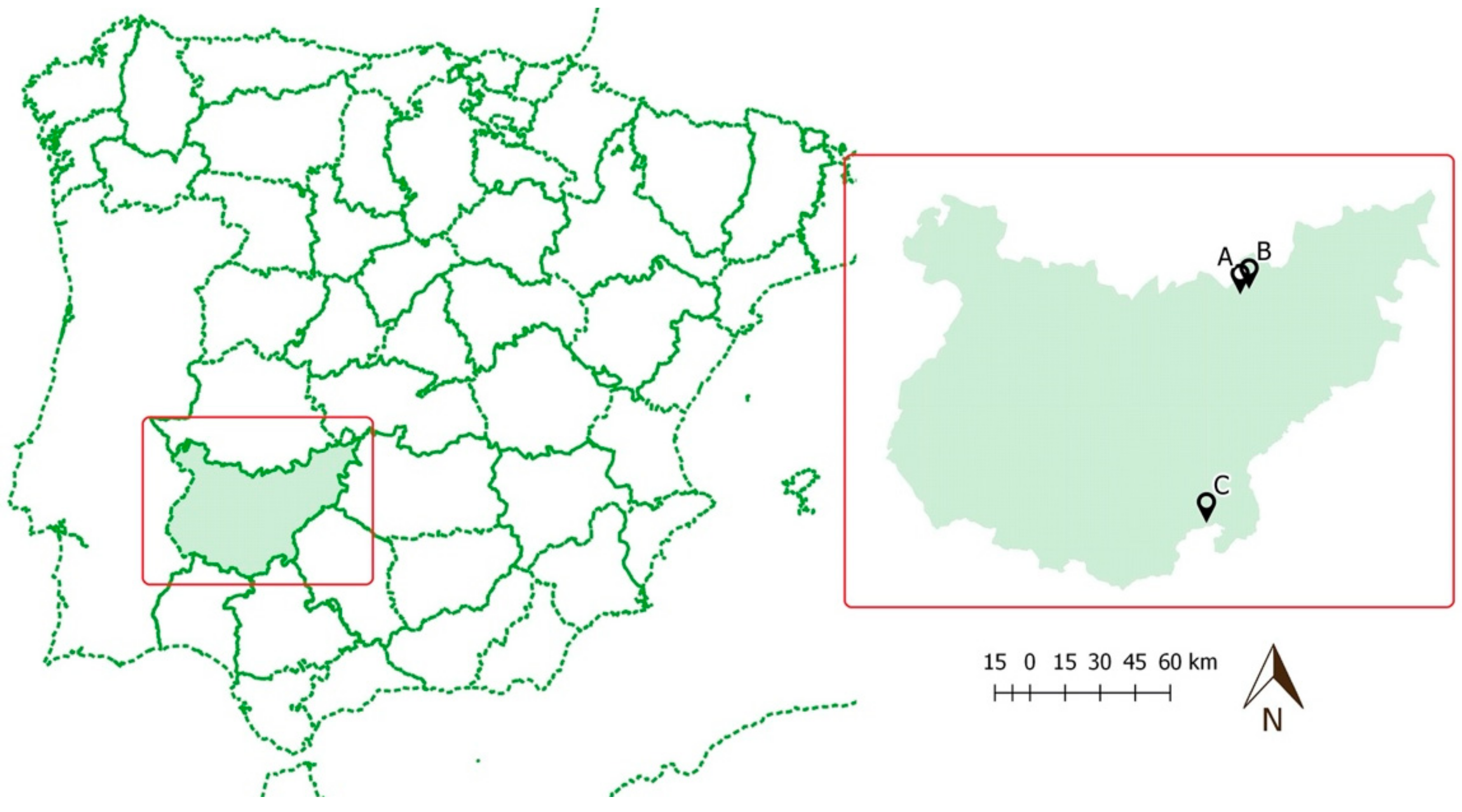
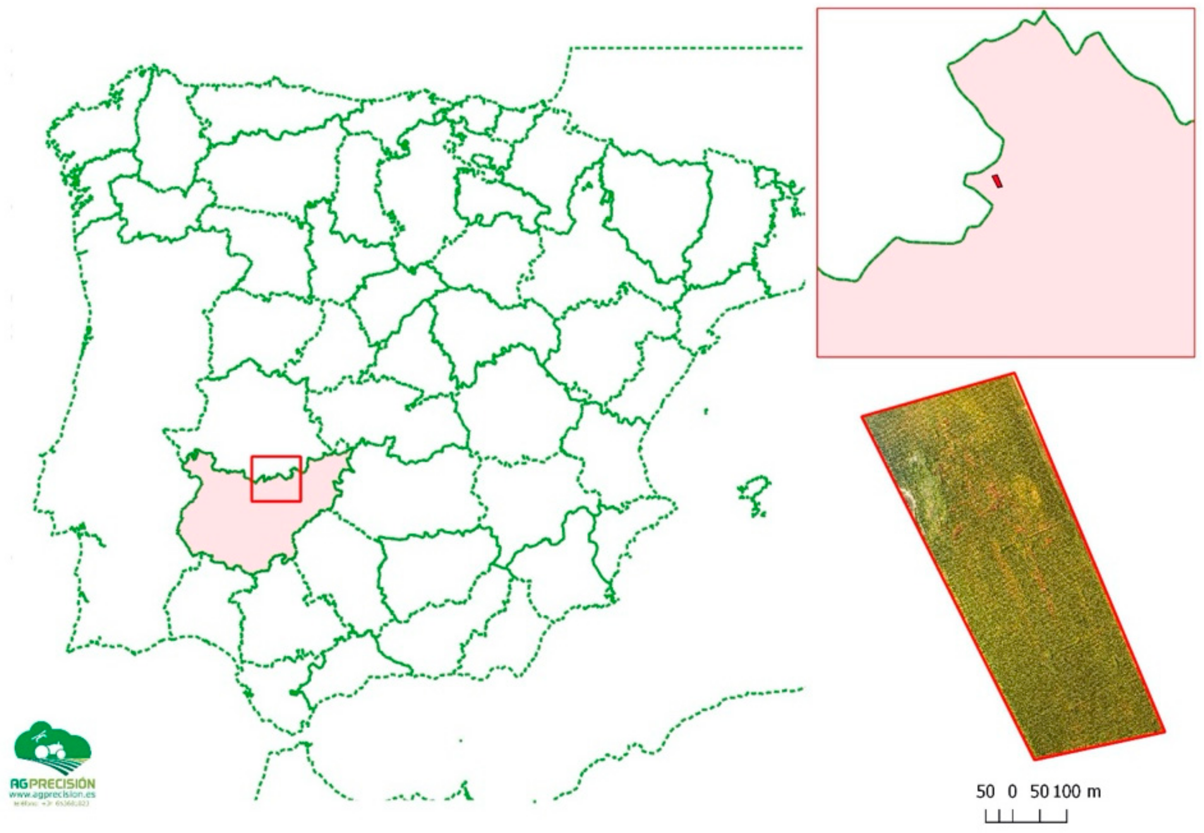
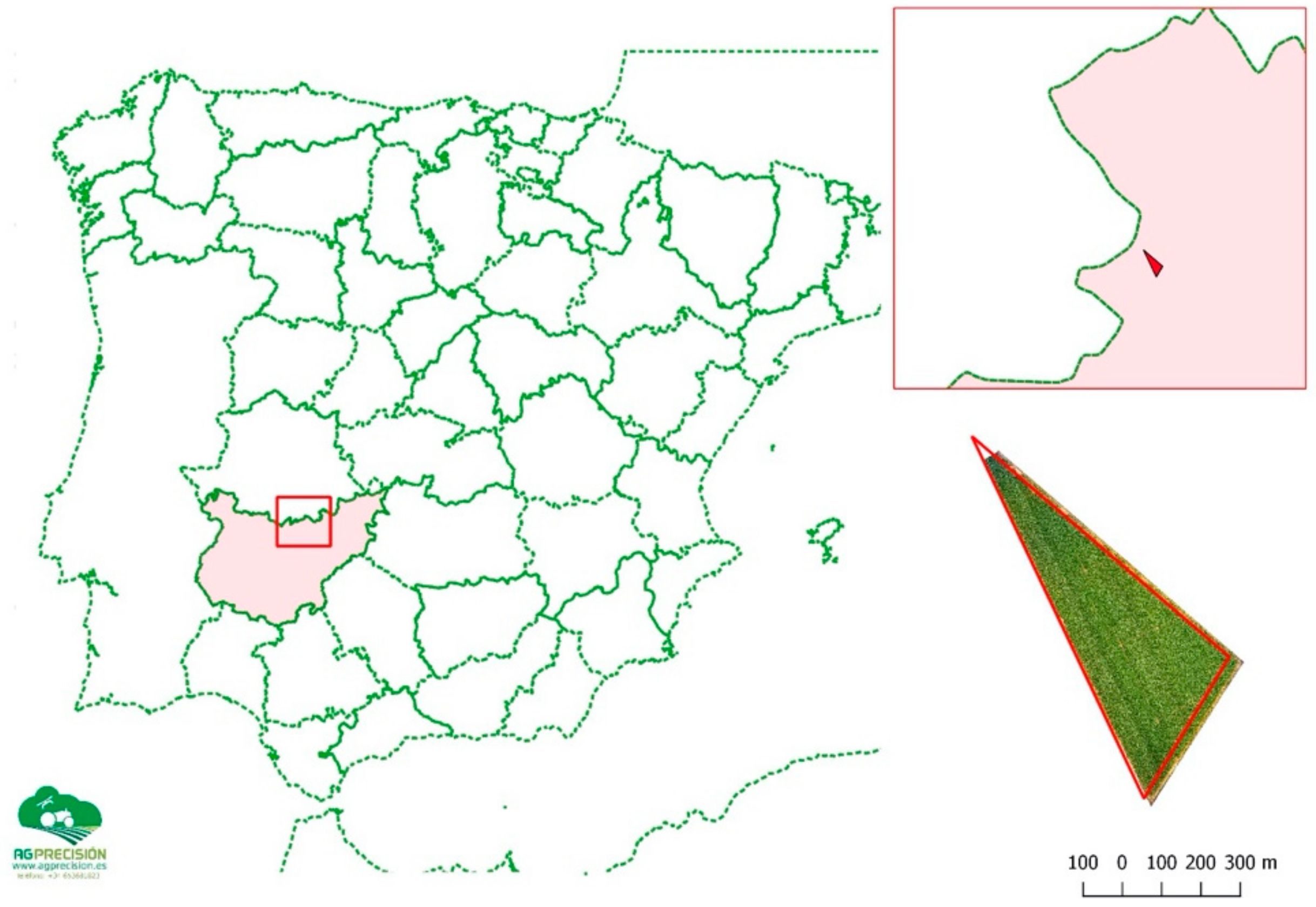
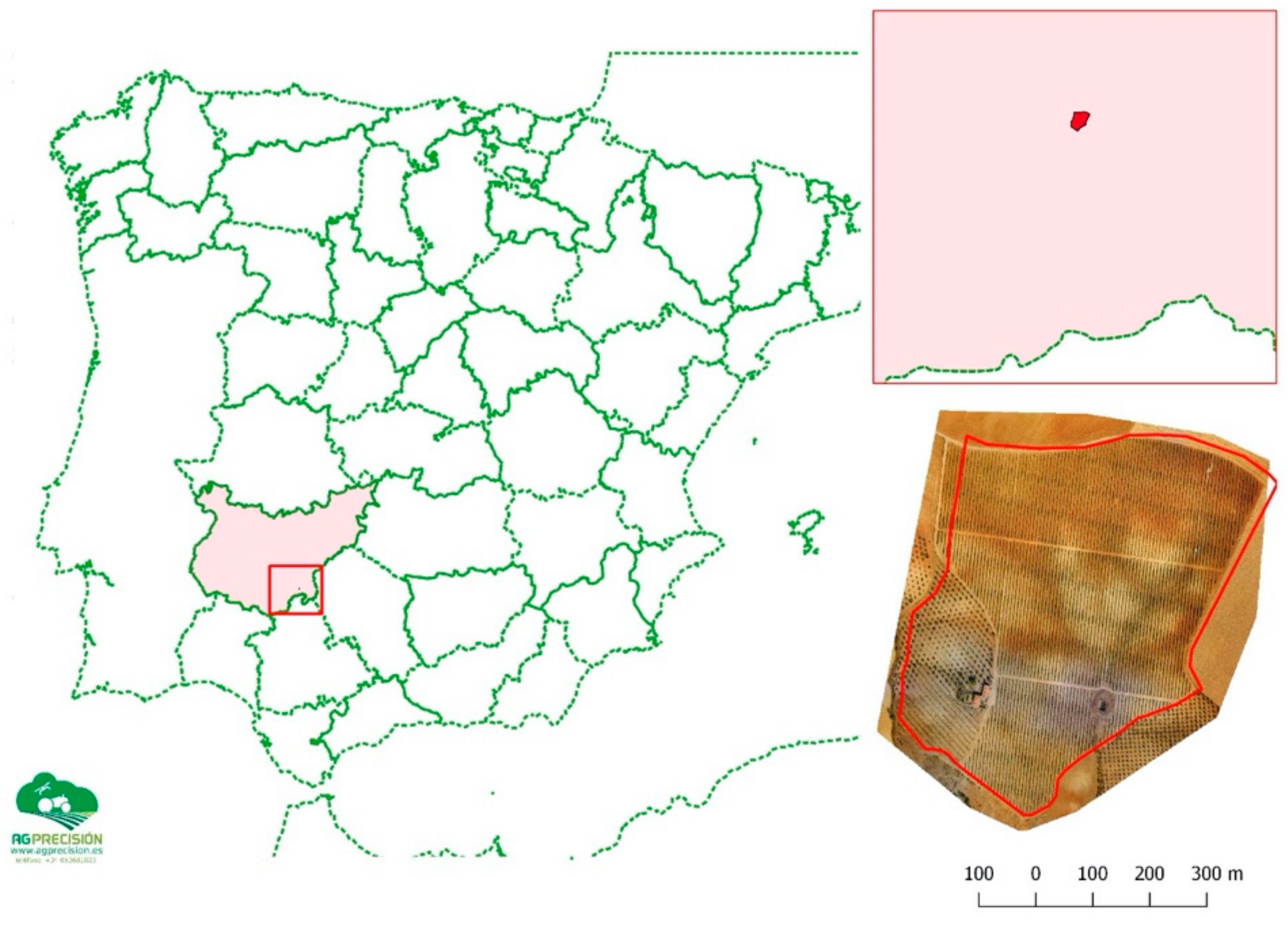
2.1. Study Area(s)
- Plot A—irrigated parcel of 19.8 hectares dedicated to the production of corn
- Plot B—irrigated parcel of 17.4 hectares dedicated to the production of corn
- Plot C—irrigated parcel of 28.8 hectares dedicated to olive production
2.2. Methodological Approach—Work Plan
- i)
- Property selection–with the intention of covering the main crops and the most used watering systems at the regional level, the selection was made bearing in mind, on the one hand, the possibility of accessing data from previous years and, on the other hand, the objective of testing the feasibility of the use of drones (UAS/RPAS) in small size agriculture enterprises;
- ii)
- Property data collection–the process was based on the collection and analysis of as much data as was possible, within the boundaries set by the research schedule, considering not only the abovementioned objective, but also the fact that specific criteria associated with the Mediterranean edaphic characteristics should be verified. For this purpose, besides the available data, four soil samples were collected in each property and analyzed in order to verify that there were not significant differences within the property and the fertility of the assessed properties;
- iii)
- Flight plan and data analysis–the definition of the flight plan was a crucial component of the study, since—as mentioned before, and as agreed with the producers—the research should not cause any inconvenient for farming activities. In this regard, and considering the objectives of the present research, after meeting with the client and with the internal team, a flight plan–data collection protocol was established, considering, among other issues, the post-processing and analysis objectives and the expected outputs/results, e.g., yields map, variable herbicide applications map, ripening state map, vigorousness map. The flight plan considered all the relevant flight characteristics, such as the area, duration, flight height, the number of georeferenced images that were going to be captured and the average stored information.
2.3. Used Technologies/Equipments
2.3.1. RPAS
2.3.2. Cameras/Sensors
2.3.3. Image Processing
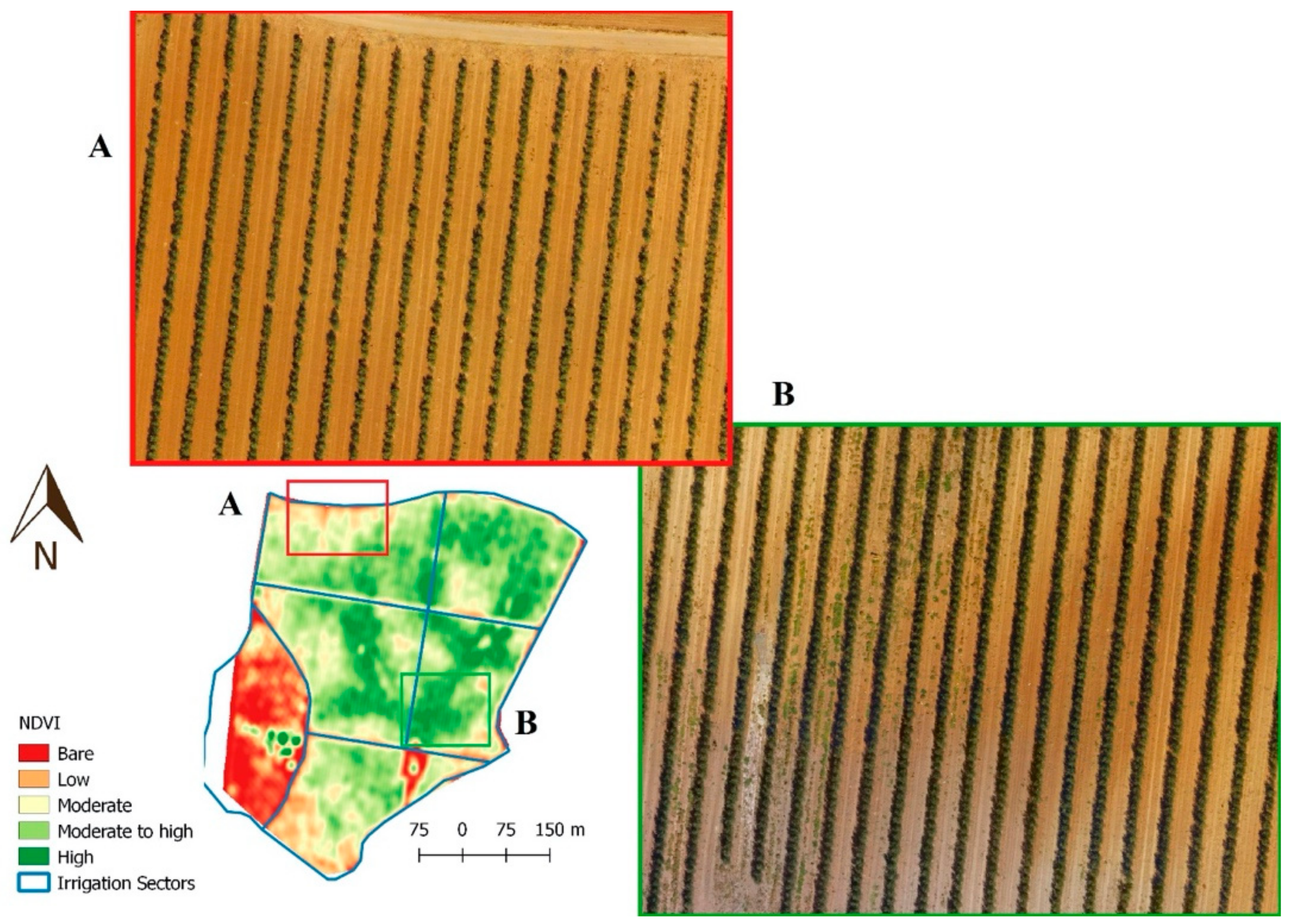
3. Results and Discussion
4. Conclusions
Author Contributions
Funding
Acknowledgments
Conflicts of Interest
References
- FAO, Statistics. Food and Agricultural Organisation, Data Base Results; Retrieved June; FAO: Rome, Italy, 2015. [Google Scholar]
- Dolgonosov, B. Knowledge production and world population dynamics. Technol. Forecast. Soc. Chang. 2016, 103, 127–141. [Google Scholar] [CrossRef]
- Foley, J.; DeFries, R.; Asner, G.; Barford, C.; Bonan, G.; Carpenter, S.; Chapin, S.; Coe, M.; Daily, G.; Gibbs, H.; et al. Global consequences of land use. Science 2005, 309, 570–574. [Google Scholar] [CrossRef] [PubMed] [Green Version]
- Guerra, C.; Metzger, M.; Maes, J.; Pinto-Correia, T. Policy impacts on regulating ecosystem services: looking at the implications of 60 years of landscape change on soil erosion prevention in a Mediterranean silvo-pastoral system. Landsc. Ecol. 2016, 31, 271–290. [Google Scholar] [CrossRef]
- Li, P.; Wu, J.; Qian, H. Regulation of secondary soil salinization in semi-arid regions: A simulation research in the Nanshantaizi area along the Silk Road, northwest China. Environ. Earth Sci. 2016, 75, 698. [Google Scholar] [CrossRef]
- Bruce McCarl, B.; Fernandez, M.; Jones, J.; Wlodarz, M. Climate Change and Food Security. Curr. Hist. 2013, 112.750, 33. [Google Scholar]
- Prosdocimi, M.; Burguet, M.; Di Primac, S.; Sofia, G.; Terold, E.; Comino, J.; Cerdà, A.; Tarolli, P. Rainfall simulation and Structure-from-Motion photogrammetry for the analysis of soil water erosion in Mediterranean vineyards. Sci. Total Environ. 2017, 574, 204–215. [Google Scholar] [CrossRef] [Green Version]
- Yang, F.; An, F.; Ma, M.; Wang, Z.; Zhou, X.; Liu, Z. Variations on Soil Salinity and Sodicity and Its Driving Factors Analysis under Microtopography in Different Hydrological Conditions. Water 2016, 8, 227. [Google Scholar] [CrossRef] [Green Version]
- Amjath-Babu, T.; Krupnik, T.; Aravindakshan, S.; Arshad, M.; Kaechele, H. Climate change and indicators of probable shifts in the consumption portfolios of dryland farmers in Sub-Saharan Africa: Implications for policy. Ecol. Indic. 2016, 67, 830–838. [Google Scholar] [CrossRef]
- Graveline, N. Economic calibrated models for water allocation in agricultural production: A review. Environ. Model. Softw. 2016, 81, 12–25. [Google Scholar] [CrossRef]
- Grundy, M.; Bryan, B.; Nolan, M.; Battaglia, M.; Dodds, S.; Connor, J.; Keating, B. Scenarios for Australian agricultural production and land use to 2050. Agric. Syst. 2016, 142, 70–83. [Google Scholar] [CrossRef]
- Zhang, Q.; Sun, Z.; Wu, F.; Deng, X. Understanding rural restructuring in China: The impact of changes in labor and capital productivity on domestic agricultural production and trade. J. Rural Stud. 2016, 47, 552–562. [Google Scholar] [CrossRef]
- McBratney, A.; Whelan, B.; Ancev, T. Future Directions of Precision Agriculture. Precis. Agric. 2005, 6, 7–23. [Google Scholar] [CrossRef]
- Rasmussen, J.; Ntakos, G.; Nielsen, J.; Svensgaard, J.; Poulsen, R.; Christensen, S. Are vegetation indices derived from consumer-grade cameras mounted on UAVs sufficiently reliable for assessing experimental plots? Eur. J. Agron. 2016, 74, 75–92. [Google Scholar] [CrossRef]
- Altieri, M.; Nicholls, C.; Henao, A.; Lana, M. Agroecology and the design of climate change-resilient farming systems. Agron. Sustain. Dev. 2015, 35, 869–890. [Google Scholar] [CrossRef] [Green Version]
- Junqueira, A.; Stomph, T.; Clementc, C.; Struik, P. Variation in soil fertility influences cycle dynamics and crop diversity in shifting cultivation systems. Agric. Ecosyst. Environ. 2016, 215, 122–132. [Google Scholar] [CrossRef]
- Mateos, L.; Araus, J. Hydrological, engineering, agronomical, breeding and physiological pathways for the effective and efficient use of water in agriculture. Agric. Water Manag. 2016, 164, 190–196. [Google Scholar] [CrossRef]
- Zhang, D.; Guo, P. Integrated agriculture water management optimization model for water saving potential analysis. Agric. Water Manag. 2016, 170, 5–19. [Google Scholar] [CrossRef]
- Bongiovanni, R.; Lowenberg-Deboer, J. Precision Agriculture and Sustainability. Precis. Agric. 2004, 5, 359–387. [Google Scholar] [CrossRef]
- Braga, R. Agricultura de Precisão: Oportunidades, Mitos, Estrangulamentos e, já Agora, Alguns Princípios base. Agroportal 2017. Available online: http://www.agroportal.pt/ (accessed on 27 February 2017).
- Lindblom, J.; Lundström, C.; Ljung, M.; Jonsson, A. Promoting sustainable intensification in precision agriculture: Review of decision support systems development and strategies. Precis. Agric. 2016, 18, 309–331. [Google Scholar] [CrossRef] [Green Version]
- Griffin, T.W.; Lowenberg-DeBoer, J. Worldwide adoption and profitability of precision agriculture: Implications for Brazil. Rev. Politica Agric. 2005, 14, 20–37. [Google Scholar]
- Loures, L.; Nunes, J.; Loópez-Pinñeiro, A.; Loures, A.; Navarro, A. Assessing Soil Edaphic Properties’ influence in Phosphorus Adsorption in Vertisols—Extremadura (Spain). Int. J. Energy Environ. 2015, 9, 53–60. [Google Scholar]
- Nunes, J.; Loures, L.; Lopez-Piñeiro, A.; Loures, A.; Vaz, E. Using GIS towards the Characterization and Soil Mapping of the Caia Irrigation Perimeter. Sustainability 2016, 8, 368. [Google Scholar] [CrossRef] [Green Version]
- FAO. Guidelines for Soil Description, 4th ed.; Food and Agriculture Organization of the United Nations: Rome, Italy, 2006. [Google Scholar]
- Yin, R. Case Study Research—Design and Methods; Sage Publications, Inc.: Thousand Oaks, CA, USA, 1994. [Google Scholar]
- Francis, M. A Case Study Method for Landscape Architecture; Landscape Architecture Foundation: Washington, DC, USA, 1999. [Google Scholar]
- Agranoff, R.; Beryl, A. The Comparative Case Study Approach in Public Administration. Res. Public Adm. 1991, 1, 203–231. [Google Scholar]
- George, A. Case study and theory development: The method of stuctured, focused comparison. In Diplomacy: New Approaches in History, Theory and Policy; Lauren, P., Ed.; Free Press: New York, NY, USA, 1979. [Google Scholar]
- Loures, L.; Panagopoulos, T. From derelict industrial areas towards multifunctional landscapes and urban renaissance. WSEAS Trans. Environ. Dev. 2007, 3, 181–188. [Google Scholar]
- Lucas, W. The Case Survey Method; RAND Corporation: Santa Monica, CA, USA, 1974. [Google Scholar]
- Castle, M.; Lubben, B.; Luck, J. Factors Influencing the Adoption of Precision Agriculture Technologies by Nebraska Producers, UNL Digital Commons. Precis. Agric. 2016, 13, 713–730. [Google Scholar]
- Lowenberg-DeBoer, J. The precision agriculture revolution making the modern farmer. Foreign Aff. 2015, 94, 105–112. [Google Scholar]
- Yost, M.; Kitchen, N.; Sudduth, K.; Sadler, E.; Drummond, S.; Volkmann, M. Long-term impact of a precision agriculture system on grain crop production. Precis. Agric. 2016, 18, 823–842. [Google Scholar] [CrossRef]
- Auernhammer, H. Precision farming- the environmental challenge. Comput. Electron. Agric. 2001, 30, 31–43. [Google Scholar] [CrossRef]
- Schimmelpfennig, D.; Ebel, R. On the Doorstep of the Information Age: Recent Adoption of Precision Agriculture; USDA: Washington, DC, USA, 2011.
- Gebbers, R.; Adamchuk, V.I. Precision agriculture and food security. Science 2010, 327, 828–831. [Google Scholar] [CrossRef]
- Esau, T.; Zaman, Q.; Groulx, D.; Corscadde, K.; Chang, Y.; Schumann, A.; Havard, P. Economic analysis for smart sprayer application in wild blueberry fields. Precis. Agric. 2016, 17, 753–765. [Google Scholar] [CrossRef]
- Loures, L.; Loures, A.; Nunes, J.; Panagopoulos, T. Landscape Valuation of Environmental Amenities throughout the Application of Direct and Indirect Methods. Sustainability 2015, 7, 794–810. [Google Scholar] [CrossRef] [Green Version]
- Ferreira, V.; Panagopoulos, T.; Andrade, R.; Guerrero, C.; Loures, L. Spatial variability of soil properties and soil erodibility in the Alqueva dam watershed, Portugal. Solid Earth 2015, 7, 301–327. [Google Scholar] [CrossRef] [Green Version]
- Loures, L.; Santos, R.; Panagopoulos, T. Urban Parks and Sustainable City Planning—The Case of Portimão, Portugal. WSEAS Trans. Environ. Dev. 2007, 3, 171–180. [Google Scholar]
- Loures, L.; Panagopoulos, T.; Burley, J. Assessing user preferences on post-industrial redevelopment. Environ. Plan. B Plan. Des. 2016, 43, 871–892. [Google Scholar] [CrossRef]
- Loures, L.; Panagopoulos, T. Reclamation of derelict industrial land in Portugal—Greening is not enough. Int. J. Sustain. Dev. Plan. 2010, 5, 343–350. [Google Scholar] [CrossRef] [Green Version]
- Loures, L. Post-industrial landscapes as drivers for urban redevelopment: Public versus expert perspectives towards the benefits and barriers of the reuse of post-industrial sites in urban areas. Habitat Int. 2015, 45, 72–81. [Google Scholar] [CrossRef]
- Loures, L.; Santos, R.; Panagopoulos, T. Urban Parks and Sustainable Development – The Case Study of Portimão City, Portugal. In Energy, Environment, Ecosystems & Sustainable Development; Markatos, N., Stamou, A., Stamatiou, E., Beltrao, J., Panagopoulos, T., Helmis, C., Stamatiou, E., Hatzopoulou, A., Antunes, M.D.C., Eds.; WSEAS Press: Athens, Greece, 2007; pp. 127–131. ISBN 978-960-8457-88-1. [Google Scholar]
- Loures, L.; Loures, A.; Nunes, J.; Panagopulos, T. The Green Revolution—Converting post- industrial sites into urban parks—A case study analysis. Int. J. Energy Environ. 2015, 9, 262–266. [Google Scholar]
- Loures, L.; Panagopoulos, T. Recovering Derelict Industrial Landscapes in Portugal: Past Interventions and Future Perspectives. In Proceedings of the International Conference on Energy, Environment, Ecosystems and Sustainable Development, Agios Nikolaos, Greece, 24–26 July 2007. [Google Scholar]


| Variables | Area (Ha) | Potential Production (15 T/ha) | Potential Income (€) | Expected Production (T) | Expected Production (€) | Balance (€) |
|---|---|---|---|---|---|---|
| 0 T/ha | 0.38 | 0 | 0 | 0 | 0 | 0 |
| 10 T/ha | 0.95 | 14.20 | 2493.1 | 9.47 | 1662.1 | −831.0 |
| 12 T/ha | 5.19 | 77.90 | 13,679.8 | 62.32 | 10,943.8 | −2736.0 |
| 14 T/ha | 13.02 | 195.24 | 34,284.7 | 182.23 | 31,999.1 | −2285.6 |
| 15 T/ha | 0.01 | 0.18 | 32.4 | 0.18 | 32.4 | 0 |
| TOTAL | 19.5 | 287.5 | 50,490.0 | 254.2 | 44,637.3 | −5852.7 |
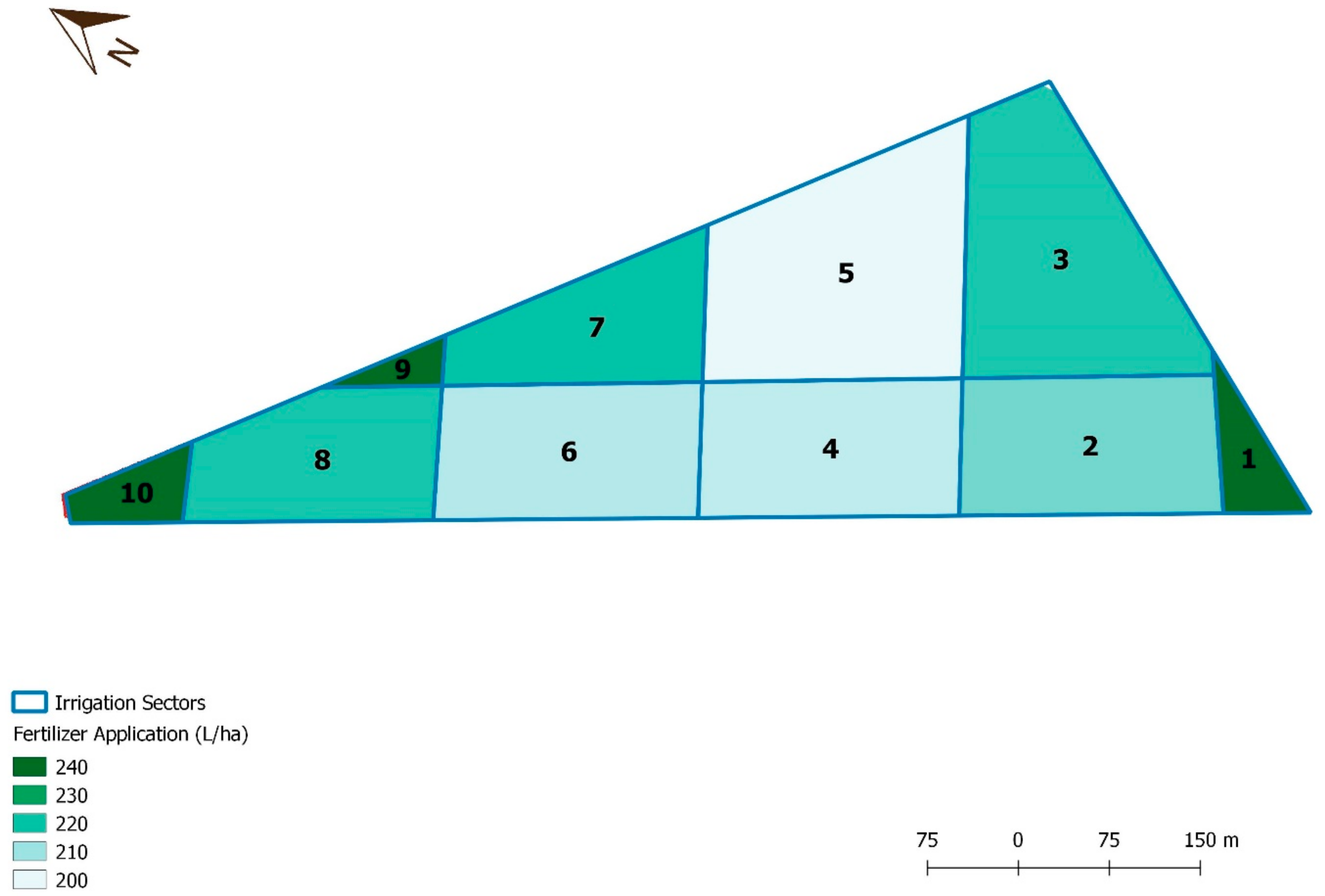
| Sector | Area (ha) | Dose N (L/ha) | Consumption (L) |
|---|---|---|---|
| Traditional application | 19.29 | 230 | 4437 |
| Proposed application | 19.29 | variable | 4216 |
| 1 | 0.48 | 240 | 116 |
| 2 | 2.42 | 220 | 532 |
| 3 | 3.36 | 230 | 774 |
| 4 | 2.42 | 210 | 508 |
| 5 | 3.7 | 200 | 739 |
| 6 | 2.41 | 210 | 506 |
| 7 | 1.82 | 230 | 419 |
| 8 | 2.03 | 230 | 466 |
| 9 | 0.21 | 240 | 50 |
| 10 | 0.44 | 240 | 105 |
© 2020 by the authors. Licensee MDPI, Basel, Switzerland. This article is an open access article distributed under the terms and conditions of the Creative Commons Attribution (CC BY) license (http://creativecommons.org/licenses/by/4.0/).
Share and Cite
Loures, L.; Chamizo, A.; Ferreira, P.; Loures, A.; Castanho, R.; Panagopoulos, T. Assessing the Effectiveness of Precision Agriculture Management Systems in Mediterranean Small Farms. Sustainability 2020, 12, 3765. https://doi.org/10.3390/su12093765
Loures L, Chamizo A, Ferreira P, Loures A, Castanho R, Panagopoulos T. Assessing the Effectiveness of Precision Agriculture Management Systems in Mediterranean Small Farms. Sustainability. 2020; 12(9):3765. https://doi.org/10.3390/su12093765
Chicago/Turabian StyleLoures, Luís, Alejandro Chamizo, Paulo Ferreira, Ana Loures, Rui Castanho, and Thomas Panagopoulos. 2020. "Assessing the Effectiveness of Precision Agriculture Management Systems in Mediterranean Small Farms" Sustainability 12, no. 9: 3765. https://doi.org/10.3390/su12093765