Article

Prioritization of Cartagena Coastal Military Batteries to Transform Them into Scientific, Tourist and Cultural Places of Interest: A GIS-MCDM Approach

by
J. M. Sánchez-Lozano
*,
F. J. Salmerón-Vera
and
C. Ros-Casajús
Centro Universitario de la Defensa de San Javier, Academia General del Aire, Universidad Politécnica de Cartagena (UPCT), 30720 Murcia, Spain
*
Author to whom correspondence should be addressed.
Sustainability 2020, 12(23), 9908; https://doi.org/10.3390/su12239908
Submission received: 3 November 2020 / Revised: 24 November 2020 / Accepted: 24 November 2020 / Published: 26 November 2020

Abstract

:
This study presents a combination of multi-criteria decision-making (MCDM) methodologies with geographic information systems (GIS) to carry out a prioritization of obsolete military coastal batteries with the aim of transforming them into touristic, scientific, and cultural places of interest. The study area is located in the Municipality of Cartagena, in Southeast Spain. Such a prioritization requires taking into account transport criteria (distance to roads or train stations), infrastructure criteria (distance to electrical grids or distance to water tanks), touristic or scientific criteria (distance to towns, beaches, archaeological sites, assets of cultural interest, etc.), and orography criteria (area, altitude, and slope of each battery). Therefore, this decision problem involves a set of alternatives (coastal military batteries) to be prioritized based on a group of criteria that should be considered. To tackle this, GIS software is used to provide the attribute table of alternatives and criteria (decision matrix), and the proposed decision problem is solved through a combination of MCDM methodologies based on the Technique for Order of Preference by Similarity to Ideal Solution (TOPSIS) and Analytic Hierarchy Process (AHP) techniques. The AHP approach is applied to determine the weights of the criteria whilst the TOPSIS method provides a ranking of alternatives in order to obtain a prioritization.

1. Introduction

In the 15th century, the navies of many nations progressed to such a level of efficiency that they could attack cities from the sea. This fact, among others, forced the need for innovation in coastal artillery. Sets of coastal military fortifications began to be articulated to protect national territories from possible naval attacks, creating the first military coastal batteries. Some of the areas chosen to strengthen their security were territories such as Africa, the Caribbean, or Spain, for instance on the Ferrol coast [1].
In Spain, new combat modes motivated the inclusion of advanced artillery and the creation of new military coastal batteries in the 19th and 20th centuries. These batteries were located in the main naval ports, including Vigo, Barcelona, Cartagena, the Strait of Gibraltar, Ceuta, and Mallorca [2].
The city of Cartagena, due to its strategic location and excellent orography, was declared the great naval base in 1913. As a consequence of that, the coastal area of Cartagena had 25 operational coastal batteries available at the end of the Spanish Civil War [3]. After the Second World War, new weapons progress was obtained, thus rendering such batteries obsolete.
Currently, although said batteries were declared assets of cultural interest by law 16/1985 from 25 June of Spanish Heritage [4], the reality is that most of them are derelict or with lack of use. Figure 1 shows an image of one of the mentioned batteries. As a result of that, some current initiatives have been proposed to recover the batteries of Cartagena and convert them into touristic, scientific, and cultural places of interest.
The preservation of such batteries can bring great benefits to the city. In the first place, it is worth mentioning that the coastal batteries are vestiges of very important times in the city (17th, 18th, 19th, and 20th centuries), which was affected by multiple conflicts and wars [5]. This makes conserving these batteries of great importance from a cultural perspective. The second area is tourism, closely related to the cultural sphere but also to the conservation of nature. The privileged location of a large part of these batteries, which are located in protected natural environments, makes them serve as an attraction for sustainable tourism, linking the conservation of heritage with the conservation of the environment. The third and last area would be the scientific one, since many of these properly conditioned batteries could be used as research centers in different fields.
In fact, the nexus between tourism and the reconstruction and conservation of the historical legacy of the city of Cartagena was already highlighted in the last edition of the International Tourism Fair in Madrid (FITUR). There, its natural and cultural heritage, its archaeological legacy, and its historical footprint, which various civilizations have left during its 3000 years of antiquity, stood out [6].
In addition, the city of Cartagena has recently presented its candidature to be declared a World Heritage Site by UNESCO and, precisely, this candidature is based on the set of coastal military fortifications of the municipality for its universal and exceptional value [7,8]. Such an initiative aims to place the City of Cartagena on the international map of tourism and culture.
The protection and valuation of military heritage is not always straightforward and requires a favorable legislative framework by governments [9]. Even in some countries, such as Switzerland, military infrastructures have been reassigned to other state functions or even redeveloped into civilian shelters [10]. Some Spanish military fortifications present similar conditions as, for example, in the case of the city of Cádiz. There, some studies have already been carried out with the aim of addressing marketing strategies in the planning and management of military cultural heritage [11] and analyzing the future of its fortifications [12]. However, apart from the analysis of the city of Cádiz, similar studies have not been carried out in other Spanish coastal cities; perhaps as a result of the conflicts between tourism development vs. conservation and enhancement of natural heritage, which make it difficult to materialize these initiatives [13].
Furthermore, in the specific case of the city of Cartagena, because of the high number of batteries on the Cartagena coast, it is not easy to prioritize one over another to carry out conversion and restoration processes. In addition, when it comes to addressing that prioritization, multiple criteria, such as the number of visitors, ease of access, or proximity to electrical and water resources, to mention just some of them, should be taken into consideration. Precisely for that reason, the combination of software tools such as geographic information systems (GIS) with decision theory techniques like multi-criteria decision-making (MCDM) methodologies can be very useful and appropriate.
On the one hand, GIS enables the possibility of performing the editing, storage, and display of spatially referenced information, whilst on the other hand, MCDM methods have the capacity to address decision problems composed by a set of alternatives to evaluate based on a large number of criteria that have influence in the assessment process.
In the last decade, the GIS–MCDM combination has been applied to solve numerous studies in fields and areas as diverse as ecotourism in Thailand [14], strategic environmental decisions in Australia [15], renewable energy in Spain [16,17], hydrology in Saudi Arabia [18], industrial wastewater management in China [19], fisheries management in Portugal [20], and even the optimal location of landfills on a global scale [21].
Although the GIS literature provides a high number of applications using different MCDM methodologies, such as ELECTRE [22], PROMETHEE [23], OWA [24], and VIKOR [25], two MCDM methods stand out above the rest due to their simplicity and operational ease: the Analytic Hierarchy Process (AHP) [26] and the Technique for Order of Preference by Similarity to Ideal Solution (TOPSIS) [27].
One of the main features of the AHP methodology is that it is able to structure the decision problem into a hierarchy of goal, criteria, and alternatives. Due to that fact, establishing a paired comparison of criteria and applying matrix products is intuitive and easy to perform. The strong point of the TOPSIS method lies in its versatility to work with a high number of criteria that can present different natures or units. Such a technique enables the assessment of alternatives based on a set of criteria. To do that, the Euclidean distance and the relative closeness to an ideal solution are applied.
For all of the above reasons, this study presents a GIS–MCDM combination methodology to carry out a prioritization of obsolete military coastal batteries with the aim of them being reconverted into touristic, scientific, and cultural places of interest. The study area is located in the Municipality of Cartagena, Southeast Spain. A GIS software is used to provide the attribute table of alternatives and criteria (decision matrix), and the proposed decision problem is solved through a combination of MCDM methodologies based on the TOPSIS and AHP techniques (Figure 2). The AHP approach is applied to determine the weights of the criteria whilst the TOPSIS method provides a ranking of alternatives in order to obtain a prioritization.
The rest of the paper is divided into three parts: the applied methodology (AHP and TOPSIS techniques) is described in the first part; in the second part, both the proposed decision problem and the use of GIS software are expounded, studied, and discussed; and the final section provides the principal conclusions of this study.

2. Materials and Methods

2.1. Analytic Hierarchy Process (AHP)

The Analytic Hierarchy Process (AHP) methodology, first contributed in [26], is an intuitive and effective MCDM model to address decision problems composed by a set of alternatives and criteria. It is worth noting that AHP presents three main features:
  • The decision problem is modeled as a hierarchy composed of different elements: objective to achieve (upper level), criteria and subcriteria (intermediate levels), and finally the alternatives (lower level).
  • Comparisons between pairs of elements at each level of the hierarchy must be carried out, depending on the importance of each one with respect to the element at the top level.
  • The global contribution of each alternative to the main objective or goal through an additive type aggregation is provided.
Although AHP provides the impact of each one of the alternatives on the overall goal of the hierarchy, in this study we shall only apply such a methodology for the purpose of obtaining the weights of the criteria and subcriteria. Next, the working of AHP is summarized.
The starting point consists in the preparation of the comparison matrix, which is obtained through the quantified judgments provided by experts. The elements of the n-order matrix (C) correspond to comparisons between the criteria pair (Ci, Cj):
Sustainability 12 09908 i001
Its main diagonal (c11, c22, …, cnn) contains 1s since the same criteria are compared with each other. The rest of the values, for example c13, signify the relative evaluation of criterion C1 with respect to criterion C3 (c13w1/w3). Therefore, the statements of the AHP methodology are as follows:
  • cij ≈ (wi/wj), for all i, j = 1, 2, …, n.
  • cii = 1, for all i = 1, 2, …, n.
  • If cij = α ≠ 0, then cji = 1/α, for all i = 1, 2, …, n.
  • If the criterion Ci becomes more relevant than Cj, then cij ≅ (wi/wj) > 1.
It should be observed that the rules above verify the properties of reciprocity and homogeneity of C, so we only need the experts to provide value judgments to complete the upper triangular matrix. To determine the relative importance of the criteria, the fundamental scale proposed by Saaty is applied [28]. Therefore, due to the order of the matrix C, it is necessary to carry out the following number of judgments L:
L = n ( n 1 ) 2
Through the maximum eigenvalue λmax of C, AHP calculates the eigenvector, which provides the vector of weights. Furthermore, the eigenvector allows us to analyze the consistency of the value judgments given by the experts through the comparison matrices. The consistency index (CI) is defined as CI = (λmaxn)/(n − 1), so that the closer the value λmax is to the order of the matrix C, the greater the consistency of the judgments. Saaty provides the consistency ratio CR = CI/RI, where RI means the random index, which is defined as the average random consistency index obtained by simulating 100,000 randomly generated reciprocal matrices using the Saaty scale (see Table 1) [29]. Thus, if CR < 0.1, then the consistency of the comparison matrix is accepted and therefore the eigenvector of weights is admitted as valid.

2.2. TOPSIS Method

The Technique for Order Performance by Similarity to Ideal Solution, known as TOPSIS, was contributed by [27,31] and, just like the AHP methodology, is one of the most widespread and applied MCDM procedures [32,33]. This technique introduces the concept of the ideal alternative, defined as the solution that presents, on the one hand, the shortest distance to the positive ideal solution (PIS—positive ideal solution), and on the other, the distance furthest from the negative ideal solution (NIS).
Next, we shall sketch the main stages for the TOPSIS algorithm.
Step 1: Establishing a performance matrix
Let Ai (i = 1, …, m) be the alternatives that will be evaluated by the criteria Cj (j = 1, …, n), leading to a decision matrix like the next one (see Table 2):
where xij refers to the performance score of alternative Ai with respect to criteria Cj, and W = [w1, w2, , wn] denotes the weight vector associated with these criteria.
Step 2: Normalizing the decision matrix
This stage is to obtain the corresponding normalized decision matrix. To deal with it, the value of each criterion is divided by its norm, namely,
n i j = x i j i = 1 m x i j 2         j = 1 , , n       i = 1 , , m  
so the scale becomes the same for each criterion.
Step 3: Calculating the weighted normalized decision matrix
It is worth mentioning that the elements of the weighted normalized decision matrix V are given by the following expression:
v i j = w i j n i j ,       j = 1 , , n ,   i = 1 , ,   m
where the wjs are such that 1 = j = 1 n w j . This provides the weight of the jth attribute and will be calculated via the AHP methodology (see Section 2.1).
Step 4: Determining the positive ideal solution (PIS) and the negative ideal solution (NIS)
Let A+ denote the positive ideal value set, which contains the best performance scores, and also with A being the negative ideal value set, containing the worst performance scores. Mathematically,
A + = { v 1 + , ,   v n + } = { m a x i { v i j , j J } ,   i = 1 , 2 , ,   m   if criterion is to maximize or m i n i { v i j , j J } ,   i = 1 , 2 , ,   m   if criterion is to minimize A = { v 1 , ,   v n } = { m i n i { v i j , j J } ,   i = 1 , 2 , ,   m   if criterion is to maximize or m a x i { v i j , j J } ,   i = 1 , 2 , ,   m   if criterion is to minimize
where the index J is associated with the criteria that give profits or benefits, and the index J′ is associated with those indicating costs or losses.
Step 5: Calculating the separation measures
To calculate the separation of each alternative from the PIS (with respect to the NIS), let us consider the following expressions:
d i + = { j = 1 n ( v i j v j + ) 2 } 1 2 ,   i = 1 , ,   m
d i = { j = 1 n ( v i j v j ) 2 } 1 2 ,   i = 1 , ,   m
Step 6: Calculating the relative closeness to the ideal solution
Firstly, let us calculate the ranking score Ri as follows:
R i = d i d i + + d i ,   i = 1 , , m
Notice that all the Ri lie in (0,1). Accordingly, the closer to 1 the Ri are, the higher the priority of the ith alternative is.
Step 7: Ranking the preference order
In this stage, we shall sort the best alternatives according to the ranking scores Ri in descending order. It is worth noting that in this case, the TOPSIS approach will be applied to prioritize all the alternatives, i.e., the coastal military batteries located in the Municipality of Cartagena.

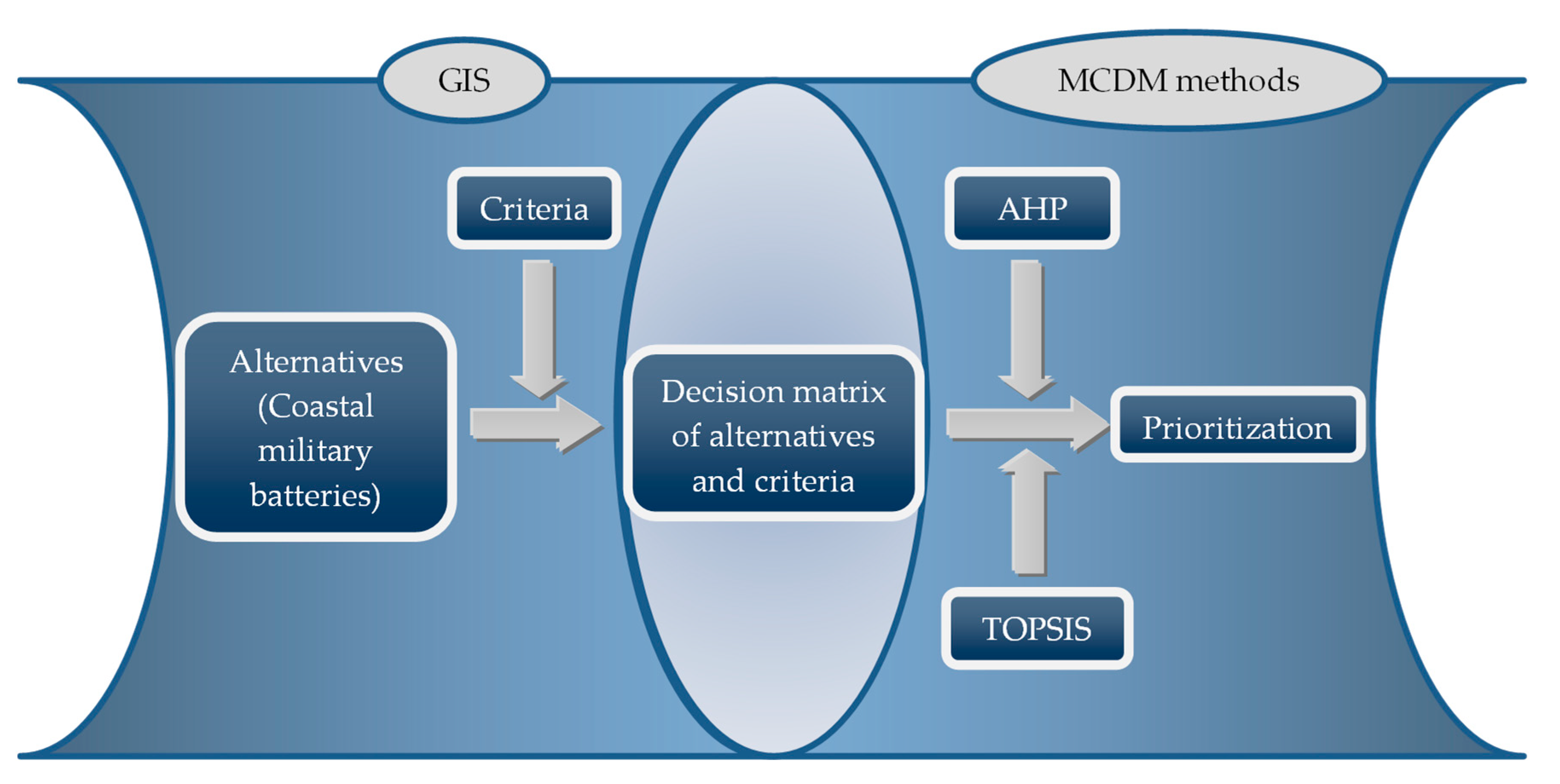
3. Decision Problem: Prioritization of Coastal Military Batteries to Transform into Scientific, Touristic, and Cultural Places of Interest
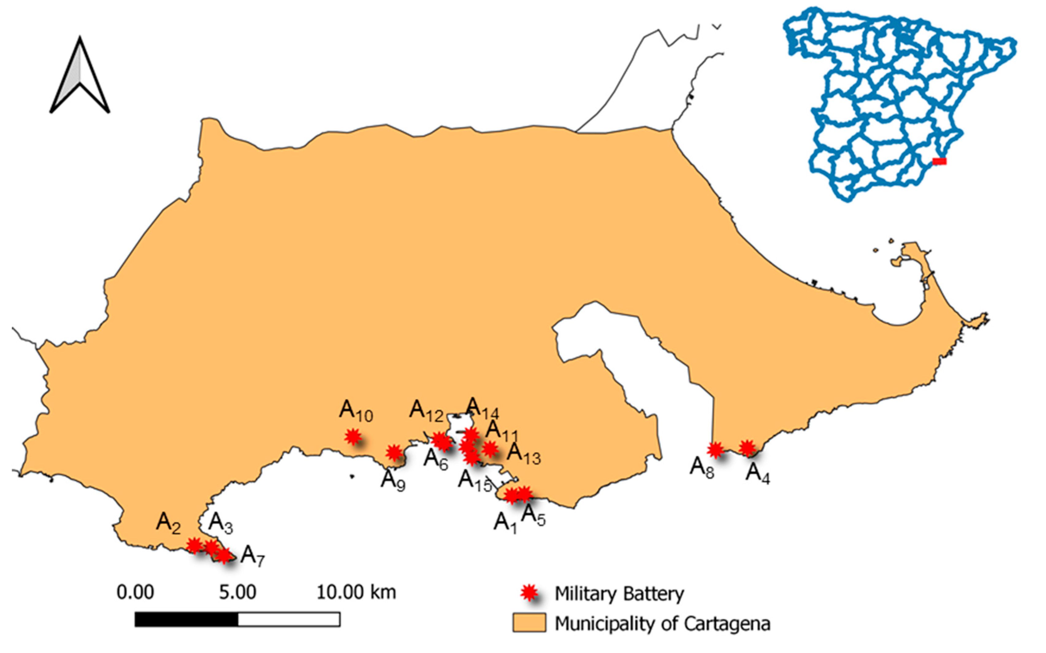
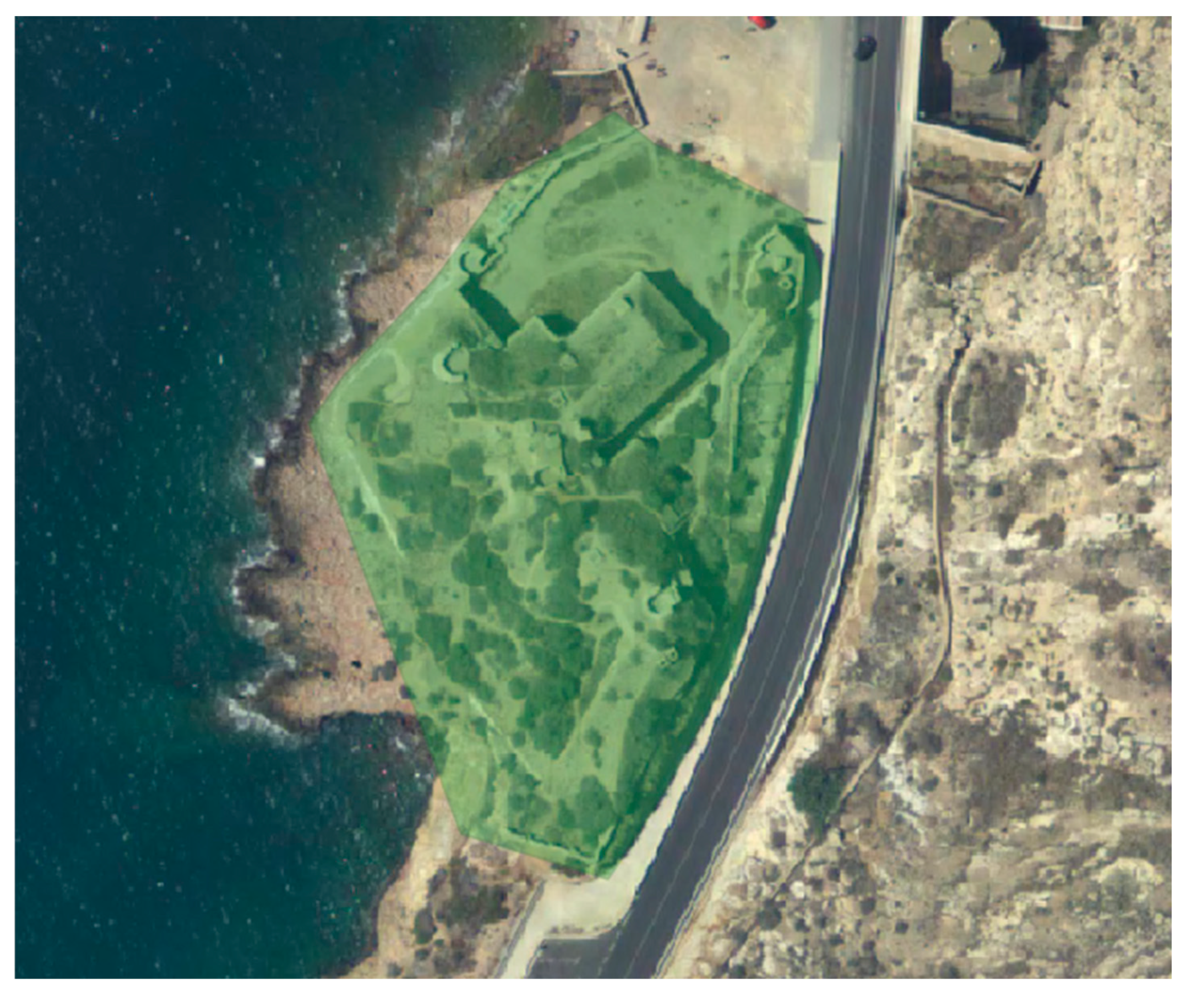
3.1. Area of Study

The city of Cartagena is located in the Region of Murcia, on the Mediterranean coast in southeastern Spain. Its origins go back to 227 B.C., when it was founded by the Carthaginians. It had its maximum splendor during the Roman Empire, and was known as Carthago Nova. Apart from the confluence of civilizations, which have provided a high number of landmarks such as its Roman Theatre and the abundance of Phoenician, Roman, Byzantine, and Moorish remains, one of the main features of Cartagena is its coveted defensive port, among the most important in the Western Mediterranean.
Due to its excellent orography, a set of artillery groups composed of batteries with large-caliber artillery pieces were distributed around strategic points on the coast of Cartagena in the 19th and 20th centuries. Those batteries played an important role until the end of the Spanish Civil War. After the Second World War, new weapons development was achieved and such batteries became obsolete. Although some of them still have the cannons that protected the city back then, nowadays most of these military batteries lie derelict or in ruins. As a consequence of their historical heritage and importance, Spanish and regional legislation is attempting to preserve and protected the main batteries, which make up a total of 15 batteries (see Figure 3). In order to do so, some initiatives from the Cartagena administration have sought to convert these coastal military batteries into interesting and attractive places. Their reconstruction and preservation would not only allow for an increase in the environmental offer or contact with nature to the inhabitants of Cartagena, but would also offer an additional attraction to the touristic offer of the city, which received in 2019 a total of 160,870 visitors from countries such as the United Kingdom, the United States, Germany, and France [34].
However, since such a transformation implies a high investment cost, it is advisable to prioritize the order in which these batteries should be acted upon. To do this, it is necessary to take into account transport criteria, the distance to roads or train stations; infrastructure criteria, the distance to electrical grids or the distance to water tanks or natural water sources; touristic or scientific criteria, the distance to towns, beaches, archaeological sites, assets of cultural interest, etc.; and orography criteria such as the area, altitude, and slope of each battery. Therefore, this decision problem involves a set of alternatives (coastal military batteries) to be evaluated based on a group of criteria that should be considered. The description of both is presented in the following sections.

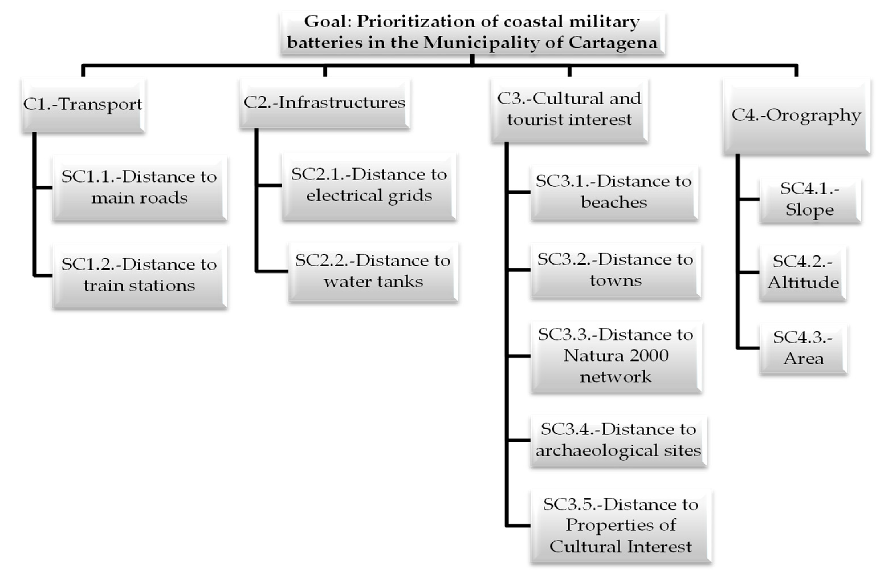
3.2. Brief Description of the Alternatives and Criteria

As a continuation to the abovementioned information, the alternatives of this study correspond to the main military batteries of the Municipality of Cartagena, making a total of 15 batteries.
The locations of the alternatives mentioned above are shown in Figure 3. These coastal military batteries cover a wide range of ages. The oldest one is the San Leandro battery (A15), which dates back to 1741. All the batteries have been disarticulated, with the last being the Aguilones and Parajola batteries (A1 and A9, respectively). Some of them, such as the Castillitos, Cenizas, and Jorel batteries (A3, A4, and A7, respectively), still have their cannons. Most of them present very varied architectural styles, such as a neoclassical style in the Jorel battery (A7), a modernist style inspired by Egyptian art in the Parajola battery (A9), and even avant-garde lines reminiscent of Gaudí’s work in the Roldán battery (A10). With the exception of the San Fulgencio battery (A12), the rest have been designated as assets of cultural interest. Their names and main features are described as follows:
Alternative A1—Aguilones Battery: It is located at the southern end of the Ensenada de Escombreras. It had a decisive intervention during the Spanish Civil War. The last time it was operational was in November 1992. This battery was disjointed in 1994.
Alternative A2—Atalayón Battery: Its cannons were mounted between 1926 and 1933, before the beginning of the Spanish Civil War. It is situated beside the Tiñoso Cape. The anti-aircraft defense of that cape was its main mission during the Civil War.
Alternative A3—Castillitos Battery: It is located on the side of the Tiñoso Cape. From this position, a wide panoramic view from Los Aguilones (Escombreras) to Gata Cape can be appreciated. It is currently out of service, but remains armed with two impressive Vickers cannons. It crossed fire with its twin, the Cenizas battery, preventing enemy ships from bombarding the Cartagena Naval Base.
Alternative A4—Cenizas Battery: It was built for the Cartagena Artillery Regiment. Its fortification project on the Cabezo de Cenizas mountain ended in December 1932. It covered a wide maritime sector, avoiding bombardments from the Cartagena Naval Base less than 35 km away. Although this battery fired its last shots in 1981, it still has the cannons that protected it back in the day.
Alternative A5—Conejos Battery: Its position is close to the Aguilones Battery. This battery was built during the Artillery Program of 1926. It had four cannons that were framed in the Anti-Aircraft Group of the Artillery Regiment of Cartagena in 1940. Two decades later, it carried out its last real shooting exercise. This battery was disjointed in 1965.
Alternative A6—Fajardo Battery: It is situated in the southeast of the Mount of Galeras on a small peninsula 94 m in altitude. That position, which closes the mouth of the Port of Cartagena on the west side, has played an important role in the defense of the naval base, housing several cannons over the years. Currently all its cannons are disjointed.
Alternative A7—Jorel Battery: It is located at the very tip of the Tiñoso Cape, 218 m above sea level. It was built in 1929 and some of its facades present a neoclassical style. Its main feature is its shooting positions, which were fortified semi-buried to camouflage with the landscape. It is currently out of service, although it remains armed with three cannons.
Alternative A8—Chapa Battery: This battery is situated to the east of Portmán Bay. It was built during the Artillery Program of 1926 between the years 1929 and 1931. It had great relevance in different events that happened in the area during the Spanish Civil War. It carried out its last real fire action on 11 May 1992.
Alternative A9—Parajola Battery: Its position, with an average altitude of 165 m, is close to the Roldán Battery. Its panoramic view extends from Tiñoso Cape to Escombreras Bay. Its facade is in a modernist style inspired by Egyptian art. It is known for having been the battery that sank the Castillo de Olite ship during the Civil War on 7 March, 1939. It is currently dismantled and has been out of service since 1994.
Alternative A10—Roldán Battery: It is located at the top of Roldán mountain, with an altitude of 485 m. This anti-aircraft battery was built between 1928 and 1929. Its architecture, inspired by avant-garde lines, is reminiscent of Gaudí’s work and constitutes one of the most unique buildings built for the defense of the Cartagena Naval Base. From its altitude, a vast 360° sector was dominated, widely encompassing all the potential trajectories of enemy aircraft. It carried out its last fire exercise in 1959.
Alternative A11—San Isidoro, Santa Florentina, and Santa Ana batteries: These batteries will be considered a single alternative due to the proximity between them. The main characteristic of the batteries of San Isidoro and Santa Florentina is their privileged situation to dominate the inlet of the Port of Cartagena. The battery of Santa Ana is close to the previous two batteries and its origin comes from the Fort of Santa Ana from the beginning of the 18th century, which was rebuilt into a castle. These batteries were disjointed in 1956.
Alternative A12—San Fulgencio Battery: It is located at an altitude of 27 m above the hill that connects with the Mounts Galeras and Fajardo. It had the main mission of preventing the bombings of the Arsenal of Cartagena and the landing of enemy warships. It was reformed in 1870 and was disjointed before the Spanish Civil War.
Alternative A13—General Ordóñez and San Julian Battery: It came into service in 1909. Due to its elevated situation of 281 m, it offers an excellent panoramic view of the Escombreras cove, the port, the military arsenal, and the Campo de Cartagena. Its four cannons were definitively dismantled in 1960.
Alternative A14—San Leandro Battery: It is located very close to the Port of Cartagena. Due to its low altitude, its main mission was to cooperate with the rest of the batteries in defending the port inlet, trying to prevent the entry of enemy warships. This battery dates back to 1741.
Alternative A15—Trincabotijas Battery: This battery is located at the southern end of Cortina Cove, with an altitude of 58 m. It is the oldest coastal battery in Cartagena since it was built in 1672. This battery underwent several transformations over the years and was dismantled at the end of the Spanish Civil War.
After carrying out the description of the alternatives, it is necessary to mention all the criteria and subcriteria that have influence in this decision problem. The variables (criteria and subcriteria) selected in this study were obtained through an advisory group composed of six experts from different fields, specifically with two PhD experts in tourism and environmental management, a faculty professor expert in such disciplines, a regional politician, a municipal land-use planning engineer, and a researcher with more than 10 years of experience in the reconstruction of historic buildings. In short, the criteria (C) and subcriteria (SC) of this case of study are shown through its hierarchy structure (Figure 4), which constitutes the starting point for the application of the AHP methodology.

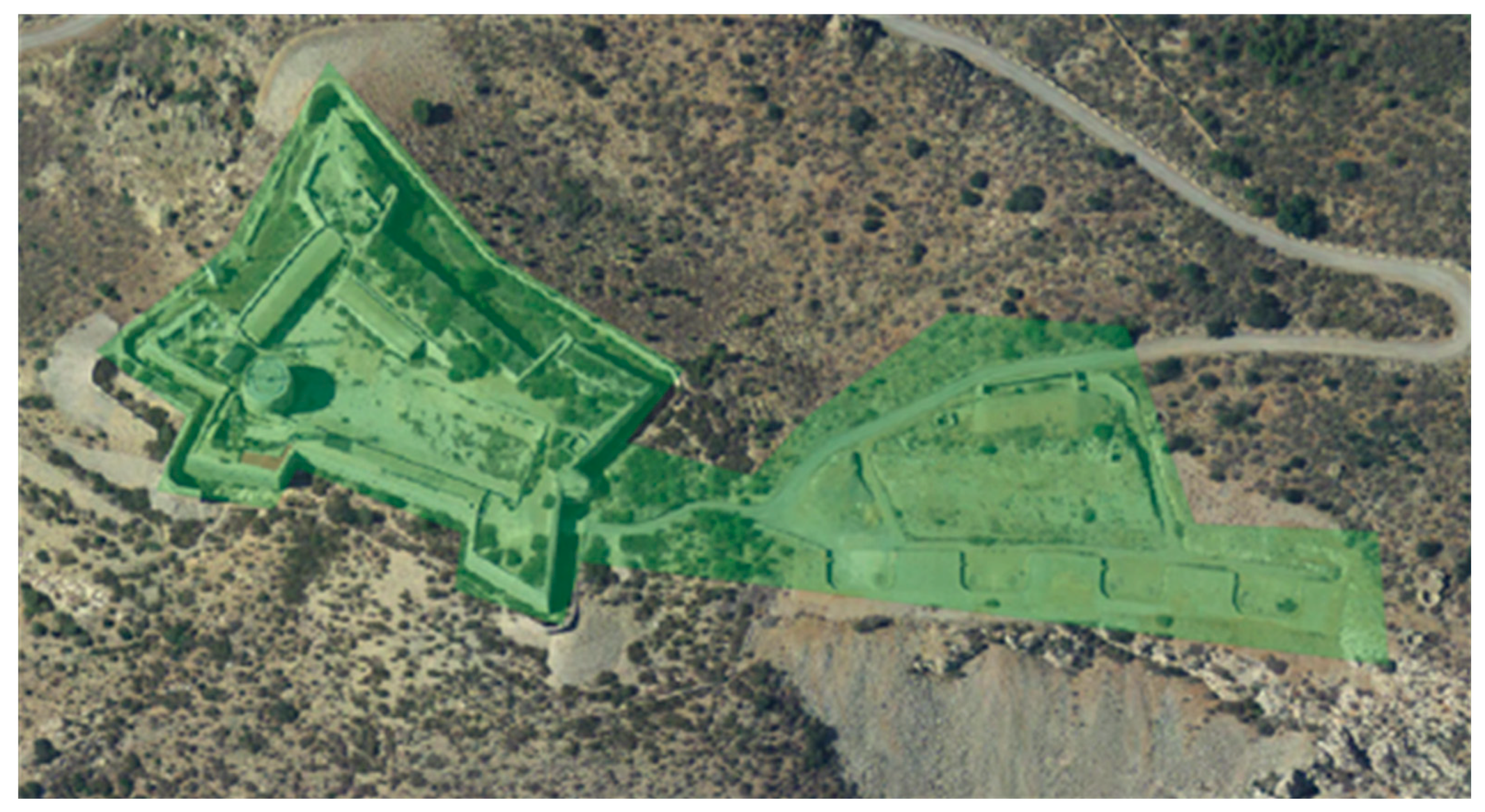
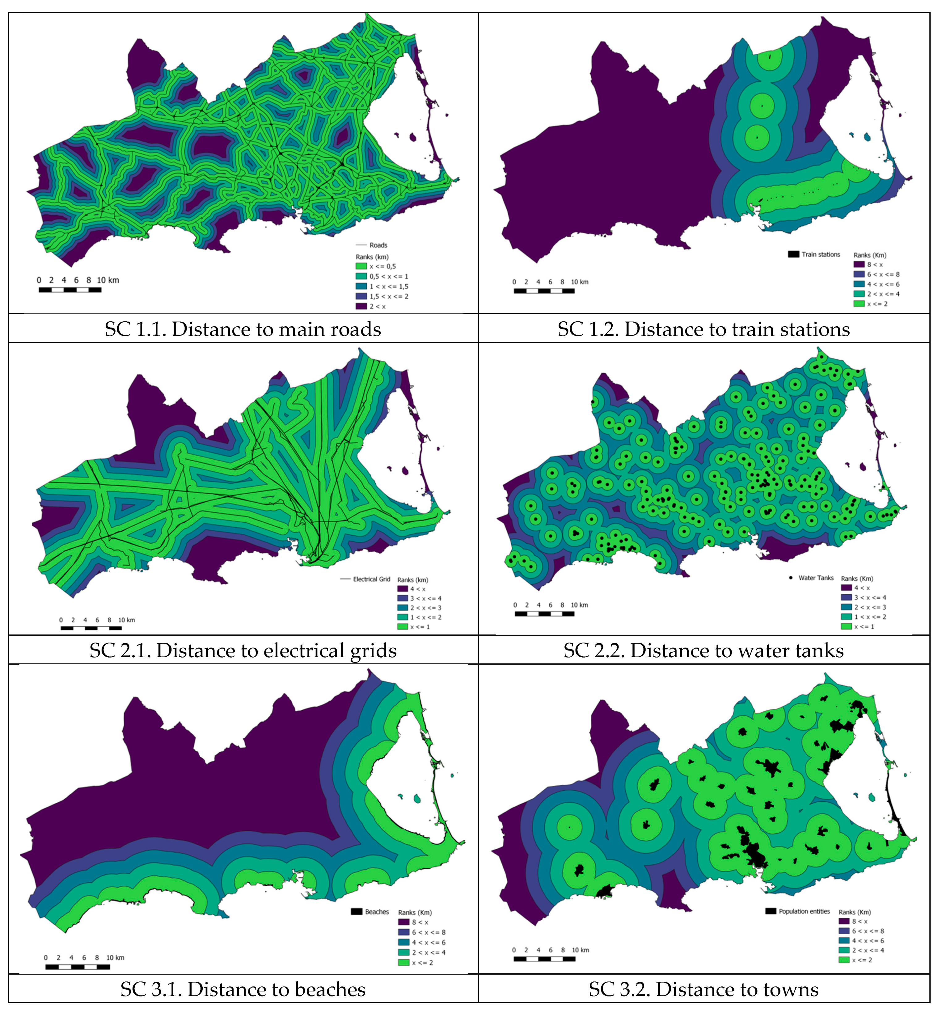
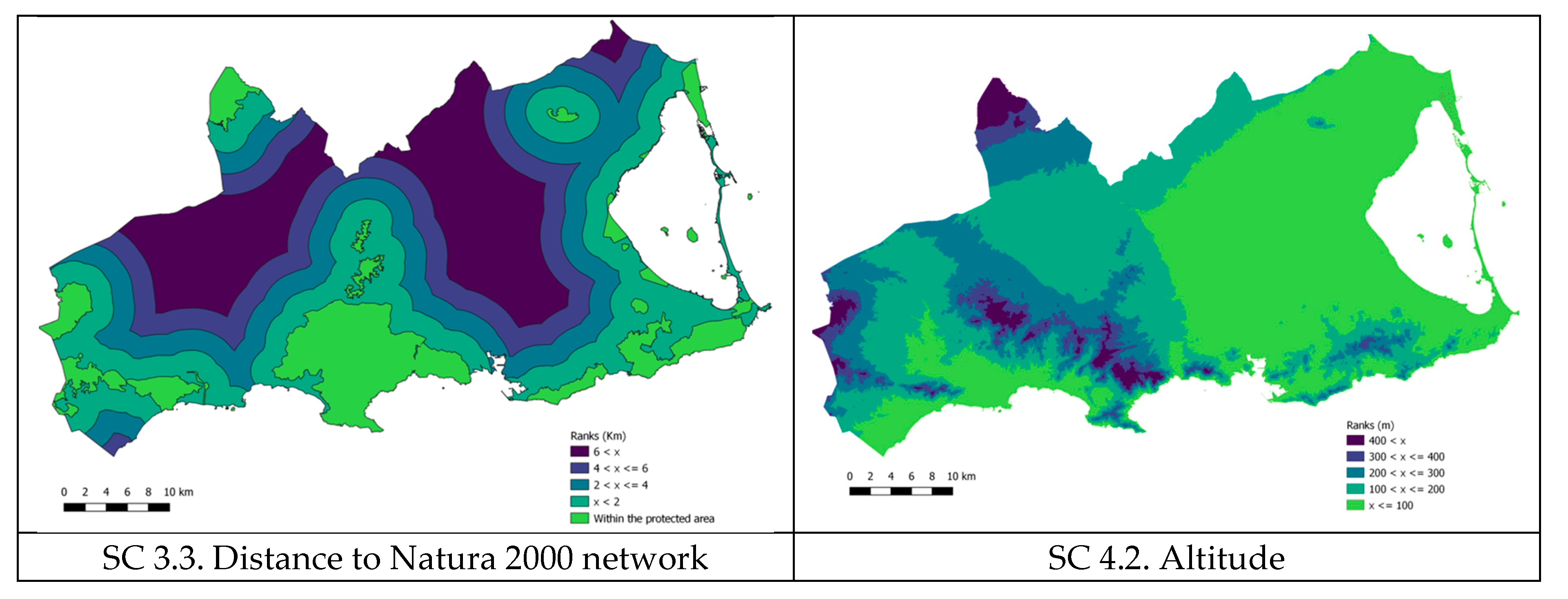
3.3. Obtaining the Decision Matrix through GIS Software

Once all the alternatives, criteria, and subcriteria are defined, the GIS software must be applied to obtain the database, which constitutes the decision matrix of this study. To do that and due to its free access, the software QGIS [35] was chosen. The starting point to the application of the GIS software consists of the generation of the subcriteria thematic layers. To do so, it is necessary to extract the digital cartographical information. Said information was obtained through several institutions, regional administrations, and government departments such as the Ministry for the Ecological Transition and the Demographic Challenge, National Geographic Information Center, General Directorate of Coasts of the Ministry of Environment, Information System on Land Occupation of Spain, Department of Public Works, and Planning of the Region of Murcia, etc.
From that point, the different commands and editing tools of filter, slope, cut, join, etc., of QGIS enabled the generation of eight subcriteria thematic layers (Figure 5).
The thematic layers of subcriteria 3.4 and 3.5, distance to archaeological sites and properties of cultural interest, respectively, were obtained by elaborating five circular buffers of a width of 2 km each around the points of the centroid layer of the surfaces of the alternatives. An example of this procedure for alternative A4 (Cenizas Battery) is shown in Figure 6.
The mean slope of the accesses for each alternative (subcriteria 4.1) was calculated with the QGIS software using the thematic slope layer from the National Geographic Institute and the routes from the batteries to the points where vehicle access is possible (Figure 7).
Subsequently, the information corresponding to the last subcriterion (SC4.3.—Area) was established using the “area” command of the QGIS software through the Cadastral service of the Municipality of Cartagena. Finally, through the intersection command of the GIS software, the decision matrix of the alternatives and criteria was obtained (Table 3).

3.4. Determination of the Weights of the Criteria and Subcriteria

To determine the weights of the criteria, the advisory group mentioned above took part. The experts filled in a questionnaire similar to that carried out in [36]; it is based on the AHP methodology to generate the comparison matrices of the criteria and subcriteria. The paired comparison matrix for the global criteria carried out by Expert 1 is shown as an example (Table 4).
It is necessary to unify the weights of the criteria provided by the experts in the latest stage of prioritization of alternatives in order to use them. To achieve this, a homogeneous aggregation (considering that all experts are equally important in the decision problem) by the arithmetic average was carried out. The weights of each criterion are shown in Table 5.
To verify the consistency of the AHP method, the consistency ratio (CR) was calculated. This value was less than 0.1, so it was not necessary to review the judgments of the experts.

4. Results and Discussion. Prioritization of the Alternatives

Once the set of criteria was selected and the weights of the criteria obtained (Table 4), the TOPSIS method provided a measure of the effect produced by each alternative with respect to each subcriteria. To do that, the starting point was the decision matrix (Table 3). After applying all the steps of this methodology, the relative closeness to the ideal solution (Ri) and a ranking of alternatives was obtained. This ranking allows the decision maker to show the prioritization of the different alternatives (Table 6).
Observing the values of the decision matrix (Table 3) and considering the criteria with the highest importance coefficient (Table 5), it could be thought that the best alternative is A1 Aguilones Battery as a consequence of its greater proximity to the main roads and electrical grids. However, the battery located in the first position (see Table 6) is alternative A14 San Leandro Battery (Figure 8). That fact proves the compensatory nature of the TOPSIS methodology. It should be mentioned that this battery is not only the closest to Cartagena city, but is also the oldest. Its proximity to Cartagena makes it very attractive to other city attractions. Furthermore, this proximity allows it to make use of available roads, electrical grids, and water supply, favoring any reconstruction process. The advisory group was asked for an appraisal in regard to the obtained ranking based on the GIS–AHP–TOPSIS combination. As a result, the group of experts confirmed the adequacy of such a ranking. In fact, they suggested a possible reconversion for the best-valued alternative (San Leandro Battery). They indicated that, for example, a parador-museum could increase the hotel offer and the tourist attraction, providing, in turn, a museum that would allow the history of the coastal military fortifications of Cartagena to be explained.
The next four alternatives, very close to each other, are the General Ordóñez and San Julian, La Chapa, Aguilones, and Conejos batteries (A13, A8, A1, and A5, respectively). It should also be noted that the alternatives classified in the last positions are the Castillitos and Jorel batteries (A3 and A7, respectively). These batteries are not only very far from the city, but also the difficulties in their access generate a significant disadvantage to undertaking reconstruction work.

5. Conclusions

Since in the restoration or preservation of historic buildings such as coastal batteries many stakeholders are involved (local administrations, legal owners, entrepreneurs, etc.), studies of this nature are clear examples of how a problem of prioritizing alternatives, of interest in preserving the heritage of any city, can be addressed.
After carrying out this study, it was verified that the combination of GIS with multi-criteria decision-making methodologies such as the AHP and TOPSIS methods allows us to solve complex problems of prioritization of alternatives. While the GIS provides the database in the form of a decision matrix of alternatives and criteria, multi-criteria methods enable the alternatives (coastal military batteries in the municipality of Cartagena) to be evaluated and prioritized. By applying this combination of software tools and MCDM methods (GIS–AHP–TOPSIS) it is possible to solve problems of selection of alternatives associated not only with tourism or cultural heritage, but to any discipline. Once the database is obtained via GIS software and the criteria weights obtained by an easy and intuitive methodology to use as AHP, the versatility of the TOPSIS methodology would allow decision problems to be solved with a high number of criteria and alternatives and provide a ranking.
Therefore, it is worth mentioning that by carrying out the extraction of knowledge from a group of experts, it was possible to apply a decision technique whose use is extensive (AHP methodology), and obtain the weights of the criteria. In this case study, the most important criteria were distances to main roads, electrical grids, and water supply. It is also remarkable that the TOPSIS methodology enabled a series of alternatives to be evaluated. In this way, a prioritization of alternatives was carried out. The coastal military batteries classified in the first positions are San Leandro, General Ordóñez and San Julian, La Chapa, and Aguilones batteries.
Among the weaknesses that this study presents that could be included in future studies, it must be highlighted that the application of other multi-criteria decision-making tools such as the ELECTRE-TRI method, PROMETHEE, etc. would allow us to carry out a comparison of the results obtained. In addition, provided that the cartographic information was available, the number of criteria to be taken into consideration in the GIS software could be increased.

Author Contributions

C.R.-C. and F.J.S.-V. collected, processed, and interpreted data. J.M.S.-L. wrote the manuscript and assisted in data interpretation, manuscript evaluation, and editing. All authors have read and agreed to the published version of the manuscript.

Funding

This research was done thanks to the financial support from Fundación Séneca (Murcia, Spain) Project No. 19882/GERM/15 and project TIN2017-86647-P from the Spanish Ministry of Economy and Competitiveness (MINECO).

Acknowledgments

This work could have not been carried out without the generous collaboration of anonymous experts from different fields and disciplines.

Conflicts of Interest

The authors declare no conflict of interest. The funders had no role in the design of the study; in the collection, analyses, or interpretation of data; in the writing of the manuscript, or in the decision to publish the results.

References

  1. Valdés-Sánchez, A. Historia de la Artillería de Costa Española; Ministerio de Defensa, Secretaría General Técnica: Madrid, Spain, 2014. [Google Scholar]
  2. Pascual, F.S. El artillado del frente marítimo de la Base Naval de Cartagena como consecuencia de la amenaza de los buques acorazados. Cartagena Histórica 2003, 3, 3–25. [Google Scholar]
  3. Celdrán, J.A. Los espacios urbanos de la ciudad de Cartagena y sus procesos de reforma. Butlletí Del Cercle D’estudis Històrics I Socials Guillem Oliver (KessE) 2008, 42, 9–16. [Google Scholar]
  4. Law 16/1985 of 25 June of Spanish Heritage; BOE no. 24; Ministry of Education, Culture and Sport: Madrid, Spain, 1985; pp. 20342–20352. Available online: https://www.eui.eu/Projects/InternationalArtHeritageLaw/Documents/NationalLegislation/Spain/law16of1985.pdf (accessed on 20 May 2020).
  5. AFORCA Asociación de Fortalezas y Castillos de Cartagena. Available online: https://aforca.org/ (accessed on 13 January 2020).
  6. Muciaplaza. Available online: https://murciaplaza.com/UnasiticoconempresasdelturismodecongresosCartagenaentraencalorenFitur (accessed on 23 November 2020).
  7. Cope. Murcia Provincia. Cartagena. Available online: https://www.cope.es/emisoras/region-de-murcia/murcia-provincia/cartagena/noticias/cartagena-basara-candidatura-patrimonio-humanidad-las-fotificaciones-patrimonio-defensivo-20201118_1003811 (accessed on 23 November 2020).
  8. La Verdad. Cartagena. Available online: https://www.laverdad.es/murcia/cartagena/fortificaciones-defensivas-centran-20201119002130-ntvo.html (accessed on 23 November 2020).
  9. Bârcă, V. Accomplishments and failures in the management of fortress Sarmizegetusa Regia, a UNESCO world heritage monument. J. Anc. Hist. Archaeol. 2019, 6, 118–150. [Google Scholar] [CrossRef]
  10. Jakop, F. Reconversion of Military Wastelands: The Cultural Refuge as a Unique Scheme. J. Alp. Res. Rev. Geogr. Alp. 2019, 107, 1–10. [Google Scholar] [CrossRef] [Green Version]
  11. Fernández Alles, M.T. Las estrategias de marketing en la planificación y gestión del patrimonio cultural militar: Estudio de caso. PASOS 2019, 17, 327–341. [Google Scholar] [CrossRef]
  12. Rubio Bellido, C.; Gallego Pérez, P.; Llácer Pantión, R. The future of fortifications in the city of Cadiz: Opportunities and strategies for an urban regeneration. Wit Trans. Built Environ. 2012, 123, 135–147. [Google Scholar] [CrossRef] [Green Version]
  13. Almeida, J.; Costa, C.; Nunes da Silva, F. A framework for conflict analysis in spatial planning for tourism. Tour. Manag. Perspect. 2017, 24, 94–106. [Google Scholar] [CrossRef]
  14. Bunruamkaew, K.; Murayama, Y. Site Suitability Evaluation for Ecotourism Using GIS & AHP: A Case Study of Surat Thani Province, Thailand. Procedia Soc. Behav. Sci. 2011, 21, 269–278. [Google Scholar] [CrossRef] [Green Version]
  15. Mosadeghi, R.; Warnken, J.; Tomlinson, R.; Mirfenderesk, H. Uncertainty analysis in the application of multi-criteria decision-making methods in Australian strategic environmental decisions. J. Environ. Plan. Manag. 2013, 56, 1097–1124. [Google Scholar] [CrossRef] [Green Version]
  16. Sánchez-Lozano, J.M.; Teruel-Solano, J.; Soto-Elvira, P.L.; García-Cascales, M.S. Geographical information systems (GIS) and multi-criteria decision making (MCDM) methods for the evaluation of solar farms locations: Case study in south-eastern Spain. Renew. Sustain. Energy Rev. 2013, 24, 544–556. [Google Scholar] [CrossRef]
  17. Sánchez-Lozano., J.M.; García-Cascales, M.S.; Lamata, M.T. Identification and selection of potential sites for onshore wind farms development in Region of Murcia, Spain. Energy 2014, 73, 311–324. [Google Scholar] [CrossRef]
  18. Mallick, J. Geospatial-based soil variability and hydrological zones of Abha semi-arid mountainous watershed, Saudi Arabia. Arab. J. Geosci. 2016, 9. [Google Scholar] [CrossRef]
  19. Li, Y.; Lin, C.; Wang, Y.; Gao, X.; Xie, T.; Hai, R.; Wang, X.; Zhang, X. Multi-criteria evaluation method for site selection of industrial wastewater discharge in coastal regions. J. Clean. Prod. 2017, 161, 1143–1152. [Google Scholar] [CrossRef]
  20. Szalaj, D.; Wise, L.; Rodríguez-Climent, S.; Angélico, M.M.; Marques, V.; Chaves, C.; Silva, A.; Cabral, H. A GIS-based framework for addressing conflicting objectives in the context of an ecosystem approach to fisheries management—A case study of the Portuguese sardine fishery. ICES J. Mar. Sci. 2018, 75, 2070–2087. [Google Scholar] [CrossRef]
  21. Ozkan, B.; Ozceylan, E.; Saricicek, I. GIS-based MCDM modeling for landfill site suitability analysis: A comprehensive review of the literature. Environ. Sci. Pollut. Res. 2019, 26, 30711–30730. [Google Scholar] [CrossRef] [PubMed]
  22. Roy, B. Classement et choix en présence de points de vue multiples (la méthode ELECTRE). Rev. Française D’informatique Rech. Opérationnelle 1968, 8, 57–75. [Google Scholar]
  23. Brans, J.P.; Mareschal, B.; Vincke, P. PROMETHEE: A new family of outranking methods in multicriteria analysis. Opera. Res. 1984, 3, 477–490. [Google Scholar]
  24. Yager, R.R. On ordered weighted averaged aggregation operator in multicriteria decision making. IEEE Trans. Syst. Cybern. 1988, 18, 183–190. [Google Scholar] [CrossRef]
  25. Opricovic, S.; Tzeng, G.H. The compromise solution by MCDM methods: A comparative analysis of VIKOR and TOPSIS. Eur. J. Oper. Res. 2004, 156, 445–455. [Google Scholar] [CrossRef]
  26. Saaty, T.L. The Analytic Hierarchy Process; McGraw Hill International: New York, NY, USA, 1980. [Google Scholar]
  27. Hwang, C.L.; Yoon, K. Multiple Attribute Decision Methods and Applications; Springer: Berlin/Heidelberg, Germany, 1981. [Google Scholar]
  28. Saaty, T.L. Group Decision Making and the AHP; Springer: New York, NY, USA, 1989. [Google Scholar]
  29. Forman, E.H. Random indices for incomplete pairwise comparison matrices. Eur. J. Oper. Res. 1990, 48, 153–155. [Google Scholar] [CrossRef]
  30. Alonso, J.A.; Lamata, M.T. Consistency in the Analytic Hierarchy Process. A new approach. Int. J. Uncertain. Fuzziness Knowl.-Based Syst. 2006, 14, 445–459. [Google Scholar] [CrossRef] [Green Version]
  31. Yoon, K. Systems Selection by Multiple Attribute Decision Making. Ph.D. Thesis, Kansas State University, Manhattan, KS, USA, 1980. [Google Scholar]
  32. Triantaphyllou, E. Multi-Criteria Decision Making Methods: A Comparative Study; Kluwer Academic Publishers: Dordrecht, The Netherlands, 2000. [Google Scholar]
  33. Mardani, A.; Jusoh, A.; Nor, K.M.D.; Khalifah, Z.; Zakwan, N.; Valipour, A. Multiple criteria decision-making techniques and their applications—A review of the literature from 2000 to 2014. Ekon. Istraživanja 2015, 28, 516–571. [Google Scholar] [CrossRef]
  34. Transparencia Cartagena. Available online: https://www.cartagena.es/plantillas/6.asp?pt_idpag=2100 (accessed on 10 November 2020).
  35. QGIS Geographic Information System. Open Source Geospatial Foundation Project. Available online: http://qgis.org (accessed on 2 May 2020).
  36. Guerrero-Liquet, G.C.; Sánchez-Lozano, J.M.; García-Cascales, M.S.; Lamata, M.T.; Verdegay, J.L. Decision-Making for Risk Management in Sustainable Renewable Energy Facilities: A Case Study in the Dominican Republic. Sustainability 2016, 8, 455. [Google Scholar] [CrossRef] [Green Version]
Figure 1. Visualization of General Ordóñez and San Julian Battery.
Sustainability 12 09908 g001
Figure 2. Process scheme.
Sustainability 12 09908 g002
Figure 3. Locations of military batteries in the Municipality of Cartagena.
Sustainability 12 09908 g003
Figure 4. Hierarchy structure of criteria and subcriteria.
Sustainability 12 09908 g004
Figure 5. Layers of subcriteria.
Sustainability 12 09908 g005aSustainability 12 09908 g005b
Figure 6. Buffers around Cenizas Battery (A4) to perform the analysis of the thematic layer of archaeological sites.
Sustainability 12 09908 g006
Figure 7. Shortest routes between alternatives and points accessible by vehicle.
Sustainability 12 09908 g007
Figure 8. Visualization of San Leandro Battery.
Sustainability 12 09908 g008
Table 1. Random Index (RI) for matrix orders from 1 to 15 [30].
n1–2345678910
RI0.000.52470.88161.10861.24791.34171.40571.44991.4854
n1112131415
RI1.51401.53651.55511.57131.5838
Table 2. Decision matrix for a TOPSIS approach.
w1w2wjwn
C1C2CjCn
A1x11x12x1jx1n
A2x21x22x2jx2n
Amxm1xm2xmjxmn
Table 3. Decision matrix.
Criteria:Criterion 1Criterion 2Criterion 3Criterion 4
Subcriteria:1.11.22.12.23.13.23.33.43.54.14.24.3
A17344986197618929244130150381651416512,858
A2340615,09798623452379310,5150105143416068
A3404414,43910,6084237460610,0830961325328,973
A4158653175331186019194761080151130623,698
A569450342706571330343310431601620212,095
A6222024063498211913271529193842258147923,646
A7475314,11411,3294952530410,036086142178653
A8104650454657322643346957851653026,622
A932314378399026529992704033219916618,905
A102551582138981652844247603017994789794
A111394225320302930208150725754624751229,583
A1219952369325418511602140217454226713312205
A139632575963388184915952359512371528820,399
A147891680211527306759023086502813174633
A15183627801688347330819462006432339486992
Table 4. Matrix of judgments as provided by Expert E1.
Criterion 1.—TransportCriterion 2.—InfrastructuresCriterion 3.—Cultural and Touristic Interest Criterion 4.—Orography
Criterion 11118
Criterion 21117
Criterion 31119
Criterion 41/81/71/91
Table 5. Weights of the criteria and subcriteria through experts’ homogeneous aggregation.
CriteriaWeight (%)SubcriteriaWeight (%)
C1.—Transport43.91.1.—Distance to main roads37.1
1.2.—Distance to train stations6.8
C2.—Infrastructures22.22.1.—Distance to electrical grids12.1
2.2.—Distance to water tanks10.1
C3.—Cultural and Touristic Interest23.73.1.—Distance to beaches5.0
3.2.—Distance to towns6.9
3.3.—Distance to Natura 2000 network5.5
3.4.—Distance to archaeological sites3.5
3.5.—Distance to Properties of Cultural Interest2.8
C4.—Orography10.24.1.—Slope4.9
4.2.—Altitude2.9
4.3.—Area 2.4
Table 6. The relative closeness to the ideal solution (Ri) and ranking.
AlternativesTOPSIS (Ri)Ranking
A1—Aguilones0.8134
A2—Atalayón0.33313
A3—Castillitos0.22414
A4—Cenizas0.7307
A5—Conejos0.8015
A6—Fajardo0.64610
A7—Jorel0.15715
A8—La Chapa0.8153
A9—Parajola0.47712
A10—Roldán0.59111
A11—San Isidoro, Santa Florentina and Santa Ana0.7896
A12—San Fulgencio0.6949
A13—General Ordóñez and San Julian0.8282
A14—San Leandro0.8411
A15—Trincabotijas0.7278
Publisher’s Note: MDPI stays neutral with regard to jurisdictional claims in published maps and institutional affiliations.

