Article

Population Density and Spatial Patterns of Informal Settlements in Nairobi, Kenya

1
Center of African Studies, Nanjing University, Nanjing 210046, China
2
School of Geography and Ocean Science, Nanjing University, Nanjing 210023, China
3
Department of Social Work and Social Policy, Nanjing University, Nanjing 210023, China
4
Department of Geography, Kenyatta University, Nairobi 43844, Kenya
*
Author to whom correspondence should be addressed.
Sustainability 2020, 12(18), 7717; https://doi.org/10.3390/su12187717
Submission received: 21 August 2020 / Revised: 15 September 2020 / Accepted: 15 September 2020 / Published: 18 September 2020
(This article belongs to the Section Sustainable Urban and Rural Development)

Abstract

:
The widespread informal settlements in Nairobi have interested many researchers and urban policymakers. Reasonable planning of urban density is the key to sustainable development. By using the spatial population data of 2000, 2010, and 2020, this study aims to explore the changes in population density and spatial patterns of informal settlements in Nairobi. The result of spatial correlation analysis shows that the informal settlements are the centers of population growth and agglomeration and are mostly distributed in the belts of 4 and 8 km from Nairobi’s central business district (CBD). A series of population density models in Nairobi were examined; it showed that the correlation between population density and distance to CBD was positive within a 4 km area, while for areas outside 8 km, they were negatively related. The factors determining population density distribution are also discussed. We argue that where people choose to settle is a decision process between the expected benefits and the cost of living; the informal settlements around the 4-km belt in Nairobi has become the choice for most poor people. This paper ends with suggestions for urban planning and upgrading informal settlements. The findings will increase our understanding of urban population distribution in underdeveloped countries.

1. Introduction

In the African continent, poverty-related informal settlements are characterized by high population density, low urban services, tenure insecurity, and informal housing, which are very common in large African cities and cities in less-developed countries [1,2,3,4]. In Kenya, 54.7% of the total population live in informal settlements [5]. According to the estimates of the World Bank, roughly 60% of Kenya’s urban families live in areas that would be defined as slums [6]. With the urbanization process, the expanding informal settlements have been regarded as a persistent problem in African cities, corresponding with a bad environment, pandemic disease, and community crimes [7,8,9], which are the obvious challenges for realizing the 2030 sustainable goals in Africa.
As the capital of Kenya and the hub of business in Eastern Africa, Nairobi is facing rapid population growth accompanied by the expansion of large-scale informal settlements [10]. The city’s population has grown from 0.51 to 439.7 million in the past 50 years [11]. According to Amnesty International’s report, roughly 2 million people are living in the informal settlements of Nairobi; they make up nearly half Nairobi’s population, yet they are crammed into only 5% of the city’s residential areas and just 1% of all the land in the city [12]. The population density of informal settlements is usually higher than in other areas. The informal settlements lack public services, proper governance, electricity access, and they face the high rates of unemployment and crimes [13,14]. In 2020, the global pandemic of COVID-19 is regarded as a severe threat to the residents of informal settlements in Nairobi [15].
For a long time, the expanding informal settlements in Nairobi have been an indication of the poor capacity of population governance and unequal public service investments. The present distribution of informal settlements in Nairobi is related to the rapid rush of rural population migration to the city and the fact that the city could not provide enough formal job positions to the poor rural population; hence, there is a large number of migrants that have to live in crowded informal settlements [16]. In Nairobi city, the population densities in the informal settlements and the high-income residential areas are 63,000 and 500 inhabitants/km2, respectively [17].
Poverty alleviation is the first goal of the UN’s 2030 sustainable development goals, and poverty-related informal settlements are the main challenges to city governance in many African countries [18,19,20]. Residential segregation is an original phenomenon in Nairobi as well as other urban centers in Kenya. Its origin in the Kenyan towns can be traced back to the emergence of colonization. By 1900, a racially segregated Nairobi had been set up. Racial segregation was sustained in Nairobi from these early times up to 1963 when Kenya attained independence [21]. Although international organizations and African countries have tried to solve the slum-related problems in the past decades, the obvious lack of institutional policy and strategy in Nairobi did not push forward the improvement of informal settlements [1]. The informal settlements in Nairobi are still sprawling and increasing in population density [22].
With the fast urbanization process, demographic dynamics are becoming crucial to urban development and spatial planning [23]. Studies on city population density and population distribution structures have been highlighted in the past half-century, and cities in developed countries and emerging countries are usually the targets for the studies [24,25,26,27]. The process of city expansion corresponds to environmental changes. Remote sensing and GIS were used to demonstrate land-use and land-cover changes, coinciding with the expanded informal settlements in Nairobi [28]. The studies on informal settlements in Nairobi have interested many researchers in the past decades, with studies relating to population growth and migration [22,29,30], health conditions [31,32], residential segregation [21,33], and urban poverty [1,34]. Very little research has been concerned about the population density and spatial structures of informal settlements, although, in 1969, Kahimbaara used the generalized Newling function to identify the spatial structure of Nairobi based on the national census data of 56 districts [35]. The methods and results should be upgraded to adapt to the rapidly changing urban population.
The urban governors face daunting decisions when dealing with the sprawling informal settlements. Previous studies have shown that informal settlements are the most densely populated areas in Nairobi, and the neglect of the spatial structure of informal settlements and their links to other urban function areas has led to less efficient city management [36]. Therefore, it is significant to uncover the spatial structure of informal settlements and the correlation between population density and spatial location.
As GIS technologies are widely used in urban studies, quantitative spatial analysis of city populations can be realized based on geographic information data [37]. In this study, we use spatial population data to reconstruct the population density and distribution of informal settlements and examine the changes and spatial correlations of the population density in Nairobi. Then, we use classical population density models to fit the population distribution in Nairobi. Our focus is on the impact of large-scale informal settlements.

2. Data and Methodology
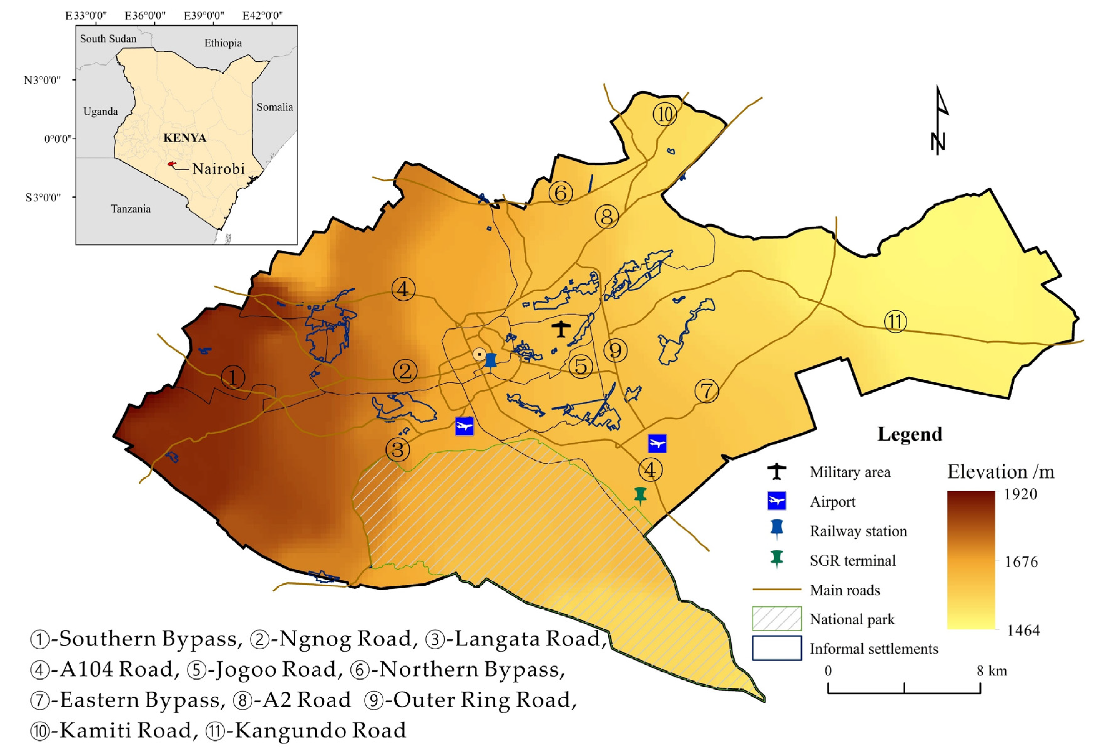
2.1. Data Sources

Collection and analysis of data related to administrative boundaries, population census, and informal settlements are the key points in this study to demonstrate the spatial distribution of informal settlements and their density and structure in Nairobi. The vector data of Kenya’s administrative boundaries are derived from GADM (Database of Global Administrative Areas) (https://www.gadm.org/). GADM provides maps and spatial data for all countries and their subdivisions. The study area we used in this paper was the administrative boundary of Nairobi city. The total administrative region is 684 square kilometers, and the topography inclines from west to east, with the elevation from 1920 to 1464 m (Figure 1).
WorldPop (https://www.worldpop.org/) is an open-access website with high-resolution spatial demographic data for less developed countries and regions. The database uses the method of random forest-based dasymetric redistribution to map the population distribution in Kenya. Their data sources include multiple remote sensing data, administrative data, and national survey data [37]. Their data products have been widely used in demographic research [38,39]. We use 85,798 grids of residential data in Nairobi city for 2000, 2010, and 2020 (estimate data) from WorldPop, with a grid resolution of 100 × 100 m; the units are the number of people per pixel. Administrative subunit data and residential boundaries are important for the analysis of the spatial distribution of informal settlements in Nairobi.
Based on the availability of research data and the UN Habitats classification of “slums” [40], the informal settlements in Nairobi are defined and characterized by nondurable housing, crowded space, and poor living conditions. It is easy to find the main slums or informal settlements in Nairobi using remote sensing images. The informal settlements’ boundaries in Nairobi were extracted by using visual interpretation based on Landsat images (Landsat8-OLI). We also used high-resolution Google maps and Google Street View for correction (Figure 2). The above interpretation and correction work was finished in the platform of Arcgis (10.4.1, ESRI, RedLands, CA, USA). Finally, we extracted 45 informal settlements, each with an acreage of more than 2 hectares. Among them, there are 14 main informal settlements, each with an acreage of more than 40 hectares.

2.2. Moran Indexes and Spatial Agglomeration

A quantitative study of the spatial population agglomeration displays the detailed messages of population distribution and informal settlement agglomeration in Nairobi. In this study, we used the local Moran index to analyze the spatial autocorrelation of population density in Nairobi. Local Moran indexes are widely used in determining the spatial correlation for population and economic factors in urban areas [41,42,43]. We used this method to identify where the spatial agglomeration of population density in the study area is. The formula is constructed as follows:
I i = ( X i X ¯ ) i = 1 n j = 1 n w i j ( X j X ¯ ) S 2 ,   i j
where I i is the local Moran index of grid i;   S 2 is the variance of X ; n is the total number of spatial units;   X i and X j are the population density values between units i and j; X ¯ is the average value of X i and X j ; w i j is a spatial weight matrix.
A high positive I i value implies that grid i has similar high or low values as its neighbors; the location is spatial agglomeration. A high negative I i value implies that grid i is a spatial outlier; its value is obviously different from that of their surrounding grids. As a result, the cluster map of the local Moran index (I) contains five cluster types: high–high (HH), low–low (LL), high–low (HL), low–high (LH), and nonsignificant units. HH and LL indicate positive local spatial correlation and that grid i has a high (or low) population density; it also indicates that the surrounding population density is high (or low). HL and LH indicate negative local spatial correlation and that the population density of grid i is much higher (or lower) than the surroundings. The nonsignificant unit indicates that the correlation between close units is not significant [44]. The HH relationship has significance for identifying the areas of population concentration.

2.3. Population Density Models for Single City Center

Urban economists agree that population density and distance from urban centers are traditionally negatively related. There are many population density models of big cities [27,45]. Previous studies of population density models have used large cities in developed countries, but few quantitative studies have used large cities in less developed regions [24,25,26,45,46]. Population density functions can clearly identify the population changes in different urban circle layers, and this has significance for modeling the urban population distribution in a quantitative way.
In this study, we will examine which functions can best simulate the population distribution in Nairobi. As the Nairobi central business district (CBD) is the core area of the city, we chose classical single-center models to fit the distribution of the urban population. We applied centrographic analysis to locate the central point of Nairobi, which is the mean center estimated from all the population-weighted grids in the CBD area. The population density grid data was clipped by concentric circles, with the city center point as the circle’s center and 500 m as the radius. We calculated the average population density of each sample area. Then, we put the data into the population density models for further analysis. The models we used are as follows:
The Clark model:
y = a e b x
This model was created by Clark in 1951; it is the first exponential function to explain the relationship between urban population density and distance, where y is the population density of a point; x is the linear distance of the point to the city center; a and b are constants, where a represents the population density of the city center [24].
The Newling model:
y = a e b x + c x 2
This model was created by Newling in 1969; it is a variation of the Gaussian function, where c is a constant. The Newling model reveals similar population density change trends as the Clark model. When c = 0, the Newling model is transformed into the Clark model [25].
The McMillen model:
y = a e b x + c 1 x
This model was used by McMillen and McDonald in 1998; it is an improved exponential model based on McMillen’s study on Chicago [26]. When c = 0, the McMillen model is also transformed into the Clark model.
The previous functions are all based on the study of metropolitan areas in developed countries. In order to make our result more credible, we also selected another four models of linear function, quadratic function, cubic function, and logarithmic function for a comparative study:
Linear function:
y = a x + b
Quadratic function:
y = a x 2 + b x + c
Cubic function:
y = a x 3 + b x 2 + c x + d
Logarithmic function:
y = a l n x + b
We will use the population data and compare the results of the above models for the purpose of determining the most suitable population density model for Nairobi.

3. Results

3.1. Identify Where the Population Agglomeration is in Nairobi

Spatial autocorrelation analysis was performed based on the distribution of population density of 2000, 2010, and 2020 to identify the population agglomeration in Nairobi. Geoda software (1.14, University of Chicago, Chicago, IL, USA) was used to calculate the local Moran index for the three periods. The result shown in Figure 3 classifies the areas with high population density in red and low population density in blue; it turns out that Nairobi’s CBD belongs to the LL type, with clusters of low-density population. The areas of HH type are observed on the eastern and southern sides of the urban core area. According to Figure 1 and Figure 3, we find that the informal settlements are the main areas where high population density grids are gathered.

3.2. Changes of Population Density in Informal Settlements

In order to further analyze the population density changes in different areas, we used ArcGIS 10.4 software to calculate the net increased population in Nairobi by subtracting the population grid values of 2000 from that of 2020. Figure 4 shows a quite-small increase in population density nearby Nairobi CBD from 2000 to 2020. However, large-scale informal settlements are distributed around the CBD, such as the Kibera and Mathare slums. The areas outside the urban core area, mostly informal settlements, are witnessing significant population growth. The informal settlements are hot spots for population increase in Nairobi.
We extracted and calculated the population density changes of the informal settlements with larger acreage in Nairobi (Table 1). The result shows that Huruma, Mathare, and Kibera are the most populous informal settlements and also the fastest growing. From 2000 to 2020, the population density of Huruma, Mathare, and Kibera increased by 766.98, 546.27, and 475.27 inhabitants per hectare, respectively. Both Table 1 and Figure 4 indicate that the informal settlements close to the urban core are the areas with the fastest population density increase in Nairobi.

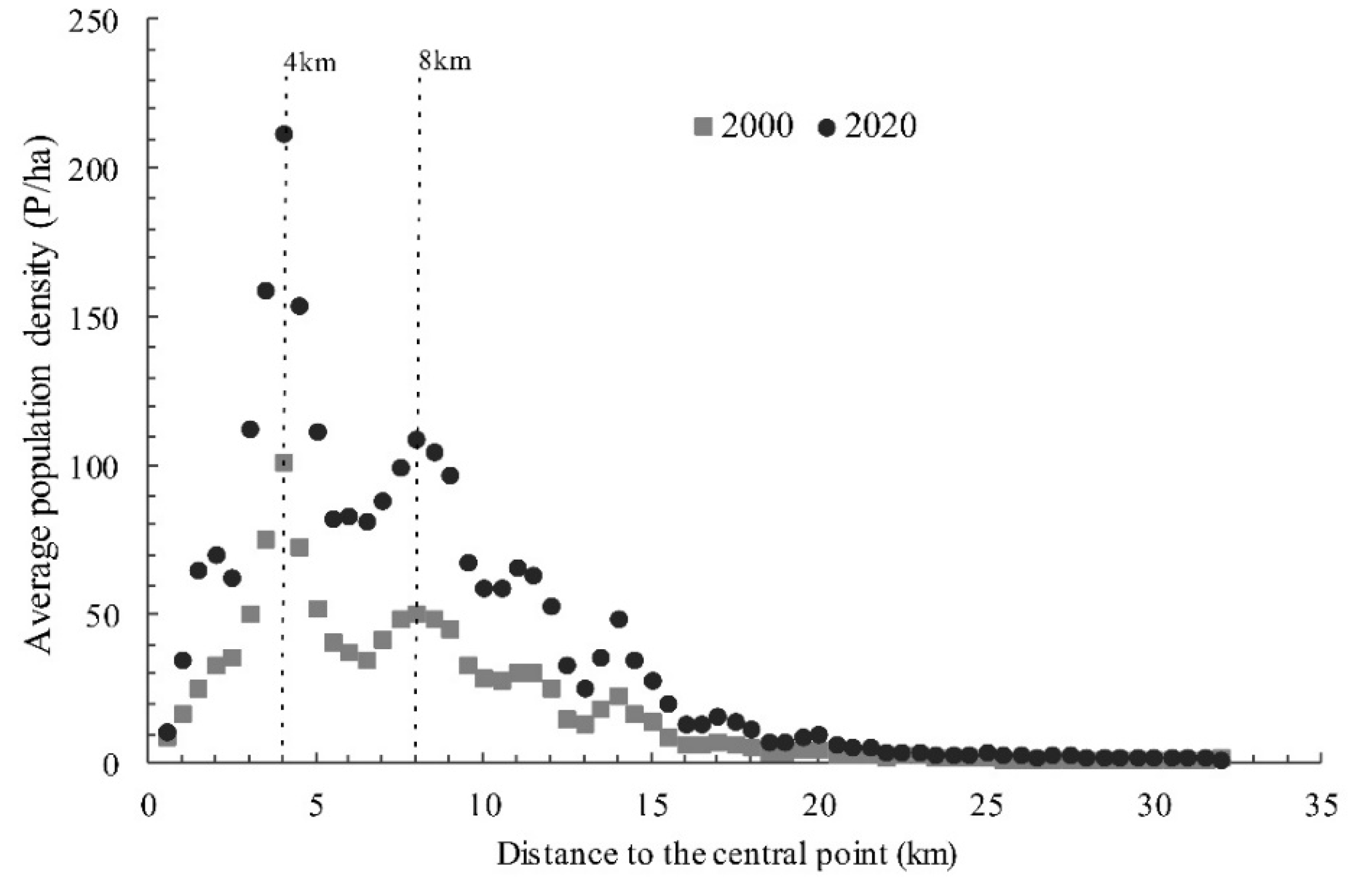
3.3. Determining the Population Density Model for Nairobi

We performed the processing of the population density grid data of Nairobi for 2000 and 2020. The results contain 64 circinate areas of the city, as shown in Figure 5. In addition, we calculated the average population density value of each area.
The correspondence between average population density and the linear distance to the central point is demonstrated in a scatter plot (Figure 6). It is observable that the trends of the two periods are similar for the past 20 years. The maximum population density appears within the area of 4 km from the central point. The correlation between population density and distance seems positive within a 4 km area, while in areas outside 8 km, they are negatively related. Therefore, we used the piecewise function to fit the regions inside and outside the 8 km circle.
The processed population density data and distance data were fitted according to Functions (2)–(8). The results showed that the fitting degree of the Newling and McMillen models is quite good. The fitting degree of the region with x > 8 km is significantly better than that of the region with x ≤ 8 km. As fitting coefficient b of the McMillen model for the region, with x ≤ 8 km, failed to pass the significance test, the fitting was performed again after the model was modified. The results are shown in Table 2.
When x > 8 km, the fitting degree of the Newling model is the best; the R2 value for 2000 and 2020 is 0.947 and 0.978, respectively. When x ≤ 8 km, the McMillen model has the best fitting degree; the R2 value for 2000 and 2020 is 0.729 and 0.821, respectively. Therefore, the following piecewise functions can be used to explain the population density distribution in Nairobi:
2000 :   { y = 60.886 e 1.037 x 1   ( x 8 ,   R 2 = 0.729 ) y = 1754.607 e 0.448 x + 0.007 x 2     ( x > 8 ,   R 2 = 0.947 )
2020 :   { y = 138.518 e 1.260 x 1                 ( x 8 ,   R 2 = 0.821 ) y = 2149.520 e 0.381 x + 0.005 x 2   ( x > 8 ,   R 2 = 0.978 )
The Clark model, the Newling model, and the McMillen model are all based on the research of megacities in developed countries. All their results show that urban population density decreases continuously with distance increases. However, our study found that due to the influence of informal settlement distribution, the population density did not decrease continuously with the increase of distance. The increase of coefficient a indicates that the attractiveness of the population around the 8-km belt is enhanced.
We calculated the minimum value of Formulas (9) and (10). The result shows that when x = 32 and 38.1 (km), Formulas (9) and (10) obtain the minimum value, respectively. The x value corresponding to minimum population density can be regarded as the theoretical boundary of population expansion in Nairobi (32 km in 2000, 38.1 km in 2020). It shows that over the past 20 years, the theoretical boundary has extended 5.9 km outward, which proves that Nairobi has a huge trend of outward expansion.
We also compared the relationship between the population density of informal settlements and the distance to the CBD for 2000 and 2020. As shown in Figure 7, the population density in informal settlements showed a significant increase within a 4-km area and a significant decline outside the 4-km area. The coefficient of x also indicated that the population attractiveness of informal settlements nearby the 4-km belt is quite strong and also increasing rapidly. Due to space constraints in the core urban area, informal settlements nearby the 4-km belt will face greater population pressure in the future, which is also a big challenge to the improvement of the living conditions in informal settlements.

4. Discussions

4.1. More Contribution of Informal Settlements to Population Increase in Nairobi

Informal settlements are hotspots of population increase and gathering in Nairobi. The results show that Nairobi’s population density distribution has a strong positive spatial correlation. Especially in areas with high density, the population’s spatial agglomeration has continued to strengthen over the past 20 years. We also calculated the changes in population density in informal settlements from 2000 to 2020, which had an overall increase of 1.25 times in Nairobi. Meanwhile (from 1999 to 2019), according to census data, the population density of Nairobi increased by just 1.05 times. The growth rate of population density among informal settlements is also different. The informal settlements nearby the 4-km belt, such as Kibera, Mathare, and Huruma, usually have higher population density growth rates, while the informal settlements nearby the 8-km belt usually have a smaller population density.
In addition, according to our results, the size of the population living in informal settlements in Nairobi may have been overestimated by previous studies. For example, we calculated that the population of Kibera was roughly 283,024 in 2020, while the media and politicians usually quote the stunning figure of 700,000 to 1 million inhabitants, which is greatly overestimated. According to Desgroppes and Taupin’s field survey, the population of Kibera was estimated at 204,473, which is very close to our result for 2010 (roughly 198,917 inhabitants) [47]. The population size of the 45 informal settlements we extracted has also been counted, which was roughly 1.1 million in total. It means that about a quarter of Nairobi’s population live in settlements with nondurable housing, crowded spaces, and poor living conditions.

4.2. Factors Determining Population Density Distribution

The expansion of most informal settlements is related to employment opportunities, considering that these areas are mostly established by workers employed in nearby factories and shops or by wealthy families [48,49]. Even though the informal settlements have poor living conditions and a lack of services, they still offer opportunities for housing and work that are not available in the formal sector for vast numbers of people [49,50,51]. Where people choose to settle is a decision process between the expected benefits and the cost of living. The informal settlements have lower living costs and shorter commuting distances and are easier for new immigrants to settle in, all of which drive the rapid population increase and gathering. The spatial layout of informal settlements is also affected by the apartheid in history. There is obvious residential segregation between the formal and informal settlements areas in Nairobi [33]. This pattern has been stable for a long time. The research by K’akumu and Olima proves that almost all high-end and middle-class houses share borders with, but, at the same time, draw barriers against informal settlements [21].
The population distribution model proves that there is a significant correlation between population density and the distance to the city center. The urban core usually has better job opportunities; however, this comes with higher rents. People have to find a balance between commuting distance and the cost of living, and the 4-km belt has become the best choice for the people working in the urban core. Thus, within 4 km, population density is positively correlated with distance. The 8-km belt nearby the urban fringe area is undergoing dramatic urban expansion, and it is also the major area for the layout of industries. More people are willing to settle in the 8-km belt because of the lower living cost and the distance to their workplaces. Outside the 8-km belt, the population density drops rapidly with an increase of distance.

4.3. Suggestions to Policymakers in Urban Management

The governance and urban management of informal settlements in Kenya are complex and have systematic issues. A series of upgrading programs has been implemented. However, due to the lack of accurate understanding of the characteristics of informal population distribution, many efforts have not achieved the expected results [52,53]. Our study concludes that the settlements nearby the 4-km and 8-km belts are more attractive to new urban immigrants. More people are willing to settle in the areas close to the urban core, which will put tremendous pressure on the population density and living conditions of informal settlements in this area.
For policymakers, the first thing to do is to guide the rational distribution of new migrants through the tools of housing policies and land rents. The housing rents and urban service costs in the urban fringe can be lowered to attract new immigrants and relieve the population pressure on the urban core. Then, by improving the urban environment, optimizing the industrial layout, and enhancing urban services, the distant informal settlements could be transformed into a fully functional residential area or other types of formal-function area. By upgrading the housing and by building upwards, the land-use efficiency and living conditions of the central informal settlements could also be improved. With the support of housing and land policies, the population of informal settlements can also gradually migrate to new formal settlements and satellite cities. In addition, the global urban growth experiences indicate that a single city center is more likely to cause overcrowding in built-up areas and reduce urban efficiency [54,55]. In order to alleviate the population pressure in the urban core and optimize the urban functional zone in Nairobi, we suggest that a subcity center should be of concern in the future.

4.4. Limitations and Further Research

This article shows the application of multisource geographic information data in the study of population spatial structures; however, the limitations still exist in this work. The main informal settlement boundaries were extracted from the information reflected by satellite imagery, and it cannot completely reflect the distribution characteristics of all informal settlements in Nairobi. Moreover, there are deviations between the visual interpretation and actual situations, but they are within the acceptable range of our study. In addition, a number of factors influence population density in Nairobi, including urban road networks, topographic features, waterways, housing policies, and historical causes. Our model analysis provides a geographical explanation of the spatial distribution of the population in the study area instead of a detailed analysis of the influence factors. The factors related to the population distribution will be investigated in future studies.
Our research shows that remote sensing and GIS technology play a remarkable role in urban population research. For further research, more reasonable and accurate methods based on remote sensing and GIS should be developed to study the distribution of human settlements in Nairobi. More comprehensive methods and survey data should be used to discuss the influencing mechanism in the population process.

5. Conclusions

This study has shed light on the patterns and spatial structure of the population in Nairobi based on population density raster data with a resolution of 100 m. Changes in informal settlements are at the core of our concern. The main conclusions are as follows:
(1)
In the past 20 years, the population density of Nairobi has increased rapidly, and informal settlements are the centers of population growth and agglomeration.
(2)
Due to the influence of the large-scale distribution of informal settlements, the classic population density models cannot explain the population distribution pattern of cities in Kenya well. Our finding is that piecewise exponential functions are more suitable.
(3)
The informal settlements are usually close to areas where urbanization is booming. The 4-km and 8-km belts are the main areas that the population is gathering. Employment, housing, and commuting are the main factors affecting the development of informal settlements.
(4)
The correlation between population density and distance is positive within the 4-km area, while in areas outside 8 km, they are negatively related. We also concluded that the informal settlements nearby the 4-km belt will face greater population pressure in the future.
Although the Nairobi government has carried out some projects to upgrade informal settlements during the past decade, the informal settlements are still under pressure from the urban core of Nairobi. Further policies and subcity center planning should be implemented for better urban management of the mega-Nairobi city in the future.

Author Contributions

Conceptualization, H.R., W.G., and Z.Z.; methodology, H.R.; software, H.R. and P.D.; validation, Z.Z. and W.G.; formal analysis, P.D.; investigation, L.M.K.; data curation, X.X.; writing—original draft preparation, H.R.; writing—review and editing, W.G., L.M.K., and Z.Z.; visualization, H.R.; supervision, Z.Z.; funding acquisition, Z.Z. All authors have read and agreed to the published version of the manuscript.

Funding

This research was funded by “Fundamental Research Funds for the Central Universities” (No. 14370401) and the project commissioned by the International Scientific and Technological Innovation Cooperation Key Project of the National Key R&D Program (No. 2018YFE0105900).

Conflicts of Interest

The authors declare no conflict of interest.

References

  1. Alder, G. Tackling poverty in Nairobi’s informal settlements: Developing an institutional strategy. Environ. Urban. 1995, 7, 85–108. [Google Scholar] [CrossRef]
  2. Simiyu, S.; Cairncross, S.; Swilling, M. Understanding living conditions and deprivation in informal settlements of Kisumu, Kenya. Urban Forum 2019, 30, 223–241. [Google Scholar] [CrossRef] [Green Version]
  3. United Nations Human Settlements Programme (UN-Habitat). Habitat III Issue Paper 22—Informal Settlements; Report of the Conference on Housing and Sustainable Urban Development; United Nations Human Settlements Programme: New York, NY, USA, 2016. [Google Scholar]
  4. Satterthwaite, D.; Sverdlik, A.; Brown, D. Revealing and responding to multiple health risks in informal settlements in sub-Saharan African cities. J. Urban Health 2019, 96, 112–122. [Google Scholar] [CrossRef] [PubMed]
  5. United Nations Human Settlements Programme (UN-Habitat). UN-Habitat Support to Sustainable Urban Development in Kenya: Addressing Urban Informality. 2016. Available online: https://unhabitat.org/sites/default/files/download-manager-files/UN-Habitat%20SSUDK_%20Report_Vol%204_final.LowRes.pdf (accessed on 21 June 2020).
  6. Kamunyori, S.W. Concept Project Information Document Integrated Safeguards Data Sheet. Report of Kenya Informal Settlements Improvement Project 2-P167814, World Bank Group, 2019. Available online: https://documents.worldbank.org/en/publication/documents-reports/documentdetail/500301511794282642/concept-project-information-document-integrated-safeguards-data-sheet (accessed on 16 June 2020).
  7. Keivani, R. A review of the main challenges to urban sustainability. Int. J. Urban Sustain. Dev. 2010, 1, 5–16. [Google Scholar] [CrossRef]
  8. Penrose, K.; De Castro, M.C.; Werema, J.; Ryan, E.T. Informal urban settlements and cholera risk in Dar es Salaam, Tanzania. PLoS Negl. Trop. Dis. 2010, 4, e631. [Google Scholar] [CrossRef] [PubMed]
  9. Sverdlik, A. Ill-health and poverty: A literature review on health in informal settlements. Environ. Urban. 2011, 23, 123–155. [Google Scholar] [CrossRef]
  10. Obudho, R.A. Nairobi: National capital and regional hub. In The Urban Challenge in Africa: Growth and Management of Its Large Cities; Rakodi, C., Ed.; United Nations University Press: Tokyo, Japan; New York, NY, USA; Paris, France, 1997; pp. 292–336. [Google Scholar]
  11. Kenya National Bureau of Statistics (KNBS). 2019 Kenya Population and Housing Census Volume I: Population by County and Sub-County; KNBS Publications: Nairobi, Kenya, 2019. [Google Scholar]
  12. Amnesty International. Kenya: The Unseen Majority: Nairobi’s Two Million Slum-Dwellers; Amnesty International Publications: London, UK, 2019; p. 3. [Google Scholar]
  13. African Population and Health Research Center (APHRC). Population and Health Dynamics in Nairobi’s Informal Settlements. Report of the Nairobi Cross-sectional Slums Survey (NCSS), 2012. Available online: https://assets.publishing.service.gov.uk/media/57a089f240f0b64974000338/NCSS2-FINAL-Report.pdf (accessed on 7 June 2020).
  14. De Filippi, F.; Cocina, G.G.; Martinuzzi, C. Integrating different data sources to address urban security in informal areas. The case study of Kibera, Nairobi. Sustainability 2020, 12, 2437. [Google Scholar] [CrossRef] [Green Version]
  15. Wilkinson, A. Local response in health emergencies: Key considerations for addressing the COVID-19 pandemic in informal urban settlements. Environ. Urban. 2020, 1–20. [Google Scholar] [CrossRef]
  16. Mutisya, E.; Yarime, M. Understanding the grassroots dynamics of slums in Nairobi: The dilemma of Kibera informal settlements. Int. Trans. J. Eng. Manag. Appl. Sci. Technol. 2011, 2, 197–213. [Google Scholar]
  17. Mundia, C.N.; Aniya, M. Analysis of land use/cover changes and urban expansion of Nairobi city using remote sensing and GIS. Int. J. Remote Sens. 2005, 26, 2831–2849. [Google Scholar] [CrossRef]
  18. Champion, A.G. A changing demographic regime and evolving poly centric urban regions: Consequences for the size, composition and distribution of city populations. Urban Stud. 2001, 38, 657–677. [Google Scholar] [CrossRef]
  19. Kabisch, N.; Haase, D. Diversifying European agglomerations: Evidence of urban population trends for the 21st century. Popul. Space Place 2011, 17, 236–253. [Google Scholar] [CrossRef]
  20. Wanyama, R.; Gödecke, T.; Qaim, M. Food security and dietary quality in African slums. Sustainability 2019, 11, 5999. [Google Scholar] [CrossRef] [Green Version]
  21. K’akumu, O.A.; Olima, W.H.A. The dynamics and implications of residential segregation in Nairobi. Habitat Int. 2007, 31, 87–99. [Google Scholar] [CrossRef]
  22. Beguy, D.; Bocquier, P.; Zulu, E.M. Circular migration patterns and determinants in Nairobi slum settlements. Demogr. Res. 2010, 23, 549–586. [Google Scholar] [CrossRef]
  23. Cosentino, C.; Amato, F.; Murgante, B. Population-based simulation of urban growth: The Italian case study. Sustainability 2018, 10, 4838. [Google Scholar] [CrossRef] [Green Version]
  24. Clark, C. Urban population densities. J. R. Stat. Soc. Ser. A 1951, 114, 490–496. [Google Scholar] [CrossRef]
  25. Newling, B.E. The spatial variation of urban population densities. Geogr. Rev. 1969, 59, 242–252. [Google Scholar] [CrossRef]
  26. McMillen, D.P.; McDonald, J.F. Suburban subcenters and employment density in metropolitan Chicago. J. Urban Econ. 1998, 43, 157–180. [Google Scholar] [CrossRef] [Green Version]
  27. Xu, G.; Jiao, L.; Yuan, M.; Dong, T.; Zhang, B.; Du, C. How does urban population density decline over time? An exponential model for Chinese cities with international comparisons. Landsc. Urban Plan. 2019, 183, 59–67. [Google Scholar] [CrossRef]
  28. Mundia, C.N.; Aniya, M. Dynamics of landuse/cover changes and degradation of Nairobi City, Kenya. Land Degrad. Dev. 2006, 17, 97–108. [Google Scholar] [CrossRef]
  29. Mberu, B.U.; Ezeh, A.C.; Chepngeno-Langat, G.; Kimani, J.; Oti, S.; Beguy, A.D. Family ties and urban–rural linkages among older migrants in nairobi informal settlements. Popul. Space Place 2013, 19, 275–293. [Google Scholar] [CrossRef]
  30. Githira, D.N. Growth and Eviction of Informal Settlements in Nairobi; University of Twente Faculty of Geo-Information and Earth Observation (ITC): Enschede, The Netherlands, 2016; p. 103. [Google Scholar]
  31. Corburn, J.; Karanja, I. Informal settlements and a relational view of health in Nairobi, Kenya: Sanitation, gender and dignity. Health Promot. Int. 2014, 31, 258–269. [Google Scholar] [CrossRef] [PubMed] [Green Version]
  32. Taffa, N.; Chepngeno, G. Determinants of health care seeking for childhood illnesses in Nairobi slums. Trop. Med. Int. Health 2005, 10, 240–245. [Google Scholar] [CrossRef] [PubMed]
  33. Olima, W.H. The Dynamics and Implications of Sustaining Urban Spatial Segregation in Kenya: Experiences from Nairobi Metropolis; Lincoln Institute of Land Policy: Cambridge, MA, USA, 2017. [Google Scholar]
  34. Zulu, E.M.; Beguy, D.; Ezeh, A.C.; Bocquier, P.; Madise, N.J.; Cleland, J.; Falkingham, J. Overview of migration, poverty and health dynamics in Nairobi City’s slum settlements. J. Urban Health 2011, 88, 185–199. [Google Scholar] [CrossRef] [Green Version]
  35. Kahimbaara, J.A. The population density gradient and the spatial structure of a third world city: Nairobi, a case study. Urban Stud. 1986, 23, 307–322. [Google Scholar] [CrossRef]
  36. Visagie, J.; Turok, I. Getting urban density to work in informal settlements in Africa. Environ. Urban. 2020, 1–20. [Google Scholar] [CrossRef]
  37. Lloyd, C.T.; Sorichetta, A.; Tatem, A.J. High resolution global gridded data for use in population studies. Sci. Data 2017, 4, 1–17. [Google Scholar] [CrossRef] [Green Version]
  38. Linard, C.; Gilbert, M.; Snow, R.W.; Noor, A.M.; Tatem, A.J. Population distribution, settlement patterns and accessibility across Africa in 2010. PLoS ONE 2012, 7, e31743. [Google Scholar] [CrossRef] [Green Version]
  39. Tatem, A.J. Worldpop, open data for spatial demography. Sci. Data 2017, 4, 1–4. [Google Scholar] [CrossRef]
  40. United Nations Human Settlements Programme (UN-Habitat). The State of the World’s Cities Report 2006/2007: 30 Years of Shaping the Habitat Agenda; Earthscan: London, UK, 2017; p. 185. [Google Scholar]
  41. Areum, J.; Lee, S.K.; Kim, J. Gender gaps in the use of urban space in Seoul: Analyzing spatial patterns of temporary populations using mobile phone data. Sustainability 2020, 12, 6481. [Google Scholar]
  42. Ma, G.; Hofmann, E.T. Population, immigration, and air quality in the USA: A spatial panel study. Popul. Environ. 2019, 40, 283–302. [Google Scholar] [CrossRef]
  43. Yu, D.; Zhang, Y.; Wu, X. How socioeconomic and environmental factors impact the migration destination choices of different population groups in China: An eigenfunction-based spatial filtering analysis. Popul. Environ. 2020, 41, 372–395. [Google Scholar] [CrossRef]
  44. He, Y.; Zhou, G.; Tang, C.; Fan, S.; Guo, X. The spatial organization pattern of urban-rural integration in urban agglomerations in China: An agglomeration-diffusion analysis of the population and firms. Habitat Int. 2019, 87, 54–65. [Google Scholar] [CrossRef]
  45. Chen, Y. A new model of urban population density indicating latent fractal structure. Int. J. Urban Sustain. Dev. 2010, 1, 89–110. [Google Scholar] [CrossRef] [Green Version]
  46. Qiang, Y.; Xu, J.; Zhang, G. The shapes of US cities: Revisiting the classic population density functions using crowdsourced geospatial data. Urban Stud. 2019, 57, 2147–2162. [Google Scholar] [CrossRef]
  47. Desgroppes, A.; Taupin, S. Kibera: The biggest slum in Africa? Les Cahiers d’Afrique de l’Est/The East African Review. Available online: http://journals.openedition.org/eastafrica/521 (accessed on 15 June 2020).
  48. Aina, T.A. Petty landlords and poor tenants in a low-income settlement in metropolitan Lagos, Nigeria. In Housing Africa’s Urban Poor; Amis, B.P., Lloyd, P., Eds.; Routledge: London, UK, 2018; pp. 87–101. [Google Scholar]
  49. Marx, B.; Stoker, T.; Suri, T. The economics of slums in the developing world. J. Econ. Perspect. 2013, 27, 187–210. [Google Scholar] [CrossRef] [Green Version]
  50. Li, B.; Chen, C.; Hu, B. Governing urbanization and the new urbanization plan in China. Environ. Urban. 2016, 28, 515–534. [Google Scholar] [CrossRef]
  51. Bird, J.; Montebruno, P.; Regan, T. Life in a slum: Understanding living conditions in Nairobi’s slums across time and space. Oxf. Rev. Econ. Policy 2017, 33, 496–520. [Google Scholar] [CrossRef]
  52. Ono, H.; Kidokoro, T. Understanding the development patterns of informal settlements in Nairobi. Jap. Archit. Rev. 2020, 3, 384–393. [Google Scholar] [CrossRef]
  53. Mcgill, R. Urban management in developing countries. Cities 1998, 15, 463–471. [Google Scholar] [CrossRef]
  54. Arribas-Bel, D.; Sanz-Gracia, F. The validity of the monocentric city model in a polycentric age: US metropolitan areas in 1990, 2000 and 2010. Urban Geogr. 2014, 35, 980–997. [Google Scholar] [CrossRef] [Green Version]
  55. Ahlfeldt, G.M.; Wendland, N. How polycentric is a monocentric city? Centers, spillovers and hysteresis. J. Econ. Geogr. 2013, 13, 53–83. [Google Scholar] [CrossRef] [Green Version]
Figure 1. Location and topographic map of Nairobi, Kenya.
Sustainability 12 07717 g001
Figure 2. Boundaries and photos of informal settlements in Nairobi, taking Kibera, Estate, and Viwandani as examples.
Sustainability 12 07717 g002
Figure 3. Local Moran’s I cluster map of Nairobi’s population density (excluding the national park) in 2000, 2010, and 2020.
Sustainability 12 07717 g003
Figure 4. Distribution of net increased population density in Nairobi from 2000 to 2020.
Sustainability 12 07717 g004
Figure 5. The population density grid of Nairobi (excluding the national park) for 2020, clipping by the concentric circles.
Sustainability 12 07717 g005
Figure 6. Relationship between population density and distance to Nairobi’s city center.
Sustainability 12 07717 g006
Figure 7. Relationship between population density of informal settlements and distance, Nairobi.
Sustainability 12 07717 g007
Table 1. Population density changes of Nairobi’s main informal settlements in 2000, 2010, and 2020.
NumberNameArea/haInhabitants/haNet Increased Inhabitant/ha
2000–2020
200020102020
1Dandora182.15248.61403.18585.31336.7
2Huruma78.14614.44911.931381.42766.98
3Estate249.08146.32281.17318.26171.94
4Kangwangware329.14186.25272.76399.94213.69
5Kiambiu50.02284.26529.78714.16429.9
6Kibera287.13439.43671.88985.70546.27
7Korogocho99.74281.84481.86588.93307.09
8Kwa Njenga133.21155.26257.00358.74203.48
9Majengo60.45253.27380.81577.98324.71
10Mathare100.70329.72519.27804.99475.27
11Mukuru49.0292.56122.61186.9594.39
12Sweto192.23139.83224.86333.45193.62
13Tsaaia40.51125.09188.38257.73132.64
14Viwandani167.11140.22211.09306.58166.36
Table 2. Fitting results of the spatial distribution of population density.
ModelsYearAreaabcdR2
Linear 2000x ≤ 8 km3.254 31.365 * 0.114
x > 8 km−1.457 ** 39.043 ** 0.681
2020x ≤ 8 km7.249 65.098 * 0.125
x > 8 km−3.114 ** 83.102 ** 0.681
Quadratic2000x ≤ 8 km−2.890 * 27.816 * −5.477 0.491
x > 8 km0.142 ** −7.224 ** 90.599 ** 0.930
2020x ≤ 8 km−6.170 * 59.692 * −13.567 0.504
x > 8 km0.300 ** −15.251 ** 191.614 ** 0.923
Cubic 2000x ≤ 8 km0.711 −11.957 59.588 * −31.319 0.582
x > 8km−0.008 * 0.623 ** −16.272 ** 142.459 ** 0.908
2020x ≤ 8 km1.530 −25.677 128.044 * −69.162 0.597
x > 8 km−0.018 ** 1.395 ** −35.870 ** 309.784 ** 0.955
Ln2000x ≤ 8 km15.188 * 26.609 0.273
x > 8 km−29.356 ** 95.904 ** 0.814
2020x ≤ 8 km33.529 * 54.870 * 0.293
x > 8 km−62.667 ** 204.423 * 0.813
Clark model2000x ≤ 8 km22.514 * 0.131 * 0.276
x > 8 km159.973 ** −0.180 ** 0.900
2020x ≤ 8 km42.445 * 0.153 ** 0.283
x > 8 km382.604 ** −0.188 ** 0.954
Newling model2000x ≤ 8 km8.061 * 0.816 ** −0.081 ** 0.714
x > 8 km1754.607 ** −0.448 ** 0.007 ** 0.947
2020x ≤ 8 km13.290 ** 0.927 ** −0.091 ** 0.705
x > 8 km2149.520 ** −0.381 ** 0.005 ** 0.978
McMillen model2000x ≤ 8 km60.886 ** −1.037 ** 0.729
x > 8 km5.918 ** −0.094 **27.432 ** 0.927
2020x ≤ 8 km138.518 ** −1.260 ** 0.821
x > 8 km28.847 ** −0.121 **21.508 ** 0.970
Note: All functions have passed the F-test; * ρ < 0.05, ** ρ < 0.01.

