Article

Analysis of Environmental Purification Effect of Riparian Forest with Poplar Trees for Ecological Watershed Management: A Case Study in the Floodplain of the Dam Reservoir in Korea

1
Department of Water Environmental Management, K-Water, Daejeon 34350, Korea
2
Department of Environmental Science & Ecological Engineering, Korea University, Seoul 02841, Korea
3
Department of Forest∙Landscape Architecture & Institute for Environmental Science, Wonkwang University, Iksan 54538, Korea
*
Author to whom correspondence should be addressed.
Sustainability 2020, 12(17), 6871; https://doi.org/10.3390/su12176871
Submission received: 10 July 2020 / Revised: 17 August 2020 / Accepted: 22 August 2020 / Published: 24 August 2020

Abstract

:
The Total Nitrogen(T-N) and Total Phosphors(T-P) contents in the soils of three riparian forests with poplar trees were compared with the surrounding cultivated and uncultivated lands. Three key results were obtained by analyzing poplar tree volume and the T-N and T-P content in the plant body. First, in soil surveys covering 36 points, the T-N and T-P content in the riparian forests were 0.064% and 0.036%, respectively, whereas in non-riparian forests, they were 0.147% and 0.101%, respectively. The two areas had significantly different T-N and T-P values. Within the non-riparian-forest category, the T-N and T-P content in cultivated land was 0.174% and 0.103%, respectively, showing significant differences from riparian forest values. When comparing riparian forests and uncultivated land, the T-N contents were not significantly different (p > 0.113), but the T-P content of 0.095% showed a significant difference (p < 0.006). Second, the total poplar tree volumes of the riparian forest test sites 1, 2, and 3 were 466.46 m3, 171.34 m3, and 75.76 m3, respectively. The T-N and T-P accumulation per unit area was the largest in site 1, at 497.75 kg/ha and 112.73 kg/ha, respectively. The larger the tree volume, the larger the T-N and T-P accumulation in the plant body, and the lower the T-N and T-P content in the soil. Third, analyzing the T-N and T-P removal rate in relation to the environmental conditions of the riparian forests showed that site 3 had the smallest total poplar tree content, and the T-N and T-P accumulation per unit area (ha) was also relatively low at just 56% and 68% of the average value. The main causes of this outcome are thought to be the differences in environmental conditions, such as the crop cultivated before poplar planting began and the terrain. The research results verify that riparian forests with poplar trees reduced T-N and T-P content in the soils. The growth of poplar is expected to increase the removal of T-N and T-P from the soil and contribute to the reduction of various nonpoint source pollution flows into rivers and lakes and to the purification of soil in flooded areas. Therefore, riparian forests can act as a form of green infrastructure and as a system to remove nonpoint source pollution in ecological watershed management.

1. Introduction

Global climate change has increased the frequency or intensity of typhoons, floods, and droughts in recent decades.
These phenomena have a significant effect on rainfall patterns, which in turn cause significant changes in runoff [1]. As runoff makes its way to rivers, lakes, and estuaries after rainfall, high concentrations of nutrients such as nitrogen and phosphorous that have accumulated in surficial sediments or in the groundwater worsen water quality and weaken the health of watershed ecosystems. Cultivated land in watersheds in particular greatly depends on external inputs such as fertilizers and compost because the land lacks the nitrogen required for the production and harvest of crops [2]. Food and energy production from agriculture, combined with industrial and energy sources, have more than doubled the amount of reactive nitrogen circulating annually on land [3]. However, nitrogen and phosphorous originating from over-application of fertilizers and compost are becoming major sources of water pollution in rivers, lakes, and groundwater [4]. A well-managed supply of nutrients does not have a severe impact on the environment, but excess nutrients that have accumulated in the soil or on the surface are swept away together with runoff during rainfall into large bodies of water, thus causing eutrophication. It is generally estimated that 70~80% of the nitrogen present in watersheds is accumulated in plants and the soil or is released to the atmosphere through denitrification, while the remainder flows into rivers [5,6]. Integrated nutrient management (INM), which precisely manages the input and output of nutrients to balance crops while minimizing environmental loads, was introduced in the 1980s, and since then chemical fertilizer use has improved through appropriate fertilization management in cultivated land [7]. Consequently, the excess nutrient problem in Organization for Economic Co-operation and Development (OECD) countries has generally improved; during the period from 1993 to 2015, the average nitrogen balance decreased from 32.4 to 30 kg/ha/yr, and the phosphorous balance from 3.3 to 2 kg/ha/yr. However, among the OECD countries, South Korea is still using large amounts of fertilizers and composts, and the nitrogen and phosphorous released from cultivated lands are still affecting water quality in surrounding water systems [8]. Various green infrastructure techniques are being presented as part of the Best Management Practice to reduce nonpoint source pollution that flows as runoff and base flow from watersheds into rivers and lakes. Among these potential management techniques, riparian forests have been suggested as an eco-friendly and sustainable measure [9,10]. Using green infrastructure systems such as riparian forests and wetlands can complement gray infrastructure and give greater incentives while providing more cost-effective ecosystem services that use natural forces and structures [11]. Riparian forests are highly efficient spaces for water and material circulation, pollutant purification, and flood mitigation. They provide people with numerous benefits such as clean air, moisture, oxygen, space for leisure, and add value to the land. Particularly in urban areas, they are also an important nature-based solution that mitigates the risks of, and adapts to, climate change [12].
The phytoremediation of riparian forests is a decontamination method that removes pollutants from the ecosystem using plants before the pollutants can flow into rivers and lakes via interflow and baseflow. The principle of phytoremediation is to remove or lower the concentration of harmful substances in polluted water and soils, either directly via the metabolic processes of plants, or indirectly via microorganisms in the root systems of plants [13].
In order to remove more pollutants that flow from waterfront areas into water systems, riparian forests need to be composed of tree species that have high adaptability to the environment and excellent growth and biomass production capabilities, such as poplar.
This is because even though the pollutant concentration in plant tissue would be relatively small, the total amount of absorption per organism would increase with an increase in biomass [14,15]. Poplar is a common name called all species belonging to “Genus Populus”. Poplars can be found anywhere in the world except for the tropics, and have shorter generations and easier asexual growth than other species. Therefore, Poplar is widely used as a model breed of traditional breeding or biotechnology in the forest field [16,17]. As an example of a tree with rapid growth, poplar has a strong resistance to pollutants and can adapt to various environments extremely well. Since poplar stems can grow 3~5 m and the roots 3~4 m per year, they can absorb a lot of pollutants across a large area [13,18]. Furthermore, owing to the excellent development of rootlets, poplar trees are good at absorbing moisture and nutrients, and can improve soil quality by providing a good habitat for soil microorganisms [19].
While riparian forests are efficient at removing pollutants that are flowing into rivers, scientific research to verify their decontamination effects has been insufficient [20]. In particular, while many studies have been conducted on water purification efficiency, case studies on soil purification efficiency, which is highly related to base runoff, are more limited. In order to analyze the purification effect of riparian forests, long-term monitoring data before and after planting are required, but because field measurements are often impossible, the effect is predicted through modeling [20]. The physical, chemical, and biological processes and outcome prediction of riparian forests can be modeled using the SWAT-REMM (Soil and Water Assessment Tool-Riparian Ecosystem Management Model) model [21,22,23,24]. This model can be used to simulate and predict the effects of riparian forests. However, the actual effects may vary depending on the environment, tree species, size, and tree growth stage of the area. It is also a study that simulates the effect of improving water quality expected when planting riparian forests throughout a specific watershed, and there is a limitation in considering land use, topography, climate, and pollution source characteristics of a wide range of watersheds. Moreover, there is considerable uncertainty inherent in predicted values, not actual values [24]. Recently, many poplars have been planted near rivers and lakes in South Korea for environmental purification purposes. Yeo et al. conducted a study on the three-year poplars planted along the river in 2010. Rather than the actual purification efficiency of poplar considering environmental conditions such as land use before planting, the research was conducted focusing on the estimation of nitrogen storage capacity according to biomass growth [25]. In order to find the optimal planting and management method for poplar trees, empirical studies on the soil purification effect, tree growth rate, and pollutant absorption ability of the trees are necessary. In this study, the effect of soil purification and the accumulation of nitrogen and phosphorus in trees are measured and analyzed when poplar is planted on farmland where pollutants have been accumulated by crop cultivation in the floodplain within the dam for a long period of time to verify and maximize the effect of the actual composition of riparian forests.
Therefore, to verify the environmental purification effect of riparian forests with poplar trees in cultivated land in waterside regions, this study chose a waterside area of the Yongdam dam reservoir in Jinan-gun, Jeollabuk-do as a case study site, to address the following three questions:
  • First, does a riparian forest have a different rate of removal of nitrogen and phosphorus from the soil when compared to other areas?
  • Second, does poplar tree growth affect the accumulation rate of nitrogen and phosphorous in the trees?
  • Third, are there differences in the growth rate of riparian forests and in the removal of nitrogen and phosphorous from soils depending on the environmental conditions?
The answers to these questions will contribute to the quantitative verification of the function of riparian forests as green infrastructure and the set-up of nonpoint source pollution management measures. Furthermore, the results can potentially be used to inform ecological watershed management.

2. Materials and Methods

2.1. Study Scope and Area

The temporal scope of this study began at the start of poplar planting in 2013, and lasted until the analysis of its effects was carried out in 2020. The spatial scope covered three waterside areas 50,000 m2 in size, located around the Yongdam dam reservoir in Jinan-gun, Jeollabuk-do. The study area is located in the mountainous region of the southern inland area of the Korean Peninsula, with large temperature range and heavy snowfall and rainfall. The annual temperature is −17.7~32.5 °C, the average annual temperature is 11.2 °C, and the average annual precipitation is 1298 mm during the last 5 years In the study site, in the summer from July to August, 50 to 60% of the annual rainfall is rained due to the influence of high temperature and high humidity in the North Pacific Ocean [26]. Mechanisms such as absorption and movement of nutrients in soil and plants can be changed continuously according to characteristics such as precipitation and precipitation period, and the measured values of T-N and T-P can be greatly affected by the time of investigation. Therefore, surveys and analyzes were conducted from autumn to spring when precipitation was relatively small and there was little change. To clearly determine the environmental purification effect of riparian forests, three riparian forests with poplar trees that were planted over 5 years ago and sufficiently grown were selected and analyzed (see Figure 1). The reason we chose the poplar we planted five years ago, this is because poplars are short-lived, and if they are more than three to five years old, they can be harvested and used for wood production and biomass. In Korea, the “Enforcement Decree of the Forest Resources Development and Management Act” stipulates that poplars earn three years. In this regard, poplars that have been over five years have been selected as materials for this study
Test site 1: 63-1, Unbong-ri, Jucheon-myeon, Jinan-gun
Test site 2: 570-44, Wolpyeong-ri, Jeongcheon-myeon, Jinan-gun
Test site 3: 778-1, Galhyeon-ri, Sangjeon-myeon, Jinan-gun

2.2. Planting Poplar for Test

To support the growth of the poplar trees, a 1.5 m-wide drainage channel was installed outside the sites, and the soil was dug more than 0.3 m in depth and turned over to improve the aeration and physicochemical properties of the soil. Next, at each site, year-old seedlings of Populus deltoides and Populus deltoides × P. nigra hybrids were planted together along the waterside at intervals of 2 m × 2 m (Table 1, Figure 2).

2.3. Research Method

(1) Research Framework
This study aimed to investigate the environmental purification effect of planting poplars in cultivated lands located waterside around a dam reservoir.
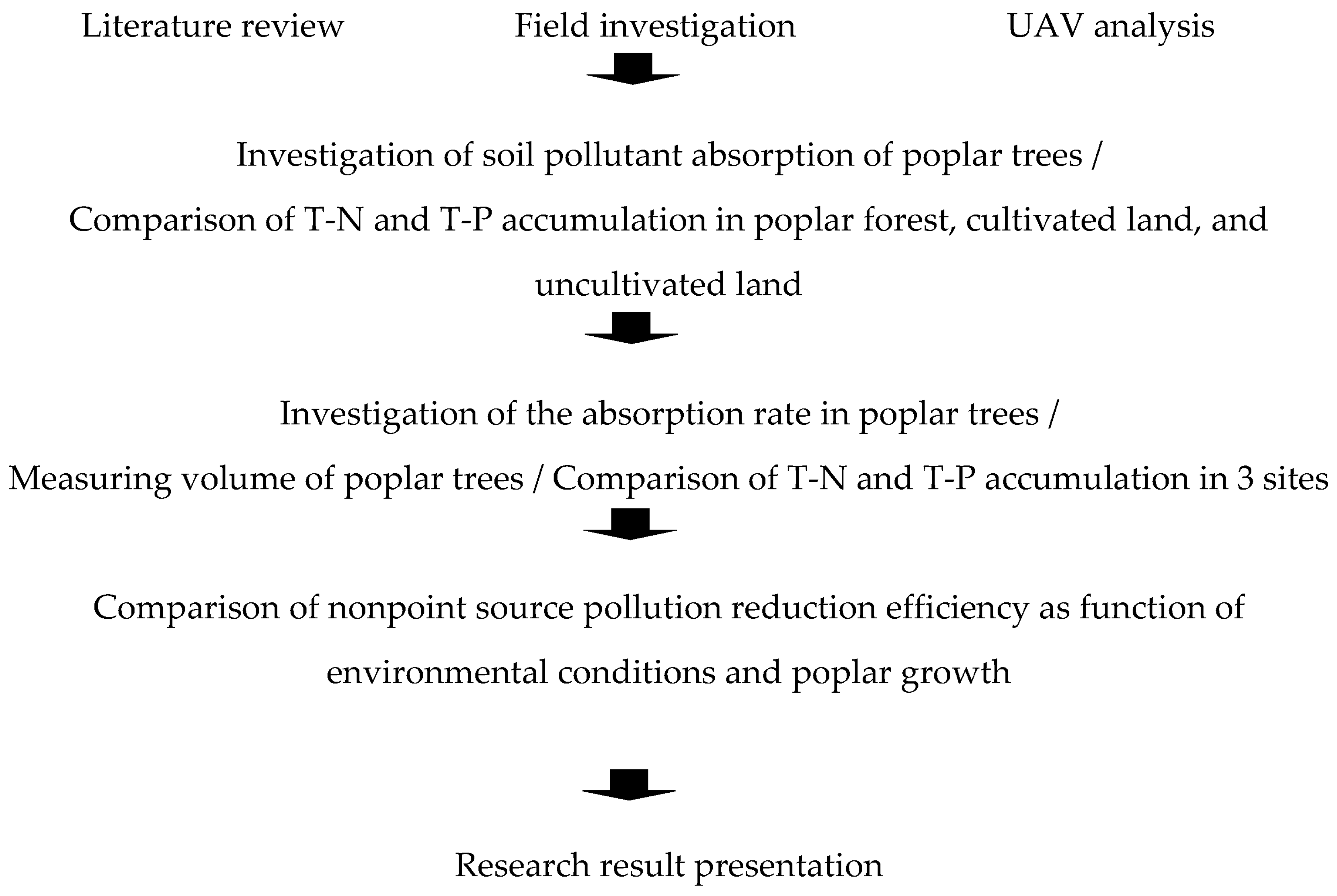
First, the environmental conditions of each site were identified using a review of related literature, field investigations, and unmanned aerial vehicle (UAV) photography. Second, to verify the soil purification effect of poplars, the total T-N and T-P content (T-N and T-P) of the soil in the poplar plantation sites and the uncultivated and cultivated lands around them were measured and compared. Around 50,000 m2 of three test sites planted with poplars, more than 100,000 m2 of cultivated and uncultivated land are distributed. Ginseng, peppers, potatoes, green onions, and sesame are mainly grown in cultivated land. Uncultivated land is a land that has not been cultivated for more than a year. Currently, it is exposed only to the soil, or transition to natural grassland where pioneer plants such as barnula, dandelion, and plantain grow. Third, to analyze the T-N and T-P accumulation in plants as it relates to poplar growth, the volume of poplars at each site was measured, and the T-N and T-P contents of the xylem samples were analyzed. Finally, the soil purification effects were compared based on the environmental conditions of the riparian forest and poplar growth (see Figure 3).
(2) Investigation of the surrounding environment of each site
The field investigation portion of this study was conducted from September 2019 to May 2020. For data on the general condition of the Yongdam dam, the operation data and the reservoir status map by the dam management agency (K-water) were used. In addition, the terrain, distance from waterfront, land-use type of the surrounding land, landscape, and drainage system of each site were identified via fieldwork and UAV photography.
(3) Analysis of T-N and T-P content of the soil
To examine the relative soil purification effect of riparian forests on the absorption of nonpoint source pollution, soil analysis was performed at a total of 36 points, including 12 points in the three riparian forest sites, nine points in uncultivated land, and 15 points in cultivated land. The specific sampling points were randomly selected at each site. The soils of three places at each site in the study area were sampled by digging the earth to a depth of 30 cm and were thoroughly mixed into one sample to improve the representativeness of the sample. The homogenized soil collected at the site was stored in a polyethylene vinyl bag and transferred to the laboratory. Spread polyethylene vinyl, thinly spread the soil over it, and dry it in the air. The soil samples were air-dried and filtered through a 2 mm sieve before they were used for analysis. To determine the T-N content, the sample was pretreated using the Kjeldahl method, where the H2SO4 solution was titrated using a digital burette, and the endpoint where the solution turned from blue to pink was recorded. The concentration of sulfuric acid solution was 8 M H2SO4. To determine the T-P content, the sample was decomposed using HClO4, and the phosphorous in the product was measured using colorimetry. The concentration of HClO4 was 60%. UV/VIS Spectrophotometer was used for the colorimetry.
(4) Analysis of T-N and T-P content of the plants in the riparian forests
To analyze the nonpoint source pollution absorption effect, the poplar tree volume at each of the three sites was measured. First, the standardized sampling area was set at 0.02 ha or 2% of the site area, and sites 1, 2, and 3 had 3, 2, and 2 sampling sites, respectively. A total of 290 poplar trees were used to measure the volume of trees, and there were 118, 72, and 100 for each test site. Tree height and tree diameter at 1.3 m from ground-level were measured in the standard land. Next, the total volume of poplar parts above ground was calculated for each site by using the stem and branch volume table for poplars provided by the Korea Forest Service (2018).
To investigate nonpoint source pollution accumulation in poplar plants, sample trees were selected at each site and all the aboveground parts were harvested. A total of 21 samples were collected from three test sites. There were 9, 6, and 6 samples for each site, and 7 samples for each stem, branch, and leaf parts. The samples collected for each stem, branch, and leaf parts were dried and crushed to pass through a 40 mesh sieve, and then T-N and T-P were analyzed. For plant analysis, each sample collected was analyzed part by part after being treated with a H2SO4-HClO4 decomposition solution. The T-N content was analyzed using the Kjeldahl method. The T-P content was analyzed using an inductively coupled plasma spectrometer (ICP).
(5) Comparison of environmental purification effect according to environmental conditions and tree growth rate
To compare the environmental conditions and purification effect of the three sites, the environmental characteristics, poplar volume, T-N and T-P content in poplar trees, and T-N and T-P content in the soil of each site were recorded. Environmental conditions such as pre-plant cultivation form and soil, topography, land use type, etc. were compared with the purification effect.
(6) Statistical analysis
The T-N and T-P content in the soil of the riparian forest with poplar trees and the non-riparian forests were compared. The T-N and T-P in the soil were then measured and analyzed. In addition, the significance of the results was verified by conducting a normality test and t-test using the statistics program SPSS (ver. 24).

3. Results

3.1. Status of Test Sites

(1) Test site environment
The Yongdam dam reservoir, the test site of this study, is located in Jinan-gun, Jeollabuk-do, which is at the highest upstream part of the Geum River, a major river. The watershed area is 930 km2, the reservoir area is 31.4 km2, and the total water storage capacity is 0.82 km3. The maximum water level the dam can hold is 265.5 m, and the normal high-water level is 263.5 m. A large land area approximately 1.2 km2 in size is in the floodplain and waterside area, at the confluence of multiple tributaries that flow into the reservoir. Agricultural activity continues to be carried out here [27].
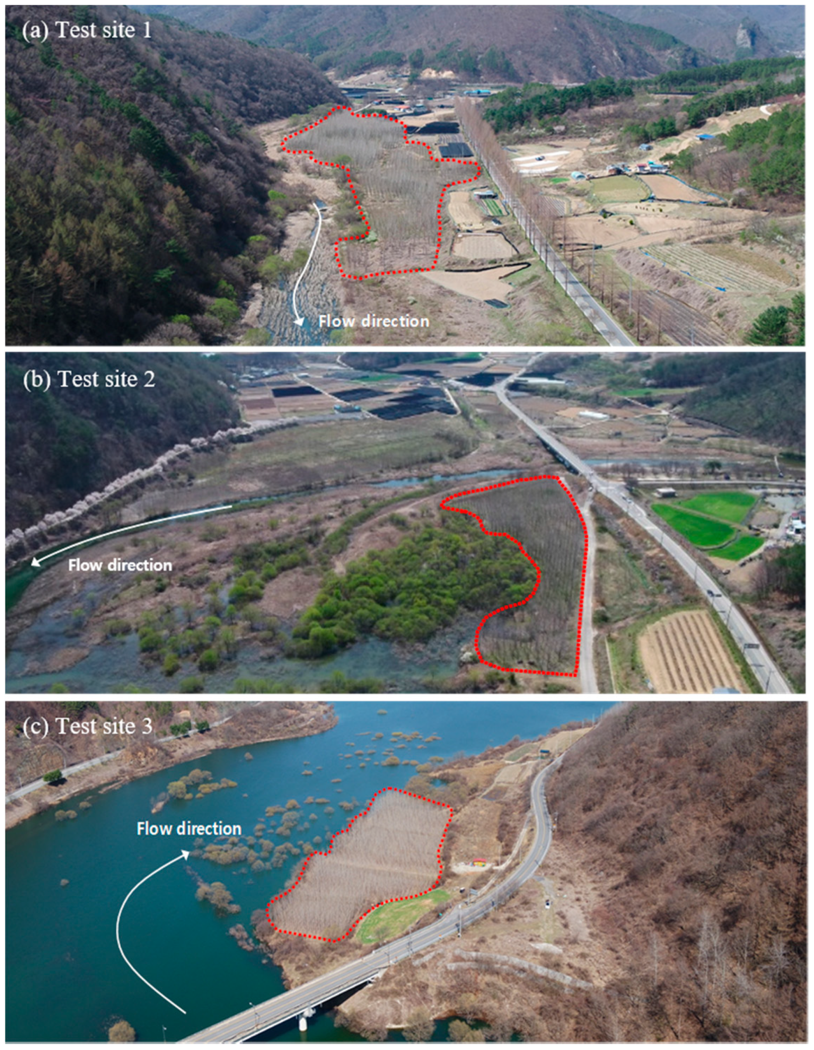
Test site 1 is a floodplain located 13 km upstream from the dam. It has a linear shape with a length of 483 m, an average width of 50 m, and an average elevation of 268 m. It is on a gentle slope with a gradient of 2.9% from the road to the river. It is on the left side of the river, and on the other side is a forest dominated by broad-leaved trees such as oaks and larches [28]. The land near this site is used for various purposes depending on the terrain, and includes farmland, road, residential area, and forest. In the farmland, ginseng, red pepper, and potatoes are cultivated, and the test site used to be a field before the poplars were planted. The soil is a sandy loam soil with a high ratio of sand to clay. The source of nonpoint source pollution was found to come from the agricultural canals of nearby farmland, residential areas, and roadside ditches pass through this test site and flow to the river.
Test site 2 is a floodplain located 18 km upstream from the dam. It has a length of 240 m and an average width of 30 m, with an average elevation of 265 m. It is on a gentle slope with a gradient of 2.7% from the road to the river. The site is located on the left bank at the river’s curve, and is more than 20 m away in horizontal distance from the usual water level line of the river. As with test site 1, it was used as a field before it was replanted with poplars. In the farmland on the right side of the river, peppers, green onions, and sesame seeds are grown on a large scale. The soil is a sandy loam soil as in test site 1. As there is no nearby farmland, the assumption was that there would be few nonpoint source pollution flowing directly into the river during rainfall, but farmland runoff on the right side of the river was found to flow through this site.
Test site 3 is a floodplain located 23 km upstream from the dam and has a length of 185 m, an average width of 55 m, and an average elevation of 264 m. It is on a relatively steep slope, with a 9.7% gradient between the road and river. It is located on the right side of the river, and there is a small farm, a road, and a forest with oaks and larches nearby [28]. The nearby farmland is small, with an area of about 100 m2. It is mostly uncultivated and was considered to generate only minimal pollution. This site was a field before the poplars were planted, and unlike test sites 1 and 2, the soil here has a high ratio of clay to sand (see Figure 4).

3.2. Soil Analysis of Test Sites

3.2.1. T-N and T-P Content in the Soil of Each Test Site

The T-N and T-P content in the soil of the 3 riparian poplar forests were compared. At each test site, 4 samples were collected from the riparian forest, 5 samples from cultivated land near the riparian forest, and 3 samples from uncultivated land. Thus, a total of 36 soil samples consisting of 12 samples from riparian forests, 9 samples from uncultivated land, and 15 samples from cultivated land were analyzed. The T-N and T-P contents in the soil at each sampling area and the mean values for each site are outlined in Table 2.
At every site, the T-N and T-P content in the soil from riparian forests were lower than those of the nearby uncultivated and cultivated land. The average T-N and T-P content in the soil from test site 1 were 0.03% and 0.005% for riparian forests, 0.133% and 0.119% for uncultivated land, and 0.22% and 0.095% for cultivated land, respectively. In test site 2, they were 0.079% and 0.031% for riparian forests, 0.076% and 0.069% for uncultivated land, and 0.134% and 0.107% for cultivated land, respectively. In test site 3, they were 0.082% and 0.073% for riparian forests, 0.101% and 0.099% for uncultivated land, and 0.167% and 0.108% for cultivated land, respectively.

3.2.2. Comparison of Mean T-N and T-P Values in Soils

The mean T-N and T-P content in the soil taken from 36 points in three sites were analyzed, and the mean T-N and T-P values of riparian forests, uncultivated land, and cultivated land were compared. The mean T-N and T-P values across all points were 0.119% and 0.079%, respectively. The mean values for the 12 points in riparian forests were 0.064% and 0.036%, respectively. The mean values for 9 points in uncultivated land were 0.104% and 0.096%, respectively. Furthermore, the mean values for 15 points in cultivated land were 0.174% and 0.103%, respectively (Table 3).
The mean T-N and T-P values of the riparian forests at site 1 were 44% and 12.5% of the T-N and T-P values averaged across all the sampling sites, respectively, thus indicating that T-N and T-P concentration was lower here than at sites 2 and 3. The mean T-N and T-P values of the riparian forest, uncultivated land, and cultivated land in site 2 were similar to the total mean values. The mean T-P value of the riparian forest in site 3 was more than twice (201.6%) the total mean, whereas the mean T-P values of the uncultivated and cultivated land were similar to the total means. In site 2, the T-N value was lower in the uncultivated land than in the riparian forest. In site 1, the T-P value was lower in the cultivated land than in the uncultivated land.

3.2.3. Significance of T-N and T-P in the Soils of Riparian Forests

(1) Normality test (Skewness and Kurtosis)
The normality of the T-N and T-P soil data collected across 36 sampling points was tested. This test verifies whether the T-N and T-P measurements in the soils of riparian forests, uncultivated land, and cultivated land satisfies the assumption of normality. The results of skewness and kurtosis were 1.171 and 1.08 for T-N and 0.089 and −0.978 for T-P, as shown in Table 4. Both T-N and T-P were found to have normality with skewness and kurtosis values between −2.0 and 2.0.
Therefore, the effect of riparian forests can be verified using the t-test, which is a parametric test, as the T-N and T-P data showed normality.
(2) T-test analysis
First, the results of the t-test on the T-N and T-P data of riparian forests and non-riparian forests were derived, and are shown in Table 5. The p-value for both T-N and T-P were lower than 0.05, indicating that the difference between the soils of riparian forests and non-riparian forests were significant (see Table 5). This indicates that riparian forests had a soil purification effect.
The riparian forest, uncultivated land, and cultivated land were compared sequentially, and the t-test results for T-N and T-P data are outlined in Table 6. The p-value between the soil of riparian forests and uncultivated land was 0.113 for T-N, indicating that the difference is not significant, but the p-value for T-P was 0.006, indicating that the difference is significant. Furthermore, the differences in the T-N and T-P content between riparian forest and cultivated land were found to be significant.

3.3. T-N and T-P Content in Poplar Biomass

3.3.1. Poplar Volume and T-N and T-P Content in Plant Bodies of Each Site

To analyze the T-N and T-P content in poplar trees, the tree height and the diameter at breast height of poplars in the sample site of each test site were first measured and analyzed. A total of 290 poplar trees were measured in the 7 sample sites across all test sites, comprising of 118, 72, and 100 trees at test sites 1, 2, and 3, respectively. The mean heights were 13.6 m, 13.8 m, and 9.8 m. The tree heights were found to be similar between sites 1 and 2, while the average tree height of site 3 was relatively low. The mean diameters at breast height were 11.3, 12.6, and 8.2 cm, respectively. The tree diameter was also relatively smaller in site 3 (Table 7).
The volume of the stem was calculated using the stem volume table prepared by the Korea Forest Service using the measured height and diameter at breast height of the poplar tree. Then the total volume of poplars at each sampling site was calculated by applying the conversion coefficient for the branch and leaf parts (1.00 for stem, 0.16 for branch, 0.02 for leaf) [29]. In addition, the T-N and T-P concentration in the poplars were calculated using the volume and the T-N and T-P measurements for each part of poplars at each site (Table 8).
The tree volumes of riparian forest sites 1, 2, and 3 were 466.40, 171.34, and 75.76 m2, respectively. Thus, the volume was greatest in site 1, which has the largest area. The volume of site 2 was approximately twice as large as that of site 3, despite both sites having the same area. An analysis of the T-N and T-P accumulation in the trees revealed that accumulation was largest in site 1, at 1493.25, and 338.18 kg, respectively. T-N and T-P accumulation in the trees in site 2 were 426.60 and 118.34 kg, respectively, a two-fold accumulation compared to site 3. In all the sites, the T-N and T-P accumulation was highest in the stem, which has the largest volume, followed by branches and then leaves.

3.3.2. Comparison of Volume Per Unit Area and T-N and T-P Accumulation in Poplars

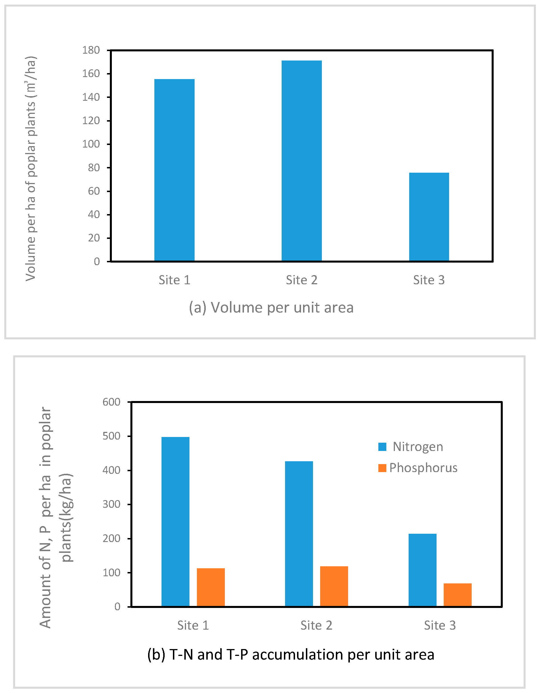
The volume of poplars per unit area (ha) and the T-N and T-P accumulation were compared among the test sites. The total mean volume per ha was 134.19 m3, and the mean volumes per ha of sites 1 and 2 were similar at 155.45 and 171.34 m3/ha, respectively. However, it was low at site 3, at 75.76 m3/ha, which is just 56.5% of the mean. The total mean value of T-N accumulation per ha was 379.59 kg, and T-N accumulation per ha in sites 1 and 2 were similar at 497.75 and 426.60 kg/ha, respectively. However, it was 214.43 kg/ha for site 3, which was only 56.48% of the mean. The total mean T-P accumulation per ha was 99.75 kg/ha, and the T-P accumulation per ha in the 3 sites were 112.73 kg/ha, 118.34 kg/ha, and 68.18 kg/ha, respectively, showing a similar trend as that of T-N (Figure 5).

3.3.3. Differences in Accumulation Rate by Poplar Plant Part

To compare the nutrient accumulation by poplar plant part, the T-N and T-P accumulation per unit volume of stem, branch, and leaf parts collected from the 7 sampling sites in the 3 riparian forest test sites were analyzed. The results generally indicated that nutrient accumulation per unit volume was relatively high in the leaf part. In the case of T-N, the highest accumulation was observed in the leaf part, with a mean value of 20.4 kg/m3, followed by branch and stem parts. The T-P accumulation was also the highest in the leaf part at 3.74 kg/m3 on average, followed by the branch and stem parts (Table 9).

4. Discussion

The comparison of average T-N and T-P values in the soil of riparian forests and nearby land reveals that the T-N and T-P values in the riparian forests were lower than in the surrounding areas. This result clearly illustrates the value of cultivating riparian forests. Regarding the question of whether or not a riparian forest is different in its ability to remove nitrogen and phosphorus from the soil compared to nearby non-riparian-forest land, this study showed that, comparatively, riparian forests can indeed remove significantly more nitrogen and phosphorous from the soil (Table 5). However, the analysis comparing T-N values from 12 points in riparian forests and nine points in uncultivated land showed that there was no significant difference between them. It can be inferred that the difference in T-N reduction many be relatively low depending on the type of crops grown in the past, the amounts of pesticide and fertilizer, and the uncultivated period. Furthermore, this result could also be due to errors in sampling and analysis.
The T-N and T-P content of the soil from the riparian forest at site 1 was 44% and 12.5% of the mean values across all the riparian forest sites, respectively, and is lower than in other test sites. This may be the result of the differences in the initial soil conditions of the test sites before poplar planting, and in the characteristics and quantity of the nonpoint source pollution that flows into the test sites. However, the tree volume of the site 1 riparian forest was higher than in other sites, and the T-N and T-P accumulation per unit area was also greatest here, at 497.75 and 112.73 kg/ha, respectively. This may be because the increase in volume of poplar trees encouraged more active absorption of nitrogen and phosphorous, which are required for growth, from the soil. In the future, the total T-N and T-P removal from the soil is expected to increase with the growth of poplar trees.
The poplar tree volume per unit area (ha) was similar between sites 1 and 2, but at site 3 it was 56% of the average value. The T-N and T-P accumulation per unit area (ha) of site 3 was also low at 56% and 68% of the average values. Sites 1 and 2 were originally used as fields, and as sandy loam soil, they have good soil properties. In addition, these two sites have a sufficient supply of the nitrogen and phosphorous required for poplar growth thanks to the pollutants flowing down the gentle slope from nearby farmlands, residential areas, and roads. In contrast, site 3 was originally used as a paddy field. It has poor soil conditions with a high ratio of clay, bad drainage and aeration, relatively few surrounding sources of pollution, and a steep slope of 9.7%. This result suggests that the environment housing the riparian forests is a critical factor that influences the growth and soil purification ability of the plants growing there.
This study found that riparian forests with poplar trees reduce nitrogen and phosphorous released into a reservoir watershed, and that nutrient inflow, as well as environmental factors like soil and terrain, are important factors that influence the effectiveness of riparian forest phytoremediation. In the future, the particular relationships between these environmental factors and the growth and purification efficiency of riparian forests with poplar trees should be analyzed, in addition to more in-depth research on the environmental and ecological values of riparian forests.

5. Conclusions

Riparian forests with poplar trees are being cultivated near waterside areas in dam floodplains to promote a system that reduces nonpoint source pollution while increasing biological habitats and biomass production. This study compared and analyzed the T-N and T-P content in the soils of riparian forests with poplar trees that cover a total area of 50,000 m2, and were planted in 2013, and the soil T-N and T-P content of cultivated and uncultivated lands. In addition, the poplar tree volume and the accumulated T-N and T-P content of the branch, stem, and leaf parts of poplars were analyzed. The findings of this study are as follows.
  • T-N and T-P values obtained from soil samples from 36 points in riparian forests established over five years ago and the surrounding areas showed normality. The T-N and T-P content of riparian poplar forests were 0.064% and 0.036%, respectively, whereas those of non-riparian forests were 0.147% and 0.101%, respectively. These differences were shown to be significant using a t-test (T-N: p < 0.009, T-P: p < 0.000). Furthermore, the difference in T-N and T-P content was also significant between poplar riparian forests and cultivated land, which were 0.174% and 0.103%, respectively. The T-N concentration in uncultivated land was 0.104%, which did not show a significant difference (p > 0.113) when compared to riparian forests. The potential cause of the significant difference of the T-N value in uncultivated land could be found in the crops grown before the land became ‘uncultivated’, the length of time the land remained uncultivated, and the cultivation method. The T-P concentration was 0.095%, and the difference was significant (p < 0.006). This result may be due to the absorption of nitrogen and phosphorous in the soil through the roots of the poplar trees.
  • The total poplar tree volume of the riparian forests was 466.46 m2 at site 1, 171.34 m2 at site 2, and 75.76 m2 at site 3. The T-N and T-P accumulation per unit area was greatest in site 1 at 497.75 and 112.73 kg/ha. The greater the volume of poplar trees per unit area, the greater the accumulation of T-N and T-P in the trees, and the lower the T-N and T-P content of the soil. The removal of T-N and T-P in the soil is expected to increase in the future when the volume increases thanks to the more active absorption of nitrogen and phosphorous, which required for poplar growth. Furthermore, when the T-N and T-P content of the branch, stem, and leaf parts of poplars were measured, the mean T-N accumulation was 0.186% for the stem, 0.687% for the branch, and 1.968% for the leaf. In addition, the mean T-P was 0.661% for the stem, 0.144% for the branch, and 0.364% for the leaf. As this investigation was carried out in October, nitrogen and phosphorous content in the leaves would have decreased before the leaves fall, and some nitrogen from the falling leaves would have been stored in the branches.
  • The average height of the poplar trees in site 3 was 9.8 m, the mean diameter at breast height was 8.2 cm, and the total volume was the lowest among the three sites. Furthermore, T-N and T-P accumulation per unit area (ha) in site 1 were 56% and 68% of the average values, respectively; both values were lower than in sites 2 and 3. This is potentially due to the difference in the crops cultivated before the poplars were planted, the soil quality, and the terrain. Therefore, if these factors are sufficiently accounted for when creating riparian forests, they may promote the growth and purification ability of the plants.
The results of this study showed that riparian forests with poplar trees had a reduction effect of T-N and T-P, demonstrating that these forests can reduce various nonpoint source pollution flowing into rivers, and help restore the lower-quality soil of cultivated lands. Riparian forests with poplar trees, which are the research theme of this study, are a nonpoint source pollution reduction system suited for ecological watershed management, and can be utilized as a form of green infrastructure. Furthermore, the environmental, social, and economic value of riparian forests will provide local communities with new tools for watershed management. We recommend that this study will lead to further research on different models of riparian forests for ecological watershed management in the future. In order to support the results of this study, hydraulic and hydrological verification is required, and further studies on pollutant purification mechanisms in plants and riparian forest functions in various floodplain environments will be conducted in the future.

Supplementary Materials

Supplementary File 1

Author Contributions

G.-S.B. designed the research and analyzed the data; B.-C.A. designed the research and collected field data. All authors have read and agreed to the published version of the manuscript.

Funding

This study was supported by the 2020 research fund from Wonkwang University.

Conflicts of Interest

The authors declare no conflict of interest. The founding sponsors had no role in the design of the study; in the collection, analyses, or interpretation of data; in the writing of the manuscript; and in the decision to publish the results.

References

  1. Mendlik, T.; Gobiet, A. Selecting climate simulations for impact studies based on multivariate patterns of climate change. Clim. Chang. 2016, 135, 381–393. [Google Scholar] [CrossRef] [PubMed] [Green Version]
  2. Ribaudo, M.; Jorge, D.; LeRoy, H.; Michael, L.; Roberto, M.; James, W. Nitrogen in Agricultural Systems: Implications for Conservation Policy. USDA-ERS Economic Research Report No. 127. 2011. Available online: https://papers.ssrn.com/sol3/papers.cfm?abstract_id=2115532 (accessed on 7 May 2020).
  3. Davidson, E.A.; David, M.B.; Galloway, J.N.; Goodale, C.L.; Haeuber, R.; Harrison, J.A.; Peel, J.L. Excess nitrogen in the US environment: Trends, risks, and solutions. Issues Ecol. 2011, 15. [Google Scholar]
  4. Su, X.; Wang, H.; Zhang, Y. Health risk assessment of nitrate contamination in groundwater: A case study of an agricultural area in Northeast China. Water Resour. Manag. 2013, 27, 3025–3034. [Google Scholar] [CrossRef]
  5. Galloway, J.N.; Schlesinger, W.H.; Levy, H.; Michaels, A.; Schnoor, J.L. Nitrogen fixation: Anthropogenic enhancement-environmental response. Glob. Biogeochem. Cycles 1995, 9, 235–252. [Google Scholar] [CrossRef] [Green Version]
  6. Howarth, R.W.; Billen, G.; Swaney, D.; Townsend, A.; Jaworski, N.; Lajtha, K.; Downing, J.A.; Elmgren, R.; Caraco, N.; Jordan, T.; et al. Regional nitrogen budgets and riverine N & P fluxes for the drainages to the North Atlantic Ocean: Natural and human influences. In Nitrogen Cycling in the North Atlantic Ocean and Its Watersheds; Springer: Dordrecht, The Netherlands, 1996; Volume 35, pp. 75–139. [Google Scholar]
  7. Parris, K. Impact of agriculture on water pollution in OECD countries: Recent trends and future prospects. Int. J. Water Resour. 2011, 27, 33–52. [Google Scholar] [CrossRef] [Green Version]
  8. OECD. Environmental performance of agriculture—Indicators. OECD Agric. Stat. (Database) 2020. [Google Scholar] [CrossRef]
  9. Dwire, K.A.; Lowrance, R.R. Riparian ecosystems and buffers-multiscale structure, function, and management: Introduction. J. Am. Water Resour. Assoc. 2006, 42, 1–4. [Google Scholar] [CrossRef]
  10. Jobin, B.; Belanger, L.; Boutin, C.; Maisonneuve, C. Conservation value of agricultural riparian strips in the Boyer River watershed, Quebec (Canada). Agric. Ecosyst. Environ 2004, 103, 413–423. [Google Scholar] [CrossRef]
  11. Browder, G.; Ozment, S.; Rehberger Bescos, I.; Gartner, T.; Lange, G.M. Integrating Green and Gray: Creating Next Generation Infrastructure; World Bank and World Resources Institute: Washington, DC, USA, 2019; Available online: https://openknowledge.worldbank.org/handle/10986/31430 (accessed on 3 May 2020).
  12. Haase, D. Urban wetlands and Riparian forests as a nature-based solution for climate change adaptation in cities and their surroundings. In Nature-Based Solutions to Climate Change Adaptation in Urban Areas; Springer: Cham, Switzerland, 2017; pp. 111–121. [Google Scholar]
  13. Dix, M.E.; Klopfenstein, N.B.; Zhang, J.W.; Workman, S.W.; Kim, M.S. Potential use of Populus for phytoremediation of environmental pollution in riparian zones. USDA For. Serv. Gen. Tech. Rep. 1997, 297, 206–211. [Google Scholar]
  14. Ebbs, S.D.; Lasat, M.N.; Brady, D.J.; Cornish, J.; Gorden, R.; Kochian, L.V. Phytoextraction of cadmium and zinc from a contaminated soil. J. Environ. Qual. 1997, 26, 1424–1430. [Google Scholar] [CrossRef]
  15. Yeo, J.K.; Woo, K.S.; Koo, Y.B.; Kim, Y.S. Growth performance and adaptability of Three-year-old poplar and willow clones in a riparian area. J. Korean Soc. Environ. Restor. Tech. 2007, 10, 40–50. (In Korean) [Google Scholar]
  16. FAO. Poplars and willows in wood production and land use. FAO For. Ser. 1980, 10, 328. [Google Scholar]
  17. Dickmann, E.I.; Isebrands, J.G.; Eckenwalder, J.E.; Richardson, R. An overview of the genus Populus. In Poplar Culture in North America Part A; NRC Research Press: Ottawa, ON, Canada, 2001; p. 397. [Google Scholar]
  18. Isebrands, J.G.; Karnosky, D.F. Environmental benefits of poplar culture. In Poplar Culture in North America Part A; NRC Research Press: Ottawa, ON, Canada, 2001; pp. 207–218. [Google Scholar]
  19. Westphal, L.M.; Isebrands, J.G. Phytoremediation of Chicago’s brownfields-consideration of ecological approaches and social issues. In Brownfields 2001 Proceedings; United States Department of Agriculture: Chicago, IL, USA, 2001. [Google Scholar]
  20. Liu, Y.; Yang, W.; Wang, X. GIS-based integration of SWAT and REMM for estimating water quality benefits of riparian buffers in agricultural watersheds. Trans. ASABE 2007, 50, 1549–1563. [Google Scholar] [CrossRef]
  21. Inamdar, S.P.; Lowrance, R.R.; Altier, L.S.; Williams, R.G.; Hubbard, R.K. Riparian Ecosystem Management Model (REMM): II. Testing of the water quality and nutrient cycling component for a coastal plain riparian system. Trans. ASAE 1999, 42, 1691. [Google Scholar] [CrossRef]
  22. Lowrance, R.; Altier, L.S.; Williams, R.G.; Inamdar, S.P.; Sheridan, J.M.; Bosch, D.D.; Hubbard, R.K.; Thomas, D.L. REMM: The riparian ecosystem management model. J. Soil Water Conserv. 2000, 55, 27–34. [Google Scholar]
  23. Ryu, J.; Cho, J.; Kim, I.J.; Mun, Y.; Moon, J.P.; Kim, N.W.; Kim, S.J.; Lim, K.J. Enhancement of SWAT-REMM to simulate reduction of total nitrogen with riparian buffer. Trans. ASABE 2011, 54, 1791–1798. [Google Scholar] [CrossRef]
  24. Choi, Y.H.; Ryu, J.C.; Hwang, H.S.; Kum, D.H.; Park, Y.S.; Jung, Y.H.; Choi, J.D.; Lim, K.J. Analysis of pollutant load reduction efficiency with Riparian buffer system Using the SWAT-REMM. J. Korean Soc. Water Environ. 2015, 31, 166–180. (In Korean) [Google Scholar] [CrossRef] [Green Version]
  25. Yeo, J.K.; Lee, W.W.; Koo, Y.B.; Woo, K.S.; Byun, J.K. Nitrogen Storage Potential in Aboveground Biomass of Three-year-old Poplar Clones in a Riparian Area. J. Agric. Life Sci. 2010, 44, 15–21. (In Korean) [Google Scholar]
  26. Weather Go. Available online: http://www.kma.go.kr (accessed on 2 June 2020). (In Korean).
  27. My Water: K-Water. Available online: http://www.water.or.kr (accessed on 2 June 2020). (In Korean).
  28. Forest Geospatial Information Services. Available online: http://map.forest.go.kr (accessed on 2 June 2020). (In Korean).
  29. Korea Forest Service. Forest Volume, Biomass and Harvest Manual. 2017. Available online: https://www.montrealprocess.org/documents/publications/general/2014/KoreaNationalReportForSFM2014.pdf (accessed on 2 June 2020).
Figure 1. The study area.
Sustainability 12 06871 g001
Figure 2. Process of planting poplars (photographs of planting process in three sites).
Sustainability 12 06871 g002
Figure 3. Research method and flow.
Sustainability 12 06871 g003
Figure 4. Riparian forests in waterside areas near the dam lake: (a) UAV photograph of Unbong-ri, Jucheon-myeon, (b) Wolpyeong-ri, Jeongjeon-myon, and (c) Galhyeon-ri, Sangjeon-myeon.
Sustainability 12 06871 g004
Figure 5. Comparison of volume per unit area and T-N and T-P accumulations in poplars.
Sustainability 12 06871 g005
Table 1. Area and size of riparian forests by site.
Site 1Site 2Site 3
●SpeciesPopulus deltoides
Populus deltoides ×
P. nigra
Populus deltoides
Populus deltoides ×
P. nigra
Populus deltoides
Populus deltoides ×
P. nigra
●Planted area (m2)30,00010,00010,000
●Planted quantity700025002500
Table 2. Soil analysis measurements of each test site.
Point of InvestigationSite 1Site 2Site 3
T-N (%)T-P (%)T-N (%)T-P (%)T-N (%)T-P (%)
MeasureMeanMeasureMeanMeasureMeanMeasureMeanMeasureMeanMeasureMean
Poplar forest10.0470.0300.0010.0050.0020.0790.0010.0310.1600.0820.0920.073
20.0350.0080.1660.0510.0590.073
30.0070.0010.0740.0170.0470.062
40.0300.0080.0720.0550.0630.064
Uncultivated50.1300.1330.1600.1190.0320.0760.1400.0690.1900.1010.1800.099
60.1200.1010.1150.0120.0520.055
70.1500.0960.0810.0550.0620.062
Cultivated80.2300.2200.1520.0950.3200.1340.0630.1070.3700.1670.1100.108
90.3300.0450.0430.0690.0890.077
100.1500.0200.0580.1140.0970.105
110.1900.1190.0480.1280.1380.125
120.2000.1410.2000.1600.1400.123
Table 3. Mean T-N (Total Nitrogen) and T-P (Total Phosphors) content in each site.
Site 1 (%)Site 2 (%)Site 3 (%)Mean (%)
abcabcabcabc
T-N0.0300.1330.2200.0790.0760.1340.0820.1010.1670.0640.1040.174
T-P0.0050.1190.0950.0310.0690.1070.0730.0990.1080.0360.0960.103
Group a: Riparian forests; b: Uncultivated land; c: Cultivated land.
Table 4. T-N and T-P normality test.
NMeanSDVarianceSkewnessKurtosis
T-N360.1190.0900.0081.171.08
T-P360.0790.0510.0030.089−0.978
Table 5. T-test verification (between riparian forest and non-riparian forest).
GroupNMeanSDtp-Value
T-NA120.0670.048−2.7790.009
B240.1470.093
T-PA120.0360.033−4.3430.000
B240.1010.046
Group A: Riparian forest area; B: Non-riparian forest area (uncultivated land, cultivated land).
Table 6. T-test verification (among riparian forests, uncultivated land, and cultivated land).
GroupNMeanSDtp-Value
T-Na120.0670.048−1.6640.113
b90.1040.051
a120.0670.048−3.2590.003
c150.1740.104
T-Pa120.0360.033−3.0690.006
b90.0950.055
a120.0360.033−4.6540.000
c150.1030.040
Group a: Riparian forests; b: Uncultivated land; c: Cultivated land.
Table 7. Growth characteristics of six-year-old poplar trees sampled to estimate growth at test forest plantation in the riparian zone of the Yongdam Reservoir.
SitePlanted Area (m2)SampleNumber of TreesHeight (m)DBH (cm)
NumberArea (m2)
Site 130,000360011813.6 ± 1.44
(11~16)
11.3 ± 3.49
(6~20)
Site 210,00024007213.8 ± 0.97
(12~15)
12.6 ± 3.88
(6~22)
Site 310,00024001009.8 ± 0.82
(9~12)
8.2 ± 1.83
(6~14)
Note: Height and DBH are shown as mean ± S.D. The values in parenthesis are ranges. DBH is the diameter at breast height.
Table 8. Volumes of trees and T-N and T-P content (mass) for each site.
SiteArea (ha)PartVolume (m3) (1)T-N Ratio (%)T-P Ratio (%)N (kg) (2)P (kg) (2)
Site 13.00Total466.401493.25338.18
Stem395.250.240.06967.05235.83
Branch63.240.530.11333.0668.09
Leaf7.912.440.43193.1534.26
Site 21.00Total171.34426.60118.34
Stem145.200.140.05196.0270.42
Branch23.230.780.17180.0538.33
Leaf2.901.740.3350.539.58
Site 31.00Total75.76214.4368.18
Stem64.200.180.07114.2847.51
Branch10.270.760.1678.0716.44
Leaf1.281.720.3322.084.24
(1) Volume (m3) = stem volume × coefficient (1.00 for ‘stem’, 0.16 for ‘branch’, 0.02 for ‘leaf’). (2) Mass of N, P (kg) = volume (m3) × ton/m3 × ratio (%) of T-N and T-P × 1000.
Table 9. Comparison of T-N and T-P accumulations by part of poplar trees.
Sample NT-N (kg/m3)T-P (kg/ m3)
MeanSD.Min.Max.MeanSD.Min.Max.
Stem71.941.550.765.100.610.310.301.10
Branch76.641.724.108.901.390.320.931.70
Leaf720.45.4013.1028.103.741.412.206.30