Case Report

A Large-Scale Nature-Based Solution in Agriculture for Sustainable Water Management: The Lake Karla Case

by
Yiannis Panagopoulos
* and
Elias Dimitriou
Hellenic Centre for Marine Research, Institute of Marine Biological Resources and Inland Waters, 19013 Anavissos Attikis, Greece
*
Author to whom correspondence should be addressed.
Sustainability 2020, 12(17), 6761; https://doi.org/10.3390/su12176761
Submission received: 16 July 2020 / Revised: 14 August 2020 / Accepted: 18 August 2020 / Published: 20 August 2020
(This article belongs to the Special Issue Sustainable Planning and Management of Water Resources in Agriculture)

Abstract

:
This study demonstrates a new nature-based solution (NBS) project in agriculture, the ‘Karla’ reservoir in Central Greece, a unique example at European scale, of a lake ecosystem which was dried and is now restored with the purpose to maximize the efficiency of water provision in agriculture and biodiversity enhancement. In this article, we present: (a) The historical developments from the existence of the old natural Lake Karla until the reconstruction of the homonymous artificial reservoir, (b) the environmental and economic benefits that the new project delivers, and (c) the governance and management mechanisms that can ensure the efficient operation of the project. The analysis shows that the reconstructed Lake Karla can serve as a multi-purpose project to combat water scarcity, achieving a twofold crop yield production and respective agricultural income in the surrounding area, securing the coverage of the water supply needs of the closest city, improving the status of groundwater resources, developing a natural shelter for biodiversity and emerging recreation and touristic opportunities. At the same time, its construction and operation costs can be recovered, and the proposed governance plan can ensure the viability of the whole project inspiring similar multi-purpose water retention projects for investment in agriculture and the environment in southern Europe but also in other water scarce regions.

1. Introduction

1.1. Context and Case

The European Union (EU) Water Framework Directive (WFD) requires that member states ensure that water bodies achieve “good status for surface and groundwater” [1]. This implies that no environmental degradation occurs, and sustainability is restored or maintained. Probably the main sector responsible for water bodies’ degradation in southern Europe is agriculture, accounting for around 80% of total water use [2]. This is the case for Greece, where irrigation of crops accounts for virtually all agricultural water use, which in some cases has reached unsustainable levels [3]. The latest European environmental monitoring results prove that water scarcity conditions and drought events continue to cause significant risks in southern Europe, where agriculture remained the sector exerting the highest pressure on renewable freshwater resources overall in 2017. Agriculture was responsible for 59% of total water use in Europe that year, mainly because of the extreme percentages in southern Europe [4].
Nature-based solutions (NBSs) to collect, store, and distribute water in water scarce agricultural regions of the Mediterranean, are gaining ground as they enhance the availability and quality of water for productive purposes and human consumption, while they preserve the integrity and intrinsic value of the ecosystems [5]. According to the EU definition [6]: “NBSs are inspired and supported by nature, are cost-effective, they simultaneously provide environmental, social and economic benefits and help build resilience”. With NBSs, healthy, resilient, and diverse ecosystems (whether natural, managed, or newly created) can provide solutions for the benefit of societies and overall biodiversity.
The present study focuses on a NBS at the water scarce eastern part of the agricultural Pinios River basin (~10,800 km2) in Central Greece, the newly created Karla reservoir within the Karla basin, a subbasin of Pinios River basin as shown in Figure 1. Pinios River basin covers a large part of the River Basin District (RBD) of Thessaly in Central Greece (Figure 1), the most important agricultural producer in the country, where dry summers inversely affect agriculture resulting in irrigation cutbacks, overexploitation of groundwater, and significant losses of crop yields [7,8,9,10]. The main irrigated (and subsidized) crop is cotton, which, despite the water shortage threat, remains the engine of the local agricultural economy.
Karla was a natural lake until 1962, when it was drained, and was considered an important ecosystem in the Mediterranean region as it served as a “hot spot” of biodiversity, and as a natural reservoir providing water storage and recharge to groundwater [11]. Experiencing negative consequences from its drainage, the authorities decided to restore the lake. The new project is today an artificial reservoir as shown in Figure 2 in the same place of the old natural Lake Karla. The new Lake Karla (latitude 39°26′49″ to 39°32′03″ N, longitude 22°46′47″ to 23°51′50″ E [12]) has already been characterized as a vital aquatic ecosystem, being a Natura and Ramsar site, and a functional multi-purpose reservoir [13], which, by trapping natural winter runoffs and water diversions from Pinios River, will be able to protect adjacent lowland areas from flooding, irrigate nearby crops during the dry seasons, and provide water supply to the closest city of Volos (Figure 1). Actually, it was the dry season of 2019 when the Karla reservoir provided irrigation water for the first time to the farmers of a considerable area around it, proving that after a long period of delays and postponements, this large project is ready to operate according to its original plan.

1.2. Background

The Pinios basin is characterized by cold and wet winters but hot and dry summers. The Lake Karla basin suffers more from water scarcity than any other subregions within Pinios basin with an average annual precipitation of 560 mm [14]. Agriculture is by far the main water consumer representing 90–95% of the annual water demand in the Pinios basin, with irrigated land covering half of the total cultivated area (400,000 ha). Cotton is the main crop cultivated, with high water demands (500 mm or 5000 m3/ha water per growing season), followed by maize and alfalfa. Wheat occupies an area almost equal to cotton’s and is not irrigated. Irrigation water is abstracted mostly from groundwater sources which, in most cases, has reached unsustainable levels. This has made groundwater more expensive to obtain (deep pumping) and has caused saline water intrusion in the eastern coastal areas [8,9].
Part of the irrigated land in Pinios River basin has been divided into irrigation districts managed by the Local Organizations of Land Reclamation (LOLRs). As reported in a study of last decade, only 40% (76,950 ha) of the irrigated land is being irrigated through collective irrigation networks supplied mainly by boreholes, under the jurisdiction of the LOLRs [15]. On the contrary, the rest are irrigated through private boreholes. According to the pricing regime for collective networks, farmers pay a very small operation fee depending on the size of land they irrigate, the area-based payment, on top of the high energy cost of pumping which is shared among them. Other farmers hold private boreholes and undertake the cost of their operations individually. In any case, the operation and maintenance costs are relatively high, mainly because of significant energy costs due to deep groundwater levels [15]. According to a survey in the 2000s, the majority of farmers in the Thessaly region have stated an annual income between €5000 and €20,000, with an average income of approximately €16,000, and much more prosperous farmers with annual incomes reaching up to €70,000 [16]. A more recent study which focused exclusively on the Lake Karla basin (Figure 1) agrees with these numbers [17].
Until the 1960s, Lake Karla was a wetland of irregular shape, fluctuating between 40 km2 and 180 km2, which, on the one side supported a variety of habitats [18] and a rich fish fauna [19], essential for rural households both as income and food security [20], but on the other side, it flooded thousands of hectares of fertile land. The need for additional land was the main reason for draining the lake in 1962, when the local economy had already turned to agriculture. Moreover, the loss of fisheries was noteworthy as peak production was over 1390 tons of fish in 1917, decreasing to just over 500 tons in the early 1950s [21]. Finally, from the early 20th century, Karla had been considered the primary cause of human disease and high death rates due to malaria and other diseases, which were linked specifically with wetlands [20]. Hence, in 1953 the Ministry of Agriculture suggested the lake’s partial drainage. The decision was taken in 1959, and the lake was completely drained in 1962 through a tunnel to Pagasitikos Gulf (Aegean Sea to the east, see Figure 1).
However, quite early after the lake’s drainage, the consequences proved terrible as the area started experiencing a number of anthropogenic impacts. Lots of hectares of arable crops, followed by tree cultivation and vineyards, had been irrigated under no viable rules of groundwater exploitation leading to significant drawdown of groundwater levels, soil salinization, as well as intrusion of saltwater in the eastern part of the basin. Pumping had become extremely expensive, even technically infeasible, from very large depths. Grazing that was also taking place all around the area covered by the former lake providing employment, producing meat, eggs, wool, milk, cheese, and other dairy items was also impacted by water scarcity. The whole basin area experienced persistent droughts during the periods from mid to late 70s, from late 80s to early 90s, and in the first years of the 2000s [22]. The local economy was affected through lower family income and higher social instability associated with reduced crop production and elimination of fisheries [14]. The area lost its ecological and aesthetic value, large populations of migratory birds disappeared, and the area’s microclimate was affected, leading to increased frost, cracks in the land, and lower humidity levels, followed inevitably by land abandonment [20].

1.3. The Re-Construction Project

The benefits of restoring Lake Karla were deeply realized. Restoration efforts were started by the Ministry of Environment, Physical Planning and Public Works in the 80s, addressing the re-establishment of a new functional reservoir and wetland. In the late 90s the restoration scenario was updated taking into consideration the need for an effective wetland functioning, thus incorporating the general principles and guidelines for wetland restoration practices by the Ramsar Convention [11,23]. The final restoration decision was taken in 2000 by the Greek government, the costs being partially covered by the European Union’s operational program “Environment” (structural funds) which was approved by the European Commission for the period 2000–2006 [14].
The new reservoir is now situated at the lowest part of the former wetland and is maintained through the construction of two 9 m-high dikes. Through pumping stations, drainage ditches, and four rainwater collectors, surface runoff water from the higher elevation zones of the upper basin is diverted into the reservoir. The project also includes the water supply works to Volos, irrigation networks for approximately 90 km2, flood control works, artificial wetland constructions (three manmade islands and a shallow wetland area of 0.45 km2 for bird nesting and the reproduction of fish), landscape and ecosystem management, as well as new infrastructure aimed at the development of ecotourism and other recreational activities. According to the lake’s water budget assessments, the additional water required annually from the Pinios River during the winter season is around 90 hm3 [24] and was calculated by adding both the estimated needs of irrigated agriculture (40–50 hm3/y) and drinking water supply to the Volos area (10 hm3/y), but also the necessary water quantities for continuous water availability in the lake that can ensure its environmental and ecological functions including its capability to recharge the aquifer. The diversion from Pinios is achieved by a network of ditches (shown on Figure 1).
The re-constructed Lake Karla has a surface of 38 km2. It is designed to store water up to a maximum water depth of 4.5–5 m (corresponding to 180–200 × 106 m3 of water), while the depth of 2–2.5 m (volume of water < 100 × 106 m3) corresponds to the minimum water level of the reservoir, which is considered the ecological threshold, allowing the lake to satisfy the ecological criteria as a wetland. So, the maximum allowable volume of the reservoir can approach 200 × 106 m3, but only half of it can be extracted. For security reasons, under an emergency situation of extremely wet conditions, an artificial tunnel can remove waters from the lake to the Pagasitikos Gulf.
Lake Karla is listed in the network of the Greek protected areas as it is considered a vital aquatic ecosystem in terms of biodiversity but also as a newly re-established water resource accommodating multiple uses. It is a Natura site, a site of community importance for the conservation of natural habitats and of wild fauna and flora with the code GR 1420004 “Karla-Mavrovouni-Kefalovriso-Velestino-Neohori”, a Ramsar site, and a special protection area for the conservation of wild bird species, with the code GR 1430007 “Reservoir area of former Lake Karla”. It has been characterized as a permanent wildlife refuge in order to protect and conserve habitats, essential breeding, feeding areas, wintering species of wild fauna, and spawning and nursery areas of fish of commercial and conservation importance [13]. In 2003 the Managing Authority or Management Body of the eco-development area of ‘Karla-Mavrovouni-Kefalovriso-Velestino-Neohori’ was established with the scope to protect, conserve, and manage the area’s natural and cultural resources.

1.4. Purpose of the Study

The purpose of the present study is to combine environmental, cost, hydrologic, and crop growth modeling and other data for the study area in order to evaluate the delivered benefits from the construction of the Lake Karla NBS and propose an operation plan, able to ensure the viability of the project in the long-term.

2. Materials and Methods

2.1. Model Setup of the Pinios-Karla Hydrologic System

A modeling system of Pinios basin represented the hydrology, water management, and crop productivity within the Pinios River basin under two scenarios: (A) With the operation of Lake Karla and (B) without the existence of the lake. This distinction can help quantify the benefits of reconstructing the lake, specifically with respect to the crop production and water availability within the surrounding water bodies. Between many existing simulation tools, the SWAT (Soil and Water Assessment Tool) model [25,26] was selected to address the issues of interest in this study. SWAT is the most widely-used tool in addressing topics of river basin management, from water management within basins to water quality of streams, rivers, and other water bodies [27,28,29]. It was developed by the US Department of Agriculture in collaboration with Texas A&M University [26]. A recent release of SWAT version 2012 (SWAT 2012, revision 664) in combination with the ArcGIS (version 10.4) SWAT (ArcSWAT) interface [30] were used in this study. Specifically, we updated an already established SWAT Pinios River basin model [8,9] to the newest version and applied the aforementioned scenarios (with and without Lake Karla). In this work, we take advantage of the comprehensive parameterization and calibration/validation already conducted only a few years ago with representative land uses and water management practices, to focus on parts of the Pinios basin hydrologic system: Lake Karla and its surrounding area.
SWAT offers a distributed modeling, as a basin is delineated into subbasins and subsequently into hydrologic response units (HRUs), which represent homogeneous combinations of land use, soil types, and slope classes in each subbasin. The physical processes associated with water and sediment movement, crop growth, and nutrient cycling are modelled at the HRU scale; runoff and pollutants exported from the different HRUs are routed downstream. Simulation of the hydrology is separated into the land (water balance equation in the soil profile) and the routing phase of the hydrologic cycle. A reservoir in SWAT is simulated by assigning the volume of water and the area covered by water at two critical points: The water level at the principal and the emergency spillways, while its water balance is simulated by considering precipitation, evaporation, inflows, abstractions, seepage, and overflowing. SWAT incorporates a crop growth component, which is capable of simulating a wide range of crop rotation, grassland/pasture systems, and trees. In the model, potential crop growth and yield are usually not achieved as they are inhibited by temperature, water, and nutrient stress factors [31].
The Pinios River basin model including Lake Karla’s basin was initiated with the use of a 25 × 25 m Digital Elevation Model to delineate the study area (10,599 km2) and the river network, with the basin being divided into 49 subbasins as shown in Figure 3. A land use map, providing the areas of each crop per municipality was developed based on a CORINE Land Cover (CLC) 2000 layer [32] and Farm Structure Survey (FSS) data referring to the year 2000, while a soil map including mainly clay and clay-loamy soils was developed by analyzing data layers provided by the National Institute of Soil Mapping and Classification [9]. The overlay of those maps led to the schematization of 361 HRUs (average area: 1 HRU = 30 km2), which is more attributed to land use heterogeneity. The irrigated crops included in the model were cotton (80%), alfalfa, and corn.
An HRU in SWAT can use as source for irrigation the aquifer, an outside source, the river, or a reservoir. If there is not adequate water in the water body, irrigation is applied up to the amount of water available. An extensive identification of the irrigation source has been done for all irrigated areas in the basin [8,9] and transferred to this study. One of the reservoirs is the Karla reservoir, located in subbasin 47 (Figure 3), which is planned to provide irrigation water to ~90 km2 (9000 ha) per year in the adjacent areas and was added to the model at subbasin 47. The Karla reservoir in the Pinios model serves as the single source of irrigation water for approximately 8000 ha of irrigated cotton areas of subbasin 47, which are sufficiently close to the planned 9000 ha. However, this was considered as a realistic deviation from the originally planned irrigated area, given the uncertainties in completing the irrigation networks. Water inflows to Karla reservoir arise from precipitation, inflows from the natural drainage of the upstream subbasin 47 but also the artificial delivery of runoff generated in subbasins 48 and 49, mimicking trapping to the lake through small pumping stations and collector channels. The greatest part of water inflows to the Karla reservoir arises from the constant water diversions from the Pinios River within the period October–April at a rate of 5 m3/s, resulting to the planned diverted water volume of 90 hm3/y [24,33].
For the optimum irrigation of the row crops in the basin, dominated by cotton, a full growing season requires 500 mm (5000 m3/ha) of applied water through ~10 irrigation doses between May and September. Thus, in our modelling the total water amounts abstracted from Karla reservoir each year for irrigating the 8000 cotton hectares of subbasin 47 (see Figure 3) were calculated based on the amount of 5000 m3/ha resulting to a seasonal water abstraction of 40 hm3. An additional outflow from the lake was the water supply of Volos city with the amount of 10 hm3 which was uniformly distributed within the year [24]. Furthermore, overflows outside the basin (to the sea in reality) are simulated in SWAT when, by calculating the water budget, excess water occurs. Other intentional outflows from the reservoir do not occur (e.g., water to maintain ecological flows downstream) but only evaporation from the lake’s surface and water losses through seepage from its bottom. Evaporated water is calculated based on weather inputs, while seepage based on the rate of 0.1 mm/h defined in the model, resulting to almost 33 hm3 of water enriching the aquifer on an annual basis. Table 1 summarizes the Karla reservoir’s geometric characteristics and water flows as defined in our Pinios basin SWAT model.
Water level should remain above the threshold of 2.5 m in Lake Karla. Given the 38 km2 water area of the lake, this corresponds to a minimum water volume of almost 100 hm3. On the other hand, water can rise up to 5 m in the reservoir increasing its water storage to ~200 hm3. Water quantities above this threshold are considered flooded water that is transported outside the lake.
The model has been calibrated based on available river flows for several river sites along Pinios and its tributaries [34] and reported crop yields. Mean cotton yields were simulated close to 4 t/ha/y, while those of corn and alfalfa were both estimated near 11 t/ha/y with small spatial variations, very close to reported values. The Pinios SWAT model calibration has been satisfactory, as described in Panagopoulos et al. [8,9].
From a 35-y series of available meteorological data we use the most recent decade available (2001–2010) in this study, which is also the period our land use parameterization, including crop allocation, refers to. To appropriately represent the existing limited groundwater availability in the Pinios basin, initial water content of the shallow aquifers at the beginning of the simulation is neglected. So, groundwater availability in every year of simulation depends only on the annual natural water replenishment. This results to annual groundwater abstractions equal to recharge representing abstractions of the renewable groundwater reserves only without over-exploitation. In areas across Pinios basin with high concentration of crop areas, this can represent inadequate crop irrigation, a non-desired but suitable practice of groundwater exploitation, which is necessarily the case due to water shortage. Thus, the overall conceptualization of groundwater exploitation with SWAT forced the model to apply a reduced irrigation amount from the user-defined theoretical (optimum) demand of 500 mm (5000 m3/ha) in parts of the Pinios basin ensuring a realistic simulation [8,9]. According to the calibrated SWAT Pinios basin model, the highest deficit in irrigation water occurred in the southern and central parts of the basin with lower precipitation and extensive irrigated areas, where the actually applied irrigation water was significantly lower than the theoretical demand of 500 mm defined in the model. In contrast, irrigation needs in the western part of Pinios basin were totally covered by the existing water resources and this was also the case for all areas served by surface water reservoirs, including the Lake Karla basin [8,9]. In the present work that focuses on the Karla basin to estimate the benefits of the Lake Karla project, the existing Pinios basin model was also executed without Lake Karla. Specifically, this scenario assumed that the lake does not exist, thus no water transfer from Pinios River occurs, runoff waters from the Karla basin’s areas are routed naturally to the nearby streams, the area occupied by the lake is fallow, and irrigation of the 8000 ha of cropland in subbasin 47 (Figure 3) is satisfied by local groundwater abstractions based on the aquifer’s annual natural replenishment, as described above. The calibrated model was executed with those changes and both irrigation amounts applied to Karla basin’s agricultural area (subbasin 47 in Figure 3) and crop yields were updated, along with the water budget of the area and the simulated Pinios River flows downstream from the diversion point (see Figure 1).

2.2. Costs and Financing

The restoration project of Lake Karla was funded by the European Regional Development Fund (ERDF) and national contributions. Specifically, it began to be implemented through national resources and co-financing from the third Community Support Framework (CSF) and the operational program “Environment,” and continued with resources of National Strategic Reference Framework (NSRF) 2007–2013 and the operational program of the Region of Thessaly structural funds. The total cost of the restoration was about €245,000,000, including cost of the design study of the project, expropriation of land, and construction costs including materials and labor. Specifically, this cost includes the formation of the new lake along with the collector channels and pumping stations, as well as all the subprojects associated with the works of diverting water from Pinios to Karla, water supply from the lake to the city of Volos, the flood proofing (embankments all around the reservoir and tunnel for transport of overflows to the sea), irrigation works for the distribution of the irrigation water to the arable land, and works associated with the development of rural tourism [17,24]. The specific costs are summarized in Table 2.
For costing the Lake Karla project on an annual basis the total investment cost is annualized based on the following formula:
A E C = r ( 1 + r ) n ( 1 + r ) n 1 × I + O M C
where AEC is the annual equivalent cost, I is the investment costs (€245,000,000), which, despite delays in completing the different phases of the project, is assumed to represent the total actual investment cost of the project; OMC are the operational and maintenance costs related to the investment; r is the interest rate; and n is the useful life of the project [35]. In practice, the cost of the Lake Karla project, which represents a loan taken from banks, is spread over the next years, with Equation (1) calculating the mortgage payments or the equivalent uniform annual worth of the project for the next n years [36], increased by a stable annual operational/maintenance cost. Both OMC and the interest rate are uncertain, thus, Equation (1) is evaluated for OMC equal to 1%, 2%, and 3% of the investment cost and interest rates of 2%, 3%, and 5% and for a 50-y life time, typical for large projects. Table 3 summarizes the AECs resulted by combining various OMCs and interest rates.
From the combination of OMCs and interest rates above the AECs range between 10 and almost 21 M€, with the majority of the more realistic combinations with OMC ≥ 2%, being concentrated within the smaller range of 13–18 M€. An AEC of around €15,000,000, which corresponds to an OMC of 3% and interest rate of 2% and vice versa can be a good approximation of the annual target for cost recovery.
Other types of costs needed in the analysis include data related to the annual crop yield prices and pumping expenses, which are related with the farmers’ income. In practice, by operating the Lake Karla project, increase of crop yields without pumping is expected to benefit the farmer community. We assume that other cultivation costs such as fertilizers, pesticides, use of machinery for other agricultural practices in the farm fields, etc., do not change due to the operation of Lake Karla. Therefore, for the needs of the present study, what has to be used is the price of cotton yield in recent years (0.40–0.50 €/kg) as officially reported by the Greek Ministry of Rural Development and Food [37] and the water pumping cost. As far as the latter is concerned, we rely on the knowledge gained during a very recent visit to the study area where local farmers around the Lake Karla area complained about the high irrigation cost of 500 €/ha due to the high energy (electricity) consumption required to pump water.

3. Results

3.1. Modelling Outputs

The SWAT model produced monthly and annual results for a 10-y period for both scenarios: (A) With the Lake Karla in place (baseline scenario) and (B) without the lake in the most southeastern part of the Pinios basin. Among the results of interest are the monthly/annual flows of the Pinios River, the irrigation amounts applied to the agricultural areas along with the crop yields, as well as the water budget of Lake Karla in Scenario A in the study area. Model outputs of most interest are summarized in Table 4.
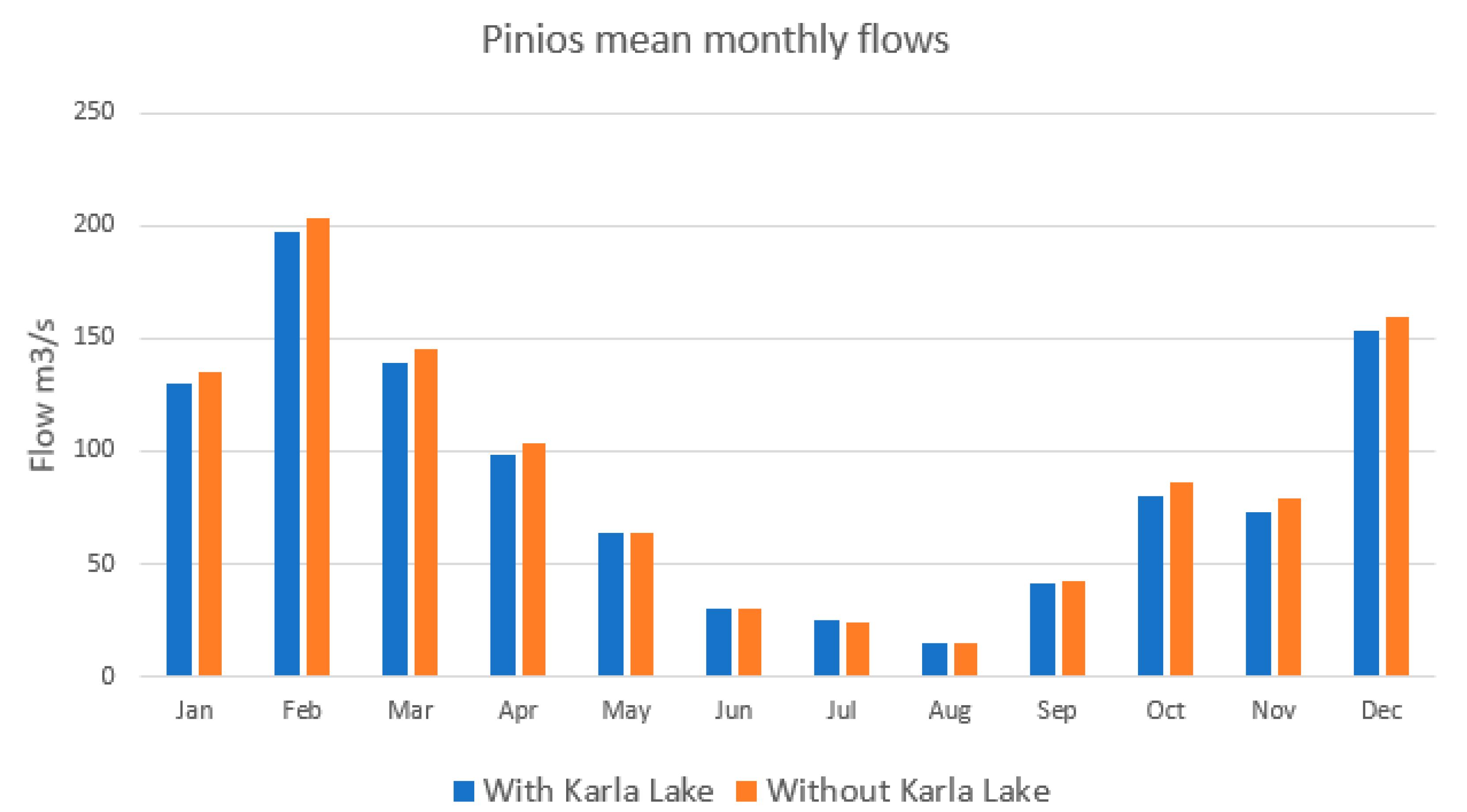
In the business-as-usual scenario with a full operating Lake Karla, the model simulates a mean annual flow of Pinios equal to 86.76 m3/s, almost 3.5 m3/s less than the simulated flow without the water transfers from Pinios to Lake Karla. Empirically, this flow reduction figure is rather low (less than 5% of the average annual reference flow) and, given the fact that the particular amount of water is abstracted during winter, the relevant hydrological impacts are not important. Figure 4 shows the mean monthly Pinios flows within the 10-y simulation period where the very small differences for the wet months are indicated. Those differences of the baseline Scenario A (with Lake Karla) from Scenario B (without Karla and water diversions from Pinios) are small, thus, their small magnitude does not have the capacity to attenuate possible floods along the downstream part of Pinios River. On the other hand, the river flows in summer remain unaltered between the two scenarios, as water transfers from Pinios to the lake take place only within the high-water availability period. The present result is a good indication that without any impact on Pinios River low flows during the dry period of the year, but also without important consequences on the high flows, a significant amount of water can be abstracted from Pinios during the high-flow winter period to give life to an ecosystem quite far, within Pinios basin, where the necessity for more water is high, especially during the dry period, to combat water scarcity and desertification.
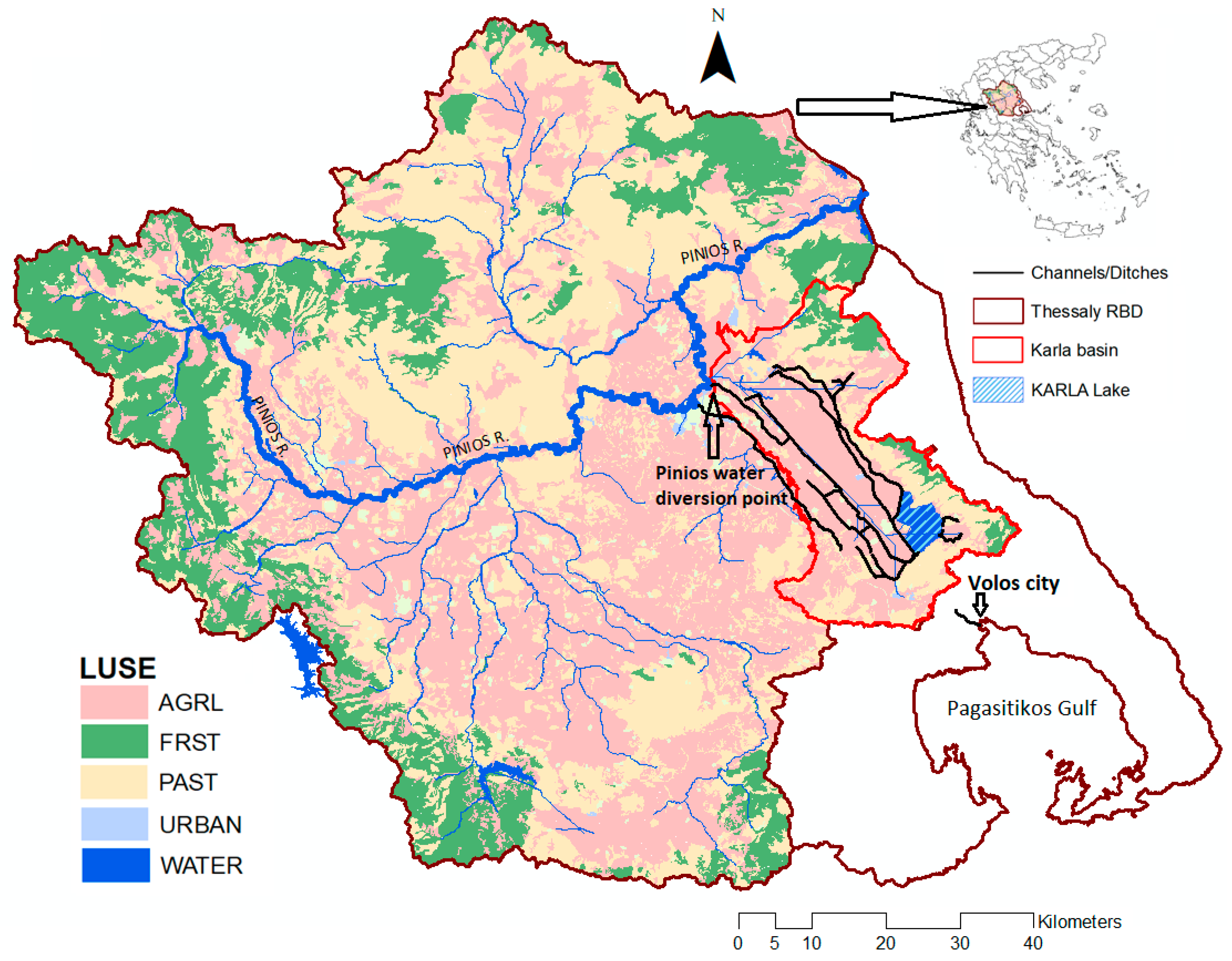
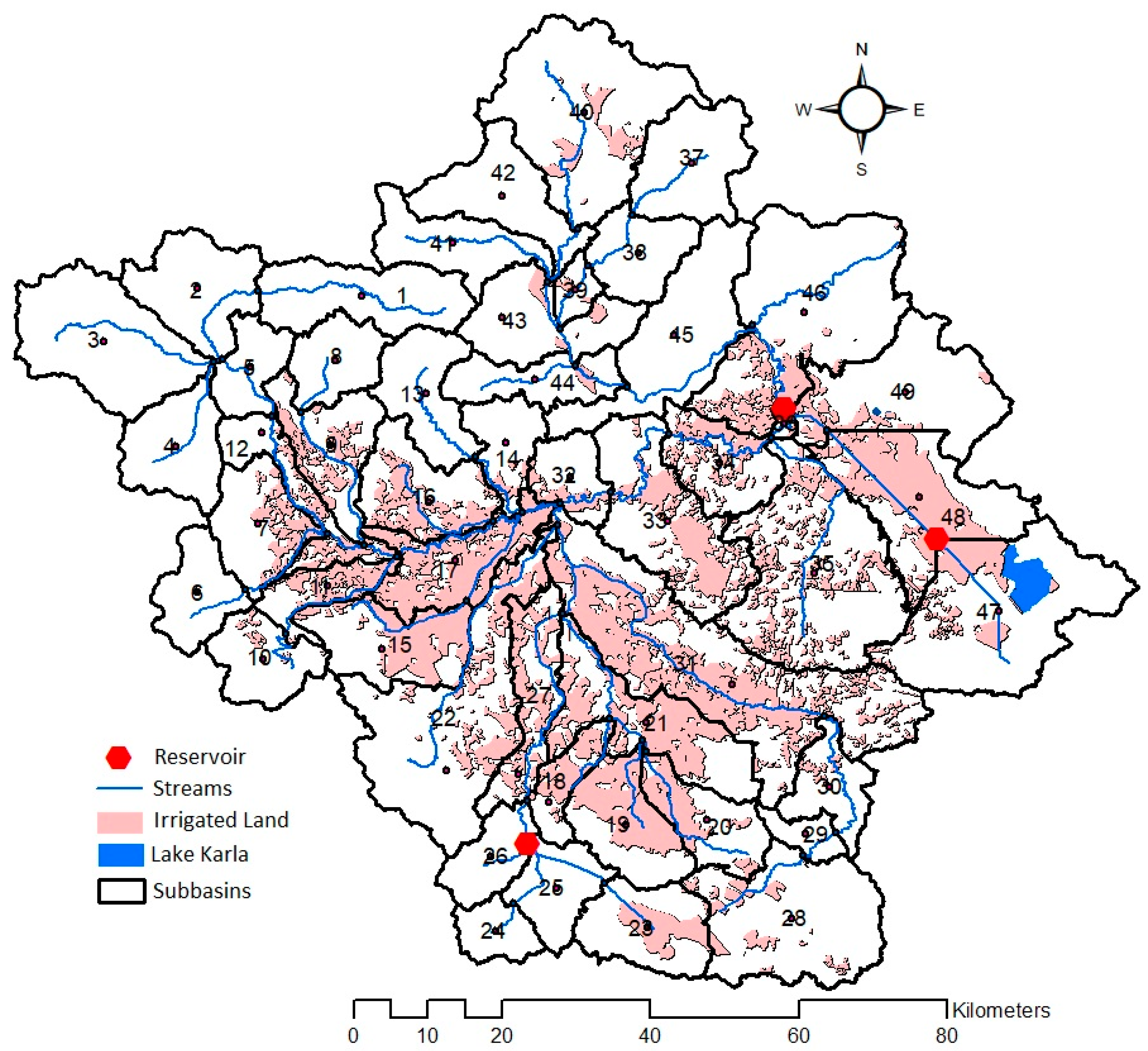
A more important result of the present modelling is related to the amount of irrigated water abstracted and applied in the cotton fields of subbasin 47 (see Figure 3) along with the cotton yield simulated. In Scenario B, the model was forced to apply 500 mm (5000 m3/ha) of water through 10 doses of 50 mm from May to September by abstracting water from groundwater. The availability of water, however, did not allow the doses to be covered entirely. Thus, only 215 mm (2150 m3/ha), less than 50% of the optimum, was finally abstracted and applied on a mean annual basis. On the other hand, with Lake Karla in the model (Scenario A), water was always available to apply to cotton fields and the optimum irrigation amounts of the 10 doses were completely satisfied. This resulted to an almost double mean annual cotton yield simulated as 4.89 t/ha for the 8000 of cotton land in subbasin 47 (Figure 3), which is reasonable after communications with local farmers who have deeply realized the response of cotton yield to the actual irrigation water amounts applied. The 2.2 t/ha difference compared to the no-Karla scenario, resulted from the crop-growth routine of SWAT which takes, among others, water stress days into consideration to accumulate crop biomass development on a daily basis [31]. As fertilization and climate did not differ between scenarios, changes in crop yields are solely attributed to irrigation water applied.
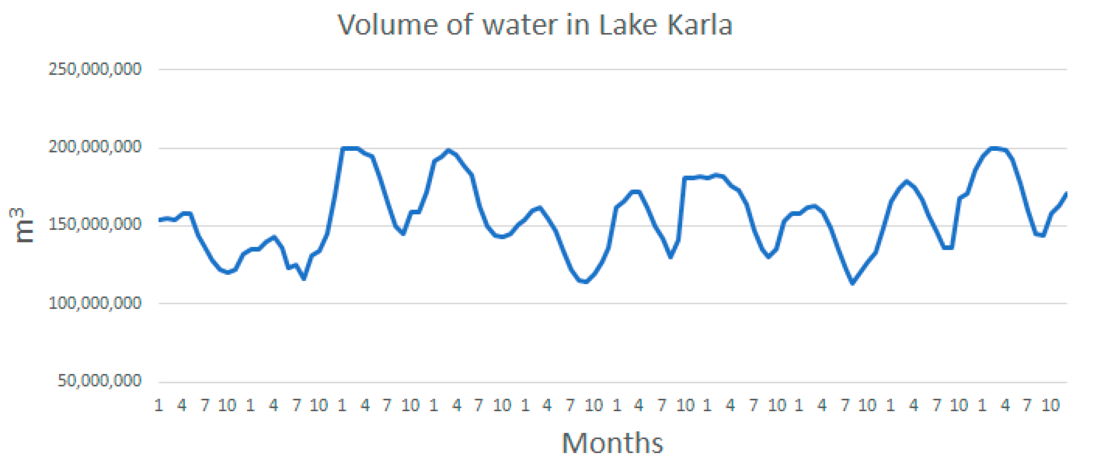
Another important model output is the water budget of Lake Karla within the simulation period, presented on a mean annual basis in Table 5. As already explained, a minimum water level of 2.5 m and 100 hm3 in the lake should always be maintained to support biodiversity. SWAT simulated monthly water storage as shown in Figure 5 for the 10-y simulation period. The graph reveals that our modelling respects the threshold of 2.5 m in the lake throughout the simulation period. During all months of the simulation, even the summer months when abstractions are maximized, the volume of water does not drop below the limit of 100 hm3. It is noted though, that in three months within the simulation period water volume reaches the maximum storage capacity of 200 hm3 resulting in water overflowing outside the basin. This water is lost from the system representing the removal of overflowing water to the sea in reality.

3.2. Effectiveness of the Nature-Based Solution

There are various ways to calculate the effectiveness of a measure, practice, or even big project like the NBS of Lake Karla. The effectiveness can express how much water is saved from the NBS or to what extent water can be used for an objective’s achievement. Here, we present some metrics of effectiveness resulted from the outputs that fit best to the study.
With Lake Karla the irrigation requirements are fully covered or the effectiveness of the NBS in meeting agricultural water needs is maximized (100%). Without the lake, only 215 mm out of the optimum 500 mm of water are used per year. The effectiveness of covering irrigation needs is only 43%. Therefore, the Lake Karla scenario increases water exploitation by 100/43 = 2.32 times or 132%. Total cotton production with Karla is double than without it; the 8000 ha irrigated and the respective productions are 39,120 t and 21,520 t per year. Therefore, the effectiveness of the NBS in increasing productivity is almost 100%.
Water saving in natural water bodies is very important as well. Lake Karla resulted in zero groundwater pumping for serving 8000 ha of land, which would be irrigated annually with 17.2 hm3 of groundwater otherwise (without Karla). This 17.2 hm3 is available for total abstraction of groundwater from the aquifer of subbasin 47 (see Figure 3), which, in SWAT, coincides with the area of the subbasin (area of subbasin 47 = ~480 km2). Therefore, for a land area of 480 km2 in subbasin 47 when Karla does not exist (Scenario B), SWAT simulates a net groundwater recharge rate of ~35 mm/y resulting in 17.2 hm3/y, abstracted entirely for irrigation. Without the 38 km2 Lake Karla in place the simulated net aquifer recharge from that fallow area of 38 km2 would be almost 38 km2 × 35 mm = 1.35 hm3. In Scenario A with Karla, seepage from the lake’s bottom is simulated at a rate of 0.1 mm/h (see Table 1), resulting to 33.2 hm3/y of aquifer recharge from the 38 km2 area, almost 30 hm3/y more. In total, it can be estimated that, around the Karla plain, groundwater replenishment is extremely important as the aquifer gains tens of hm3 per year. According to the estimations herein, gains approach 50 hm3/y, which arise both from the substantially increased percolation of water and the zero groundwater abstractions.
A final metric of effectiveness is the extent to which the Lake Karla project can reduce Pinios high flows. In our model there is a stable abstraction of 5 m3/s (430,000 m3/d) from Pinios for diversion to Lake Karla from October to April. For the high winter monthly flows of the river (80 < Q < 200 m3/s) such a subtraction of water results to a less than 5% flow reduction. Therefore, with the present pumping stations along Pinios that divert water through the transport ditches to Karla, the effectiveness of the NBS to reduce high river flows and the potential flood risk along Pinios River can be considered low. Nevertheless, since the water routing capacity of the transport ditches is quite high, one could think of using the system also for flood mitigation in the Pinios River itself with the purpose to reduce the flood inundation risk for parts of the agricultural plain downstream. This would require more dedicated hydraulic works at the point of water withdrawal from the Pinios River towards Lake Karla.
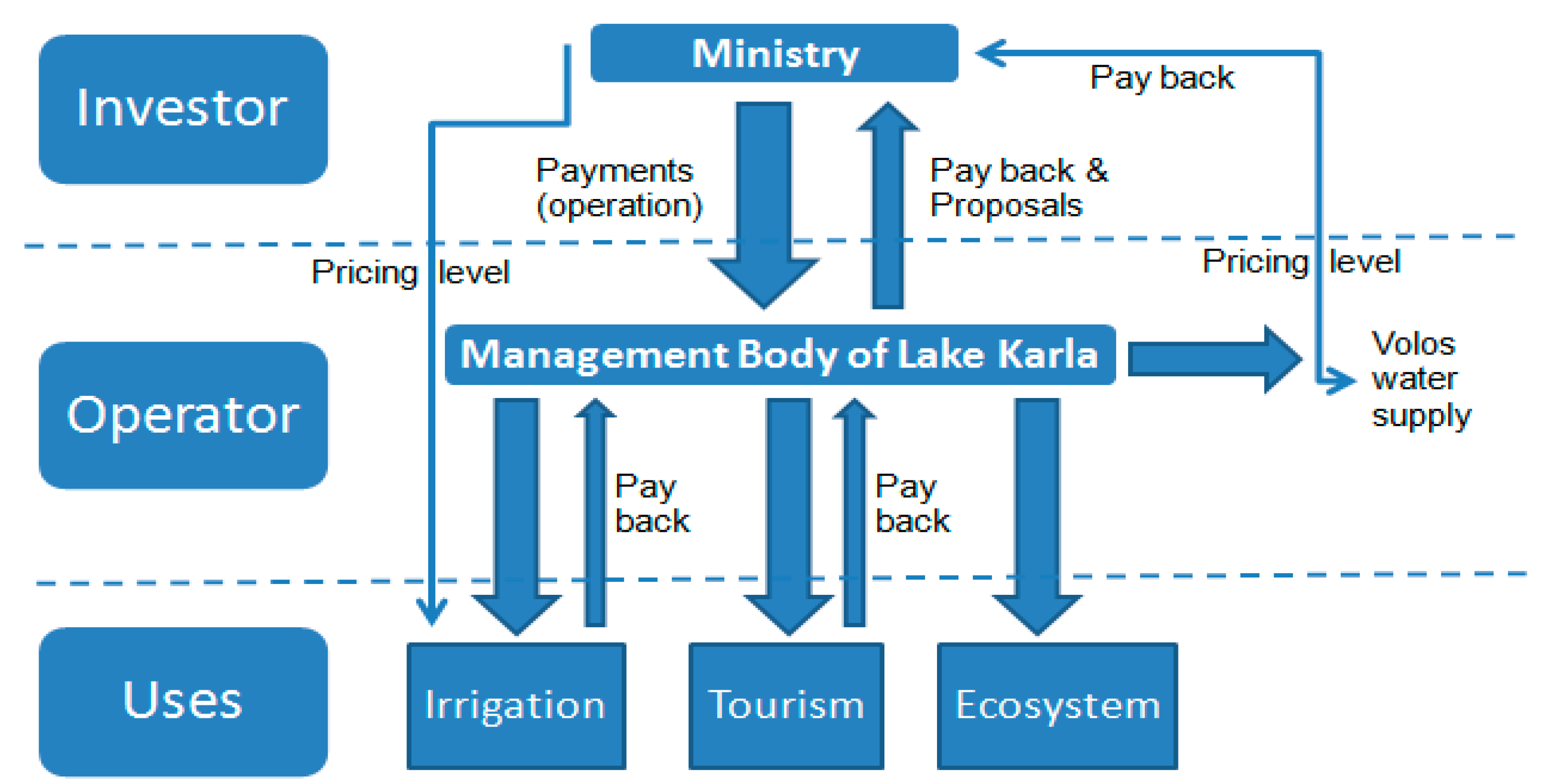
3.3. Cost Recovery

According to the WFD, an economic analysis of water uses includes: (a) Estimation of the current financial, environmental, and resource cost of water; (b) calculation of the cost recovery; and (c) discussion of flexible pricing policies that offer incentives for efficient use of water resources and for the achievement of the environmental objectives of the Directive. The categories of costs to be considered are: (a) Financial cost, including operational and maintenance costs, capital costs, administrative costs; (b) resource costs, defined as opportunity costs for the alternative uses of water; (c) environmental cost, defined as economic cost due to the environmental damage caused. The financial cost is usually the largest type of cost, which can be directly estimated. On the other hand, the estimation of the resource and environmental costs is more difficult as one has to consider and quantify the foregone benefits and environmental damage caused, respectively. Studies relevant to the Pinios River basin, dealing with the estimation of the full cost of irrigation water, have shown that both the last two types of cost can be quite important, especially in water scarce areas with high irrigation needs such as Pinios basin [38,39].
However, within the context of constructing the Lake Karla NBS in this work, the resource cost can be considered negligible as natural runoff waters from Lake Karla’s surrounding areas and diversion water from Pinios to Karla would not be used otherwise. In fact, Pinios flows of the wet months of the year would be only slightly higher along the most downstream part of the river. The transfer of river water due to the diversion cannot be considered an adverse effect and cannot cause a remarkable resource cost, since river water was naturally overflowing towards the original Karla lake in the past when reference hydrologic conditions in the basin dominated. On the other hand, significant groundwater resources are saved and can theoretically be used for other purposes or in other adjacent areas. In this case, additional crop areas from those irrigated with water from Lake Karla could be served by the water saved in the aquifer resulting in crop yield increase and additional income. Although this benefit is important, saved groundwater is not exploited for other purposes in this study because of technical and economic issues (e.g., additional constructions are required to transfer water to longer distances) that require a detailed focused study to be performed. Therefore, it is beyond the scope of this study to suggest where saved groundwater can be used in the future and calculate the economic benefit from this action. Finally, there is negligible environmental cost from the construction of Lake Karla since it is a restoration project to re-establish part of the original lake that has significant environmental benefits while increasing the local aquifer’s water availability.
As calculated above, the annual cost recovery of the Lake Karla project should be around €15,000,000 per year for a 50-y lifetime period. This, in practice, means that by operating the project the benefits should be high enough to allow an annual return of €15,000,000 to the investor. In our case the investor is not a private company but the EU and the Greek State. Usually, the EU cost is not expected to be recovered entirely (with direct returns) but the investment seeks to assist the communities in improving their way of living, resulting in economic gains in the long-term. By increasing society’s prosperity, there are always future indirect returns. With reference to the agricultural sector, in this study we have two obvious types of economic benefits from the use of irrigation water from the Lake Karla project. One is the return cost to the investor that can be assumed as direct recovery cost and the other is the farmers’ individual economic benefits arising from a crop yield increase.
The potential for cost recovery is assessed through: (a) A volumetric pricing method for irrigation water, (b) an urban water supply fee, and (c) a recreation fee. The first two comprise the major twofold use of water stored in Karla and are of similar economic relevance: The 10 hm3 of urban water supply are given at a much higher price than the 40 hm3 given to agriculture (see next). A fee for fishermen in Lake Karla is not included in the potential sources of return cost because it remains unclear what the capabilities of the lake are in providing fish for commercial purposes, even for supporting recreational fisheries, while at least the first years of the lake’s operation it is suggested not to promote any fishing permits given the priority to enhance biodiversity through the rehabilitation of the ecosystem.
To pay back the large investment (and operational/maintenance) cost a water consumption cost (€/m3) for the farmers is proposed. Currently, only for the irrigated areas that are irrigated by public boreholes, there is a management fee, which is based on the typical for Greece, cheap but inefficient, area pricing method [40,41]. But even in this case, the high energy cost of operating the boreholes is shared between farmers. On the other hand, the majority of farmers have their private boreholes and the frequency of their operation is based on empirical criteria according to the irrigation needs. Therefore, for all farmers around Karla, who either use their private boreholes or public ones, the total irrigation cost is in practice fully covered by them. By substituting groundwater pumping with Lake Karla’s water, the energy cost for the farmers will be zeroed; however, for the viability of the project, a pricing policy should be adopted. At the same time, such a policy is considered necessary for avoiding waste of water and ensuring environmental sustainability.
The specific reactions of farmers to a volumetric water pricing policy are quite difficult to predict, with studies in the Greek territory having shown contradictory results regarding the level of water pricing up to which demand will remain inelastic [40,41,42,43]. In the literature, there are proposed prices between 0.01 and 0.10 €/m3. Pricing is included in the present analysis with the upper bound of this range, a fixed value of 0.10 €/m3 of irrigation water used, which results to be the same cost currently borne by the farmers with irrigation coming from groundwater (shown next).
On the other hand, the water supply fee in towns and cities of the Thessaly region varies according to the consumption level and ranges between 0.5 and 2 €/m3 [24]. For the purposes of this study, 1.2 €/m3 is realistic concerning the Karla’s water use for domestic purposes in the city of Volos. Assuming that half of this cost has to be retained by the water supply company of the Municipality of Volos to support water treatment of the raw water from Karla and its distribution to users, the remaining 50% can be driven to the investor, thus contributing 0.6 €/m3 to the direct cost recovery of the Lake Karla project. It should be mentioned here that keeping half of the revenue for covering the treatment and distribution costs is supposed to be enough for the Volos water supply company given that the infrastructure within the urban water cycle already exists. Moreover, as water transport from Karla to Volos is part of the Lake Karla project, its cost has been incorporated in the OMC of Equation (1) and Table 3. The total annual water demand for Volos city from Lake Karla has been estimated as 10,000,000 m3, which, based on proper demand control measures (pricing of water) in parallel with raising awareness of people on water efficiency, could cover the needs of >160,000 inhabitants (including visitors) in the Volos metropolitan area [24].
Finally, tourism is currently insufficiently developed and any efforts to quantify return cost from this source are rather uncertain. However, there are already great tourism opportunities both in the Prefecture of Magnesia and its capital city of Volos, such as museums, archaeological sites, train routes, hiking, biking, etc. [44], with increasing numbers of visitors in the last few years. The tourism expectations for the area around Karla can also be high, under an effective promotion plan of the attractiveness of Karla’s environment including, among others, unique birdwatching opportunities in the southern Balkan peninsula, as well as visits to a contemporary museum and culture exhibition center. For the needs of this study we assume that 20,000 visitors can be attracted per year, paying a minimum of €50 for all services around the lake, such as hiking, biking, bird watching, visiting the exhibition center, etc. Table 6 summarizes the annual return cost offered by the above three sources.
The indirect cost (or benefit) for the farmers from the use of irrigation water from Lake Karla is considerable with the calculations being summarized in Table 7. The table includes the additional economic benefit arising for the farmer assuming that, except the source and available quantity of irrigation water, all other agricultural practices such as soil ploughing, fertilization, chemicals application, irrigation application to the field, as well as the use of machinery and labor to perform those practices remain the same.
The substitution of groundwater with surface waters in the irrigated area of the 8000 ha around Lake Karla results in an irrigation cost of 4,000,000 €/y for the farmers (based on the volumetric pricing of 0.10 €/m3), which is identical with the cost of operating their boreholes to pump groundwater (500 €/ha * 8000ha = 4,000,000 €). This does not result to a direct economic benefit for the farmers who would expect spending less money than they were spending before to cover the irrigation needs of their crop areas. Although an equal cost does not seem attractive for them, reliable availability of good quality water for irrigation can settle down their concerns, while pricing is considered necessary towards the target of cost recovery. However, an important benefit for the farmers is the increased crop yields. Based on the present estimations of the SWAT crop growth routine, the mean annual cotton yield will increase by 2.2 t/ha due to the Lake Karla project operation (see Table 4), which is capable to provide them with the optimum irrigation amount of 500 mm (5000 m3/ha) per growing season. The additional income is here calculated as 880 €/ha or 7,040,000 € for the whole area based on a 0.40 €/kg price of cotton, selected as the guaranteed lower bound of the price range over the years.
So, from the additional crop production, there is a benefit of 7 M€/y for the farmers of the study area around the new Lake Karla. If this amount could be directly added to the total return cost of 11 M€/y calculated on Table 6, it would result to 18,000,000 €/y which ensures a full recovery of the project’s annual equivalent cost according to the majority of OMC and interest rate combinations of Table 3. Meeting the recovery target by calculating the benefits that can be monetized, shows that, at no extra cost, the project can secure the restoration of an important ecosystem such as Lake Karla, reduce water stress in the Karla basin’s groundwater resources and in those presently supplying Volos, as well as emerge the touristic sector that was undeveloped before in the area. The value of all benefits, even the non-monetized environmental ones, seems high, showing that the NBS project of Lake Karla allows good business while protecting the environment.

4. Discussion

4.1. Realizing all Benefits

From the analysis in this study, it is shown that the newly constructed Lake Karla can support various types of benefits (some quantifiable in monetary terms and others not), ensuring their delivery to society with a high degree of certainty even under unfavorable climate conditions, which without the Karla project could largely affect drought severity in the area [45]. The analysis is based on a modelling study for the representation of the water budget of the lake, water transfers, and crop productivity, including 10 years of simulation, with some relatively dry years among them. The greatest advantage of the Lake Karla reconstruction project is that its water availability relies mainly on Pinios water diversions during the wet period of the year with low quantities that are always guaranteed without adding hydrologic pressures to the river. To summarize all benefits arising from the operation of the Lake Karla project we associate them with ecosystem services in Table 8 (based on Grizzetti et al. [46]).
People will obtain several kinds of benefits through ecosystem services from the restored Lake Karla. In terms of provisioning services, the major benefit is water allocation at adequate quantities for drinking purposes in Volos city, as well as for irrigation. Regarding the first, Lake Karla will ensure the availability of water at the appropriate quantities even during dry years when the conventional water supply methods from groundwater pumping around the city would be uncertain. As far as agriculture is concerned, high water quantities for irrigation are directly translated to crop productivity and income for the farmers. The specific economic benefits for the agricultural sector have been analyzed before and are valuable. An almost double production of cotton is estimated as a response to the almost double water availability. The farmer community in the area can gain almost 7,000,000 €/y or 880 €/ha/y. The average farmer around Lake Karla with a typical property of 4–5 ha of agricultural land and an individual annual income of 15–20 K€ [16,17] will thus increase his annual income by ~4000 € or 20–25%. On top of that, every farmer will get rid of the anxiety and uncertainty of finding adequate water and of suitable quality for irrigation (e.g., no salty water) to meet the necessary annual production and income, a situation with both direct (economic) and indirect (emotional) benefits, which will lead to the increase of life quality. It should be noted here that by not keeping irrigation water costs at low levels, namely lower than the respective costs without Lake Karla, farmers may not be directly satisfied, but high added-value agriculture can be stimulated. Farmers will continue paying the same amount of money at an annual basis for obtaining irrigation water but for more than double water quantities, with simultaneous minimization of water losses. By increasing water productivity (production per unit volume of water consumed), agriculture becomes more economically beneficial, enhancing at the same time the level of environmental sustainability in the area.
The wider agricultural floodplain around Karla will be highly protected from inundation, even during a very wet season with extreme precipitation. Flooded waters will be trapped in the Karla reservoir through the constructed works already in place. A farmer will not become desperate when a meteorological extreme occurs, resulting in excess surface water. Moreover, by saving millions of m3 of water in the wider aquifer around Karla, groundwater rehabilitation will be achieved and desertification will be mitigated. Increased availability of groundwater will increase water in the nearby intermittent and ephemeral streams and may also allow pumping outside the perimeter of the area irrigated from Karla, either for irrigation of additional crop areas that were not irrigated before or for satisfying other water uses, which are beyond the scope of this study to propose and quantify.
The very positive situation above will be the precondition ensuring the maintenance of the agricultural population in the region. The perspective of a stable business opportunity including agriculture and tourism/services related to the lake environment can even motivate a population return to the countryside from the cities that have suffered more during the last years from the economic crisis and austerity. All the above can result in a reduction of unemployment and welfare increase, transmitting a feeling of optimism to the new generations.
The ecological benefits including biodiversity enhancement inside and around the lake are also important and can give rise to tourism opportunities. The lake is already a hot spot of biodiversity offering food and shelter for many species of migratory birds, hundreds of which have already been spotted at Lake Karla since its restoration. Many lowland bird species favor nesting in the marshes of the lake as well as in the artificial islands. The international significance of Lake Karla is supported by its designation as a Natura 2000 site (GR1430007) mainly due to the presence of numerous birds, including squacco heron (Ardeola ralloides), purple heron (Ardea purpurea), short-toed lark (Calandrella brachydactyla), black tern (Chlidonias niger), black-winged stilt (Himantopus himantopus), and little bittern (Ixobrychus minutus) [20].
The fish community of Lake Karla is already composed of six families and thirteen species. The family of Cyprinidae is the most dominant both in terms of abundance and biomass, while the common carp (Cyprinus carpio) accounts for 3.98% in terms of abundance and 8.68% in biomass of the Cyprinidae family. There are endemic fish, i.e., Cobitis vardarencis and Cobitis stephanidisi, with the last one being exclusively endemic for Lake Karla. The species Alosa fallax uses the Karla site for breeding and nesting while the Cobitidae species are considered as permanent [13].
Finally, Lake Karla and its surrounding areas can offer great cultural services. The environment is ideal for recreation and environmental awareness activities. The area already includes info-kiosks and observation posts (e.g., bird watching), a tourist information center, and a natural history and folklore museum along with parking and camping areas [47]. It can offer activities such as tree planting along the perimeter and the embankments of the lake, visiting environmental education sites, as well as horse riding, cycling, and hiking routes, which could be followed in a second phase by water sports facilities and accommodation services. Recent Greek studies that deal with the willingness to pay principle, encourage the development of those activities in Lake Karla. A study from the Prefecture of Pella in Northern Greece, which was based on a face-to-face questionnaire surveyed among 323 visitors of thermal springs, indicated that alternatives such as the development of an educational center and ecotourism leisure activities including hiking and water sports in Lake Vegoritida were very attractive for almost half of the people questioned [48]. Another study, which aimed to investigate visitors’ perceptions of an important nesting ground for sea turtles located in the touristic area of Rethymno, Crete, showed positive attitude towards the establishment of two policy instruments to secure funding for the improvement of the environmental management of the area: An entrance fee to the beach and a tax to be levied on local accommodation costs [49]. Both of them are considered applicable to the case of Lake Karla.

4.2. Management and Governance

The re-establishment of Lake Karla was a big and expensive project, which needs a governance and management plan to operate efficiently in the long-term. In this regard, the active involvement of key actors/stakeholders is an effective means of connecting technical and social-governance issues. Their engagement makes it possible to solve more effectively complex planning challenges through a collaborative approach. A set of roles and responsibilities is required to guide the operation of the Lake Karla project.
A proposed governance scheme of the NBS begins from the investor/decision maker and includes two other main levels—the operator(s) and the users. The EU and the Greek State form the investor in this study, who paid for the construction of the project and are responsible for its maintenance through a viable economic scheme based on cost returns. The regulator and high-level supervisor are represented by the Special Secretariat for Water of the Ministry of Environment and Energy and its local branch in the region, the Regional Water Authority of Thessaly. This multi-faceted organism will be called “the Ministry” from now on representing the investor who sets the rules (defining volumetric prices). The Ministry has to be in cooperation with the local management authority of the NBS, the established Management Body of Lake Karla. The Body applies the rules, having many responsibilities related to the operation of the NBS including the continuous implementation of the monitoring and environmental protection programs of the lake. In the administrative board of this body, representatives from local municipalities, the Ministry, the farmers union, the regional public authority, and environmental NGOs participate. Figure 6 presents this governance structure schematically, which is analyzed next.
The Ministry is responsible to finance the project both with regard to the construction cost (completed in combination with EU funding), and the annual operation cost. Thus, the Ministry will pay regularly for the purchase of new equipment and consumables, and will cover the cost of power consumption and the payments of the staff of the Management Body. The Body should employ administrative and scientific personnel, irrigation water distributors to control irrigation water use across the farm fields, engineers/technicians to maintain the working parts and equipment of the reservoir, and guards. In total, this cost has been assumed in Table 3 to range within 1–3% of the total construction cost, being 2.5–7.5 M€/y (see Section 2.2 and Equation (1)). With just a small part of this amount being spent for salaries, the personnel could be comprised of at least 50 people, adequate to support the operation of the big project. The Ministry will also directly collect the return payments from the water supply company of Volos (50% of water supply fees) and will regulate the volumetric water pricing both for urban water supply and irrigation use.
Of significant importance is the need to raise awareness among all of the users/stakeholders for the efficient and effective operation of the system. To this end, the Ministry should ensure representativity of key stakeholders in the Management Body of Lake Karla in order to guarantee a participatory and inclusive governance. People’s needs have to be communicated to the investor facilitating the dynamic update of decision-making towards a socially acceptable management of the NBS. As operator, the Management Body of Lake Karla will have a key role in the management of the whole project. It has to coordinate the payment of fees and levies from the farmers and tourists on behalf of the Ministry. For the volumetric pricing in agriculture, the Management Body should be in cooperation with the farmers, both the local farmers’ union (Karla’s LOLR) and individual farmers. The LOLR had the legal responsibility to manage irrigation water within the irrigation water district of Karla from the public boreholes before Lake Karla’s recreation. Similar to its prior responsibility, it should have a role in the irrigation district under the new regime. It is thus suggested the integration of the LOLR into the Management Body (operator) through the involvement of its most experienced members (farmers) in the Body’s board. It is believed that the full integration of the LOLR will ensure that the new operator will have deep knowledge of the current agricultural issues and needs.
For example, the volumetric pricing of irrigation water might cause potential negative reactions as certain farmers or groups of farmers may not understand the actual economic benefits they will have from the project in terms of crop productivity. A Management Body with experienced farmer representatives will facilitate the wider understanding, even from the most skeptical farmers, that despite the no cheaper volumetric pricing, they should remain patient for a maximum of a couple of crop growth seasons to note the significant productivity (and personal income) increase due to the operation of the project. The agricultural pricing policy should be strictly maintained with two conditions respected: (a) Cost should be recovered to a satisfactory level, and (b) the new pricing policies should not create or exacerbate conditions of water poverty in low income households. Although the latter is not expected for any farmer, it is considered necessary that exemptions are recognized on the basis of social criteria and the level of pricing is updated accordingly. For example, instead of fixed pricing, a tiered pricing system can be proposed to the Ministry with the purpose to overcome potential socio-economic heterogeneities, shifting portions of the required return cost from the less to the more prosperous farmers. A minimum 0.10 €/m3 of volumetric pricing should always be ensured on average; however, in years of high productivity and income, pricing can even increase for all farmers to better meet the project’s cost recovery target.
The Management Body will be also responsible for the ecosystem management and recreation and environmental awareness activities. It will operate the tourist information center, the museum, it will organize environmental education and sport activities, and will collect the respective fees, to be added to the return costs to the investor. Regarding the ecosystem management, the Management Body has to ensure that the NBS acts as a wetland so the minimum water depth and the ecosystem functioning are maintained. Ecologists and environmental scientists from the Management Body, in cooperation with local environmental/ecological organizations, have to ensure that the lake acts as an important reservoir for biodiversity and healthy ecosystem, maintaining its fish and bird species.
Despite the fact that all stakeholders are considered as supporters of the NBS, a strong alliance among them has to be established. The Management Body should cover the potential lack of knowledge on the strong multi-purpose, beneficial nature of the project and the very low risk of not meeting all its targets when operating according to specific rules. Indeed, the analysis and results of the present study prove that around the newly constructed Lake Karla, urban water supply is guaranteed, irrigation requirements are satisfied, and the lake’s ecosystem is enhanced. Apart from covering the investment cost in a 50-y horizon, the operation of the project will provide the majority of stakeholders (farmers and tourism industry) with additional direct income.
Among the potential bottlenecks and implementation problems of the Lake Karla project are the incompletion of secondary works around the reservoir, such as a small part of the initially planned irrigation network, as well as the delay in starting the transportation of water to Volos for urban use. Moreover, a constructed wetland on the western side of Lake Karla for lowering nutrient load of water diverted from Pinios and the artificial islands for bird nesting within the lake are not functioning at their optimum levels, while specific tourism investments such as viewpoints and information spots have been vandalized in the past. In this work, the benefits, costs, and cost recovery were estimated with reference to a full operating project that is expected after small interventions are finalized, any small malfunctions are restored, and final decisions are taken related to the responsibilities and operation of the Management Body of Lake Karla. With the lake and its subprojects being now entirely visible, the wider acceptability of the project and the active role of the Management Body in strengthening it will ensure the formation of a stable “community” with negligible behavioral problems, aligned interests, and shared responsibility towards the viability of the project in the long-term. Experts and guards under full-time employment will also ensure the maintenance and protection of the project at a stable basis.
Therefore, despite any existing limitations or pending issues, the main outputs of the present study depicting the advantages of the particular nature-based solution (reconstructed Lake Karla project in Central Greece) can be considered applicable and valid for other similar cases, not only around the Mediterranean region but also in other areas where agriculture suffers from dry conditions and inefficient management of water resources. The only prerequisites for the above are the appropriate design of the project and the need for effective, efficient, and cooperative water management along with managing smaller administrative and behavioral issues. A cost recovery approach such as this presented in this article, followed by an updated economic analysis if required, can be the basis for setting up an official management scheme of the Lake Karla project, encouraging beneficial investments for both agriculture and the environment.

Author Contributions

Conceptualization, Y.P. and E.D.; methodology, Y.P. and E.D.; software, Y.P.; validation, Y.P.; formal analysis, Y.P. and E.D.; investigation, Y.P. and E.D.; resources, Y.P. and E.D.; data curation, Y.P.; writing—original draft preparation, Y.P.; writing—review and editing, Y.P. and E.D.; visualization, Y.P. and E.D.; supervision, Y.P. and E.D.; project administration, Y.P. and E.D.; funding acquisition, Y.P. and E.D. All authors have read and agreed to the published version of the manuscript.

Funding

This research received funding from the EU Joint Research Center (JRC) under the contract: JRC-IRP No.937804: Lot 9 Landscape elements for water retention (LWR) in a Mediterranean environment.

Acknowledgments

The authors should thank the JRC scientist Alberto Pistocchi for his comments and suggestions which substantially improved this manuscript, as well as for his advice, support, and fruitful discussions. Moreover, the authors should thank Ifigenia Kagalou, Pantelis Sidiropoulos and Ioannis Vergos from the Management Authority of Lake Karla for the valuable guided tour around the lake in October 2019, as well as Maria Chamoglou from HCMR for her suggestions and support.

Conflicts of Interest

The authors declare no conflict of interest.

References

  1. European Parliament & Council. Directive 2000/60/EC of the European Parliament and of the council of 23 October 2000 Establishing a framework for community action in the field of water policy. Off. J. Eur. Communities 2000, 327, 1–73. [Google Scholar]
  2. Wriedt, G.; Van der Velde, M.; Aloe, A.; Bouraoui, F. Estimating irrigation water requirements in Europe. J. Hydrol. 2009, 373, 527–544. [Google Scholar] [CrossRef]
  3. EEA. Towards Efficient Use of Water Resources in Europe; Report No 1/2012; EEA: Copenhagen, Denmark, 2012; ISSN 1725–9177. ISBN 978-92-9213-275-0. Available online: http://www.eea.europa.eu/publications/towards-efficient-use-of-water (accessed on 18 August 2020). [CrossRef]
  4. EEA. Use of Freshwater Resources in Europe; Report No 1/2012; EEA: Copenhagen, Denmark, 2019; ISSN 1725–9177. [Google Scholar]
  5. Sonneveld, B.G.J.S.; Merbis, M.D.; Alfarra, A.; Ünver, O.; Felicia Arnal, M. Nature-Based Solutions for Agricultural Water Management and Food Security; FAO Land and Water Discussion Papers; FAO: Rome, Italy, 2018. [Google Scholar]
  6. EC. Nature Based Solutions. Available online: https://ec.europa.eu/research/environment/index.cfm?pg=nbs (accessed on 18 August 2020).
  7. Loukas, A.; Vasiliades, L. Probabilistic analysis of drought spatiotemporal characteristics in Thessaly region, Greece. Nat. Hazards Earth Syst. Sci. 2004, 4, 719–731. [Google Scholar] [CrossRef]
  8. Panagopoulos, Y.; Makropoulos, C.; Kossida, M.; Mimikou, M. Optimal implementation of irrigation practices: Cost-effective desertification action plan for the Pinios basin. J. Water Resour. Plan. Manag. 2013, 140, 1943–5452. [Google Scholar] [CrossRef]
  9. Panagopoulos, Y.; Makropoulos, C.; Gkiokas, A.; Kossida, M.; Evangelou, L.; Lourmas, G.; Michas, S.; Tsadilas, C.; Papageorgiou, S.; Perleros, V.; et al. Assessing the cost-effectiveness of irrigation water management practices in water stressed agricultural catchments: The case of Pinios. Agric. Water Manag. 2014, 139, 31–42. [Google Scholar] [CrossRef]
  10. Vasiliades, L.; Loukas, A.; Liberis, N. A Water Balance Derived Drought Index for Pinios River Basin, Greece. Water Resour. Manag. 2011, 25, 1087–1101. [Google Scholar] [CrossRef]
  11. Zalidis, G.; Takavakoglou, V.; Panoras, A.; Bilas, G.; Katsavouni, S. Reestablishing a sustainable wetland at former Lake Karla, Greece, using Ramsar restoration guidelines. Environ. Manag. 2004, 34, 875–876. [Google Scholar] [CrossRef]
  12. Recreation of Lake Karla. Available online: http://www.limnikarla.gr/en/ (accessed on 18 April 2020).
  13. Sidiropoulos, P.; Chamoglou, M.; Kagalou, I. Combining conflicting, economic, and environmental pressures: Evaluation of the restored Lake Karla (Thessaly-Greece). Ecohydrol. Hydrobiol. 2017, 17, 177–189. [Google Scholar] [CrossRef]
  14. Sidiropoulos, P.; Papadimitriou, T.; Stabouli, Z.; Loukas, A.; Mylopoulos, N.; Kagalou, I. Past, Present and Future Concepts for Conservation of The Re-Constructed Lake Karla (Thessaly-Greece). Fresenius Environ. Bull. 2012, 21, 3027–3034. [Google Scholar]
  15. Mouratiadou, I.; Moran, D. Mapping public participation in the Water Framework Directive: A case study of the Pinios River Basin, Greece. Ecol. Econ. 2007, 62, 66–76. [Google Scholar] [CrossRef]
  16. Bakopoulou, S.; Kungolos, A. Investigation of wastewater reuse potential in Thessaly region, Greece. Desalination 2009, 248, 1029–1038. [Google Scholar] [CrossRef]
  17. Stamou, M. Assessment of the environmental cost of the delayed reconstruction of Lake Karla. Master’s Thesis, University of Thessaly, Volos, Greece, 2015. (In Greek). [Google Scholar]
  18. Jerrentrup, H. The fauna of the former Lake Karla. In Conservation and Management of the Greek Wetlands; Gerakis, P., Ed.; IUCN and Aristotle University: Thessaloniki, Greece, 1990; pp. 527–535. [Google Scholar]
  19. Ananiadis, C.I. Limnological study of Lake Karla. Bull. Inst. Oceanogr. 1956, 1083, 1–19. [Google Scholar]
  20. Dodouras, S.; Lyratzaki, I.; Papayannis, T. Lake Karla Walking Guide; Mediterranean Institute for Nature and Anthropos (med-INA): Athens, Greece, 2014; 228p. [Google Scholar]
  21. Gerakis, P.A. Former Lake Karla Rehabilitation Case Study, Conservation and Management of Greek Wetlands; IUCN: Gland, Switzerland, 1992; pp. 429–489. [Google Scholar]
  22. Loukas, A.; Mylopoulos, N.; Vasiliades, L. A modelling system for the evaluation of water resources management strategies in Thessaly. Water Resour. Manag. 2007, 21, 1673–1702. [Google Scholar] [CrossRef]
  23. Zalidis, G.C.; Katsavouni, S.; Bilas, G.; Chatzigiannakis, S. Suggested Interventions to Restore Sustainably the Karla Wetland; Greek Biotope/Wetland Centre: Thessaloniki, Greece, 1999. (In Greek) [Google Scholar]
  24. Ministry of Environment Energy and Climate Change. Special Secretariat for Water Management Plan of the River Basins of Thessalia River Basin District (Gr08) Phase, C; Government Gazette approving the RBMP: Athens, Greece, 2014. Available online: http://wfdver.ypeka.gr/el/management-plans-gr/approved-management-plans-gr/gr08-approved-gr/ (accessed on 22 January 2020).
  25. Arnold, J.G.; Srinivasan, R.; Muttiah, R.S.; Williams, J.R. Large area hydrologic modelling and assessment part I: Model development. J. Am. Water Resour. Assoc. 1998, 34, 73–89. [Google Scholar] [CrossRef]
  26. Williams, J.R.; Arnold, J.G.; Kiniry, J.R.; Gassman, P.W.; Green, C.H. History of model development at Temple, Texas. Hydrol. Sci. J. 2008, 53, 948–960. [Google Scholar] [CrossRef] [Green Version]
  27. Gassman, P.W.; Reyes, M.R.; Green, C.H.; Arnold, J.G. The Soil and Water Assessment Tool: Historical Development, Applications, and Future Research Directions. Trans. ASABE 2007, 50, 1211–1250. [Google Scholar] [CrossRef] [Green Version]
  28. Gassman, P.W.; Sadeghi, A.M.; Srinivasan, R. Applications of the SWAT Model Special Section: Overview and Insights. J. Environ. Qual. 2014, 43, 1–8. [Google Scholar] [CrossRef]
  29. Tuppad, P.; Douglas-Mankin, K.R.; Lee, T.; Srinivasan, R.; Arnold, J.G. Soil and Water Assessment Tool (SWAT) hydrologic/water quality model: Extended capability and wider adoption. Trans. ASABE 2011, 54, 1677–1684. [Google Scholar] [CrossRef]
  30. SWAT. ArcSWAT: ArcGIS-ArcView Extension and Interface for SWAT U.S.; Department of Agriculture, Agricultural Research Service, Grassland, Soil & Water Research Laboratory: Temple, TX, USA, 2018; Available online: http://swat.tamu.edu/software/arcswat/ (accessed on 18 August 2020).
  31. Neitsch, S.L.; Arnold, J.G.; Kiniry, J.R.; Williams, J.R. Soil and Water Assessment Tool—Theoretical Documentation Version 2009; Texas Water Resources Institute Technical Report 406; Texas A&M University System College Station: Blackland, TX, USA, 2011; Available online: http://swat.tamu.edu/media/99192/swat2009-theory.pdf (accessed on 18 September 2018).
  32. EEA-ETC/TE. CORINE Land Cover Update. I&CLC 2000 Project, Technical Guidelines 2002. Available online: http://etc-lusi.eionet.europa.eu/ (accessed on 18 August 2020).
  33. Ministry of Environment. Regional Planning and Public Works. Final Study for the Construction of Karla’s Reservoir and the Accompanying Projects; Ministry of Environment: Athens, Greece, 2004. (In Greek) [Google Scholar]
  34. Nalbantis, I.; Koutsoyiannis, D. Upgrading and updating of hydrological information of Thessalia; National Technical University of Athens: Athens, Greece, March 1997. [Google Scholar]
  35. Berbel, J.; Martin-Ortega, J.; Mesa, P. A Cost-Effectiveness Analysis of Water-Saving Measures for the Water Framework Directive: The Case of the Guadalquivir River Basin in Southern Spain. Water Resour. Manag. 2011, 25, 623–640. [Google Scholar] [CrossRef]
  36. Ardalan, A. Economic & Financial Analysis for Engineering & Project Management; CRC Press: Boca Raton, FL, USA, 2000. [Google Scholar]
  37. Ministry of Rural Development and Food. International Cotton Price. Available online: http://www.minagric.gr/index.php/el/for-farmer-2/crop-production/bambaki/125-diethnistimesbambakos (accessed on 18 April 2020).
  38. Alamanos, A.; Latinopoulos, D.; Mylopoulos, N. A methodological framework for an easy and reliable estimation of the full cost of irrigation water. Water Environ. J. 2020. [Google Scholar] [CrossRef]
  39. Kampas, A.; Petsakos, A.; Vasilaki, A.; Stefopoulou, A. Rapid assessment of irrigation full cost: An application for the Pinios Local Organization for Land Reclamation, Greece. Water Resour. Econ. 2014, 6, 58–73. [Google Scholar] [CrossRef]
  40. Alamanos, A.; Fafoutis, C.; Papaioannou, G.; Mylopoulos, N. Extension of an integrated hydroeconomic model of Lake Karla watershed, under management, climate and pricing scenario analysis. In Proceedings of the 6th International Conference on Environmental Management, Engineering, Planning and Economics (CEMEPE) and SECOTOX Conference, Thessaloniki, Greece, 25–30 June 2017. [Google Scholar]
  41. Latinopoulos, P. Valuation and Pricing of Irrigation Water: An Analysis in Greek Agricultural Areas. Global NEST J. 2005, 7, 323–335. [Google Scholar]
  42. Latinopoulos, D. Estimating the Potential Impacts of Irrigation Water Pricing Using Multicriteria Decision Making Modelling. An Application to Northern Greece. Water Resour. Manag. 2008, 22, 1761–1782. [Google Scholar] [CrossRef]
  43. Manos, B.; Bournaris, T.; Kamruzzaman, M.; Begum, M.; Anjuman, A.; Papathanasiou, J. Regional impact of irrigation water pricing in Greece under alternative scenarios of European policy: A multicriteria analysis. Reg. Stud. 2006, 40, 1055–1068. [Google Scholar] [CrossRef] [Green Version]
  44. Tourist Information Center Volos Info. Available online: https://dimosvolos.gr/en/node/207 (accessed on 18 April 2020).
  45. Loukas, A.; Vasiliades, L.; Tzabiras, J. Climate change effects on drought severity. Adv. Geosci. 2008, 17, 23–29. [Google Scholar] [CrossRef] [Green Version]
  46. Grizzetti, B.; Lanzanova, D.; Liquete, C.; Reynaud, A. Cook-book for water ecosystem service assessment and valuation. European Commission, Joint Research Centre. Inst. Environ. Sustain. 2015. [Google Scholar] [CrossRef]
  47. Management Authority of Lake Karla. Available online: http://www.fdkarlas.gr/Default.aspx (accessed on 18 April 2020).
  48. Apostolidis, G. Investigating the impact of visitors’ perceptions and attitudes towards Sustainable Tourism Management in Greece: The case of Pella prefecture. In Proceedings of the 8th International Conference on Information and Communication Technologies in Agriculture, Food and Environment (HAICTA 2017), Chania, Greece, 21–24 September 2017. [Google Scholar]
  49. Jones, N.; Panagiotidou, K.; Spilanis, I.; Evangelinos, K.; Dimitrakopoulos, P. Visitors’ perceptions on the management of an important nesting site for loggerhead sea turtle (Caretta caretta L.): The case of Rethymno coastal area in Greece. Ocean Coast. Manag. 2011, 54, 577–584. [Google Scholar] [CrossRef]
Figure 1. The agricultural Pinios river basin, including Lake Karla basin, and its location in Greece. LUSE: Land use type, FRST: Forest areas, PAST: Pastures, URBAN: Urban areas of high, medium and low density, WATER: Inland water areas.
Sustainability 12 06761 g001
Figure 2. A panoramic view of Lake Karla from the eastern part of its perimeter including the eastern embankment on the left and two bird nesting islands on the right. Figure taken by the authors of the manuscript on 24 October 2019.
Sustainability 12 06761 g002
Figure 3. The Pinios River basin as delineated in the Soil and Water Assessment Tool (SWAT).
Sustainability 12 06761 g003
Figure 4. Pinios mean monthly flows simulated by SWAT at the outlet of the basin (subbasin 46, Figure 3).
Sustainability 12 06761 g004
Figure 5. Volume of water stored in Lake Karla at the end of each month simulated (1 = January, 4 = April, 7 = July, 10 = October).
Sustainability 12 06761 g005
Figure 6. A proposed governance scheme for the operation of the Lake Karla NBS.
Sustainability 12 06761 g006
Table 1. The Karla reservoir as parameterized in SWAT and its water uses.
Volume/Area at the Principal SpillwayVolume/Area at the Emergency SpillwayMinimum Outflow (m3/s)Water Uses/AbstractionsSeepage from the Bottom (mm/h)
100 hm3/38 km2200 hm3/38 km20Irrigating 80 km2 of cotton in subbasin 47 (5000 m3/ha × 8000 ha = 40 hm3). Providing 10 hm3 of water supply to the city of Volos (outside the basin).0.1 mm/h or 33.29 hm3/y (0.1 mm/h × 0.001 m/mm × 24 h × 365 d × 38 × 106 m2)
Table 2. Cost allocation of the Lake Karla project.
Cost Types of the Lake Karla ProjectCost in Euros (€)
Design study of the project6,000,000
Expropriation of land46,500,000
Construction of the new lake along with the collector channels and man-made islands74,000,000
Formation of wetland and remaining works15,200,000
Works of diverting water from Pinios to Karla (pumping stations, ditches, channels)5,000,000
Works in Karla basin for the collection of runoff waters (collector channels, etc.)7,800,000
Water supply works from the lake to the city of Volos (pumping wells, transport network)9,500,000
Works associated with the development of rural tourism including environment and ecotourism promotion works, as well as the museum and information center5,600,000
Irrigation network cost (water transport and application)25,400,000
Archaeological investigations, start up of the Karla Management Body and technical advice19,000,000
Total214,000,000
Total (with VAT)245,000,000
Table 3. Annual equivalent costs (AECs) of the Lake Karla project resulted from various operation and maintenance costs (OMCs) and interest rates.
OMC (% of Investment Cost: 245 M€)Interest Rate r (%)AEC from Equation (1) (€)
1210,000,000
2212,700,000
3215,000,000
1312,000,000
2314,400,000
3316,900,000
1515,900,000
2518,300,000
3520,800,000
Table 4. SWAT model results simulated on a mean annual basis for the area under study.
Model OutputScenario A: with Lake KarlaScenario B: without Lake Karla
Area irrigated (subbasin 47, Figure 3)80 km280 km2
Actual irrigation water applied to the irrigated land of subbasin 47 (Figure 3)500 mm of water or 40 hm3 of water extracted from Karla reservoir215 * mm of water or 17.2 hm3 of water extracted from groundwater
Cotton yield (subbasin 47, Figure 3)4.89 t/ha or 39,120 t/y2.69 t/ha or 21,520 t/y
Pinios mean annual flow (outlet, subbasin 46, Figure 3)86.76 m3/s90.22 m3/s
* Due to water shortage in the Scenario B (no Karla), simulated groundwater abstractions for irrigation cannot reach the optimum level of 500 mm. See end of Section 2.1 and justifications next.
Table 5. Mean annual (2001–2010) water budget * of Lake Karla as simulated by SWAT model in the baseline Scenario A (with Lake Karla in place).
Inflows (hm3)Outflows (hm3)
Precipitation2037Evaporation
Natural runoff2533Seepage
Diversion from Pinios9040Irrigation
10Urban water supply
15Overflows (sea)
Total135135Total
* Changes in water storage are nearly zero within a multi-year period.
Table 6. Annual return cost to the investor from the use of water from Lake Karla.
Return Cost TypeCalculation of Return CostReturn Cost
Irrigation5000 m3/ha × 8000 ha × 0.10 €/m34,000,000 €/y
Water supply Volos10 hm3 × 0.6 €/m36,000,000 €/y
Tourism20,000 visitors × 50 €/visitor1,000,000 €/y
Total11,000,000 €/y
Table 7. Farmers’ economic benefits from the use of water from Lake Karla.
Economic Benefit TypeCalculation of Economic BenefitEconomic Benefit
Irrigation cost reduction500 €/ha × 8000 ha − 5000 m3/ha × 8000 ha × 0.10 €/m30
Productivity increase(4.89 t/ha × 400 €/t − 2.69 t/ha × 400 €/t) × 8000 ha7,040,000 €/y
Total7,040,000 €/y
Table 8. List of ecosystem services relevant for Lake Karla (based on the scheme of Grizzetti et al. [46]).
Type of Ecosystem ServiceEcosystem ServiceDescription
ProvisioningWater for drinking purposesprovision of water for domestic uses (Volos city)
Water for non-drinking purposesprovision of water for agricultural uses (irrigation)
Regulation and MaintenanceFlood protectiontrapping the runoff waters—avoid land inundation
Maintaining populations and habitatshabitats protecting from inundation, habitats use as reproductive grounds, shelter for a variety of species
Soil formation and soil/subsoil compositionrich soil formation in wetland borders, maintain soil fertility and stability all around the lake and resistance to saline water intrusion, avoid salinization, avoid saltwater intrusion in the subsoil, enrich the aquifers increasing groundwater availability.
CulturalRecreationrecreational fishing, sightseeing, boating experiential interactions with nature, recreation and mental and physical health tourism
Intellectual and aesthetic appreciationintellectual and aesthetic interactions with nature, aesthetic appreciation and inspiration for culture, art, and design
Spiritual and symbolic appreciationexistence of emblematic species or sacred places, spiritual and symbolic interactions with nature, spiritual experience and sense of place

