Article

Environmentally Degraded Mining Areas of Eastern Slovakia As a Potential Object of Geotourism

by
Vladimír Čech
1,
Bohuslava Gregorová
2,
Juliana Krokusová
1,
Vladislava Košová
1,
Pavel Hronček
3,
Mário Molokáč
3,* and
Jana Hlaváčová
3
1
Department of Geography and Applied Geoinformatics, Faculty of Humanities and Natural Sciences, University of Prešov, Ulica 17. novembra 1, 081 16 Prešov, Slovakia
2
Department of Geography and Geology, Faculty of Natural Sciences, Matej Bel University, Tajovského 40, 974 01 Banská Bystrica, Slovakia
3
Department of Geo and Mining Tourism, Faculty of Mining, Ecology, Process Control and Geotechnologies, Institute of Earth Resources, Technical University of Košice, Letná 9, 042 00 Košice, Slovakia
*
Author to whom correspondence should be addressed.
Sustainability 2020, 12(15), 6029; https://doi.org/10.3390/su12156029
Submission received: 9 June 2020 / Revised: 7 July 2020 / Accepted: 20 July 2020 / Published: 27 July 2020
(This article belongs to the Special Issue Sustainable Management of Heavy Metals)

Abstract

:
The paper deals with the possibilities of further use of environmentally degraded and polluted areas on the example of (mining and industrial) activities residues in the Central Spiš region in eastern Slovakia. On the example of the Slovinky mining tailing pond, the Markušovce mining tailing pond, and two mining dumps in Rudňany, we deal with the analysis of their condition in terms of heavy metal content, as well as the real and potential alternative use of these sites. Data were collected using field trips and field research in sediment sampling in all localities and by preparing a questionnaire for opinion polls. The content of heavy metals from all four places, the results of field trips, and the questionnaire were analyzed. The article points out the current state of these objects in terms of their load with heavy metals and considers their possible alternative uses, especially in terms of geotourism or education. The implementation of geotourism in the studied sites brings along benefits, not only for visitors and students, but also has a positive impact on sites themselves and on the local community. The results of such analyses should also serve as a basis (starting point) in planning the renewal and further development of such areas.

1. Introduction

Mining activities and the related processing industry are a significant anthropogenic factor, which changes the appearance and character of the landscape for a very long time. Except for the mined underground spaces, these surface changes are manifested by visually clearly perceptible anthropogenic mining forms of relief [1,2,3,4]. Such forms of accumulative nature include tailing ponds and heaps. These objects are a foreign element in the landscape, which significantly burdens the individual components of the landscape sphere. They are thus an environmental burden and, as a rule, they represent environmentally degraded areas. The most important contaminants are heavy metals in sediments of tailing ponds and heaps. The burden manifests itself across all components of the earth’s land sphere [5,6,7,8,9,10] or within individual components: air [11], water [12,13,14,15], soil [11,12,16,17,18,19,20,21,22,23,24,25], and flora and fauna [15,26,27,28]. Last but not least, the negative effect of these or similar forms is also manifested in humans [10,19,29,30]. After the active operation of heaps and tailing ponds or other similar objects, it is usually a logical step to reclaim these sites in several ways [31,32,33,34]. As a rule, it is a modification of bodies of these objects through grassing or afforestation [35]. Recently, the question of alternative use of these sites has become more vital. There is a tendency to develop recreational sites, sports activities, or to build educational trails and use these bodies in geotourism and mining tourism.
The term geotourism was first defined by Thomas A. Hose [36] as abiotic nature-oriented tourism, with particular emphasis on the geological and geomorphological aspects in this regard. R. Buckley [37] characterizes geotourism only as a special form of ecotourism. In contrast, Joyce [38] perceives geotourism in a broader sense as a new type of tourism, which is related to geological and geomorphological attractions and characteristics of individual sites or parts of the country. In Dowling’s work [39], geotourism is characterized as sustainable tourism with a primary focus on geological exploration of the landscape, aimed at promoting ecological and cultural awareness, and evaluation and environmental protection by preserving a form of tourism that emphasizes the geographical character of the site—its “environment”, culture, aesthetics, heritage, health, and well-being of the population. The term “environment” may also include geology. Such a definition emphasizes the broader context (in the country) and not just a specific individual object. In a relatively short time, several works dealing with geotourism have been published. A basic overview of the types of work on geotourism is provided, for example, in [40,41,42,43] and others.
The term geotourism is closely related to the term mining tourism. Some authors understand it as a kind of geotourism (e.g., [44]), others understand it as a separate type of tourism, independent of geotourism (e.g., [45]). These authors state that mining tourist sites are often located in a natural environment with many geological features, which may be of interest to geotourism and mining tourism. On the other hand, mining tourism covers a much wider area, including mining heritage in the form of mining symbols or the spiritual heritage of miners, which do not meet the definition of geotourism at all. We will use the term geotourism in accordance with the objectives of the work.
Several works deal with using the former mining or industrial sites, or environmentally burdened areas, as objects of tourism [46,47,48,49,50,51,52,53] and many more. From the point of view of geotourism focused on society for those who have a passion for knowledge, adventure, new discoveries, and education, this is the first assessment of tailing ponds and heaps of this kind. These activities are carried out in spite of the fact that movement in such locations means certain risks to the health or life of potential visitors. The implementation of geotourism brings along benefits not only for visitors but also has a positive impact on the local community.
The objective of the article submitted can be divided into two parts.
The first part is an analysis of heavy metal content in sediments of the Slovinky tailing pond, the Markušovce tailing pond, and two mining heaps in Rudňany in the environmentally burdened area of Central Spiš in eastern Slovakia and comparison of measured values in relation to the limit values for heavy metals in soils. This objective is based on several research questions and assumptions. We assumed that the load of these sites with heavy metals would be enormous and would exceed the limit values several times. We also assumed higher values of heavy metal content in tailing ponds compared to heaps, due to the longer period of disposal of waste from mining and industrial activities. The content of heavy metals in the sediments of these localities became the analyzed quantity, which best indicates the degree of load on the area. The aim of this research was to analyze the degree of load on these sites and to present them as environmentally extremely congested areas based on statistical indicators, not just visual perception. We tried to obtain basic data on the state of environmental load of sites before their evaluation for potential use in education and tourism.
The second part is an analysis of alternative real and potential use of these sites, especially in education or geotourism fields, based on the results of field research, field trips, and poll surveys among university students. This objective follows the first part. Students were deliberately selected as respondents as it was part of the educational process. Students had to confront theoretical knowledge with reality on the spot and fill in a questionnaire based on the acquired practical and theoretical knowledge. The purpose of the questionnaire was to get an idea of students’ knowledge in this field, as well as to analyze, according to their opinions with the help of a predefined range of answers, the potential use of these sites in education or in geotourism and respond to basic assumptions. We expected results that would indicate a greater suitability of these sites for education and less for tourism. We also assumed that students would perceive these objects as negative elements in the landscape and would consider them as a significant source of pollution of the landscape. This is an initial survey of potential opportunities, as tourism or use for educational purposes is not yet present in these sites.
Despite the relative differences in the focus of both objectives of the paper, we tried to ensure their complementarity and synergy. We needed to obtain certain quantitative indicators before conducting public opinion polls and carrying out excursions and the teaching process. These indicators represent the degree of heavy metal loading on the sites and provide evidence of environmental degradation of sites based on statistical data, not just visual perception by visitors. We presented the statistical basis of the heavy metal loading on the sites to the respondents of the public opinion poll in order to get an idea of the level of environmental loads before filling in the questionnaire and thus being able to adapt their answers in the questionnaire to these facts. By comparing the content of heavy metals with limit values in soils, we provided respondents with an idea of the danger caused by human activities in these sites and the need for specific measures in the case of use in geotourism or in education.

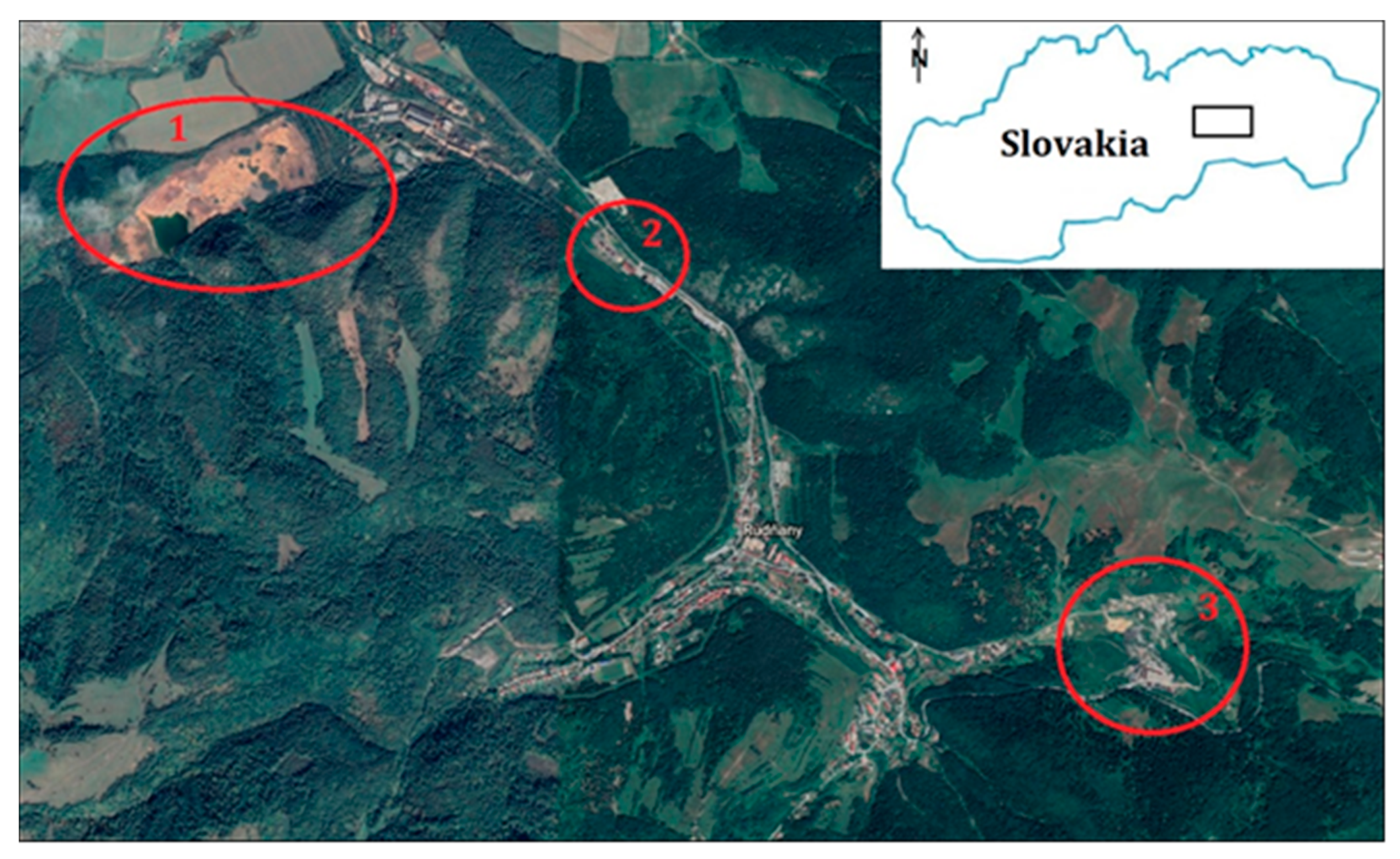
2. Geographical, Geological, and Historical Setting of the Examined Territory

Central Spiš is the central part of the vast historical region of Spiš in Eastern Slovakia, as shown in Figure 1. From the administrative point of view, it is predominantly located in the Košice Region, with only a small part reaching out to the Prešov Region. Within the Košice Region, Spišská Nová Ves and Gelnica are the districts belonging here, and in Prešov, it extends into the district of Levoča.
This territory is an old mining area. It is rich in mineral resources, especially copper and iron ore. In the past, intensive mining and industrial activities took place here, especially in the cadastral territories of Rudňany, Slovinky, and Krompachy. Rudňany Ore Field is built by layers of older and younger Paleozoic, Mesozoic, and younger cover formations of Tertiary and Quaternary. The oldest subsoil is formed by the so called rakovecká series phyllites [54,55]. The carboniferous layer is ore-bearing. Approximately 42 million tons of ore were mined in Rudňany for almost 700 years of mining, and the potential of reserves is approximately 100 million tons. If we deduct the ore mined, the majority of the geological reserves remain under ground. However, they are deep inside and of inferior quality, so today’s economists have declared them unbalanced; they are not interested in them. After 1989, the mining and processing industry started to decline in the region. The years 1992 and 1993 were an important milestone. Mining of stocks and unprofitable mining led to the mine being shut down and closed. The year 1993 was considered a milestone, when mining finished and critical plants, which contributed most to the pollution of the environment, were shut down in Rudňany and Slovinky.
Almost 30 years have passed since mining finished there but the impact of mining on the landscape and its components is a complex problem. Mining of raw materials leaves irreversible changes both underground and on the surface. On one hand, there are irreversible relief changes in the form of mining anthropogenic forms—undermined areas, caves, heaps, and tailing ponds. Their reclamation is very demanding. On the other hand, there is contamination of all environmental parts with heavy metals [56,57]. In the surroundings of Rudňany, there are high contents of heavy metals—Hg, Cu, Cd, Pb, Sb. It is estimated that in only 60 years of operation of an old ore heat treatment plant, several thousand tons of Hg got into the atmosphere, mostly in metallic form. From the new plant, about 142 tons of metallic Hg were released into the air and, subsequently, into the soil. The surroundings of Krompachy and Slovinky were again contaminated with heavy metals—As, Cu, and Zn. The decisive pollutants in the air, water, and soil are therefore heavy metals (Hg, As, Pb, Cd, Cu) and sulfur oxides, since sulfides are metal-bearing ores. In terms of the last complex environmental regionalization of Slovakia [58], the examined territory belongs to the Spiš–Rudňany district with a significantly disturbed environment. This territory covers an area of 364 km2 and has approximately 52,000 inhabitants. The research was carried out in four sites in the region—the Markušovce tailing pond, Pätoracké and Zabíjanec mining heaps, which belonged to the former mining area of Rudňany, as shown in Figure 2, and the Slovinky tailing pond.
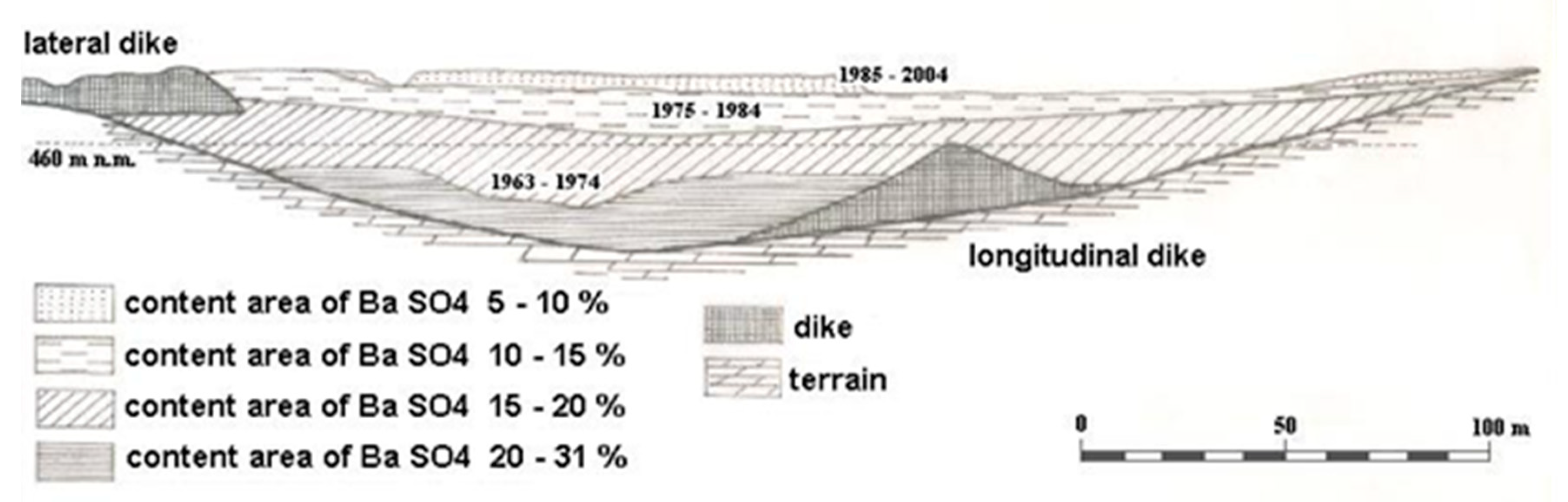
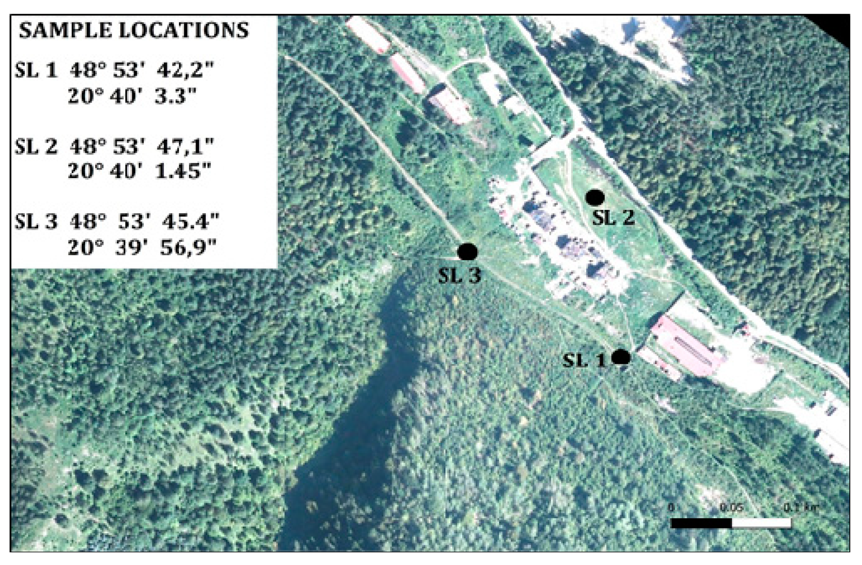
  • Site 1—Markušovce tailing pond
The tailing pond is located in front of the mouth of Markušovský brook into the valley of Rudnianský brook. It is situated on the border of cadastral territories of municipalities Markušovce (district Spišská Nová Ves) and Závadka pri Nálepkove (district Gelnica) in the Košice Region. It is located near the mining complex of the former plant Želba, a.s. Spišská Nová Ves in Rudňany. The shape of the tailing pond follows the relief of the lower part of the valley of Markušovský brook and is bounded by the present surface from above. The surface morphology is modeled by flotation sludge sedimentation, while the altitude reaches 478 m above sea level at the upper dam, and 474 m above sea level in the central part (so-called tailing pond mirror) and 477 m above sea level at the lower dam. The morphology inside the body is disrupted by the presence of the dam system of the old tailing pond, which was in operation until 1974, and bounded by a plain of 460 m above sea level from above, later covered by a new tailing pond to the present level from 474 m above sea level (water level), up to approximately 478 m above sea level (edges at the dam). The pond has a total length of approximately 1085 m and a width of 160–340 m. The area of the tailing pond in 1980 was about 10 ha, and currently it is 35 ha. The thickness of deposited materials is variable; the largest at the lower dam is 38 m thick. The current volume of sludge deposited is 9,901,160.00 tons.
The evolution of the tailing pond composition can be described in a simplified way by three stages with different influences on the internal characteristics of the bed, as shown in Figure 3.
  • Stage of the “old tailing pond”
It was created in the early stages of building the treatment complex in 1963–1974, while in addition to the front and side dams there was also a longitudinal southern dam separating the deposited part of the valley (to the level of approximately 460 m above sea level) from the non-deposited part with the brook and the original road at the bottom of the valley.
2.
“Middle section” stage
The original tailing pond was flooded (including the southern dam) after the upper and lower dams were raised and completed, the tunnel for draining Markušovský brook was excavated, and the lateral northern dam was built (development in 1975–1984, reached approximately 470 m above sea level).
3.
The “poor packaging” stage
Originating in the years 1985–2004, it is characterized by reduction in the content of useful ingredients in the by-products of the treatment due to radically improved ore flotation parameters. In recent years, the surface morphology of the tailing pond has been changed by flotation sludge mining. Extraction of upper layers had some influence on industrial exploitable sands (on the filling of gas pipelines).
The tailing pond has a complicated internal structure, as shown in Figure 4, due to the different distribution of components and size fractions represented. When sludge is deposited in the tailing pond, substances of different granulometrics and different specific weights are separated. This is influenced by the development of treatment technologies and their efficiency and by the composition of the ores extracted. The internal construction reflects the development of treatment of mined ores from the construction of the so-called new industrial plant in 1963 to the present. In the initial phase in 1963–1970, the treatment technology was not sufficiently mastered. Since 1984, the flotation process has improved and the treatment parameters of the BaSO4 component have substantially improved. The internal structure is also influenced by the natural gravitation classification of substances during its deposition when the grains of different sizes and specific gravity behave differently. Larger and heavier grains settle at the beginning of depositing, while finer and easier grains travel from the outlet to the center of the pool. In general, the central part of the tailing pond is represented by a rather finer material and a lower proportion of barite, and the edges of the tailing pond by rougher proportions and a relatively higher proportion of barite [59].
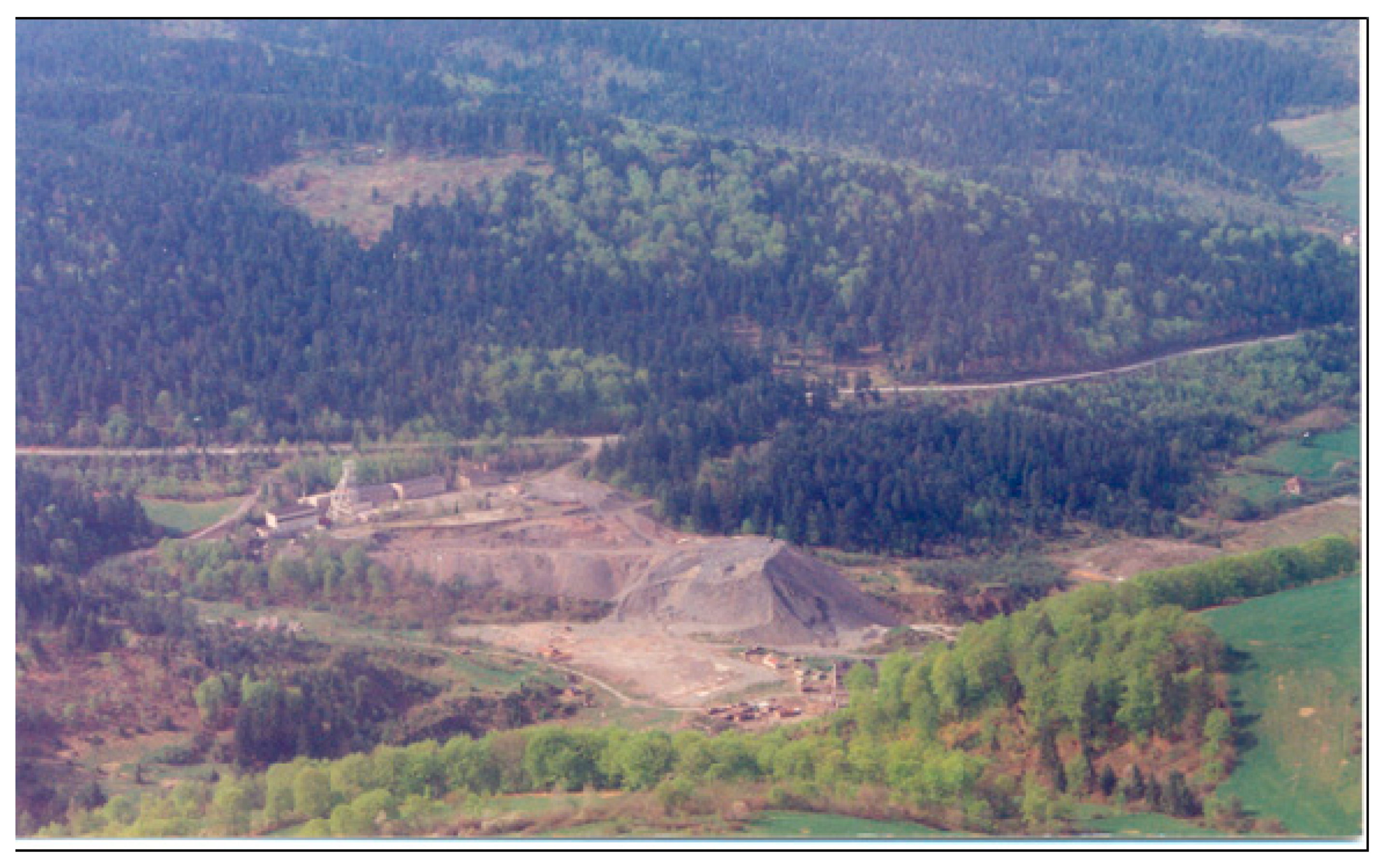
  • Site 2—Zabíjanec heap
There is a permanent human settlement on this site—the Roma ethnic settlement, as shown in Figure 5. The Roma moved to the abandoned factory in Zabíjanec in the early 1970s. This settlement is located directly in the former industrial zone and is about a kilometer from the village. Two of the buildings were built as administrative buildings of the mining company. The area served as a place for ore collection and a transport hub. In 1965, the company moved its activities closer to the mining sites and this zone remained abandoned [60].
The sources of pollution in this settlement are twofold. First, there are toxic dumps from mining operations. As these heaps are on a hill above the settlement, in case of rain and melting snow, water with a high content of heavy metals flows into the settlement and pollutes the soil. Residents involuntarily carry contaminated soil to their homes. The second source of pollution results from the industrial zone itself, on which the settlement is built. There are remains of heavy metals, oils, and other industrial materials in the soil [60]. Children playing around are exposed to toxins with long-term health effects, including the risk of neurological damage [61].
In 2007, a project was implemented to build a pump to provide drinking water to the community. The locals, however, quickly damaged it and made it out of order, and also dismantled drainage pipes. For drinking water, they have to walk about 2 km to wells, either to the new plant or to the village. The poor hygienic situation is manifested by the increased sickness rate of inhabitants (especially children).
  • Site 3—Pätoracké heap
Pätoracké used to be the most preferred part of Rudňany in the past. In the 1950s and 1960s, the mining company built flats and entire infrastructure for its employees. Two residential buildings were designed for middle and top management of the company. This area was a fully functioning part of the municipality with the necessary infrastructure, schools, offices, and shops. In the 1970s, mining activities began to threaten the area with terrain slides. Several kilometers of mining corridors are located just below the settlement. The deepest underground structures reach up to 900 m below the ground surface. The first incident with collapsing houses took place in the early 1970s. The authorities declared this area a vulnerable zone. The plant decided to move all residents to newly built flats in Spišská Nová Ves and Smižany. It is estimated that about 2700 people were moved. With the exception of two three-story office buildings, all buildings and the entire infrastructure were decommissioned and destroyed. These buildings remained despite the fact that the mining and processing company received money from the state budget to remove all buildings and infrastructure as part of the program to demolish the vulnerable zone. As mentioned above, the Roma were subsequently resettled into these buildings, creating a segregated settlement here [60]. Subsequently, the Roma community grew, both by natural population growth and occasional migration from other settlements. However, mining activities in this area were not interrupted and waste from mining continued to accumulate in the vicinity of the Roma community [62].
The Pätoracké Roma settlement, as shown in Figure 6, is one of the most endangered Roma settlements in the entire region of Central and Eastern Europe [63]. As a result of the former mining activity and industry, the entire settlement area is contaminated by toxic emissions, dumps, and left-over tailings. The settlement itself is located in the cave zone of former mines in the dump of mining waste, which is highly contaminated with heavy metals and where secondary mineralization and emissions to the surrounding environment (air in the form of dust and water in the form of leaches) take place. The majority of the population was once evacuated from this place because of terrain movements and slides that threatened local houses [61,64]. Sporadically, there occur slides, and larger caving occurred in 2001, 2009 (when a crater with a diameter of 10 m developed), and 2011.
Until 1989, local authorities and the management of the company did not take any steps to resolve the unfavorable situation. The growing pressures of the media and the new political system criticized the living conditions in Pätoracké. In the first phase, 31 new flats were built for 270 Roma living in Pätoracké. The apartment buildings are located several hundred meters above the original settlement in a renovated administrative building of a former mining company. Roma from the houses most vulnerable to landslides were moved here. Landslides are not a danger for the new area, but even the apartment buildings provided are surrounded by dumps of mining waste. The incentive to deal with the emergency situation concerning the rest of the Roma community has gradually disappeared and over time the prevailing situation has been considered normal again [60]. According to the mayor of the municipality, the area is supervised by the mining authority, which is responsible for remedying the problem. However, this body is not interested in pushing the state to move the Roma out of the vulnerable zone. The municipal authority, on the other hand, does not have the means to remediate this area.
The village has several times unsuccessfully warned the settlers that they live on the territory of the past mining activity, on which no cottages should be situated. However, the Roma continue to live in a zone at risk of subsidence and landslides. Only one outdoor water supply from a forest well serves the whole community in the Roma settlement. They do not have a sewage system or sewage treatment plant, which results in the poor hygienic situation. Due to the absence of waste collection and habits of local residents, this space is surrounded by rotting garbage.
  • Site 4—Slovinky Tailing Pond
The tailing pond, as shown in Figure 7, is located in the cadastral area of Krompachy. Although it is located on the territory of the town of Krompachy, it belonged to the mine of Slovinky. The construction of a new tailing pond started after an accident and the shutting down of the old one. It was in operation between 1968 and 1993 when the deposit was closed. The transport of sludge in the form of a hydro-mix from the ore treatment plant to the tailing pond was provided by three pumping stations connected in series along the sludge route. Approximately 4275 tons of flotation waste were annually stored in the tailing pond. It is a tailing pond with the highest sludge thickness in Slovakia; the height of the dam is 113 m. The tailing pond, where one million tons of arsenic sludge are stored, has a drain built up, but it gets stuck relatively easily during rain or melting snow.
There are two layers in the vertical section of the tailing pond. The upper part of Slovinky tailing pond consists of dark slag from the Kovohuty Krompachy plant, thickness 5–6 m, under which flotation sludge originating from the processing of siderite-sulfide ores is placed. The pond is dry, and the surface layer is not reclaimed. The mineral material of the pond consists mainly of quartz, siderite, chalcopyrite, tetrahedrite, arsenopyrite, and pyrite. Analyses of the overall composition of the tailing pond material revealed a significant difference in the composition of the top slag layer and the deeper deposited flotation sludge. Of the potentially toxic elements that may be a potential environmental risk, increased concentrations were found in the upper layer of the tailing pond (slag) and at the bottom of the tailing pond, especially the values of Cu, Zn, Cr, Pb, Ba, Sn, As, and Sb.
In 2010, on 4 October, there was an incident in the Ajka tailing pond in Hungary. Part of the tailing pond dam was damaged, and the red sludge covered three municipalities lying lower. There were 10 casualties in this tragedy, and over 200 people were injured and several hundreds of houses were not able to be inhabited any longer. After the above tragic event in Hungary, monitoring of all tailing ponds in Slovakia was carried out and it was found out that the condition of this tailing pond is unsatisfactory and there is a high risk of ecological incident. The current state of the tailing pond, and the one of the dam and drainage system is not satisfactory; it is mainly dangerous in the case of heavy rain. There is a natural and anthropogenic devastation not only of the dam body but also of the measuring and operational equipment (rainfall erosion on the slope, clogging of stone drainage troughs by drifted and broken concrete debris, disassembly and plucking of the drainage system, and the risk of stealing the metal covers in order to get money for them, breaking concrete reinforcements, cutting down tree vegetation ensuring the stability of the slope on the dam, etc.). The tailing pond has a private owner who is not interested in his property. Illegal four-wheeler races take place in the tailing pond.

3. Materials and Methods

3.1. Sediment Sampling

Sediment sampling was performed in all four sites in the studied area, as shown in Figure 8, Figure 9, Figure 10 and Figure 11. Samples were sent to the laboratory for heavy metal content. The samples were analyzed in the accredited testing laboratory of the Ministry of the Environment of the Slovak Republic for Geology and the Environment according to STN EN ISO/IEC 17025: 2005. The content of Cu, As, Pb, Ni, and Cr was determined by RFS—X-ray fluorescence spectrometry, and the content of Cd and Co was determined by AAS—atomic absorption spectrometry. In addition to internal controls, checking the correctness of laboratory techniques in the laboratory is regularly ensured by an external control system in the form of inter-laboratory comparative tests with a success rate of more than 90% of all extents for all soil and water types. The measured values of heavy metals were compared with the limit values of hazardous substances stipulated by Act No. 220/2004 on the Protection and Use of Agricultural Land and on the Amendment of Act No. 245/2003 Coll. on Integrated Prevention and Control of Environmental Pollution. Values exceeding the limits of individual heavy metals were graphically described by using the so-called traffic lights method [44]. Values that meet the legal standard are green. For over-limit values, we have calculated how many times the limit value has been exceeded. Subsequently, we determined the intervals for exceeding the limit values, which correspond to the shades of orange to red.

3.2. Public Opinion Poll

For the purposes of this study, a poll survey was prepared according to the general methodology of questionnaire development [65,66]. The survey consisted of 16 questions with a predetermined range of possible answers. The questions were prepared according to the aim of this study, focusing on alternative use of these sites, especially in geotourism and educational process. Respondents were students of the Department of Geography and Applied Geoinformatics Faculty of Humanities and Natural Sciences in Prešov; a total of 160 persons of 4 groups of 40 persons (aged 18–20 years) who visited all the sites as part of their field training. Respondents were not informed in advance that they would take part in a poll survey, they filled it in immediately after completing the route, and they received a detailed expert commentary about each site. The results of the poll survey were then analyzed, recalculated and rounded to a percentage, and processed for the purposes of publication in a scientific journal.
Poll Survey
(questions and a predetermined range of answers)
  • Did you have sufficient information about the mining history of this region before the visit?
    • (1a) Yes, I had detailed information
    • (1b) I had only basic information
    • (1c) No, I had no information
  • Can you define the concept of mining tailing ponds and mining heaps as mountain relief forms?
    • (2a) Yes, I can
    • (2b) No, I cannot
  • Have you ever visited other regions with mining and industrial remnants including tailing ponds and heaps?
    • (3a) Yes, several times
    • (3b) Yes, once
    • (3c) No, never
  • What is the visual impact of Slovinky and Markušovce tailing ponds and of mining heaps in Rudňany?
    • (4a) Negative and depressive, a foreign element in the landscape
    • (4b) Normal, natural part of the landscape after an intensive mining and processing activity
    • (4c) Positive, an interesting anthropogenic element
  • Evaluate the safety of these sites—Slovinky tailing pond
    • (5a) Satisfactory condition
    • (5b) Unsatisfactory condition
    • (5c) Disastrous condition
  • Evaluate the safety of these sites—Markušovce tailing pond
    • (6a) Satisfactory condition
    • (6b) Unsatisfactory condition
    • (6c) Disastrous condition
  • Evaluate the safety of these sites—mining heaps Rudňany
    • (7a) Satisfactory condition
    • (7b) Unsatisfactory condition
    • (7c) Disastrous condition
  • In your opinion, what impact do these sites have on the state of the environment and human and animal health?
    • (8a) Very negative
    • (8b) Slightly negative
    • (8c) Neither negative nor positive
  • What is the primary task of the competent authorities/persons in relation to these sites?
    • (9a) Ensure regular monitoring of the territory
    • (9b) Transfer of ownership from private to state hands
    • (9c) Use in geotourism, together with other objects after the former mining activity
    • (9d) Use in educational process in schools
    • (9e) Remediation of damaged parts and gradual reclamation
    • (9f) Further processing of material in the tailing pond, extraction of precious metals (Au, Ag)
    • (9g) Prevent uncontrolled visits to these sites
    • (9h) Remove illegal dwellings within the reach of such sites
  • Are these sites suitable for geotourism and education in schools?
    • (10a) Yes, they are
    • (10b) No, they are not
  • Would it be appropriate to build orientation and information boards at these sites?
    • (11a) Yes
    • (11b) No
  • Would it be suitable to mark a hiking trail leading to these sites?
    • (12a) Yes
    • (12b) No
  • Would it be suitable to have a tourist guide in these sites?
    • (13a) Yes
    • (13b) No
  • Would you suggest to include these sites as part of the so-called mining route?
    • (14a) Yes
    • (14b) No
  • Using these sites in the educational process, should they be included in:
    • (15a) Geography
    • (15b) Environmental study
    • (15c) History
  • Using these sites in the educational process, what would you prefer:
    • (16a) Present them in classes at school
    • (16b) Present them directly on the spot

4. Results

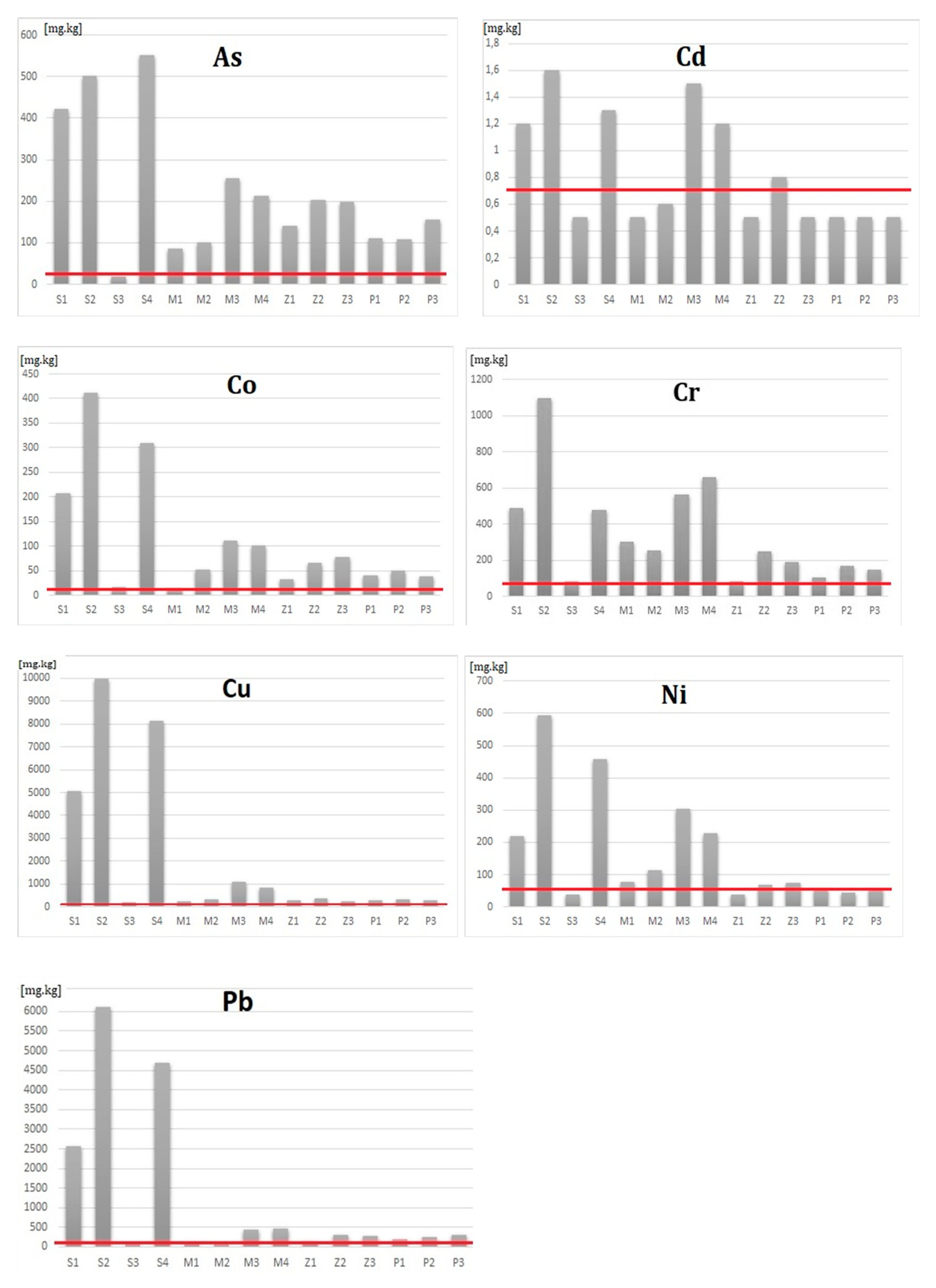
4.1. Analysis of the Heavy Metal Content

The results of analyses of heavy metal content in all four sites show us an enormous burden of the area in most cases, which exceeds the content limits of these elements several times in soil sediments. In the case of Markušovce tailing pond, as shown in Table 1, Figure 12, samples were taken at four locations, as shown in Figure 8—directly from the tailing pond (SL3, SL4), the dam (SL1), and the small mound in close proximity to the “mirror” covered by bushes (SL2). In terms of content of Cu, limit values were exceeded in the interval 10.1–20 times for SL3 and SL4. For SL2, it was 5.1–10 times. Content of As was exceeded in the interval 10.1–20 times for SL3, in SL4 it was in the interval 5.1–10 times. The content of other elements at the locations SL3 and SL4 (Pb, Ni, Cr, Co) was usually exceeded in the interval 5.1–10 times. For SL1 and SL2, the limit exceedance interval ranged from 0 to 5 times for most elements. The limit values were not exceeded for Cd (SL1, SL2), Pb (SL2), and Co (SL1).
In case of Zabíjanec mining heap, as shown in Table 2, Figure 13, samples were taken at three locations, as shown in Figure 9—one directly from the surface of the heap (SL2) and two more in close proximity, all near the Roma settlement. Content of As reaches the highest value in all three locations, which exceeds the limit in the interval 5.1–10 times. There is also the content of Cu (SL2) and Co (SL3) in this interval. Most of the other elements in all locations are within the 0–5 times limit. The limit of Cd (SL1 and SL3) and Ni (SL1) was not exceeded.
In case of the Pätoracké mining heap, as shown in Table 3, Figure 14, samples were taken at three locations, as shown in Figure 10—south-east of the heap edge in the forest (SL1), directly on the surface of the heap body (SL2), and north-west in close proximity to the Roma settlement (SL3). Here the content of Cu (SL2) and As (SL3) was exceeded in the interval 5.1–10 times. Most other elements exceed limit values in the range of 0–5 times. For Cd at all three locations and Ni (SL2), the limit values were not exceeded.
In case of Slovinky tailing pond, as shown in Table 4, Figure 15, four samples were taken, as shown in Figure 11—directly from the tailing pond “mirror” (SL2, SL4), the dam (SL1), and 70 m south-west of the tailing pond mirror (SL3). The analysis clearly shows that in the tailing pond the limit values are exceeded to the greatest extent out of all four monitored tailing and heap sites. The worst results are related to Cu, where the limit values at the sampling location SL2 are exceeded 165 times and at the sampling location SL4, 135 times. Exceeding values also relate to the content of As, Pb, and Co. Heavy metal contamination concerns not only the tailing pond but also its surroundings. The limit values were not exceeded at SL3 for As, Cd, Pb, and Ni.

4.2. Public Opinion Poll

We analyzed the poll survey results and calculated the percentages, as shown in Table 5. Most of the respondents had only basic information about the mining history of the Central Spiš region before visiting it, and approximately one third had no information at all. Forty percent of respondents were able to define the concept of a tailing pond and a heap. More than half of the respondents have visited at least one other region with anthropogenic mountain forms of relief before. According to three-quarters of respondents, the above sites make a negative or depressing impression, and are perceived as a foreign element in the landscape. The safety condition of the Slovinky tailing pond is considered to be unsatisfactory by 98% of respondents. In the case of the Markušovce tailing pond, it is considered as unsatisfactory by two-thirds of the respondents. More than half of the respondents also consider the state of both heaps to be unsatisfactory. According to 56% of respondents, the above sites have a very negative impact on the condition of the environment and human and animal health.
The majority of respondents (22%) considers the primary task of the competent persons/authorities in relation to these objects to ensure regular monitoring of the area, which is absent. Approximately 20% of respondents can imagine these sites to be used in geotourism, along with other objects after the former mining activity, as well as in the educational process in schools. Fifteen percent of respondents consider remediation of damaged parts and gradual reclamation as the most important. The least respondents (5%) think the primary task should be further processing of the material in the tailing pond, as shown in Figure 16, the extraction of precious metals, as well as the removal of Roma dwellings within reach of these sites, as shown in Figure 17. Almost three-quarters of respondents consider these objects as suitable locations for education and use in geotourism. Approximately 60% of respondents find it appropriate to build a marked hiking trail to these sites, as well as to build orientation and information boards in the area of these sites. More than two-thirds of respondents would like to be accompanied by a professional person in these objects and more than half of the respondents propose to include these sites as part of the “mining route”—a kind of adventure tourism in the mountain regions of Slovakia. Using these objects in the educational process, 71% of respondents propose to include information about them in geography lessons, based on a presentation on the spot (72%).

5. Discussion

The heavy metal content in the researched sites, as shown in Figure 18, is very high, and in some cases extreme, in accordance with the data for tailing ponds in the works of other authors [56,57]. It often exceeds the limit values several times. This burden is enormous for all monitored elements, especially in the case of the Slovinky tailing pond. Occurrence of these elements in the tailing ponds and heap bodies, as well as their possible penetration into the environment through, e.g., leaks, represents great danger for the landscape. This results in possible contamination of surface and ground water, and in windy weather it is difficult to breathe in the surroundings of these sites. An alarming fact is the existing settlement directly on the body of both heaps, namely the settlement of the Roma ethnic group, as well as the proximity of human settlement in the case of both tailing ponds.
The assumptions and research questions set during the implementation of the first part of the objective of the paper were confirmed. The load of these sites with heavy metals is enormous and exceeds the limit values several times. e.g., in the case of the Slovinky tailing pond, the limit values are exceeded more than 100 times for some elements. The higher load of heavy metals in tailing ponds than in heaps was also confirmed. We attribute this fact to a longer period of sediment deposition on tailing ponds and also to the combination of waste from mining and industrial activities.
From the point of view of alternative uses of the Slovinky tailing pond, it is possible to consider its inclusion as an object of geotourism. However, its emergency condition should be repaired first of all. The tailing pond should pass from private to state hands and the state should provide the necessary basic adjustments to the tailing pond and regular monitoring. Above all, to prevent the devastation and theft of the equipment by building fencing or thanks to a guard service, clean the surface drainage troughs of debris, to fill and align depressions with temporary ponds on the dam, prevent movement of motorcycles and four-wheelers on the surface of the tailing pond, use a suitable emulsion to form a shell on the surface of the tailing pond in order to prevent the transfer of dust particles by wind to the environment, and the like. It would be advisable to build wooden walkways on both sides of the upper terrace with a viewing platform in the middle to prevent visitors from contacting the sediment of the tailing pond. It would be advisable also to reinforce the access pavement with the possibility of installing information boards on the pavement around the tailing mirror. Visits to the pond should be conducted by a person with sufficient professional and safety insight and visits should not be organized in windy weather to prevent dust particles from entering the visitors’ respiratory tract.
In the case of the Markušovce tailing pond, it would be necessary to stop the unregulated sediment mining. Similarly, as in the case of the Slovinky tailing pond, it would be necessary to build wooden walkways in the area of the upper terrace of the tailing pond with a viewing platform and information panels. It would also be necessary to modify the access pavement. The hiking trail around the tailing pond body, unlike the Slovinky tailing pond, is not desirable as the area is overgrown with vegetation and the cost of building a circular walkway would be high. The tailing pond is occasionally used in the film industry, as shown in Figure 19, as it looks sufficiently “dark and spooky” and interesting, so the shooting part of the scenes takes place here—as recently as in 2018 (filming the fairy-tale Perinbaba 2).
In the case of the Zabíjanec and Pätoracké mining heaps, their use in geotourism is questionable. These heaps are permanently inhabited and assumingly the residents would mind if strangers would enter their houses. In the area of Central Spiš, there are several other more easily accessible and better secured heaps that could be used in geotourism, e.g., Poráč, Slovinky. The primary task for both of these sites should be removal and destruction of Roma settlements in this undermined and life and health hazardous area, and subsequent reclamation and securing of the area. Residents of these heaps should be provided with more suitable premises for housing in more environmentally friendly conditions with higher housing standards.
Sustainable tourism, whose object would be the mentioned sludge ponds, must among other general requirements and regulations for sustainable tourism accept also specifics of the very nature of sludge as an atypical tourism object in the landscape. These are in particular the following requirements:
  • Coordination of tourism entities with the involvement of sludge ponds in the tourism offer at national and international levels;
  • Advertising campaigns—publishing promotional materials, participation in tourism fairs, workshops, website creation, etc.;
  • Provision of traffic and tourist signs—information boards, marking the tourist destinations and trails on highways and roads, etc.;
  • Creation of a symbol, brand, or logo of sludge as a specific object of geotourism production of souvenirs, cooperation with artists, producers of art objects by art schools, competitions;
  • Roads, parking lots, and sanitary facilities construction and treatment—analysis of the infrastructure construction and its impact on tourism development, especially in terms of transport accessibility of sludge ponds;
  • Restoration, maintenance, and use of historical monuments in the area of sludge ponds—e.g., maintenance of mining equipment;
  • Organization of educational and cognitive events in the area of sludge ponds—for school groups, professionals, the general public;
  • The use of new information technologies in the supply and distribution of geotourism products—monitoring the development trends, cooperation with entities that provide services and products in the field of informatization of society;
  • Improving accommodation and catering capacities in the vicinity of sludge ponds—support the providers of accommodation and catering services in the region while promoting their facilities, etc.;
  • Education of experts in geotourism with a focus on sludge ponds—to incorporate the topic into the teaching process at universities, etc.;
  • Education of the population—support of activities aimed at a conscious relationship with the region, involvement of the local population in promotion, etc.;
  • Ensuring the safety, health, and life protection of visitors—preventing contact of visitors with sediments of sludge (in the case of deposited materials with possible evolution of dust particles) by building wooden sidewalks, viewing platforms, and respiratory protection in windy weather, etc.
The assumptions and research questions set before the public opinion poll were confirmed. Respondents consider these objects to be more suitable for use in education than in tourism. Upon visual perception, they consider them to be negative elements in the landscape and consider them to be a significant source of contamination.
In the case of the possible use of both tailing ponds in geotourism or as excursion sites for education, the safety of visitors should also be solved. It would be necessary to prevent the contact of visitors from the sediments of the tailing ponds by building wooden sidewalks and viewing platforms. Visitors should not be allowed to visit these sites in windy weather, or they should use respiratory protection.
In terms of significance and benefits, the paper provides current data on the environmental loading of heavy metals in the area, which confirms the multiple exceedances of limit values and builds on the publications of other authors [7,8,12,15,56,57,58,59], who analyzed the impact of heavy metals in both tailing ponds. The article provides an information base for further research in the area of tailing ponds and more detailed analysis of the environmental loading of individual landscape elements. The mentioned analysis confirms the enormous burden of tailing ponds with deposited heavy metals in the sense of similar tailing pond research in other areas of the world [5,6,9,14,17,19,20,21,22,23,24,30]. The analysis of the heavy metal content on both mining heaps has not been performed. The data presented in this paper are the first statistical indicators and confirm the increased content of some elements in the sediments of both mining heaps, which are also inhabited. These data were also provided to the local governments to which these sites belong, and they could help the competent authorities with improving the landscape management and with the protection of the population.
The second part of the paper deals with the alternative use of these four sites in terms of geotourism or education. The results of the public opinion poll show the suitability of the environmentally degraded areas, especially in education, to a lesser extent also in geotourism, thus confirming the possibility of transforming sites for alternative use in terms of publications [44,48,49,50,51,53].
The implementation of geotourism in the studied sites brings along benefits not only for visitors and students, but also has a positive impact on sites themselves and on the local community. Geotourism as a form of tourism is governed by its principles. The most important of them for the case of the studied area is the integrity of a place, which enhances the geographical character of the destination by developing and improving it in ways distinctive to the locale. It encourages market differentiation and cultural pride in ways that are reflective of natural and cultural heritage. Another important principle of geotourism for the development of the area is community benefit, which encourages micro- to medium-size enterprises and tourism business strategies that emphasize economic and social benefits to involved communities, especially poverty alleviation, with clear communication of the destination stewardship policies required to maintain those benefits. These principles of geotourism, as well as education, will contribute to raising awareness of the sites and their subsequent revitalization and further development.
The questions in the public opinion poll provide a suitable methodological apparatus for the assessment of environmentally degraded areas in terms of their use for geotourism and education. It is actually a first-of-its-kind assessment of tailing ponds and heaps as potential geotourism and education sites. This type of research has not been realized in Slovakia yet. The research and results provide a suitable apparatus for educating the students and the outputs are also applicable to local government and organizations focusing on the issue of environmentally degraded areas.
During the implementation of field research sampling and public opinion polling, certain limits and problematic areas were revealed. Due to the remoteness and inaccessibility of both sludge ponds, it was necessary to move on foot to the sites. The collection was carried out in windy weather, and it was necessary to use respiratory protection. It was also necessary to clean shoes and clothing from dust and to obtain the consent of the inhabitants of the heaps to take samples. In the case of a public opinion poll, more relevant results would be brought about by expanding the circle of respondents beyond students. Therefore, it would be necessary to formulate questions more generally with the focus on alternative uses of these sites. A certain weak point of the questionnaire was the narrowly specified circle of respondents, consisting exclusively of university students of geography. This also results in a greater focus of the questions in the questionnaire on the use of these sites in the educational process than in tourism.

6. Conclusions

The Slovinky tailing pond, the Markušovce tailing pond, and the Zabíjanec and Pätoracké mining heaps act as a distinct anthropogenic element set in the forest environment of Hnilecké vrchy mountains in the environmentally burdened area of Central Spiš in eastern Slovakia. They represent relics of extinct mining activities in the region, focusing mainly on iron and copper ores. During and after approximately 30 years of active operation, all elements of the natural environment of the area, as well as of man, have been and still have a significant impact on the natural environment. Especially, the enormous heavy metal content in sediments of these bodies represent a danger.
If these objects are used in geotourism and education, it is necessary to modify the bodies and surroundings of both tailing ponds in order to prevent the visitors from contacting the sediments of the tailing ponds. We do not consider the Zabíjanec and Pätoracké mining heaps to be suitable objects of geotourism because of the present Roma settlement. The residents would mind if strangers would enter the area near their houses.
The paper points at the current state of these objects in terms of their heavy metal burden and considers their possible alternative use, especially in terms of geotourism or in education. In the future, it would be advisable to extend the poll survey among the inhabitants of the region and self-governing bodies and to ensure continuous monitoring of the condition of these objects. The purpose of such a survey would be to determine the attitude of the local population, or the self-government to these objects, to get an idea of their perception and opportunities for further development of the territory. The survey would find out the attitude of these respondents in terms of the suitability of involving these sites as tourist destinations, and would analyze the potential pros and cons for local people and the self-government.

Author Contributions

V.Č. completed the text part of the paper; V.Č., J.K., and V.K. ensured the field research and sampling, analyzed the heavy metal content analysis; B.G. and P.H. were in charge of preparation, implementation, and analysis of poll surveys, M.M. and J.H. elaborated the theoretical-methodological part, and the cartographic and graphical appendix. All authors have read and agreed to the published version of the manuscript.

Funding

This research was funded by grant number APVV-18-0185: Transformácia využívania kultúrnej krajiny Slovenska a predikcia jej ďalšieho vývoja (Transformation of Using the Cultural Country of Slovakia and Prediction of Its Further Development) and grant VEGA 1/0236/18: Environmental Aspects of Mining Localities Settings in Slovakia in the Middle Ages and the Beginning of Modern History.

Acknowledgments

The authors would like to thank anonymous reviewers for their helpful and constructive comments and suggestions that greatly contributed to improving the final version of this paper.

Conflicts of Interest

The authors declare no conflict of interest. The funders had no role in the design of the study; in the collection, analyses, or interpretation of data; in the writing of the manuscript, or in the decision to publish the results.

References

  1. Čech, V.; Krokusová, J. Antropogénna Geomorfológia (Antropogénne Formy Reliéfu); University of Prešov: Prešov, Slovakia, 2013; p. 179. [Google Scholar]
  2. Kirchner, K.; Smolová, I. Základy Antropogenní Geomorfologie; Univerzita Palackého Olomouc: Olomouc, Czech Republic, 2010; p. 287. [Google Scholar]
  3. Szabó, J.; Lóránt, D.; Dénes, L. Anthropogenic Geomorphology—A Guide to Man-Made Landforms; Springer: Berlin/Heidelberg, Germany, 2010; p. 298. [Google Scholar]
  4. Zapletal, L. Úvod do Antropogenní Geomorfologie; Univerzita Palackého Olomouc: Olomouc, Czech Republic, 1969; pp. 1–320. [Google Scholar]
  5. Etigemane, H.; Muniswamy, D. Spatial Distribution of Heavy Metals around the Gold Mine Ore Tailings of Hatti, Karnataka State, India. Landsc. Environ. 2018, 11, 35–44. [Google Scholar] [CrossRef]
  6. Gutierrez, M.; Collette, Z.; Mcclanahan, A.; Mickus, K. Mobility of Metals in Sediments Contaminated with Historical Mining Wastes: Example from the Tri-State Mining District, USA. Soil Syst. 2019, 3, 22. [Google Scholar] [CrossRef] [Green Version]
  7. Hančuľák, J.; Bobro, M.; Šestionová, O.; Brehuv, J.; Slančo, P. Mercury in the environment of old mining areas of Rudňany and Mernik. Acta Montan. Slovaca 2006, 11, 295–299. [Google Scholar]
  8. Musilová, J.; Árvay, J.; Vollmannova, A.; Tóth, T.; Tomáš, J. Environmental Contamination by Heavy Metals in Region with Previous Mining Activity. In Proceedings of the 14th International Conference on Environmental Science and Technology, Rhodes, Greece, 3–5 September 2015. [Google Scholar]
  9. Wang, P.; Sun, Z.; Hu, Y.; Cheng, H. Leaching of heavy metals from abandoned mine tailings brought by precipitation and the associated environmental impact. Sci. Total Environ. 2019, 695. [Google Scholar] [CrossRef] [PubMed]
  10. Zhang, X.; Yang, L.; Li, Y.; Li, H.; Wang, W.; Ye, B. Impacts of lead/zinc mining and smelting on the environment and human health in China. Environ. Monit. Assess. 2011, 184, 2261–2273. [Google Scholar] [CrossRef] [PubMed]
  11. Demková, L.; Árvay, J.; Bobuľská, L.; Hauptvogl, M.; Hrstková, M. Open mining pits and heaps of waste material as the source of undesirable substances: Biomonitoring of air and soil pollution in former mining area (Dubnik, Slovakia). Environ. Sci. Pollut. Res. 2019, 26, 35227–35239. [Google Scholar] [CrossRef]
  12. Angelovičová, L.; Fazekašová, D. Contamination of the soil and water environment by heavy metals in the former mining area of Rudňany (Slovakia). Soil Water Res. 2014, 9, 18–24. [Google Scholar] [CrossRef] [Green Version]
  13. Bobro, M.; Maceková, J.; Slančo, P.; Hančuľák, J.; Šestinová, O. Wastes from mining and metallurgical activities in the water reservoir of Ružín. Acta Metall. Slovaca 2006, 12, 26–32. [Google Scholar]
  14. Concas, A.; Ardau, C.; Cristini, A.; Zuddas, P.; Cao, G. Mobility of heavy metals from tailings to stream waters in a mining activity contaminated site. Chemosphere 2006, 63, 244–253. [Google Scholar] [CrossRef]
  15. Demková, L.; Boguská, Z.; Fazekašová, D. Physico-chemical water properties and flora diversity under the old mining load influence (Rudnansky creek, Slovakia). Pollack Period. 2015, 10, 123–131. [Google Scholar]
  16. Gałuszka, A.; Migaszewski, Z.; Dołęgowska, S.; Michalik, A.; Duczmal-Czernikiewicz, A. Geochemical background of potentially toxic trace elements in soils of the historic copper mining area: A case study from Miedzianka Mt., Holy Cross Mountains, south-central Poland. Environ. Earth Sci. 2015, 74, 4589–4605. [Google Scholar] [CrossRef] [Green Version]
  17. García-Giménez, R.; Jiménez-Ballesta, R. Mine tailings influencing soil contamination by potentially toxic elements. Environ. Earth Sci. 2017, 76, 51. [Google Scholar] [CrossRef]
  18. Guo, X.L.; Gu, J.; Chen, Z.X.; Gao, H.; Qin, Q.J.; Sun, W.; Zhang, W.J. Effects of heavy metals pollution on soil microbial comunities metabolism and soil enzyme activities in coal mining area of Tongchuan, Shaanxi Province of Northwest China. Chin. J. Appl. Ecol. 2012, 23, 798–806. [Google Scholar]
  19. Li, Z.; Ma, Z.; Van Der Kuijp, T.J.; Yuan, Z.; Huang, L. A review of soil heavy metal pollution from mines in China: Pollution and health risk assessment. Sci. Total Environ. 2014, 468, 843–853. [Google Scholar] [CrossRef] [PubMed]
  20. Liu, H.; Probst, A.; Liao, B. Metal contamination of soils and crops affected by the Chenzhou lead/zinc mine spill (Hunan, China). Sci. Total Environ. 2005, 339, 153–166. [Google Scholar] [CrossRef] [PubMed] [Green Version]
  21. McGrath, S.P. Metal concentrations in sludges and soil from a long-term field trial. J. Agric. Sci. 1984, 103, 25–35. [Google Scholar] [CrossRef]
  22. Palanivel, T.M.; Victor, R. Contamination assessment of heavy metals in the soils of an abandoned copper mine in Lasail, Northern Oman. Int. J. Environ. Stud. 2020, 77, 432–446. [Google Scholar] [CrossRef]
  23. Pietrzykowski, M.; Antonkiewicz, J.; Gruba, P.; Pająk, M. Content of Zn, Cd and Pb in purple moor-grass in soils heavily contaminated with heavy metals around a zinc and lead ore tailing landfill. Open Chem. 2018, 16, 1143–1152. [Google Scholar] [CrossRef]
  24. Zawadzki, J.; Fabijańczyk, P. Geostatistical evaluation of lead and zinc concentration in soils of an old mining area with complex land management. Int. J. Environ. Sci. Technol. 2013, 10, 729–742. [Google Scholar] [CrossRef] [Green Version]
  25. Zhang, F.-P.; Li, C.; Tong, L.-G.; Yue, L.-X.; Li, P.; Ciren, Y.-J.; Cao, C.-G. Response of microbial characteristics to heavy metal pollution of mining soils in central Tibet, China. Appl. Soil Ecol. 2010, 45, 144–151. [Google Scholar] [CrossRef]
  26. Qu, J.; Ren, G.; Chen, B.; Fan, J.; Yong, E. Effects of lead and zinc mining contamination on bacterial community diversity and enzyme activities of vicinal cropland. Environ. Monit. Assess. 2011, 182, 597–606. [Google Scholar] [CrossRef] [PubMed]
  27. Schippers, A.; Jozsa, P.G.; Sand, W.; Kovacs, Z.M.; Jelea, M. Microbiological Pyrite Oxidation in a Mine Tailings Heap and Its Relevance to the Death of Vegetation. Geomicrobiol. J. 2000, 17, 151–162. [Google Scholar]
  28. Teper, E. Dust-particle migration around flotation tailings ponds: Pine needles as passive samplers. Environ. Monit. Assess. 2008, 154, 383–391. [Google Scholar] [CrossRef]
  29. Kicińska, A.J. Health risk to children exposed to Zn, Pb, and Fe in selected urban parks of the Silesian agglomeration. Hum. Ecol. Risk Assess. Int. J. 2016, 22, 1687–1695. [Google Scholar] [CrossRef]
  30. Obiora, S.C.; Chukwu, A.; Davies, T.C. Heavy metals and health risk assessment of arable soils and food crops around Pb–Zn mining localities in Enyigba, southeastern Nigeria. J. Afr. Earth Sci. 2016, 116, 182–189. [Google Scholar] [CrossRef]
  31. Chen, X.-W.; Wong, J.T.F.; Leung, A.O.-W.; Ng, C.W.-W.; Wong, M.H. Comparison of plant and bacterial communities between a subtropical landfill topsoil 15 years after restoration and a natural area. Waste Manag. 2017, 63, 49–57. [Google Scholar] [CrossRef] [PubMed]
  32. Gasidło, K. Problemy przekształceń terenów poprzemysłowych. Zesz. Nauk. Politech. Śląskiej Archit. 1998, 1408, 111–113. [Google Scholar]
  33. Jin, J.; Wang, R.; Li, F.; Huang, J.; Zhou, C.; Zhang, H.; Yang, W. Conjugate ecological restoration approach with a case study in Mentougou district, Beijing. Ecol. Complex. 2011, 8, 161–170. [Google Scholar] [CrossRef]
  34. Pełka-Gościniak, J. Restoring nature in mining areas of the Silesian Upland (Poland). Earth Surf. Process. Landforms 2006, 31, 1685–1691. [Google Scholar] [CrossRef]
  35. Koda, E.; Pachuta, K. Possibility of sanitary landfill rehabilitation with the use of self-growing plants. Ann. Wars. Agric. Univ. SGGW Land Reclam. 2001, 32, 41–50. [Google Scholar]
  36. Hose, T.A. Geotourism, or can Tourists become Casual Rock Hounds? In Geology on Your Doorstep; Bennett, M.R., Ed.; The Geological Society: London, UK, 1996; pp. 207–228. [Google Scholar]
  37. Buckley, R. Research Note Environmental Inputs and Outputs in Ecotourism: Geotourism with a Positive Triple Bottom Line? J. Ecotourism 2003, 2, 76–82. [Google Scholar] [CrossRef] [Green Version]
  38. Joyce, E.B. Geomorphological Sites and the New Geotourism in Australia; School of Earth Sciences, The University of Melbourne: Melbourne, Australia, 2006. [Google Scholar]
  39. Dowling, R.K. Geotourism’s global growth. Geoheritage 2011, 3, 1–13. [Google Scholar] [CrossRef]
  40. Dowling, R. Global Geotourism—An Emerging Form of Sustainable Tourism. Czech J. Tour. 2013, 2, 59–79. [Google Scholar] [CrossRef] [Green Version]
  41. Hose, T.A. The English Origins of Geotourism (as a Vehicle for Geoconservation) and Their Relevance to Current Studies. Acta Geogr. Slov. 2011, 51, 343–359. [Google Scholar] [CrossRef] [Green Version]
  42. Ólafsdóttir, R.; Tverijonaite, E. Geotourism: A Systematic Literature Review. Geosciences 2018, 8, 234. [Google Scholar] [CrossRef] [Green Version]
  43. Ruban, D.A. Geotourism—A geographical review of the literature. Tour. Manag. Perspect. 2015, 15, 1–15. [Google Scholar] [CrossRef]
  44. Goki, N.G.; Marcus, N.D.; Umbugadu, A.A. Preliminary assessment of the post-mining geotourism potential of the Plateau tin fields, Nigeria. Acta Geoturistica 2016, 7, 21–30. [Google Scholar]
  45. Rybár, P.; Štrba, L. Mining Tourism And Its Position In Relation To Other Forms Of Tourism. In Proceedings of the GEOTOUR 2016 Conference. International Conference on Geotourism, Mining Tourism, Sustainable Development, and Environmental Protection, 18–20 October 2016, Firenze; BIMET-CNR: Firenze, Italy, 2016; pp. 7–12. [Google Scholar]
  46. Conlin, M.V.; Jolliffe, L. Mining Heritage and Tourism: A Global Synthesis; Routledge Advances in Tourism; Routledge: New York, NY, USA, 2011. [Google Scholar]
  47. Długoński, A. Recreational development of old landfill: The case study of Górka Rogowska landfill in Łódźcity, Poland. Detritus 2018, 2, 155–162. [Google Scholar] [CrossRef]
  48. Kobylańska, M. Underground Track “St. Johannes” Mine & Tourist Route “By the traces of the former ore mining” in the Mirsk Commune as the example of post-mining relics’ management for geotourism. Acta Geoturistica 2013, 4, 32–38. [Google Scholar]
  49. Kršák, B. Cross-Border Project: Upper Hungarian Mining Route. Present Issues of Geotourism in Slovakia and Hungary; EuroScientia VZW: Wambeek, Belgium, 2011; pp. 7–16. [Google Scholar]
  50. Lopez, M.I.; Perez, L. Sustainable mining heritage tourism: Indicators and a methodological proposal for the former coal mining settlements of Lota and Coronel. EURE Rev. Latinoam. Estuidios Urbano Reg. 2013, 39, 199–231. [Google Scholar]
  51. Lorenc, M.W.; Janusz, M. How mining heritage can be used? Selected examples from Europe. CUPRUM 2013, 3, 17–32. [Google Scholar]
  52. Łukaszkiewicz, J.; Długoński, A.; Fortuna-Antoszkiewicz, B.; Wiśniewski, P. From the heap to the park—Reclamation and adaptation of degraded urban areas for recreational functions in Poland. Przegląd Nauk. Inżynieria Kształtowanie Sr. 2019, 28, 664–681. [Google Scholar] [CrossRef] [Green Version]
  53. Pérez-Álvarez, R.; Torres-Ortega, S.; Diaz-Simal, P.; Husillos-Rodríguez, R.; De Luis-Ruiz, J.M. Economic Valuation of Mining Heritage from a Recreational Approach: Application to the Case of El Soplao Cave in Spain (Geosite UR004). Sustainability 2016, 8, 185. [Google Scholar] [CrossRef] [Green Version]
  54. Mello, J.; Filo, I.; Havrila, M.; Ivan, P.; Ivanička, J.; Madarás, J.; Németh, Z.; Polák, M.; Pristaš, J.; Vozár, J.; et al. Geologická Mapa Slovenského Raja, Galmusu a Hornádskej Kotliny 1: 50 000; ŠGÚDŠ: Bratislava, Slovakia, 2000; Available online: https://www.worldcat.org/title/regionalne-geologicke-mapy-slovenska-150-000-geologicka-mapa-slovenskeho-raja-galmusu-a-hornadskej-kotliny-geological-map-of-the-slovensky-raj-galmus-mts-and-hornad-depression/oclc/55739876 (accessed on 10 April 2020).
  55. Mello, J.; Filo, I.; Havrila, M.; Ivan, P.; Ivanička, J.; Madarás, J.; Németh, Z.; Polák, M.; Pristaš, J.; Vozár, J.; et al. Vysvetlivky ku Geologickej Mape Slovenského Raja, Galmusu a Hornádskej Kotliny 1: 50 000; ŠGÚDŠ: Bratislava, Slovakia, 2000; p. 303. Available online: https://www.worldcat.org/title/vysvetlivky-ku-geologickej-mape-slovenskeko-raja-galmusu-a-hornadskej-kotliny-150-000/oclc/57531638 (accessed on 10 April 2020).
  56. Hiller, E.; Petrák, M.; Tóth, R.; Lalinská-Voleková, B.; Jurkovič, L.; Kucerova, G.; Radková, A.; Šottník, P.; Vozár, J. Geochemical and mineralogical characterization of a neutral, low-sulfide/high-carbonate tailings impoundment, Markušovce, eastern Slovakia. Environ. Sci. Pollut. Res. 2013, 20, 7627–7642. [Google Scholar] [CrossRef] [PubMed]
  57. Tóth, R.; Hiller, E.; Petrák, M.; Jurkovič, L.; Šottník, P.; Vozár, J.; Peťková, K. Odkaliská Markušovce a Slovinky—Aplikácia metodického postupu na hodnotenie odkaliskových sedimentov pochádzajúcich z úpravy rúd na modelových odkaliskách. Miner. Slovaca 2013, 45, 125–130. [Google Scholar]
  58. Klinda, J.; Mičík, T.; Némethová, M.; Slámková, M. Environmentálna Regionalizácia Slovenskej Republiky 2016; Ministerstvo Životného Prostredia Slovenskej Republiky: Bratislava, Slovakia, 2016; p. 134.
  59. Jančura, M. Záverečná Správa Geologicko-Prieskumnej Úlohy. Markušovce—Odkalisko, Prieskum Látkového Zloženia a Výpočet Zásob Vyhradeného Ložiska Markušovce—Odkalisko—Baryt; Rudohorská investičná spoločnosť: Spišská Nová Ves, Slovakia, 2004; p. 46. [Google Scholar]
  60. Steger, T.; Filčák, R. Articulating the Basis for Promoting Environmental Justice in Central and Eastern Europe. Environ. Justice 2008, 1, 49–53. [Google Scholar] [CrossRef]
  61. Antypas, A.; Cahn, C.; Filčák, R.; Steger, T. Linking environmental protection, health and human rights in the European Union: An argument in favour of environmental justice policy. Environ. Law Manag. 2008, 20, 8–21. [Google Scholar]
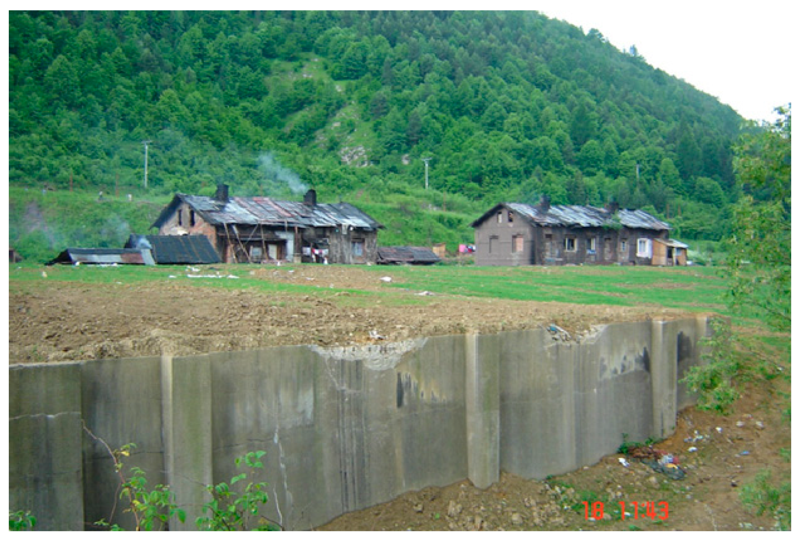
  62. Filčák, R. Environmental Justice and the Roma Settlements of Eastern Slovakia: Entitlements, Land and the Environmental Risks. Czech Sociol. Rev. 2012, 48, 537–562. [Google Scholar] [CrossRef]
  63. Cahn, C. It’s the Law: Local Official Responsible for Roma Slums; Local Governance Brief Policy Journal of the Local Government and Public Sector Reform Initiative: Budapest, Hungary, 2004.
  64. Filčák, R. Chudoba a Životné Prostredie: Prípad Marginalizovaných Rómskych Osád. Euractiv.sk Európska únia-portál o EÚ. 2004. Available online: https://euractiv.sk/section/rovnost-sanci/opinion/chudoba-a-zivotne-prostredie-pripad-marginalizovanych-roms/ (accessed on 22 April 2013).
  65. Švec, Š. Metodológia Vied o Výchove: Kvantitatívno-Scientické a Kvalitatívno-Humanitné Prístupy Vedukačnom Výskume; Iris: Bratislava, Slovakia, 1998; p. 300. [Google Scholar]
  66. Taylor-Powell, E. Questionnaire Design: Asking Questions with a Purpose; University of Wisconsin Extension: Madison, WI, USA, 1998; p. 18. [Google Scholar]
Figure 1. Position of the examined territory.
Sustainability 12 06029 g001
Figure 2. Examined sites within the former mining area Rudňany. 1: Markušovce tailing pond; 2: Zabíjanec heap; and 3: Pätoracké heap.
Sustainability 12 06029 g002
Figure 3. Stages of Markušovce tailing pond [28].
Sustainability 12 06029 g003
Figure 4. Structure of Markušovce tailing pond.
Sustainability 12 06029 g004
Figure 5. Site “Zabíjanec”—a Roma settlement directly in the area of the former mine on the levelled heap.
Sustainability 12 06029 g005
Figure 6. Aerial view of Pätoracké heap from 1993.
Sustainability 12 06029 g006
Figure 7. Aerial viewpoint of Slovinky tailing pond (on the left), bad condition of concrete drainage troughs (up on the right), and the tailing pond body surface (down on the right).
Sustainability 12 06029 g007
Figure 8. Sediment sampling places in the Markušovce tailing pond.
Sustainability 12 06029 g008
Figure 9. Sediment sampling places on the Zabíjanec heap.
Sustainability 12 06029 g009
Figure 10. Sediment sampling places on the Pätoracké heap.
Sustainability 12 06029 g010
Figure 11. Sediment sampling places in the Slovinky tailing pond.
Sustainability 12 06029 g011
Figure 12. Explanatory notes to Table 1: Intervals exceeding the limit values x-times.
Sustainability 12 06029 g012
Figure 13. Explanatory notes to Table 2: Intervals exceeding the limit values x-times.
Sustainability 12 06029 g013
Figure 14. Explanatory notes to Table 3: Intervals exceeding the limit values x-times.
Sustainability 12 06029 g014
Figure 15. Explanatory notes to Table 4: Intervals exceeding the limit values x-times.
Sustainability 12 06029 g015
Figure 16. Vegetation on the mirror of Markušovce, deposits in the background.
Sustainability 12 06029 g016
Figure 17. Roma settlement on the body of the Pätoracké heap.
Sustainability 12 06029 g017
Figure 18. Comparison of heavy metal content from all the sites with the limit value (red line). (S1–S4: Slovinky tailing pond, M1–M4: Markušovce tailing pond; Z1–Z3: Zabíjanec mining heap; P1–P3: Pätoracké mining heap).
Sustainability 12 06029 g018
Figure 19. Shifting the scenes in the Markušovce tailing pond (October 2018). Photo by M. Šimoňáková.
Sustainability 12 06029 g019
Table 1. Analysis of heavy metal content in the Markušovce tailing pond.
Heavy MetalUnitSL 1SL 2SL 3SL 4Limit
Cu(mg/kg)258325109685260
As(mg/kg)8510225621325
Cd(mg/kg)0.50.61.51.20.7
Pb(mg/kg)895944947570
Ni(mg/kg)7711230322850
Cr(mg/kg)30225656365870
Co(mg/kg)145211210215
SL1—tailing pond dam, SL2—bushes close to the body (mirror) of the tailing pond (north), SL3—body (mirror) of the tailing pond (south), SL4—body (mirror) of the tailing pond (south-west).
Table 2. Analysis of heavy metal content in the Zabíjanec mining heap.
Heavy MetalUnitSL 1SL 2SL 3Limit
Cu(mg/kg)28935825660
As(mg/kg)14220219825
Cd(mg/kg)< 0.50.8< 0.50.7
Pb(mg/kg)15729927870
Ni(mg/kg)37687550
Cr(mg/kg)8524718970
Co(mg/kg)32667815
SL1—behind the heap, SL2—directly on the heap, SL3—behind the heap in the forest.
Table 3. Analysis of heavy metal content in the Pätoracké mining heap.
Heavy MetalUnitSL 1SL 2SL 3Limit
Cu(mg/kg)27732929860
As(mg/kg)11210915625
Cd(mg/kg)< 0.5< 0.5< 0.50.7
Pb(mg/kg)20125029670
Ni(mg/kg)57445550
Cr(mg/kg)10216614570
Co(mg/kg)41503815
SL1—behind the heap, east part near the forest, SL2—directly on the heap, SL3—behind the heap close to the Roma settlement.
Table 4. Analysis of heavy metal content in the Slovinky tailing pond.
Heavy MetalUnitSL 1SL 2SL 3Limit
Cu(mg/kg)27732929860
As(mg/kg)11210915625
Cd(mg/kg)<0.5<0.5<0.50.7
Pb(mg/kg)20125029670
Ni(mg/kg)57445550
Cr(mg/kg)10216614570
Co(mg/kg)41503815
SL1—tailing pond body, SL2—body (mirror) of the tailing pond (north), SL3—forest 70 m south-west of the body (mirror) of the tailing pond, SL4—body (mirror) of the tailing pond (east).
Table 5. Percentage of individual answers in the poll survey.
Question Nr.AnswersPercentage
1a5
b60
c35
2a40
b60
3a23
b35
c42
4a76
b20
c4
5a2
b44
c54
6a21
b66
c13
7a8
b52
c40
8a56
b27
c17
9a22
b8
c18
d20
e15
f5
g7
h5
10a72
b28
11a62
b38
12a58
b42
13a68
b32
14a52
b48
15a71
b22
c7
16a28
b72

