Article

The Game of Developers and Planners: Ecosystem Services as a (Hidden) Regulation through Planning Delay Times

Faculty of Architecture and Town Planning, Technion—Israel Institute of Technology Haifa, Haifa 3200003, Israel
Sustainability 2020, 12(15), 5940; https://doi.org/10.3390/su12155940
Submission received: 26 June 2020 / Revised: 20 July 2020 / Accepted: 22 July 2020 / Published: 23 July 2020
(This article belongs to the Special Issue Urban Economics, City Development and Future Social Challenges)

Abstract

:
Planning delay time is a ubiquitous but under-researched land use regulation method. The aim of this study is to link planning delay time with the loss of urban locally provided ecosystem services (ULPES) caused by land development. Our main hypothesis is that the planning delay is an informal tool that ensures social welfare in a given urban area increases even if land is developed and the ULPES associated with the undeveloped land are lost. Whereas the developer’s objective is to maximize his profits, the planner’s target is to achieve the greatest social welfare, as calculated by considering public interest based on the value of open space and the developer’s expected profits. Our results show that, when the ULPES provided by an undeveloped parcel are sufficiently high, planning delay times can be used to prevent the execution of low quality initiatives and to only permit projects that improve general welfare and justify the potential ULPES loss. Planning delay times are interpreted as the expression of continuous negotiation between the interests of the public and those of real-estate developers, regarding the value of ULPES. The implication of the study is that ULPES values are introduced using a simple game-theoretic model allowing interaction between developers and planning authorities. The main significance is an alternative explanation for planning delay times as a consequence of ongoing negotiations between developers and urban planners that represent the general public in the city.

1. Introduction

Urban growth is the source of one of the most extensive and permanent land use changes worldwide [1]. Covering the natural land with impervious construction material, urban growth intensifies the transformation of green spaces near and within cities [2]. However, green and open land within urban areas provide several environmental services to urban dwellers [3]. One particularly elusive aspect of urban environmental impact is the issue of ecosystem services [4]. Ecosystem services are bundles of benefits that people obtain from natural ecosystems, even those located within urban areas [5]. However, the source of the ecosystem services available to urbanites is mainly green and open areas located within or around the city [4], which are usually under constant threat from ongoing development [6]. To make things worse, the ecosystem services provided by green urban areas are hard to measure [7], making it difficult to assess the negative external costs involved in the eventual replacement of these green areas by built structures.
Negative externalities usually justify planning intervention in urban land markets, aiming at, among other objectives, reducing the gap between the social and the private costs of land market outcomes [8]. Planning interventions in urban land markets should be designed with clear spatial objectives. Zoning regulations, adequate infrastructure provision, floor/area ratios and construction codes are examples of feasible and quantifiable urban planning tools [9]. However, there is also an additional type of urban planning instrument that is more subtle and not explicitly defined. In a planned city, any real-estate development project is submitted to the planning authorities in order to be approved. This approval process, usually called a “planning delay” [10], can be time consuming; its duration and outcomes are hardly predictable. The planning delay substantially impacts the developers’ decision-making, and likewise affects the resulting spatial pattern of the urban area [11]. However, despite the potential importance of the planning delay as a regulatory tool, its origins, causes and determinants are barely discussed in the literature [10]. The few available studies on planning delays focuses on their consequences, either on urban dwelling markets ([10,12,13] or on urban spatial development ([11,14,15]). However, studies regarding the possible reasons behind the implementation of planning delays by regulatory bodies are not available. This paper aims to fill this gap by linking planning delay practice with uncertainties related to urban ecosystem services valuation.
Our main hypothesis is that the planning delay is an informal tool that ensures social welfare in an urban area increase even if green land is developed. Since any planning delay results in financial losses to the real-estate developer, the willingness to wait in order to fulfil the project sends a strong signal to the planning authority: its meaning is that the social welfare achieved through the project will be larger than the loss of social welfare caused by the disappeared green area and its associated ecosystem services. In practical terms, when urban green patches are developed, the planning delay expected for the project is proportional to the loss of ecological services formerly provided by these patches. Using a game-theoretic approach, we model the interaction between the planning authority and real-estate developers willing to develop an urban green parcel. We take into account standard variables such as land price and willingness to pay for the real-estate project. In addition, we also introduce planning delay costs, and the value of the ecosystem services provided by the undeveloped parcel. Later, we expand the model to consider the case of a large green area suitable for urban development within a city, assuming that the ecosystem services provided by the green area are size-dependent.
The paper is structured as follows: the background of the model and its related concepts are described in Section 2. Section 3 defines the game between the planner and developers at the level of a single undeveloped parcel, and Section 4 expands the scope to a larger urban green area. Section 5 concludes with a short discussion about the model and its implications.

2. Background and Conceptual Model

Land markets, particularly in urban areas, suffer myriad problems engendered by market failures [16]. Some of these market failures stem from specific characteristics of land as a product: for example, land supply, especially in urban areas, is limited. In addition, every parcel of land is fixed in a specific location and is strongly influenced by the uses and attributes of nearby parcels, as well as the public investments made in its surrounding areas. These characteristics hinder land market competitiveness and impose externalities that are sometimes difficult to quantify [16,17]. In the context of population growth and increasing urbanization, land market failures take specific forms that may lead to unintended urban outcomes [18]. There are several types of land market failures, related to issues such as urban infrastructure or the social cost of the transportation network, but one of the most widespread externalities is difficulties associated with the social value of open spaces [19].
A significant component of these social values is what is now known as ecosystem services [20,21]. The concept denominates the benefits that people obtain from natural ecosystems. Ecosystem services can be catalogued according to their broad characteristics, commonly defined as provisioning, regulating, supporting and cultural services [5]. Although there is a wide range of ecosystem services, spanning from planetary regulation processes to local provision of food and fiber [5], not all of them are relevant on an urban scale. An attempt to characterize the ecosystem services that influence the daily life of urbanites and are generated within or adjacent to urban areas has led to the definition of “urban locally provided ecosystem services” (ULPES), which include a restricted and relevant set of services [22]. In an urban environment, ULPES are delivered mainly by open spaces, parks, vegetated areas and surrounding agricultural or natural areas, conceived collectively as a green urban infrastructure [23,24]. Examples of these ULPES are physical and mental wellbeing [25], regulation of micro-climate [26], pollution abatement [27], and air purification and noise reduction [28], among others. These ULPES are highly valuable for urban dwellers, as willingness to pay high prices to live near them attests [29,30,31]. However, despite widespread consensus on the importance of ULPES and recent efforts to quantify their benefit [32,33,34], there is no agreed method for ULPES valuation. In other words, one of the most important economic externalities of the land market cannot be valuated, since a method to accurately define the ULPES provided by a parcel of land, and their values, is not available.
Due to their potential impact and omnipresence, land market failures justify intervention by governmental regulation [35] and are usually wielded as a central argument in favor of urban planning [36,37]. In effect, implementing land-use regulations and policies to tackle these market failures are the “bread and butter” of urban planning agencies all over the world [17,35,38,39,40]. Relevant regulations include a wide spectrum of local policymaking, ranging from zoning and density codes to public facility requirements and service capacity restrictions [41,42]. The common denominator of all these instruments is that they are well-defined and refer to measurable dimensions: what is allowed in a certain location may not be allowed in others; projects are required to comply with certain minimal or maximal thresholds regarding their size, volume or number of users; urban infrastructure is designed to serve a pre-defined number of beneficiaries.
Planning delays are a more subtle, but certainly effective, tool with which to impact planning decisions. The planning delay time is defined as the period that elapses between the acquisition of property rights by a developer and the submission of a project to the planning authority, and also between the project’s approval and the realization of returns [10]. Real-estate developers know that the effect of the planning delay time on a project’s profit may be sizeable compared with obvious and predictable differences in construction costs or land values among different locations [11]. Empirical studies of planning delay times have found that typical waiting times are much longer than reported by official data [12] or by statutory requirements [10]. This explains the significant impact of planning delay times on developers’ behavior, consequently reducing the willingness and speed with which housing projects are executed, and therefore hindering responsiveness to the demand for housing supply [10,12]. Planning delay time is also perceived by real-estate developers as a regulatory risk that may distort the housing supply in unexpected ways [13,43]. Moreover, according to several theoretical models, the planning delay variation over space is a plausible cause of unplanned typologies of spatial development, such as leapfrogging development [11,14] and peripheral urban sub-centers [15]. Surprisingly, despite the importance of the planning delay times as a regulatory tool and their influence on urban spatial configuration, their determinants and the possible causes of their implementation are barely discussed in the literature.
The institutional economics approach suggests that institutional settings are constraints imposed on rational actors, setting clear limits on their available choices [44]. However, these constraints are not fixed in time. In this view, the institutions governing urban development and the spatial structure of the city co-evolve over time in a path-dependent pattern [45]. According to this approach, the relationships between land use regulations and the urban land market are fluid and negotiated. In this context, planning delay times are the informal instrument that manages the negotiation between planning agencies and real-estate developers [46]. However, well-defined and measurable planning regulations do not require such a subtle and fluid process. Even if well-defined regulations evolve, their impact on a project should be quickly assessed and adaptive measures readily applied. In that case, what is the reason for planning delay times? We hypothesize that, in projects where green land development is involved, planning delay times are the instrument implemented by urban planning agencies in order to assure that the loss of ULPES is outweighed by the increasing social welfare provided by the real-estate project. Planning delay times cause direct financial losses to the real-estate developer. Therefore, the determination to complete the real-estate project, regardless of the (perhaps lengthy) waiting time, is a strong signal to the planning authority. If the developer expects the profit to be worth the planning delay time, such perseverance indicates that, from the perspective of social welfare, the project’s benefits are greater than its costs, including the loss of ULPES. In the next section we describe the game-theoretic setting that implements these ideas.

3. Materials and Methods

Unlike previous game-theoretic analysis of land-use planning [47,48,49], the focus of this paper is solely on the planning delay time. It assumes that there are no land use regulations or spatial policies implemented, excepting the planning delay time that will be related exclusively to the loss of ULPES. The framework of the game settings is an application of market signaling games [50], which were pioneered in job market models [51]. In this type of non-cooperative game, the participants have asymmetric information: the agent is a player able to make decisions on behalf or affecting other players, called the principals [52]. In our implementation the agent is the planning authority, and the principal is a real-estate developer.

3.1. The Case of a Single Green Parcel

Consider a city where the planning authority (the agent) has the prerogative to approve development initiatives in any location within the municipal administrative boundary. In such a city there is an undeveloped (green) urban parcel. Real-estate developers (the principals) are active in the city, seeking to maximize their own private profits. Some of the developers are aware of the parcel’s availability, and they propose their most profitable projects for the parcel given their current (and imperfect) knowledge of the parcel’s geography and potential. The revenue of the project proposed by developer i is defined by the difference between the willingness to pay of the potential buyers ( W T P i ), the investment required in order to develop the project ( I i ) and the cost of the property rights to the parcel ( c ). It is assumed that the W T P i and the I i are accurately estimated by each developer i in advance, while c is defined in the urban land market, and neither the developer nor the planning authority have any influence on it. If the developer were able to build the proposed project overnight, the target function would be
W T P i I i c
However, developers cannot build overnight: they need to submit their projects to the planning authorities in order to be approved and are therefore subject to an unknown planning delay time, t . This implies that, if a developer is willing to execute his project under these conditions, the property rights can be purchased today but the project will be performed after time t . For simplicity, it is assumed that investments and revenues are paid and received, respectively, instantaneously (“overnight”) once time t expires.
Therefore, assuming that the interest rate ( r ) is fixed over time, the future value of the project is given by the following expression:
F V i = W T P i I i ( 1 + r ) t c > 0
On the other hand, the planner’s target is to ensure that the social value of the parcel does not decrease after the project development. We assume that the planner has an accurate estimation of the ULPES value ( E S V a l ) provided by the undeveloped parcel. Therefore, the planner’s goal is to guarantee the following expression:
W T P i I i ( 1 + r ) t c E S V a l
If (3) does not hold, it is preferable to maintain the parcel undeveloped and wait for a better proposal, since the social value of the undeveloped parcel is greater than the developed one. But information is asymmetric: the developer doesn’t know E S V a l , and, because it is considered an externality, it is not included in his considerations. The planner, on the other hand, ignores both the willingness to pay for the developed parcel ( W T P i ) and the investment required for the project ( I i ).
Therefore, the project revenue of developer i is an unknown variable from his viewpoint. The only variable known to both developers and planners is the purchasing cost of the property rights over the parcel ( c ). The planner should define a policy for the given parcel based only on his actual data: E S V a l and c .
In a free market with perfect competition and complete information, the parcel property rights purchase cost should reflect, at least, the parcel’s undeveloped value, which means that ideally c E S V a l . If this is the case, the planner does not have any reason to intervene, since the market has regulated prices already: any real-estate developer willing to take control of the parcel will be sure that W T P i I i > c E S V a l , in order to profit. This is exactly the same condition required by the planner, and therefore the project can be built in time t = 0 , and all players are better off.
A market failure that justifies the planner’s intervention arises when c E S V a l . In this situation, planning delay time can be utilized. Using administrative procedures or by simply delaying the proceedings, the authority can maintain the land-use status-quo for a long time. The developer can then demonstrate his confidence in the project’s profitability by persevering, regardless of the imposed planning delay time. Since the interest rates in the market ( r ) are assumed to be fixed over time, the planner can calculate the waiting time required in order to match the ULPES value and the parcel’s market value:
c = E S V a l ( 1 + r ) t
Solving for the time variable ( t ):
t = ln ( E S V a l c ) / ln ( 1 + r )
Waiting time, as defined in (5), solves the market failure caused by parcel sub-pricing and fits the planner’s requirements.
The game is defined formally as follows:
Players: The planner is the agent ( P ), and there are two principals: a high-quality developer ( D H ) and a low-quality developer ( D L ).
Information: Asymmetric c is known by all players in advance. P knows only E S V a l . D H knows his own W T P H I H values, and the same holds for D L regarding W T P L I L . P’s setting of the waiting time t is unobserved by D H and D L . Therefore, the information is incomplete.
Actions: The agent P moves first setting t according to the following rules: if E S V a l c then t = 0 . Otherwise (if E S V a l > c ) set t = ln ( E S V a l c ) / ln ( 1 + r ) . The principals make the second move by rejecting the conditions (refraining from developing the parcel) or accepting them and developing the parcel.

3.2. The Case of a Large Green Area

Urban green areas—including gardens, parks, recreation sites, and remnants of forests—are often quite extensive [53], going well beyond a single parcel in size. Following the framework of the theoretical game developed in the previous section, we can ask what the effect will be of developing a single green parcel in a larger green area on the provision of ULPES by the entire area. If the provision of ULPES is proportional to the size of the green area, the decrease in ULPES because of a single parcel’s development is relatively simple to calculate. However, abundant evidence exists of a non-linear relation between the size of green areas and the ecosystem services they provide. Larger green areas support higher biodiversity levels [54,55], better pollination services [56] and extensive regulating services [57]. In urban areas, larger green spaces are more attractive as recreational sites [58], provide more temperature regulating services [59], and are highly valued as amenities, as evidenced by empirical assessments of the residential market [60,61]. Several studies suggest that the functional relationship between areal reduction and decreasing ecosystem services take the form a logistic decay curve [62,63], and this type of relationship has also been used for spatially explicit models of green areas and ecosystem services [64].
Therefore, we model the value of the ULPES provided by a green area comprising N parcels using the following function:
E S V a l ( n ) = E S N 1 + A B ( N n )
where E S N is the maximal value of the ULPES provided by all the undeveloped N parcels, and n is the number of developed parcels (the parcels that no longer provide ULPES). A and B are parameters that control the decreasing rate of the function ( A > 0 , 0 < B < 1 ). When all N parcels are green, n = 0 and E S V a l ( 0 ) E S N . As the number of developed parcels ( n ) grows, E S V a l ( n ) decreases following a logistic decay function.
When a real-estate developer requests permission to develop a single undeveloped parcel, the planner implements a planning delay time as defined in (5). The only difference here is that, in this case, the ULPES value is a function of n —the number of currently developed parcels—and therefore t likewise depends on it:
t ( n ) = ln ( E S V a l ( n ) c ) / ln ( 1 + r )
Since E S V a l ( n ) is a decreasing function, t ( n ) also decreases. To make things worse (from the perspective of ULPES values), as the number of parcels developed increases, the purchasing cost of a single parcel ( c ) is expected to increase too, pushing t ( n ) further downwards.

4. Results

4.1. The Case of a Single Green Parcel

Table 1 shows the payoffs of the players.
Pursuant to the game settings, the following proposition can be demonstrated: assuming that interest rate ( r ) is fixed over time, and the following relation holds:
( W T P H I H ) > E S V a l > ( W T P L I L )
Here, the waiting time ( t ) represents a single crossing property for the developer’s project type (the proof of the proposition is included in Appendix A). This means that if the planner defines the planning waiting time according to (5), this prompts the high quality developer D H to develop the parcel, increasing its social value despite the loss of the ULPES it formerly provided. The low-quality developer D L will refrain from developing the parcel since doing so would incur net losses. In other words, the planner (the agent) manages to impose a condition on the developers (the principals) that ensures only real-estate projects that increase the parcel’s social welfare will be developed. Otherwise, the parcel remains undeveloped and continues to provide ULPES (other possible results of the game, as for example the case if (6) does not hold, are analysed in Appendix A). The game-theoretical model described in this section interprets the planning delay time as a conscious land market regulation instrument implemented by urban planners in order to assure that, even if ULPES provided by green areas are lost, at least their value is outweighed by the social value of the developed project.

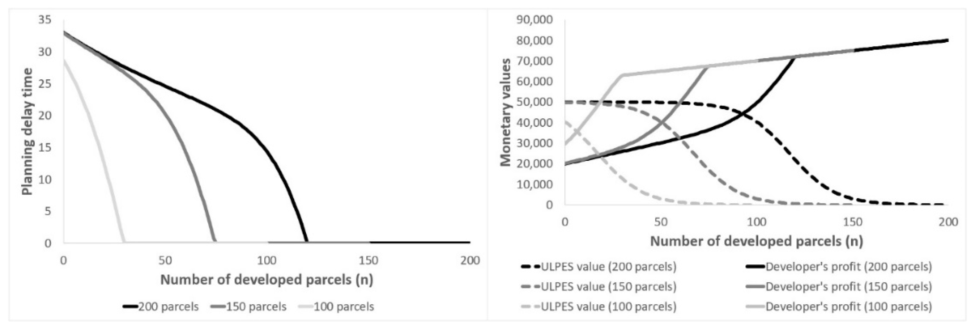
4.2. The Case of a Large Green Area

The following is a numerical simulation of the dynamics described by Equations (6) and (7), according to the imaginary scenario defined in Table 2 (the full simulation is included in the Supplementary Materials). For simplicity, we do not model two competing developers (as our focus is no longer on the outcomes for a single parcel but on the dynamics of the whole green area as additional parcels are developed over time). The game defined in the previous section, with all its associated details, is played when a new green parcel becomes a candidate for development. In this simulation, we show the outcomes of the game for a high-quality developer that manages to upgrade the parcels, increasing their social value even if the ULPES values disappear (see Figure 1 below).
Initially, the ULPES value provided by the whole undeveloped green area is almost maximal, while the purchasing price of a parcel is minimal. Therefore, the planning delay time is extremely long. Only an extremely stubborn developer will be willing to wait such a long planning delay time. It is precisely this characteristic that is the main factor keeping the green area from development and in its current state, probably for a long time. However, once a real-estate developer succeeds in developing the first parcel, it triggers a snowball effect: suddenly the green area does not appear immune to development. The land purchasing price of each remaining green parcel increases slightly, as does the willingness to pay of the developer’s potential clients. Since purchase prices are a bit higher, and the ULPES value of the whole area decreases slightly, the planner’s delay time is shortened. Every parcel of green land successfully developed accelerates the process, shortening the planning delay time for each subsequent parcel. Once the system approaches the more pronounced decreasing gradients of the ULPES value function (when n is approximately 90 in the simulation), large planning delay times are no longer justified, and soon the planner’s intervention itself is not justified. In the simulation, this happens when n = 121 . In all the remaining parcels, the developer can build his real-estate project overnight, and the ULPES values formerly provided by the area vanish. In order to test the robustness of the results with regards to changes in the parameters, we perform a sensitivity analysis of the of the planning delay time, the monetary values of the ULPES and the developer’s profit as a function of the initial number of undeveloped parcels. We use successive values of 200 (the baseline, as shown in Figure 1), 150 and 100 for the parameter N (the initial number of green parcels), assuming that E S 200 = 50,000 and that E S 150 and E S 100 behave according to Equation (6). The results are included in Figure 2.
A smaller undeveloped area, composed by less parcels, results in lower initial ULPES values and higher initial developer’s profits (Figure 2 Right). This is a consequence of the lower initial delay planning times, and results in a steeper decline of the delay functions when the number of developed parcels grows (black, gray and light-gray lines in Figure 2 Left). The processes depicted in Figure 2 have the same dynamics of the baseline in Figure 1, influenced by different initial conditions.

5. Discussion

Some assumptions in this study have been introduced for simplicity, but no significant difficulties arise if these are relaxed. For example, the assumption that the developer builds the project overnight once permission is received, and the revenues are collected instantaneously. Although in a realistic setup this is impossible, an additional building and marketing delay will not quantitively change the model’s results. This addition implies that a certain period of time is added to the exponent t in Equation (2). However, this additional time is different from the point of view of the developer. The planning delay time is imposed exogenously and is out of the developer’s control. In comparison, any additional building or marketing delay depends on the developer’s abilities and business skills.
A more serious limitation of the study is the assumption, also introduced for simplicity, that the planner has an accurate estimation of the ULPES values provided by the undeveloped parcel. This is clearly not true, since the best a planner can hope is to have an approximate guess. This situation implies two different risks: undervaluation or overvaluation of the ULPES values. If these are undervalued, a low-quality project can be approved even if it causes a loss of social welfare. On the contrary, if the ULPES value are overvalued, high-quality projects can be rejected even if they are worthy of development. In order to deal with both cases, a more complicated game setting is required. For example, an iterative game in which both players are allowed to learn from past experiences and update their current strategies. This type of evolutionary games can be a follow up of the current simple model.
Externalities are ubiquitous in land markets in general, particularly in urban areas [9,16]. One of the reasons urban planning exists is to deal with these externalities, and many very common and widely applied regulative instruments are specifically designed towards this objective. Urban planning regulations should, therefore, be feasible and quantifiable [9]. Whether justified or disputed, the rules of the game should be clear to all involved in the urban land market. However, planning delay times do not follow this mold. On one hand, the planning delay is a well know factor [12] that influences real-estate developers’ decisions [10,11]. On the other, since it is not known in advance, it is an informal tool perceived as a regulatory risk [13]. A possible interpretation of the planning delay times is that they are a consequence of bureaucratic opaqueness on the part of the planners. If this is the case, more transparent and precise regulations will result in a delay-free planning process [10]. Our interpretation is different: in our view, planning delay times are an integral part of the planning process and have an important function within it. Looking at the planning process as a continuous negotiation between regulators, society and developers, the role of planning delay times is to (attempt to) ensure that the social welfare in an urban area is not impaired as a consequence of development, particularly when land use conversions are involved. This said, why is this additional informal instrument needed in addition to formal and quantifiable regulations? The answer is found in the uncertainty associated with the potential loss of locally provided urban ecosystem services (ULPES), which are very difficult to define and valuate accurately. The informal regulation imposed by planning delay times is in fact an attempt by the planning agencies, together with the general public, to balance the loss of ULPES with worthwhile social gains.
The general public was introduced here since it is, at least in democratic societies, an integral part of the urban planning process [65]. Public involvement, in particular when expressed through lawsuits and appeals, is considered a significant factor in planning delay [66]. The game setting described in this paper assumes that the agent is a single entity (“the planner”), but this agent can also be conceptualized as a coalition of forces (including planning agencies, civil society, social groups, environmentalist organizations, and others influenced by or interested in the area under development). In addition, we assumed that “the planner” has an accurate assessment of the ULPES provided either by a single undeveloped parcel or a large green area. In reality, such assessment is not available, and only rough estimates may be defined. Moreover, the perception of potential ULPES loss may be different for different people according to place of residence, personal background and lifestyle. The simple game described in this paper is unable to take into these details account, but it provides a reasonable framework for reflection on the phenomenon of planning delay times and their role in the ongoing negotiation between real-estate developers and society over the value and utilities provided by urban land.

6. Conclusions

Accurate valuation ecosystem services in general, and locally provided urban ecosystem services (ULPES) in particular, are a troublesome issue. After more than two decades of intensive research efforts, the quantification and valuation of different types of ecosystem services are either questioned in principle [67] or are actively being discussed without an apparent convergence towards an agreed ground [68,69]. It is not surprising, thus, that a review of the recent scientific literature on the valuation of ecosystem services in urban areas found that most of the studies are based on diverse types of non-monetary valuations [70]. However, ecosystem services are real, in the sense that people obtain tangible benefits from their existence [71,72] and clearly perceive their loss when these are no longer provided [73]. As such, the urban planning system must take ULPES into account, assigning them concrete values [71], either explicitly or implicitly. We interpret that planning delay times are an attempt to implicitly assess the potential loss of ULPES expected when a real-estate project is developed converting former green land.
To summarize, the main hypothesis of this paper is that the planning delay is an informal tool that ensures social welfare in an urban area increases, including cases in which open spaces are developed. Since locally provided urban ecosystem services (ULPES) are hard to assess, it is difficult to compare their potential loss with the potential gains of a real-estate project. Planning delay times are an alternative tool that, by presenting financial losses to the real-estate developer, test whether the developer is willing to wait the imposed time. If the developer is stubborn enough, this is interpreted as a strong signal that the social welfare achieved through the project is larger than the loss of social welfare caused by the elimination of green space and its associated ecosystem services. Although the model was defined in simple, well-known and clear-cut terms, it offers an alternative explanation for planning delay times that appear fluid as a consequence of ongoing negotiations between developers, urban planners and the general public in the city.

Supplementary Materials

The following are available online at https://www.mdpi.com/2071-1050/12/15/5940/s1, Table S1: SI-Sustainability-PlanningDelayTime-Rev1-LargeGreenAreaSimulation.

Funding

This research was funded by the Israel Science Foundation, Grant Number 319/17.

Conflicts of Interest

The authors declare no conflict of interest.

Appendix A

Demonstration of the effective screening condition.
Proposition 1.
Assume that the interest rate ( r ) is fixed over time, and the following relation holds:
( W T P H I H ) > E S V a l > ( W T P L I L )
Then, the waiting time ( t ) represents a single crossing property for the developer’s project type.
Proof: 
The function ( 1 + r ) t is monotonically increasing t R . □
Therefore, functions W T P H I H ( 1 + r ) t and W T P L I L ( 1 + r ) t decrease monotonically t R .
Since t was defined as the time necessary to match c = E S V a l ( 1 + r ) t , and since (A1) holds, it follows that
W T P H I H ( 1 + r ) t > E S V a l ( 1 + r ) t > W T P L I L ( 1 + r ) t
In other words,
W T P H I H ( 1 + r ) t > c > W T P L I L ( 1 + r ) t W T P H I H ( 1 + r ) t c > 0 > W T P L I L ( 1 + r ) t c
Therefore, the present value of a project with waiting time t will be profitable for a high-valued project, whereas for a low-valued project it will not. As a result, the waiting time ( t ) fulfills the single crossing property’s requirement and is an effective screening policy for P.
If (A1) does not hold, there are two possible cases:
( W T P H I H ) > ( W T P L I L ) > E S V a l
Or
E S V a l > ( W T P H I H ) > ( W T P L I L )
In case (A4), the result is:
W T P H I H ( 1 + r ) t c > W T P L I L ( 1 + r ) t c > 0
Therefore, the present value of a project with waiting time t will be profitable both for a high-valued project and for a low-valued one. Under these conditions, the waiting time ( t ) does not fulfill the single crossing property’s requirement anymore.
In case (A5), the result is:
0 > W T P H I H ( 1 + r ) t c > W T P L I L ( 1 + r ) t c
In other words, the present value of a project with waiting time t will be unprofitable both for a high-valued project and for a low-valued one. Under these conditions, the waiting time ( t ) again does not fulfill the single crossing property’s requirement anymore.
Corollary 1.
  • If (A1) holds and P sets a waiting time t > 0 as defined previously, then the following separating equilibrium exists: a developer of type D H will develop the parcel, and a developer of type D L will do nothing. This follows immediately from the proposition that D H will not deviate because he will lose the opportunity to make a profit, and D L will not deviate either, since developing the parcel will result in net losses. Additionally, any type of pooling equilibrium is impossible due to the single crossing property and the fact that t is initially defined by the planner.
  • If ( W T P H I H ) > ( W T P L I L ) > E S V a l , the following pooling equilibrium emerges: both types of developers will seek to develop the parcel. D H will not deviate because he will lose the opportunity to make a profit, but the same holds for D L . Any imposed waiting time t will unnecessarily lower the social utility. Therefore, t = 0 .
  • If E S V a l > ( W T P H I H ) > ( W T P L I L ) , the following pooling equilibrium emerges: both types of developers will not be interested in the parcel’s development. Both D H and D L will incur net losses if they develop the parcel. They will not deviate from the do-nothing action because in so doing they will incur net losses. The planner will define t depending on E S V a l and c relations, but the outcome will be an undeveloped parcel and a planner payoff π P = E S V a l .
Summarizing, it was demonstrated that given ( W T P H I H ) > E S V a l > ( W T P L I L ) , if the agent (in this case P) defines a waiting time such as c = E S V a l ( 1 + r ) t , a separating equilibrium arises.

References

  1. Fu, P.; Weng, Q. A time series analysis of urbanization induced land use and land cover change and its impact on land surface temperature with Landsat imagery. Remote Sens. Environ. 2016, 175, 205–214. [Google Scholar] [CrossRef]
  2. Kabisch, N.; Strohbach, M.; Haase, D.; Kronenberg, J. Urban green space availability in European cities. Ecol. Indic. 2016, 70, 586–596. [Google Scholar] [CrossRef]
  3. Kabisch, N.; Qureshi, S.; Haase, D. Human–environment interactions in urban green spaces—A systematic review of contemporary issues and prospects for future research. Environ. Impact Assess. Rev. 2015, 50, 25–34. [Google Scholar] [CrossRef]
  4. Andersson, E.; Barthel, S.; Borgström, S.; Colding, J.; Elmqvist, T.; Folke, C.; Gren, Å. Reconnecting Cities to the Biosphere: Stewardship of Green Infrastructure and Urban Ecosystem Services. AMBIO 2014, 43, 445–453. [Google Scholar] [CrossRef] [Green Version]
  5. Elmqvist, T.; Fragkias, M.; Goodness, J.; Güneralp, B.; Marcotullio, P.J.; McDonald, R.I.; Parnell, S.; Schewenius, M.; Sendstad, M.; Seto, K.C.; et al. Urban Ecosystem Services. In Urbanization, Biodiversity and Ecosystem Services: Challenges and Opportunities; Elmqvist, T., Fragkias, M., Goodness, J., Güneralp, B., Marcotullio, P.J., McDonald, R.I., Parnell, S., Schewenius, M., Sendstad, M., Seto, K.C., Wilkinson, C., Eds.; Springer: Dordrecht, The Netherlands, 2013; pp. 175–251. [Google Scholar]
  6. Campbell, S. Green Cities, Growing Cities, Just Cities? Urban Planning and the Contradictions of Sustainable Development. J. Am. Plan. Assoc. 1996, 62, 296–312. [Google Scholar] [CrossRef]
  7. Aevermann, T.; Schmude, J. Quantification and monetary valuation of urban ecosystem services in Munich, Germany. Z. Wirtsch 2015, 59, 188–200. [Google Scholar] [CrossRef] [Green Version]
  8. Dowall, D.E. The Role and Function of Urban Land Markets in Market Economies. In Workshop on Privatization of Land in Ukraine; Ministry of Construction and Architecture, State Committee on Land Resources, United States Agency for International Development: Kiev, Ukraine, 1993; p. 15. [Google Scholar]
  9. Ortiz, A.; Bertaud, A. Land Markets and Urban Management: The Role of Planning Tools. In The Challenge of Urban Government: Policies and Practices; Maria, E.F., Richard, S., Eds.; The International Bank for Reconstruction and Development/The World Bank: Washington, DC, USA, 2001. [Google Scholar] [CrossRef] [Green Version]
  10. Rubin, Z.; Felsenstein, D. Is planning delay really a constraint in the provision of housing? Some evidence from Israel. Pap. Reg. Sci. 2019, 98, 2179–2200. [Google Scholar] [CrossRef]
  11. Czamanski, D.; Roth, R. Characteristic time, developers’ behavior and leapfrogging dynamics of high-rise buildings. Ann. Reg. Sci. 2011, 46, 101–118. [Google Scholar] [CrossRef]
  12. Ball, M. Planning Delay and the Responsiveness of English Housing Supply. Urban Stud. 2011, 48, 349–362. [Google Scholar] [CrossRef]
  13. Mayo, S.; Sheppard, S. Housing Supply and the Effects of Stochastic Development Control. J. Hous. Econ. 2001, 10, 109–128. [Google Scholar] [CrossRef] [Green Version]
  14. Broitman, D.; Czamanski, D. Cities in Competition, Characteristic Time, and Leapfrogging Developers. Environ. Plan. B Plan. Des. 2012, 39, 1105–1118. [Google Scholar] [CrossRef]
  15. Broitman, D.; Czamanski, D. Bursts and Avalanches: The Dynamics of Polycentric Urban Evolution. Environ. Plan. B Plan. Des. 2015, 42, 58–75. [Google Scholar] [CrossRef] [Green Version]
  16. Cheshire, P.C. Land market regulation: Market versus policy failures. J. Prop. Res. 2013, 30, 170–188. [Google Scholar] [CrossRef]
  17. Meijer, R.; Jonkman, A. Land-policy instruments for densification: The Dutch quest for control. Town Plan. Rev. 2020, 91, 239–258. [Google Scholar] [CrossRef]
  18. Brueckner, J.K.; Helsley, R.W. Sprawl and blight. J. Urban Econ. 2011, 69, 205–213. [Google Scholar] [CrossRef]
  19. Brueckner, J.K. Urban Sprawl: Diagnosis and Remedies. Int. Reg. Sci. Rev. 2000, 23, 160–171. [Google Scholar] [CrossRef]
  20. Duraiappah, A.K.; Naeem, S.; Agardy, T.; Ash, N.J.; Cooper, H.D.; Diaz, S.; Faith, D.P.; Mace, G.; McNeely, J.A.; Mooney, H.A.; et al. Ecosystems and Human Well-Being: Biodiversity Synthesis; a Report of the Millennium Ecosystem Assessment. Available online: https://experts.umn.edu/en/publications/ecosystems-and-human-well-being-biodiversity-synthesis-a-report-o (accessed on 11 June 2020).
  21. Steffen, W. Interdisciplinary research for managing ecosystem services. Proc. Natl. Acad. Sci. USA 2009, 106, 1301–1302. [Google Scholar] [CrossRef] [Green Version]
  22. Broitman, D.; Czamanski, D.; Malkinson, D. Cities and Nature. Int. Rev. Environ. Resour. Econ. 2018, 12, 47–83. [Google Scholar] [CrossRef]
  23. Andersson-Sköld, Y.; Klingberg, J.; Gunnarsson, B.; Cullinane, K.; Gustafsson, I.; Hedblom, M.; Knez, I.; Lindberg, F.; Sang, O.Å.; Pleijel, H.; et al. A framework for assessing urban greenery’s effects and valuing its ecosystem services. J. Environ. Manag. 2018, 205, 274–285. [Google Scholar] [CrossRef]
  24. Tzoulas, K.; Korpela, K.; Venn, S.; Kaz, V.Y. Promoting ecosystem and human health in urban areas using Green Infrastructure: A literature review. Landsc. Urban Plan. 2007, 81, 167–178. [Google Scholar] [CrossRef] [Green Version]
  25. Grahn, P.; Stigsdotter, U.A. Landscape planning and stress. Urban For. Urban Green. 2003, 2, 1–18. [Google Scholar] [CrossRef] [Green Version]
  26. Chang, C.-R.; Li, M.-H.; Chang, S.-D. A preliminary study on the local cool-island intensity of Taipei city parks. Landsc. Urban Plan. 2007, 80, 386–395. [Google Scholar] [CrossRef]
  27. Nowak, D.J.; Hirabayashi, S.; Bodine, A.; Greenfield, E. Tree and forest effects on air quality and human health in the United States. Environ. Pollut. 2014, 193, 119–129. [Google Scholar] [CrossRef] [PubMed] [Green Version]
  28. Derkzen, M.L.; van Teeffelen, A.J.A.; Verburg, P.H. REVIEW: Quantifying urban ecosystem services based on high-resolution data of urban green space: An assessment for Rotterdam, the Netherlands. J. Appl. Ecol. 2015, 52, 1020–1032. [Google Scholar] [CrossRef]
  29. Asabere, P.K.; Huffman, F.E. The Relative Impacts of Trails and Greenbelts on Home Price. J. Real Estate Financ. Econ. 2009, 38, 408–419. [Google Scholar] [CrossRef]
  30. Conway, D.; Li, C.Q.; Wolch, J.; Kahle, C.; Jerrett, M. A Spatial Autocorrelation Approach for Examining the Effects of Urban Greenspace on Residential Property Values. J. Real Estate Financ. Econ. 2010, 41, 150–169. [Google Scholar] [CrossRef]
  31. Gibbons, S.; Mourato, S.; Resende, G.M. The Amenity Value of English Nature: A Hedonic Price Approach. Environ. Resour. Econ. 2014, 57, 175–196. [Google Scholar] [CrossRef] [Green Version]
  32. Balzan, M.V.; Caruana, J.; Zammit, A. Assessing the capacity and flow of ecosystem services in multifunctional landscapes: Evidence of a rural-urban gradient in a Mediterranean small island state. Land Use Policy 2018, 75, 711–725. [Google Scholar] [CrossRef]
  33. Baró, F.; Gómez-Baggethun, E.; Haase, D. Ecosystem service bundles along the urban-rural gradient: Insights for landscape planning and management. Ecosyst. Serv. 2017, 24, 147–159. [Google Scholar] [CrossRef] [Green Version]
  34. Larondelle, N.; Haase, D. Urban ecosystem services assessment along a rural–urban gradient: A cross-analysis of European cities. Ecol. Indic. 2013, 29, 179–190. [Google Scholar] [CrossRef]
  35. Dierwechter, Y. The spaces that smart growth makes: Sustainability, segregation, and residential change across Greater Seattle. Urban Geogr. 2014, 35, 691–714. [Google Scholar] [CrossRef]
  36. Adams, D.; Tiesdell, S. Planners as Market Actors: Rethinking State–Market Relations in Land and Property. Plan. Theory Pract. 2010, 11, 187–207. [Google Scholar] [CrossRef]
  37. Healey, P. The Reorganisation of State and Market in Planning. Urban Stud. 1992, 29, 411–434. [Google Scholar] [CrossRef]
  38. Dierwechter, Y. Home: Residential Geographies of Contained (Re)ordering. In Urban Sustainability through Smart Growth: Intercurrence, Planning, and Geographies of Regional Development across Greater Seattle; Dierwechter, Y., Ed.; Springer International Publishing: Cham, Switzerland, 2017; pp. 143–178. [Google Scholar]
  39. Healey, P.; Williams, R. European Urban Planning Systems: Diversity and Convergence. Urban Stud. 1993, 30, 701–720. [Google Scholar] [CrossRef]
  40. van der Krabben, E.; Jacobs, H.M. Public land development as a strategic tool for redevelopment: Reflections on the Dutch experience. Land Use Policy 2013, 30, 774–783. [Google Scholar] [CrossRef]
  41. Gyourko, J.; Saiz, A.; Summers, A. A New Measure of the Local Regulatory Environment for Housing Markets: The Wharton Residential Land Use Regulatory Index. Urban Stud. 2008, 45, 693–729. [Google Scholar] [CrossRef] [Green Version]
  42. Quigley, J.M.; Rosenthal, L.A. The Effects of Land Use Regulation on the Price of Housing: What Do We Know? What Can We Learn? Cityscape 2005, 8, 69–137. [Google Scholar]
  43. Mayo, S.; Sheppard, S. Housing Supply under Rapid Economic Growth and Varying Regulatory Stringency: An International Comparison. J. Hous. Econ. 1996, 5, 274–289. [Google Scholar] [CrossRef]
  44. Needham, B.; Segeren, A.; Buitelaar, E. Institutions in Theories of Land Markets: Illustrated by the Dutch Market for Agricultural Land. Urban Stud. 2011, 48, 161–176. [Google Scholar] [CrossRef]
  45. Sorensen, A. Institutions and Urban Space: Land, Infrastructure, and Governance in the Production of Urban Property. Plan. Theory Pract. 2018, 19, 21–38. [Google Scholar] [CrossRef]
  46. Levy, S.; Martens, K. Negotiated Heights: An Agent-Based Model of Density in Residential Patterns. In Proceedings of the 13th International Conference on Computers in Urban Planning and Urban Management (CUPUM 2013), Utrecht, The Netherlands, 2–5 July 2013. [Google Scholar]
  47. Knaap, G.J.; Hopkins, L.D.; Donaghy, K.P. Do Plans Matter? A Game-Theoretic Model for Examining the Logic and Effects of Land Use Planning. J. Plan. Educ. Res. 1998, 18, 25–34. [Google Scholar] [CrossRef]
  48. Lai, S.K.; Ding, C.; Tsai, P.C.; Lan, I.C.; Xue, M.; Chiu, C.P.; Wang, L.G. A game-theoretic approach to urban land development in China. Environ. Plan. B Plan. Des. 2008, 35, 847–862. [Google Scholar] [CrossRef]
  49. Samsura, D.A.A.; van der Krabben, E.; van Deemen, A.M.A. A game theory approach to the analysis of land and property development processes. Land Use Policy 2010, 27, 564–578. [Google Scholar] [CrossRef]
  50. Kreps, D.M.; Sobel, J. Chapter 25 Signalling. In Handbook of Game Theory with Economic Applications; Elsevier: Amsterdam, The Netherlands, 1994; Volume 2, pp. 849–867. [Google Scholar]
  51. Spence, M. Job Market Signaling. Econ. Q. J. 1973, 87, 355. [Google Scholar] [CrossRef]
  52. Jensen, C.; Meckling, H. Theory of the Firm: Managerial Behavior, Agency Costs, and Ownership Structure; Springer: Dordrecht, The Netherlands, 1979; pp. 163–231. [Google Scholar]
  53. Gupta, K.; Kumar, P.; Pathan, S.K.; Sharma, K.P. Urban Neighborhood Green Index—A measure of green spaces in urban areas. Landsc. Urban Plan. 2012, 105, 325–335. [Google Scholar] [CrossRef]
  54. Baguette, M. The classical metapopulation theory and the real, natural world: A critical appraisal. Basic Appl. Ecol. 2004, 5, 213–224. [Google Scholar] [CrossRef]
  55. Pellet, J.; Fleishman, E.; Dobkin, D.S.; Gander, A.; Murphy, D.D. An empirical evaluation of the area and isolation paradigm of metapopulation dynamics. Biol. Conserv. 2007, 136, 483–495. [Google Scholar] [CrossRef]
  56. Kremen, C.; Williams, N.M.; Bugg, R.L.; Fay, J.P.; Thorp, R.W. The area requirements of an ecosystem service: Crop pollination by native bee communities in California: Area requirements for pollination services to crops. Ecol. Lett. 2004, 7, 1109–1119. [Google Scholar] [CrossRef]
  57. Barral, M.P.; Oscar, M.N. Land-use planning based on ecosystem service assessment: A case study in the Southeast Pampas of Argentina. Agric. Ecosyst. Environ. 2012, 154, 34–43. [Google Scholar] [CrossRef]
  58. Sugiyama, T.; Francis, J.; Middleton, N.J.; Owen, N.; Giles-Corti, B. Associations Between Recreational Walking and Attractiveness, Size, and Proximity of Neighborhood Open Spaces. Am. J. Public Health 2010, 100, 1752–1757. [Google Scholar] [CrossRef] [PubMed]
  59. Jaganmohan, M.; Knapp, S.; Buchmann, C.M.; Schwarz, N. The Bigger, the Better? The Influence of Urban Green Space Design on Cooling Effects for Residential Areas. J. Environ. Qual. 2016, 45, 134–145. [Google Scholar] [CrossRef] [PubMed]
  60. Czembrowski, P.; Kronenberg, J. Hedonic pricing and different urban green space types and sizes: Insights into the discussion on valuing ecosystem services. Landsc. Urban Plan. 2016, 146, 11–19. [Google Scholar] [CrossRef]
  61. Lutzenhiser, M.; Netusil, N.R. The Effect of Open Spaces on a Home’s Sale Price. Contemp. Econ. Policy 2001, 19, 291–298. [Google Scholar] [CrossRef]
  62. Barbier, E.B. A spatial model of coastal ecosystem services. Ecol. Econ. 2012, 78, 70–79. [Google Scholar] [CrossRef]
  63. Fang, C.; Bao, C.; Huang, J. Management Implications to Water Resources Constraint Force on Socio-economic System in Rapid Urbanization: A Case Study of the Hexi Corridor, NW China. Water Resour. Manag. 2007, 21, 1613–1633. [Google Scholar] [CrossRef] [Green Version]
  64. Mitchell, M.G.E.; Bennett, E.M.; Gonzalez, A. Strong and nonlinear effects of fragmentation on ecosystem service provision at multiple scales. Environ. Res. Lett. 2015, 10, 094014. [Google Scholar] [CrossRef]
  65. Damer, S.; Hague, C. Public Participation in Planning: A Review. Town Plan. Rev. 1971, 42, 217. [Google Scholar] [CrossRef]
  66. Macintosh, A.; Gibbons, P.; Jones, J.; Constable, A.; Wilkinson, D. Delays, stoppages and appeals: An empirical evaluation of the adverse impacts of environmental citizen suits in the New South Wales land and environment court. Environ. Impact Assess. Rev. 2018, 69, 94–103. [Google Scholar] [CrossRef]
  67. Silvertown, J. Have Ecosystem Services Been Oversold? Trends Ecol. Evol. 2015, 30, 641–648. [Google Scholar] [CrossRef] [Green Version]
  68. Cordier, M.; Agúndez, J.A.P.; Hecq, W.; Hamaide, B. A guiding framework for ecosystem services monetization in ecological–economic modeling. Ecosyst. Serv. 2014, 8, 86–96. [Google Scholar] [CrossRef] [Green Version]
  69. Venkatachalam, L. Environmental economics and ecological economics: Where they can converge? Ecol. Econ. 2007, 61, 550–558. [Google Scholar] [CrossRef]
  70. Atif, S.B. Identification of Key-Trends and Evaluation of Contemporary Research Regarding Urban Ecosystem Services: A Path towards Socio-Ecological Sustainability of Urban Areas. Appl. Ecol. Environ. Res. 2018, 16, 3545–3581. [Google Scholar] [CrossRef]
  71. Hansen, R.; Frantzeskaki, N.; McPhearson, T.; Rall, E.; Kabisch, N.; Kaczorowska, A.; Kain, J.H.; Artmann, M.; Pauleit, S. The uptake of the ecosystem services concept in planning discourses of European and American cities. Ecosyst. Serv. 2015, 12, 228–246. [Google Scholar] [CrossRef] [Green Version]
  72. Livesley, S.J.; McPherson, E.G.; Calfapietra, C. The Urban Forest and Ecosystem Services: Impacts on Urban Water, Heat, and Pollution Cycles at the Tree, Street, and City Scale. J. Environ. Qual. 2016, 45, 119–124. [Google Scholar] [CrossRef] [PubMed]
  73. McDonald, R.I.; Forman, R.T.T.; Kareiva, P. Open Space Loss and Land Inequality in United States’ Cities, 1990–2000. PLoS ONE 2010, 5, e9509. [Google Scholar] [CrossRef] [Green Version]
Figure 1. Simulation scenario of a large green area according to Table 2. The planning delay time is presented as a function of the number of developed parcels (left). The urban locally provided ecosystem services (ULPES) value provided by the whole area and the developer’s profit by developing a single parcel are presented as a function of the number of developed parcels (right).
Sustainability 12 05940 g001
Figure 2. Simulation scenario of a large green area according to Table 2 with different starting points: N = 200 , N = 150 and N = 100 . The planning delay time is presented as a function of the number of developed parcels (left). As in Figure 1, the ULPES value provided by the whole area and the developer’s profit from developing a single parcel is presented as a function of the number of developed parcels (right).
Sustainability 12 05940 g002
Table 1. Representing the payoffs of the planner, the high-quality developer and the low-quality developer, respectively.
π H π L π P
If D H develops the parcel π H = W T P H I H ( 1 + r ) t c π L = 0 π P = W T P H I H ( 1 + r ) t c E S V a l
If D L develops the parcel π H = 0 π L = W T P L I L ( 1 + r ) t c π P = W T P L I L ( 1 + r ) t c E S V a l
If the parcel is not developed π H = 0 π L = 0 π P = E S V a l
Table 2. Imaginary simulation scenario of a large green area.
ParameterValueMeaning
N 200The initial number of green parcels in the green area
E S N 50,000The maximal ULPES value provided by the green area
A 1000Parameter of the ULPES value logistical decay function
B 0.92Parameter of the ULPES value logistical decay function
r 0.05The rate of interest, assumed to be fixed
I 30,000The building costs incurred by the developer
W T P 100,000The initial willingness to pay for the real-estate project developed on a single parcel. Each new parcel converted increases its value by 200
c 10,000The initial purchasing price of a single parcel. Each new parcel converted increases its cost by 100

