Article

Identifying Spatial Relationships between Built Heritage Resources and Short-Term Rentals before the Covid-19 Pandemic: Exploratory Perspectives on Sustainability Issues

Department of Architecture and Design, Politecnico di Torino, 10125 Torino, Italy
*
Author to whom correspondence should be addressed.
Sustainability 2020, 12(11), 4533; https://doi.org/10.3390/su12114533
Submission received: 21 March 2020 / Revised: 27 May 2020 / Accepted: 29 May 2020 / Published: 3 June 2020

Abstract

:
Built heritage resources (BHRs) are multidimensional assets that need to be conceived under a sustainability and circular economy framework. Whereas it is essential that their conservation, management, and enjoyment are sustainable, it is also necessary that the environmental, cultural, and socio-economic contexts in which they are integrated are sustainable too. Like other amenities, BHRs can improve the quality of the urban environment and generate externalities; additionally, they may influence sectors such as real estate, hospitality, and tourism. In this framework, this contribution aims to identify spatial relationships occurring between BHRs and short-term rentals (STRs), i.e., a recent economic phenomenon facilitated by platforms such as Airbnb. Through the application of Exploratory Spatial Data Analysis techniques and taking Turin (Italy) as a case study, this article provides evidence that spatial correlation patterns between BHRs and STRs exist, and that the areas most affected by STRs are the residential neighborhoods located in the proximity of the historic center of the city. Relations with other sets of socio-economic variables are highlighted too, and conclusions suggest that future studies are essential not only to monitor sustainability issues and reflect on new housing models and sustainable uses of buildings, but also to understand the evolution of the phenomenon in light of the pandemic Covid-19.

1. Introduction

Built heritage resources can be considered as cultural, social, as well as economic assets. If their existence firstly depends on the intrinsic values that are attributed to them by individuals and communities [1,2,3], the current socio-economic conditions require that the maintenance, management, and use of these resources be performed in light of the multidimensional sustainability and circular economy frameworks [4,5,6,7,8,9,10,11]. This implies that actions regarding built heritage should pursue not only specific objectives (e.g., restoration, re-use, valorization, etc.) but also environmental, economic, cultural, and social sustainability. Overall, these dimensions should not be considered as separate, but rather as intertwined and sometimes even reciprocally influencing: For instance, retrofit interventions can in some cases facilitate environmental and economic sustainability [12,13], but also extend the life cycle and usability of the buildings, generally increasing their multidimensional and long-term value for society.
Given that monuments, historical buildings, and other architectural entities with cultural significance are usually not excludible, at least for their exterior components, and they are thus particularly likely to generate externalities [14,15], it is then also necessary to evaluate whether the socio-economic contexts directly or indirectly enabled by built heritage are overall sustainable. If, on the one hand, the presence of built heritage can function as a driver for the economy and particularly stimulate tourism [16], on the other one, it is known that over-tourism may lead to negative consequences, such as displacement of inhabitants, alteration of the social fabric, decrease of the quality of life of residents, loss of authenticity, and also damage to local resources [17,18,19,20]. These positive and negative phenomena are related to the role played by built heritage, especially in urban contexts: In fact, it has been widely acknowledged that built heritage resources frequently represent urban amenities able to contribute to the quality of the environment and to the appeal of an urban area [21]. Additionally, these resources may also have the power to attract other facilities such as restaurants, cafés, and shops, as well as high-skilled, high-income workers and professionals; possible consequences might be constituted by knowledge-led spillover effects [22], but also by social segregation problems [23,24] and increase of real estate prices [25].
With reference to the tourism sector, academics have pointed out that the location of built heritage resources and of urban amenities in general affects where hotels are positioned too [26]. Two traditional interpretative approaches are, for instance, the tourist-historic city model and mono-centric models. The former was developed with special regard to medium-sized Western European provincial towns, and it identifies proximity to the business district or to the historic city center as particularly appealing for both the offer and demand side [27]. The latter—in line with a traditional vision of “monocentrality”—describes the city in simplified terms, i.e., as formed by concentric rings, where distance from the city center determines values and land-use patterns. The theory underpinning this model is the bid rent theory, i.e., a geographic economic theory assuming that people compete for using the land close to the city center/to the central business district, since it is easily accessible, it presents a high density of potential customers, and thus results in being more profitable. In the case of hotels, it is assumed that customers (and especially tourists) are open to pay more for easy access to the city center, and that consequently, hotels prefer to locate near the center in order to obtain higher revenues. More articulated perspectives have then recognized that contemporary cities actually present multiple nodes: In this case too, built heritage resources may function as one of the points of attraction and influence hotel location [26]. However, it must be mentioned that a key role in determining hotel location is also played by the presence of public transports and of other facilities that enable a convenient mobility towards the city and throughout the city itself. In this perspective, areas that are well and easily connected with desired urban destinations (e.g., neighborhoods characterized by urban quality thanks to the presence of built heritage resources) may become desirable hospitality venues for urban tourists too.
With the spread of digitally-mediated peer-to-peer accommodation systems—such as the leading Airbnb (www.airbnb.com)—another accommodation domain that can be affected by the location of built heritage resources and urban amenities is the one of short-term rentals. Peer-to-peer online platforms have in fact facilitated the encounter of hosts (i.e., people willing to temporarily rent their real-estate property or sub-portions of the unit) and guests (i.e., people seeking a short-term accommodation in private houses), greatly contributing to the expansion of the short-term rental market [28,29]. News and academic contributions have recently highlighted that this exponential growth is leading to unsustainable phenomena: With reference to the European urban context, the situation in tourism capital cities such as Lisbon, Madrid, Barcelona, Amsterdam, Florence, Venice, and others is actually contributing to the pressure on historic city centers, fostering alteration of the local social fabric, displacement of residents, and stress on local resources [30,31,32,33,34,35,36,37,38].
In light of this framework, this piece of research aims to shed light on possible spatial relationships occurring between short-term rentals and built heritage resources, taking the city of Turin (Italy) as a case study. Through the elaboration of choropleth maps and the application of ESDA—Exploratory Spatial Data Analysis techniques [39], the study intends to interpret in both qualitative and mathematical terms the distribution of short-term rentals in Turin, making reference to a time frame prior to the spread of the Covid-19 pandemic; in this process, socio-economic variables and the presence of built heritage resources are taken into account. Overall, the goal of the study is to investigate whether patterns of spatial proximity between built heritage resources and short-term rentals also exist in a city that is not a tourism capital (such as Barcelona, Amsterdam, etc.) but that has actually started to affirm itself as a tourist destination since the 2006 Winter Olympic Games [40,41,42]. Results do not have relevance only for this specific reality, since they contribute to the overall debate on short-term rentals and sustainability. In fact, even though results stemming from the exploration and analysis of geographic data should be considered as descriptive of the specific area under study [43] (p. 336) and generalizations should thus not be made, the replication of the study in different study-areas could nonetheless help researchers find differences and similarities among cities, supporting them in the potential elaboration of more general principles and tendencies.
The rest of the article is structured in the following way. Section 2 provides greater insight on the literature exploring the location of Airbnb listings in relation to historic centers; additionally, it introduces the main characteristics of Turin (Italy), making brief reference to local built heritage resources, tourism trends, socio-economic characteristics, and real estate features. Section 3 describes materials and methods, paying particular attention to data sources, data processing, and Exploratory Spatial Data Analysis techniques. Section 4 illustrates and discusses the main results of the research. Section 5 presents final remarks, identifies the limits of the study, and suggests future steps of research, also in light of the pandemic Covid-19.

2. Background

2.1. Short-Term Rentals and Historic Centres

Airbnb is a digitally-enabled peer-to-peer accommodation system which facilitates the contact between hosts (i.e., people willing to temporarily rent their real-estate property or sub-portions of a housing unit) and guests (i.e., people seeking for a short-term accommodation in private houses). Since its rise in 2008, this service has experienced a tremendous growth [44]: According to official figures, in the first months of 2020, more than 7 million listings were present on the platform, with an average number of guests per night exceeding 2 million [45]. According to the same sources, listings are distributed over more than 220 countries and 100,000 cities worldwide [45]. Even though short-term rentals are found in different contexts (e.g., seaside areas, mountain and lake regions, etc.), it is possible to state that this phenomenon has greatly interested cities and urban realms in general. The reasons behind this spread are various and are related both to global and local socio-economic trends (e.g., new behavioral and consumption patterns, transformations concerning mobility, housing habits and real estate investments, new uses of the urban environment, etc.). Among the variety of factors that have facilitated the spread of this reality, it is possible to mention at least two of them. Firstly, the increase of short-term rentals in cities can be ascribed to the extensive growth of urban tourism: In fact, tourist flows have generally increased in recent years, and some studies focusing on Italian main tourist cities have highlighted that a positive relationship exists between the number of Airbnb listings in a given year and the number of tourists registered in the previous year [35]. Secondly, short-term rentals are more profitable for owners than long-term rentals [46,47,48,49], especially during peak seasons and given a minimum level of demand.
Given the interrelation of short-term rentals with the tourism, hospitality, real estate, and social domains, the Airbnb phenomenon has recently started to be analyzed by different perspectives, such as—for instance—competition with the more traditional hotel sector [50,51], influence on the rental and real estate markets [52,53,54], socio-economic issues [38,55], market segmentation and users’ profiling [56], guests’ preferences and opinions [57,58,59], and regulations and legal aspects [60,61]. In this framework, the analysis of listings’ location in tourism destinations is currently acquiring increasing importance. Even though peer-to-peer accommodation systems introduce themselves as sharing economy platforms favoring the discovery and the economic development of urban portions usually out of tourists’ most beaten tracks, recent empirical evidence concerning European tourism capitals suggests that these digital intermediaries may actually favor central areas, contributing to challenge the carrying capacity of these spots and to make permanent residency unaffordable and difficult. Some empirical examples have emerged throughout the years directly from the news. For instance, in Barcelona (Spain) residents have protested against the uncontrolled rise of tourists favored by digital platforms such as Airbnb [32]; in Venice (Italy), short-term rentals have been interpreted by residents as a phenomenon contributing to the touristification of the city, and the excessive tourist pressure has led to the banning of new accommodations in historic areas [32,33]; in Amsterdam (Netherlands), Airbnb and other platforms are bringing more and more tourists right into the central areas of its urban realm [37], and the spread of short-term rentals has recently induced the local Municipality to identify policies to limit the phenomenon, including the banning of buy-to-rent behaviors [30]. In general terms, location near the most central and/or attractive areas of the city can represent an important competitive advantage, since it is known that tourists prefer to stay in areas located at walking distance from the desired points of attraction [34,62]. As a consequence, the presence of Airbnb accommodation in residential areas conveniently located near historic centers could induce tourists to stay right in those zones, with possible consequences on local socio-economic sustainability.
Given this trend, the academic literature as well has recently started to investigate this reality, paying particular attention to the spatial distribution of accommodations. In London (UK), Airbnb listings have been mainly concentrated in central areas, even though their location can spread up to 16 Km [36]. In Paris (France)—where the largest amount of Airbnb listings can be found—short-term rentals interest a great part of the city, but scholars have nevertheless noted that they are particularly located in district 18 (Montmartre) and 11 (Nation) [63]. In qualitative terms, it can be added that both districts are positioned on the Rive Droite, they are characterized by different points of interest (e.g., Montmartre cemetery, Moulin Rouge, Place de la Bastille, historical churches…), and present among the highest population densities of the city. On the basis of maps reported for Madrid [31], short-term rentals seem to be present especially in areas located on a central North-South axis. Then, at least up to 2016, Berlin’s Airbnb listings were mainly located in inner-city neighborhoods [53]. High concentrations of short-term rentals either in central areas or in their immediate vicinity were found, for instance, also in Hamburg (Germany) [64], Warsaw (Poland) [65], Valencia (Spain) [55], and Florence (Italy) [35]. With reference to other Italian cities, a more scattered distribution emerged in Milan [35], whereas Rome presented a mixed model [35]. In Budapest (Hungary), short-term rentals were found in correspondence of areas characterized by tourist attractiveness and services [66]. Finally, a study focusing on Barcelona (Spain) analyzed the distribution of short-term rentals in relation with the location of points of interest favored by tourists; this last piece of research interestingly highlighted that Airbnb listings mainly followed a concentric scheme around the central hub of the city (i.e., Plaza de Cataluña) [34].
If discourses generally referring to historic and city centers have overall started to appear not only in the news but also in the academic literature, structured reflections specifically considering built heritage resources are nonetheless lacking. As a consequence, they will be specifically addressed in this study, with empirical reference to the city of Turin (Italy). As thoroughly described in Section 3, the methods adopted to perform the analyses will include ESDA techniques, coherently with the approaches experimented by other authors [31,34,67].

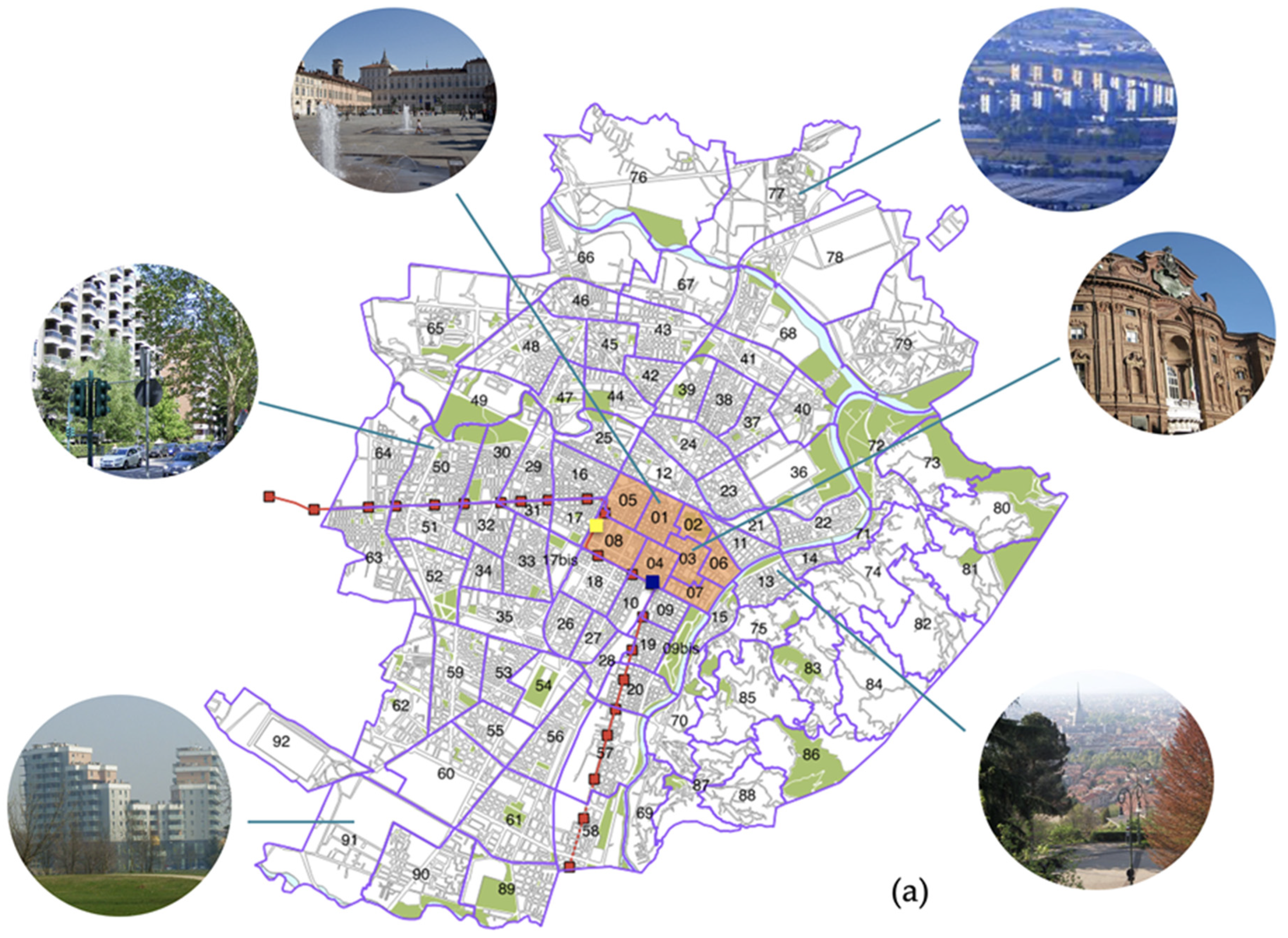
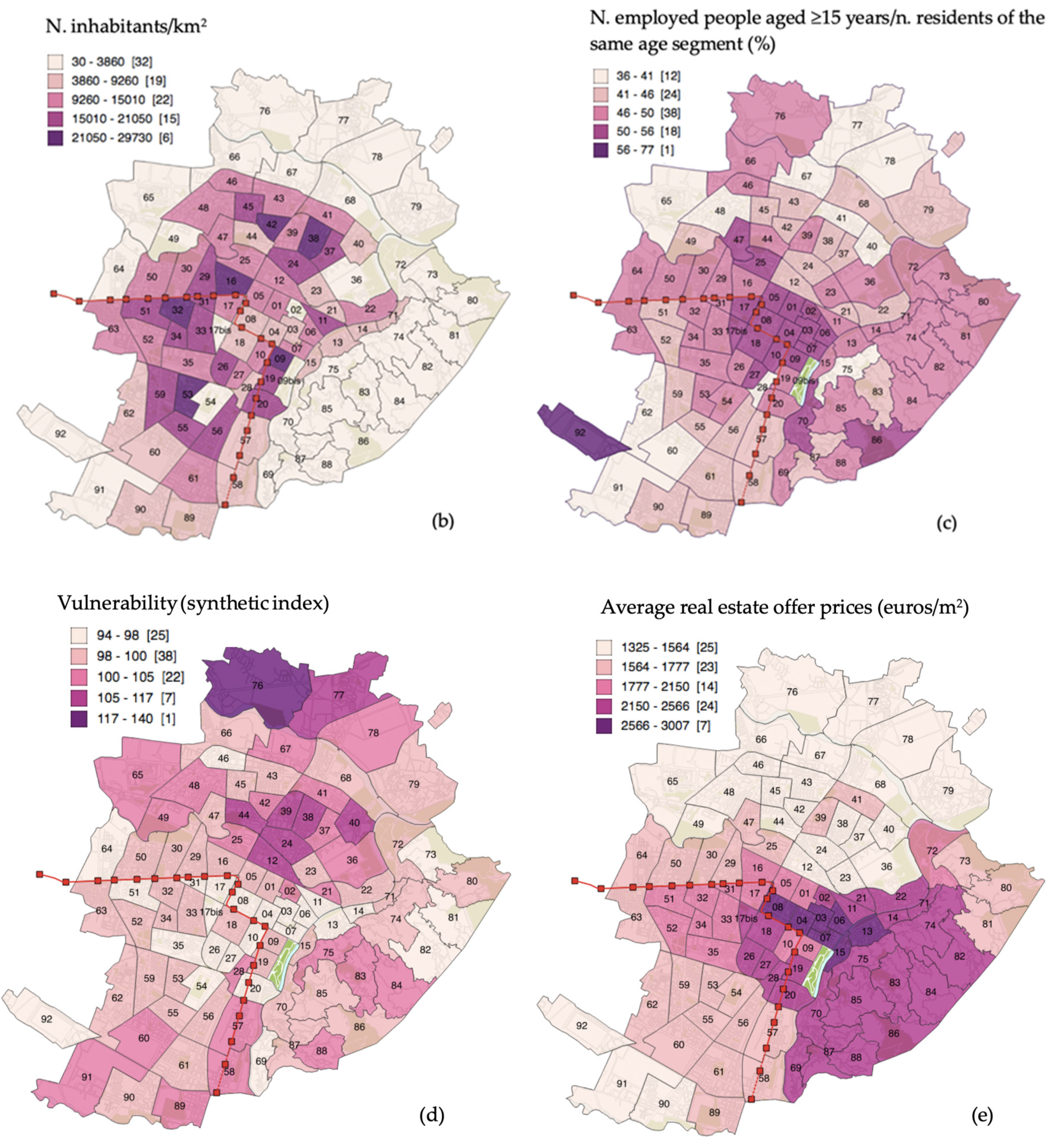
2.2. The City of Turin (Italy) As a Case-Study

Turin is a city located in the North-West of Italy, spreading over a surface of around 130 square kilometers [68] and counting—on 1st January 2018—a population of 882,523 inhabitants [69]. Once a typical one-company town related to the automotive sector, the city has started to significantly appear among tourist destinations since 2006, when it hosted the XX Winter Olympic Games [40,41,42]. Coherently with the general increased attractiveness of urban contexts and thanks to the restoration works, cultural initiatives, and infrastructure interventions that have taken place since the 2000s, the city has experienced a progressive growth in the number of tourists visiting it: For instance, the number of arrivals from 2002 to 2017 has more than doubled, shifting from 574,078 to 1,263,290 in 2017 [70]. Even though Turin is now trying to diversify its offer (e.g., through fairs, performing arts festivals, its wine and gastronomic scenery, and so on), museums, built heritage resources, and its contemporary art brand have greatly contributed to its allure so far. The built heritage of the city is varied, and it includes archaeological relics and ancient buildings dating back to Roman times, some Medieval and Renaissance remains, religious, civil and royal buildings belonging to the Baroque period (17th–18th centuries), as well as examples of modern and contemporary architecture. Relevant heritage sites and buildings are to some extent scattered throughout the city, but they are mostly concentrated in central areas. This is coherent with the extension of the CHUZ—Central Historic Urban Zone (ZUCS-Zona Urbana Centrale Storica in Italian) defined by the general regulatory plan of Turin and basically corresponding to the statistical zones (i.e., sub-portions of the city serving statistical purposes) numbers 01, 02, 03, 04, 05, 06, 07, and 08 (see Appendix A for the complete nomenclature of the 94 statistical zones existing in the city). Figure 1a outlines the extension of the CHUZ, making reference to relevant statistical zones (SZs). The CHUZ particularly includes the so called “Roman Quadrilateral”—i.e., the part of the city that was settled in Roman times and that presents a particularly intense continuity of life and settlement—the urban form mainly resulting from the interventions implemented in the Baroque period and some urban spaces defined in the 19th century. Overall, it is agreed that in the case of Turin, the value brought by architecture stems from the complexity of the historical process and consequently not only from the quality of the building types, but also from their variety [71] (p. 31). As pointed out by scholars, the present image of Turin is also due to the regulations progressively implemented by the Municipality, which—at least up to the 1930s—has fostered the development of a city with homogeneous characteristics, especially with regard to the shape and volumes of the buildings, the design of the façades, the building materials, and the colors and the decorations [71,72]. The contribution of architecture to the appeal of the city has been also confirmed by surveys [73]: In fact, visitors tend to visit Turin to generally explore the city and perform sightseeing, in line with what suggested by the literature on urban tourism [16].
In order to better contextualize the CHUZ, it must be mentioned that, at present, its attractiveness is increased by a high density of museums, shops, cafés, and restaurants. More specifically, the neighborhoods in the proximity of the “Roman Quadrilateral” have been interested by a gentrification process, and they are now one the favorite spots of the local nightlife scenery [74,75], as is the San Salvario area (SZ 09) [76]. As evidenced by the research group of the Polytechnic of Turin who is studying the relationships occurring between the local real estate market and the socio-economic characteristics of the city by the means of spatial statistics [77,78,79], these SZs are overall characterized by a certain degree of urban vibrancy, together with other SZs especially located in the central historical areas and along the route of the underground [79].
From a socio-economic perspective, central areas tend to be characterized by moderate population density values (also in light of the public nature of some buildings and open spaces existing in these zones), high employment rates, and high education levels [80]. The northern part is the most vulnerable from a socio-economic point of view: It shows the greatest incidence of foreign residents, it is characterized by lower education and employment levels, and it also manifests signs of vulnerability for what concerns the conditions of the building stock [77,78]. With specific reference to this one, it is possible to add that some of the northern and southern areas are still occupied by active or inactive industrial buildings, whereas the western and central zones are particularly devoted to residential and service functions. Coherently with urban stratification processes and the development of the city, the main construction period of the buildings located in central areas is antecedent to 1918, as clearly evidenced and mapped in other contributions [81]. Additionally, central zones present an extremely low percentage of buildings constructed during the building quantitative expansion of the 1950–1970s [77]; the highest percentages are found in some semi-peripherical and peripherical SZs located in the northern, southern, and western parts of the city instead, as highlighted and graphically mapped in articles specifically devoted to the topic [77]. Figure 1 shows the main characteristics of the areas; (a) illustrates the subdivision of the Municipality in 94 SZs, highlighting the CHUZ; (b), (c), (d), and (e) are choropleth maps elaborated on the basis of ISTAT data instead [80]. (b) represents population density, (c) employment rate, (d) the vulnerability index (all referred to the last national census, i.e., 2011), and (e) average real estate offer prices (updated to 2016).
Figure 1a also highlights the trajectory and stops of Turin’s underground, as well as the location of the two main railway stations of the city, i.e., Torino Porta Nuova (SZ 10) and Torino Porta Susa (SZ 08). The underground connects the center and the two main railway stations with the South and the West zones. Both Torino Porta Nuova and Torino Porta Susa are centrally located and can be considered as multifunctional transport hubs, with railway, underground, and urban and extra-urban bus lines conveying there. Additionally, they are located in the proximity of parking lots, taxi stops, and sharing mobility facilities. Last but not least, it must be mentioned that the complete re-design and renewal of Porta Susa occurred in recent years was performed to allow the transit and stop of high-speed trains, in the context of a major urban transformation that has significantly re-shaped the area.
Given that real estate prices are frequently recognized as a proxy for social, economic, environmental, and building quality, in light of Figure 1e, it is possible to state that the SZs more valued by the real estate market are the ones located in central areas (and well connected to the main transport hubs), followed by the upscale buildings and villas located in the panoramic eastern hillside. A sort of clear separation appears in correspondence of SZ 12-Borgo Dora-Valdocco, which hosts the biggest daily open-air market in Europe and presents a certain degree of multidimensional vulnerability: Starting from this SZ, northern areas overall manifest low average real estate offer prices. About this point, recent studies adopting a spatial statistics approach have found that indicators of vulnerability such as low education and presence of African and American population negatively affect average real estate offer prices [78]; negative effects on prices are exerted by the vulnerability of the housing stock too [77], whereas indicators of vibrancy (such as the cultural offer) usually positively affect the real estate market prices [79].
Figure 1. The city of Turin: (a) Subdivision into 94 Statistical Zones, with illustrative pictures of the city (the red line and squares represent the underground trajectory and stops, respectively; the blue square indicates the underground and railway station of Porta Nuova; the yellow square indicates the underground and railway station of Porta Susa; light orange areas refer to the extension of the CHUZ (Central Historic Urban Zone) instead); (b) population density; (c) employment rate; (d) vulnerability index; (e) average real estate offer prices. (b), (c), (d) and (e) visualize data according to the Jenks classification method. (Source: Authors’ elaboration on [80] and Geoportal of the Municipality of Turin data (http://geoportale.comune.torino.it/web/cartografia). (a) includes images licensed from Creative Commons 0 and free Wikipedia images).
Sustainability 12 04533 g001aSustainability 12 04533 g001b

3. Materials and Methods

3.1. Data Sources and Data Processing

In order to address the research objectives of the study, geo-referenced and spatial data were firstly collected from different sources. Geo-referenced data concerning Airbnb accommodations in Turin (years 2009–2017) were acquired from the private company Airdna (www.airdna.co), which provided data in csv format. Data were cleaned and filtered, and more than 3500 active listings were identified for the year 2017. Spatial data on Turin’s city borders, urban form, internal subdivisions, and characteristics were freely downloaded from the Geoportal of the Municipality of Turin (http://geoportale.comune.torino.it/web/cartografia) instead. The available open cartography was accessed both to provide a spatial context to Airbnb data and to perform descriptive, qualitative, and quantitative considerations. All relevant data were cleaned and then processed through QGis and GeoDa, i.e., two leading open software allowing for geo-based data analyses and visualization.
In order to perform analyses taking into account also the socio-economic dimension, official indexes and figures were retrieved from reports published by the Italian Statistical Institute in 2017 [80,82]. More specifically, these reports provide socio-economic information for each statistical zone (SZ) into which the Municipality of Turin is subdivided. As briefly mentioned in previous paragraphs, SZs are sub-municipal areas specifically outlined for statistical purposes, and they can be considered as morphologically, environmentally, and demographically more homogeneous than other types of territorial subdivisions [82].
For what concerns the identification of built heritage resources, it was decided to compile an ad hoc dataset able to integrate the experts’ point of view with a touristic one. For the purpose of this study, it was thus agreed to consider as built heritage resources the major points of interest (e.g., notable churches, royal residences, historical palaces of different ages, monuments, archaeological sites and relics, examples of modern and contemporary architecture, etc.) mentioned in two guides elaborated by distinguished experts in the architectural field [83,84]. The two guides were deemed particularly suitable as data sources since they were edited with the purpose of offering to both tourists and scholars a thorough description of the most significant buildings of Turin, taking into account different historical periods and providing information based on detailed historical research. Additionally, they also specify the full address of the buildings, thus allowing for geo-referencing and spatial analysis. The adoption of tourist guides as data sources was also made in light of the approaches followed by other authors. For instance, in their study about the influence of built heritage resources on real estate values of the Italian Veneto region, P. Rosato and colleagues adopted the Guida del Touring Club (i.e., one of the most authoritative tourist guides edited by Italian publishers) as a source [14]; more precisely, they considered the text length (i.e., number of rows) as a proxy for the importance of local built heritage resources.
Given that museums play an essential role in the local tourism landscape, it was deemed important to take into account their location too; in this case, relevant geo-located data were downloaded from the Geoportal of the Municipality of Turin.
All the identified spots were then inputted in the GIS database and treated as point features, being aware that considering other variables (e.g., surface occupied by historical buildings, linear meters of their façades, number of visitors attending the sites, etc.) or attributing different weights to environmental complexes could have added further depth to the analysis. However, given the exploratory nature of the study, it was deemed appropriate to start with the simplest approach, leaving some issues open for future research.

3.2. Spatial Analysis

Datasets were firstly combined and used to elaborate maps. Geo-referenced data concerning built heritage resources and Airbnb listings (i.e., point features) were first of all plotted on Turin’s cartography, as to visualize their absolute and relative location; then, choropleth maps (i.e., maps that describe the properties of distinct areas through colors, shades, etc.) [43] were elaborated with reference to the datasets mentioned above. Data and maps were initially investigated by the means of visual exploration; more precisely, visual exploration was carried out to perform qualitative and descriptive considerations about built heritage resources and Airbnb listings’ distribution. Then, a further step was represented by the conduction of spatial analysis.
In general terms, spatial analysis can be considered as “a set of methods whose results are not invariant under changes in the locations of the objects being analyzed” [43] (p. 291). Given the inductive and exploratory nature of the study, it was decided to particularly apply Exploratory Spatial Data Analysis (ESDA) techniques. Coherently with the objectives of the study, it was decided to perform spatial autocorrelation statistics, i.e., quantitative techniques used to analyze correlation relative to distance or connectivity relationships [85]. If, on the one hand, the existence of spatial autocorrelation may be integrated and corrected in regression models, on the other one, it can be considered as an approach bearing information in itself, given that it shows spatial associations existing among spatial entities [85].
Among the possible approaches, it was decided to calculate global, local, and bivariate Moran’s Indexes. More precisely, global statistics assess the presence and magnitude of spatial autocorrelation considering the entire study area, without indicating where specific patterns take place. One of the techniques most frequently used to assess spatial autocorrelation at the global level is the Global Moran’s Index (Global Moran’s I). It is calculated as follows:
I = N i = 1 n j = 1 n W i j ( X i X ¯ ) ( X j X ¯ ) ( i = 1 n j = 1 n W i j ) i = 1 n ( X i X ¯ ) 2
where I is the value of the Moran’s index; N is the number of spatial units; i and j are the locations of observations; Wij is the matrix of spatial weights; xi is the value of variable x registered for observation at location i; xj is the value of variable x registered for observation at location j; x ¯ is the mean of the values of the variable x. In short, Moran’s Index values can range between -1 and +1, with -1 indicating strong negative spatial autocorrelation (high values clustered with low values; low values clustered with high values), +1 strong spatial autocorrelation (high values clustered with high values, low values clustered with low values), and 0 no spatial autocorrelation (random distribution). Results stemming from the calculation of the Global Moran’s I are reported in a numeric form (index) and usually plotted on the so-called Moran’s scatterplot, a tool firstly developed and proposed to the academic community by scholar Luc Anselin in the 1990s [39]. As described by the author, the scatterplot is based on the interpretation of the Moran’s I as a regression coefficient in a bivariate linear regression of the spatially lagged variable (Wx) on the original variable [39] (p. 112). The scatterplot is constituted by an x axis and Wx axis, and from their intersection four quadrants are formed. The scatterplot is centered on 0,0 since the variables are taken as deviations from their means. The four quadrants in the scatterplot represent “different types of association between the value at a given location (xi) and its spatial lag, that is, the weighted average of the values in the surrounding locations (Wxi)” [39] (p. 117). The points displayed on the upper-right quadrant represent high values (above the mean) surrounded by high values (High-High), whereas the points existing in the lower-left quadrant represent low values (below the mean) surrounded by low values (Low-Low). The upper-left quadrant and lower-right quadrant are associated to low values surrounded by high values (Low-High) and high values surrounded by low values (High-Low), respectively, and they correspond to negative spatial association.
In order to identify the contribution of each individual observation to the global value of the indicator and identify spatial clusters, it was decided to also apply Local Indicator of Spatial Association (LISA) techniques [86]; more precisely, it was decided to calculate the local version of the Moran’s Index. In the case of local indicators of spatial association, interpretative tools usually include not only the Moran’s scatterplot and value, but also a map displaying High-High, Low-Low, Low-High, and High-Low patterns, if present. Additionally, another map displaying the significant levels of the identified relationships (i.e., 0.05, 0.01 and 0.001) helps the researcher better interpret the strength of results.
Finally, the Bivariate Moran’s I, which measures the correlation between the values of a variable x at a location i and the values of a different variable y in areas identified as near or as neighbors, was calculated too. Overall, all spatial analyses were performed through the GeoDa software: Resulting indexes, scatterplots, maps, and significance maps will be presented in the following section. Given the shape of the spatial units of analysis and the exploratory nature of the study, it was decided to perform the analysis on the basis of a polygon contiguity matrix (Queen type, first order), which is usually recommended for exploratory studies [43]. This type of matrix considers as neighbors of a target polygon the polygons sharing either an edge or corner with it.

4. Results and Discussion

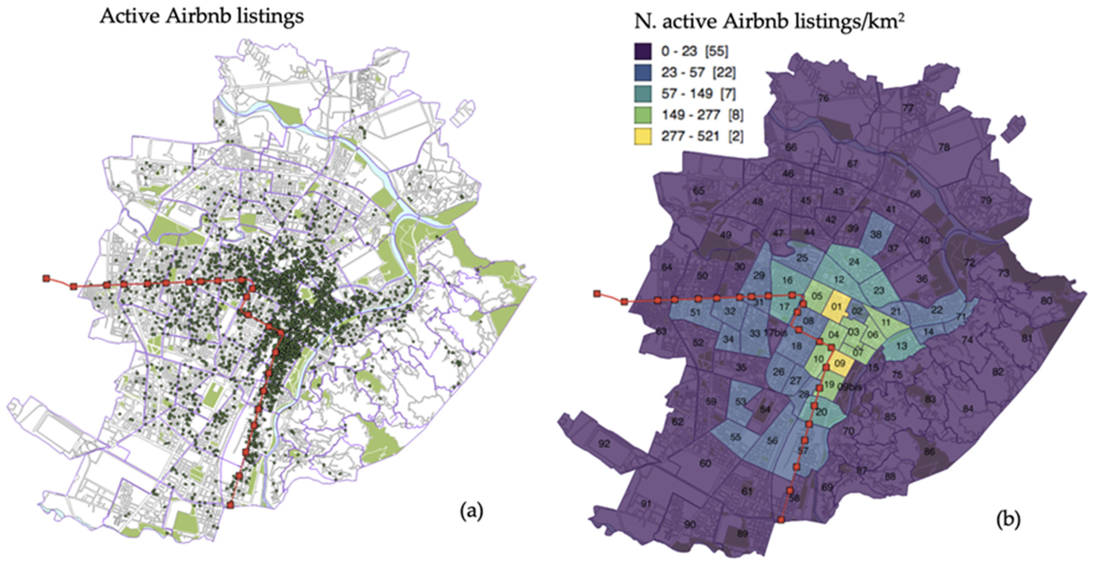
4.1. Short-Term Rentals Offer and Spatial Distribution

The number of Airbnb listings detected as active in November 2017 exceeded 3500 units; this amount included all the listing types made available on the platform (i.e., entire houses/apartments, private rooms, and shared rooms). As already reported in other articles [87,88], the vast majority of the listings included entire homes/apartments (72%), followed by private rooms (26.4%) and shared rooms (1.6%). With respect to other cities, the number of multi-listings hosts (i.e., management of more than one listing by a single host) resulted to be rather limited, suggesting that the phenomenon of professional hosts and of real estate agencies operating in the short-term rental sector was not particularly widespread [88]. Figure 2a shows the location of the listings with reference to Turin’s open cartography, whereas Figure 2b is a choropleth map that displays the number of listings/Km2 (density values) for each SZ. More specifically, the Jenks’ natural breaks classification method was followed, and data were then visualized coherently; this method optimizes the clustering of data, reducing the variance within classes and maximizing the variance between classes [89,90].
If Figure 2a suggests that short-term rentals do not equally interest the various zones of the city, Figure 2b helps understand that the SZs displaying the highest density of listings are the central 01-Municipio and 09-Piazza Madama Cristina (Borgo San Salvario), followed by 03-Palazzo Carignano, 04-Piazza San Carlo-Piazza Carlo Felice, 05-Piazza Statuto, 06-Piazza Vittorio Veneto, 07-Corso Cairoli-Piazza Bodoni, 10-Borgo San Secondo-Stazione Porta Nuova, 11-Borgo Vanchiglia, and 19-Piazza Nizza (Borgo San Salvario). As previously mentioned, the prevalent construction period of the buildings existing in these areas is prior to 1918 [81], and the studies performed by the research group working on Turin’s vulnerability and vibrancy [77,78,79] highlight that many of these SZs are also characterized by high levels of urban vibrancy [79], suggesting a possible relationship between the Airbnb phenomenon and the services offered by specific urban areas. The lowest values of density are registered especially in the peripheral and semi-peripheral northern, eastern, and southern areas instead; however, whereas density values abruptly decrease in the Eastern part (e.g., in SZ 15, 70, 75, etc., i.e., where hills and upscale residential villas/buildings are located), density values seem to decrease more gradually in the northern, southern, and especially western parts of the city. Overall, this Airbnb distribution is the result of an expansion process started in 2009: whereas in initial phases the few existing listings were widely distributed, from 2015 onwards short-term rentals were registered especially in central and semi-central areas (such as San Salvario, Vanchiglia, and the neighborhoods in the proximity of the “Roman Quadrilateral”); then, they progressively affected interstitial zones connecting these areas, as well as more peripheral zones and residential units located along the North–South axis of the underground [48].

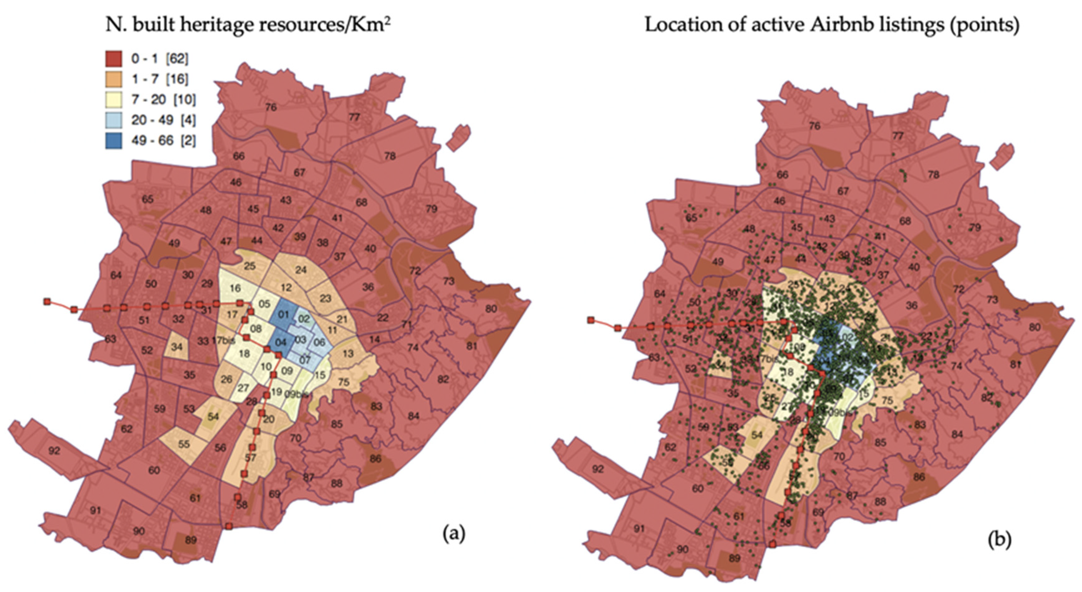
4.2. Built Heritage Resources

The density map elaborated for built heritage resources (number of built heritage points/Km2; Jenk’s classification) confirms that relevant points are especially concentrated in central SZs, namely 01-Municipio and 04-Piazza San Carlo-Piazza Carlo Felice, followed by 02-Palazzo Reale, 03-Palazzo Carignano, 06-Piazza Vittorio Veneto, and 07-Corso Cairoli-Piazza Bodoni (Figure 3a). In descriptive terms, it is thus possible to state that some SZs (e.g., 01, 03, 04, 06, and 07) are interested by a relatively high concentration of both short-term rentals and spots with historical and architectural value.
Figure 3b suggests in visual terms that in 2017, many Airbnb listings were located either in central historical zones or in their immediate proximity. In order to quantify and better specify these relationships—also in light of the socio-economic characteristics of the SZs—spatial statistics methods were then applied.

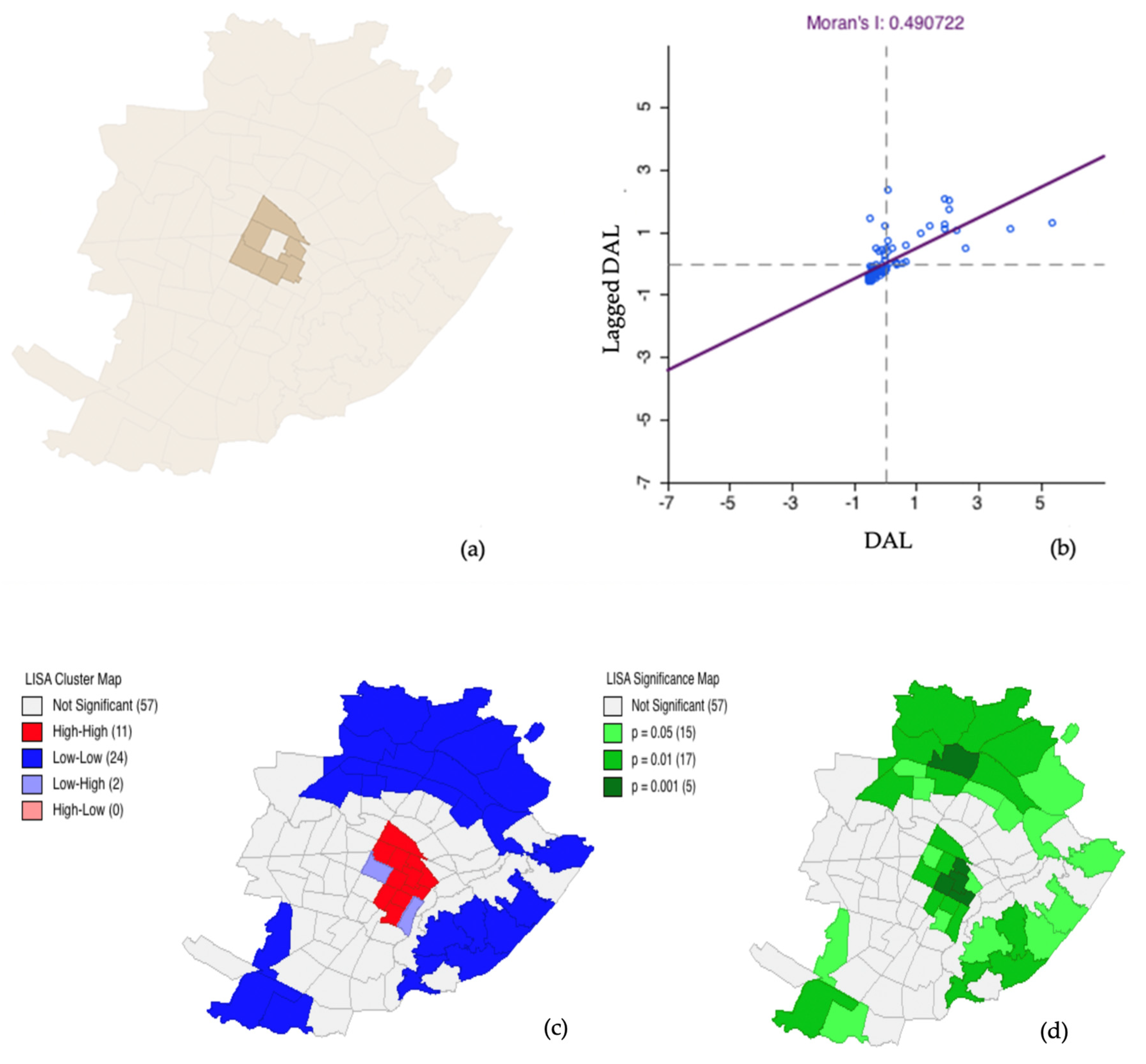
4.3. Spatial Statistics

The computation of the Global and Local Moran’s I for the density of Airbnb listings (DAL) and the density of built heritage resources (DBH) highlighted that both variables present positive spatial autocorrelation patterns. More precisely, results highlighted that the distribution of Airbnb listings is not random, but that a certain degree of spatial autocorrelation exists instead (Moran’s I: 0.491; pseudo p-value = 0.001). The LISA cluster map pointed out that particularly significant High-High spatial autocorrelation patterns (p = 0.001) exist for central areas such as SZ 02, 03, 04, and 07; even though characterized by a lower level of significance (p = 0.01 and p = 0.05), High-High patterns interest other central and semi-central statistical zones too (SZ 12, 05, 01, 06, 09, 19, and 10). Significant Low-Low patterns are registered for northern, southern, and eastern areas located towards the borders of the city, instead. As described in paragraph 2.2, the northern area is characterized by high levels of architectural and socio-economic vulnerability, the South presents industrial buildings, whereas the East is the hill zone of the city. Low-High patterns are evidenced for SZ 09bis-Valentino and SZ 08-Stazione Porta Susa, i.e., statistical zones that for their characteristics (park and railway station respectively) present low-density values of Airbnb listings, even though their neighboring zones manifest high density values (Figure 4). In the case of SZ 09bis-Valentino, neighboring zones with high density values are in fact San Salvario (SZ 09 and 19) and a SZ characterized by squares providing high environmental quality (SZ 07); in the case of SZ 08-Porta Susa, neighboring zones are the central, historical, and in some cases also vibrant 01-Municipio, 04-Piazza San Carlo-Piazza Carlo Felice, 05-Piazza Statuto, and 10-Borgo San Secondo-Stazione Porta Nuova.
The computation of the Global and Local Moran’s I for the density of built heritage resources (Figure 5) confirmed by a spatial statistic point of view what was suggested by choropleth maps and available cartography. In fact, results highlighted that spatial autocorrelation patterns exist (Moran’s I: 0.641; pseudo p-value = 0.001), and that High-High clusters interest central SZs.
In order to better understand the distribution of Airbnb listings in relation to the socio-economic characteristics of the SZs, the Bivariate Global Moran’s I values were computed. In this case, correlation coefficients were calculated considering the standardized values of the variable “density of Airbnb listings” (DAL) at a given location and the standardized values of a different variable in neighboring areas (spatially lagged variables). Given the objectives of the research, it was decided to include in the analyses the following variables: Density of built heritage resources (DBH), density of museums (DM), density of commercial activities (DCA), density of businesses devoted to food and beverage (DFBA). DBH for each SZ was calculated through personal data collection (PDC) as described in previous paragraphs, whereas DM, DCA, and DFBA were obtained considering open access data available on the Geoportal of the Municipality of Turin (GMT). About this point, it must be mentioned that since it is not easy to determine whether all the DCA and DFBA businesses are still active, DCA and FBA should not be considered as necessarily referring to the present commercial scenery, but rather as a proxy of the commercial and recreational vocation of the areas. Then, it was decided to include in the analyses also the following socio-economic variables: Population density (PD), incidence of foreigner residents (IFR), vulnerability index (VI), cultural operators’ index (CCOI), average offer prices (euros/square meter) of the real estate market (OPRE), real estate expansion index (REEI), building conservation index (BCI), level of education (EL), and employment rate (ER). The values for each variable and for each SZ were based on the last 2011 ISTAT census data (indicated as ISTAT in Table 1), with the exception of real estate values, which were updated to 2016 [80]. Table 1 (Table 1) presents a list of the variables considered and the results emerged from the analyses (Bivariate Moran’s I values).
Correlation coefficients indicate that positive spatial correlation patterns are either low or not present when considering DAL and spatially lagged variables such as population density (PD, Bivariate Moran’s I = 0.132), incidence of foreigner residents (IFR, Bivariate Moran’s I = 0.044), vulnerability index (VI, Bivariate Moran’s I = −0.118), real estate expansion index (REEI, Bivariate Moran’s I = −0.044), and building conservation index (BCI, Bivariate Moran’s I = 0.020). Low positive spatial correlation patterns emerge when considering the cultural operators’ index (CCOI, Bivariate Moran’s I = 0.263), the level of education index (EL, Bivariate Moran’s I = 0.242), and the occupation rate (ER, Bivariate Moran’s I = 0.313) instead. Interestingly, a higher Moran’s value (Bivariate Moran’s I = 0.437) is obtained when taking into account the average offer prices (euros/m2) of the real estate market (OPRE): This suggests that high densities of Airbnb listings are associated to SZs that present neighboring areas characterized by high real estate prices. As underlined by scholars, spatial association does not necessarily imply causality, since two variables may be associated either due to a causal relationship or to a hidden variable causing the association itself; however, it nevertheless provides evidence of possible causality, to be assessed in light of other evidence and/or theories [85]. In this case, it is thus neither possible nor recommendable to state that high real estate prices cause high densities of Airbnb listings or vice versa; however, it seems reasonable to affirm that high values of one variable are associated to high values of the other spatially lagged variable instead. Considering that real estate prices are frequently recognized as a proxy for the quality of the residential units but also of the local environment, it is possible to advance that the presence of conditions contributing to the quality of the areas (such as, for instance, transports, services, and so on) favors both high real estate prices and the emergence of Airbnb listings. Similar results were obtained considering also the density of museums (DM, Bivariate Moran’s I = 0.403), the commercial (DCA, Bivariate Moran’s I = 0.472), and recreational (DFBA, Bivariate Moran’s I = 0.453) vocation of the areas. Finally, it is worth-noting that the presence of positive spatial correlation patterns was detected especially when considering the density of Airbnb listings (DAL) and the spatially lagged density of built heritage resources (DBH): In fact, in this case the highest Bivariate Moran’s I was registered (Bivariate Moran’s I = 0.544). Figure 6 graphically presents the obtained values. The treatment of the results through permutation procedures (999 permutations tests) highlighted the level of significance of the obtained results (Table 1).
Overall, these results thus reinforce the hypothesis that the presence of built heritage resources—as well as the one of museums and some leisure services connotating urban tourism destinations—in Turin’s central statistical zones is associated with the development of short-term rentals in neighboring SZs. In this perspective, the case of SZ 12-Borgo Dora-Valdocco seems particularly worth mentioning: In fact, as evidenced by the maps presented throughout the article, this SZ is located immediately North of the SZs with the highest concentration of built heritage resources, and it presents a considerable density of Airbnb listings too. Even though the environmental quality of the area still manifests some criticalities (as reflected by the values of its vulnerability index and by its low average real estate offer prices), it seems that its spatial proximity to one of the most historical and attractive areas of the city facilitates the emergence of short-term rentals. As suggested in other contributions [48], it is actually possible to advance that the particular combination of its location and of its environmental characteristics makes SZ 12 less desirable for permanent residency while especially suitable and profitable for short-term rentals. In fact, whereas a critical quality of the urban environment may mine permanent residency, the same characteristics may be tolerated for short stays (especially considering that SZ 12 is at walking distance from the main tourist area) and even perceived as contributing to the authenticity of the experience. Finally, given that in this SZ long-term rental rates are low too, short-term rentals emerge as a more profitable solution, in the presence of a certain level of tourism demand [48].

5. Conclusions and Steps for Future Research

This study provided evidence that spatial relationships and spatial correlation patterns between the density of built heritage resources and Airbnb listings exist in an urban tourism destination such as Turin (Italy). Additionally, the study highlighted that the areas most affected by the new short-term rental reality are the residential neighborhoods located in the proximity of the historic center of the city, as already described for some European major urban tourism destinations. Overall, these results underline that both Airbnb listings and built heritage resources mainly insist on central areas, thus making the monitoring of the phenomenon beneficial to prevent the possible alteration of their social character and excessive pressure. About this point, the construction of a specific indicator of “socio-environmental pressure” could be particularly envisioned for the future: In fact, such an indicator would allow for not only the recording and evaluation of the overall effects engendered by short-term rentals, but also to express in a synthetic and comparable form new sustainability issues fostered by evolving digital tools and socio-economic frameworks.
Present results could then be further enriched through spatial analyses that include variables such as pedestrian areas and parks, transports, and other urban amenities and services; in fact, this would permit the investigation into what extent the distribution of short-term rentals is related not only to the historical built environment, but also to general centrality patterns. Additionally, the attribution of different weights to environmental complexes and the adoption of different criteria to identify and weigh built heritage resources could add further depth to the analysis.
This piece of work has also highlighted in a descriptive way that the buildings located in the areas most affected by short-term rentals seem to mainly date back to a historical period prior to 1918. Future steps of research could focus on the systematic identification and analysis of the characteristics of the buildings and of the residential units interested by the short-term rental phenomenon; more particularly, information of the following types could be collected: Construction period and style of the buildings; historicity (or not) of the building; availability of an elevator; floor at which the residential unit is located; square meters of the residential unit; occurrence (or not) of recent refurbishments/retrofit interventions, and so on. Even though it would be feasible to collect these information only for a sample of Turin’s Airbnb listings, and even though the research would be extremely challenging—since it would be necessary to capture details through approaches such as text and image analysis—this step of research would have the potential to clarify: (a) Which are the characteristics and construction periods of the buildings/residential units interested by short-term rentals; (b) whether (and to what extent) residential units located in historical buildings are currently used as venues for short-term rentals; (c) whether (and to what extent) short-term rentals are stimulating renovation and retrofit interventions, i.e., operations that allow for making residential units more appealing for guests and more economically advantageous for hosts. Given that short-term rentals are profitable only in the presence of a certain level of demand, this kind of research would overall help understand how the attractiveness of the city (including its built heritage resources) is currently influencing the life cycle (and cycle of use) of the local housing stock; moreover, it would also contribute to understand to what extent the short-term rental phenomenon is affecting the development of new housing models and a sustainable use of buildings. Appraisals on the overall sustainability of the interventions should be performed considering the economic, the environmental, as well as the social dimension (e.g., alteration of the social fabric, socio-economic conditions of the individuals affected by the short-term rental dynamic, etc.). In this framework, the effects of the short-term rental market on the traditional rental and real estate markets should be investigated too. Then, even though the phenomenon of multi-listings hosts and of professional real estate buyers has been relatively limited in Turin up to now, special attention should be paid to the identity of the subjects investing in short-term rental operations and promoting certain kinds of interventions. In fact, if on the one hand investments performed by professional real estate actors could foster interventions that are sustainable by an environmental point of view (e.g., implementation of energy retrofits), on the other one it is known that the action of these subjects frequently facilitate inhabitants’ displacement, gentrification, alteration of the social fabric, and phenomena of social inequality, thus compromising the overall sustainability of the projects. As a consequence, future studies should try to integrate further variables and dimensions, as to assess the overall and multidimensional sustainability of the short-term rental reality.
Finally, once relevant and appropriate data will be available, future studies will have to focus on the evolution of the short-term rental phenomenon after the spread of the Covid-19 pandemic. Given that the number of Airbnb listings is usually related to the number of tourists visiting a destination, it will be necessary to investigate whether and to what extent the short-term rental market will be affected by the decrease of mobility patterns and of tourist flows foreseen by experts for the near future, especially in big cities. In fact, with lower levels of demand, short-term rentals will become less profitable for hosts, and it is possible that lower revenues will induce them to convert the residential units into lodgings to be rented for long-term (or at least medium-term) periods. This conversion into long-term rentals would also lead to important consequences on the demand/offer ratio, and consequently on the yearly or monthly leases requested for long-term rentals. Even though it is likely that the short-term rental sector will be highly affected by the crisis, it must be mentioned that temporary rents are a sub-sector of the hospitality scenery that has nonetheless a greater potential of reconversion, if compared to other hospitality solutions such as hotels. While monitoring and even forecasting, special attention should be paid to the spatial dimension too: In fact, it would be interesting to check whether a possible contraction in the number of Airbnb listings will follow the inverse central-periphery spatial trend registered during the expansion phase or whether it will follow other logics. Last but not least, the need to maintain social distancing and to avoid gatherings might influence the destinations that will be favored by tourists (e.g., mountains and countryside rather than crowded city centers): As a consequence, the adoption of a perspective embracing not only the urban and intra-urban realms, but also the metropolitan and especially regional dimension could help better understand the effects of the Covid-19 pandemic on tourism and hospitality, also in light of multidimensional sustainability issues.

Author Contributions

All authors contributed equally to the final version of the article. Individual contributions can be identified as follows. Conceptualization, I.R., C.C., and R.C.; methodology, I.R., C.C., and R.C.; data curation, I.R.; formal analysis, I.R. and C.C.; writing I.R., C.C. and R.C.; supervision, C.C. and R.C. All authors have read and agreed to the published version of the manuscript.

Funding

This research received no external funding.

Acknowledgments

We would like to express our gratitude to OICT—Osservatorio Immobiliare della Città di Torino (Turin Real Estate Market Observatory) and particularly to architects Diana Rolando and Alice Barreca for their valuable support throughout the different phases of the research.

Conflicts of Interest

The authors declare no conflict of interest.

Appendix A

Table A1. The 94 statistical zones of Turin: Code number and nomenclature.
SZNameSZNameSZName
01Municipio31Boringhieri63Venchi Unica
02Palazzo Reale32Borgata Cenisia64Aeronautica-Pellerina
03Palazzo Carignano-
Vecchio Ospedale (Borgo Nuovo)
33Borgo San Paolo65Vallette-Saffarona-Villa Cristina
04Piazza San Carlo-Piazza Carlo Felice34Borgata Monginevro66Stradale di Lanzo
05Piazza Statuto35Polo Nord67Basse di Stura-Nuovo Poligono
06Piazza Vittorio Veneto36Cimitero Generale-
Scalo Vanchiglia
68Barriera di Stura-Istituto Rebaudengo
07Corso Cairoli-Piazza Bodoni
(Borgo Nuovo)
37Borgata Maddalene69Fioccardo-Alberoni
08Comandi Militari-
Stazione Porta Susa
38Borgata Monterosa70Pilonetto
09Piazza Madama Cristina
(Borgo San Salvario)
39Borgata Montebianco71Madonna del Pilone
9bisParco del Valentino40Regio Parco72Borgata Sassi-Meisino
10Borgo San Secondo-Stazione Porta Nuova41Nuova Barriera di Milano73Strada di Soperga
11Borgo Vanchiglia42Borgata Vittoria74Barriera di Chieri-Valpiana
12Borgo Dora-Valdocco43La Fossata75Villa della Regina-Val Salice
13Borgo Po- Parco Michelotti44Officine Savigliano-
Acciaierie Fiat
76Villaretto
14Motovelodromo45Madonna di Campagna77Falchera
15Borgo Crimea-
Monte dei Cappuccini
46Nuova barriera di Lanzo78Villaggio Snia
16Borgo San Donato47Borgata Ceronda79Barca-Bertolla-Abbadia di Stura
17Mercato del Bestiame-
Aiuola Martini
48Borgata Lucento80Soperga
17bisCarceri-Officine Ferroviarie49Parco Mario Carrara-Istituto Bonafous81Mongreno
18Vecchia Piazza d’Armi50Borgata Parella-Lionetto82Reaglie-Forni e Goffi
19Piazza Nizza (Borgo San Salvario)51Pozzo Strada83Santa Margherita
20Corso Dante-Ponte Isabella52Parco Francesco Ruffini-Borgata Lesna84Strada di Pecetto-Eremo
21Gasometro53Santa Rita da Cascia85San Vito–Val Salice
22Vanchiglietta54Stadio Comunale86Parco della Rimembranza
23Borgo Rossini55Ospizio di Carità87Cavoretto-Val Pattonera
24Borgata Aurora56Mercato Ortofrutticolo88Tetti Gramaglia-Strada dei Ronchi
25Piazzale Umbria-Scalo Valdocco57Molinette-Vecchia Fiat-Stazione89Ex Aeroporto di Mirafiori
26Crocetta58Millefonti-Nuova Barriera di Nizza90Mirafiori-Città Giardino
27Ospedale Mauriziano59Barriera di Orbassano91Drosso-Fornaci
28Borgo San Giorgio60Nuova Fiat92Tre Tetti-Bellezia
29Borgata Campidoglio-Martinetto61Lingotto-Ex Ippodromo
30La Tesoriera-Martinetto62Sanatorio-Gerbido
Source: [80].

References

  1. Cerreta, M.; Inglese, P.; Malangone, V.; Panaro, S. Complex values-based approach for multidimensional evaluation of landscape. In Proceedings of the International Conference on Computational Science and Its Applications, Guimarães, Portugal, 30 June–3 July 2014; Springer: Cham, Switzerland, 2014; pp. 382–397. [Google Scholar]
  2. Snowball, J.D. The economic, social and cultural impact of cultural heritage: Methods and examples. In Handbook on the Economics of Cultural Heritage; Rizzo, I., Mignosa, A., Eds.; Edward Elgar Publishing: Cheltenham, UK; Northampton, MA, USA, 2013; pp. 438–455. [Google Scholar]
  3. Throsby, C.D. Economics and Culture; Reprint; Cambridge University Press: Cambridge, UK, 2001; ISBN 0-521-58639-9. [Google Scholar]
  4. Coscia, C.; Russo, V. The Valorization of Economic Assets and Social Capacities of the Historic Farmhouse System in Peri-Urban Allocation: A Sample of Application of the Corporate Social Responsible (CSR) Approach. In Smart and Sustainable Planning for Cities and Regions; Bisello, A., Vettorato, D., Laconte, P., Costa, S., Eds.; Springer International Publishing: Cham, Switzerland, 2018; pp. 615–634. ISBN 978-3-319-75773-5. [Google Scholar]
  5. Coscia, C.; Lazzari, G.; Rubino, I. Values, Memory, and the Role of Exploratory Methods for Policy-Design Processes and the Sustainable Redevelopment of Waterfront Contexts: The Case of Officine Piaggio (Italy). Sustainability 2018, 10, 2989. [Google Scholar] [CrossRef] [Green Version]
  6. Coscia, C.; Fregonara, E.; Rolando, D. Project management, briefing and territorial planning. The case of military properties disposal. TERRITORIO 2015, 135–144. [Google Scholar] [CrossRef]
  7. Cinieri, V.; Zamperini, E. Lifecycle oriented approach for sustainable preservation of historical built heritage. In Online Proceedings of the international conference Built Heritage 2013—Monitoring Conservation Management; Boriani, M., Gabaglio, R., Gulotta, D., Eds.; Politecnico di Milano: Milan, Italy, 2013; pp. 465–471. [Google Scholar]
  8. Fusco Girard, L.; Gravagnuolo, A. Circular economy and cultural heritage/landscape regeneration. Circular business, financing and governance models for a competitive Europe. Bdc. Boll. Del Cent. Calza Bini 2017, 17, 35–52. [Google Scholar]
  9. Foster, G. Circular economy strategies for adaptive reuse of cultural heritage buildings to reduce environmental impacts. Resour. Conserv. Recycl. 2020, 152, 104507. [Google Scholar] [CrossRef]
  10. Morkunaite, Z.; Podvezko, V.; Zavadskas, E.K.; Bausys, R. Contractor selection for renovation of cultural heritage buildings by PROMETHEE method. Arch. Civil. Mech. Eng. 2019, 19, 1056–1071. [Google Scholar] [CrossRef]
  11. Morkunaite, Z.; Podvezko, V. Criteria Evaluation for Contractor Selection in Cultural Heritage Projects Using Multiple Criteria Approach. In Proceedings of the 17th International Colloquium on Sustainable Decisions in Built Environment, Vilnius, Lithuania, 15 May 2019. [Google Scholar]
  12. Fregonara, E.; Lo Verso, V.R.M.; Lisa, M.; Callegari, G. Retrofit Scenarios and Economic Sustainability. A Case-study in the Italian Context. Energy Procedia 2017, 111, 245–255. [Google Scholar] [CrossRef] [Green Version]
  13. Becchio, C.; Ferrando, D.G.; Fregonara, E.; Milani, N.; Quercia, C.; Serra, V. The cost-optimal methodology for the energy retrofit of an ex-industrial building located in Northern Italy. Energy Build. 2016, 127, 590–602. [Google Scholar] [CrossRef]
  14. Rosato, P.; Rotaris, L.; Breil, M.; Zanatta, V. Do We care about Built Cultural Heritage? The Empirical Evidence Based on the Veneto House Market; Fondazione Eni Enrico Mattei: Milan, Italy, 2008. [Google Scholar]
  15. Manganelli, B. Valutazioni economico-estimative nella valorizzazione di edifici storico-architettonici. Aestimum 2007, 51, 21–42. [Google Scholar]
  16. Ashworth, G.; Page, S.J. Urban tourism research: Recent progress and current paradoxes. Tour. Manag. 2011, 32, 1–15. [Google Scholar] [CrossRef]
  17. De Caro, S. Sviluppo del turismo e protezione del patrimonio culturale: Una sfida per il Ventunesimo secolo. In Città Storiche e Turismo Culturale: Città D’arte o Città di Cultura? Marketing Urbano o Turismo Culturale; Colletta, T., Ed.; Giannini: Napoli, Italy, 2013; ISBN 978-88-7431-662-5. [Google Scholar]
  18. Fusco Girard, L. L’economia della conservazione nel marketing urbano ed il turismo sostenibile nelle città storiche. In Città Storiche e Turismo Culturale: Città D’arte o Città di Cultura? Marketing Urbano o Turismo Culturale; Colletta, T., Ed.; Giannini: Napoli, Italy, 2013; ISBN 978-88-7431-662-5. [Google Scholar]
  19. Colletta, T. Città storiche e turismo culturale. L’innovazione tecnologica del sapere urbano e l’informazione-promozione turistico-culturale. In Città Storiche e Turismo Culturale: Città D’arte o Città di Cultura? Marketing Urbano o Turismo Culturale; Colletta, T., Ed.; Giannini: Napoli, Italy, 2013; ISBN 978-88-7431-662-5. [Google Scholar]
  20. Akin, N. Istanbul: Patrimoine Mondial et ses Problèmes de réservation dans le cadre du Tourisme Culturel. In Città Storiche e Turismo Culturale: Città D’arte o Città di Cultura? Marketing Urbano o Turismo Culturale; Colletta, T., Ed.; Giannini: Napoli, Italy, 2013; ISBN 978-88-7431-662-5. [Google Scholar]
  21. Glaeser, E.L.; Kolko, J.; Saiz, A. Consumer City. J. Econ. Geogr. 2001, 1, 27–50. [Google Scholar] [CrossRef]
  22. Koster, H.R.A.; Rouwendal, J. Historic Amenities and Housing Externalities: Evidence from the Netherlands; Tinbergen Institute: Amsterdam, The Netherlands, 2015. [Google Scholar]
  23. Koster, H.R.A.; Van Ommeren, J.; Rietveld, P. Historic Amenities, Income and Sorting of Households; Vrije Universiteit Amsterdam—Spatial Econometrics research Centre: Amsterdam, The Netherlands, 2013. [Google Scholar]
  24. Rypkema, D. Heritage Conservation and Property Values. In The Economics of Uniqueness: Investing in Historic City Cores and Cultural Heritage Assets for Sustainable Development; Licciardi, G., Amirtahmasebi, R., World Bank, Eds.; The urban development series; The World Bank: Washington, DC, USA, 2012; pp. 107–142. ISBN 978-0-8213-9650-6. [Google Scholar]
  25. Nijkamp, P. Economic Valuation of Cultural Heritage. In The Economics of Uniqueness: Investing in Historic City Cores and Cultural Heritage Assets for Sustainable Development; Licciardi, G., Amirtahmasebi, R., World Bank, Eds.; The World Bank: Washington, DC, USA, 2012; pp. 75–106. [Google Scholar]
  26. Yang, Y.; Luo, H.; Law, R. Theoretical, empirical, and operational models in hotel location research. Int. J. Hosp. Manag. 2014, 36, 209–220. [Google Scholar] [CrossRef]
  27. Ashworth, G.J.; Tunbridge, J.E. The tourist-historic city: Retrospect and prospect of managing the heritage city. In Advances in Tourism Research Series, 1st ed.; Pergamon: Amsterdam, NY, USA, 2000; ISBN 0-08-043675-7. [Google Scholar]
  28. Guttentag, D. Airbnb: Disruptive innovation and the rise of an informal tourism accommodation sector. Curr. Issues Tour. 2015, 18, 1192–1217. [Google Scholar] [CrossRef]
  29. Varma, A.; Jukic, N.; Pestek, A.; Shultz, C.J.; Nestorov, S. Airbnb: Exciting innovation or passing fad? Tour. Manag. Perspect. 2016, 20, 228–237. [Google Scholar] [CrossRef]
  30. Boztas, S. Buyer be-ware: Amsterdam seeks to ban buy-to-let on newbuild homes. The Guardian. 2019. Available online: https://www.theguardian.com/world/2019/mar/18/buyer-beware-amsterdam-seeks-to-ban-buy-to-let-on-newbuild-homes (accessed on 1 February 2020).
  31. Garcia-Ayllon, S. Urban Transformations as an Indicator of Unsustainability in the P2P Mass Tourism Phenomenon: The Airbnb Case in Spain through Three Case Studies. Sustainability 2018, 10, 2933. [Google Scholar] [CrossRef] [Green Version]
  32. Coldwell, W. First Venice and Barcelona: Now anti-tourism marches spread across Europe. The Guardian. 2017. Available online: https://www.theguardian.com/travel/2017/aug/10/anti-tourism-marches-spread-across-europe-venice-barcelona (accessed on 10 January 2020).
  33. Edwards, C. Venice wants to ban new hotels from opening in its historic centre. The Local. 2017. Available online: https://www.thelocal.it/20170602/venice-ban-new-hotels-bandb-from-opening-in-historic-centre-travel-tourism (accessed on 10 January 2020).
  34. Gutiérrez, J.; García-Palomares, J.C.; Romanillos, G.; Salas-Olmedo, M.H. The eruption of Airbnb in tourist cities: Comparing spatial patterns of hotels and peer-to-peer accommodation in Barcelona. Tour. Manag. 2017, 62, 278–291. [Google Scholar] [CrossRef] [Green Version]
  35. Picascia, S.; Romano, A.; Teobaldi, M. The airification of cities: Making sense of the impact of peer to peer short term letting on urban functions and economy. In Proceedings of the Annual Congress of the Association of European Schools of Planning, Lisbon, Portugal, 11–14 July 2017. [Google Scholar]
  36. Quattrone, G.; Proserpio, D.; Quercia, D.; Capra, L.; Musolesi, M. Who Benefits from the “Sharing” Economy of Airbnb; ACM Press: New York, NY, USA, 2016; pp. 1385–1394. [Google Scholar]
  37. Ven der Zee, R. The “Airbnb effect”: Is it real, and what is it doing to a city like Amsterdam? The Guardian. 2016. Available online: https://www.theguardian.com/cities/2016/oct/06/the-airbnb-effect-amsterdam-fairbnb-property-prices-communities (accessed on 15 January 2020).
  38. Cocola-Gant, A.; Gago, A. Airbnb, buy-to-let investment and tourism-driven displacement: A case study in Lisbon. Environ. Plan. A Econ. Space 2019. [Google Scholar] [CrossRef] [Green Version]
  39. Anselin, L. The Moran Scatterplot as an ESDA Tool to Assess Local Instability in Spatial Association. In Spatial Analytical Perspectives on GIS; Fischer, M., Scholten, H., Unwin, D., Eds.; Taylor & Francis: London, UK, 1996; pp. 111–125. [Google Scholar]
  40. Vanolo, A. The image of the creative city: Some reflections on urban branding in Turin. Cities 2008, 25, 370–382. [Google Scholar] [CrossRef]
  41. Vanolo, A. The image of the creative city, eight years later: Turin, urban branding and the economic crisis taboo. Cities 2015, 46, 1–7. [Google Scholar] [CrossRef]
  42. Vanolo, A. The Fordist city and the creative city: Evolution and resilience in Turin, Italy. CityCult. Soc. 2015, 6, 69–74. [Google Scholar] [CrossRef]
  43. Longley, P.A.; Goodchild, M.F.; Maguire, D.J.; Rhind, D.W. (Eds.) Geographic Information Science & Systems, 4th ed.; Wiley: New York, NY, USA, 2015. [Google Scholar]
  44. Ke, Q. Sharing Means Renting? An Entire-marketplace Analysis of Airbnb. In Proceedings of the 2017 ACM on Web Science Conference—WebSci ’17, Troy, NY, USA, 25–28 June 2017; ACM Press: Troy, NY, USA, 2017; pp. 131–139. [Google Scholar]
  45. Airbnb. Fast Facts. 2020. Available online: https://news.airbnb.com/fast-facts/ (accessed on 10 January 2020).
  46. Sdino, L.; Magoni, S. The Sharing Economy and Real Estate Market: The Phenomenon of Shared Houses. In Smart and Sustainable Planning for Cities and Regions; Bisello, A., Vettorato, D., Laconte, P., Costa, S., Eds.; Springer International Publishing: Cham, Switzerland, 2018; pp. 241–251. [Google Scholar]
  47. Wachsmuth, D.; Weisler, A. Airbnb and the rent gap: Gentrification through the sharing economy. Environ. Plan. A 2018, 50, 1147–1170. [Google Scholar] [CrossRef]
  48. Rubino, I. Short-term rentals and transformations in urban areas: The case of Turin (Italy). Territ. Ital. 2018, 1, 91–109. [Google Scholar]
  49. Mermet, A.C. Airbnb and Tourism Gentrification: Critical Insights from the Exploratory Analysis of the ‘Airbnb Syndrome’ in Reykjavík. In Tourism and Gentrification in Contemporary Cities; Gravari-Barbas, M., Guinand, S., Eds.; Routledge: London, UK, 2017; pp. 52–74. [Google Scholar]
  50. Blal, I.; Singal, M.; Templin, J. Airbnb’s effect on hotel sales growth. Int. J. Hosp. Manag. 2018, 73, 85–92. [Google Scholar] [CrossRef]
  51. Chen, Y.; Xie, K. Consumer valuation of Airbnb listings: A hedonic pricing approach. Int. J. Contemp. Hosp. Manag. 2017, 29, 2405–2424. [Google Scholar] [CrossRef]
  52. Gurran, N.; Phibbs, P. When Tourists Move In: How Should Urban Planners Respond to Airbnb? J. Am. Plan. Assoc. 2017, 83, 80–92. [Google Scholar] [CrossRef] [Green Version]
  53. Schäfer, P.; Braun, N. Misuse through short-term rentals on the Berlin housing market. Int. J. Hous. Mark. Anal. 2016, 9, 287–311. [Google Scholar] [CrossRef]
  54. Horn, K.; Merante, M. Is home sharing driving up rents? Evidence from Airbnb in Boston. J. Hous. Econ. 2017, 38, 14–24. [Google Scholar] [CrossRef]
  55. del Romero Renau, L. Touristification, Sharing Economies and the New Geography of Urban Conflicts. Urban. Sci. 2018, 2, 104. [Google Scholar] [CrossRef] [Green Version]
  56. Guttentag, D. Airbnb: Why Tourists Choose It and How They Use It. Available online: https://www.dg-research.com/Papers/Summary%20doc%20-%20Airbnb.pdf (accessed on 2 June 2020).
  57. Mody, M.; Suess, C.; Dogru, T. Comparing apples and oranges? Examining the impacts of Airbnb on hotel performance in Boston. Boston Hosp. Rev. 2017, 5, 1–15. [Google Scholar]
  58. Cheng, M.; Jin, X. What do Airbnb users care about? An analysis of online review comments. Int. J. Hosp. Manag. 2019, 76, 58–70. [Google Scholar] [CrossRef]
  59. Guo, Y.; Wang, Y.; Wang, C. Exploring the Salient Attributes of Short-Term Rental Experience: An Analysis of Online Reviews from Chinese Guests. Sustainability 2019, 11, 4290. [Google Scholar] [CrossRef] [Green Version]
  60. Atelier Parisien d’Urbanisme. Comparison of Regulatory Action Taken in Barcelona, New York and Paris. In Short-Term Rentals: An Analysis of Metropolitan Public Responses; Atelier Parisien d’Urbanisme: Paris, France, 2018. [Google Scholar]
  61. Prayag, G.; Ozanne, L.K. A systematic review of peer-to-peer (P2P) accommodation sharing research from 2010 to 2016: Progress and prospects from the multi-level perspective. J. Hosp. Mark. Manag. 2018, 27, 649–678. [Google Scholar] [CrossRef]
  62. Arbel, A.; Pizam, A. Some determinants of urban hotel location: The tourists’ inclinations. J. Travel Res. 1977, 15, 18–22. [Google Scholar] [CrossRef]
  63. Heo, C.Y.; Blal, I.; Choi, M. What is happening in Paris? Airbnb, hotels, and the Parisian market: A case study. Tour. Manag. 2019, 70, 78–88. [Google Scholar] [CrossRef]
  64. Brauckmann, S. City tourism and the sharing economy—potential effects of online peer-to-peer marketplaces on urban property markets. J. Tour. Futures 2017, 3, 114–126. [Google Scholar] [CrossRef] [Green Version]
  65. Gyódi, K. Airbnb and the Hotel Industry in Warsaw: An Example of the Sharing Economy? Cent. Eur. Econ. J. 2018, 2, 23–34. [Google Scholar] [CrossRef] [Green Version]
  66. Dudás, G.; Boros, L.; Kovalcsik, T.; Kovalcsik, B. The visualization of the spatiality of Airbnb in Budapest using 3-band raster representation. Geogr. Tech. 2017, 12, 23–30. [Google Scholar] [CrossRef]
  67. Adamiak, C.; Szyda, B.; Dubownik, A.; García-Álvarez, D. Airbnb Offer in Spain—Spatial Analysis of the Pattern and Determinants of Its Distribution. Isprs Int. J. Geo-Inf. 2019, 8, 155. [Google Scholar] [CrossRef] [Green Version]
  68. Urban Center Metropolitano. La Città e i Suoi Numeri; Urban Center Metropolitano: Torino, Italy, 2016; Available online: http://www.urbancenter.to.it/wp-content/uploads/2016/05/La-citta%CC%80-e-i-suoi-numeri.pdf (accessed on 24 June 2019).
  69. ISTAT. Popolazione Residente al Primo Gennaio 2018. Available online: http://dati.istat.it/Index.aspx?DataSetCode=DCIS_POPRES1 (accessed on 20 June 2019).
  70. Osservatorio Turistico Regionale del Piemonte. Dati Turistici Suddivisi per Comune-Anno 2017; Regione Piemonte: Torino, Italy, 2018; Available online: http://www.piemonte-turismo.it/wp-content/files/Scheda_-_pagg_55_COMUNI_-_MOVIMENTI_2017.pdf (accessed on 30 June 2019).
  71. Comoli, V.; Viglino, M. Architettura e città: Valori storici—Gli insediamenti storici. In Qualità e Valori Della Struttura Storica di Torino; Comoli, V., Viglino, M., Eds.; Quaderni del Piano Regolatore Generale di Torino; Città di Torino: Torino, Italy, 1992; pp. 31–58. [Google Scholar]
  72. Lupo, G. Tipi edilizi e normativa- Tipologia edilizia e morfologia urbana. In Qualità e Valori Della Struttura Storica di Torino; Comoli, V., Viglino, M., Eds.; Quaderni del Piano Regolatore Generale di Torino; Città di Torino: Torino, Italy, 1992; pp. 59–60. [Google Scholar]
  73. Regione Piemonte. Destinazione Torino. Una Meta Turistica che Conquista i Visitatori. 2010. Available online: http://www.ontit.it/opencms/export/sites/default/ont/it/riservativip/files/DestinazioneTorino.pdf (accessed on 10 October 2019).
  74. Curto, R.; Brondino, G.; Coscia, C.; Fregonara, E.; Grella, S. Dinamiche di mercato e gentrification a Torino. In Rigenerazione Urbana e Ricambio Sociale. Gentrification in Atto nei Quartieri Storici Italiani; Diappi, L., Ed.; Franco Angeli: Milano, Italy, 2009; pp. 43–79. [Google Scholar]
  75. Curto, R.; Brondino, G.; Coscia, C.; Fregonara, E.; Grella, S. Dinamiche di mercato, mobilità abitativa e gentrification: Una lettura attraverso i modelli di statistica multivariata e spaziale. In Rigenerazione Urbana e Ricambio Sociale. Gentrification in atto nei Quartieri Storici Italiani; Diappi, L., Ed.; Franco Angeli: Milano, Italy, 2009; pp. 163–187. [Google Scholar]
  76. Semi, G. Gentrification: Tutte le città come Disneyland; Il Mulino: Bologna, Italy, 2015. [Google Scholar]
  77. Barreca, A.; Curto, R.; Rolando, D. Housing Vulnerability and Property Prices: Spatial Analyses in the Turin Real Estate Market. Sustainability 2018, 10, 3068. [Google Scholar] [CrossRef] [Green Version]
  78. Barreca, A.; Curto, R.; Rolando, D. Assessing Social and Territorial Vulnerability on Real Estate Submarkets. Buildings 2017, 7, 94. [Google Scholar] [CrossRef] [Green Version]
  79. Barreca, A.; Curto, R.; Rolando, D. Urban Vibrancy: An Emerging Factor that Spatially Influences the Real Estate Market. Sustainability 2020, 12, 346. [Google Scholar] [CrossRef] [Green Version]
  80. ISTAT. Commissione Parlamentare di Inchiesta Sulle Condizioni di Sicurezza e Sullo Stato di Degrado Delle Città e Delle Loro Periferie—Cartogrammi del Comune di Torino; ISTAT: Roma, Italy, 2017. [Google Scholar]
  81. Barreca, A.; Curto, R.; Rolando, D. Location and real estate values: A study for the segmentation of the Microzones of Turin. Territ. Ital. 2017, 1, 49–71. [Google Scholar]
  82. ISTAT. Commissione Parlamentare di Inchiesta Sulle Condizioni di Sicurezza e Sullo Stato di Degrado Delle Città e Delle Loro Periferie—Nota Metodologica; ISTAT: Roma, Italy, 2017. [Google Scholar]
  83. Comoli, V.; Olmo, C. (Eds.) Torino. Guida di Architettura; Allemandi: Torino, Italy, 1999. [Google Scholar]
  84. Società degli Ingegneri e degli Architetti di Torino. 26, Ventisei Itinerari Di Architettura a Torino/architectural Walks in Turin; Società degli ingegneri e degli architetti: Torino, Italy, 2003; ISBN 88-88078-00-2. [Google Scholar]
  85. Miller, H.J. Tobler’s First Law and Spatial Analysis. Ann. Assoc. Am. Geogr. 2004, 94, 284–289. [Google Scholar] [CrossRef]
  86. Anselin, L. Local Indicators of Spatial Association-LISA. Geogr. Anal. 1995, 27, 93–115. [Google Scholar] [CrossRef]
  87. Rubino, I.; Coscia, C. Airbnb Revenue Generation in the Urban Context: An Analysis of Renting Patterns and Dynamics. In New Metropolitan Perspectives; Calabrò, F., Della Spina, L., Bevilacqua, C., Eds.; Springer International Publishing: Cham, Switzerland, 2019; Volume 100, pp. 643–651. ISBN 978-3-319-92098-6. [Google Scholar]
  88. Federalberghi Sommerso Turistico e Affitti Brevi; Edizioni ISTA: Roma, Italy, 2016; Available online: http://intranet.federalberghi.it:8000/pubblicazioni/Pub/Sommerso%20turistico%20e%20affitti%20brevi/sommerso%20turistico%20ed%20affitti%20brevi.pdf (accessed on 20 July 2019).
  89. Jenks, G.F. The data model concept in statistical mapping. Int. Yearb. Cartogr. 1967, 7, 186–190. [Google Scholar]
  90. Jiang, B. Head/Tail Breaks: A New Classification Scheme for Data with a Heavy-Tailed Distribution. Prof. Geogr. 2013, 65, 482–494. [Google Scholar] [CrossRef]
Figure 2. Distribution (a) and number of active listings/Km2 (b) in Turin (2017). (Source: Authors’ elaboration on data collected by the company Airdna).
Sustainability 12 04533 g002
Figure 3. Built heritage resources and Airbnb listings: Density map of listings of historical and architectural value (a); active 2017 Airbnb listings plotted on built heritage resources density map (b) (Source: Authors’ elaboration on Airdna and self-collected data).
Sustainability 12 04533 g003
Figure 4. Density of active Airbnb listings (November 2017): Queen first order connectivity map (a), Moran’s scatterplot and Moran’s I value (b), LISA (Local Indicator of Spatial Association) Cluster Map (c), and LISA Significance map (d). (Source: Authors’ elaboration).
Sustainability 12 04533 g004
Figure 5. Density of built heritage resources: Moran’s scatterplot and Moran’s I value (a), LISA Cluster Map (b), and LISA Significance map (c). (Source: Authors’ elaboration).
Sustainability 12 04533 g005
Figure 6. Bivariate Global and Local Moran’s I (DAL and DBH): Moran’s scatterplot (a), permutation test (b), BiLISA Cluster Map (c), and BiLISA Significance map (d). (Source: Authors’ elaboration).
Sustainability 12 04533 g006
Table 1. Short-term rentals and socio-economic variables: Bivariate Moran’s I values.
VariableSpatially Lagged VariableDefinitionData SourceBivariate Moran’s IPseudo p-Value
(999 Permutations Test)
DALDBHNumber of built heritage resources/km2PDC0.5440.001 ***
DMNumber of museums/km2GMT0.4030.001 ***
DCANumber of commercial activities/km2GMT0.4720.001 ***
DFBANumber of food and beverage businesses/km2GMT0.4530.001 ***
PDNumber of inhabitants/km2ISTAT0.1320.003 **
IFRNumber of foreigner residents/residents, multiplied for 1000ISTAT0.0440.203
VISynthetic index that describes the degree of social and economic vulnerabilityISTAT−0.1180.001 ***
CCOINumber of people working in the creative, cultural, sport, and entertainment industries/number of residents, in percentageISTAT0.2630.001 ***
OPREAverage offer real estate prices, expressed in euros/m2ISTAT0.4370.001 ***
REEINumber of residential buildings erected after 2005/number of residential buildings, in percentageISTAT−0.0440.097
BCINumber of residential buildings showing a bad conservation state/number of residential buildings, in percentageISTAT0.0200.269
ELNumber of people aged 25–64 with a high school degree or higher/number of residents of the same age segment, in percentageISTAT0.2420.001 ***
ERNumber of employed people aged ≥15 years/number of residents of the same age segment, in percentageISTAT0.3130.001 ***
Pseudo p-values: * p < 0.05, ** p < 0.01, *** p < 0.001. DAL: Density of Airbnb listings; DBH: Density of built heritage resources; DM: Density of museums; DCA: Density of commercial activities; DFBA: Density of businesses devoted to food and beverage; PD: Population density; IFR: Incidence of foreign residence; VI: Vulnerability index; CCOI: Cultural operators’ index; OPRE: Offer prices of real estate market; REEI: Real estate expansion index; BCI: Building conservation index; EL: Level of education; ER: Occupation rate.

