Shaping up the Future Spatial Plans for Urban Areas in Pakistan

 , ,
, ,
Abstract
1. Introduction
2. Literature Review
2.1. State of the Documentation of Urban Areas
2.2. Evolution of Scenario Planning in Global Context
2.3. A Review of Spatial Planning Practices in Pakistan
3. Materials and Methods
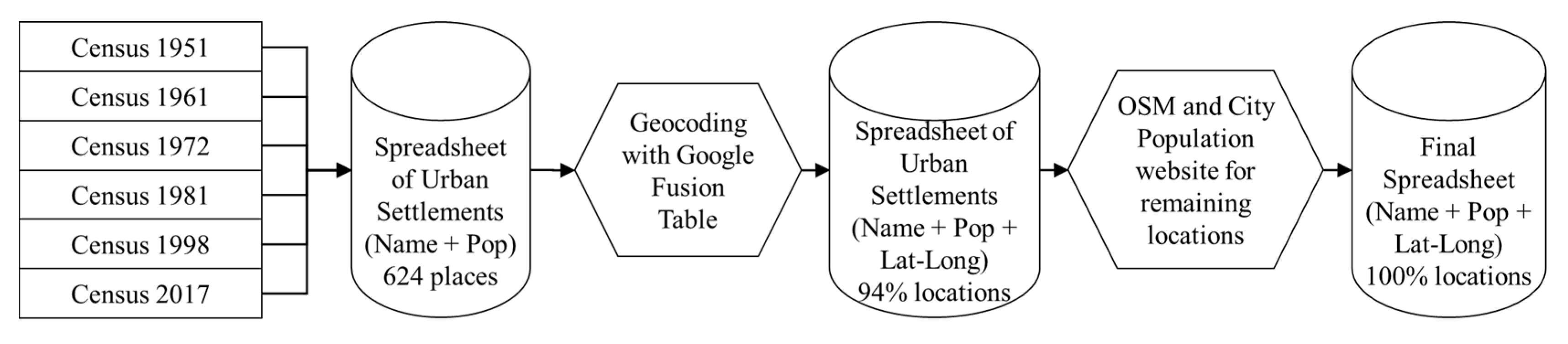
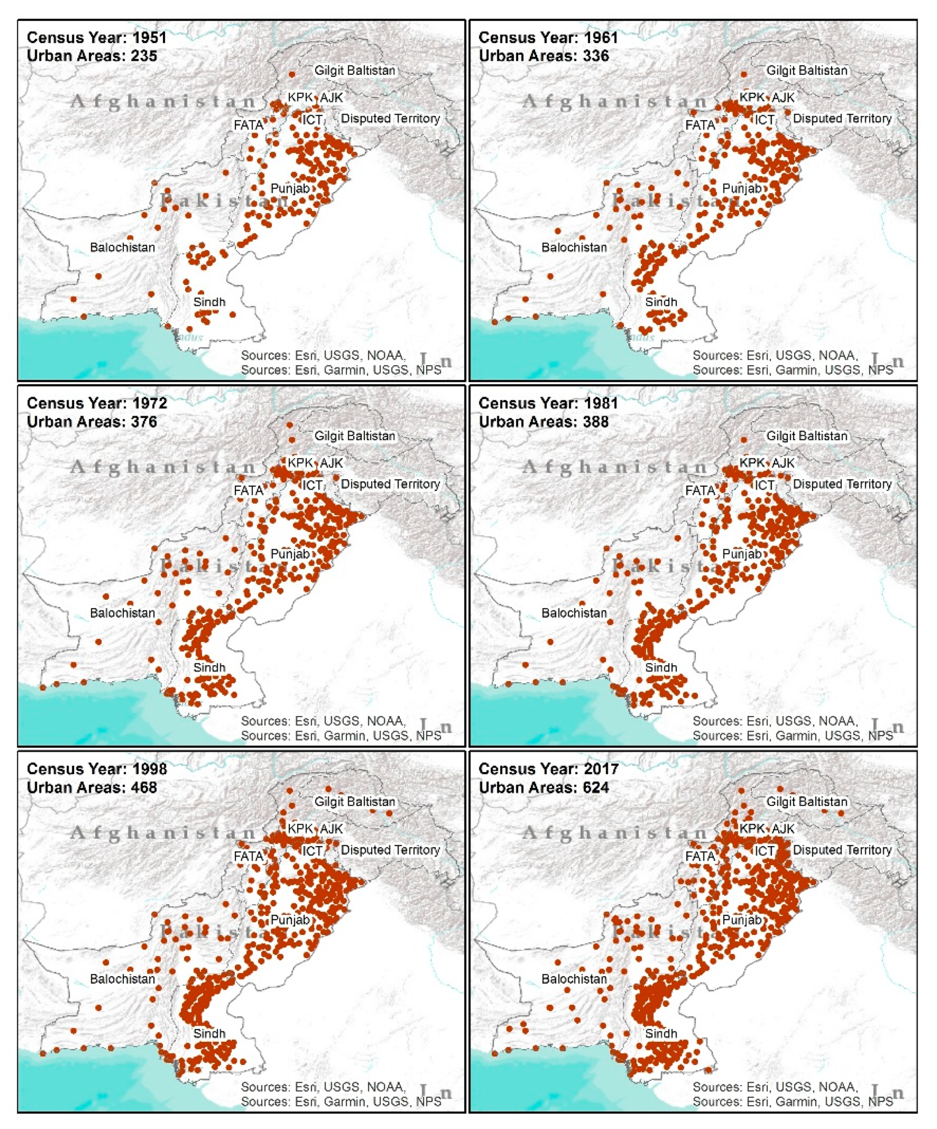
- Extraction of declared urban areas from the census dataEvery national census (1951, 1961, 1972, 1981, 1998 and 2017) has declared a set of settlements as ‘urban’, based on varied definitions. The census data has been published by Pakistan Bureau of Statistics in the form of PDF documents without digitally sortable tables. PDF to MS Excel conversion with optical character recognition (OCR) techniques, along with a Python based rows sorting mechanism, have been applied to extract data, which was then manually sorted to pick urban settlements. Finally, a matrix has been generated to document the increase in the number of declared urban settlements over the census periods among various provinces. The urban settlements have been mapped using the geocoding process to visualize the temporal increase in urban areas. To geocode the place names, a combination of Google Fusion Tables and place names from Open Street Maps (www.openstreetmap.org) and City Population (http://citypopulation.de/) have been used (See Figure 1).
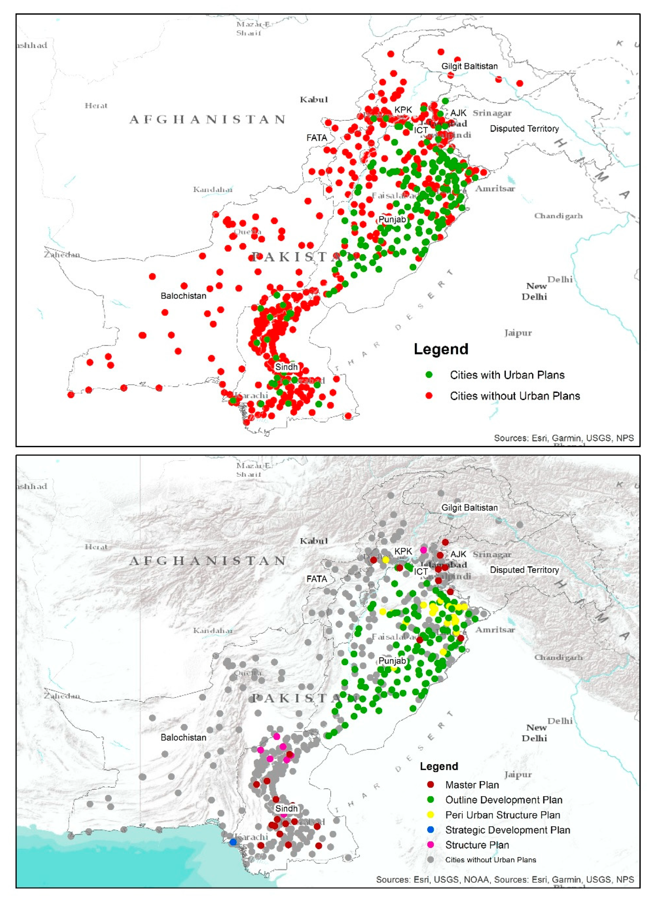
- Prepare an inventory of all spatial plans in PakistanFrom the review of online resources and departmental libraries, a list of spatial plans has been developed, along with key meta data attributes, including spatial plan type, preparing agency, year of preparation, plan duration, approval status and status of plan validity. It is important to highlight that most of the previous plans have been collected in a printed or scanned format, which are not computer text readable. Hence, we have done a manual meta data listing for the preparation of an inventory, instead of a content based lexical analysis. Entries for the inventory have been searched and populated from multiple sources, listed in Table 2. An effort has been made to collect the means of verifications for each entry in terms of the plan document and/or plan map.
- Literature Review: The literature review has been conducted for two key purposes. First, to understand what has been documented about the causes behind the failure of various urban spatial plans. This review is geographically focused on Pakistan. Second, a semi-systematic review of the published literature has been conducted on a global scale, using EBSCO, Google Scholar, Web of Science and Scopus, to explore the application of scenarios in urban planning. Key terms used for searching include “scenario planning”, “scenario and urban planning”, “scenario planning applications”, “scenario method in land use planning”, “scenario in urban planning projects”. A lot has been written on the scenario method in general, so attention was paid to exploring the application side in the urban planning domain. Furthermore, an effort was made to enlist urban planning projects where scenario planning has been adopted as a process. Lessons from the projects have been used to improvise the spatial plan-making process for Pakistan.
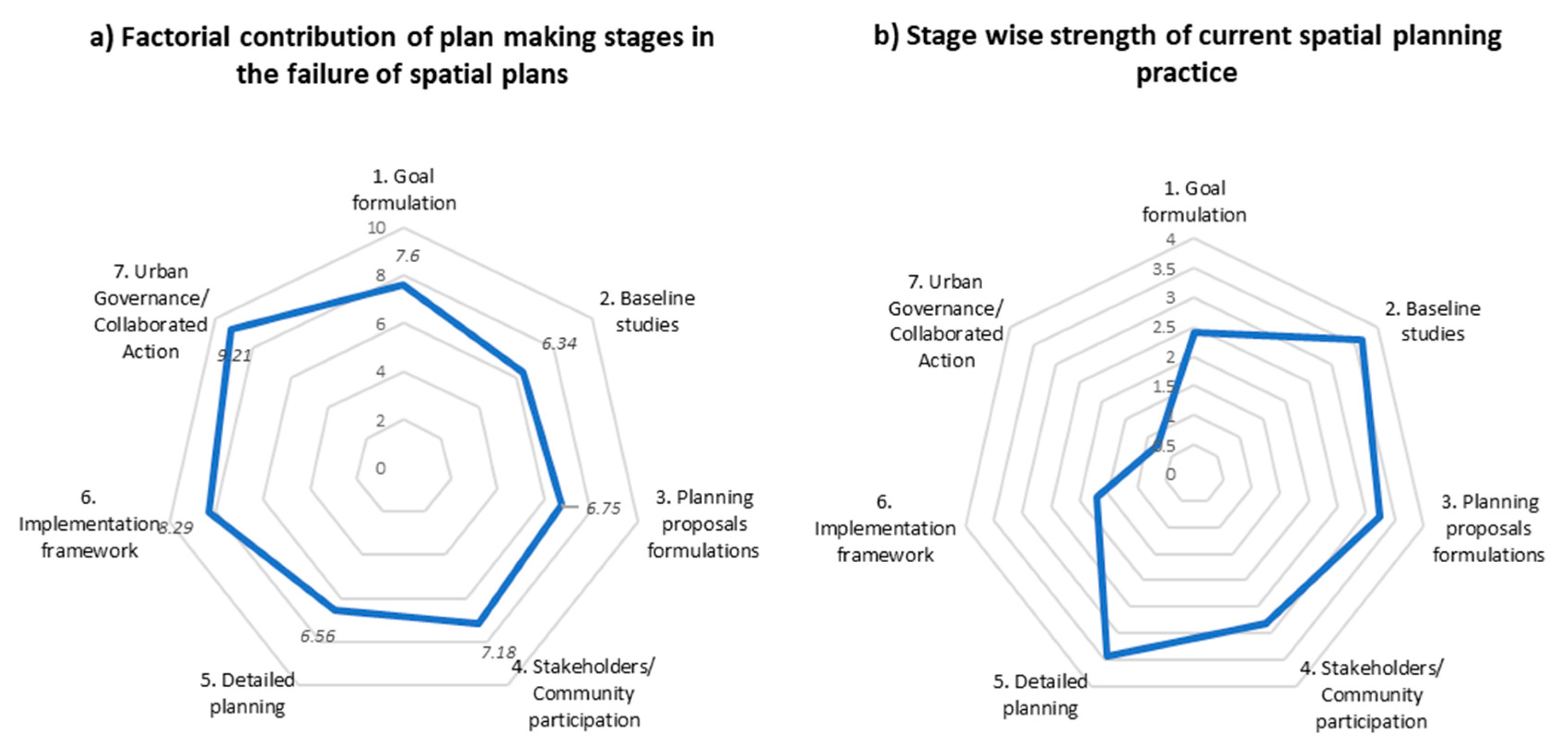
- Experts opinion survey: A two-phased survey of urban planning experts have been conducted in 2019, to record their opinion about the factors behind the failure of urban spatial plans and experts’ aspiration for a futuristic plan-making process. A total of 55 urban and regional planners were contacted, out of which 46 responded. The survey recruitment criteria included “qualified urban and regional planners”, “more than 10 years of experience” and “involvement in a previous urban spatial plan-making process”. An effort was made to get respondents from academia, government, industry and non-government sectors, along with representation from all provinces. In the first phase, experts were asked to share their opinion about “how well the spatial plans were able to achieve their objectives in Pakistan?” on a Likert scale of 1 to 10, where 1 equates not at all, complete failure; 5 = neutral and 10 = to a great extent. They were asked to qualitatively describe the causes behind the failure of spatial plans in narrative form. The qualitative data, so collected, were analyzed using the Selective Lexicon Approach-Level-3 [96]. Resultantly, the key words were generated, and a list of 26 factor statements were developed against seven major stages of traditional plan making process. The seven stages were also derived from the literature review, and the first round of experts’ opinion. In the second phase, the list of twenty-six factor-statements was presented to the experts, to express their opinion about the contribution of each factor towards the failure of urban spatial plans on a 5-point Likert scale. Furthermore, experts were asked to select which type of urban spatial plans (master plan, outline development plan, peri-urban structure plan, regional plans, structure plan) have performed better in the context of Pakistan and why. In addition, experts were asked to respond some open-ended questions, to document their suggestions on potential improvements in the spatial plan-making process, the viability of data-driven planning and readiness for adopting future-oriented planning approaches.
- Finally, the research synthesizes the lessons and findings of all the above-mentioned processes, and concludes by offering a way forward.
4. Discussion and Results
4.1. Documentation of Declared Urban Areas vs. Spatial Plans’ Availability
4.2. Factors Contributing to the Failure of Spatial Plans
4.3. Scenario Planning; a Promising Solution to Uncertainty and Complexity
5. Future Shape of the Spatial Plans
6. Conclusions and Future Work
Author Contributions
Funding
Acknowledgments
Conflicts of Interest
References
- ABS. Australian Statistical Geography Standard (ASGS): Volume 4—Significant Urban Areas, Urban Centres and Localities. 2017. Available online: https://www.abs.gov.au/ausstats/abs@.nsf/Lookup/by Subject/1270.0.55.004~July 2016~Main Features~Different Definitions of Urban~6 (accessed on 10 April 2020).
- Adeel, M. Assessing the Implementation of Rawalpindi’s Guided Development Plan through GIS and Remote Sensing. 2010. Available online: http://geomultimedia.at/archive/CORP2010_201.pdf (accessed on 15 May 2020).
- Afzal, M. Evaluation of Peri-Urban Structure Plan Practices in Punjab. Master’s Thesis, University of Engineering and Technology, Lahore, Pakistan, 2016. [Google Scholar]
- Ahmad, N. Development Plan Practices to Manage Spatial Growth in Major Cities of Pakistan a Case Study of Peshawar City; University of Engineering and Technology: Lahore, Pakistan, 2012. Available online: http://prr.hec.gov.pk/jspui/handle/123456789/2768 (accessed on 15 May 2020).
- Ahmad, N.; Ghulam, A.A. Legal and Institutional Perplexities Hampering the Implementation of Urban Development Plans in Pakistan. Cities 2012, 29, 271–277. [Google Scholar] [CrossRef]
- Ali, R. Underestimating Urbanization. Econ. Political Wkly. 2002, XXXVII, 44–45. Available online: https://mittalsouthasiainstitute.harvard.edu/wp-content/uploads/2013/10/1-Underestimating-urbanisation.pdf (accessed on 15 May 2020).
- Arif, D. Estimating Urbanization. Urban Gazettee. 2013. Available online: https://mittalsouthasiainstitute.harvard.edu/wp-content/uploads/2013/10/Estimating-Urbanization.pdf (accessed on 15 May 2020).
- Angel, S.; Sc, S. The Dynamics of Global Urban Expansion. Transp. Urban 2005. [Google Scholar] [CrossRef]
- Anjum, G.A. Assessment of Urban Land Development and Management Practices in Five Cities of Punjab. Lahore. 2008. Available online: http://www.urbanunit.gov.pk/PublicationDocs/28.pdf (accessed on 19 March 2017).
- APA. Scenario Planning Knowledge Base. 2019. Available online: https://www.planning.org/knowledgebase/scenarioplanning/ (accessed on 15 May 2020).
- Arif, G.M.; Sabiha, I.; Tauseef, A. The Process of Urbanisation in Pakistan, 1951–1998. Pak. Dev. Rev. 1998, 37, 507–522. Available online: http://www.jstor.org/stable/41261068 (accessed on 15 May 2020). [CrossRef]
- Aziz, A.; Shakir, M.M.; Ijaz, A. Master Planning Under Legislative and Organizational Impediments (A Case Study of Lahore). Tech. J. Univ. Eng. Technol. (UET) Taxila Pak. 2014, 19. Available online: http://tj.uettaxila.edu.pk/older-issues/2014/No4/6-Master Planning Under Legislative and Organizational Impediments.pdf (accessed on 15 May 2020).
- Balk, D.; Montgomery, M.R.; Engin, H.; Lin, N.; Major, E.; Jones, B. Urbanization in India: Population and Urban Classification Grids for 2011. Data 2019, 4, 35. [Google Scholar] [CrossRef]
- Bartholomew, K. Integrating Land Use Issues into Transportation Planning: Scenario Planning. Utah. 2005. Available online: https://collections.lib.utah.edu/ark:/87278/s6qv44kf (accessed on 15 May 2020).
- Bartholomew, K. Land Use-Transportation Scenario Planning: Promise and Reality. Transportation 2007, 34, 397–412. [Google Scholar] [CrossRef]
- Bishop, I.; Pettit, C.; Van, B.; Lynch, J. Visualising What If? Generated Land Use Planning Scenarios. In Proceedings of the 11th International Conference on Computers in Urban Planning and Urban Management (CUPUM), Hong Kong, China, 16–18 June 2009; Hong Kong University Press: Hong Kong, China. Available online: http://www.dupad.hku.hk/cupumhk/ (accessed on 15 May 2020).
- Brail, R.K.; Richard, E.K. Planning Support Systems for Cities and Regions; Lincoln Institute of Land Policy: Cambridge, UK, 2008. [Google Scholar]
- Butt, W.A. An Evaluation of Outline Development Plan with Special Reference to Gujranwala Division. Master’s Thesis, University of Engineering and Technology, Lahore, Pakistan, 1991. [Google Scholar]
- Buxton, M.; Alvarez, A.; Butt, A.; Farrell, S.; Densley, L.; Pelikan, M.; O’neill, D. Scenario Planning for Melbourne’s Peri-Urban Region; RMIT University: Melbourne, Australia, 2011. [Google Scholar]
- Chakraborty, A.; McMillan, A. Scenario Planning for Urban Planners: Toward a Practitioner’s Guide. J. Am. Plan. Assoc. 2015, 81, 1–12. [Google Scholar] [CrossRef]
- Chermack, T.J.; Lynham, S.A.; Ruona, W.E. A Review of Scenario Planning Literature. Futures Res. Q. 2001, 17, 7–32. [Google Scholar]
- Ergen, Y. An Overview of Urban and Regional Planning; Ergen, Y.B., Ed.; IntechOpen: London, UK, 2018. [Google Scholar]
- Eurostat. Urban Europe—Statistics on Cities, Towns and Suburbs; Eurostat: Luxembourg, 2016. [Google Scholar] [CrossRef]
- Freitas, H.; Moscarola, J.; Jenkins, M. Content and Lexical Analysis: A Qualitative Practical Application. ISRC 1998, 35, 070498. [Google Scholar]
- Futrell, J. Summer Scenarios: Educational Webinar Series. 2018. Available online: http://www.scenarioplanning.io/summer-scenarios/ (accessed on 15 May 2020).
- Futrell, J. How to Design Your Scenario Planning Process, No. July/August. 2019. Available online: https://planning-org-uploaded-media.s3.amazonaws.com/publication/download_pdf/PASMEMO-2019-07-08.pdf (accessed on 15 May 2020).
- Geertman, S.; Ferreira, J.J.; Goodspeed, R.; Stillwell, J. (Eds.) Planning Support Systems and Smart Cities; Springer International Publishing: Kam, Switzerland, 2015. [Google Scholar]
- Geertman, S.; John, S. (Eds.) Planning Support Systems in Practice; Springer: Heidelberg, Germany, 2003. [Google Scholar]
- Godet, M.; Fabrice, R. Creating the Future: The Use and Misuse of Scenarios. Long Range Plan. 1996, 29, 164–171. [Google Scholar] [CrossRef]
- Goodspeed, R. Scenario Planning Course Development Guide; Lincoln Institute of Land Policy: Cambridge, MA, USA, 2015. [Google Scholar]
- Goodspeed, R. An Evaluation Framework for the Use of Scenarios in Urban Planning; Working paper: WP17RG1; Lincoln Institute of Land Policy: Cambridge, MA, USA, 2017. [Google Scholar]
- Goodspeed, R. Scenario Planning for Cities and Regions Managing and Envisioning Uncertain Futures; Lincoln Institute of Land Policy: Cambridge, MA, USA, 2020; Available online: https://cup.columbia.edu/book/a/9781558444003 (accessed on 15 May 2020).
- GoP. 6th Population and Housing Census 2017 (Provisional Results). 2018a. Islamabad: Pakistan Bureau of Statistics. Available online: http://www.pbs.gov.pk/sites/default/files//Population_Census_2017_Results_0.pdf (accessed on 15 May 2020).
- GoP. Punjab Cities Growth Atlas 1995–2015. Lahore. 2018. Available online: http://uu.urbanunit.gov.pk/enewsletters/urbanatlas/index.html#p=1 (accessed on 15 May 2020).
- GOP, MOCC. National Report of Pakistan for HABITAT III. Islamabad. 2015. Available online: http://habitat3.org/wp-content/uploads/Pakistan-Final-in-English.pdf (accessed on 15 May 2020).
- Hameed, R.; Obaidullah, N. Challenges of Implementing Urban Master Plans: The Lahore Experience. Int. J. Soc. Behav. Educ. Econ. Bus. Ind. Eng. 2008, 2, 1297–1304. Available online: http://citeseerx.ist.psu.edu/viewdoc/download?doi=10.1.1.307.7582&rep=rep1&type=pdf (accessed on 15 May 2020).
- Hameed, R.; Nadeem, O. Punjab Land Use Classification, Reclassification and Redevelopment Rules: A Predicament or New Approach to Urban Management. Ali 2011, 4, 67–76. [Google Scholar]
- Holway, J.; Gabbe, C.J.; Hebbert, F.; Lally, J.; Matthews, R.; Quay, R. Opening Access to Scenario Planning Tools. Policy Focus Report. 2012. Available online: https://www.lincolninst.edu/pubs/2027_Opening-Access-to-Scenario-Planning-Tools (accessed on 15 May 2020).
- Hopkins, L.D.; Marisa, A.Z. (Eds.) Engaging the Future; Forecasts, Scenarios, Plans and Projects; Lincoln Institute of Land Policy: Cambridge, MA, USA, 2007; Available online: https://www.lincolninst.edu/publications/books/engaging-future (accessed on 15 May 2020).
- Hubacek, K.; Laixiang, S. A Scenario Analysis of China’s Land Use and Land Cover Change: Incorporating Biophysical Information into Input-Output Modeling. Struct. Chang. Econ. Dyn. 2001, 12, 367–397. [Google Scholar] [CrossRef]
- Huss, W.R.; Edward, J.H. Scenario Planning-What Style Should You Use? Long Range Plan. 1987, 20, 21–29. [Google Scholar] [CrossRef]
- Hussnain, M.Q. A Study on the Utilization of Information and Communication Technology in Preparation and Implementation of Development Plans: A Case Study of Rawalpindi. Master’s Thesis, University of Engineering and Technology, Lahore, Pakistan, 2013. [Google Scholar]
- Hussnain, M.Q.; Anjum, G.A.; Wakil, K.; Tharanga, P.H.T.D. Improving Efficiency in Data Collection for Urban Development Plans through Information and Communication Technology. In International Conference on Town Planning and Urban Management (ICTPUM); Anjum, G.A., Ed.; University of Engineering and Technology: Lahore, Pakistan, 2014. [Google Scholar]
- Hussnain, M.Q.; Waheed, A.; Anjum, G.A.; Naeem, M.A.; Hussain, E.; Wakil, K.; Pettit, C.J. A Framework to Bridge Digital Planning Tools’ Utilization Gap in Peri-Urban Spatial Planning; Lessons from Pakistan. Comput. Environ. Urban Syst. 2020, 80, 101451. [Google Scholar] [CrossRef]
- Hussnain, M.Q.; Waheed, A.; Wakil, K.; Tahir, A.; Pettit, C.; Pelizaro, C.; Jabbar, J.A. A Planning Support System to Aid Spatial Planning in Pakistan. In Proceedings of the 15th International Conference on Computers in Urban Planning and Urban Management (CUPUM2017), Adelaide, Australia, 11–14 July 2017; University of South Australia: Adelaide, Australia, 2017. [Google Scholar]
- Hussnain, M.Q.; Khydija, W.; Abdul, W.; Ali, T. A Planning Support System to Optimize Approval of Private Housing Development Projects. IOP Conf. Ser. Earth Environ. Sci. 2016, 37, 012050. [Google Scholar] [CrossRef]
- Hussnain, M.Q.; Waheed, A.; Anjum, G.A.; Naeem, M.A.; Tahir, A.; Pettit, C.; Hussain, E. Application of the Online WhatIf? Planning Support System in Peri-Urban Spatial Planning; Case Study of Muzaffargarh, Pakistan. In Proceedings of the 24th International Conference on Urban Planning and Regional Development in the Information Society 2019, Karlsruhe, Germany, 2–4 April 2019; Volume 4, pp. 77–87. [Google Scholar]
- Jan, B.; Mohammad, I.I. Urbanization Trend and Urban Population Projections of Pakistan Using Weighted Approach. Sarhad J. Agric. 2008, 24, 173–180. Available online: http://www.aup.edu.pk/sj_pdf/Urbanization trend and rban population projections of pakis.DOC.pdf (accessed on 15 May 2020).
- Kahila, M.; Marketta, K. SoftGIS as a Bridge-Builder in Collaborative Urban Planning; Springer: Dordrecht, The Netherlands, 2009. [Google Scholar]
- Kahn, H.; Wiener, J.A. The Next Thirty-Three Years: A Framework for Speculation. Daedalus 1967, 96, 705–732. [Google Scholar]
- Khakee, A. Scenario Construction for Urban Planning. Omega 1991, 19, 459–469. [Google Scholar] [CrossRef]
- Kim, Y.M.; Bang, J.; Hyeon, S.K. A Planning Support System as a Tool for Sustainable Urban Planning. In Proceedings REAL CORP 2012; Manfred, S., Vasily, V.P., Peter, Z., Pietro, E., Eds.; Real Corp: Schwechat, Austria, 2012; pp. 1111–1119. [Google Scholar]
- Klosterman, R.E.; Christopher, J.P. An Update on Planning Support Systems. Environ. Plan. B Plan. Des. 2005, 32, 477–484. [Google Scholar] [CrossRef]
- Lazarean, A. OREGON Scenario Planning Guidelines 1 (April). 2013. Available online: https://frego.com/blog/2015/1/6/oregon-scenario-planning-guidelines (accessed on 15 May 2020).
- Van Leeuwen, J.P.; Timmermans, H.J.P. Innovations in Design and Desision Support Systems in Architecture and Urban Planning; Van Leeuwen, J.P., Timmermans, H.J.P., Eds.; Springer: Dordrecht, The Netherlands, 2006. [Google Scholar]
- LILP. Consortium for Scenario Planning. 2018. Available online: http://www.scenarioplanning.io/ (accessed on 12 December 2018).
- Lock, O.; Bednarz, T.; Leao, S.Z.; Pettit, C. A Review and Reframing of Participatory Urban Dashboards. In City, Culture and Society; Elsevier Ltd.: Amsterdam, The Netherlands, 2020. [Google Scholar] [CrossRef]
- Millett, S.M. How Scenarios Trigger Strategic Thinking. Long Range Plan. 1988, 21, 61–68. [Google Scholar] [CrossRef]
- Mirza, M.I. A Review of the Master Plan for Karachi Metropolitan Region. In National Seminar on Planning for Urban Development in the Developing Countries with Special Reference to Pakista; Vanguard Books: Lahore, Pakistan, 1978. [Google Scholar]
- Myers, D.; Alicia, K. Constructing the Future in Planning: A Survey of Theories and Tools. J. Plan. Educ. Res. 2000, 19, 221–231. [Google Scholar] [CrossRef]
- Nadin, V. The Emergence of the Spatial Planning Approach in England. Plan. Pract. Res. 2007, 22, 43–62. [Google Scholar] [CrossRef]
- Nasir, J.; Khan, M. Redefining Urban; A Case for Multi-Criteria Definition of Urban Areas in Pakistan. In 2 Urban; The Urban Unit: Lahore, Pakistan, 2018. [Google Scholar] [CrossRef]
- Nazri, A.; Muhamad, L.; Ahris, Y. Scenario-Based Spatial Modeling for Land Use Planning and Evaluation. Conf. Map Malays. 2006, 3, 4–5. [Google Scholar]
- Okeke, D. Spatial Planning as Basis for Guiding Sustainable Land Use Management. WIT Trans. State Art Sci. Eng. 2015, 86, 153–183. [Google Scholar]
- Owens, S. From ‘predict and Provide’ to ‘Predict and Prevent’? Pricing and Planning in Transport Policy. Transp. Policy 1995, 2, 43–49. [Google Scholar] [CrossRef]
- Paresi, M.; Michelle, M.; Alice, S.; Thomas, K. Atlas of the Human Planet 2016: Mapping Human Presence on Earth with the Global Human Settlement Layer. 2016. Available online: https://ghsl.jrc.ec.europa.eu/atlas2016Overview.php (accessed on 15 May 2020). [CrossRef]
- Patel, M.; Kasper, K.; Dale, S.R. Participatory Scenario Construction in Land Use Analysis: An Insight into the Experiences Created by Stakeholder Involvement in the Northern Mediterranean. Land Use Policy 2007, 24, 546–561. [Google Scholar] [CrossRef]
- Payne, G. Best Practices for Spatial Planning and Development Control in Developing Countries. In International Conference on Land Policy; Arcadis Euroconsult: Jakarta, Indonesia, 2000; Volume 26, Available online: https://www.ucl.ac.uk/dpu-projects/drivers_urb_change/urb_infrastructure/pdf_city_planning/Payne2000_BestPractices_Spatial_Planning.pdf (accessed on 15 May 2020).
- Pettit, C.J.; Hawken, S.; Ticzon, C. Sydney Geodesign Workshop 2016: Developing a Framework for Collaborative Multi-Agency Scenario Planning; City Futures Research Centre, Faculty of Built Environment, UNSW: Sydney, Australia, 2017. [Google Scholar] [CrossRef]
- Pettit, C.; Pullar, D.; Stimson, R. An Integrated Multi-Scaled Decision Support Framework Used in the Formulation and Evaluation of Land-Use Planning Scenarios for the Growth of Hervey Bay. 2002. Available online: http://www.iemss.org/iemss2002/proceedings/pdf/volume uno/216_pettit.pdf (accessed on 15 May 2020).
- Pettit, C.; Pullar, D.V. Towards Incorporating Dynamic Consequences into Regional Planning Scenarios. In AURISA 2000 Conference Proceedings; Roach, C., Ed.; AURISA: Hyatt Regency Coolum, Queensland, Australia, 2000. [Google Scholar]
- Pettit, C.; Bakelmun, A.; Lieske, S.N.; Glackin, S.; Thomson, G.; Shearer, H.; Dia, H.; Newman, P. Planning Support Systems for Smart Cities. City Cult. Soc. 2018, 12, 13–24. [Google Scholar] [CrossRef]
- Pettit, C.J.; Klosterman, R.E.; Nino-Ruiz, M.; Widjaja, I.; Russo, P.; Tomko, M.; Robert, S. The Online What If? Planning Support System. In Planning Support Systems for Sustainable Urban Development; Springer: Berlin, Germang, 2013; Volume 195, pp. 107–125. [Google Scholar] [CrossRef]
- Pettit, C.J. Formulating a Sustainable Development Land Use Scenario Using GIS. ArcNews 2002, 24, 16. Available online: https://www.esri.com/news/arcnews/fall02articles/formulating-sustainable.html (accessed on 15 May 2020).
- Pettit, C.; Keysers, J.; Bishop, I.; Klosterman, R. Applying the What If? Planning Support System for Better Understanding Urban Fringe Growth. In Landscape Analysis and Visualisation: Spatial Models for Natural Resource Management and Planning; Pettit, C., Cartwright, W., Bishop, I., Lowell, K., Pullar, D., Duncan, D., Eds.; Springer: Berlin/Heidelberg, Germany, 2008; pp. 435–454. [Google Scholar]
- Pettit, C.J.; Klosterman, R.E.; Delaney, P.; Whitehead, A.L.; Kujala, H.; Bromage, A.; Nino-Ruiz, M. The Online What If? Planning Support System: A Land Suitability Application in Western Australia. Appl. Spat. Anal. Policy 2015, 8, 93–112. [Google Scholar] [CrossRef]
- Pettit, C.; Biermann, S.; Pelizaro, C.; Bakelmun, A. A Data-Driven Approach to Exploring Future Land Use and Transport Scenarios: The Online What If? Tool. J. Urban Technol. 2020, 0732, 20–44. [Google Scholar] [CrossRef]
- Pettit, C.J.; Ray, W. A Planning Support System Toolkit Approach for Formulating and Evaluating Land-Use Change Scenarios. In Planning Support Systems Best Practice and New Methods; Geertman, S., Stillwell, J., Eds.; Springer: Dordrecht, The Netherlands, 2009; pp. 137–157. [Google Scholar] [CrossRef]
- Pettit, C.; David, P. Planning Scenarios for the Growth of Hervey Bay. 2001. Available online: http://www.geocomputation.org/2001/papers/pettit.pdf (accessed on 15 May 2020).
- Pettit, C.; Pullar, D. A Way Forward for Land-Use Planning to Achieve Policy Goals by Using Spatial Modelling Scenarios. Environ. Plan. B Plan. Des. 2004, 31, 213–233. [Google Scholar] [CrossRef]
- Pettit, C.; Tung-Kai, S.; Robert, S. An On-Line Planning Support System to Evaluate Urban and Regional Planning Scenarios. In Planning Support Systems in Practice. Advances in Spatial Science; Stan, G., John, S., Eds.; Springer: Berlin/Heidelberg, Germany, 2003. [Google Scholar]
- Prieler, S.; Andrés, P.L.; Stefan, A. Three Scenarios for Land-Use Change: A Case Study in Central Europe. Central Europe. 1998. Available online: http://pure.iiasa.ac.at/id/eprint/5449/ (accessed on 15 May 2020).
- Qadeer, M.A. Lahore: Urban Development in the Third World; Vanguard Books: Lahore, Pakistan, 1983. [Google Scholar]
- Roberts, E.J. Exploratory Scenario Planning: Lessons Learned in the Field; Working paper: WP14ER1; Lincoln Institute of Land Policy: Cambridge, MA, USA, 2014. [Google Scholar]
- Russo, P.; Rosa, L.; Maria, F.C.; Christopher, J.P. Adoption and Use of Software in Land Use Planning Practice: A Multiple-Country Study. Int. J. Hum. Comput. Interact. 2018, 34, 57–72. [Google Scholar] [CrossRef]
- Schoemaker, P.J.H. Scenario Planning: A Tool for Strategic Thinking. Long Range Plan. 1995, 28, 117. [Google Scholar] [CrossRef]
- Stojanovic, M.; Petar, M.; Mihailo, M. The Scenario Method in Urban Planning. Facta Univ. Ser. Archit. Civ. Eng. 2014, 12, 81–95. [Google Scholar] [CrossRef]
- Taylor, N. Commentary: What Is This Thing Called Spatial Planning? An Analysis of the British Government’s View. Town Plan. Rev. 2010, 81, 193–208. [Google Scholar] [CrossRef]
- Timmermans, H. Decision Support Systems in Urban Planning and Urban Design. Environ. Plan. B Plan. Des. 1994, 21. [Google Scholar] [CrossRef]
- United Nations. World Urbanization Prospects: The 2014 Revision; United Nations: New York, NY, USA, 2014. [Google Scholar] [CrossRef]
- United Nations. The World’s Cities in 2018-Data Booklet. Available online: https://www.un.org/en/development/desa/population/publications/databooklet/index.asp (accessed on 15 May 2020).
- United Nations. World Urbanization Prospects: The 2018 Revision. United Nations Department of Economic and Social Affairs. 2018. Available online: https://population.un.org/wup/Publications/ (accessed on 15 May 2020).
- USCB. 2010 Census Urban and Rural Classification and Urban Area Criteria. 2012. Available online: https://www.census.gov/programs-surveys/geography/guidance/geo-areas/urban-rural/2010-urban-rural.html (accessed on 15 May 2020).
- Vitriani. Developing a Scenario Development Approach and the Alternative Land Use Scenarios: The Case of Pakal, Benowo, and Sambikerep Districts of Surabaya City. Ph.D. Thesis, University of Twente, Enschede, The Netherlands, 2010. [Google Scholar]
- Volkery, A.; Ribeiro, T.; Henrichs, T.; Hoogeveen, Y. Your Vision or My Model? Lessons from Participatory Land Use Scenario Development on a European Scale. Syst. Pract. Action Res. 2008, 21, 459–477. [Google Scholar] [CrossRef]
- Waddell, P. Integrated Land Use and Transportation Planning and Modeling: Addressing Challenges in Research and Practice. Transp. Rev. 2011, 31, 209–229. [Google Scholar] [CrossRef]
- Walz, A.; Lardelli, C.; Behrendt, H.; Grêt-Regamey, A.; Lundström, C.; Kytzia, S.; Bebi, P. Participatory Scenario Analysis for Integrated Regional Modelling. Landsc. Urban Plan. 2007, 81, 114–131. [Google Scholar] [CrossRef]
- Wibbeling, P. The Scenario-Planning-Process with the Peri-Urban Region of Rostock; HafenCity University: Hamburg, Germany, 2012; pp. 1–22. Available online: https://www.ecologic.eu/sites/files/presentation/2013/wibbeling_052012.pdf (accessed on 15 May 2020).
- Xiang, W.N.; Clarke, K.C. The Use of Scenarios in Land-Use Planning. Environ. Plan. B Plan. Des. 2003, 30, 885–909. [Google Scholar] [CrossRef]
- Yeh, A.G.O. Urban Planning and GIS. Geogr. Inf. Syst. 1990, 2, 877–888. [Google Scholar]
- Zegras, C.; Sussman, J.; Conklin, C. Scenario Planning for Strategic Regional Transportation Planning. J. Urban Plan. Dev. 2004, 130, 2–13. [Google Scholar] [CrossRef]


| Sr. | Year | Study/Project | Country | Reference |
|---|---|---|---|---|
| 1 | 1964, 1992 | Regional growth study of the Green Spring and Worthington Valleys of Baltimore County, Maryland | USA | (McHarg, 1992, pages 79–93; Wallace-McHarg Associates, 1964) |
| 2 | 1966 | An urban development study of the Detroit area | USA | (Doxiadis, 1966; 1967; 1970; Schneider, 1972) |
| 3 | 1975 | A study of energy consumption, land-use, and growth policy for metropolitan Washington, DC | USA | (Roberts, 1975) |
| 4 | 1977 | An urban sprawl impact study for the town of Burlington, Massachusetts | USA | (Fabos and Caswell, 1977) |
| 5 | 1978 | The METLAND comprehensive regional land-use planning methods | USA | (Fabos, et al., 1978) |
| 6 | 1984 | A resource accountability assessment for the town of Greenfield, Massachusetts | USA | (Gross and Fabos, 1984) |
| 7 | 1991 | An urban development policy assessment for the City of Vasteras, Sweden | Sweden | (Khakee, 1991) |
| 8 | 1993 | The alternative urban futures study for the greater San Francisco Bay region, California | USA | (Landis et al., 1993) |
| 9 | 1996 | The New York Regional Plan | USA | (Yaro and Hiss, 1996), |
| 10 | 1996 | The American Planning Association’s guidebook for sustainable development | USA | (APA, 1996) |
| 11 | 1998 | The New Jersey long-range statewide transportation plan study | USA | Bonnett and Olson, 1998, pages 313–320) |
| 12 | 1998 | Three Scenarios for Land-Use Change: A Case Study in Central Europe | Austria | (Prieler, Leskó, and Anderberg 1998) [53] |
| 13 | 2000 | Towards Incorporating Dynamic Consequences into Regional Planning Scenarios | Australia | (C Pettit and Pullar 2000) [54] |
| 14 | 2001 | An urban land-development study of the Santa Barbara region, California | USA | (UCIME, 2001), |
| 15 | 2001 | A scenario analysis of China’s landuse and land-cover change | China | (Hubacek and Sun 2001) [55] |
| 16 | 2001 | Planning Scenarios for the Growth of Hervey Bay | Australia | (Christopher Pettit and Pullar 2001) [56] |
| 17 | 2001 | Formulation an On-line Spatial Decision Support System for Evaluating urban and Regional Planning Scenarios | Australia | (Christopher Pettit, Shyy, and Stimson 2003) [57] |
| 18 | 2002 | The Cambridge Futures study for the City of Cambridge, England | USA | Echenique, 1999; Roberts, 2002 |
| 19 | 2002 | Formulating a Sustainable Development Land Use Scenario Using GIS | Australia | (Christopher James Pettit 2002) [58] |
| 20 | 2002 | An Integrated Multi-Scaled Decision Support Framework used in the Formulation and Evaluation of Land-Use Planning Scenarios for the Growth of Hervey Bay | Australia | (Pettit 2002) [59] |
| 21 | 2003 | The Use of Scenarios in Land-Use Planning | USA | (Xiang and Clarke 2003) [34] |
| 22 | 2004 | A way forward for land-use planning to achieve policy goals by using spatial modelling scenarios | Australia | (Christopher Pettit and Pullar 2004) [60] |
| 23 | 2006 | Scenario based spatial modelling for landuse planning and evaluation | Malaysia | (Nazri, Ludin, and Yaakup 2006) [61] |
| 24 | 2007 | Participatory scenario analysis for integrated regional modelling | Switzerland | (Walz et al. 2007) [62] |
| 25 | 2007 | Participatory scenario construction in land use analysis: An insight into the experiences created by stakeholder involvement in the Northern Mediterranean | EU | (Patel, Kok, and Rothman 2007) [63] |
| 26 | 2008 | Your Vision or My Model? Lessons from Participatory Land Use Scenario Development on a European Scale | EU | (Volkery et al. 2008) [64] |
| 27 | 2009 | A Planning Support System Toolkit Approach for Formulating and Evaluating Land-use Change Scenarios | Australia | (Christopher James Pettit and Wyatt 2009) [65] |
| 28 | 2009 | Visualising What If? generated land use planning scenarios | Australia | (Bishop et al. 2009) [66] |
| 29 | 2010 | Developing a scenario development approach and the alternate landuse scenarios | Indonesia | (Vitriani 2010) [67] |
| 30 | 2013 | Scenario Planning Guidelines for developing and evaluating alternative land-use and transportation scenarios, Utha, Missoula, Portland, Albany, Michigan, California | USA | (Lazarean 2013) [68] |
| 31 | 2014 | The scenario method in urban planning | Serbia | (Stojanovic, Mitkovic, and Mitkovic 2014) [43] |
| 32 | 2015 | Scenario Planning Course Development Guide | USA | (Goodspeed 2015) [69] |
| 33 | 2015 | Scenario Planning for Urban Planners: Toward a Practitioner’s Guide | USA | (Chakraborty and McMillan 2015a) [10] |
| 34 | 2017 | Developing a framework for collaborative multi-agency scenario planning | Australia | (C J Pettit, Hawken, and Ticzon 2017) [70] |
| 35 | 2019 | Scenario Planning Knowledge Base | USA | American Planning Association (APA 2019) [71] |
| 36 | 2020 | Scenario Planning for Cities and Regions Managing and Envisioning Uncertain Futures | USA | (Goodspeed 2020) [72] |
| Sr. No | Source | Website | Coverage |
|---|---|---|---|
| 1 | The Urban Unit, Lahore | http://www.urbanunit.gov.pk/ | Punjab Province |
| 2 | Punjab Housing and Town Planning Agency | https://hudphed.punjab.gov.pk/phata1 | Punjab Province |
| 3 | Urban Policy Unit, Peshawar | http://urbanpolicyunit.gkp.pk/ | Khyber Pakhtunkhwa Province |
| 4 | Directorate of Urban Policy and Strategic Planning | http://www.urbandirectorate.gos.pk/ | Sindh Province |
| 5 | Sindh Cities Improvement Program | - | Sindh Province |
| 6 | North Sindh Urban Services Corporation Limited (NSUSC) | http://www.nsusc.org.pk/ | Sindh Province |
| 7 | Published documents | Various sources | Across Pakistan |
| Province | 1951 | 1961 | 1972 | 1981 | 1998 | 2017 |
|---|---|---|---|---|---|---|
| AJK | 1 | 1 | 1 | 7 | 26 | |
| Balochistan | 17 | 30 | 34 | 31 | 46 | 61 |
| FATA | 2 | 2 | 5 | 16 | ||
| GB | 5 | 5 | ||||
| ICT | 1 | 1 | 1 | 1 | ||
| KPK | 28 | 39 | 42 | 42 | 54 | 62 |
| Punjab | 145 | 164 | 193 | 208 | 242 | 257 |
| Sindh | 31 | 66 | 103 | 127 | 159 | 196 |
| Grand Total | 221 | 302 | 376 | 410 | 519 | 624 |
| Provinces | Declared Urban Areas | Cities That Ever Had a Spatial Plan (Unique) | Total Plans Prepared (Including Cities with 2 or More Plans) | Approval Status | Validity Based on Plan Period | ||||
|---|---|---|---|---|---|---|---|---|---|
| Approved | Not Approved | Not known | Valid in 2019 | Expired | Not Known | ||||
| AJK | 26 | 9 | 9 | 9 | 9 | ||||
| Balochistan | 61 | 2 | 2 | 2 | 2 | ||||
| FATA | 16 | 0 | 0 | ||||||
| GB | 5 | 2 | 2 | 1 | 1 | 1 | 1 | ||
| ICT | 1 | 1 | 4 | 1 | 3 | 1 | 3 | ||
| KPK | 62 | 2 | 5 | 3 | 2 | 2 | 3 | ||
| Punjab | 257 | 140 | 171 | 145 | 25 | 1 | 70 | 101 | |
| Sindh | 196 | 23 | 36 | 1 | 35 | 17 | 3 | 16 | |
| Total | 624 | 179 | 229 | 162 | 31 | 36 | 102 | 111 | 16 |
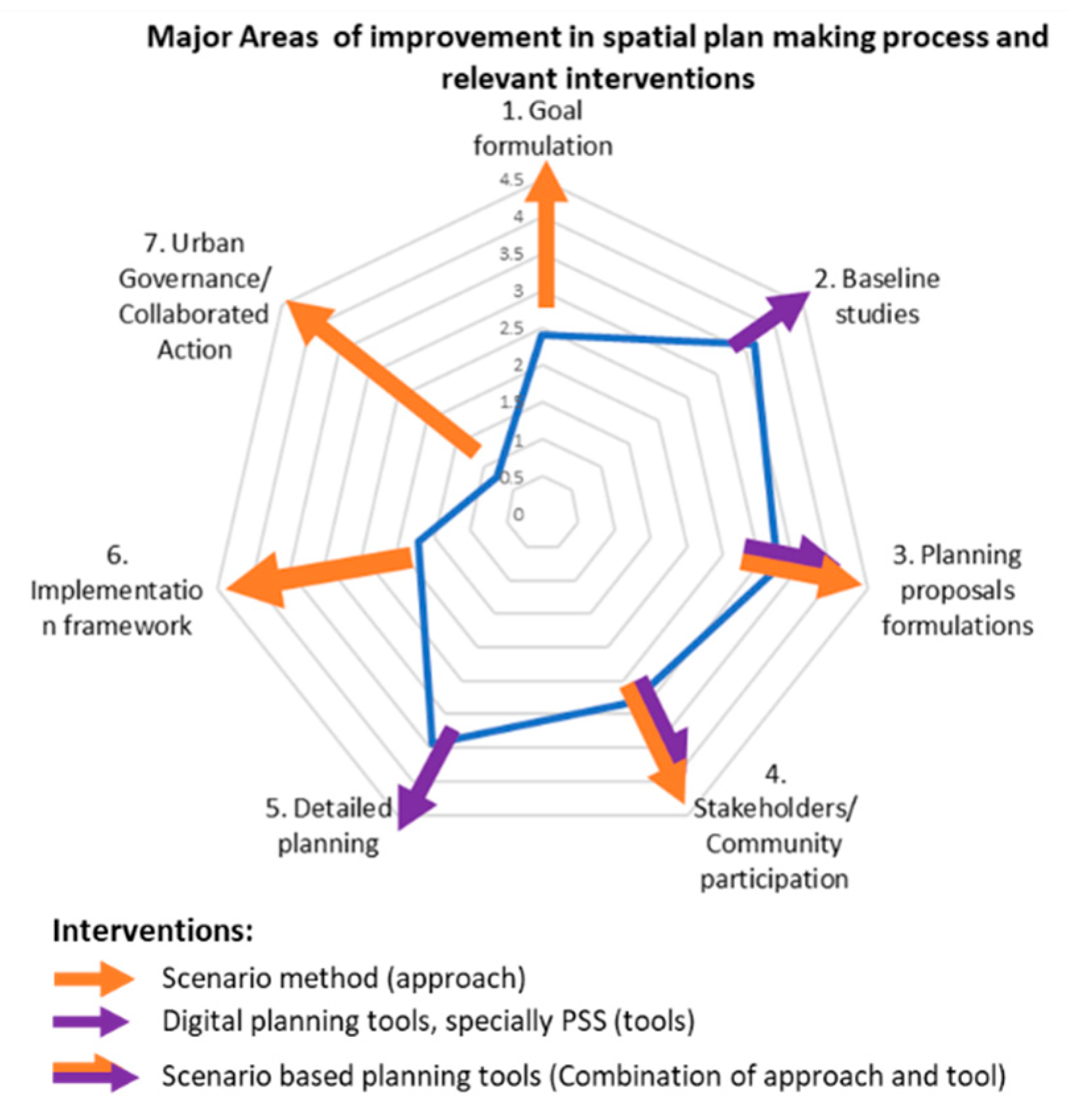
| Urban Plan Making Stage | No. of Factors | Score Representing Stage’s Role as ‘Contributor to Failure’ | Strength of Traditional Plan Making Process |
|---|---|---|---|
| 1. Goal formulation | 2 | 7.6 | 2.4 |
| 2. Baseline studies | 3 | 6.34 | 3.66 |
| 3. Planning proposals formulations | 9 | 6.75 | 3.25 |
| 4. Stakeholders/Community participation | 4 | 7.18 | 2.82 |
| 5. Detailed planning | 3 | 6.56 | 3.44 |
| 6. Implementation framework | 4 | 8.29 | 1.71 |
| 7. Urban governance | 2 | 9.21 | 0.79 |
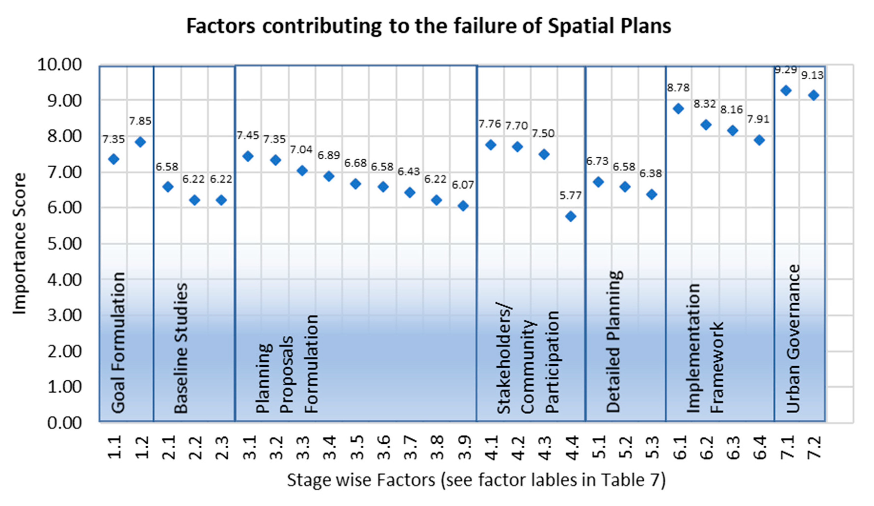
| Urban Plan Making Stages | Factor Label | Factors Contributing to the Failure of Plans | Importance (Scale 1–10) |
|---|---|---|---|
| 1. Goal formulation | 1.1 | Clarity of the implementation agency about the plan type, contents and scale | 7.35 |
| 1.2 | Inability of the agency in prioritizing relevant important themes and ensuring mechanism to assign due priority to the selected themes | 7.85 | |
| 2. Baseline studies | 2.1 | Absence/wrong collection of relevant data | 6.58 |
| 2.2 | Insufficient data collection | 6.22 | |
| 2.3 | Inadequate usage of digital planning tools (IT, GIS, PSS and RS) | 6.22 | |
| 3. Planning proposals formulations | 3.1 | Inability of plan proposals to match with future vision and the absence of mechanism to establish link of proposal with future vision | 7.45 |
| 3.2 | Absence or Inadequacy of alternate proposals | 7.35 | |
| 3.3 | Inability of plan making process to consider all relevant planning variables | 7.04 | |
| 3.4 | Inaccuracy of future estimates and projections | 6.89 | |
| 3.5 | Insufficient data analysis | 6.68 | |
| 3.6 | Insufficient alternate proposals | 6.58 | |
| 3.7 | High time investment on data collection as compared to synthesize in proposal making | 6.43 | |
| 3.8 | Unexpected changes in the real world | 6.22 | |
| 3.9 | Weak contents and lack of comprehensiveness (thematic & geographic coverage) | 6.07 | |
| 4. Stakeholders/Community participation | 4.1 | Lack of community participation | 7.76 |
| 4.2 | Lack of stakeholders’ engagement | 7.70 | |
| 4.3 | Inability to effectively ensure incorporation of stakeholders’ opinions | 7.50 | |
| 4.4 | More focused on donor driven agenda rather than local agency’s needs | 5.77 | |
| 5. Detailed planning | 5.1 | Insufficient skills of the plan making teams | 6.73 |
| 5.2 | Faulty plan making approach | 6.58 | |
| 5.3 | Faulty plan preparation process | 6.38 | |
| 6. Implementation framework | 6.1 | Insufficient capacity of plan implementation agency | 8.78 |
| 6.2 | Absence of legal backing for plan implementation | 8.32 | |
| 6.3 | Delayed plan approval | 8.16 | |
| 6.4 | Absence of financial model to execute planning proposals | 7.91 | |
| 7. Urban Governance | 7.1 | Weak enforcement mechanism | 9.29 |
| 7.2 | Lack of ownership by implementing agency | 9.13 |
© 2020 by the authors. Licensee MDPI, Basel, Switzerland. This article is an open access article distributed under the terms and conditions of the Creative Commons Attribution (CC BY) license (http://creativecommons.org/licenses/by/4.0/).
Share and Cite
Hussnain, M.Q.u.; Waheed, A.; Wakil, K.; Pettit, C.J.; Hussain, E.; Naeem, M.A.; Anjum, G.A. Shaping up the Future Spatial Plans for Urban Areas in Pakistan. Sustainability 2020, 12, 4216. https://doi.org/10.3390/su12104216
Hussnain MQu, Waheed A, Wakil K, Pettit CJ, Hussain E, Naeem MA, Anjum GA. Shaping up the Future Spatial Plans for Urban Areas in Pakistan. Sustainability. 2020; 12(10):4216. https://doi.org/10.3390/su12104216
Chicago/Turabian StyleHussnain, Muhammad Qadeer ul, Abdul Waheed, Khydija Wakil, Christopher James Pettit, Ejaz Hussain, Malik Asghar Naeem, and Ghulam Abbas Anjum. 2020. "Shaping up the Future Spatial Plans for Urban Areas in Pakistan" Sustainability 12, no. 10: 4216. https://doi.org/10.3390/su12104216
APA StyleHussnain, M. Q. u., Waheed, A., Wakil, K., Pettit, C. J., Hussain, E., Naeem, M. A., & Anjum, G. A. (2020). Shaping up the Future Spatial Plans for Urban Areas in Pakistan. Sustainability, 12(10), 4216. https://doi.org/10.3390/su12104216