Concept Paper

Urban Blue Acupuncture: A Protocol for Evaluating a Complex Landscape Design Intervention to Improve Health and Wellbeing in a Coastal Community

1
Chair of Landscape Architecture, Estonian University of life Sciences, Kreutzwaldi 56/3, 51014 Tartu, Estonia
2
Edinburgh School of Architecture and Landscape Architecture, University of Edinburgh, 74 Lauriston Place, Edinburgh EH3 9DF, UK
3
European Centre for Environment and Human Health, University of Exeter Medical School, Knowledge Spa, Royal Cornwall Hospital, Truro, Cornwall TR1 3HD, UK
4
Plymouth Marine Laboratory, Prospect Place, Plymouth PL1 3DH, UK
5
Plymouth City Council, Plymouth, Plymouth PL1 3BJ, UK
*
Author to whom correspondence should be addressed.
Sustainability 2020, 12(10), 4084; https://doi.org/10.3390/su12104084
Submission received: 22 April 2020 / Revised: 11 May 2020 / Accepted: 13 May 2020 / Published: 16 May 2020
(This article belongs to the Section Sustainable Urban and Rural Development)

Abstract

:
Within the BlueHealth project, funded under the Horizon 2020 European Union research framework, a number of targeted experimental design interventions were used to test the effect and impact of planning and design on encouraging people to use various blue spaces. Complex interventions were implemented and evaluations before and after each were made using a set of tools which triangulate with each other—a site assessment tool, a behaviour observation tool, a questionnaire survey (including an economic evaluation) and qualitative interviews. The theoretical basis for the research is that of affordances, and the projects each involved modest changes to the landscape using the approach of “urban acupuncture” where a small intervention can potentially have an effect out of all proportion to the investment. This paper is a protocol paper and describes the research strategy and methodology in detail for one of the intervention sites, located in Plymouth in the UK. The aim is to present the methodology as a whole so as to act as (a) a reference framework for the results of all the projects which will be reported separately in a series of research articles once all the results are in and analysed and (b) a useful reference for other researchers wishing to carry out such complex projects and where a comprehensive presentation of the strategy and methodology is unavailable. We offer this protocol for reference, for critique and for inspiration to those following us.

1. Introduction

1.1. Background

It is well documented that nature and green spaces have the potential to improve people’s health and well-being [1,2,3,4,5,6,7,8]). Given growing urbanisation, a large proportion of the research has focused on urban parks and woodlands [9], and explored the relationships between ‘neighbourhood exposure’ and health outcomes ranging from mortality to momentary well-being [10,11,12,13,14,15,16,17,18]. Neighbourhood exposure has been operationalised variously as the quantity of green space in an individual’s neighbourhood, distances from home to key sites, and general accessibility. Blue spaces have been found to be highly preferred natural settings compared to other urban nature types [19] and there is growing awareness that aquatic or ‘blue spaces’ such as rivers, lakes or the seaside may offer alternative, complementary locations for these relationships [15,17,20,21,22], and this is the focus for the research approach described in this paper.
The quality, as well as quantity and proximity, of green and blue spaces is also important for health and wellbeing [23], as well as being a key predictor of their use and enjoyment [24,25]. Research investigating outdoor environments for activities and place assessment for public space improvements for community benefits has focused on aspects such as the presence of facilities (e.g., paths, benches, attractive vegetation) [23,26,27,28,29,30,31,32,33,34,35,36], and the absence of signs of negative behaviour (e.g., litter, vandalism, dog fouling or broken bottles) [8,37]. These studies showed that there are some basic factors affecting how much people use spaces and the kind of activities they do in them which help to improve physical activity levels (such as by walking, dog walking, jogging or cycling) or for mental health (de-stressing, reducing depression). However, despite this progress, there has been limited research into how specific design interventions to promote greater access to natural environment and place usage may contribute to making a difference in levels of physical activity [38,39,40,41,42], positive effects on health, social and environmental outcomes [43] and may prove beneficial for areas of relative deprivation [21,44]. There is limited research to draw upon and very few studies have assessed the well-being benefits of blue or green space interventions.
In one such study, the concept of “urban acupuncture” [45,46,47,48] was used to test before-and-after effects in Tallinn, Estonia [49]. The research suggested that a simple, small-scale design intervention had a significant positive impact on levels of use of an informal abandoned fishing harbour through behaviour observation techniques, although limited links between the activity and health and well-being could be made. With increasing interest in evidence-based design among practicing landscape architects [50], the lack of research on the impact of specific design solutions may lead to sub-optimal results and a failure to maximise the social return on investment.
The current paper presents a small part of the BlueHealth project, funded through the European Commission Horizon2020 research framework, which focuses on strengthening the evidence base surrounding the potential health and well-being benefits of urban blue spaces (such as docks, rivers, harbours, coastal areas, lakes, canals and water features). The research project as a whole includes a major element of experimental testing of “urban acupuncture” [49] interventions added to a variety of blue spaces located in several cities in Europe, with the objective of identifying the extent to which they attract more people to the space and their degree of impact on the health and well-being of local users. The urban acupuncture theory proposes that a small intervention can potentially have an effect out of all proportion to the investment. Essentially, it is a concept based on both the size/scale of the intervention, and also its cost, as the two frequently go hand-in-hand. Thus, these are small and inexpensive interventions which solve a specific, possibly locally acute, spatial/functional problem (such as a pressure point—hence the metaphor of acupuncture) cost-effectively, rather than a large and complete redevelopment which also costs a lot. What exactly the type of intervention could be is very context dependent and needs clear analysis before carrying out the intervention (such as applying detailed site analysis and public participation). While the problem may be local, the solution may have wider impact.
The current paper focuses on just one of these interventions, as an exemplar of the work carried out across the whole project. The case study is a landscape design intervention in a small run-down urban beach park in a relatively deprived part of the port city of Plymouth, Devon in the UK. The paper describes a brief ‘protocol’ of this particular intervention, the methods used to evaluate the intervention, and illustrates potential outputs from these methods. In so doing, it presents a case for triangulating methods when designing evaluations of comparable interventions, and provides guidance for researchers wishing to conduct similar evaluations. The results of the intervention itself will be presented in future research articles (so we cannot present sample results here, due to the academic constraints of not publishing data more than once) and because of this publication strategy it would not be easy to understand how each set of results fits into the whole. Therefore, the aim is to present the methodology as a whole so as to act as a) a reference framework for the results of all the projects which will be reported separately and b) a useful reference for other researchers wishing to carry out such complex projects and where a comprehensive presentation of the strategy and methodology is unavailable. We offer this protocol for reference, for critique and for inspiration to those following us.

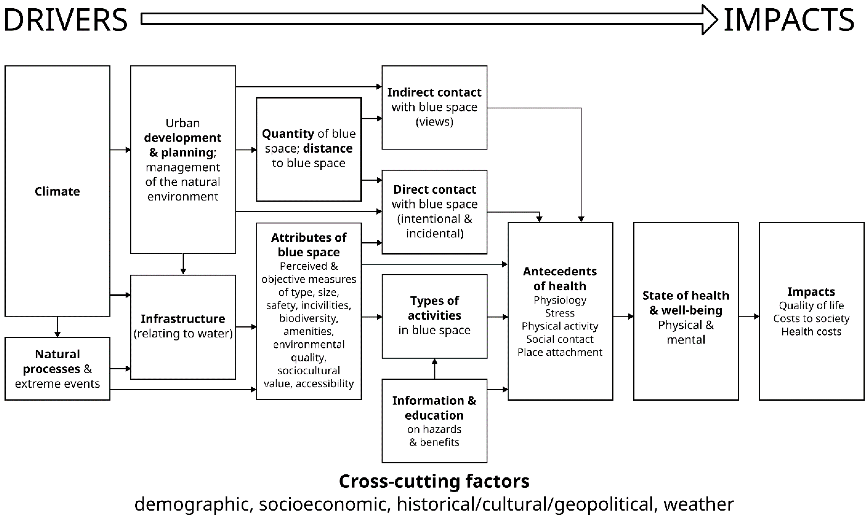
1.2. Conceptual Framework

The research strategy presented here forms a comprehensive, interdisciplinary and multi-method approach which has been applied in various equivalent versions in several other locations across Europe as part of the BlueHealth project. It addresses that part of the project which is concerned with planning and design for blue space (Figure 1). Note the central importance given to planning, infrastructure, quantity of, and distance to, blue space, the attributes of blue space and the means of contact and activities which potentially affect the impacts on health.
The research questions applied to each project are:
1.
To what extent does the renovation of a blue space, by adding a small-scale physical intervention and associated public engagement, attract more people: a) to the site; b) to the water?
2.
How might changes to the blue space (or changes in visit characteristics) have a positive impact on community-level health and well-being?
3.
What are the social and economic values of the intervention?
The main theoretical framework adopted for the research approach is built on affordance theory. Environmental affordances are perceived properties of a place which might influence behaviour [51,52,53]. For example, a physical element such as a ledge may be a functional signifier for designed or spontaneous activities (sitting, skateboarding), highlighting the importance of understanding the physical environment [52]. Affordance as a concept and affordance’s role in designing different physical environments has been amply demonstrated, for example in studies of children’s activity in different play settings [50,51]. Understanding people’s behaviour in outdoor public spaces can provide convincing evidence for urban planning and design, aiming to promote more activity. In the case of blue space, for example, wider views of waterbodies with spacious and natural characteristics, the presence of bank vegetation, a moist atmosphere, rich and diverse wildlife, and non-visual sensory stimulation (e.g., gently lapping waves) may all afford positive perceptions and create fascination, which in turn encourages people to visit the site [9,10].

2. The Study Site

2.1. Plymouth

Plymouth is a coastal city in South West England, famous for its associations with Sir Francis Drake and the defeat of the Spanish Armada in 1588, the departure point for the Pilgrim Fathers on board the Mayflower to North America in 1620 and a major base for the Royal Navy. However, it was also heavily bombed in the Second World War and has a number of areas categorised as highly deprived [54].

2.2. The Active Neighbourhoods Programme
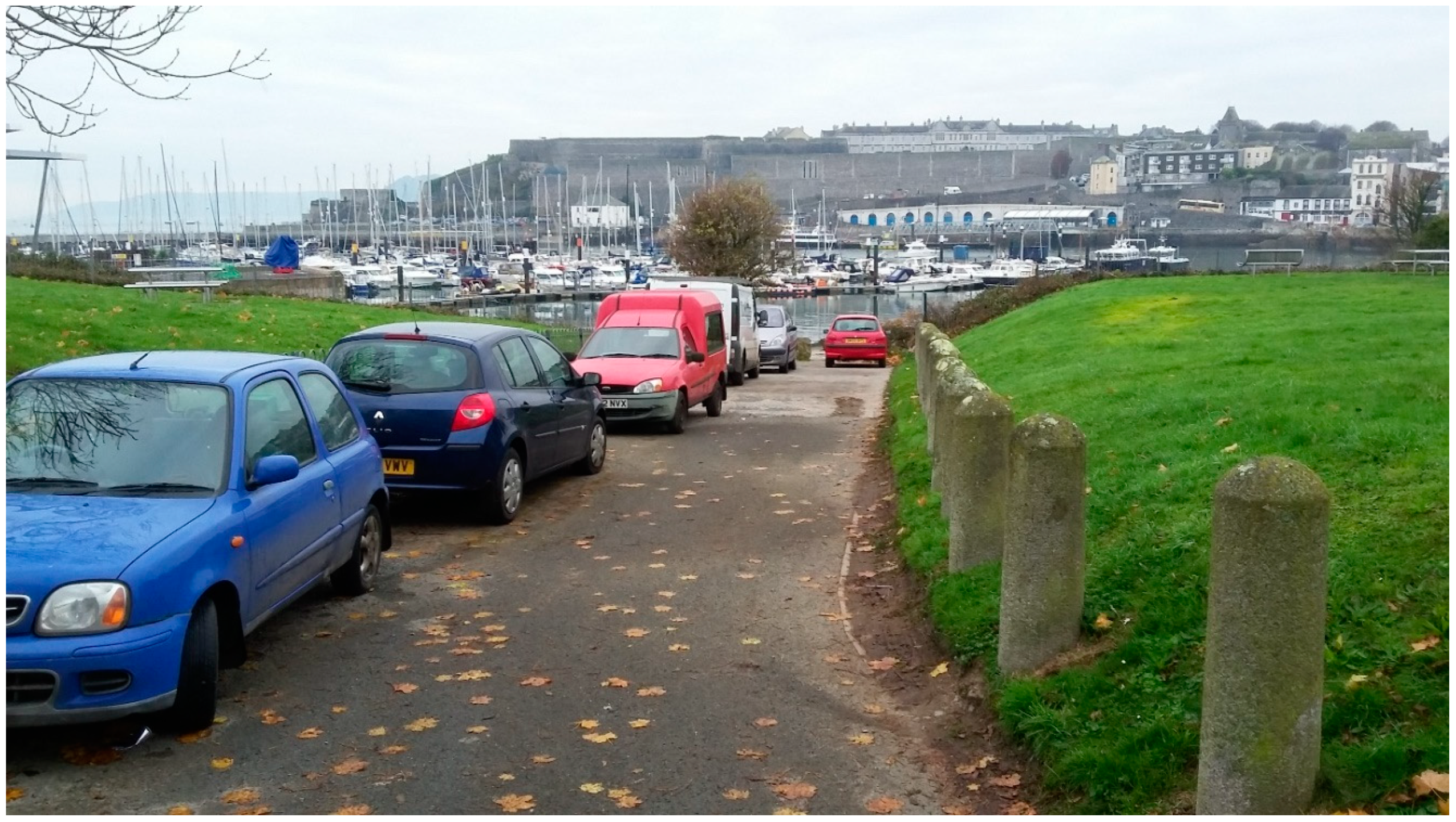
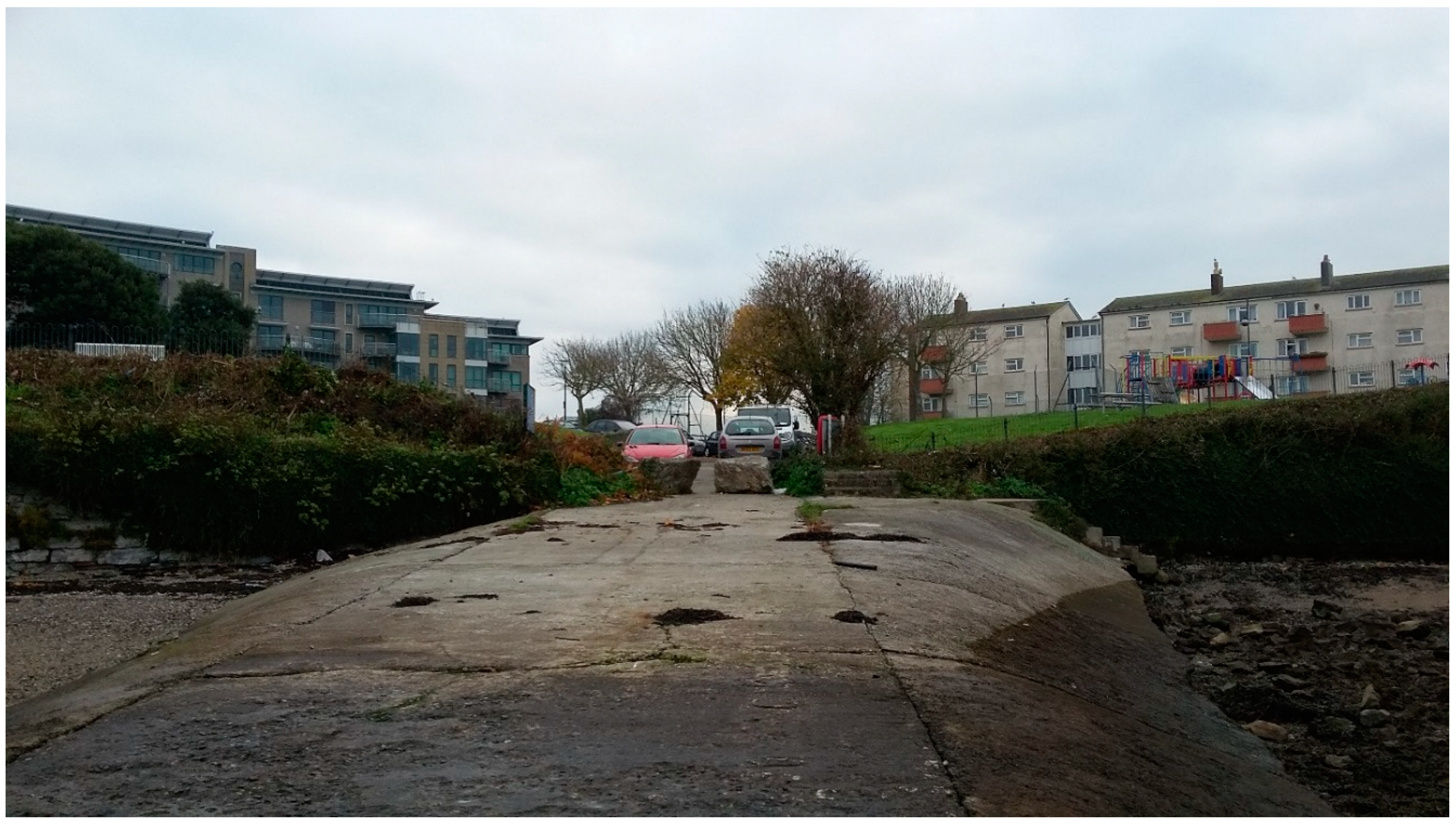
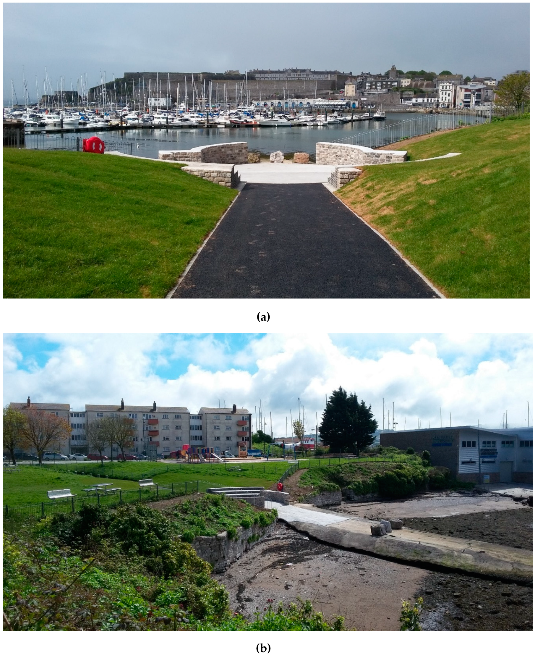
In 2016, Plymouth City Council started the Active Neighbourhoods project. Funded by the Big Lottery Reaching Communities programme, it built on similar greenspace projects previously undertaken in the city [55]. As a partnership between Plymouth City Council (PCC), Devon Wildlife Trust (DWT) and Public Health’s Thrive Plymouth network, over 3 years the project aimed to get more people being more active and feeling better by using and improving their local natural spaces in five more deprived areas of Plymouth. The current case study site, Teats Hill, was identified as an area for improvement within this scheme.
As a public greenspace in an urban area with direct access to the foreshore, BlueHealth researchers identified the Teats Hill area as an ideal site for the intervention research and together formed a project group with staff from the Active Neighbourhoods team and Devon Wildlife Trust to carry out a combined development and research project.

2.3. Teats Hill

Teats Hill is a small park located in the inner harbour of Plymouth. Until the 1980s, it was set within an area of maritime industry and services, after which a period of urban renewal took place, leading to the establishment of the National Marine Aquarium, some residential development and other facilities such as Plymouth University Marine Station. However, since then there was a deterioration in the quality of the infrastructure (facilities and access) at Teats Hill, and access to the urban beach down a slipway was blocked by parked cars and overgrown vegetation which screened views (Figure 2 and Figure 3). One half of the site is overseen by social housing due for renovation (right-side Figure 3), while the other side is overseen by new flats in a gated community (left-side Figure 3).

2.4. A Two Pronged (“Complex”) Intervention: A Community Co-Creation Design Process at Teats Hill

Once Teats Hill had been identified as a site for the intervention, an extensive series of stakeholder meetings and public engagement events were conducted to inform the project. These continued throughout the entire re-development and continue to this day (Supplementary Table S1). Stakeholders were from a variety of backgrounds, including the city council, housing association (who owned the nearby social housing), wildlife trusts, marine biological association, aquarium, local schools and charitable organisations, local universities, conservation groups, and local elected representatives. They were tasked with overseeing the development of the intervention, and raising issues that might be of concern to the environment and its ecology, to the residents living nearby, the parties who owned the land, or the surrounding businesses. They were also responsible for the coordination of public engagement events, assisting with data collection for BlueHealth, and the seeking of further funding for improvements to, and maintenance of, the site.
In a series of such stakeholder meetings in 2016, the parameters for the project, the budget, and a series of initial issues identified by the stakeholders were outlined. This information was used to give a framework for the initial design ideas which were sketched out by one of the landscape architect researchers in May 2017 and presented to the stakeholders. Following an initial positive reaction, the ideas were then developed and presented to the local residents in several participation events which took place as part of an extensive and detailed public engagement plan implemented by Plymouth City Council. The project ideas then evolved to the satisfaction of all stakeholders and were approved by the City Council. Funding for the construction was jointly provided by Plymouth City Council and the BlueHealth Project and constructed over the winter of 2017–2018.
Table 1 presents the site renovation work linked to the anticipated affordances. Figure 4 shows plans for the site before (a) and after (b) the interventions. Figure 5 shows: (a) the completed open-air theatre; and (b) a view of the renovated park with open air theatre, the refurbished play area and the residential neighbourhood in the backdrop.
The intervention was therefore what is known as a “complex intervention” [56] in the sense that multiple components converged to form what could be reasonably conceived as influential on people’s behaviour. For example, the renovation works (theatre, play area, vegetation) took place alongside community engagement events coordinated by Plymouth City Council, the introduction of new signage, and other charitable or outreach activities. To delineate the purpose of each intervention component, and to assist with the need for better description of blue space interventions more generally [57], Table 2 lists behaviour change techniques conceptualised in the development of the intervention, and how they were implemented, based on a widely-used ontology in health behaviour change research [58].

3. Research Strategy and Methodology

3.1. Strategy

The overall evaluation strategy was to explore the effects of the intervention within the case study site (which consisted of both a physical change and extensive public engagement) by comparing the pre-intervention baseline situation with post-intervention outcomes. This did not include a complete site makeover of the park (as funds did not permit it) but instead focused on specific core components jointly designed and implemented by the project group with the participation of local residents.
As this paper focuses on outlining the complex suite of methods used to investigate the effectiveness of the blue acupuncture intervention, no results are presented and, as noted above, it is not permitted to publish the same data twice. However, some illustrative outputs are provided in order to show the kind of results obtained (for some aspects) and full results for each method will be reported elsewhere.

3.2. Research Methodology

In order to assess the effect of the intervention, a number of evaluations were carried out on site before and after construction. These consisted of a mix of quantitative and qualitative surveys of the site, of its users, and the local community. The survey instruments were developed within the BlueHealth project for application across all case studies and in the case of Teats Hill were supplemented by additional research into the economic evaluation of the project and some follow-up qualitative interviewing of stakeholders and local residents. The instruments were as follows:

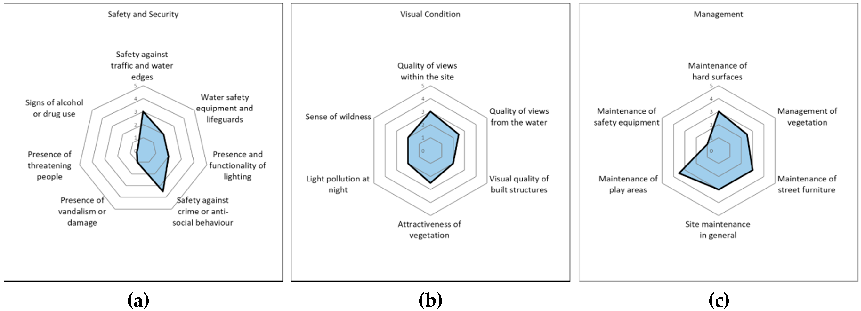
3.2.1. The BlueHealth Environmental Assessment Tool (BEAT)

This tool was developed for the project as a means of assessing a wide range of qualities of a blue space according to a number of domains and aspects. The need for the tool emerged following a search for suitable existing tools that identified a lack of one suited to blue spaces. A tool in two distinct parts was developed, one for the terrestrial part of a blue space and one for the aquatic. This dual approach resulted from different conceptual frameworks found in tools primarily used for land and those for water. The two parts were also developed by experts with different expertise: landscape architecture for the terrestrial assessment and aquatic ecology for the aquatic part.
As part of the development of the terrestrial tool, 28 different existing tools for assessing green and public spaces of various types (such as parks, urban woodlands, streets, beaches etc.) were critically reviewed. The review was used to determine the main elements or factors which such tools use for assessing spaces together with specific aspects for blue spaces which were added following the identification of gaps [59]. The tool is wide-ranging and aimed at assessing the overall quality and functionality of a specific site within the context of its location and local population characteristics. It functions as a way of identifying potential affordances of the space which may be actualised by any interventions which may be made following the analysis. The key indicators which might be expected to change following an intervention in Plymouth mainly concern the land–water interface, although the project was also used as part of the extensive testing and validation across several sites where interventions were more directly targeted manipulations to aquatic features (e.g., the opening up of a derelict spring in Catalonia). The BEAT assessment was used before and after the intervention and systematically documented the extent to which the site had changed/improved in relation to identified weaknesses and actualised affordances. It was administered by several landscape architects (including those from the BlueHealth team) and marine ecologists, and individual scores were cross-checked and any disagreements discussed and resolved among the team. The output of the assessment survey takes the form of “spidergrams” which enable a clear visual comparison of the similarities and differences to be identified (see Figure 6). The tool is freely available and can be accessed online here: https://www.beat.bluehealth.tools/.

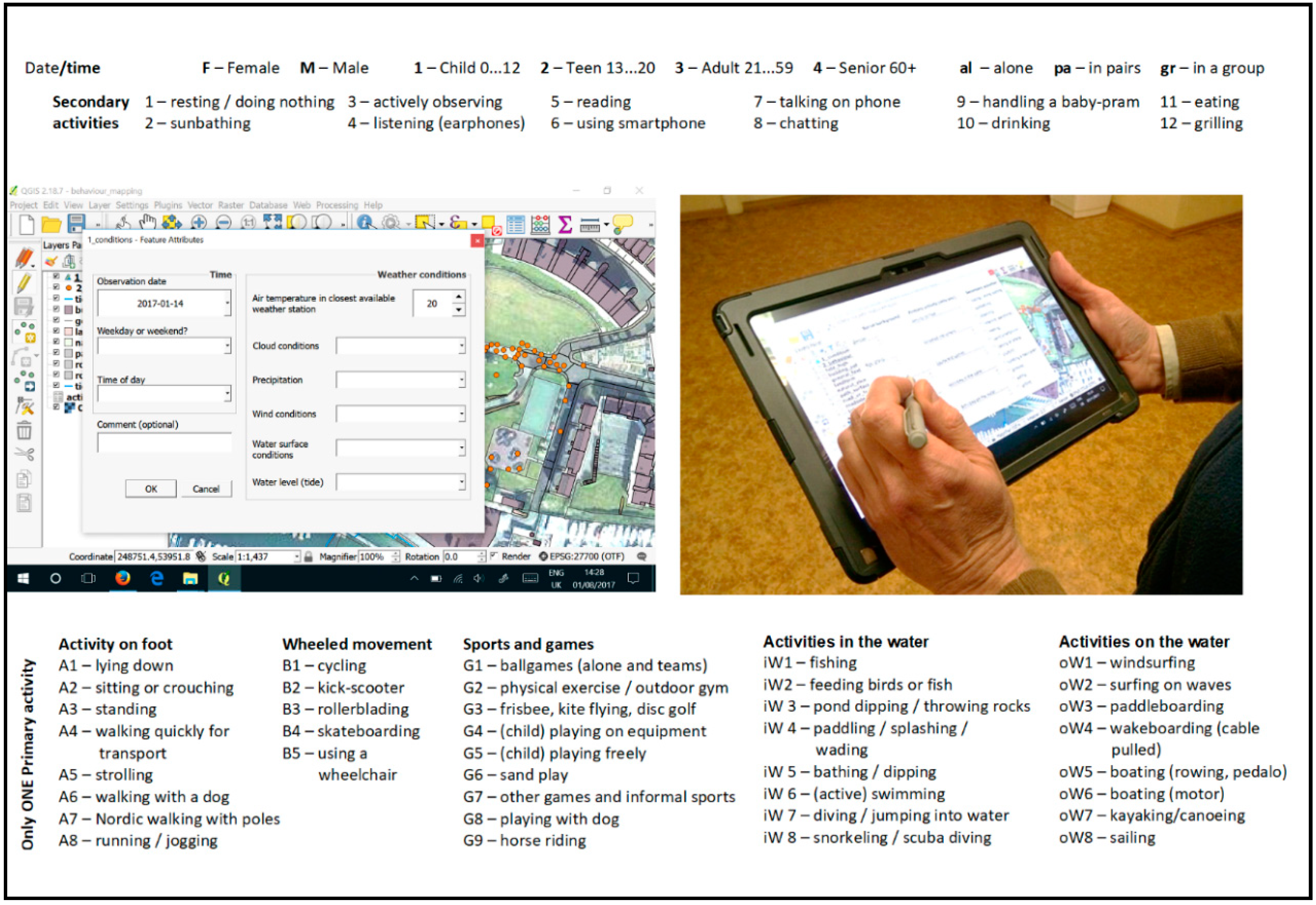
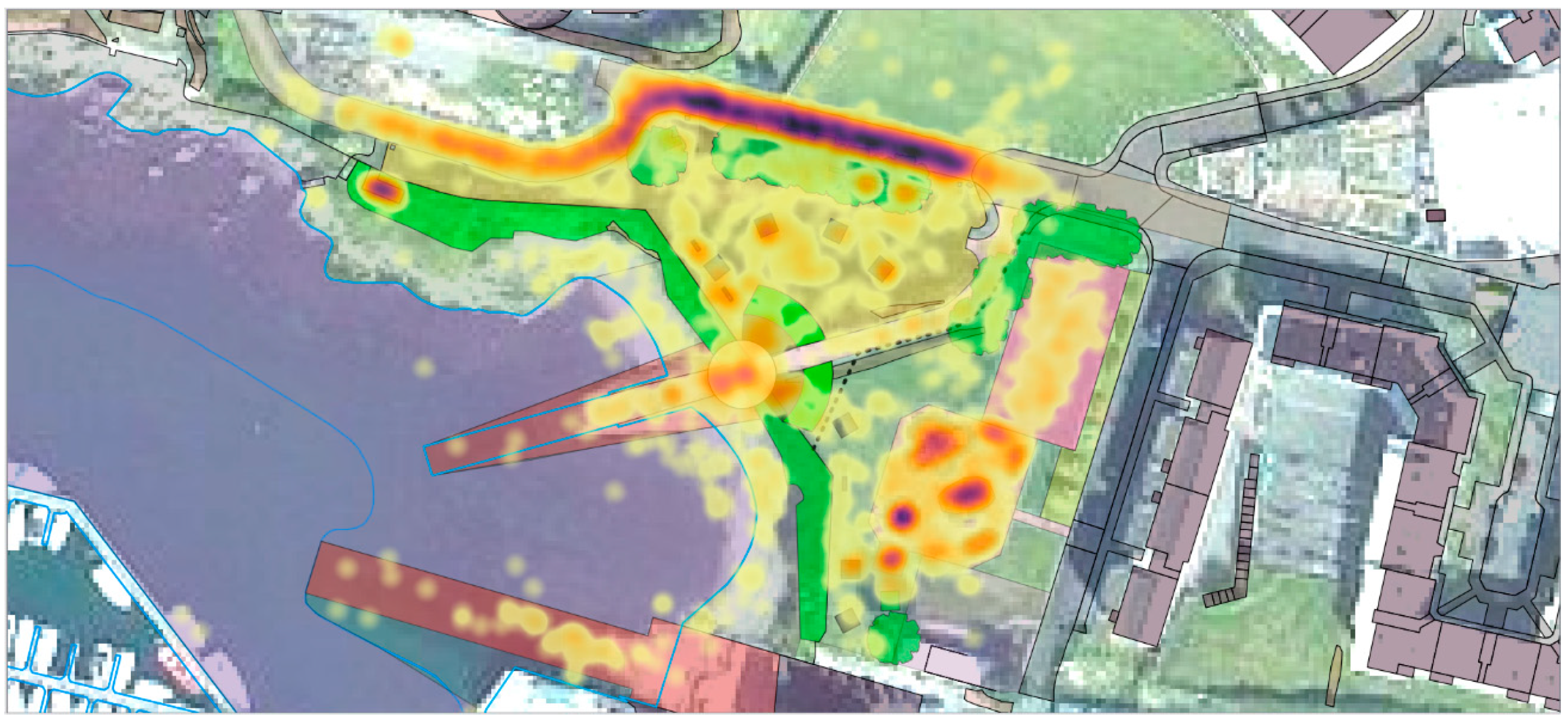
3.2.2. The BlueHealth Behavioural Assessment Tool (BBAT)

The BBAT was designed to capture the profile of activities undertaken by users of a particular site through direct observation rather than self-report (i.e., behavioural mapping). This is a momentary time sampling method which has seen an increase in application in recent years and has moved from being a paper-based mapping approach using a complicated series of symbols [49,60] to a more efficient process using portable devices with a Geographic Information System (GIS), where the potential for analysis is also much greater. The exact location, type of activity and basic demographic characteristics of the users of the area are recorded during systematic on-site observations together with weather and time variables (including day/week/season).
The list of activities was compiled from the Blue Health Community Level Survey (BCLS—see next Section 3.2.3) so as to be able to compare results, followed by on-site validation and adjustments. The BBAT is designed to be compatible with the widely used SOPARC behaviour observation method [61], but captures more granular data on activity types and locations, and contains additional information on blue space interactions and affordances in particular. The collected data can reveal the popular and the less frequented locations within an overall space or among behaviour settings [51], and identify differences in the spatial distribution of activities moderated by social, weather and time variables. Repeated observation campaigns before and after changes to the site, as was the case with the Teats Hill intervention, enable monitoring of changes in usage patterns to inform the degree to which potential affordances were actualised and the extent of the achievement of design goals and, potentially, efficacy of investment.
For larger locations, several monitoring points are used and/or observers walk systematically through the entire area, stopping at predetermined locations to scan the visual field from left to right in full circle. In the case of Teats Hill, the area was small enough that observers could be stationed at a single location with clear visibility of the entire area (Plymouth University’s Marine Building at the south of the site). The site was divided into three segments (the beach; the park, pathway and slipway access road; the children’s play area) and these were observed in a cyclical order for 5 minutes each over a two-hour period.
The location of every user within the scanning area is marked on the map, followed by a series of drop-down menu selections in the GIS interface on a tablet computer (Figure 7). These capture gender, approximate age group, social interaction, primary activities and optional secondary activities. The same techniques as described in SOPARC [61] are used to account for uncertainties (unclear gender, person entering or leaving the scanning area or changing activity) and to overcome overload in crowded situations. Time within the day and week and general weather parameters are recorded at the beginning of the observation session. In order to cover a wider range of weather and temporal conditions, the data are collected once during the observation day, according to a predetermined scheduling scheme of four time periods within a day, alternating between two workdays and one weekend day within a week.
Observations of Teats Hill were carried out over consecutive weeks between June and September 2017 (pre-intervention) and 2018 (post-intervention). Two observers shared the work to reduce fatigue and ensure personal safety while on site. Observations were not carried out during organised events with large crowds.
Planned analyses include descriptive and predictive statistical analysis, e.g., accounting for visitor characteristics, of the observation data obtained from the BBAT. In particular, we are interested in whether different types of users interact with different aspects of the site in different ways following the intervention, with a particular focus on whether the change in environmental affordances is seen to influence the behaviours exhibited in predictable ways. While descriptive analyses may reveal activity and user profiles within the study area, additional visual analysis of the data (e.g., heat maps) reveals activity concentration (Figure 8) related to specific behaviour settings. Regression models with different control variables can be used to reveal predictive and mediating influences of user characteristics, weather, environmental (e.g., behaviour settings, littoral activities etc.) and temporal variables. Statistical hotspot analysis and geographical regression will also be performed to reveal spatial relationships.

3.2.3. BlueHealth Community-Level Survey (BCLS)

Although the BBAT is a highly objective way of monitoring actual behaviour, it is not able to assess: (a) whether visits are made by the same or different people over time; (b) visit duration; (c) motives for visiting the site; (d) visitors’ perceptions of change; or implications for resident/visitor health and well-being. To help fill these gaps, we also developed two further tools: the BlueHealth Community-Level Survey (BCLS) and BlueHealth Site Interview (BSI), Section 3.2.4). The BCLS is a standardised questionnaire delivered face-to-face by a professional market research company and administered to residents in the seven neighbourhoods closest to Teats Hill (which consisted of ≈1000 households). Specifically, a systematic sample of individuals from alternating residences were targeted in the first and second waves of data collection to avoid introducing geographical biases. In order to prepare residents for the coming interviews, postcards giving a very brief overview of the project were delivered to addresses a week before interviewers approached targeted homes, saying that an interviewer may visit their home in the coming week to talk with them about the site. Additional interviews were conducted with individuals at the Teats Hill site itself (so long as the individual lived locally) to potentially compare visitors and non-visitors. A total of 309 and 331 valid responses were collected from June–September 2017 and June–August 2018 (i.e., before and after the construction of the intervention), respectively.
Notably, due to the difficulties and cost of implementing a truly longitudinal survey, with the same participants being surveyed pre and post, the current study used a repeat-cross sectional design, with the aim of sampling matched (but not identical) cohorts. Although longitudinal cohorts are often held up as the ‘gold-standard’, they have issues of their own, including selective participation (including non-random attrition) and greater potential for reactivity (i.e., reporting changes merely by being in a longitudinal study). Table 3 sets out the overall structure of the questionnaire.
The BCLS was designed to assess changes in: (a) self-reported recreational use of the site (see Section 3.2.3 for comparison); (b) perceptions of Teats Hill; and (c) health and wellbeing outcomes, including related metrics such as community cohesion. The majority of items were psychometrically validated and/or internationally established questions with only small adaptations present throughout [62,63]. Questions included: visits to any blue and green spaces in the last 12 months, visits to Teats Hill in the last four weeks, overall perceptions of Teats Hill’s quality, characteristics of their most recent visit (date, duration, motivation, activities undertaken, who accompanied the respondent, satisfaction, connectedness with nature, perceptions of safety and quality), demographic items (sex, age, dog ownership, garden access, household composition, educational attainment, ethnicity, marital status, household income), and health and wellbeing-related items (life satisfaction, satisfaction with other life domains, quality of life, general health, physical activity attainment). These aspects of the survey were deliberately structured to reflect, at a smaller scale, the multi-national BlueHealth International Survey [64] so that we could compare responses at different spatial scales.
Analyses will include comparisons of health and well-being in the community before and after the restoration, with a focus on changes in visit frequency and perceptions of the site in terms of quality, safety etc. Our central hypothesis was that objective improvements in the site (as measured using the BEAT) would lead to increased self-reported use (triangulated with behavioural observations using the BBAT), that in turn would lead to better health and well-being outcomes and greater community cohesion.
Given the increasing importance of justifying value for money/future investment for intervention projects, a unique feature of the Teats Hill survey was the inclusion of items intended to provide data that could inform economic valuation approaches. In the pre-survey, the contingent valuation method (CVM) was used to explore how much participants might be ‘willing to pay’ (WTP) for the renovations. The CVM is a well-established environmental valuation method [65] and is recognised for use in decision-making and cost-benefit analysis [66,67]. The method originated in economics and assesses stated preferences for environmental goods and services to estimate their values [68,69]. The CVM seeks to measure an individual’s value for an environmental good, by directly asking them to state their WTP for a hypothetical change in the quantity or quality of an environmental good [70,71,72] and therefore can be used to estimate value (ex ante), prior to the implementation of an intervention or policy [66]. The method was used here to estimate willingness to pay for: (i) the Teats Hill regeneration (pre-survey) and (ii) the maintenance of the condition of Teats Hill, following the regeneration (post-survey). Respondents were asked to state the maximum amount of money that they would be willing to contribute to a hypothetical fund (the Plymouth Parks Foundation fund) as a one-off payment, for the improvements in question. Best practice guidelines [68,70,73] and quantitative and qualitative pre-testing were used to design a survey instrument, which produced valid and reliable estimates.

3.2.4. BlueHealth Site Interview (BSI)

Finally, using a standard interview protocol (the Blue Health Site Interview, BSI) a number of in-depth qualitative interviews were undertaken post-intervention with members of the stakeholder group (6) and local residents (6 adults and 4 children), in order to add depth to the quantitative results and to obtain some opinions on the process and the results of the intervention project. The interviews were carried out face-to-face on site in July and August 2018. They were recorded, transcribed and analysed for the different themes expressed by the interviewees. Supplementary Table S3 presents the range of questions asked of the stakeholders and adult residents. The interviews with children were carried out as a group discussion together with one of the council youth support workers who supervised the discussion for ethical purposes.

3.2.5. Ethical Approval

Ethical approval was sought and received for the BCLS (University of Exeter) and the interviews (University of Edinburgh). The BBAT was deemed not to need ethical approval as there was no direct interaction with anyone (Estonian University of Life Sciences). The interviews with the children were supervised by a youth worker from Plymouth City Council.

4. Discussion

4.1. Teats Hill in Context

There is growing interest in the possibility that parks and other recreational spaces are public health goods and can significantly contribute to a population’s health and well-being [3,74,75]. Much work around the world is trying to quantify, and even value, these benefits in order to inform planning and spending decisions [76,77]. The BlueHealth project is attempting to contribute to this field in several ways.
First, it focuses on the relatively understudied ‘blue’, or aquatic, spaces. These spaces are among the most popular of all recreational locations [19,78] and have their own unique set of affordances that encourage and support different types of behaviours from merely land-based terrestrial spaces (e.g., swimming, canoeing etc.) [78], and provide different sensual experiences (e.g., light, sounds, smell) [57,79,80,81]. Improving our understanding of how these spaces are used, the impacts interactions with them can have, and testing and informing best-practice design, even at the relatively small (urban acupuncture) level, is needed.
Second, the project uses a highly integrated, multi-disciplinary and multi-measure approach to assess the effect of a landscape intervention—an activity which itself is very rare in research. By developing a blue space-specific evaluation toolbox, including a blue space assessment tool (the BEAT), a blue space-specific behavioural observation tool (BBAT), a resident and visitor survey (BCLS), and a bespoke in-depth interview schedule (BSI), the project makes significant advances on previous, less joined-up, predominantly green space-focused projects [39,75]. By embedding methods of economic evaluation in the BCLS, and by conducting in-depth qualitative interviews with key individuals and residents, the project also responds to the needs of very different stakeholders, from providing the kind of monetary estimates needed by those trying to justify financial investment in a site, to giving an active voice to those most affected by the process [82].
Third, and related to this latter point, the current ‘acupuncture’ project was not merely a ‘physical’ intervention, but a complex set of physical and social interventions that actively sought to engage local residents and other interested parties at all stages of the process. Teats Hill is their local recreational space. Their participation in the whole process from start to finish was essential to ensure it met their wishes, needs [83,84], environmental values and experiences [85].
Finally, the Teats Hill project is only one of several similar interventions across Europe undertaken as part of BlueHealth and we have been actively employing the suite of measures described here across multiple projects. Each intervention has its own objectives and specifics, but by employing the same, or minimally adapted, evaluation tools, we are able, as the whole project nears completion, to be able to integrate the findings from the specific sites into one large meta-database and explore in more detail similarities and differences across the sites and hopefully identify best practice. Only by using the same tools across multiple sites can fair, more informative, comparisons be made.

4.2. The Importance of Describing the Protocol

As noted at the outset, we view the current piece of work as a ‘protocol’ paper, outlining both the physical and social aspects of the intervention, but just as importantly summarizing the tools and methods used to evaluate its ‘success’ (or otherwise). Presentation of the full range of outcomes for each, or any, of these tools was beyond the scope of the current paper and will be presented elsewhere. Nonetheless, we see value in such dissemination because it offers something to two quite different audiences. First, it provides an integrated overview of what the project was trying to achieve in a level of detail rarely possible in a paper which focuses on only one aspect and can only provide a much more specific level of detail for that aspect. For instance, in subsequent papers using the BBAT, BEAT, BCLS and BSI, substantial space will be needed to describe the specifics of these approaches and there will not be space to describe the project as a whole as we have done here. Our first aim was therefore to provide a reference for readers of these future papers.
Secondly, we believe the paper may be of interest to those wishing to conduct their own complex, blue/green space interventions which have both physical and social elements, and who also wish to integrate multiple evaluations from different perspectives and disciplines. The current suite of tools spanned ecology, landscape architecture, psychology, public health, sociology, and economics. By outlining all of the tools here in one place, we are both providing a signpost to specific tools that will be expanded in greater detail elsewhere, and perhaps more importantly highlighting how a complex set of tools can be integrated and used for any given project in order to provide outcomes suitable for different audiences. Of course, readers may want to adapt the current tools for their own purposes, or indeed use entirely independent tools, but the main point is that a carefully planned suite of integrated tools will provide more insight than any one tool or perspective, or indeed any collection of tools that was not developed in tandem from the outset.
Crucially, the ‘urban acupuncture’ approach also points out that just because an intervention is relatively small, it does not mean that its impacts will necessarily also be small, or that it cannot be extensively evaluated. Just as a needle, precisely placed, may (if one accepts traditional acupuncture’s basic tenets) have an important impact on a patient’s health and wellbeing, so a small landscape intervention may have a disproportionately large effect on a community’s health and wellbeing. Of course, we are using the term as a metaphor, but the sentiment is important, especially in the face of an increasingly difficult funding landscape for large projects and interventions. Our message is simple, that even with relatively few resources, a well-designed project that involves the community throughout as the main partner in its development and is targeted to meet a highly specific need, here to improve access to a small beach, can nonetheless have an important impact. But we will only know the true extent of any effects if it is properly evaluated.

4.3. Issues and Limitations

Each of the tools described briefly above have issues and limitations and these will be discussed in detail in the relevant subsequent papers. Nonetheless, appreciation of these limitations is precisely why we believe it is important to develop and use an integrated suite of measures that are able to triangulate assessment from different perspectives. To take a simple example, we assessed physical activity at the site through on-site observation (BBAT), self-reports (BCLS), and during the in-depth qualitative interviews (BSI). The potential for bias in surveys and interviews is well-documented, but our observations protocol (despite its systematic approach) could only cover certain times for a set number of weeks so we are unable to assess how representative this was. By exploring activity at the site through multiple approaches, we hope to get a fuller, richer, and more nuanced appraisal.
We also recognize that such an extensive evaluation is expensive and may even come close to or exceed the costs of the intervention itself. That is why the current project used funds from different streams to support both the intervention itself and its evaluation. In the current EU-funded project, we were fortunate enough to support both aspects, alongside funds raised from the Heritage Lottery Fund by Plymouth City Council. But other funding mechanisms exist. For instance, in the UK, there is a stream of health-research funding which will support evaluations of environmental interventions, though not the actual interventions themselves, which would support and enable an integrated approach such as our own. It is becoming increasingly incumbent on planners and designers to work with evaluators to provide ‘return on investment’ information about interventions. To our minds, these have often been relatively limited and based on a single or handful of disparate measures which has the potential to significantly under-estimate the true value of a project because they only evaluated a small aspect of it. By exploring the project ‘in-the-round’ a far more accurate assessment of the benefits can be a made and a fairer, more informative judgment of its impacts produced.

Supplementary Materials

The following are available online at https://www.mdpi.com/2071-1050/12/10/4084/s1, Table S1: An outline of the stakeholder and community engagement events ranging from the project’s conception to 2019. Table S2: BlueHealth Community Level Survey (generic version used on all projects sites omitting the economic valuation used in Plymouth); Table S3: Questions asked of the stakeholders.

Author Contributions

Project supervision, structure and drafting main text: S.B.; literature review and discussion: H.S.M., M.P.W.; project intervention design and overview of implementation: S.B., H.S.M., Z.S.; BEAT development and testing: H.S.M. and S.B.; BBAT development and application: P.V. and H.S.M.; BCLS development and application: L.R.E.; contingent valuation study: R.S.; interview structure and application: M.P. All authors have read and agreed to the published version of the manuscript.

Funding

This project has received funding from the European Union’s Horizon 2020 research and innovation programme under grant agreement No 666773 and the UK Big Lottery Reaching Communities programme. Rebecca Shellock was supported by the Natural Environment Research Council (NERC), through a GW4+ PhD studentship (NE/L002434/1).

Conflicts of Interest

The authors declare no conflict of interests.

References

  1. Frumkin, H.; Gregory, N.; Bratman, G.N.; Breslow, S.J.; Cochran, B.; Kahn, P.H., Jr.; Lawler, J.J.; Levin, P.S.; Tandon, P.S.; Varanasi, U.; et al. Nature Contact and Human Health: A Research Agenda. Environ. Health Perspect. 2017, 125, 075001. [Google Scholar] [CrossRef] [PubMed] [Green Version]
  2. Barton, J.; Rogerson, M. The importance of greenspace for mental health. Bjpsych. Int. 2017, 14, 4. [Google Scholar] [CrossRef] [PubMed] [Green Version]
  3. Hartig, T.; Mitchell, R.; De Vries, S.; Frumkin, H. Nature and Health. Annu. Rev. Public Health 2014, 35, 207–228. [Google Scholar] [CrossRef] [PubMed] [Green Version]
  4. Braubach, M.; Egorov, A.; Mudu, P.; Wolf, T.; Ward Thompson, C.; Martuzzi, M. Effects of Urban Green Space on Environmental Health. Equity Resil. 2017. [CrossRef] [Green Version]
  5. De Vries, S. Nearby nature and human health: Looking at mechanisms and their implications. In Innovative Approaches to Researching Landscape and Health: Open Space/People Space 2; Ward Thompson, C., Aspinall, P., Bell, S., Eds.; Routledge: New York, NY, USA, 2010. [Google Scholar]
  6. USDA (U.S. Department of Agriculture, Forest Service.). Urban Nature for Human Health and Well-Being: A Research Summary for Communicating the Health Benefits of Urban Trees and Green Space; FS-1096; USDA: Washington, DC, USA, 2018; p. 24.
  7. WHO (Regional Office for Europe). Urban Green Spaces and Health; WHO Regional Office for Europe: Copenhagen, Denmark, 2016. [Google Scholar]
  8. Public Health England. Local Action on Health Inequalities: Improving Access to Green Spaces Health Equity; UCL Institute of Health Equity: London, UK, 2014. [Google Scholar]
  9. Völker, S.; Kisteman, T. The impact of blue space on human health and well-being - Salutogenetic health effects of inland surface waters: A review. International J. Environ. Health 2011, 214, 449–460. [Google Scholar] [CrossRef]
  10. Völker, S.; Kisteman, T. Developing the urban blue: Comparative health responses to blue and green urban open spaces in Germany. Health Place 2015, 35, 196–205. [Google Scholar] [CrossRef]
  11. Nutsford, D.; Pearson, A.L.; Kingham, S.; Reitsma, F. Residential exposure to visible blue space (but not green space) Associated with lower psychological distress in a capital city. Health Place 2016, 39, 70–78. [Google Scholar] [CrossRef]
  12. Gascon, M.; Triguero-Mas, M.; Martínez, D.; Dadvand, P.; Rojas-Rueda, D.; Plasència, A.; Nieuwenhuijsen, M.J. Residential green spaces and mortality. A systematic review. Environ. Int. 2016, 86, 60–67. [Google Scholar] [CrossRef] [PubMed] [Green Version]
  13. Lachowycz, K.; Jones, A.P. Greenspace and obesity: A systematic review of the evidence. Int. Assoc. Study Obes. 2011, 12, 183–189. [Google Scholar] [CrossRef] [PubMed]
  14. Silveirinha de Oliveira, E.; Aspinall, P.; Briggs, A.; Cummins, S.; Leyland, A.H.; Mitchell, R.; Roe, J.; Ward Thompson, C. How effective is the Forestry Commission Scotland’s woodland improvement programme—‘Woods in and Around Towns’ (WIAT)—At improving psychological well-being in deprived urban communities? A quasi-experimental study. BMJ Open 2013, 3, e003648. [Google Scholar] [CrossRef]
  15. Gascon, M.; Zijlema, W.; Vert, C.; White, M.P.; Nieuwenhuijsen, M.J. Outdoor blue spaces, human health and well-being: A systematic review of quantitative studies. Int. J. Hyg. Environ. Health 2017, 220, 1207–1221. [Google Scholar] [CrossRef] [PubMed]
  16. Wüstemann, H.; Kalisch, D.; Kolbe, J. Accessibility of urban blue in German major cities. Ecol. Indic. 2017, 78, 125–130. [Google Scholar]
  17. Haeffner, M.; Jackson-Smith, D.; Buchert, M.; Risley, J. Accessing blue spaces: Social and geographic factors structuring familiarity with, use of, and appreciation of urban waterways. Landsc. Urban Plan. 2017, 167, 136–146. [Google Scholar] [CrossRef]
  18. Raymond, C.M.; Gottwald, S.; Kuoppa, J.; Kyttä, M. Integrating multiple elements of environmental justice into urban blue space planning using public participation geographic information systems. Landsc. Urban Plan. 2016, 153, 198–208. [Google Scholar] [CrossRef]
  19. Korpela, K.M.; Ylén, M.; Tyrväinen, L.; Silvennoinen, H. Favorite green, waterside and urban environments, restorative experiences and perceived health in Finland. Health Promot. Int. 2010, 25, 200–209. [Google Scholar] [CrossRef] [PubMed] [Green Version]
  20. White, M.P.; Alcock, I.; Wheeler, B.W.; Depledge, M.H. Coastal proximity, health and well-being: Results from a longitudinal panel survey. Health Place 2013, 23, 97–103. [Google Scholar] [CrossRef] [PubMed] [Green Version]
  21. Wheeler, B.W.; White, M.; Stahl-Timmins, W.; Depledge, M.H. Does living by the coast improve health and wellbeing? Health Place 2012, 18, 1198–1201. [Google Scholar] [CrossRef] [Green Version]
  22. Miller, D.; Roe, J.; Brown, C.; Morris, S.; Morrice, J.; Ward Thompson, C. Blue Health: Water, health and wellbeing, Centre of Expertise for Waters, James Hutton Institute, Aberdeen. 2012. Available online: www.crew.ac.uk/publications (accessed on 30 April 2020).
  23. Gidlow, C.J.; Ellis, N.J.; Bostock, S. Development of the Neighbourhood Green Space Tool (NGST). Landsc. Urban Plan. 2012, 106, 347–358. [Google Scholar] [CrossRef]
  24. Zhang, Y.; Van den Berg, A.E.; Van Dijk, T.; Gerd Weitkamp, G. Quality over Quantity: Contribution of Urban Green Space to Neighborhood Satisfaction. Int. J. Environ. Res. Public Health 2017, 14, 535. [Google Scholar] [CrossRef]
  25. Van Dillen, S.M.; De Vries, S.; Groenewegen, P.P.; Spreeuwenberg, P. Green- space in urban neighbourhoods and residents’ health: Adding quality to quantity. J. Epidemiol. Community Health 2012, 66, 6. [Google Scholar] [CrossRef] [Green Version]
  26. McCormack, G.R.; Rock, M.; Toohey, A.M.; Hignell, D. Characteristics of Urban Parks Associated with Park Use and Physical Activity: A Review of Qualitative Research. Health Place 2010, 16, 712–726. [Google Scholar] [CrossRef] [PubMed]
  27. Kaczynski, A.T.; Potwarka, L.R.; Saelens, B.E. Association of Park Size, Distance, and Features With Physical Activity in Neighborhood Parks. Am. J. Public Health 2008, 98, 8. [Google Scholar] [CrossRef]
  28. Brownson, R.C.; Hoehner, C.M.; Day, K.; Forsyth, A.; Sallis, J.F. Measuring the Built Environment for Physical Activity: State of the Science. Am. J. Prev. Med. 2009, 36, S99–S123. [Google Scholar] [CrossRef] [PubMed] [Green Version]
  29. Sallis, J.F. Measuring Physical Activity Environments: A Brief History. Am. J. Prev. Med. 2009, 36, S86–S92. [Google Scholar] [CrossRef] [PubMed] [Green Version]
  30. Bedimo-Rung, A.L.; Mowen, A.J.; Cohen, D.A. The Significance of Parks to Physical Activity and Public Health: A Conceptual Model. Am. J. Prev. Med. 2005, 28, 159–168. [Google Scholar] [CrossRef]
  31. Humpel, N.; Owen, N.; Leslie, E. Environmental factors associated with adults’ participation in physical activity: A review. Am. J. Prev. Med. 2002, 22, 188–199. [Google Scholar] [CrossRef]
  32. Pikora, T.J.; Bull, F.C.L.; Jamrozik, K.; Knuiman, M.; Giles-Corti, B.; Donovan, R.J. Developing a Reliable Audit Instrument to Measure the Physical Environment for Physical Activity. Am. J. Prev. Med. 2002, 23, 187–194. [Google Scholar] [CrossRef]
  33. Saelens, B.E.; Lawrence, D.F.; Auffrey, C.; Whitaker, R.C.; Burdette, H.L.; Colabianchi, N. Measuring Physical Environments of parks and Playgrounds: EAPRS Instrument Development and Inter-rater Reliability. J. Phys. Health 2006, 3, 190–207. [Google Scholar] [CrossRef] [Green Version]
  34. Tropped, P.J.; Cronley, E.K.; Fragala, M.S.; Melly, S.J.; Hasbrouck, H.H.; Gortmaker, S.L.; Brownson, R.C. Development and reliability and validity Testing of an Audit Tool for trail/path Characteristics: The Path Environment Audit Tool (PEAT). J. Phys. Act. Health 2006, 3, 158–175. [Google Scholar] [CrossRef] [Green Version]
  35. Place Standard. Place Standard- How Good Is Our Place. 2015. Available online: https://www.placestandard.scot/ (accessed on 30 April 2020).
  36. CABE. Spaceshaper- A User’s Guide. 2007. Available online: https://www.designcouncil.org.uk/resources/guide/spaceshaper-users-guide (accessed on 30 April 2020).
  37. Hamilton, K.; Kaczynski, A.T.; Fair, M.L.; Lévesque, L. Examining the Relationship between Park Neighborhoods, Features, Cleanliness, and Condition with Observed Weekday Park Usage and Physical Activity: A Case Study. J. Environ. Public Health 2017, 2017, 7582402. [Google Scholar] [CrossRef] [Green Version]
  38. Koohsari, M.J.; Mavoa, S.; Villanueva, K.; Sugiyama, T.; Badland, H.; Kaczynski, A.T.; Owen, N.; Giles-Corti, B. Public open space, physical activity, urban design and public health: Concepts, methods and research agenda. Health Place 2015, 33, 75–82. [Google Scholar] [CrossRef] [Green Version]
  39. Hunter, R.F.; Christian, H.; Veitch, J.; Astell-Burt, T.; Hipp, J.A.; Schipperijn, J. The impact of interventions to promote physical activity in urban green space: A systematic review and recommendations for future research. Soc. Sci. Med. 2015, 124, 246–256. [Google Scholar] [CrossRef] [Green Version]
  40. Heath, G.W.; Parra, D.C.; Sarmiento, O.L.; Andersen, L.B.; Owen, N.; Goenka, S.; Montes, F.; Brownson, R.C. Evidence-based intervention in physical activity: Lessons from around the world. Lancet 2012, 380, 272–281. [Google Scholar] [CrossRef] [Green Version]
  41. SPAcE—Supporting Policy and Action for Active Environments. Environments for Physical Activity in Europe: A Review of Evidence and Examples of Practice, Erasmus+Programme of the European Union. 2017. Available online: http://activeenvironments.eu/ (accessed on 30 April 2020).
  42. NICE. Physical Activity and the Environment Update: Effectiveness and Cost Effectiveness Evidence Review 3: Park, Neighbourhood and Multicomponent Interventions, NICE Guideline NG90, Evidence Reviews, Ministers in the Welsh Government, Scottish Government, and Northern Ireland Executive; NICE: London, UK, 2018. [Google Scholar]
  43. WHO (Regional Office for Europe). Urban Green Space Interventions and Health: A Review of Impacts and Effectiveness; Full Report; WHO Regional Office for Europe: Copenhagen, Denmark, 2017. [Google Scholar]
  44. Wheeler, B.W.; Lovell, R.; Higgins, S.L.; White, M.P.; Alcock, I.; Osborne, N.J.; Husk, K.; Sabel, C.E.; Depledge, M.H. Beyond greenspace: An ecological study of population general health and indicators of natural environment type and quality. Int. J. Health Geogr. 2015, 14, 17. [Google Scholar] [CrossRef] [Green Version]
  45. Casagrande, M. Paracity: Urban Acupuncture. In Proceedings of the Public Spaces Bratislava, Bratislava, Slovakia, 20 November 2014. [Google Scholar]
  46. Casagrande, M. Urban Acupuncture. 2019. Available online: http://helsinkiacupuncture.blogspot.com/2008/12/blog-post.html (accessed on 30 April 2020).
  47. Lerner, J. Urban Acupuncture; Island Press: Washington, DC, USA, 2014. [Google Scholar]
  48. De Sola Morales, M. A Matter of Things; Nai Publishers: Rotterdam, The Netherlands, 2008. [Google Scholar]
  49. Unt, A.L.; Bell, S. The impact of small-scale design interventions on the behaviour patterns of the users of an urban wasteland. Urban For. Urban Green. 2014, 13, 121–135. [Google Scholar] [CrossRef]
  50. Cosco, N.G.; Moore, R.C.; Islam, M.Z. Behavior Mapping: A Method for Linking Preschool Physical Activity and Outdoor Design. Off. J. Am. Coll. Sports Med. 2010. [Google Scholar] [CrossRef] [Green Version]
  51. Ward Thompson, C. Activity, exercise and the planning and design of outdoor spaces. J. Environ. Psychol. 2013, 34, 79–96. [Google Scholar] [CrossRef] [Green Version]
  52. Heft, H. Affordances and the perception of landscape: An inquiry into environmental perception and aesthetics, Affordances in the landscape: A theoretical approach. In Innovative Approaches to Researching Landscape and Health: Open Space: People Space 2; Catharine Ward, T., Peter, A., Simon, B., Eds.; Routledge: Abingdon, UK, 2010. [Google Scholar]
  53. Hartson, R. Cognitive, physical, sensory, and functional affordances in interaction design. Behav. Inf. Technol. 2003, 22, 315–338. [Google Scholar] [CrossRef]
  54. Essex, S.J.; Ford, P. Urban regeneration: Thirty years of change on Plymouth’s waterfront. Trans. Devon. Assoc. 2015, 147, 73–102. [Google Scholar]
  55. Richardson, J.; Goss, Z.; Pratt, A.; Sharman, J.; Tighe, M. Building HIA approaches into strategies for green space use: An example from Plymouth’s (UK) Stepping Stones to Nature project. Health Promot. Int. 2013, 28, 502–511. [Google Scholar] [CrossRef] [Green Version]
  56. Abraham, C.; Denford, S.; Smith, J.; Dean, S.; Greaves, C.; Lloyd, J.J.; Tarrant, M.; White, M.P.; Wyatt, K. Designing, Implementing and Evaluating Interventions to Change Health-Related Behaviour, Chp 3. In Complex Interventions in Health: An Introduction to Research Methods; Richards, D.A., Rahm Hallberg, I., Eds.; Routledge: London, UK, 2015; pp. 103–110. [Google Scholar]
  57. Britton, E.; Kindermann, G.; Domegan, C.; Carlin, C. Blue care: A systematic review of blue space interventions for health and wellbeing. Health Promot. Int. 2018, 35, 50–69. [Google Scholar] [CrossRef] [Green Version]
  58. Michie, S.; Richardson, M.; Johnston, M.; Abraham, C.; Francis, J.; Hardeman, W.; Eccles, M.P.; Cane, J.; Wood, C.E. The Behavior Change Technique Taxonomy (v1) of 93 Hierarchically Clustered Techniques: Building an International Consensus for the Reporting of Behavior Change Interventions. Ann. Behav. Med. 2013, 46, 81–95. [Google Scholar] [CrossRef]
  59. Mishra, H.S.; Bell, S.; Vassiljev, P.; Kuhlmann, F.; Niin, G.; Grellier, J. The development of a tool for assessing the environmental qualities of urban blue spaces. Urban For. Urban Green. 2020, 49. [Google Scholar] [CrossRef]
  60. Goličnik, B.; Ward Thompson, C. Emerging relationships between design and use of urban park spaces. Landsc. Urban Plan. 2010, 94, 38–53. [Google Scholar] [CrossRef]
  61. McKenzie, T.L.; Cohen, D.A.; Sehgal, A.; Williamson, S.; Golinelli, D. System for Observing Play and Recreation in Communities (SOPARC): Reliability and Feasibility Measures. J. Phys. Act. Health 2006, 3, S208–S222. [Google Scholar] [CrossRef]
  62. White, M.P.; Alcock, I.; Grellier, J.; Wheeler, B.W.; Hartig, T.; Warber, S.; Bone, A.; Depledge, M.H.; Fleming, L.E.F. 120 minutes of nature contact per week is positively related to health and wellbeing. Sci. Rep. 2019, 9, 7730. [Google Scholar] [CrossRef] [Green Version]
  63. Garrett, J.; White, M.P.; Huang, J.; Ng, S.; Hui, Z.; Leung, C.; Tse, S.; Fung, F.; Elliott, L.R.; Depledge, M.H.; et al. The association between blue space exposure, health and wellbeing in Hong Kong. Health Place 2019, 55, 100–110. [Google Scholar] [CrossRef]
  64. Grellier, J.; White, M.P.; Albin, M.; Bell, S.; Elliott, L.R.; Gascón, M.; Gualdi, S.; Mancini, L.; Nieuwenhuijsen, M.J.; Sarigiannis, D.A.; et al. BlueHealth: A study programme protocol for mapping and quantifying the potential benefits to public health and well-being from Europe’s blue spaces. BMJ Open 2017, 7, e016188. [Google Scholar] [CrossRef] [Green Version]
  65. Carson, R.T. Contingent Valuation: A Comprehensive Bibliography and History; Edward Elgar Publishing: Cheltenham, UK, 2011. [Google Scholar]
  66. Fujiwara, D.; Campbell, R. Valuation Techniques for Social Cost-Benefit Analysis: Valuation Techniques for Social Cost-Benefit Analysis, A Discussion of the Current Issues; HM Treasury: London, UK, 2011.
  67. HM Treasury. The Green Book: Appraisal and Evaluation in Central Government, The Green Book; HM Treasury and the Department for Work & Pensions: London, UK, 2018.
  68. Bateman, I.J.; Carson, R.T.; Day, B.; Hanemann, M.; Hanley, N.; Hett, T.; Jones-Lee, M.; Loomes, G.; Mourato, S.; Özdemirog-lu, E.; et al. Economic Valuation with Stated Preference Techniques: A Manual; Edward Elgar: Cheltenham, UK, 2002. [Google Scholar]
  69. Carson, R.; Hanneman, W.M. Contingent valuation. In Handbook of Environmental Economics; Mäler, K.G., Vincent, J.R., Eds.; Elsevier: Amsterdam, The Netherlands, 2005. [Google Scholar]
  70. Mitchell, R.; Carson, R. Using Surveys to Value Public Goods: The Contingent Valuation Method; Resources for the Future: Washington DC, USA, 1989. [Google Scholar]
  71. Haab, T.C.; McConnell, K.E. Valuing Environmental and Natural Resources. In The Econometrics of Non-Market Valuation; Edward Elgar Publishing: Cheltenham, UK, 2002. [Google Scholar] [CrossRef]
  72. Hanley, N.; Shogren, J.; White, B. Environmental Economics: In Theory & Practice, 2nd ed.; Palgrave Macmillan: London, UK, 2007. [Google Scholar]
  73. Johnston, R.J.; Boyle, K.J.; Adamowicz, W.; Bennett, J.; Brouwer, R.; Cameron, T.A.; Hanemann, W.M.; Hanley, N.; Ryan, M.; Scarpa, R.; et al. Contemporary guidance for stated preference studies. J. Assoc. Environ. Resour. Econ. 2017, 4. [Google Scholar] [CrossRef] [Green Version]
  74. Van den Bosch, M.A.; Depledge, M.H. Healthy people with nature in mind. BMC Public Health 2015, 15. [Google Scholar] [CrossRef] [Green Version]
  75. Hunter, R.F.; Cleland, C.; Cleary, A.; Droomers, M.; Wheeler, B.W.; Sinnett, D.; Nieuwenhuijsen, M.J.; Braubach, M. Environmental, heal. lth, wellbeing, social and equity effects of urban green space interventions: A meta-narrative evidence synthesis. Environ. Int. 2019, 130, 104923. [Google Scholar] [CrossRef]
  76. Vert, C.; Nieuwenhuijsen, M.; Gascon, M.; Grellier, J.; Fleming, L.E.; White, M.P.; Rojas-Rueda, D. Health risk assessment of community riverside regeneration in Barcelona. Int. J. Environ. Res. Public Health 2019, 16, 01. [Google Scholar]
  77. White, M.P.; Elliott, L.R.; Taylor, T.; Wheeler, B.W.; Spencer, A.; Bone, A.; Depledge, M.H.; Fleming, L.E. Recreational physical activity in natural environments and implications for health: A population based cross-sectional study in England. Prev. Med. 2016, 91, 383–388. [Google Scholar] [CrossRef]
  78. Elliott, L.R.; White, M.P.; Grellier, J.; Rees, S.E.; Waters, R.D.; Fleming, L.E. Recreational visits to marine and coastal environments in England: Where, what, who, why, and when? Mar. Policy 2018. [Google Scholar] [CrossRef] [Green Version]
  79. Bell, S.L.; Phoenix, C.; Lovell, R.; Wheeler, B.W. Seeking everyday wellbeing: The coast as a therapeutic landscape. Soc. Sci. Med. 2015, 142, 56–67. [Google Scholar] [CrossRef]
  80. Bell, S.L.; Wheeler, B.W.; Phoenix, C. Using Geonarratives to Explore the Diverse Temporalities of Therapeutic Landscapes: Perspectives from “Green” and “Blue” Settings. Ann. Am. Assoc. Geogr. 2017, 107, 93–108. [Google Scholar] [CrossRef] [Green Version]
  81. Foley, R. Swimming as an accretive practice in healthy blue space. Emot. Space Soc. 2017, 22, 43–51. [Google Scholar] [CrossRef] [Green Version]
  82. Pearce, J.R.; Richardson, E.A.; Mitchell, R.J.; Shortt, N.K. Environmental justice and health: The implications of the socio-spatial distribution of multiple environmental deprivation for health inequalities in the United Kingdom. Trans. Inst. Br. Geogr. 2010, 35, 522–539. [Google Scholar] [CrossRef] [Green Version]
  83. Slater, S.; Pugach, O.; Lin, W.; Bontu, A. If You Build It Will They Come? Does Involving Community Groups in Playground Renovations Affect Park Utilization and Physical Activity? Environ. Behav. 2016, 48, 246–265. [Google Scholar] [CrossRef] [Green Version]
  84. Franzini, L.; Taylor, W.; Elliott, M.N.; Cuccaro, P.; Tortolero, S.R.; Janice Gilliland, M.; Grunbaum, J.A.; Schuster, M.A. Neighborhood characteristics favorable to outdoor physical activity: Disparities by socioeconomic and racial/ethnic composition. Health Place 2010, 16, 267–274. [Google Scholar] [CrossRef]
  85. Faehnle, M.; Bäcklundb, P.; Tyrväinenc, L.; Niemelä, J.; Yli-Pelkonend, V. How can residents’ experiences inform planning of urban green infrastructure? Case Finl. Landsc. Urban Plan. 2014, 130, 171–183. [Google Scholar] [CrossRef]
Figure 1. BlueHealth conceptual framework: an influence diagram describing the causal chain between drivers and impacts (from Grellier et al. 2017).
Sustainability 12 04084 g001
Figure 2. The access to the beach and slipway is blocked by parked cars.
Sustainability 12 04084 g002
Figure 3. A view from the slipway to the park, with the blocked access, the run-down play area and the social housing in the background to the right. The low cliffs are overgrown with vegetation which blocks views.
Sustainability 12 04084 g003
Figure 4. (a) The site before intervention, 2017 and (b) The site after intervention, June, 2018.
Sustainability 12 04084 g004
Figure 5. (a) The completed open-air theatre in May 2018 and (b) a view across to the theatre and beyond to the play area, showing the trimmed vegetation and the relationship of the theatre to the beach and its improved access.
Sustainability 12 04084 g005
Figure 6. Examples of outputs for the pre-intervention site assessment for three domains—safety and security (a), visual condition (b) and management (c).
Sustainability 12 04084 g006
Figure 7. The key to the recordable BlueHealth Behavioural Assessment Tool (BBAT) data taken from the paper version combined with digital interface on tablet computer (shown here instead of the map).
Sustainability 12 04084 g007
Figure 8. A heat-map (marked by gradient from yellow (lower density of observations) to purple (highest density of observations) for all post-intervention observations of the Teats Hill site during the warm period, 2018.
Sustainability 12 04084 g008
Table 1. Site interventions and their anticipated affordances.
Renovation ElementExample of Functional and Cognitive Affordances
Open-air theatre (circular floor/stage, wall, hard stepped seating, grass area on slope for seating)The circular floor/stage (or “orchestra” in ancient Greek theatre terms) allows people to gather, stand, sit, view, engage in social interactions, play with dogs, relax and observe. The flat surface allows wheelchair users to sit and observe and stay close to the water. The wall around the stage allows people to lean-on to and sit on it. Seating areas (i.e., hard and soft) allow people to sit and lounge freely, sunbathe, view, exercise, read and sit to eat and drink.
Slipway resurfacing improvementTo improve perceived physical safety and allow people to go closer to the water.
Vegetation clearance (along the edge and face of the cliff)To open up views, increase visibility and improve perceived safety and place attractiveness.
Children’s play area improvement (new play surface, sand pit, new play units)To increase place attractiveness, safety and encourage play activity.
Installation of information boardsTo enhance knowledge about the biodiversity, environmental quality of the site and history of the area, in addition to activities and project related information.
Installation of gatesTo improve pedestrian accessibility, prevent parking (negative affordance), facilitate easy access to children’s play area and prevent dogs accessing the area (negative affordance).
Table 2. Identification of behaviour change techniques used in the development and implementation of this intervention and their operationalisations (behaviour targeted = increased and repeated recreational, yet environmentally responsible, visits to the site and activities on the site).
Behaviour Change Technique CategoryBehaviour Change TechniqueOperationalisation
Social supportSocial support (practical)Formal organisation of public “fun” days at Teats Hill where other people from the local community would also be present. Promoted to the community though flyers around the community and leaflet drops.
Shaping knowledgeInstruction on how to perform a behaviourNew signage provided instruction on how to carry out recreational activities in an environmentally responsible way. For example, while rock-pooling, “Use a bucket to scoop up creatures – nets can cause injury and pull up seaweed”. At public engagement days, activity facilitators often instructed attendees on how to perform certain behaviours in a safe and ecologically sensitive way such as litter picking.
Natural consequencesInformation about social and environmental consequencesOperationalised in a number of ways on new Teats Hill signage. For example, opportunities to enjoy the views, the wildlife, to connect with the site’s history, its flora, its new facilities, and the new artificial habitats (bio-blocks).
Natural consequencesSalience of consequences (i.e., to make above consequences more memorable)On the signage, people were invited to share photographs of the improved views or of wildlife on social media. Contact details of how to book the new facilities (e.g., open air theatre) were provided. People were invited to count how many marine animal species they could identify, and how species of seaweed they could find. People were encouraged to “look out” for particular plants (ox-eye daisy, vipers bugloss).
Comparison of behaviourDemonstration of behaviourActivity facilitators attending public engagement events at Teats Hill would often demonstrate environmentally responsible behaviours (litter-picking, sustainable rock-pooling) in order to inform visitors on how to conduct these activities safely and in an ecologically responsible manner.
AssociationsPrompts/cuesNew signage prompted specific environmental behaviours upon entering the site. For example, “always put rock pool creatures back where you find them,” or, “only keep one creature in your bucket at a time,” or “help us care for this beach by taking your litter home”.
Comparison of outcomesComparative imagining of future outcomesThe public engagement process allowed both the imagining of future recreational visits to the site and what these would involve post-renovation, and the opportunity for school children to imagine the future of the site in a virtual world of “Minecraft” and thus how it may attract or support recreation.
Reward and threatMaterial incentiveAdverts for public engagement days (“fun days”) often included material incentives. For example, pasties, hot drinks, and family games were offered as incentives for visiting the site on these specific public engagement days. New signage also offered the incentive of enjoying the nearby aquarium before or after a visit.
Reward and threatMaterial rewardAttendees who visited the site on public engagement days (“fun day”) were often, in addition to the above, offered rewards for doing so that they may previously have been unaware of. These ranged from food and drink, to the opportunity to participate in voluntary social or environmental activities.
AntecedentsRestructuring the physical environmentCertain elements of the site were restructured e.g., the removal of overgrown vegetation and litter which had previously obstructed views, and removal of illegally parked cars from the slipway. These strategies were aimed at increasing recreation.
AntecedentsRestructuring the social environmentOften, public engagement events were specifically aimed at families i.e., they advised that people visit with their family in an effort to increase recreational visits.
AntecedentsAdding objects to the environmentThe addition of the new play equipment, open air theatre, and signage represented the principal additions to the environment which were used to encourage increased recreational behaviour.
Table 3. Structure of the BlueHealth Community Level Survey (BCLS) (For the full survey please see Supplementary Table S2 and note that Section 3 was specifically added for Plymouth and does not feature in the version used elsewhere).
SectionDescription
Part 1: Green and blue spacesQuestions concerning frequency of visits to green and blue spaces in general.
Questions concerning details of most recent visit to Teats Hill, including activities, duration, companions etc.
Part 2: Perceptions of Teats HillPerceived environmental quality, safety, community engagement etc.
Part 3: Economic valuation(i) Before survey—How much would respondents be willing-to-pay (WTP) for the proposed improvements
(ii) After survey—How much would respondents be willing-to-pay (WTP) for site maintenance
Part 4: Background informationQuestions concerning the respondent’s health and well-being and socio-demographics.

