Article

Agroforestry Heritage Systems as Agrobiodiversity Hotspots. The Case of the Mountain Oases of Tunisia

1
Department of Agriculture, Food, Environment and Forestry (DAGRI), University of Florence, Via San Bonaventura 13, 50145 Florence, Italy
2
Centre Régional de Recherches en Agriculture Oasienne (CRRAO), km1 route de Tozeur, Deguache 2260, Tunisia
3
Faculty of Science and Technology, Free University of Bolzano, Universitätsplatz 5, 39100 Bolzano, Italy
*
Author to whom correspondence should be addressed.
Sustainability 2020, 12(10), 4054; https://doi.org/10.3390/su12104054
Submission received: 25 March 2020 / Revised: 2 May 2020 / Accepted: 8 May 2020 / Published: 15 May 2020

Abstract

:
Traditional agricultural systems are receiving increasing attention at the international level due to their multifunctional role. The Globally Important Agricultural Heritage Systems (GIAHS) programme of the Food and Agriculture Organization (FAO) aims to identify agricultural systems of global importance, preserve landscape, agrobiodiversity and traditional knowledge and apply the principles of dynamic conservation to promote sustainable development. Biodiversity associated to traditional agricultural practices is particularly important, especially in difficult environments, like traditional oases, for ensuring food and nutrition to local communities. We documented landscape and biological diversity associated with traditional agricultural practices in three traditional oases in Tunisia, through a landscape analysis based on land-use survey, and an assessment of cultivated species. Results show that the landscape structure is dominated by agricultural land uses and characterized by a high level of diversification. Agrobiodiversity is high: we identified 20 varieties of date palm, 21 species of fruit trees, 21 vegetable species and two fodder crops. Results highlighted that traditional oases, as other agroforestry and agricultural heritage systems, continue to play a crucial role in maintaining genetic resources and agrobiodiversity. Farmers who, all over the world, still cultivate applying traditional practices are the main actors that practice a real conservation of genetic resources and diversity by maintaining traditional cultivars and a diversified landscape structure. Our methodology, based on the combined assessment of land uses and agrobiodiversity, can be replicated in other agricultural heritage systems to evaluate and measure possible transformations and identify the best strategies for their preservation.

1. Introduction

Many are the examples of human adaptation to particularly difficult environments modified by man since ancient times in order to carry out agricultural activities. Humankind has adapted to steep slopes all over the world by building terraces [1,2,3,4,5] or to windy places using dry stone walls to protect the cultivations [6], or to wetlands by creating floating cultivations [7,8,9]. One of the most hostile environments for agricultural activities is the desert. Despite the environmental limitations of this type of habitat, due to high temperatures, spring water scarcity and low rainfall, in some areas farmers have succeeded in practicing agricultural activities, making the most of the limited water supply. Since ancient times, populations have developed ingenious techniques to extract, use and store rainwater or superficial outcrops of groundwater. Through these techniques, they have been successful in establishing settlements and agricultural activities in harsh environmental conditions. These areas, characterized by the combination of a human settlement and a cultivated area in a desert or semi-desert environment, are called oases [10]. The location of oases has historically been of fundamental importance for trade and transportation routes in desert areas; caravans must travel via oases so that supplies of water and food can be replenished. Thus, political or military control of an oasis has, in many cases, meant the control of trade on a particular route [11].
The main cultivation of oases in northern Africa and the Middle East is the date palm (Phoenix Dactylifera L.), representing one of the first five fruit trees to be domesticated along with olive, grapevine, fig and pomegranate as components of the “first wave” of domesticated fruit trees [12]. Today, oases can be classified as traditional or modern. Traditional ones are mainly characterized by a high fragmentation of the farm properties, a mixture of different varieties of date palms, density of palms higher than 150 trees/hectare, absence of a regular planting scheme, the usual presence of other cultivations inside the oasis, manually conducted agricultural operations, a high degree of collectivized land and water management, scarcity of water resources and low annual dates yields (20 kg/palm) [13]. Modern oases are instead characterized by regular planting of date palms in rows with density between 100 and 150 trees/hectare, a predominance and even a monoculture of the most productive varieties (such as the Deglet Nour, in Tunisia), very rare intercropping or other cultivations and a larger farm size [14]. Moreover, traditional oasis systems are dependent on a symbiosis between animal husbandry and tillage, as animals provide manure for the maintenance of soil fertility [15] and they can be used for transport, water extraction and ploughing, and in “exchange” the oasis system produces fodder to feed the animals [11,16]. Traditional oases are therefore considered agroforestry systems, according to the FAO definition that is based on the ICRAF (International Centre for Research in Agroforestry) definition: “agroforestry is a collective name for land-use systems and technologies where woody perennials (trees, shrubs, palms, bamboos, etc.) are deliberately used on the same land-management units as agricultural crops and/or animals, in some form of spatial arrangement or temporal sequence” [17].
Traditional oases are therefore linked to traditional agricultural practices and to the livelihood of local communities as sustainable agroecosystems. In fact, in traditional oases one can find not only date palms, but also other cultivations, with a high variety of species of fruit trees, herbaceous plants and also honey production, so these agricultural systems are particularly rich in agrobiodiversity [18,19] and are a fundamental livelihood resource for the local communities. In addition, diversified traditional agricultural practices have received increasing attention for their role in creating important microhabitats for wildlife and for spontaneous plant species [20]. There are many definitions of the concept of agrobiodiversity, but probably the most complete and widely recognized is the one given by the Food and Agriculture Organization (FAO) of the United Nations. According to this definition, agrobiodiversity is “the variety and variability of animals, plants and micro-organisms that are used directly or indirectly for food and agriculture, including crops, livestock, forestry and fisheries. It comprises the diversity of genetic resources (varieties, breeds) and species used for food, fodder, fibre, fuel and pharmaceuticals” [21].
The growing interest on these topics at the international level has contributed to the establishment of a FAO programme focused on traditional agricultural systems. The GIAHS (Globally Important Agricultural Heritage Systems) programme has the aim of identifying and preserving agricultural systems of global importance with their landscapes, agrobiodiversity, traditional knowledge and associated culture. However, the aim is not only the preservation of these systems, but also the application of dynamic conservation principles in order to promote the sustainable development, with direct and indirect benefits for the community [22]. In fact, GIAHS recognition, if supported by local authorities’ policies and initiatives, can result in an effective improvement of the quality of life for the local farmers and their families. For example, in some Chinese sites the price at which traditional varieties of rice produced inside the GIAHS site are sold is much higher than the same rice produced outside the site or non-traditional varieties. This directly contributes to increasing the wellbeing of local farmers.
The topics addressed by the GIAHS programme perfectly meet the characteristics of Tunisian mountain oases (Midès, Chebika, Tamaghza). Here, the agricultural system is traditionally organized in three vegetation layers: the upper one is generally made of date palms, the second consists of smaller fruit trees (figs, almonds, olives, pomegranates) and the third and lowest layer consists of annual crops such as cereals (barley, wheat, sorghum), alfalfa (the main fodder crop) and diverse vegetables [11]. Thanks to this composite structure, each cultivation creates favourable conditions for the other crops in terms of sun irradiation, air humidity, shade, and microclimate. Date palms, fruit trees and annual crops intercept approximately 20, 20 and 40% of daily net radiation, respectively [12]. The mountain oases of Tunisia are, in fact, considered traditional oases with a high level of integrity related to agrobiodiversity, land-use system and social aspects. Nevertheless, as many other traditional oases in northern Africa, they are facing important transformations in recent years, mainly due to the aging of the local population, emigration of young people towards the cities, high costs of production compared to the market value of the dates, decrease of tourism that once represented a good source of income for the local population, and scarcity of water. For these reasons, it is necessary to assess the level of landscape integrity and the level of agrobiodiversity of these three oases.
The main aim of this research is to carry out an assessment of the agrobiodiversity and of the land-use system, that could represent a database of baseline conditions for future monitoring, in order to understand and measure possible transformations and evaluate the best strategies to preserve these agricultural heritage systems. In particular, the first intention of the research has been a meticulous mapping of land uses, since a detailed land-use map represents a fundamental tool for future monitoring and for evaluating the landscape transformations inside the oasis. The second purpose was to document agrobiodiversity associated with traditional cultivation practices in order to link land-use diversity with agrobiodiversity. Linking the land-use maps with cultivated species and varieties is particularly important for future monitoring, since it enables tracking of changes in both traditional land uses and related agrobiodiversity. This paper is also one of the output of the “GIAHS Building Capacity” project, funded by the Italian Agency for Development Cooperation (AICS) and the Department of Agriculture, Food, Environment and Forestry (DAGRI) of the University of Florence, with the aim of spreading the knowledge about GIAHS-related issues and for identifying potential GIAHS sites.

2. Materials and Methods

2.1. The Study Area

The study area corresponds to the three best-known mountain oases of Tunisia: Midès, Chebika and Tamaghza. These three oases are still considered traditional oases, both for the cultivation techniques and for the social framework. These oases are fragmented in very small properties that belong to the families of nearby villages. There is no regular layout in the palm tree plantation and no mechanization, and all the agricultural practices (pollination, thinning of the fruits, harvesting) are performed manually. All the three oases are characterized by the remains of the old villages, which were destroyed and abandoned after a flood in 1969. Such villages have been largely studied and partly restored [23,24], however the local agricultural cultural landscape has never been the subject of in-depth studies.
The mountain oases are located in Tamaghza Delegation, one of the five delegations of Tozeur Governorate (Figure 1). According to the FAO agro-ecological classification, the three oases belong to the subtropical warm/cool zone. Tozeur has a hot desert climate (Köppen climate classification BWh) typical of the northern edge of the Sahara Desert, with annual average rainfall of 81.8 mm. Summers are extremely hot, with daily highs often exceeding 45 °C in the shade, while in winter it can sometimes freeze at night and before the sunrise as temperatures drop below 0 °C.
Chebika is the closest to Tozeur (55 km), extending for about 30 hectares at 120 m a.s.l., at the foothills of steep reliefs, where there is also the spring that, through a small canyon, provides water for the oasis. It is known as Qasr el-Shams (Castle of the Sun in Arabic language) because of its exposure to the sun. Tamaghza is the largest mountain oasis (108 hectares), it is located 65 km northfrom Tozeur, at about 280 m a.s.l. along the El Frid river. Tamaghza is divided into 10 sub-units (Bassatine, Rameliyate, Jedinate, Ghdawnet, Jerour, Mazrounette, Bouderhmate, Litimate, Terga Mizinate, louday). Midès (52 hectares) is located 78 km from Tozeur, at about 365 m a.s.l., close to the border with Algeria and is partly delimitated by the Oued Oudei (a Oued is a temporary river) that on the southern part runs into a deep canyon.
According to 2015 data, 4267 people live in the three oases, and about 486 of them are farmers (Table 1).

2.2. The Methodology

The methodology applied can be divided into three steps.
The first one is the analysis of the satellite images to define the boundaries of the agricultural heritage system, which is not limited to the oasis itself, but it also comprises all the features historically or functionally related to the oasis cultivation. It is, for example, the case of the historical villages destroyed by a flood, nowadays abandoned but part of the cultural heritage of the oasis, or of the riverbed and the spring that are fundamental for the irrigation system. This analysis has been carried out on Google Earth satellite images through QGIS software and through field surveys.
The second step has been the field surveys carried out to map the land-use system. Due to the structure, the density of the date palm cultivations and the fragmentation of the parcels, it is not possible to carry out a detailed land-use mapping through photointerpretation of satellite images or even high resolution orthophotos. Accurate field surveys have been conducted during the month of May 2019, covering all the oasis’ area by foot, measuring the distances with metric wheels and GPS, in order to carefully map the land use. Moreover, a specific legend has been developed, to highlight all the main agricultural features of the oasis. Traditionally, the mountain oases of Tunisia feature a composite vertical structure based on three layers. Not all the three layers are always present, but it is important to map where these different structures are located, in order to create a database useful for future monitoring. The irrigation systems have been described in detail for what concern the structure and the management systems adopted by the local communities. Beside the creation of land-use maps, Hill’s Diversity Number [26] has been calculated, which expresses the effective number of land uses that contribute to the diversity of a given landscape. This index is calculated according to the following formula:
N 1 = e ( n 1 N ) ln ( n 1 N )
where n1 is the surface of each land-use type, and N is the total area of the study area.
The third step has been the assessment of the cultivated species. Beside the fact that also the date palm layer is composed of different date varieties, in the oasis many species of fruit trees and vegetables are cultivated, contributing to the high level of agrobiodiversity of the Tunisian mountain oasis. Previous local studies [27], direct observations and interviews with the farmers have been used to collect information about the cultivated species and varieties. Interviews with local farmers were not carried out in a systematic way through statistical questionnaires, but though more complex discussions with local farmers, focusing not only on cultivated species but on a wide array of topics most of which are beyond the scope of this paper. For the evaluation of the agrobiodiversity, two parameters have been used, the Total Specific Richness and the Recovery Rate. The Total Specific Richness is the total number of species cultivated in the oasis, while the Recovery Rate is based on the number and density of varieties of fruit trees and date palm. It is derived from the Braun–Blanquet Cover-Abundance scale [28], and calculated according to the following formula:
Recovery   rate = i = 1 n d i / D i
where n is the total number of date palm varieties or fruit trees species, di is the calculated density of the i species or variety, Di is the average density of the i species or variety. The Di value is derived from literature or previous studies carried out by the Centre Régional de Recherches en Agriculture Oasienne (CRRAO) with reference to Tunisian oases.

3. Results

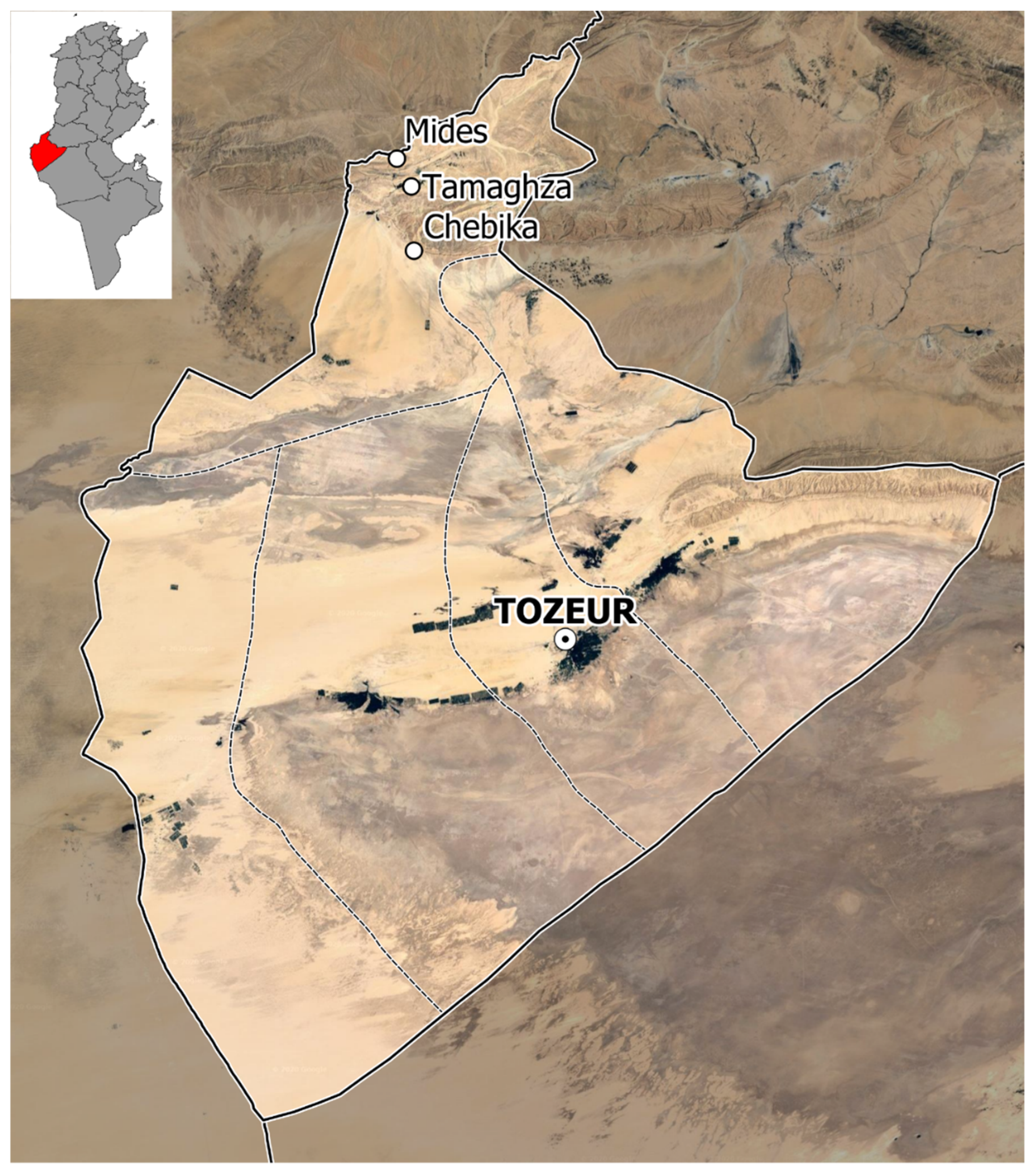
3.1. Land Use and Irrigation System

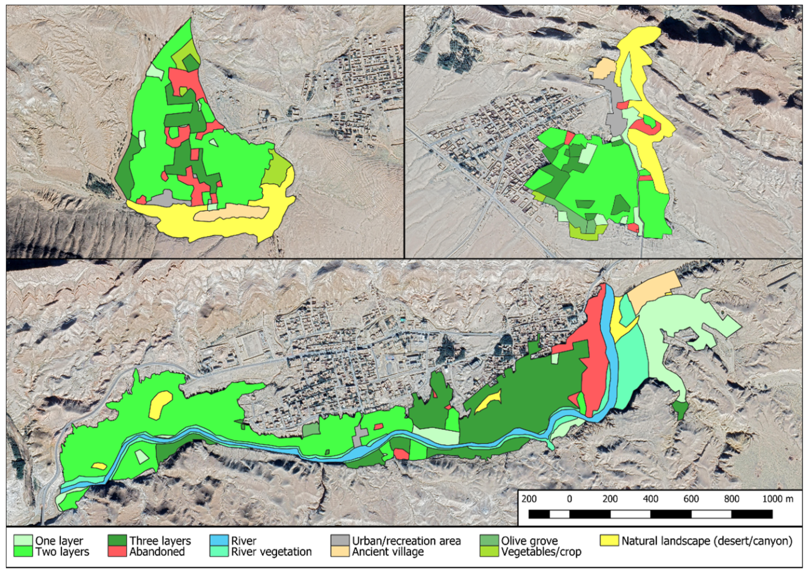
Traditional agricultural activities are still widespread in the three oases, and even if they have a lot of features in common, some differences can be found related to land uses (Table 2 and Figure 2). The two-layer land-use system is the most common typology of cultivation, ranging from 32% in Tamaghza, to 42% in Chebika to 45% in Midès. The three-layer typology is more common in Tamaghza (24%), than in Midès (14%) or Chebika (10%) while the one-layer land-use system can be found mainly in Tamaghza and Chebika (respectively 13% and 10%), but it is rare in Midès (2%). Regarding other types of single cultivations: olives groves are more common in Chebika and are set in the south part, at the border of the oasis facing the desert; herbaceous cultivations (vegetables and fodder) are instead largely cultivated in the eastern part of Midès, facing the canyon, and partly in the north of the oasis where there is also a greenhouse.
Concerning the agricultural surfaces, some parts are affected by abandonment. In Midès, about 4.9 ha (9.4%) are abandoned, especially in the north eastern part and in the central part of the area. The north eastern patch is often used for grazing goats and sheep, so it is still used for traditional activities. A large abandoned patch can be found in Tamaghza, extending for 7.1 ha (6.5%) in the eastern part, while in Chebika the abandonment of traditional agricultural activities is limited to small scattered patches for a total surface of about 1 ha.
All three oases include old abandoned villages. The biggest is in Tamaghza (2.6 ha) and the smallest in Chebika (0.81 ha). The conservation status of the three villages is very diversified, in Chebika eight buildings along the main village path have been restored using traditional techniques and local materials thanks to a project funded by the World Bank, while in Tamaghza only a couple of buildings have been restored [25]. In all three oases, some modern buildings are included inside the borders, and they serve as restaurants/cafés/shops for the tourists visiting the oases. Finally, a significant part of the surface (10.7 ha) of Tamaghza is occupied by the semi-natural vegetation growing along the riverbed.
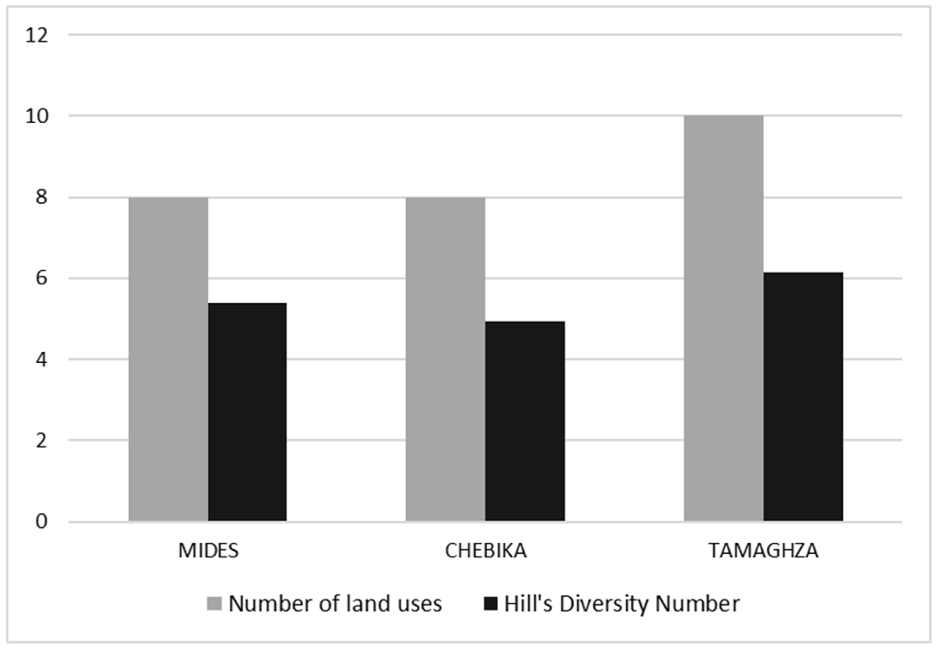
The result of the Hill’s Diversity Number confirms that the situation is similar in the three oases regarding the landscape diversity (Figure 3). The Hill’s Diversity Number varies from 62% to 67% of the total number of land uses.
The irrigation system is fundamental in the function of the oasis system and significant differences have been found related to the management of this resource.
In Midès the territory of the oasis is divided in two parts: a smaller one representing 33% of the surface and a bigger one accounting for 67% of the oasis. According to this division, farmers have water during four days for the smaller part and 10 days for the bigger part, making a whole cycle of 14 days which means that each plot receives water two times per month. The irrigation technique (surface irrigation) is based on the season: in summer, the plots are irrigated day and night, in winter they are irrigated only during the day. Both the traditional old irrigation system and the modern one are used. The old system, while looking mostly abandoned, consists of a network of open channels (locally called seguías) made of concrete and stones. This system is based on big circular wells, but nowadays only a few of these wells are still in use, mainly in the section of the oasis not reached by the modern irrigation system. The modern irrigation system is based on one big pump located at the northern end of the oasis, which pumps the water from 65 m below ground. The water is then made to flow into two main branches at a capacity of 25 L/s. Then the water is distributed to the plots through plastic pipes (20 cm of diameter) which are supposed to be covered with sand (although at the moment they are still mostly exposed), in order to protect them from the direct sunrays or from possible damage caused by people and grazing animals stepping on them. These pipes reach several concrete water tanks. In May 2019, the modern system extended to around 2130 m covering more or less 50% of the parcels, and it was supposed to be completed in the following months. This system already shows several weaknesses due to the construction technique, as a lot of water is wasted through leakages that occur both in the plastic pipe junctions and from cracks in the concrete tanks. Farmers usually pay a fee of about 3 dinars per hour to GDA (Groupement de Développement Agricole) for the electricity that powers the pump. Some temporary ponds for the animals can also be found.
In Chebika, there are two sources of water: a natural spring, Ain Chebika, with an average flow throughout the year equal to 20 L/s, and a pumping well that is connected to a water storage basin built by the GDEO (Gestion Durable des Ecosystèmes Oasiens en Tunisie) project. Traditionally, in Chebika farmers used a local technique, called gadous, developed by the Tunisian historian and Imam Ibn Chabbat (13th century). This system was based on the use of special clay containers (clepsydre) with a hole in the bottom which allows for the dripping of 8 L in 12 min, and the parcels used to be measured by the number of gadous needed to irrigate them. Nowadays, this system is not used anymore, but local people still use the gadous as a measuring system. Actually, a pumping well (Dghima’s well) provide water that is stored in a basin and then distributed to the oasis using concrete channels built in 2015. From these main concrete channels, water reaches the different plots through smaller earth channels. The water from the pumping well is not free for the farmers, as the one from the natural spring, and it works only when the farmers request and pay for the service, while the spring water is free. Therefore, farmers prefer to use the water from the spring, whereas during the dry season when the natural spring water is scarce, they have to ask and pay for water from the pumping well. In recent years, farmers state that they are obliged to ask more often for water from the basin, since natural spring water is becoming scarcer.
Tamaghza is rich in natural water resources which supplies all year-round, as well as seasonal support from dams which replenishes the watershed during dry seasons. The main natural spring feeds four main channels (Targjdeyine, Gholen, Souiguia, Ejjrour) that globally have a flow of 55 L/s. The residual flow in the upstream catchment (the confluence of three Oueds: El Frid, Negueb, some call it El Msalla, and El Brir) feeds other two main channels (Essod, Litaima) giving respectively 42 and 30 L/s. The water flows through gravity on earthen and concrete canals; hence the main water distribution system to the parcels uses zero energy, which is recognized as the main resilience of this traditional system. After a recent flood in 2010 concrete canals substituted the traditional earthen waterways which were washed away. In some areas of the oasis, major landslides created land depressions which requires aqueduct and pipes for delivering the water by preserving the same traditional gravity-based system. In some other cases, farmers had to construct wells in their plots for irrigation, as the traditional gravitational system is no longer possible, and about 50 farmers use generators to pump water to their private plots either from wells or from a lower water stream.
Another important traditional feature of the landscape of the three oases, is the use of a fence to enclose the different plots. Traditional fences are made of dried palm leaves and palm fibres (or iron wire) to tie them together, with palm trunks used as pillars. The fence is normally less than 150 cm high and it can last 15 years with good maintenance. Unfortunately, in the last few years, these beautiful and environmentally sustainable structures have partly been replaced by concrete pillars instead of palm trunks and wire fencing in place of dried palm leaves or as a support for them.

3.2. Agrobiodiversity

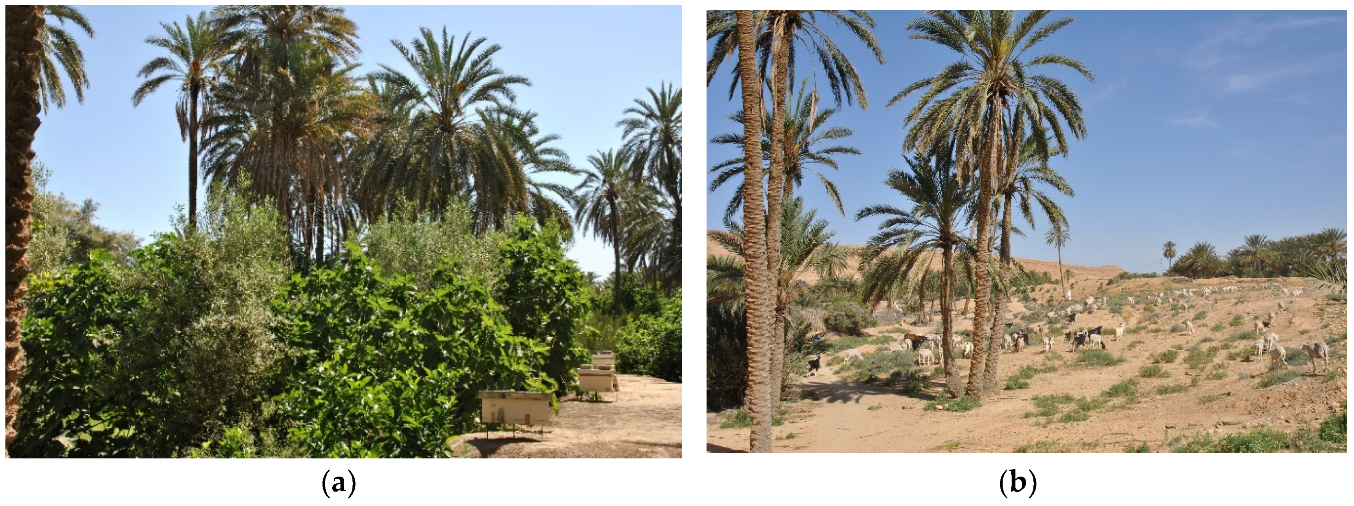
The oasis is typically an area of private smallholdings offering several agricultural productions where date palm, fruit trees and herbaceous plants are strictly connected and shape the landscape. A specific diversity within each oasis, revealed the existence of a larger number of species mainly for the second and third layers, where several fruit trees and vegetable crops species are present. A biodiversity-rich environment offers several opportunities for developing sustainable economic activities at a local level, sustaining human wellbeing and mitigating and adapting to a changing climate since vegetation plays an important role in the maintenance of the agricultural stability in arid regions [29].

3.2.1. First Layer—Date Palm

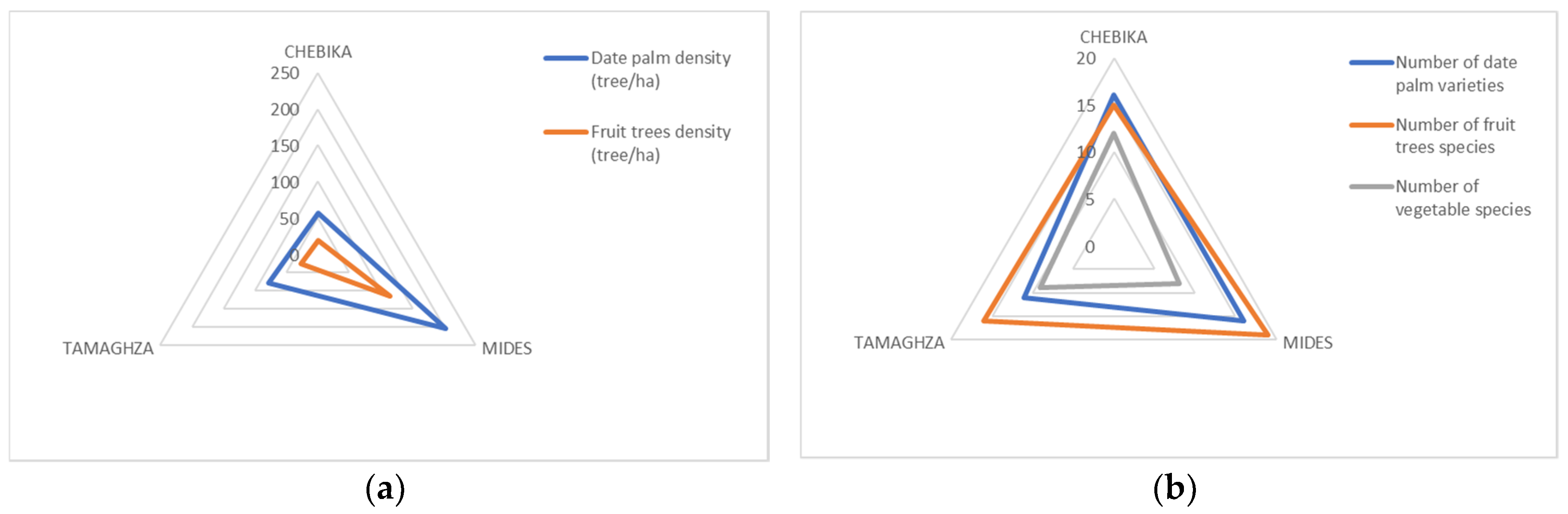
The diversity of palm dates is expressed in terms of varieties, quality and level of maturity. The highest planting density for date palm (Table 3) can be observed in Midès with 203.68 palm/ha, and it has also the highest recovery rate of date palm trees among other oases reaching almost 95%. Chebika oasis has the lowest planting density and consequently the lowest recovery rate.
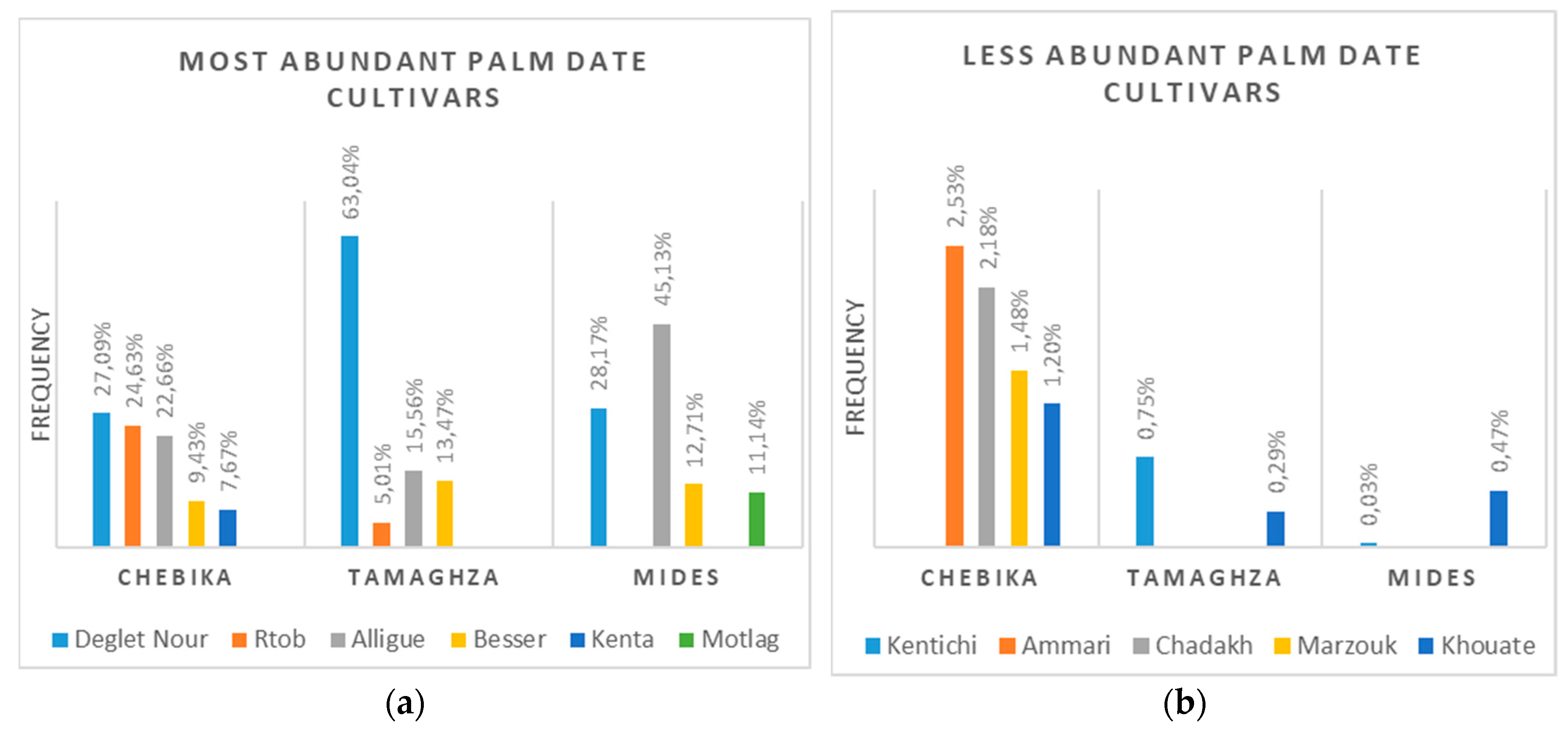
The different cultivated varieties of date palm in the three oases are presented in Figure 4. All the identified varieties show a staggering of the maturation of the different varieties of date palm which begins in August and continues until the month of January. Regarding the quality, dates are classified in dry, half-soft and soft.
In both Midès and Chebika, 16 different date palm varieties have been found. In Chebika, Deglet Nour is the most abundant (27%), followed by Rtob (24%) and Alligue (22%). In Midès the most dominant variety is Alligue (45%) followed by Deglet Nour (28%). Midès is in fact the only oasis in the Djerid where the highest number of palms is represented by a different variety other than Deglet Nour, while in Tamaghza it is far the more common varieties with a frequency of 63%. Alligue and Deglet Nour are therefore the most cultivated varieties, around 15% of farmers are cultivating one of these two varieties, while 31% are cultivating both because of the rejuvenation program implemented a few years ago.
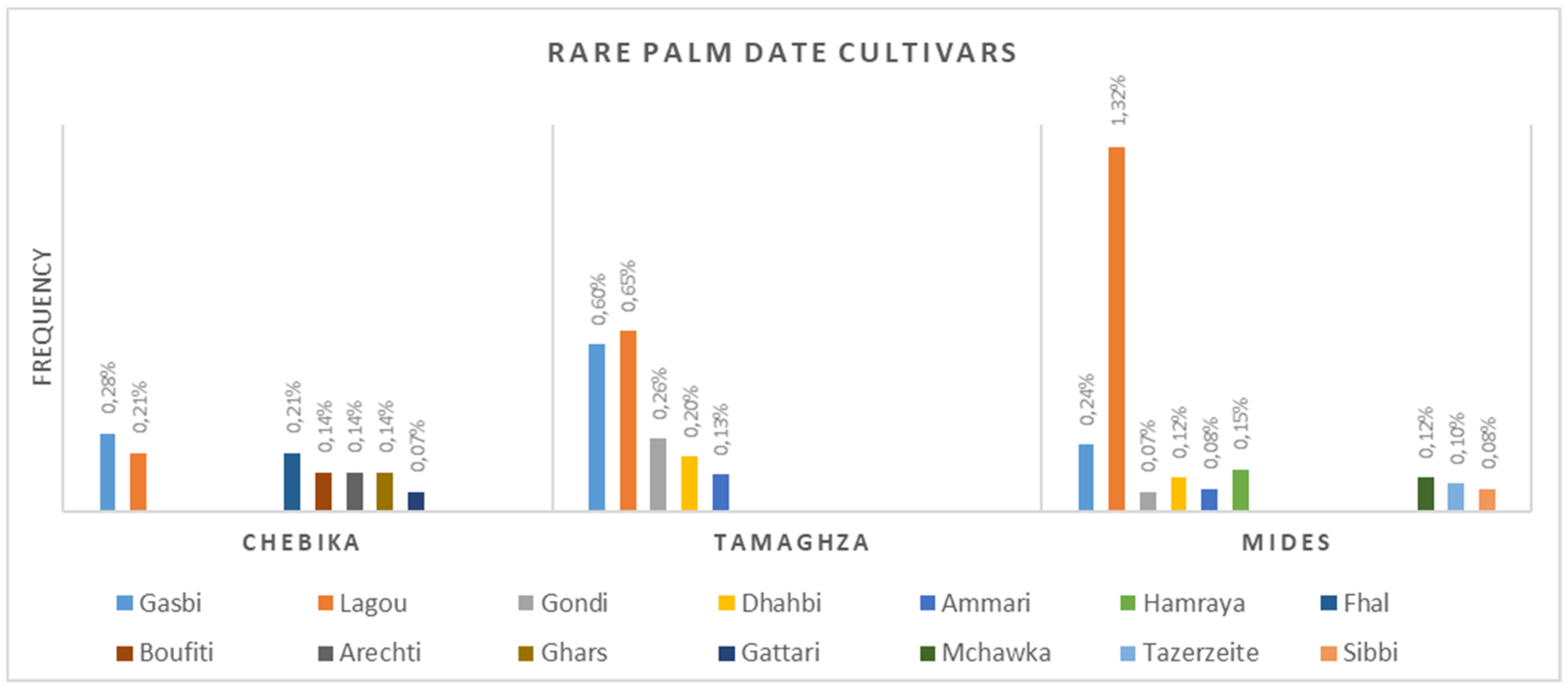
Added to the above-mentioned varieties, some other varieties (Figure 5) are still present for their symbolic value as almost the majority of farms were inherited. These rare palm trees, represented by only one or a few trees, are usually called Khalte (or Chaken), which, according to Rhouma [30], designates a palm tree resulting from sowing and multiplied by vegetative reproduction. Although they are now very rare, their presence is however important as a genetic and agrobiodiversity reservoir.

3.2.2. Second Layer—Fruit Trees

More than 20 varieties of date palm that are harmoniously associated with many trees and plants cultivated in the other two layers have been identified. In the three oases, 21 species of fruit trees have been identified (Table 4).
The combination of crops, their distribution, the frequency of each species and their state of dominance depends on several parameters such as the vocation of the region, climatic conditions, farmers’ commitments, expectations and knowledge.
With a high recovery rate, Midès is the oasis that has shown the most important number of fruit tree species, while the lowest was noticed in Tamaghza. Species’ diversity is more accentuated and well-marked in Midès than in Chebika and Tamaghza, where more than 30% of farmers have more than five species of fruit trees in their parcels. Midès has higher number of trees and higher planting density.
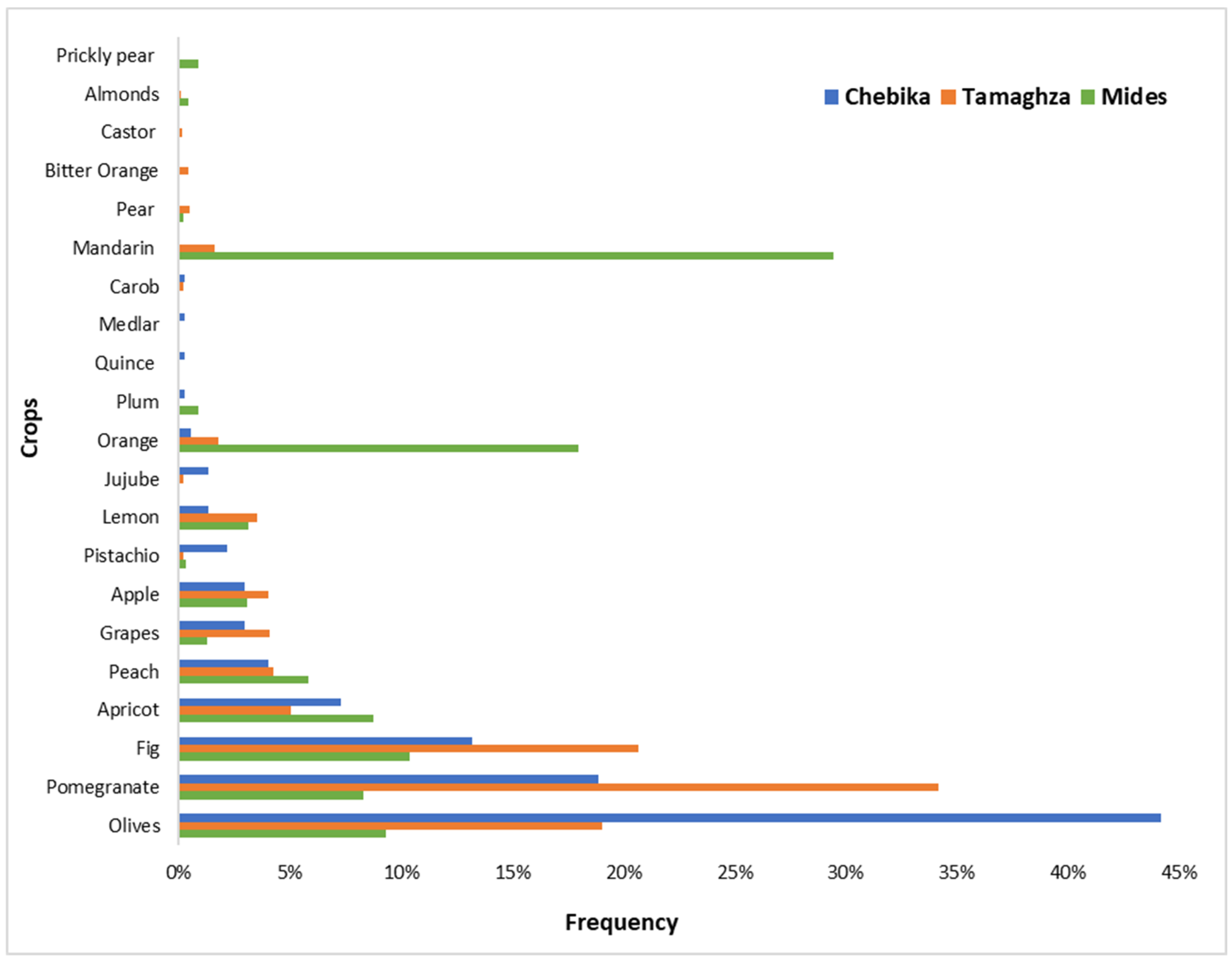
The presence of different fruit trees deeply characterizes the second layer of the three oases; even if olives, pomegranates and figs are the most common species, there are important differences between the three oases (Figure 6). The dominant species in Tamaghza and Midès are pomegranates and citrus respectively (mainly mandarin and orange), while in Chebika the most abundant fruit tree is the olive, with a frequency reaching almost 45% not only cultivated as second layer, but also as the main crop since there are parcels completely devoted to olive groves. Other species, such as apricot, peach, grapevine and apple, are also cultivated, but with lower frequencies. Some other fruit species are planted for purposes other than consumption, such as the case of the prickly pear in Midès that is used also as a fence for the delimitation of different properties and parcels. Many local varieties and species are identified and replanted, but others are disappearing, such as almonds in Midès.
The high level of agrobiodiversity related to fruit trees cultivation is not only due to the number of different species, but also to the high number of fruit tree varieties, and therefore a significant genetic diversity is preserved in the agricultural system of traditional mountain oases (Table 5).

3.2.3. Third Layer—Vegetables and Fodder

The third layer is particularly important for the livelihood of the local communities, as it provides various vegetables for family consumption and fodder for animals. 21 vegetable species and two fodder crops are cultivated in Midès, Tamaghza and Chebika (Table 6). Furthermore, indigenous varieties of seeds continue to be stored and planted, thanks to home conservation of seeds, firmly supporting the unique food culture that is also considered a regional attraction. The local crops found in the oases are mainly peppers (Midès), pumpkins (Midès), onions, chard, lettuce (Chebika), parsley, jute mallow (Chebika), okra (Chebika). Midès seems to be the oasis with the highest recovery rate of vegetables (13.8%), and in fact, it is known for the production of a specific chili pepper variety, cultivated by many farmers.
Forage crops, mainly alfalfa and barley, are also present in the mountain oases, as most of farmers are also breeders.
Aromatic and medicinal plants are also present in the mountain oases, such as Jasminum Sambac, Jasminum officinale, Lawsania inermis, Ricinus communis, Laurus nobilis, Rosa damascena, Mentha spicata, Mentha suaveolens, Ocimum basilicum, Pelargonium graveolens, Vitex agnus-castus.

3.2.4. Animal Husbandry

Breeding is a fundamental traditional activity for the oases production system. Sheep, goats and camels are present, and these animals can be found sometimes inside the oasis and sometimes in the surrounding areas, such as at the sides of the riverbed, where spontaneous cane grows. In the Tozeur region different breeds of goats (Serti, Arbi, Damasquine, Alpine) characterized by a high polymorphism [31] can be found. In addition, apiculture was recently introduced in the oases, especially in Midès (Figure 7).

4. Discussion

The richness of biodiversity has always characterized these oases, which represent an agroecosystem where local varieties are adapted to a difficult environment [32,33,34,35], with the main restrictions due to climate and extreme temperatures, and to water availability and quality. For centuries, local farmers planted different species and varieties to obtain food and resources for themselves and their families, maintaining the most productive ones at the expense of the ones that produced less or that proved to be not enough resistant to the environmental conditions. They used to plant different species and varieties to ensure the production even during changing environmental conditions, pests or diseases. Therefore, the mountain oases of Tunisia are good examples of how traditional knowledge and agricultural practices and specific environmental conditions have largely contributed to the preservation of high agrobiodiversity [36]. The presence of high levels of agrobiodiversity is a primary source for meeting social needs and a basis for adapting to climate change.
The areas under examination can be considered a good example of agrobiocultural diversity at landscape level. Although they are characterized by a limited number of land uses, they are complex and rich agroecosystems. The study of the spatial landscape structure is of crucial importance for assessing and monitoring biodiversity [37], and in these agroforestry systems is also important to understand biocultural diversity, as spatial diversity in rural landscapes depends on human activities [38]. In contrast to traditional landscapes located in the European part of the Mediterranean basin [39], the mountain oasis of Chebika, Midès and Tamaghza are not among the traditional agricultural systems that are at risk of disappearing. Here, traditional agriculture practices are still an important part of the local economic system, although there are some processes of transformation currently underway that could potentially affect the level of agrobiodiversity. In particular, consumer demand for some specific varieties could lead to the replacement of traditional and local varieties with more productive ones [12].
Three main typologies of land uses are present in the area: agricultural, urban and natural. The most widespread land uses in all the three oases are the ones related to farming activities, with percentages equal to 74%, 85% and 69% for Midès, Tamaghza and Chebika respectively. The other land uses are, however, important features of the oases. Urban areas include the ancient villages, while the natural areas involve the combination of canyons, desert and mountains that enrich the aesthetical value of the sites (Figure 8).
The biodiversity richness of the three oases is generally high. The three-layer cultivation system creates diverse microclimates inside the traditional oases, particularly important also for biodiversity related to spontaneous herbaceous species and with positive effects on wildlife richness and abundance [40,41]. The results of the surveys confirm that many varieties of date palm and fruit trees, as well as different kind of vegetables are present throughout. In the mountain traditional oases, many local date varieties are still cultivated, revealing a great diversity in comparison with other Tunisian oases. This is particularly important, considering that nowadays new plantations in Tunisian oases are made up of almost 100% Deglet Nour, at the expense of traditional, albeit less commercially desirable, varieties. Additionally, in some traditional oases too, local varieties are being replaced by Deglet Nour. Moreover, the Deglet Nour variety represents 66.17% of the total number of palms in the old oases of the Djerid region [24], and 45% and 60% of all Algerian and Tunisian date palm orchards, respectively [12]. However, in the three mountain oases the presence of this variety is still lower, with an average of 43.9% (Figure 4).
The comparison of some of the indices highlights the differences between the three oases (Figure 9). Midès has significantly higher values of tree density, both for date palms and for fruit trees. This is also confirmed from the land-use structure, as in Midès where the one-layer cultivation system is limited to about 2% of the total surface. Midès is also the oasis with the highest number of date palm varieties (the same of Chebika) and of fruit tree species. In contrast, Chebika has the highest number of vegetable species, while Midès has the lowest. This is probably due to the fact that a smaller number of people live in the town of Midès and that they are more dedicated to animal breeding than to vegetable cultivation, while in Chebika animal breeding is less common.
Among the three oases, Midès has the highest recovery rate with 167, while lower values are calculated for Tamaghza and Chebika, respectively equal to 104 and 106 (Table 7). Because of the multilayered agroecosystem, these values exceed 100%. This above average level of agrobiodiversity in the mountain oases of Tunisia is consistent with that observed in traditional oases in other countries. For example, in three small traditional oases in the northern mountains of Oman, 14–17 different date palm cultivars and a total of 107 different plant species have been recorded [42].
The main threats to the maintenance of the multilayered oases landscape can be found in socio-economic driving forces. The aging of the population of farmers, and the fact that in the past decades young people moved to bigger cities to find better work opportunities, can lead to the abandonment of traditional agricultural practices and traditional but less economically attractive date palm cultivars. It must be noticed that since the economic situation of Tunisia has worsened in recent years even in the bigger cities, the internal migration decreased and today many young people still live in the villages. Regarding the irrigation system, recent improvements, such as the use of plastic pipes to provide water to all the parcels inside the oases, can have negative effects if not properly managed. The fact that the black pipes have not been covered by sand as expected, has a negative impact on the landscape, and at the same time reduces their effectiveness as pipes are more subject to damages caused by sunrays and wild boars. Wild boars are also a significant threat to the lower cultivation layer.
Another threat comes from the spread of Deglet Nour. Traditional date palm production is based on thousands of distinct varieties exhibiting a wide range of adaptation, growth habit and fruit characteristics. There is no clarity on the total number of varieties of dates currently cultivated in the world, but according to recent reports this number range from 1500 to 5000 approximately, while for Tunisia are reported about 250 varieties [12]. Despite these high numbers, in Tunisia, in the last decades significant investments in modern plantations have led to a steady increase in exports [43], but also to a replacement of local varieties with Deglet Nour monocultures. Today, Tunisia is the world-leading producer of Deglet Nour, accounting for approximately 50% of the world’s Deglet Nour palm trees. The official production in 2001 was equal to 107,000 tons for all varieties, of which about two-thirds are Deglet Nour [43].
In the three surveyed oases, tourism plays an important role for the local community in terms of the income and employment created. However, the post-revolution years (after 2011) have brought economic uncertainty, with negative influence on the national tourism sector, affecting these sites. Fortunately, in the last few years, the sites’ peaceful character has reinforced the perception of these oases as an ideal place for rest and relaxation, and together with the rich natural and cultural landscape, has attracted a growing number of tourists.

5. Conclusions

Traditional oases, as with other traditional agroforestry and agricultural heritage systems, continue to play a vital role in the maintenance and enrichment of genetic resources and agrobiodiversity multiple processes and dynamic conservation practices. Local varieties of cultivated species are the products of centuries of interaction between farmers, the genetic and breeding systems, and the environment, often presenting outstanding adaptation to climatic, edaphic, and management factors. Traditional oases are therefore important biodiversity hotspots, where the maintenance of traditional agricultural practices is fundamental for agrobiodiversity preservation.
Traditional date palm farmers in these oases and in other countries, practice de facto a real conservation of genetic resources and genetic diversity by maintaining traditional cultivars, especially in traditional oases [12]. Since the role of the farmers is fundamental in preserving the agrobiodiversity of traditional oases, it is important to guarantee a sufficient income, not only through the valorization of different date cultivars and byproducts on the market, but also promoting sustainable rural tourism.
The genetic diversity of the date palm and of the other crops in the oases is a key feature for the resilience of these sustainable agroforestry systems towards future changes in global climate, markets, and other socio-economic pressures. Therefore, it is important to ensure that the wide range of existing varieties and species is not further reduced, by avoiding the spread of monocultures and preserving the traditional oases related knowledge, as the importance of these agroecosystems is not solely due to agricultural production, but also to their multifunctional role in preserving traditional knowledge, agrobiodiversity, as well as the cultural and landscape heritage. Ancillary activities, such as animal breeding and beekeeping, can be important both for biodiversity and for the economy of local farmers. International programmes, such as the GIAHS programme of the Food and Agricultural Organization, can play a key role in preserving traditional agricultural systems, and the related agrobiodiversity. The FAO GIAHS programme in fact is based on the concept of dynamic conservation, as the preservation of agricultural heritage systems must not correspond to the static conservation. Improvements to farmers’ quality of life thanks to innovations that respect the traditional features, such as a more efficient irrigation system or better market opportunities for local products, help to maintain these systems that can also represent examples of resilience and adaptability towards new global challenges, such as climate change.
This study has carried out an accurate analysis of the landscape structure and of the agrobiodiversity in three traditional oases of Tunisia, with the intent of creating a database for future monitoring, in order to understand and measure possible transformations and evaluate the best strategies to preserve these agricultural heritage systems. The combined assessment of land uses and agrobiodiversity can represent a methodology to be replicated in other agroforestry or agricultural heritage systems. Finally, results show that the three oases have all the characteristics required to be considered as potential GIAHS sites.

Author Contributions

Conceptualization, A.S.; methodology, A.S., F.B., S.B.M., F.C. and M.V.; software and analysis, F.P., F.B. and A.S.; writing, A.S., F.B., S.B.M., F.P., F.C. and M.V.; supervision, M.A. and A.S. All authors have read and agreed to the published version of the manuscript.

Funding

This research is part of the “GIAHS Building Capacity” project, funded by the Italian Agency for Development Cooperation (AICS) and by the Department of Agriculture, Food, Environment and Forestry (DAGRI) of the University of Florence. All authors have read and agreed to the published version of the manuscript.

Acknowledgments

The authors want to thank the students of the Agricultural Heritage Systems master course 2018–2019 of the University of Florence and all the population of Midès, Chebika and Tamaghza for sharing their knowledge.

Conflicts of Interest

The authors declare no conflicts of interest.

References

  1. Wei, W.; Chen, D.; Wang, L.; Daryanto, S.; Chen, L.; Yu, Y.; Lu, Y.; Sun, G.; Feng, T. Global synthesis of the classifications, distributions, benefits and issues of terracing. Earth-Sci. Rev. 2016, 159, 388–403. [Google Scholar] [CrossRef] [Green Version]
  2. Price, S.; Nixon, L. Ancient Greek agricultural terraces: Evidence from texts and archaeological survey. Am. J. Archaeol. 2005, 109, 665–694. [Google Scholar] [CrossRef]
  3. Capistrano, A.D.; Marten, G.G. Agriculture in Southeast Asia. In Traditional Agriculture in Southeast Asia: A Human Ecology Perspective; ITDG Publishing: Rugby, UK, 1986; pp. 6–8. [Google Scholar]
  4. Healy, P.F.; Lambert, J.D.; Arnason, J.T.; Hebda, R.J. Caracol, Belize: Evidence of ancient Maya agricultural terraces. J. Field Archaeol. 1983, 10, 397–410. [Google Scholar] [CrossRef]
  5. Edelstein, G.; Kislev, M. Mevasseret Yerushalayim: The ancient settlement and its agricultural terraces. Biblic. Archaeol. 1981, 44, 53–56. [Google Scholar] [CrossRef]
  6. Parrotta, J.A.; Agnoletti, M. Traditional forest-related knowledge and climate change. In Traditional Forest-Related Knowledge; Springer: Dordrecht, The Netherlands, 2012; pp. 491–533. [Google Scholar]
  7. Onofre, S.A. The floating gardens in México Xochimilco, world heritage risk site. City Time 2005, 1, 5. [Google Scholar]
  8. Islam, T.; Atkins, P. Indigenous floating cultivation: A sustainable agricultural practice in the wetlands of Bangladesh. Dev. Pract. 2007, 17, 130–136. [Google Scholar] [CrossRef] [Green Version]
  9. Coe, M.D. The chinampas of Mexico. Sci. Am. 1964, 211, 90–99. [Google Scholar] [CrossRef]
  10. Battesti, V. Jardins au désert: Évolution des Pratiques et Savoirs Oasiens: Jérid Tunisien; IRD éditions: Paris, France, 2005. [Google Scholar]
  11. De Haas, H. Migration and Agricultural Transformations in the Oases of Morocco and Tunisia; KNAG: Utrecht, The Netherlands, 2001. [Google Scholar]
  12. Jaradat, A.A. Biodiversity of Date Palm. Encyclopedia of Life Support Systems: Land Use, Land Cover and Soil Sciences; Eolss Publishers: Oxford, UK, 2011; Volume 31. [Google Scholar]
  13. Ministère de l’environnement et du développement durable. Elaboration d’une Monographie Complete des Oasis en Tunisie. Document 2: Identification et Caracterisation des Oasis en Tunisie; Direction générale de l’environnement et de la qualité de la vie: Tunis, Tunisia, 2015. [Google Scholar]
  14. Lasram, M. Les systèmes agricoles oasiens dans le Sud de la Tunisie. In Les Systèmes Agricoles Oasiens. Options Méditerranéennes; Dollé, V., Toutain, G., Eds.; (Série A. Séminaires Méditerranéens n. 11); CIHEAM: Montpellier, France, 1990; pp. 21–27. [Google Scholar]
  15. Tisserand, J.-L. Les Ressources Alimentaires pour le Bétail. Les Systèmes agricoles oasiens. In Options méditerranéennes; (Série A. Séminaires Méditerranéens n. 11); CIHEAM: Paris, France, 1990. [Google Scholar]
  16. Bourzat, D.; Goe, M.R. L’animal, force de travail dans les systèmes oasiens. In Les Systèmes Agricoles Oasiens. Options Méditerranéennes; Dollé, V., Toutain, G., Eds.; (Série A. Séminaires Méditerranéens n. 11); CIHEAM: Montpellier, France, 1990; pp. 249–260. [Google Scholar]
  17. Nair, P.R. An Introduction to Agroforestry; Kluwer Academic Publisher: Dordrecht, The Netherlands, 1993. [Google Scholar]
  18. Ministère de l’environnement et de developpement durable. Stratégie de Développement Durable des Oasis en Tunisie; Direction générale de l’environnement et de la qualité de la vie: Tunis, Tunisia, 2015. [Google Scholar]
  19. Belarbi, A.; Bouayad, A.; Diaou, M.; Kaassis, N.; Maliki, M.T. Agrobiodiversity and Sustainability of Oasis Production Systems in the Palm Groves of Aoufouss, Errachidia, Morocco; (Serie de Documents de Travail-Agropolis International, (121)); Agropolis International: Montpellier, France, 2004. [Google Scholar]
  20. McNeely, J.A.; Gadgil, M.; Levèque, C.; Padoch, C.; Redford, K. Human influences on biodiversity. In Global Biodiversity Assessment; Heywood, V.H., Watson, R.T., Eds.; Cambridge University Press: Cambridge, UK, 1995; pp. 711–821. [Google Scholar]
  21. FAO. Background Paper 1. Agricultural Biodiversity. In Proceedings of the Multifunctional Character of Agriculture and Land Conference, Maastricht, The Netherlands, 12–17 September 1999. [Google Scholar]
  22. Koohafkan, P.; Altieri, M.A. Globally Important Agricultural Heritage Systems. A Legacy for the Future; Food and Agriculture Organization of the United Nations: Rome, Italy, 2011. [Google Scholar]
  23. Friedman, L.; Marcus, B. Architecture and Ecosystem of the Oasis: Towards a Conservation Plan for a Tunisian Cultural Landscape. Available online: www.academia.edu/download/6005433/CSAAR_2008_Tunisian_Oases__paper.pdf (accessed on 10 March 2020).
  24. Ginex, G. Incroci morfologici: Tre città-oasi a sud della Tunisia. In 1 Congresso Internazionale “Il Progetto di Architettura fra Didattica e Ricerca”; Polibapress: Bari, Italy, 2011; pp. 2–6. [Google Scholar]
  25. INS - Institut National de la Statistique. Rapport du Recensement Général de la Population et de l’Habitat; RGPH2014; INS: Tunis, Tunisia, 2015. [Google Scholar]
  26. Hill, M.O. Diversity and evenness: Unifying notation and its consequences. Ecology 1973, 54, 427–432. [Google Scholar] [CrossRef] [Green Version]
  27. Maachia, S.B.; Othmani, A.; Jemni, M.; Khaldi, R. Rapport d’avancement de la mission de CRRAO Degache "Appui spécifique avec activités de protection de la biodiversité oasienne menées par des institutions de recherche spécialisées"; Ministère de l’Agriculture, des Ressources hydrauliques et de la Pêche, Institution de la Recherche et de l’Enseignement Supérieur Agricoles, Centre Régional de Recherches en Agriculture Oasienne à Deugache: Deugache, Tunisia, 2016. [Google Scholar]
  28. Braun-Blanquet, J. Plant Sociology (Transl. G. D. Fuller and H. S. Conrad); McGraw-Hill: New York, NY, USA, 1932; p. 539. [Google Scholar]
  29. Hamza, H.; Elbekkay, M.; Mahmoudi, K.; Kadhi, M.S.B.; Ferchichi, A. Mesure de l’état de la biodiversité dans les oases de Kébili; Institut des régions arides: Medenine, Tunisia, 2006. [Google Scholar]
  30. Rhouma, A. Le palmier dattier en Tunisie, I. In Le Patrimoine Génétique; IPGRI, UNDP, GEF/FEM, INRAT: Rome, Italy, 2005; Volume 2. [Google Scholar]
  31. Nafti, M.; Khaldi, Z.; Rekik, B.; Ben Gara, A. Biodiversity in goats in the Tunisian oasis. Available online: https://www.researchgate.net/profile/Khaldi_Zahrane/publication/261793386_Biodiversity_in_goats_in_the_Tunisian_oasis/links/00b7d5357b7e4734c6000000.pdf (accessed on 6 March 2020).
  32. Elshibli, S.; Korpelainen, H. Identity of date palm (Phoenix dactylifera L.) germplasm in Sudan: From morphology and chemical characters to molecular markers. Acta Hortic. 2010, 859, 143–153. [Google Scholar] [CrossRef]
  33. Elshibli, S.; Korpelainen, H. Microsatellite markers reveal high genetic diversity in date palm (Phoenix dactylifera L.) germplasm from Sudan. Genetica 2008, 134, 251–260. [Google Scholar] [CrossRef] [PubMed]
  34. Salah, M. Ben, Agro-biodiversity and Traditional Knowledge on Tunisian Coastal Oases. J. Environ. Sci. Eng. 2011, 5, 303–308. [Google Scholar]
  35. Battesti, V.; Gros-Balthazard, M.; Ogéron, C.; Ivorra, S.; Terral, J.F.; Newton, C. Date Palm Agrobiodiversity (Phoenix dactylifera L.) in Siwa Oasis, Egypt: Combining Ethnography, Morphometry, and Genetics. Hum. Ecol. 2018, 46, 529–546. [Google Scholar] [CrossRef]
  36. Habib, A.; Maachia, S.B.; Sahli, A.; Slimane, M.H.-B. Salt stress responses of six grapevine genotypes from the oases of Tozeur. Tunis. J. Plant Prot. 2019, 14, 1–16. [Google Scholar]
  37. Tilman, D. Competition and biodiversity in spatially structured habitats. Ecology 1994, 1, 2–16. [Google Scholar] [CrossRef]
  38. Agnoletti, M.; Tredici, M.; Santoro, A. Biocultural diversity and landscape patterns in three historical rural areas of Morocco, Cuba and Italy. Biodivers. Conserv. 2015, 24, 3387–3404. [Google Scholar] [CrossRef]
  39. Terres, J.M.; Scacchiafichi, L.N.; Wania, A.; Ambar, M.; Anguiano, E.; Buckwell, A.; Coppola, A.; Alexander Gocht, A.; Nordström Källströmg, H.; Pointereau, P.; et al. Farmland abandonment in Europe: Identification of drivers and indicators, and development of a composite indicator of risk. Land Use Policy 2015, 49, 20–34. [Google Scholar] [CrossRef]
  40. Selmi, S.; Boulinier, T. Breeding bird communities in southern Tunisian oases: The importance of traditional agricultural practices for bird diversity in a semi-natural system. Biol. Conserv. 2003, 110, 285–294. [Google Scholar] [CrossRef]
  41. Pimentel, D.; Stachow, U.; Takacs, D.A.; Brubaker, H.W.; Dumas, A.R.; Meaney, J.J.; O’Neil, J.A.S.; Onsi, D.E.; Corzilius, D.B. Conserving biological diversity in agricultural/forestry systems. BioScience 1992, 42, 354–362. [Google Scholar] [CrossRef]
  42. Gebauer, J.; Luedeling, E.; Hammer, K.; Nagieb, M.; Buerkert, A. Mountain oases in northern Oman: An environment for evolution and in situ conservation of plant genetic resources. Genet. Resour. Crop. Evol. 2007, 54, 465–481. [Google Scholar] [CrossRef]
  43. Liu, P. The marketing potential of date palm fruits in the European market. In Fao Commodity and Trade Policy Research Working Paper n.6; FAO: Rome, Italy, 2003. [Google Scholar]
Figure 1. Localization of the three mountain Oasis in the Tamaghza Delegation, Tozeur Governorate.
Sustainability 12 04054 g001
Figure 2. Land-use maps of the mountain oases of Midès (top left), Chebika (top right) and Tamaghza (bottom).
Sustainability 12 04054 g002
Figure 3. Number of land uses and Hill’s Diversity Number for the three mountain oases.
Sustainability 12 04054 g003
Figure 4. Most abundant (a) and less abundant (b) date palm varieties in the three mountain oases.
Sustainability 12 04054 g004
Figure 5. Rare date palm varieties in the three mountain oases.
Sustainability 12 04054 g005
Figure 6. Fruit trees frequency in the three oases.
Sustainability 12 04054 g006
Figure 7. Beehives near fruit trees (a) and goats (b) in Midès.
Sustainability 12 04054 g007
Figure 8. Three-layer cultivation with date palm, fruit trees and fodder in Midès (a), vegetable gardens plots in Chebika (b), Chebika oasis seen from the mountain (c) and Midès oasis seen from the main road of the new village (d).
Sustainability 12 04054 g008
Figure 9. Comparison between date palm and fruit tree density (a) and number of date palm varieties, fruit tree species and vegetable species (b).
Sustainability 12 04054 g009
Table 1. Total population and farmers in the three mountain oases [25].
MIDÈSTAMAGHZACHEBIKA
MalesFemalesMalesFemalesMalesFemalesTotal
Total population--11401189591597
750 (120 families)2329 (589 families)1188 (227 families)4267
Farmers----10016
70300116486
Table 2. Land uses of the three oasis in hectares and percentages.
LAND USECHEBIKAMIDÈSTAMAGHZA
ha%ha%ha%
Abandoned land1.073.56%4.909.41%7.086.53%
Ancient village0.812.69%1.993.82%2.602.40%
One-layer cultivation (palm trees)3.0110.01%0.981.88%13.8612.78%
Two-layer cultivation12.5541.72%23.4445.03%34.8932.17%
Three-layer cultivation3.0610.17%7.2613.95%26.5124.45%
Herbaceous crops (vegetables/fodder)0.792.63%2.584.96%--
Olive grove1.013.36%--0.460.42%
Natural landscape (desert/canyon)6.1520.45%9.9019.02%2.872.65%
River----8.968.26%
River vegetation----10.729.89%
Urban/recreation area1.635.41%1,001.92%0.490.45%
TOTAL (ha)30.0852.05108.44
Table 3. Main characteristics of date palm cultivation in the three mountain oases.
CHEBIKAMIDÈSTAMAGHZA
Number of date palms142159076193
Planting density (palm/ha)56.84203.6877.41
Recovery rate76.6294.6487.32
Table 4. Main characteristics of fruit trees cultivation in the three mountain oases.
CHEBIKAMIDÈSTAMAGHZA
Number of fruit trees38731642309
Planting density (tree/ha)18.77115.0526.65
Recovery rate12.2857.4511.36
Number of fruit tree species151916
Most frequent speciesOliveCitrusPomegranates
Table 5. Different varieties of the different fruit trees commonly cultivated in the three mountain oases.
Common NameScientific NameVarieties
Olive treeOlea europeaChemchali (Gafsi), Zarrzari, Arbi, Neb, Chemlali (Sahli)
Pomegranate treePunica granatumGarci, Tounsi, Gabsi, Arbi, Khadhraya, Ballahi
Fig treeFicus caricaTounsi, Zidi, Saoudi, Tasiret, Boujeldane, Bither Abyeth, Khalte Hamraya Tamaghza, Khalte Tamaghza, Zag Tire, Abdelhafidh Midès, Khalte Chaieb, Khalte Khdhari, Khalte Hawachia
Apricot treePrunus rosaceaeArbi (Bargoug), Badri/Louzi, Bayadhi, Grafted,
Peach treePrunus persicaBouchouka, Arbi, Arbi Bedri, Arbi Bedri 2, Bedri, Arbi Kherfi,
GrapevineVitis viniferaKahla, Meski, Arbi, Souadi
Apple treeMalus domesticaArbi
PistachioPistachia lentiscus-
Lemon treeCitrus limonArbi, lim beldi, 4 seasons,
Jujube treeZiziphus mauritanius-
Orange treeCitrus sinensisThomson, Clementine
Bitter OrangeCitrus aurantum-
Plum treePrunus domesticaBidha, Hamra
Quince treeCydonia oblonga-
Medlar treeEriobotrya japonica-
Carob treeCeratonia siliqua-
Mandarin treeCitrus reticulata-
Pears treePyrus communus-
CastorRicinus communis-
Almond treePrunus dulcis-
Prickly pearOpuntia ficus-indica-
Banana (only in Chebika)Musa paradisiaca-
Table 6. Different vegetables and fodder species.
ChebikaMidèsTamaghza
Number of vegetable species1289
Most frequent vegetablesOnions-Chili PepperChili pepperChard–Chili pepper
Vegetables recovery rate4.3113.810.2
Different vegetablesChard, Parsley, Lettuce, Onions, Jute Mallow, Carrot, Chili Pepper, Broad Bean, Tomatoes, Okra, Cucumber, Eggplant, Garlic, Fenugreek, Pumpkin, Turnip, Potato, Galia Melon, Honeydew Melon, Radish, Bay Laurel
FodderAlfalfa–Barley
Fodder recovery rate12.51.35.48
Table 7. Total Specific Richness and Total Recovery Rate for the three oases.
ChebikaMidèsTamaghza
Total Specific richness303129
Total Recovery rate105.71167.2104.36

