Landscape Design as a Tool to Reduce Soil Salinization: The Study Case of Keriya Oasis (NW China)


Abstract
1. Introduction
2. Methodology
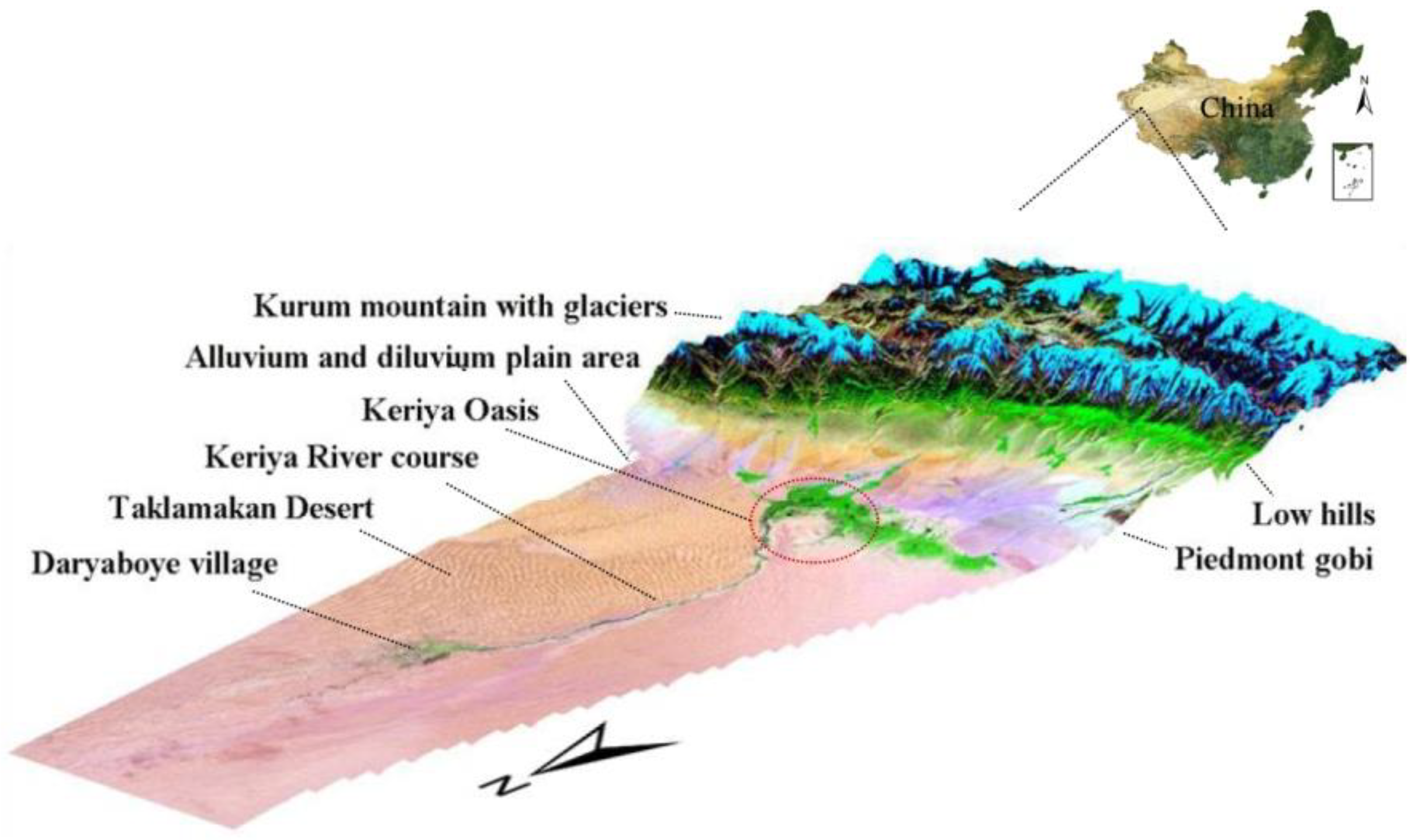
2.1. Study Area
2.2. Methods
2.2.1. Spatial Hydro-Geological Map
2.2.2. Cross Section of Hydro-Geological Model
2.2.3. Drainage System and Groundwater Balance Model
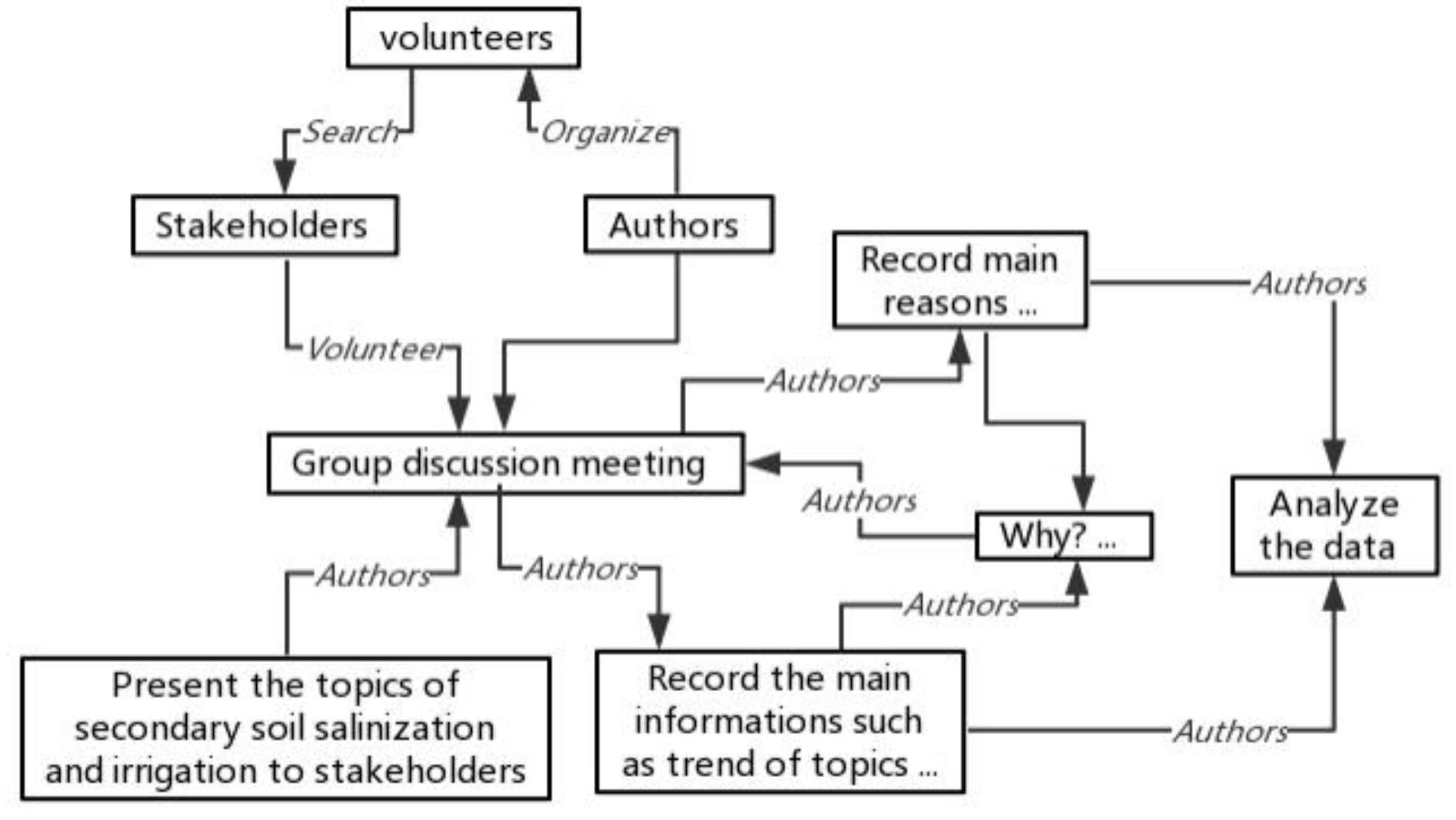
2.2.4. Stakeholders’ Opinions and Attitudes Towards the Design
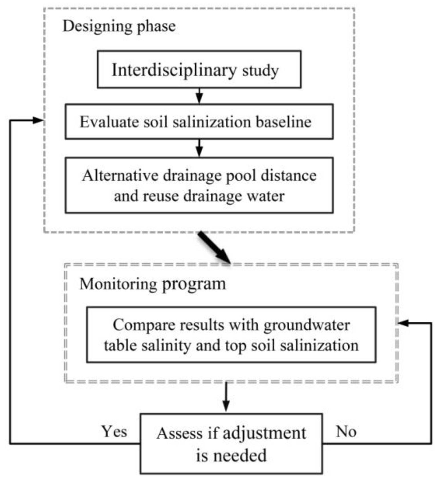
2.2.5. AdaptiveDesalinization Strategy
3. Results
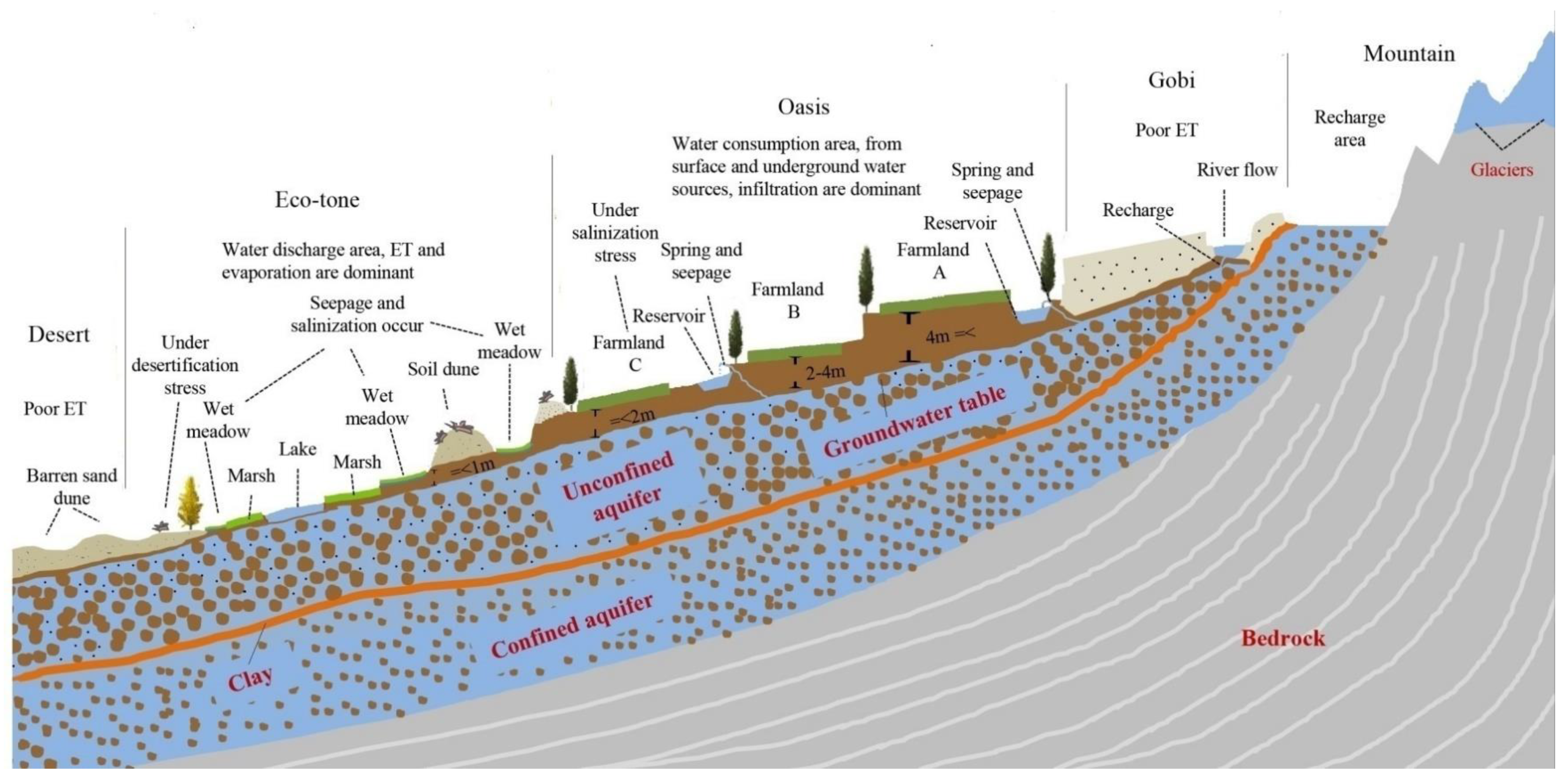
3.1. Conceptual Scheme of the Hydro-Geological Model
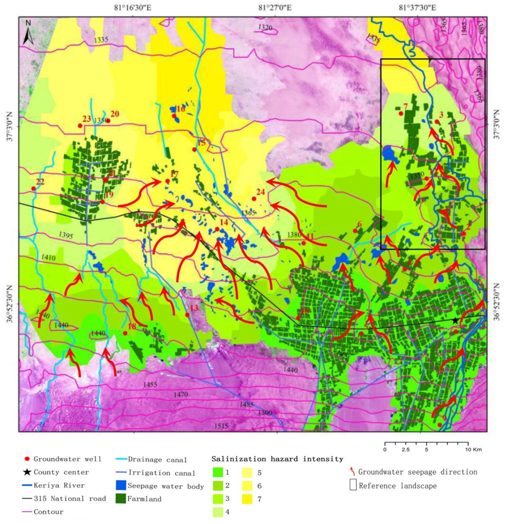
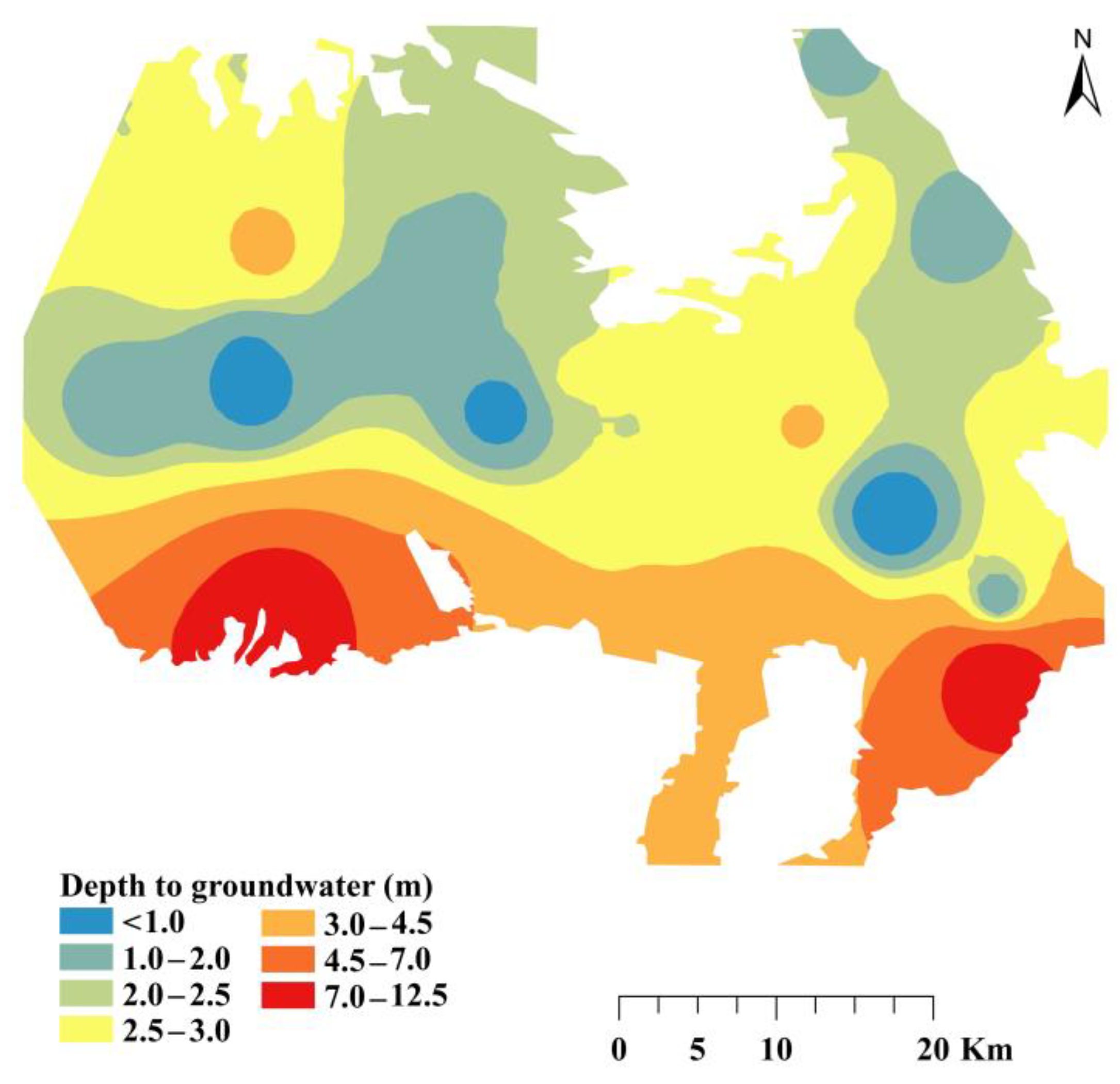
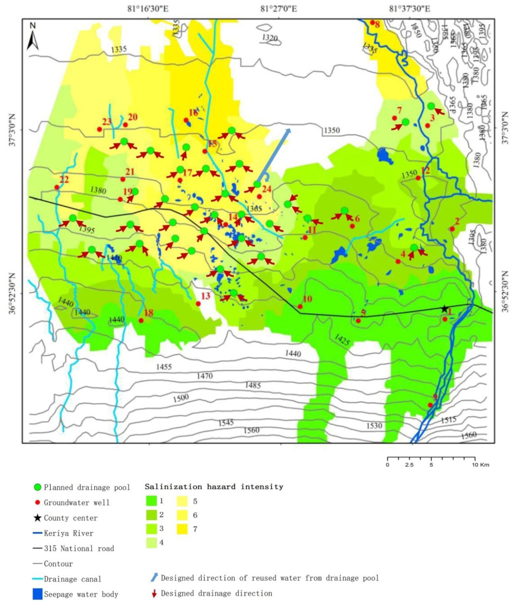
3.2. Spatial Hydro-Geological Features

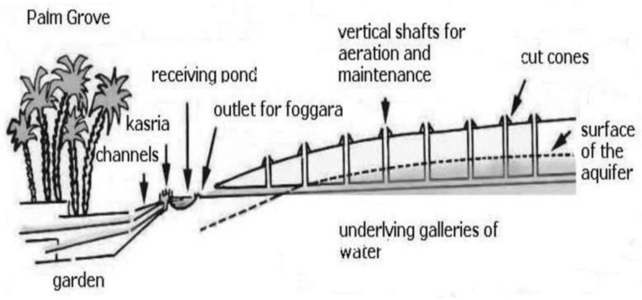
3.3. Traditional Ecological Knowledge
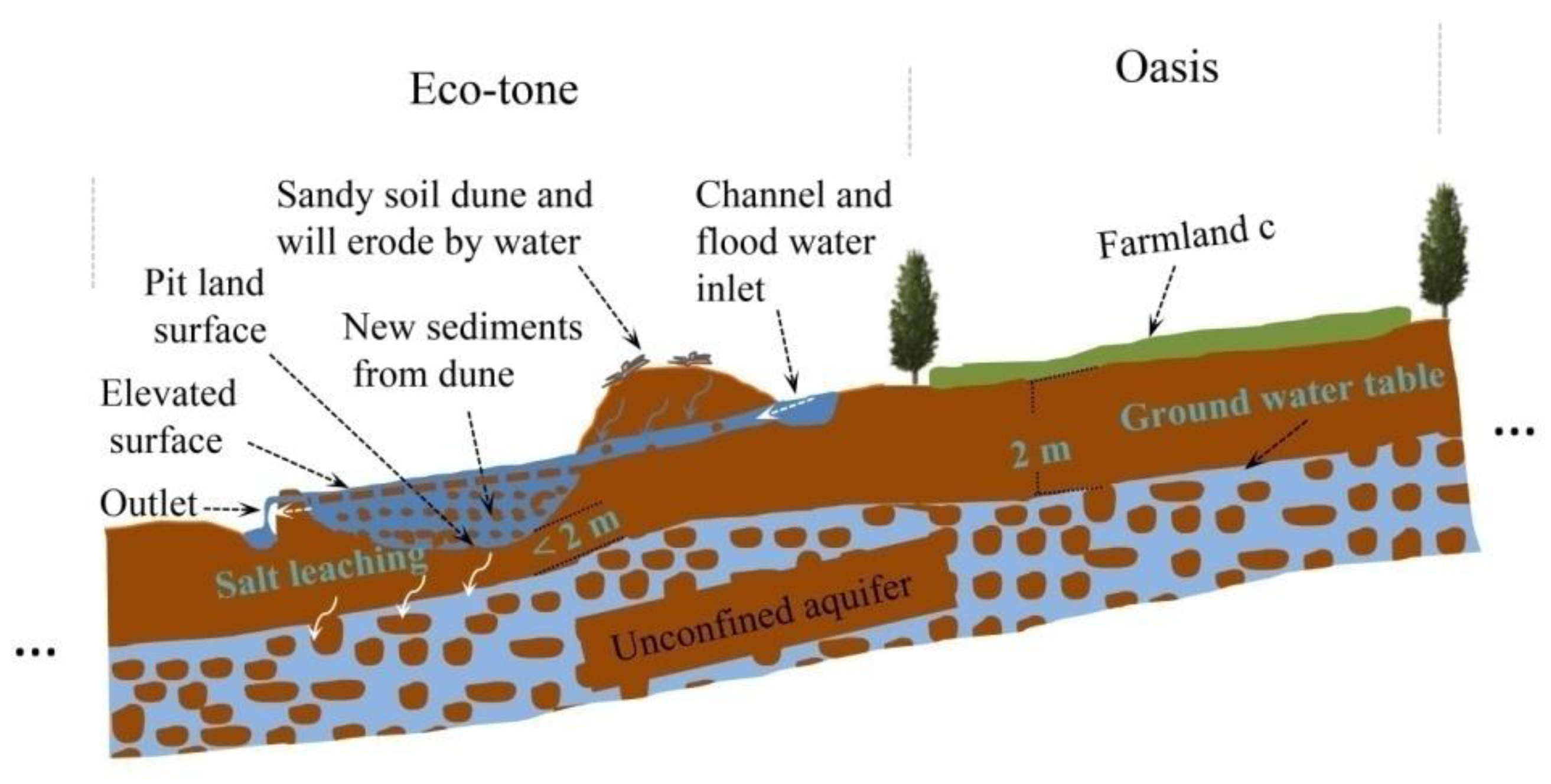
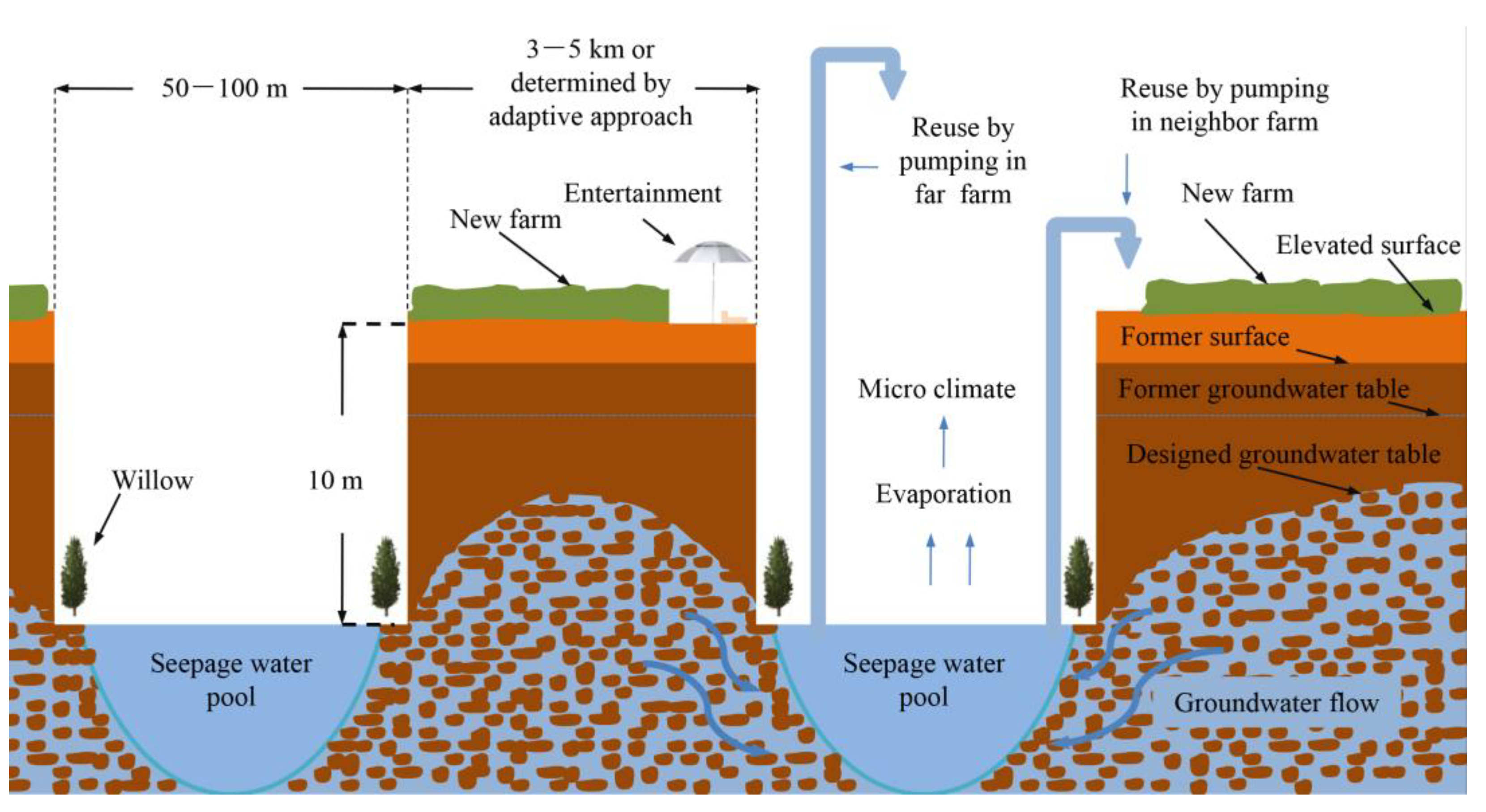
3.4. Desalinization Design for the Water Logging Area
3.5. Landscape Management for Desalinization
4. Discussion
5. Conclusions
Supplementary Materials
Author Contributions
Funding
Conflicts of Interest
References
- Wang, Y.; Li, Y. Land exploitation resulting in soil salinization in a desert-oasis ecotone. Catena 2013, 100, 50–56. [Google Scholar] [CrossRef]
- Eziz, M.; Yimit, H.; Nijad, D.; Wei, B. The Response of Ecosystem Services Value to Land Use Change in Keriya Oasis, Northern Slope of Kunlun Mountain. Sci. Geogr. Sin. 2012, 32, 1148–1154. (In Chinese) [Google Scholar] [CrossRef]
- Wiebe, B.H.; Eilers, R.G.; Eilers, W.D.; Brierley, J.A. Application of a risk indicator for assessing trends in dryland salinization risk on the Canadian Prairies. Can. J. Soil Sci. 2007, 87, 213–224. [Google Scholar] [CrossRef]
- Zhou, D.; Lin, Z.; Liu, L.; Zimmermann, D. Assessing secondary soil salinization risk based on the PSR sustainability framework. J. Environ. Manag. 2013, 128, 642–654. [Google Scholar] [CrossRef]
- Eziz, M.; Yimit, H.; Mohammad, A.; Zhifang, H. Oasis land-use change and its effects on the oasis eco-environment in Keriya Oasis, China. Int. J. Sustain. Dev. World Ecol. 2010, 17, 244–252. [Google Scholar] [CrossRef]
- Kosmas, C.; Kairis, O.; Karavitis, C.; Ritsema, C.; Salvati, L.; Acikalin, S.; Alcalá, M.; Alfama, P.; Atlhopheng, J.; Barrera, J.; et al. Evaluation and Selection of Indicators for Land Degradation and Desertification Monitoring: Methodological Approach. Environ. Manag. 2013, 54, 951–970. [Google Scholar] [CrossRef] [PubMed]
- Abliz, A.; Tiyip, T.; Ghulam, A.; Mamat, J.D.; Fei, S.; Ilyas, Z.; Abdugheni, N. Effects of shallow groundwater table and salinity on soil salt dynamics in the Keriya Oasis, Northwestern China. Environ. Earth Sci. 2016. [Google Scholar] [CrossRef]
- Seydehmet, J.; Lv, G.H.; Nurmemet, I.; Aishan, T.; Abliz, A.; Sawut, M.; Abliz, A.; Eziz, M. Model Prediction of Secondary Soil Salinization in the Keriya Oasis, Northwest China. Sustainability 2018, 10, 656. [Google Scholar] [CrossRef]
- Seydehmet, J.; Lv, G.H.; Abliz, A.; Shi, Q.D.; Turup, A. Irrigation Salinity Risk Assessment and Mapping in Arid Oasis, Northwest China. Water 2018, 10, 966. [Google Scholar] [CrossRef]
- Mitsch, W.J.; Lu, J.; Yuan, X.; He, W.; Zhang, L. Optimizing ecosystem services in China. Science 2008, 322, 528. [Google Scholar] [CrossRef] [PubMed]
- Fan, Z.L.; Ma, Y.-J.; Zhang, H.; Wang, R.H.; Zhao, Y.J. Research of eco–water table and rational depth of groundwater of Tarim River drainage basin. Arid Land Geogr. 2004, 27, 8–13. (In Chinese) [Google Scholar] [CrossRef]
- Wang, G.Y.; Teyibai, T.; Tan, L.Z. Social Driven Forces to Land Use Variation in Yutian Oasis–desert Ecotone in Xinjiang. J. Desert Res. 2006, 26, 259–263. (In Chinese) [Google Scholar] [CrossRef]
- Chen, C.; Meurk, C.; Chen, J.; Lv, M.; Wen, Z. Restoration design for Three Gorges Reservoir shorelands, combining Chinese traditional agro-ecological knowledge with landscape ecological analysis. Ecol. Eng. 2014, 71, 584–597. [Google Scholar] [CrossRef]
- Forman, R.T.T. Land Mosaics: The Ecology of Landscapes and Regions; Cambridge University Press: Cambridge, UK, 1995; p. 452. [Google Scholar]
- Moshia, M.E.; Mashatola, M.B.; Shaker, P.; Fouche, P.S.; Boshomane, M.A.W. Land suitability assessment and precision farming prospects for irrigated maize–soybean intercropping in Syferkuil experimental farm using geospatial information technology. J. Agric. Soc. Res. 2008, 8, 138–147. [Google Scholar] [CrossRef]
- Huntington, H.P. Using Traditional Ecological Knowledge in Science: Methods and Applications. Ecol. Appl. 2000, 10, 1270–1274. [Google Scholar] [CrossRef]
- Berkes, F.; Colding, J.; Folke, C. Rediscovery of Traditional Ecological Knowledge as Adaptive Management Published by: Ecological Society of America rediscovery of traditional ecological knowledge. Ecol. Appl. 2010, 10, 1251–1262. [Google Scholar] [CrossRef]
- Willison, J.H.M.; Li, R.; Yuan, X.Z. Conservation and eco-friendly utilization of wetlands associated with the Three Gorges Reservoir. Environ. Sci. Pollut. Res. 2013, 20, 6907–6916. [Google Scholar] [CrossRef]
- Yuan, X.Z.; Zhang, Y.W.; Liu, H.; Xiong, S.; Li, B.; Deng, W. The littoral zone in the Three Gorges Reservoir, China: Challenges and opportunities. Environ. Sci. Pollut. Res. 2013, 20, 7092–7102. [Google Scholar] [CrossRef]
- Li, B.; Xiao, H.; Yuan, X.; Willison, J.; Liu, H.; Chen, Z. Analysis of ecological and commercial benefits of a dike-pond project in the drawdown zone of theThree Gorges Reservoir. Ecol. Eng. 2013, 61, 1–11. [Google Scholar] [CrossRef]
- Li, B.; Yuan, X.; Xiao, H.; Chen, Z. Design of the dike-pond system in the lit-toral zone of a tributary in the Three Gorges Reservoir, China. Ecol. Eng. 2011, 37, 1718–1725. [Google Scholar] [CrossRef]
- Nurmemet, I.; Sagan, V. A WFS-SVM Model for Soil Salinity Mapping in Keriya Oasis, Northwestern China Using Polarimetric Decomposition and Fully PolSAR Data. Remote Seans. 2018. [Google Scholar] [CrossRef]
- Gong, L.; Ran, Q.; He, G.; Tiyip, T. A soil quality assessment under different land use types in Keriya river basin, Southern Xinjiang, China. Soil Tillage Res. 2015, 146, 223–229. [Google Scholar] [CrossRef]
- Mamat, Z.; Halik, U.; Muhtar, P.; Nurmamat, I. Influence of soil moisture and electrical conductivity on the growth of Phragmites australis (Cav.) in the Keriya oasis, China. Environ. Earth Sci. 2016, 75, 1–8. [Google Scholar] [CrossRef]
- Hao, L.; Su, X.; Singh, V.P.; Zhang, L.; Zhang, G. Suitable oasis and cultivated land scales in arid regions based on ecological health. Ecol. Indic. 2019, 102, 33–42. [Google Scholar] [CrossRef]
- Nurmemet, I.; Ghulam, A.; Tiyip, T.; Elkadiri, R.; Ding, J.L.; Maimaitiyiming, M.; Abliz, A.; Sawut, M.; Zhang, F.; Abliz, A.; et al. Monitoring soil salinization in Keriya River Basin, Northwestern China using passive reflective and active microwave remote sensing data. Remote Sens. 2015, 7, 8803–8829. [Google Scholar] [CrossRef]
- Benyamini, Y.; Mirlas, V.; Marish, S.; Gottesman, M.; Fizik, E.; Agassi, M. A survey of soil salinity and groundwater level control systems in irrigated fields in the Jezre’el Valley, Israel. Agric. Water Manag. 2005, 76, 181–194. [Google Scholar] [CrossRef]
- Corwin, D.L.; Rhoades, J.D.; Šimůnek, J. Leaching requirement for soil salinity control: Steady-state versus transient models. Agric. Water Manag. 2007, 90, 165–180. [Google Scholar] [CrossRef]
- Hamidian, A.; Ghorbani, M.; Abdolshahnejad, M.; Abdolshahnejad, A. RETRACTED: Qanat, Traditional Eco-technology for Irrigation and Water Management. Agric. Agric. Sci. Procedia 2015, 4, 119–125. [Google Scholar] [CrossRef]
- Ma, C.L.; Halik, W.; Liu, J.Q. The groundwater depth spatial temporal differentiation laws of different runoff changes in Keriya River Basin. J. Anhui Agric. Sci. 2013, 26. (In Chinese) [Google Scholar] [CrossRef]
- Akramkhanov, A.; Martius, C.; Park, S.J.; Hendrickx, J.M.H. Environmental factors of spatial distribution of soil salinity on flat irrigated terrain. Geoderma 2011, 163, 55–62. [Google Scholar] [CrossRef]
- Huang, J.; Prochazka, M.J.; Triantafilis, J. Irrigation salinity hazard assessment and risk mapping in the lower Macintyre Valley, Australia. Sci. Total Environ. 2016, 551–552, 460–473. [Google Scholar] [CrossRef] [PubMed]
- Spangenberg, J.H.; Douguet, J.M.; Settele, J.; Heong, K.L. Escaping the lock-in of continuous insecticide spraying in rice: Developing an integrated ecological and socio-political DPSIR analysis. Ecol. Model. 2015, 295, 188–195. [Google Scholar] [CrossRef]
- Hamzeh, S.; Naseri, A.A.; AlaviPanah, S.K.; Mojaradi, B.; Bartholomeus, H.M.; Clevers, J.G.P.W.; Behzad, M. Estimating salinity stress in sugarcane fields with spaceborne hyperspectral: Vegetation indices. Int. J. Appl. Earth Obs. Geoinf. 2012, 21, 282–290. [Google Scholar] [CrossRef]
- Yao, R.; Yang, J. Quantitative evaluation of soil salinity and its spatial distribution using electromagnetic induction method. Agric. Water Manag. 2010, 97, 1961–1970. [Google Scholar] [CrossRef]
- Zhou, D.; Lin, Z.; Liu, L.; State, N.D.; Dakota, N. Developing a Composite Risk Index for Secondary Soil Salinization Based on the PSR Sustainability Framework. In Proceedings of the 6th International Congress on Environmental Modelling and Software, Leipzig, Germany, 1–5 July 2012. [Google Scholar]
- U.S. Geological Survey. Available online: http://glovis.usgs.gov/ (accessed on 21 July 2015).
- Wei, Y.L.; Wang, H.; Li, N. Keriya County Annals, 1st ed.; Xinjiang People’s Press: Urumqi, Xinjiang, China, 2006; pp. 142–148, 162–164, 173–181, 300–313. (In Chinese) [Google Scholar]
- Tursun, T.; Jialalidin, A.; Mamat, R. A study on the ancient Turpan Karez engineering technologyand measuring method. Geotech. Investig. Surv. 2014, 42, 63–67. [Google Scholar] [CrossRef]
- Amine, M.; Bendida, A.; Khelfaoui, R. The impact of traditional irrigation (Foggara) and modern (drip, pivot) on the resource non-renewable groundwater in the Algerian Sahara. Energy Procedia 2013, 36, 154–162. [Google Scholar] [CrossRef][Green Version]
- Li, P.; Wu, J.; Qian, H. Regulation of secondary soil salinization in semi-arid regions: A simulation research in the Nanshantaizi area along the Silk Road, northwest China. Environ. Earth Sci. 2016, 75, 1–12. [Google Scholar] [CrossRef]
- Xiao, D.N.; Li, X. Zh.; Gao, J. Landscape Ecology, 5th ed.; Science Press: Peijing, China, 2007; pp. 114–203. (In Chinese) [Google Scholar]
- Nassauer, J.I.; Opdam, P. Design in science: Extending the landscape ecology paradigm. Landsc. Ecol. 2008, 23, 633–644. [Google Scholar] [CrossRef]
- Wang, S.J.; Chen, B.H.; Li, H.Q. Populus euphratica Oliv, 1st ed.; China Environmental Science Press: Beijing, China, 1995. (In Chinese) [Google Scholar]
- Wang, H.W.; Fan, Y.H.; Tiyip, T. The research of soil salinization human impact based on remote sensing classification in oasis irrigation area. Procedia Environ. Sci. 2011, 10, 2399–2405. [Google Scholar] [CrossRef]
- Zhang, W.T.; Wu, H.Q.; Gu, H.B.; Feng, G.L.; Wang, Z.; Sheng, J.D. Variability of Soil Salinity at Multiple Spatio-Temporal Scales and the Related Driving Factors in the Oasis Areas of Xinjiang, China. Pedosphere 2014, 24, 753–762. [Google Scholar] [CrossRef]
- Yu, P.; Xu, H.; Liu, S.; Qiao, M.; Zhang, Q.; An, H.; Fu, J. Spatial distribution pattern changes of oasis soil types in Manasi River Basin, arid northwestern China. Catena 2011, 87, 253–259. [Google Scholar] [CrossRef]
- Xie, Y.; Gong, J.; Sun, P.; Gou, X. Oasis dynamics change and its influence on landscape pattern on Jinta oasis in arid China from 1963a to 2010a: Integration of multi-source satellite images. Int. J. Appl. Earth Obs. Geoinf. 2014, 33, 181–191. [Google Scholar] [CrossRef]
- Muhtar, P.; Yimit, H. Ecosystem Services Sensitivity to Land–use Change:A Case Study of the Keriya Oasis. J. Nat. Resour. 2014, 29, 1849–1858. [Google Scholar]
- Zhang, B.; Xiong, H.; Xu, C.C. Study on Ecological Resilience and Environment in Yutian Oasis, Xinjiang. Res. Soil Water Conserv. 2008, 15, 112–114. [Google Scholar]
- Ling, H.; Xu, H.; Fu, J.; Fan, Z.; Xu, X. Suitable oasis scale in a typical continental river basin in an arid region of China: A case study of the Manas River Basin. Quat. Int. 2013, 286, 116–125. [Google Scholar] [CrossRef]
- Amuti, T.; Luo, G. Analysis of land cover change and its driving forces in a desert oasis landscape of Xinjiang, northwest China. Solid Earth 2014, 5, 1071–1085. [Google Scholar] [CrossRef]
- Zhang, X.; Zhang, L.; He, C.; Li, J.; Jiang, Y.; Ma, L. Quantifying the impacts of land use/land cover change on groundwater depletion in Northwestern China—A case study of the Dunhuang oasis. Agric. Water Manag. 2014, 146, 270–279. [Google Scholar] [CrossRef]


| Type and Symbols in Figure 7 | Location and Geo-Hydrological Characteristics | Management Strategy | Illustration |
|---|---|---|---|
Farmland (a, b) | Groundwater table is suitable, infiltration is dominant, uses flood irrigation, water use efficiency is low. | To decrease infiltration and increase the irrigation efficiency, it is necessary to use drip irrigation technology. |  |
Gobi | Depth of ground water is greater than 4m, slope is high, has good potential drainage conditions. | Could be used for future reclamation, but would cause the groundwater table to rise in farmland (a,b,c). Hence, drainage should bea priority. |  |
Farmland c | Depth of ground water is less than 2m, flat terrace, marginal farmland under salinity hazard. | Decrease the groundwater table and salt leaching by modern or traditional drainage with flood irrigation. |  |
Farmland c | Depth of steady shallow groundwater is less than 2m, flat terrace, clay soil, increasingly dry rice field. | Decrease the groundwater table, and increase slopes and salt leaching using the conceptual model of desalinization presented in this study (Figure 9, Figure 10). |  |
Wet meadow | Depth of steady shallow groundwater is less than 2m, flat terrace, clay soil. |  | |
Meadow and farmland c | Depth of steady shallow groundwater is 2m. Under salinity stress. |  | |
Populuseuphratica and meadow | Depth of steady shallow groundwater is more than 4m, located northwest in the marginal area of the oasis and desert. | Preserved |  |
| Inner marsh | Depth of shallow groundwater is less than 1m, located in the inner area of the oasis. | Decrease the groundwater table, and increase the slopes and salt leaching using the conceptual model of desalinization presented in this study (Figure 9, Figure 10). |  |
Inner meadow | Depth of shallow ground water is less than 2m, located in the inner area of the oasis. |  | |
| Inner marsh | Depth of shallow ground water is less than 1m, located in the inner area of oasis. |  | |
| Inner marsh | Depth of shallow groundwater is less than 1m, located in the inner area of the oasis. |  | |
Marginal meadow | Depth of shallow groundwater is less than 2m, located in the marginal area of the eco-tone and desert. | Preserved |  |
| Marginal meadow | Depth of shallow groundwater is greater than 4m, located in the marginal area of the eco-tone and desert. | Preserved |  |
| Populuseuphratica and meadow | Depth of shallow groundwater is greater than 4m, located in the marginal area of the eco-tone and desert. | Preserved |  |
| Margin marsh | Depth of the shallow groundwater is greater than 4m, located in the marginal area of the eco-tone and desert. | Preserved |  |
© 2019 by the authors. Licensee MDPI, Basel, Switzerland. This article is an open access article distributed under the terms and conditions of the Creative Commons Attribution (CC BY) license (http://creativecommons.org/licenses/by/4.0/).
Share and Cite
Seydehmet, J.; Lv, G.-H.; Abliz, A. Landscape Design as a Tool to Reduce Soil Salinization: The Study Case of Keriya Oasis (NW China). Sustainability 2019, 11, 2578. https://doi.org/10.3390/su11092578
Seydehmet J, Lv G-H, Abliz A. Landscape Design as a Tool to Reduce Soil Salinization: The Study Case of Keriya Oasis (NW China). Sustainability. 2019; 11(9):2578. https://doi.org/10.3390/su11092578
Chicago/Turabian StyleSeydehmet, Jumeniyaz, Guang-Hui Lv, and Abdugheni Abliz. 2019. "Landscape Design as a Tool to Reduce Soil Salinization: The Study Case of Keriya Oasis (NW China)" Sustainability 11, no. 9: 2578. https://doi.org/10.3390/su11092578
APA StyleSeydehmet, J., Lv, G.-H., & Abliz, A. (2019). Landscape Design as a Tool to Reduce Soil Salinization: The Study Case of Keriya Oasis (NW China). Sustainability, 11(9), 2578. https://doi.org/10.3390/su11092578