Changing Coal Mining Brownfields into Green Infrastructure Based on Ecological Potential Assessment in Xuzhou, Eastern China


Abstract
1. Introduction
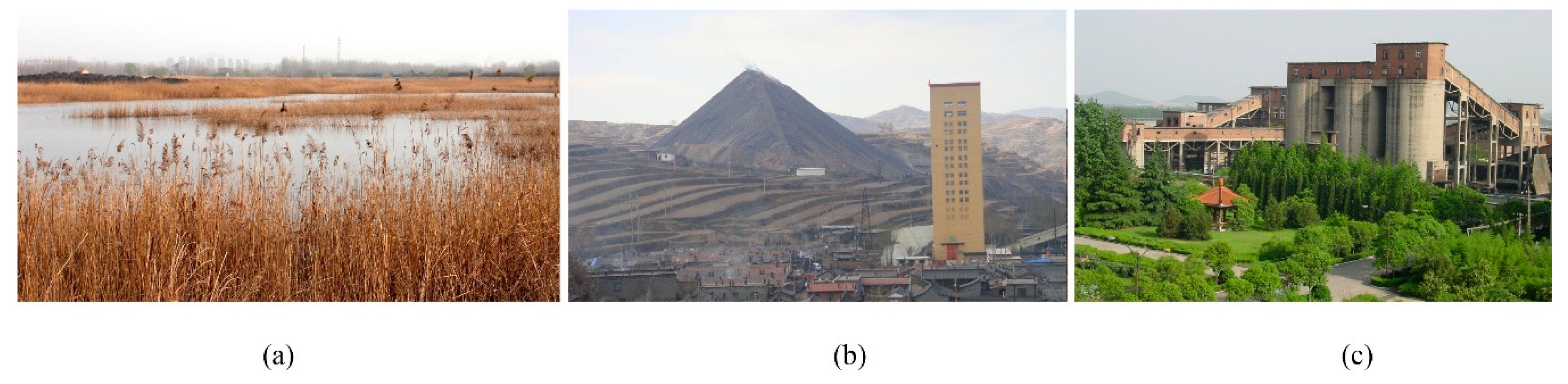
2. Coal Mining Brownfield in Xuzhou, Eastern China
3. Methodology
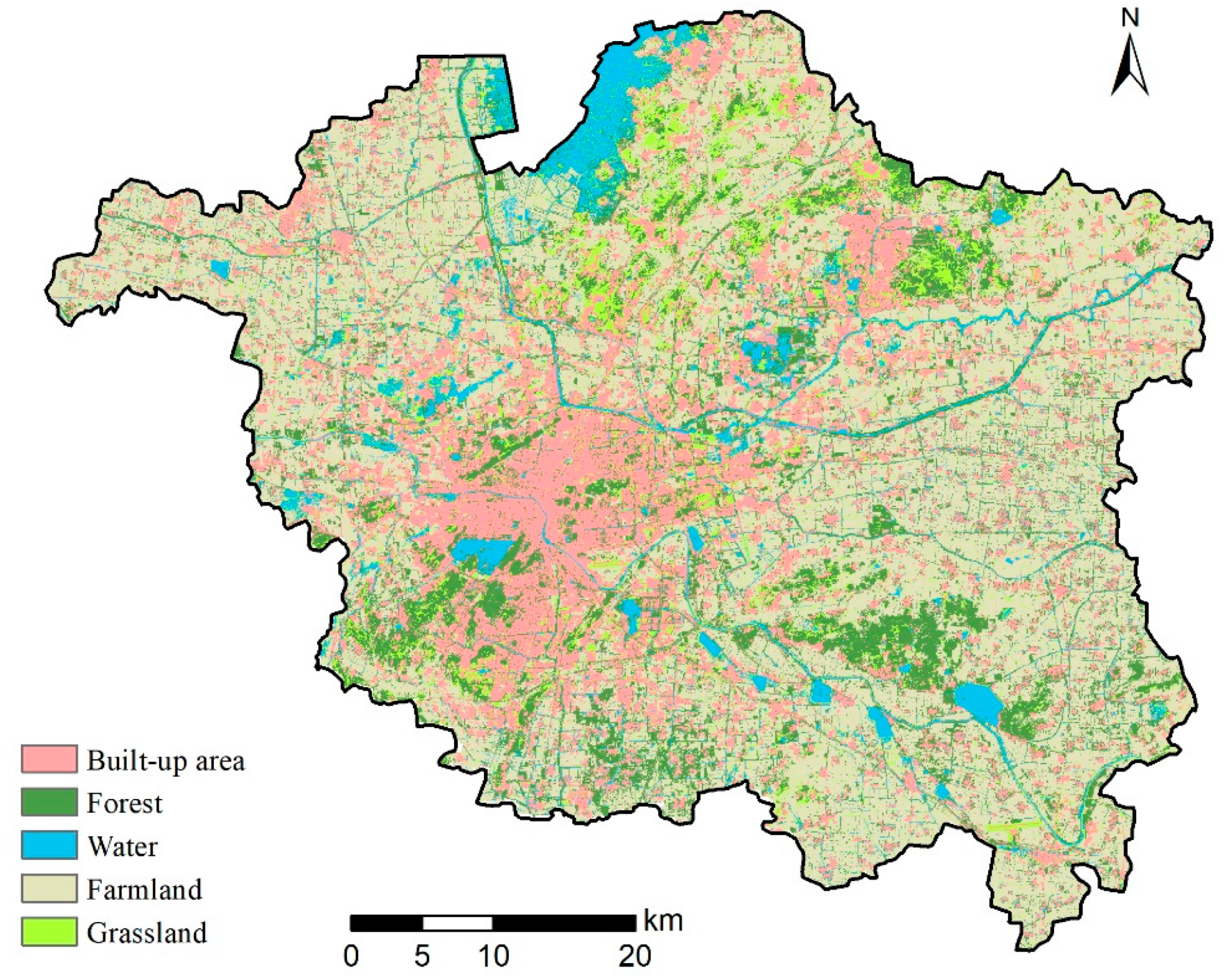
3.1. Data Sources
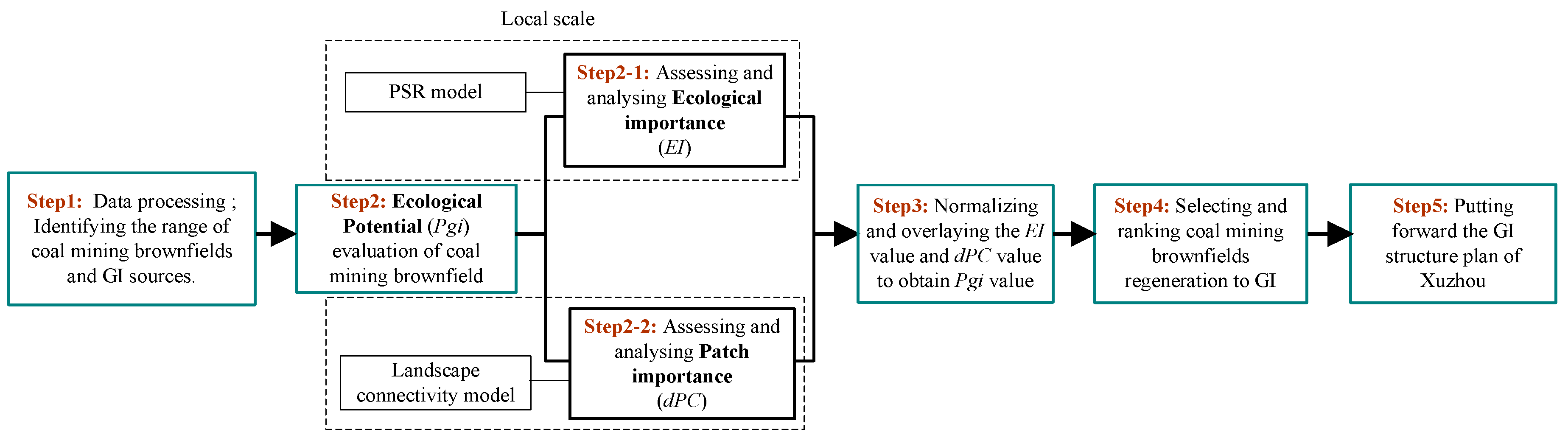
3.2. Analytical Method
4. Results
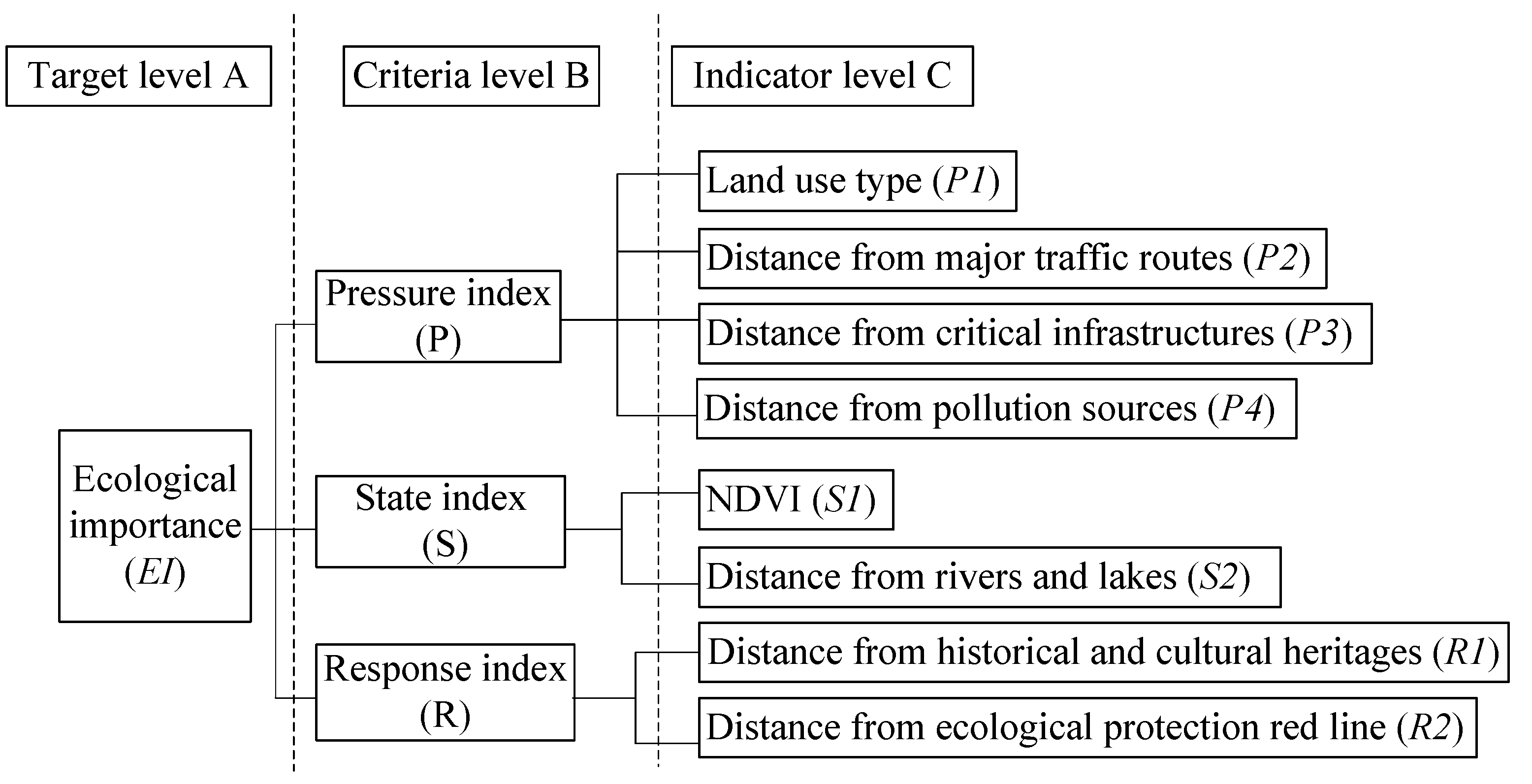
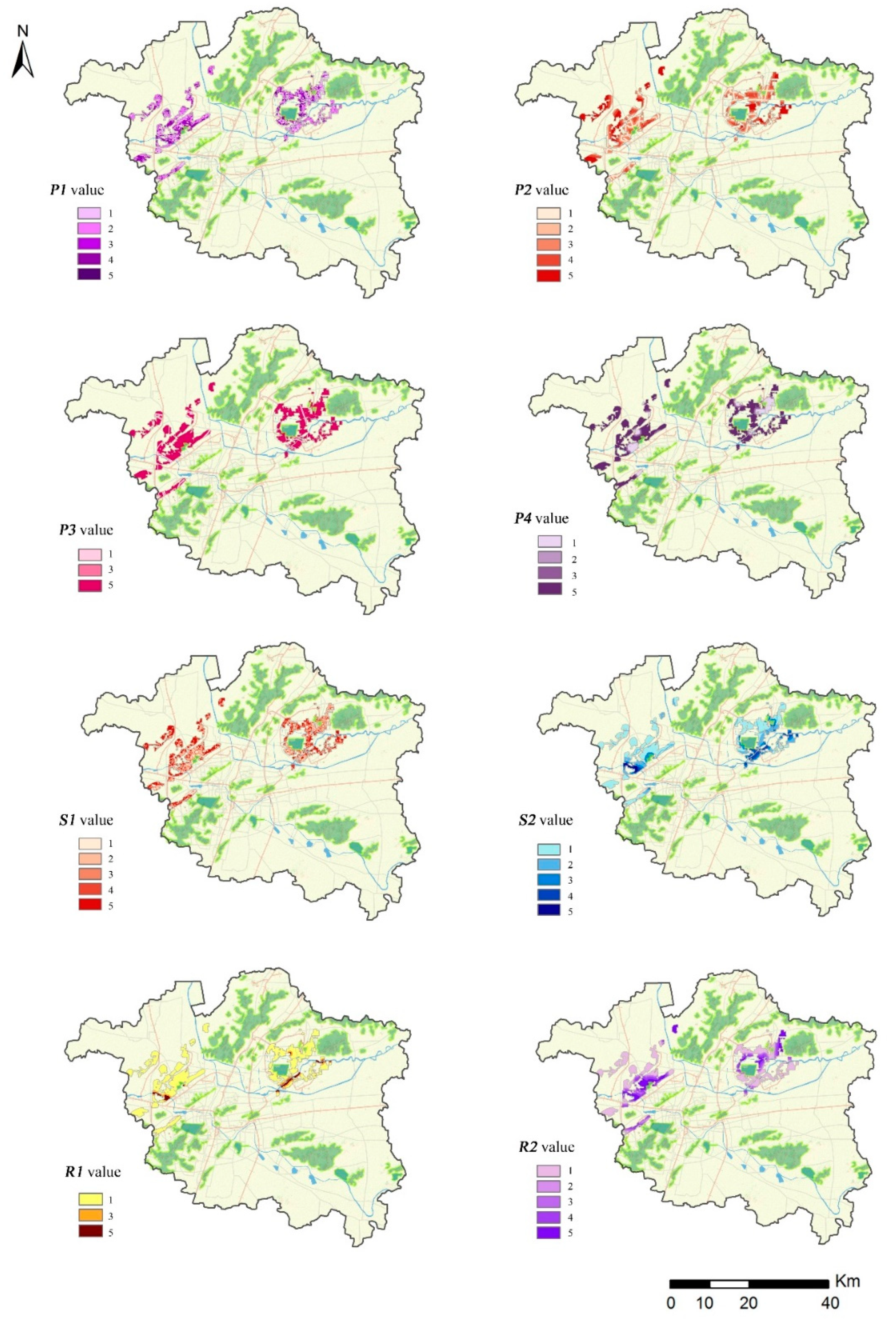
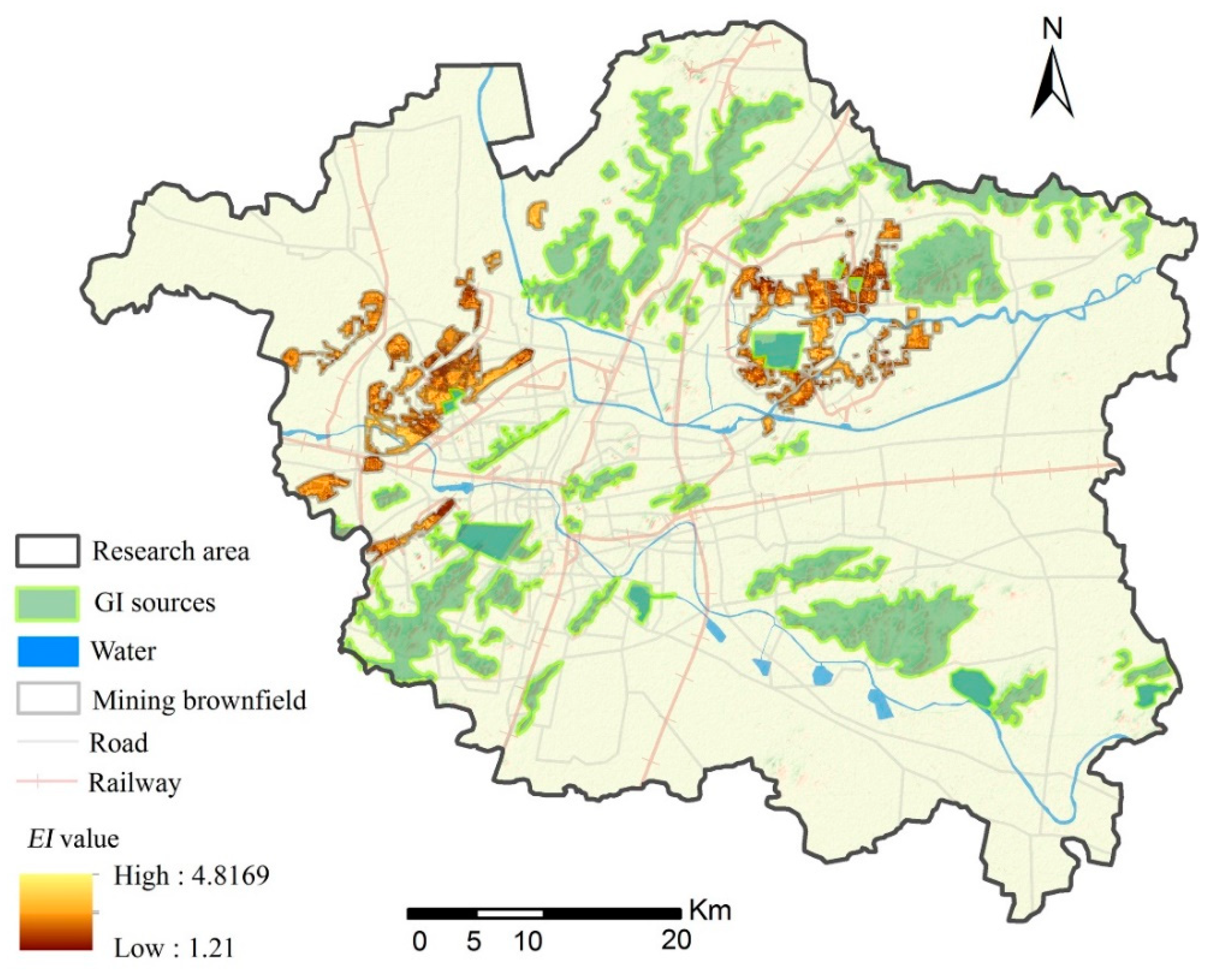
4.1. Ecological Importance Value (EI)
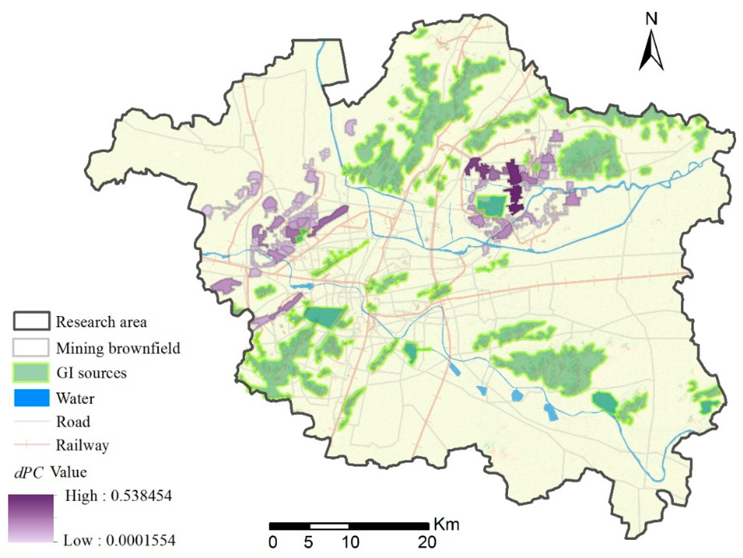
4.2. Patch Importance Value (dPC)
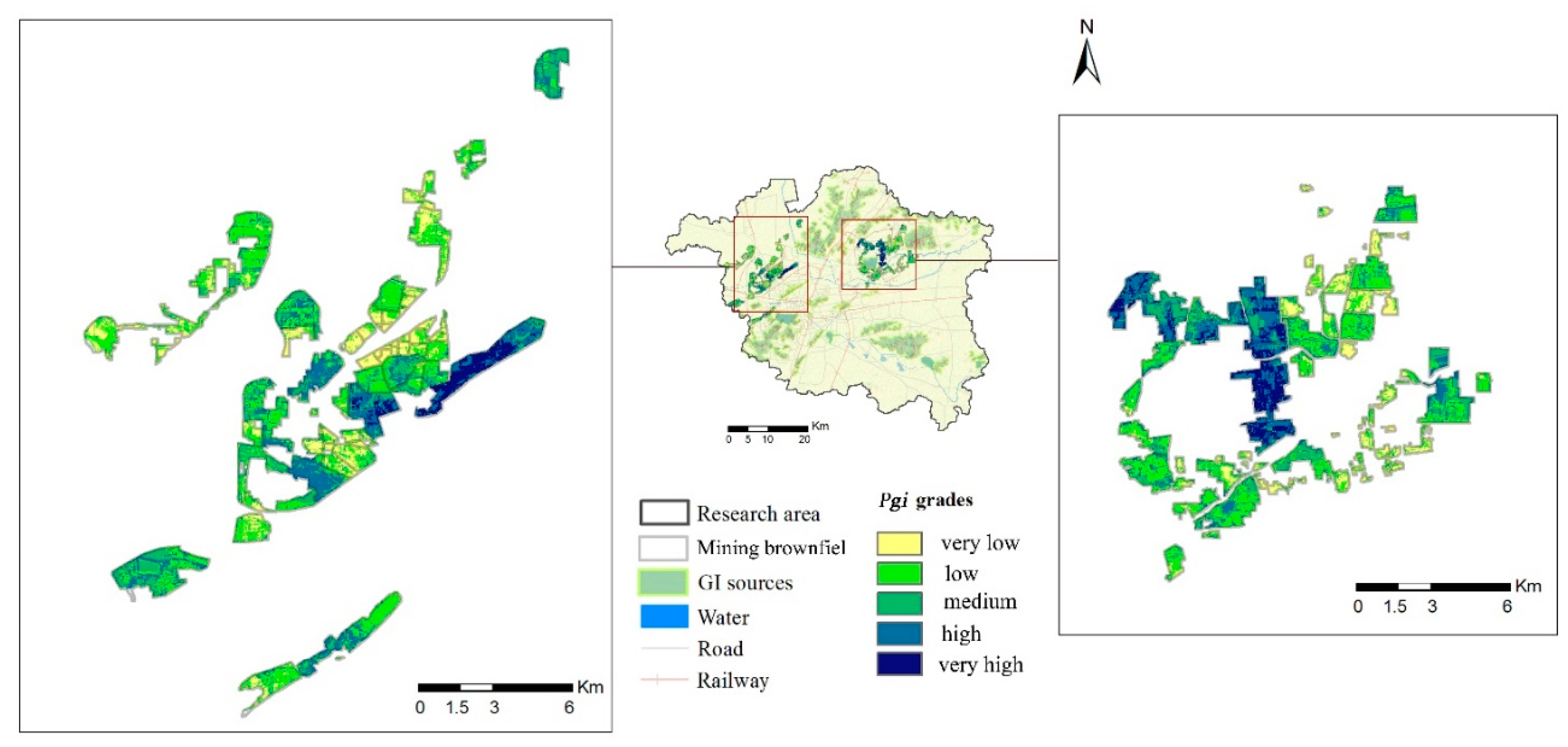
4.3. The Ecological Potential Value (Pgi)
5. Discussion and Conclusion
Author Contributions
Funding
Conflicts of Interest
References
- Hu, Z.Q.; Fu, Y.H.; Xiao, W.; Zhao, Y.L.; Wei, T.T. Ecological restoration plan for abandoned underground coal mine site in Eastern China. Int. J. Min. Reclam. Environ. 2015, 29, 316–330. [Google Scholar] [CrossRef]
- Feng, Y.X.; Li, G.W. Planning and design theory of mining brownfield based on landscape urbanism. Urban Plan. J. 2013, 208, 93–98. [Google Scholar] [CrossRef]
- Zhou, M.; Chen, H. Preliminary study on spatial models, problems and planning strategies of resource-based cities. Mod. Urban. Res. 2011, 7, 55–58. [Google Scholar] [CrossRef]
- Yang, Z.B.; Bian, Z.F. Study on the degradation mechanism of ecosystem in mining areas of Eastern China. Energy Environ. Prot. 2000, 14, 44–47. [Google Scholar] [CrossRef]
- Yang, G.H.; Hu, Z.Q.; Zhao, Y.L.; Yang, Y.Q.; Yu, Y. Study on reclamation and control of coal mining subsidence land with high groundwater level. Coal Eng. 2014, 46, 91–95. [Google Scholar] [CrossRef]
- Ye, D.J.; Zhan, X.M. Study on renovation and ecological restoration of coal mining subsidence area: A case study of conceptual planning of Pan’an Lake Wetland Park, Xuzhou. China Water Transp. 2011, 11, 242–243. [Google Scholar] [CrossRef]
- Qu, J.F.; Li, G.; Zhang, S.L. Reclamation and wetland ecological protection in high-phreatic-water level mining subsidence area: A case study of Jiuli, Xuzhou. Soil Water Conserv. China 2014, 1, 37–39. [Google Scholar] [CrossRef]
- Zhao, Y.H.; Zhao, H. Analysis of spatial expansion characteristics of water area in high-phreatic-water level mining area: A case study of Peibei mining area in Xuzhou. China Min. Ind. 2017, 26, 95–98. [Google Scholar] [CrossRef]
- Fu, Y.H.; Hu, Z.Q.; Xiao, W.; Rong, Y.; Long, J.H. Ecological restoration of coal subsidence wetland in high diving mining area. Wetl. Sci. 2016, 14, 671–676. [Google Scholar] [CrossRef]
- Xiao, W.; Chen, J.L.; Hu, Z.Q.; Chen, Y.C.; Zhang, J.Y. Feasibility analysis and practice of constructing plain reservoir in coal mining subsidence area with high groundwater level. Coal Sci. Technol. 2017, 45, 184–189. [Google Scholar] [CrossRef]
- Loures, L.; Panagopoulos, T. Reclamation of derelict industrial land in Portugal: Greening is not enough. Int. J. Sustain. Dev. Plan. 2010, 5, 343–350. [Google Scholar] [CrossRef]
- Sousa, D.; Christopher, A. The greening of brownfields in American cities. J. Environ. Plan. Manag. 2004, 47, 579–600. [Google Scholar] [CrossRef]
- Dorsey, J.W. Brownfields and Greenfields: The Intersection of Sustainable Development and Environmental Stewardship. Environ. Pract. 2003, 5, 69–76. [Google Scholar] [CrossRef]
- Sousa, D.; Christopher, A. Unearthing the benefits of brownfield to green space projects: An examination of project use and quality of life impacts. Local Environ. 2006, 11, 577–600. [Google Scholar] [CrossRef]
- Doick, K.J.; Sellers, G.; Castán Broto, V.; Silverthorne, T. Understanding success in the context of brownfield greening projects: The requirement for outcome evaluation in urban greenspace success assessment. Urban For. Urban Green. 2009, 8, 163–178. [Google Scholar] [CrossRef]
- Atkinson, G.; Doick, K.J.; Burningham, K.; France, C. Brownfield regeneration to greenspace: Delivery of project objectives for social and environmental gain. Urban For. Urban Green. 2014, 13, 586–594. [Google Scholar] [CrossRef]
- Pediaditi, K.; Doick, K.J.; Moffat, A.J. Monitoring and evaluation practice for brownfield, regeneration to greenspace initiatives: A meta-evaluation of assessment and monitoring tools. Landsc. Urban Plan. 2010, 97, 22–36. [Google Scholar] [CrossRef]
- Sousa, C.A.D. Turning brownfields into green space in the city of Toronto. Landsc. Urban Plan. 2003, 62, 181–198. [Google Scholar] [CrossRef]
- Siikamäki, J.; Wernstedt, K. Turning brownfields into greenspaces: Examining incentives and barriers to revitalization. J. Health Polit. Policy Law 2008, 33, 559–593. [Google Scholar] [CrossRef] [PubMed]
- Altherr, W.; Blumer, D.; Oldvorp, H.; Nagel, P. How do stakeholders and legislation influence the allocation of green space on brownfield redevelopment projects? Five case studies from Switzerland, Germany and the UK. Bus. Strategy Environ. 2010, 16, 512–522. [Google Scholar] [CrossRef]
- Mathey, J.; Rößler, S.; Banse, J.; Lehmann, I.; Bräuer, A. Brownfields as an element of green infrastructure for implementing ecosystem services into urban areas. J. Urban Plan. Dev. 2015, 141, A4015001. [Google Scholar] [CrossRef]
- Gill, S.E.; Handley, J.F.; Ennos, A.R.; Pauleit, S. Adapting cities for climate change: The role of the green infrastructure. Built Environ. 2007, 33, 115–133. [Google Scholar] [CrossRef]
- Feng, S.S.; Chang, J. Mining brownfield: Opportunity to improve green infrastructure. Chin. Landsc. Archit. 2017, 33, 24–28. [Google Scholar]
- Wirth, P.; Chang, J.; Syrbe, R.U.; Wende, W.; Hu, T. Green infrastructure: A planning concept for the urban transformation of former coal-mining cities. Int. J. Coal Sci. Technol. 2018, 5, 1–14. [Google Scholar] [CrossRef]
- Lin, Z.R.; Chang, J.; Wang, W. Ecological restoration planning of coal mining subsidence area in Xuzhou based on urban-rural coordination. Mod. Urban Res. 2009, 10, 91–95. [Google Scholar] [CrossRef]
- Sino-German Research Center of CUMT. Ecological Restoration Planning of Coal Mining Subsidence Area in Xuzhou; Research Report; CUMT: Xuzhou, China, 2012. [Google Scholar]
- Luo, P.J.; Lu, W.X.; Ren, L.Y. Re-use planning methods of the mining subsidence area based on landscape ecology: A case study of Jiuli area, Xuzhou. Chin. Landsc. Archit. 2011, 27, 96–100. [Google Scholar] [CrossRef]
- Yang, R.Q.; Wang, Q.Q.; Xu, D.L. Investigation of the plant diversity in Pan’an Lake Wetland Park. J. Northwest For. Univ. 2018, 33, 285–289. [Google Scholar] [CrossRef]
- Ma, Y.H.; Zhang, Y.J. Wetland ecotourism development strategy for coal mining subsidence wetland—A case study of Jiuli Lake in Xuzhou city. Wetl. Sci. Manag. 2013, 2, 21–24. [Google Scholar] [CrossRef]
- Chang, J.; Hu, T.H.; Liu, X.X.; Ren, X.G. Construction of green infrastructure in coal-resource based city: A case study in Xuzhou urban area. Int. J. Coal Sci. Technol. 2018, 5, 92–104. [Google Scholar] [CrossRef]
- Qiu, Y.; Chang, Q.; Wang, J.A. MSPA-based planning of urban Green Infrastructure network-a case of Shenzhen. Chin. Landsc. Archit. 2013, 5, 104–108. [Google Scholar]
- Xie, H.L.; Li, X.B. Spatial assessment and zoning regulations of ecological importance based on GIS for rural habitation in Changgang Town, Xinguo county. Acta Ecol. Sin. 2011, 31, 230–238. [Google Scholar] [CrossRef]
- Zhou, B.Z.; Yang, H.; Bao, H.S.; Zhao, Q.G.; Zhou, S.L. PSR model and its application in the evaluation of sustainable land-use in the region. J. Nat. Resour. 2002, 17, 541–548. [Google Scholar] [CrossRef]
- Xie, G.D.; Zhen, L.; Lu, C.X.; Xiao, Y.; Chen, C. An expert knowledge-based approach to ecosystem service value. J. Nat. Resour. 2008, 23, 911–919. [Google Scholar] [CrossRef]
- Yang, F.; He, Y.; Zhao, Z.J. An evaluation method of nimby effect of urban municipal infrastructure. J. Peking Univ. (Nat. Sci. Ed.) 2017, 53, 518–524. [Google Scholar] [CrossRef]
- Shen, S.G.; Wang, H.; Jia, D.P.; Gu, K. Land suitability evaluation methods for urban green space system planning based on GIS in Changzhou city. J. Nanjing For. Univ. (Nat. Sci.) 2009, 33, 72–76. [Google Scholar] [CrossRef]
- Lu, T.W.; Song, K.; Yang, X.; Wang, X.J. Research of urban land-use planning based on ecology suitability evaluation: A case study of ecological subzone in Southeast Hangzhou. J. Fudan Univ. (Nat. Sci.) 2011, 50, 245–251. [Google Scholar] [CrossRef]
- He, D.; Jin, F.J.; Zhou, J. Urban construction land suitability evaluation in resource-based cities: Taking the Grand Canal Ecologic and Economic Area as an example. Geogr. Res. 2011, 30, 655–666. [Google Scholar] [CrossRef]
- Chen, Y.F.; Du, P.F.; Zhen, X.J.; Lin, J. Evaluation on ecological applicability of land construction in Nanning city based on GIS. J. Tsinghua Univ. (Sci. Technol.) 2006, 46, 801–804. [Google Scholar] [CrossRef]
- Wu, J.S.; Zhang, L.Q.; Peng, J.; Feng, Z.; Liu, H.M.; He, Z.B. The integrated recognition of the source area of the urban ecological security pattern in Shenzhen. Acta Ecol. Sin. 2013, 33, 4125–4133. [Google Scholar] [CrossRef]
- Xiong, C.N.; Wei, H.; Lan, M.J. Analysis of connectivity on greenland landscape in metropolitan region of Chongqing City. Acta Ecol. Sin. 2008, 28, 2237–2244. [Google Scholar] [CrossRef]


| Index | Indicator | Class Condition | Value | References | |
|---|---|---|---|---|---|
| Pressure Index | Land-use type (P1) | Forest | 5 | According to the weight of each habitat type that characterizes the habitat quality index in the “Technical Specifications for Ecological Environment Assessment” (HJ192-2015), forest has the highest value, and construction land has the lowest value [34]. | |
| Water | 4 | ||||
| Grassland | 3 | ||||
| Cultivated land | 2 | ||||
| Construction land | 1 | ||||
| Distance from major traffic routes (P2) | Buffer larger than 1000 m | 5 | [32] | ||
| 500–1000 m buffer | 4 | ||||
| 200–500 m buffer | 3 | ||||
| 100–200 m buffer | 2 | ||||
| 0–100 m buffer | 1 | ||||
| Distance from critical infrastructures (P3) | Buffer larger than 75 m | 5 | Referring to the “power project status map of Xuzhou” (2014), power plants and high-pressure lines above 500 kv were selected. According to the "Urban Electric Power Planning Code" (GB/T 50293-2014), buffer division of high-pressure corridors were defined [35]. | ||
| 40–75 m buffer | 3 | ||||
| 0–40m buffer | 1 | ||||
| Distance from pollution sources (P4) | Buffer larger than 800 m | 5 | According to the “environmental protection and sanitation status map of Xuzhou”(2014), pollution sources include industrial land (I class), coal gangue dump, landfill, sewage treatment plant [36]. | ||
| 500–800 m buffer | 3 | ||||
| 300–500 m buffer | 2 | ||||
| 0–300 m buffer | 1 | ||||
| StateIndex | NDVI (S1) | 0.6 < NDVI < 1 | 5 | [32] | |
| 0.4 < NDVI < 0.6 | 4 | ||||
| 0.2 < NDVI < 0.4 | 3 | ||||
| 0 < NDVI < 0.2 | 2 | ||||
| Distance from rivers and lakes (S2) | 1st order stream | 0–500 m buffer | 5 | [32,37] | |
| 500–1000 m buffer | 3 | ||||
| 1000–2000 m buffer | 2 | ||||
| Buffer larger than 2000 m | 1 | ||||
| 2nd order stream | 0–100 m buffer | 3 | |||
| Buffer larger than 100 m | 1 | ||||
| Lake | 0–500m buffer | 3 | |||
| Buffer larger than 500 m | 1 | ||||
| ResponseIndex | Distance from historical and cultural heritages (R1) | 0–200 m buffer | 5 | [38] | |
| 200–500 m buffer | 3 | ||||
| Buffer larger than 500 m | 1 | ||||
| Distance from ecological protection red line (R2) | In the red line | 5 | Referring to the “Ecological Red Line Regional Protection Plan of Jiangsu Province” (2013), the ecological red line area includes various nature reserves, scenic spots, forest parks, and important water conservation areas. Buffer division standard referenced literature [39]. | ||
| 0–500 m buffer | 4 | ||||
| 500–800 m buffer | 3 | ||||
| 800–1000 buffer | 2 | ||||
| Buffer larger than 1000 m | 1 | ||||
| Criteria | Criteria Weight | Indicator | Indicator Weight | Sequence |
|---|---|---|---|---|
| Pressure index (P) | 0.4934 | P1 | 0.2951 | 1 |
| P2 | 0.0525 | 7 | ||
| P3 | 0.0525 | 7 | ||
| P4 | 0.0933 | 5 | ||
| State index (S) | 0.3108 | S1 | 0.2072 | 2 |
| S2 | 0.1036 | 4 | ||
| Response index (R) | 0.1958 | R1 | 0.0653 | 6 |
| R2 | 0.1305 | 3 |
© 2019 by the authors. Licensee MDPI, Basel, Switzerland. This article is an open access article distributed under the terms and conditions of the Creative Commons Attribution (CC BY) license (http://creativecommons.org/licenses/by/4.0/).
Share and Cite
Feng, S.; Hou, W.; Chang, J. Changing Coal Mining Brownfields into Green Infrastructure Based on Ecological Potential Assessment in Xuzhou, Eastern China. Sustainability 2019, 11, 2252. https://doi.org/10.3390/su11082252
Feng S, Hou W, Chang J. Changing Coal Mining Brownfields into Green Infrastructure Based on Ecological Potential Assessment in Xuzhou, Eastern China. Sustainability. 2019; 11(8):2252. https://doi.org/10.3390/su11082252
Chicago/Turabian StyleFeng, Shanshan, Wei Hou, and Jiang Chang. 2019. "Changing Coal Mining Brownfields into Green Infrastructure Based on Ecological Potential Assessment in Xuzhou, Eastern China" Sustainability 11, no. 8: 2252. https://doi.org/10.3390/su11082252
APA StyleFeng, S., Hou, W., & Chang, J. (2019). Changing Coal Mining Brownfields into Green Infrastructure Based on Ecological Potential Assessment in Xuzhou, Eastern China. Sustainability, 11(8), 2252. https://doi.org/10.3390/su11082252