Mapping Methodology of Public Urban Green Spaces Using GIS: An Example of Nagpur City, India


Abstract
Highlights:
- The overall accuracy of the thematic map is 95% and the kappa statistic is 0.93.
- The thematic map presents a realistic picture of available recreational UGS prevalent in the city.
- The hierarchical distribution of different typologies highlights the lack of provision with regard to sub-city and district green spaces.
- The spatial distribution of green spaces is uneven.
1. Introduction
2. Materials and Methods
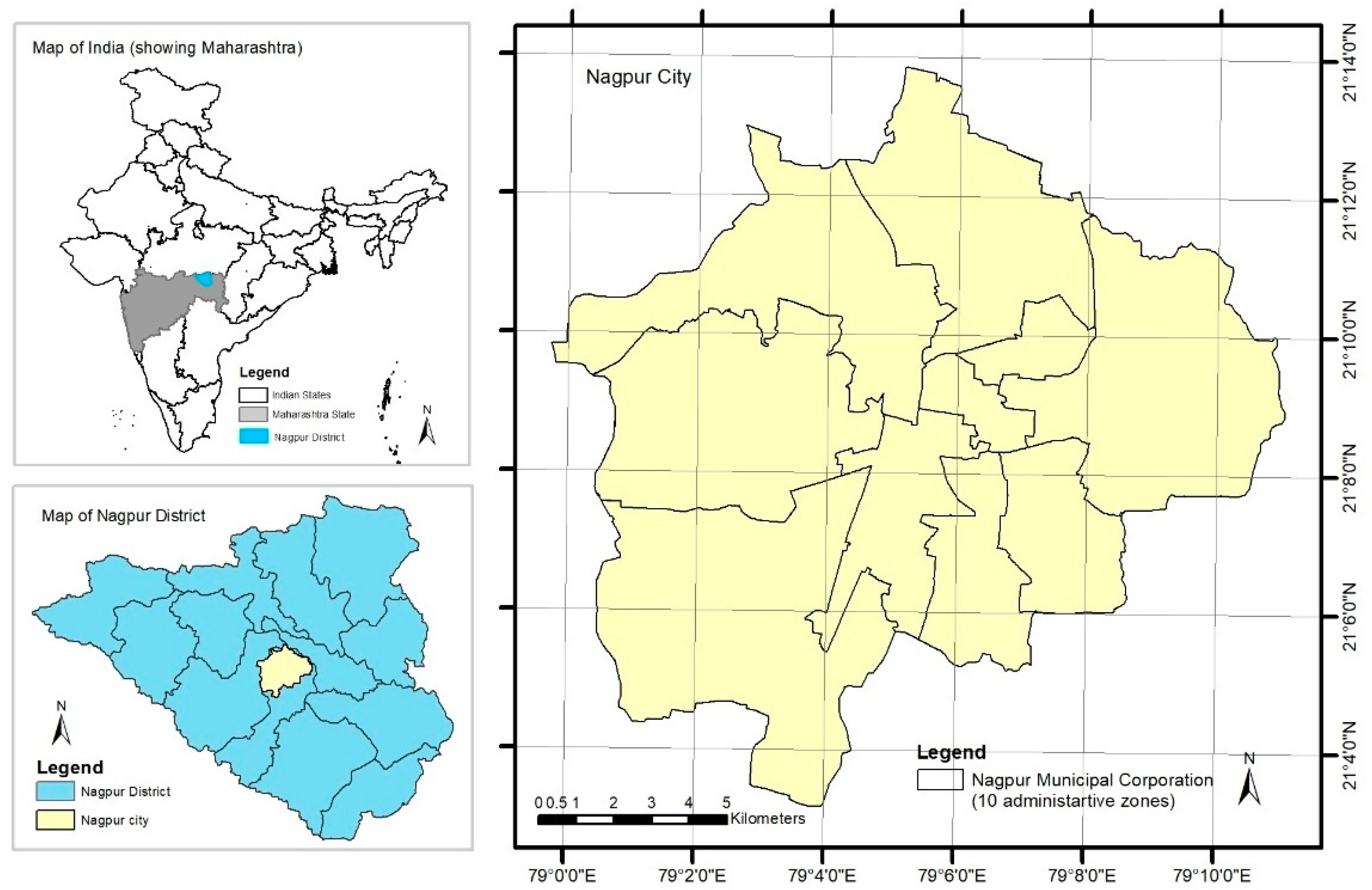
2.1. Study Area
2.2. Workflow of Thematic Map
2.3. Supporting Data
2.4. Identified UGS Typologies and Classes for Mapping
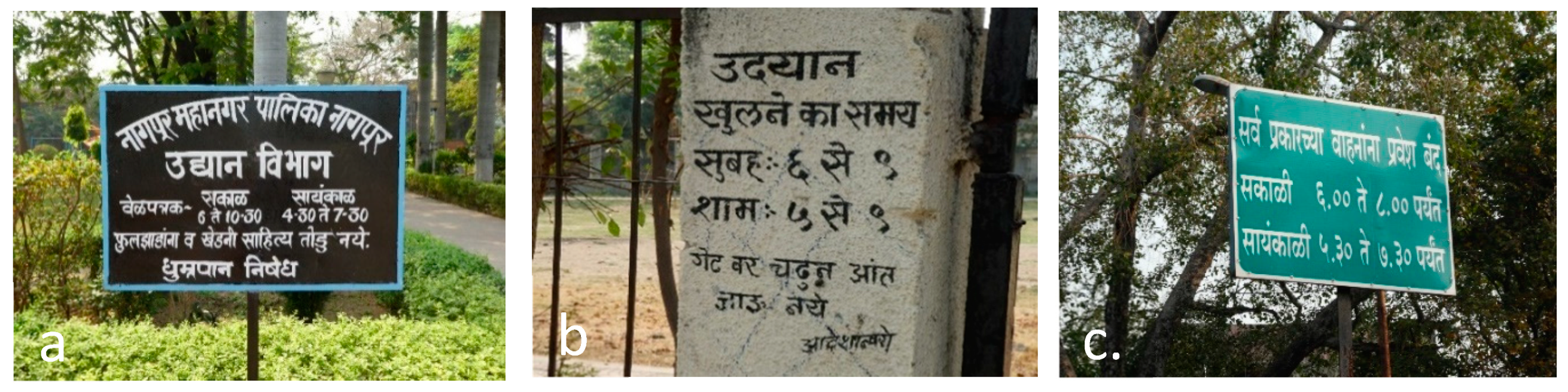
2.5. Added Attributes
2.6. Methodology of Mapping
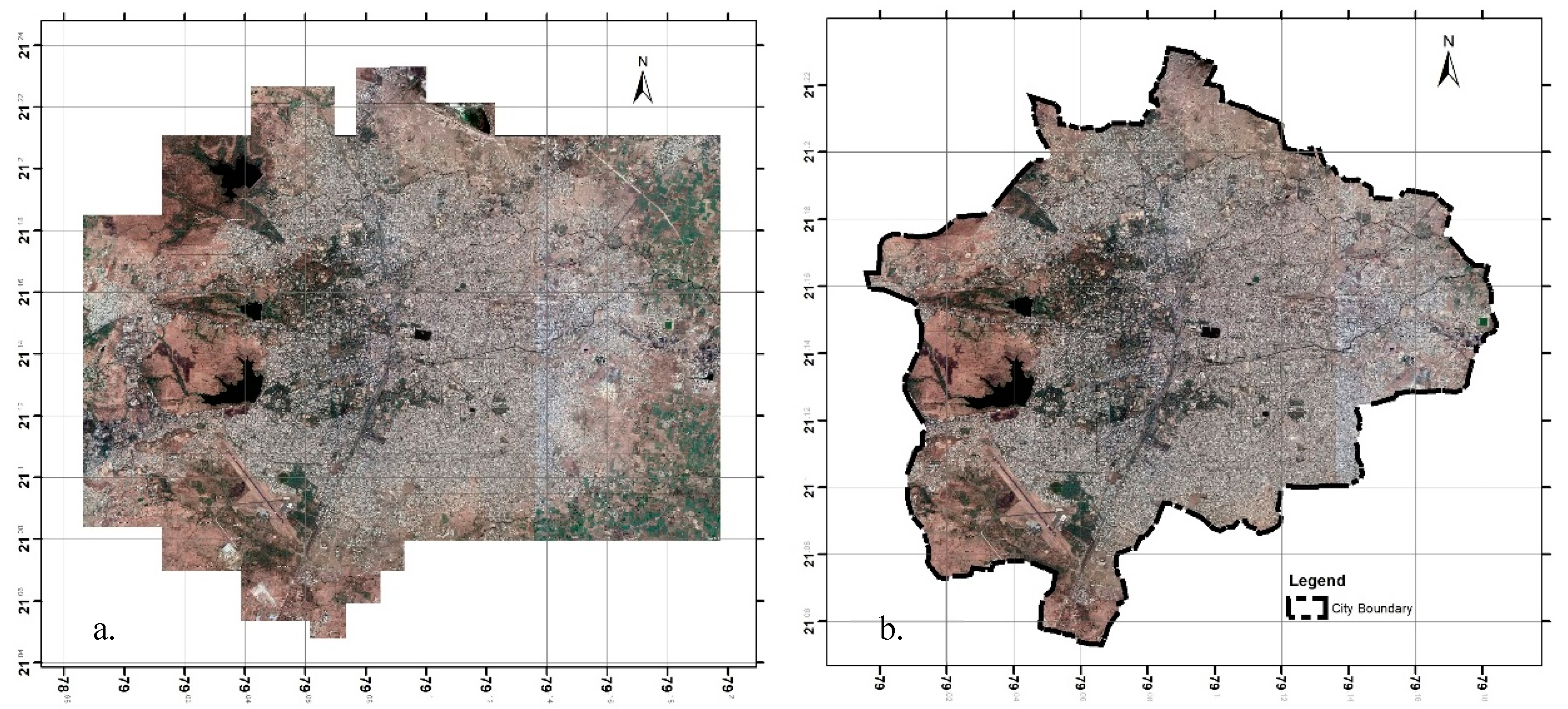
2.6.1. High Resolution Georeferenced Google Earth Imagery (GEI)
2.6.2. Vector Mapping of UGS in ArcGIS
2.6.3. Field Survey Data and Reference Map
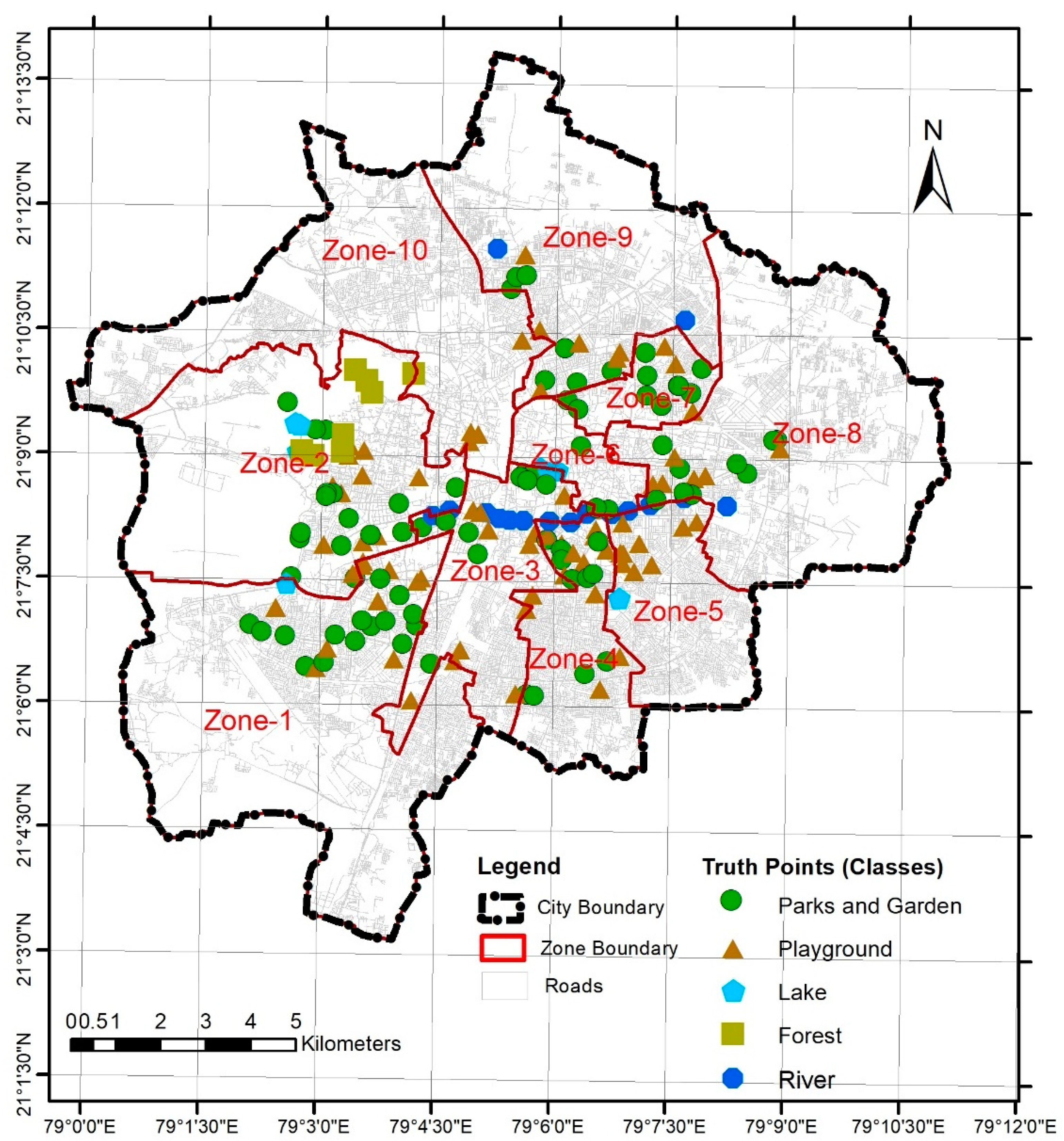
2.6.4. Validation and Accuracy Assessment
3. Results
3.1. Accuracy and Validity of Thematic Map
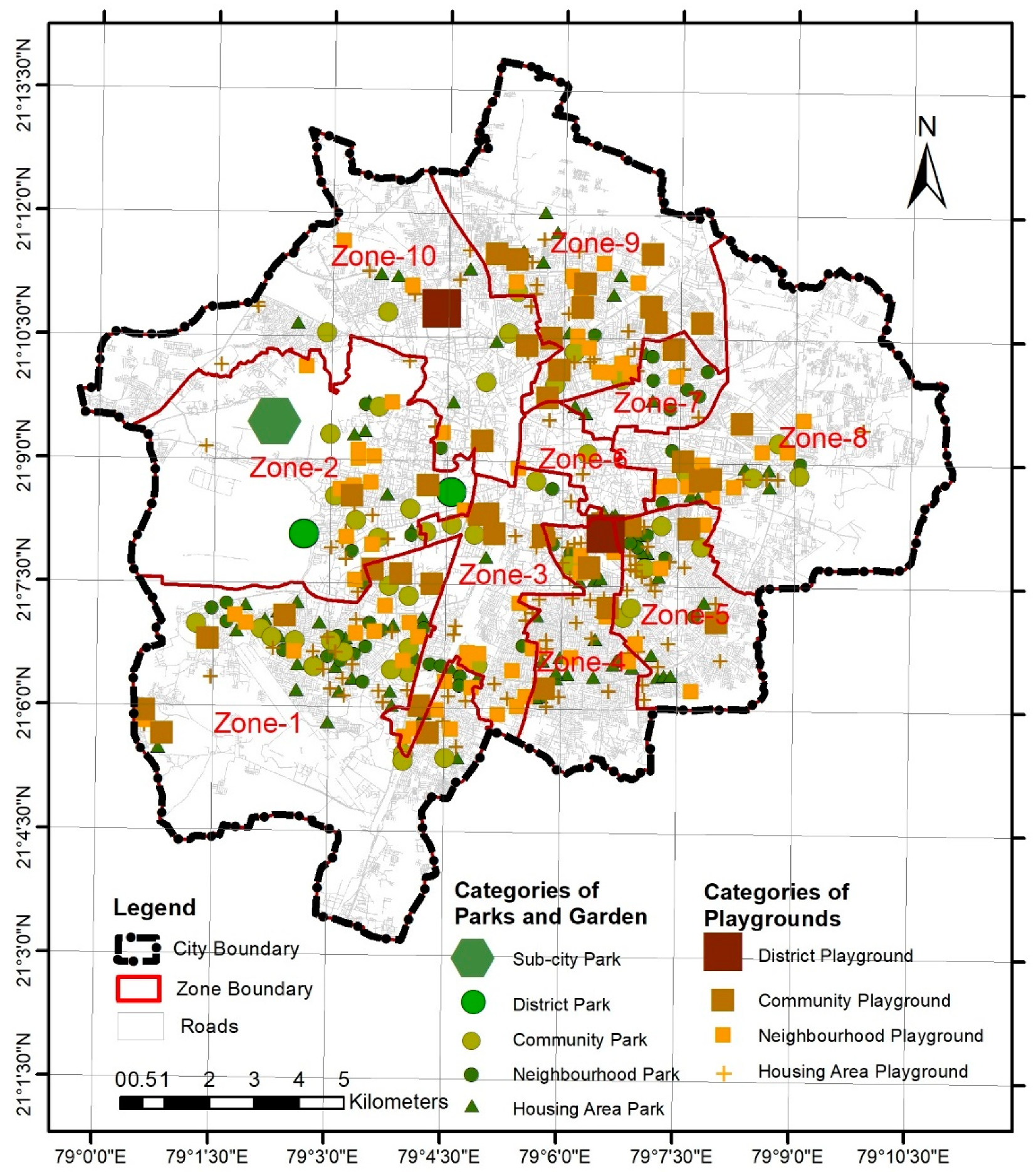
3.2. Different Categories of Public UGS Identified in Thematic Map
3.3. Status of UGS typologies
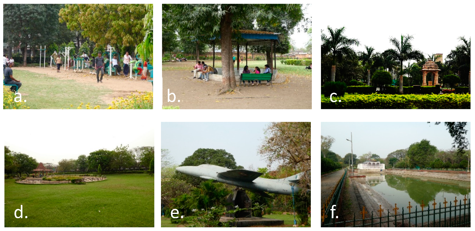
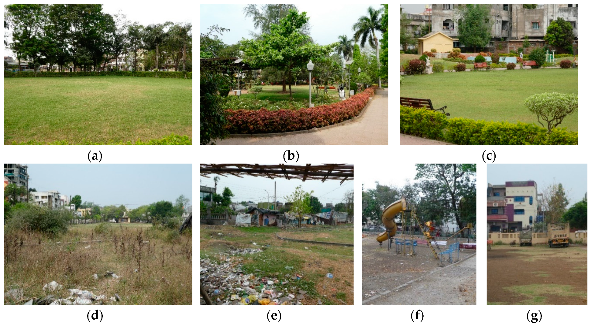
3.3.1. Recreational UGS Typology—Parks and Gardens
3.3.2. Recreational UGS Typology—Playgrounds
3.3.3. Recreational UGS Typology—Lakes
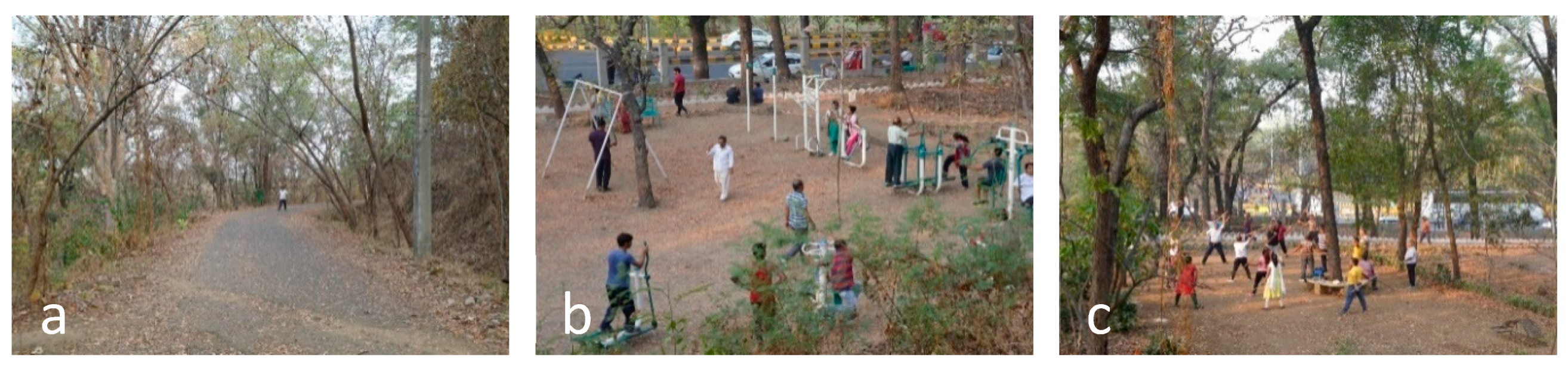
3.3.4. Recreational UGS Typology—Urban forest
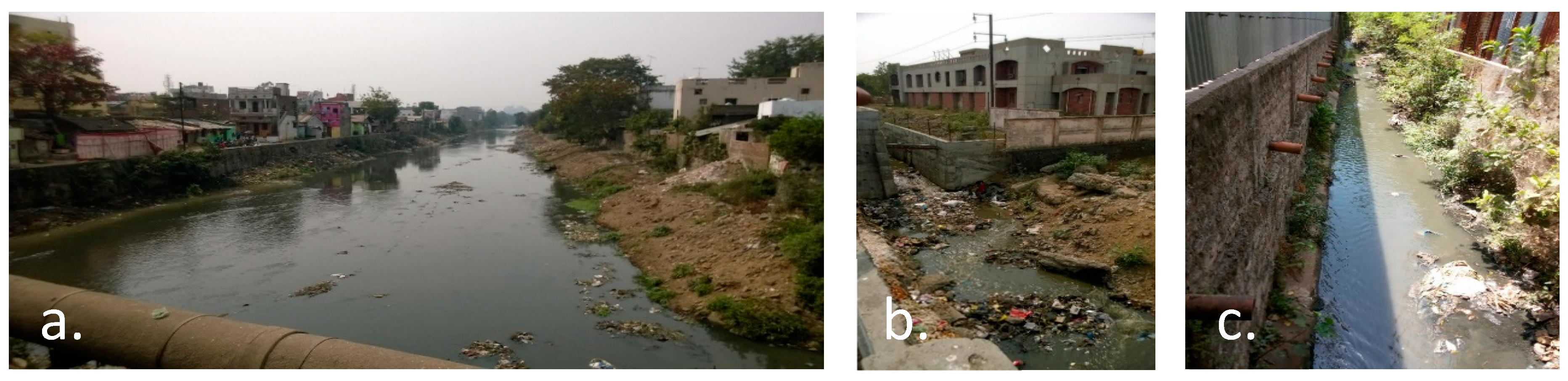
3.3.5. Open UGS Typology—River
3.3.6. Institutionalized UGS
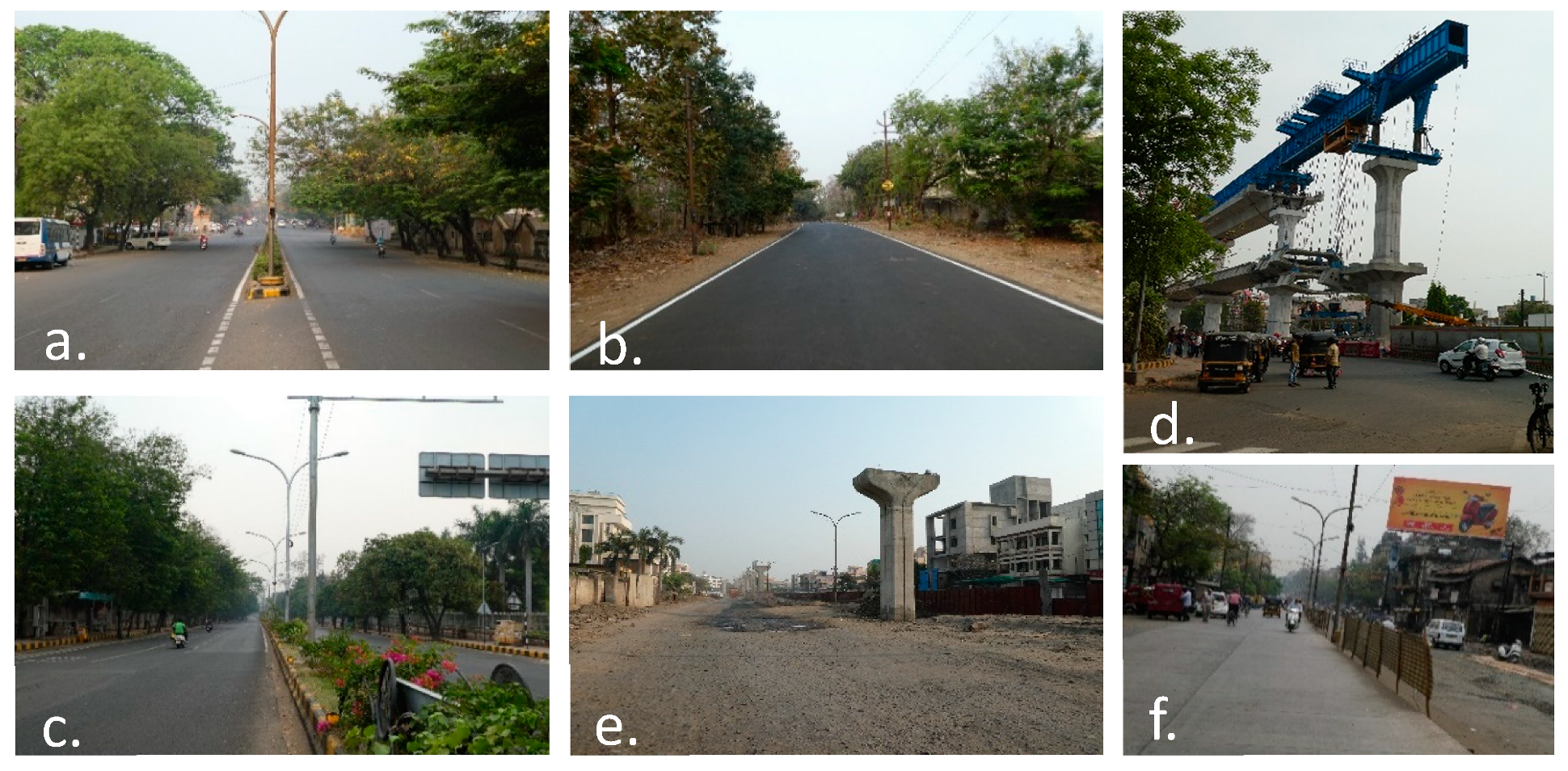
3.3.7. Infrastructure and Utility Corridor
3.3.8. Vacant Land
3.4. Distribution of Accessible Public UGS (Five Classes)
4. Discussion
5. Conclusions
Author Contributions
Funding
Acknowledgments
Conflicts of Interest
References
- Satterthwaite, D. Cities’ contribution to global warming: Notes on the allocation of greenhouse gas emissions. Environ. Urban. 2008, 20, 539–549. [Google Scholar] [CrossRef]
- UN-Habitat. World Cities Report 2016. Urbanization and Development: Emerging Futures; UN-Habitat: Nairobi, Kenya, 2016. [Google Scholar]
- McKinsey. India’s Urban Awakening: Building Inclusive Cities, Sustaining Economic Growth. 2010. Available online: https://www.mckinsey.com/featured-insights/urbanization/urban-awakening-in-india (accessed on 10 April 2019).
- ICLEI—South Asia. Green Growth Good Practices; ICLEI—Local Governments for Sustainability, South Asia: Delhi, India, 2015; Volume 3.
- Schetke, S.; Qureshi, S.; Lautenbach, S.; Kabisch, N. What determines the use of urban green spaces in highly urbanized areas?—Examples from two fast growing Asian cities. Urban For. Urban Green. 2016, 16, 150–159. [Google Scholar] [CrossRef]
- Alberti, M.; Marzluff, J.M.; Shulenberger, E.; Bradley, G.; Ryan, C.; Zumbrunnen, C. Integrating humans into ecology: Opportunities and challenges for studying urban ecosystems. BioScience 2003, 53, 1169–1179. [Google Scholar] [CrossRef]
- Rao, P.; Puntambekar, K. Evaluating the Urban Green Space benefits and functions at macro, meso and micro level: Case of Bhopal City. Int. J. Eng. Res. Technol. 2014, 3, 359–369. [Google Scholar]
- Gómez-Baggethun, E.; Barton, D.N. Classifying and valuing ecosystem services for urban planning. Ecol. Econ. 2013, 86, 235–245. [Google Scholar] [CrossRef]
- Kabisch, N.; Qureshi, S.; Haase, D. Human-environment interactions in urban green spaces—A systematic review of contemporary issues and prospects for future research. Environ. Impact Assess. 2015, 50, 25–34. [Google Scholar] [CrossRef]
- Tzoulas, K.; Korpela, K.; Venn, S.; Yli-Pelkonen, V.; Kazmierczak, A.; Niemela, J.; James, P. Promoting ecosystem and human health in urban areas using green infrastructure: A literature review. Landsc. Urban Plan. 2007, 81, 167–178. [Google Scholar] [CrossRef]
- Bhaskar, P. Urbanization and Changing Green Spaces in Indian Cities (Case Study—City of Pune). Int. J. Geol. Earth Environ. Sci. 2012, 2, 148–156. [Google Scholar]
- Dallimer, M.; Davies, Z.G.; Diaz-porras, D.F.; Irvine, K.N.; Maltby, L.; Warren, P.H.; Armsworth, P.; Gaston, K.J. Historical influences on the current provision of multiple ecosystem services. Glob. Environ. Chang. 2015, 31, 307–317. [Google Scholar] [CrossRef]
- Town & Country Planning Organisation. Urban Greening Guidelines; Ministry of Urban Development, Government of India: New Delhi, India, 2014.
- Troy, A.; Wilson, M.A. Mapping ecosystem services: Practical challenges and opportunities in linking GIS and value transfer. Ecol. Econ. 2006, 60, 435–449. [Google Scholar] [CrossRef]
- Meyer, B.; Grabaum, R. MULBO—Model framework for multi critieria landscape assessment and optimisation. A support system for spatial land use decisions. Landsc. Res. 2008, 33, 155–179. [Google Scholar] [CrossRef]
- Groot, R.S.D.; Alkemade, R.; Braat, L.; Hein, L.; Willemen, L. Challenges in integrating the concept of ecosystem services and values in landscape planning, management and decision making. Ecol. Complex. 2010, 7, 260–272. [Google Scholar] [CrossRef]
- Clarke, K. Analytical and Computer Cartography, 2nd ed.; Prentice Hall: Upper Saddle River, NJ, USA, 1995. [Google Scholar]
- Muyphy, E.; King, E.E. Mapping for sustainability: Environmental noise and the city. In Methods of Sustainability Research in the Social Sciences; Sage: Newcastle upon Tyne, UK, 2013; 232p. [Google Scholar]
- Yusof, M.J.M. The True Colours of Urban Green Spaces: Identifying and Assessing the Qualities of Green Spaces in Kuala Lumpur, Malaysia; Institute of Geography, University of Edinburgh: Edinburgh, UK, 2012. [Google Scholar]
- Dennis, M.; Barlow, D.; Cavan, G.; Cook, P.; Gilchrist, A.; Handley, J.; James, P.; Thompson, J.; Tzoulas, K.; Wheater, C.P.; et al. Mapping Urban Green Infrastructure: A Novel Landscape-Based Approach to Incorporating Land Use and Land Cover in the Mapping of Human-Dominated Systems. Land 2018, 7, 17. [Google Scholar] [CrossRef]
- Gupta, K.; Sharma, K.P.; Krishnamurthy, Y.V.; Kolapkar, R. FUNCTIONAL ASSESSMENT OF URBAN GREEN SPACES SPACES—A GIS ANALYSIS. In Proceedings of the 12th ESRI India User Conference, Noida, India, 7–8 December 2011. [Google Scholar]
- Gopal, S.; Woodcock, G. Theory and Methods for Accuracy Assessment of Thematic Maps Using Fuzzy Sets. Photogramm. Eng. Remote Sens. 1994, 60, 181–188. [Google Scholar]
- Sreetheran, M.; Adnan, M. Green network development of Kuala Lumpur City: From the perspective of Kuala Lumpur Structure Plan. Int. J. Postgrad. Stud. Archit. Plan. Landsc. 2007, 7, 38–41. [Google Scholar]
- Kafafy, N. The Dynamics of Urban Green Space in an Arid City: The Case of Cairo-Egypt; UMI Number: U584501; Cardiff University: Cardiff, UK, 2010; Available online: http://orca.cf.ac.uk/54400/1/U584501.pdf (accessed on 10 December 2017).
- Tan, P.; Wang, J.; Sia, A. Perspectives on five decades of the urban greening of Singapore. Cities 2013, 32, 24–32. [Google Scholar] [CrossRef]
- CABE Space. Urban Green Nation: Building the Evidence Base; CABE Space: London, UK, 2010. [Google Scholar]
- Tyrväinen, L.; Mäkinen, K.; Schipperijn, J. Tools for mapping social values of urban woodlands and other green areas. Landsc. Urban Plan. 2007, 79, 5–19. [Google Scholar] [CrossRef]
- Tran, H.; Pham, K.C. GIS-Based Management of Urban Tree and Green Spaces in Vietnam Cities. 2012. Available online: http://www.yepat.uni-greifswald.de/greenercities/images/stories/PDFs/8.pdf (accessed on 13 September 2018).
- Hassan, M.M.; Southworth, J. Analyzing Land Cover Change and Urban Growth Trajectories of the Mega-Urban Region of Dhaka Using Remotely Sensed Data and an Ensemble Classifier. Sustainability 2018, 10, 10. [Google Scholar] [CrossRef]
- Surawar, M.; Kotharkar, R. Environmental Impact Assessment in Urban Fringe to Achieve Urban Sustenance. In Proceedings of the International Conference on Advances in Architecture and Civil Engineering (AARCV 2012), Bangalore, India, 21–23 June 2012. [Google Scholar]
- Anguluri, R.; Narayanan, P. Role of green space in urban planning: Outlook towards smart cities. Urban For. Urban Green. 2017, 25, 58–65. [Google Scholar] [CrossRef]
- Surawar, M.; Kotharkar, R. Assessment of Urban Heat Island through Remote Sensing in Nagpur Urban Area Using Landsat 7 ETM+. Int. J. Civ. Environ. Struct. Constr. Archit. Eng. 2017, 11, 851–857. [Google Scholar]
- Verma, S.R.; Chaudhari, P.R.; Singh, R.K.; Wate, S.R. Studies on the Ecology and Trophic Status of an Urban Lake at Nagpur City, India. Rasayan J. Chem. 2011, 4, 652–659. [Google Scholar]
- Dhyani, S.; Lahoti, S.; Khare, S.; Pujari, P.; Verma, P. Ecosystem based Disaster Risk Reduction approaches (EbDRR) as a prerequisite for inclusive urban transformation of Nagpur City, India. Int. J. Disaster Risk Reduct. 2017, 32, 95–105. [Google Scholar] [CrossRef]
- Coles & Grayson. Improving the Quality of Life in Urban Regions though Urban Greening Initiatives-EU URGE-Project. 2004. Available online: https://www.researchgate.net/publication/237553539_Improving_the_Quality_of_Life_in_Urban_Regions_Through_Urban_Greening_Initiatives_-_EU_URGE-Project (accessed on 12 December 2017).
- Rozenstein, O.; Karnieli, A. Comparison of methods for land-use classification incorporating remote sensing and GIS inputs. Appl. Geogr. 2011, 31, 533–544. [Google Scholar] [CrossRef]
- Hay, A.M. Sampling designs to test land-use map accuracy. Photogramm. Eng. Remote Sens. 1979, 45, 529–533. [Google Scholar]
- Mas, J.F.; Azucena, P.V.; Adrián, G.; Silvia, M.; Jaime, O.; Ernesto, V. A Suite of Tools for Assessing Thematic Map Accuracy. Geogr. J. 2014, 2014, 372349. [Google Scholar] [CrossRef]
- Congalton, R.G.; Green, K. Assessing the Accuracy of Remotely Sensed Data: Principles and Practices, 2nd ed.; CRC Press: Boca Raton, FL, USA, 2009. [Google Scholar]
- Lang, S. Object-based image analysis for remote sensing applications: Modelling reality—Dealing with complexity. In Object Based Image Analysis; Springer: Heidelberg/Berlin, Germany; New York, NY, USA, 2008; pp. 1–25. [Google Scholar]
- Liu, Y.; Meng, Q.; Zhang, J.; Zhang, L.; Jancso, T.; Vatseva, R. An effective Building Neighborhood Green Index model for measuring urban green space. Int. J. Digit. Earth 2015, 9, 387–409. [Google Scholar] [CrossRef]
- Ministry of Urban Development. City Development Plan for Nagpur, 2041; Government of India: New Delhi, India, 2015.
- Katpatal, Y.B.; Kute, A.; Satapathy, D.R. Surface- and Air-Temperature Studies in Relation to Land Use/Land Cover of Nagpur Urban Area Using Landsat 5 TM Data. J. Urban Plan. Dev. 2008, 134, 110–118. [Google Scholar] [CrossRef]
- Chaturvedi, A.; Kamble, R.; Patil, N.G.; Chaturvedi, A. City–forest relationship in Nagpur: One of the greenest cities of India. Urban For. Urban Green. 2013, 12, 79–87. [Google Scholar] [CrossRef]
- Govindarajulu, D. Urban green space planning for climate adaptation in Indian cities. Urban Clim. 2014, 10, 35–41. [Google Scholar] [CrossRef]
- Fahy, F.; O’Cinneide, M. Re-constructing the urban landscape through community mapping: An attractive prospect for sustainability. Area 2009, 41, 167–175. [Google Scholar] [CrossRef]
- Bhonsle, K.D.; Adane, V.S. Status of Childrens Outdoor Play in Urban Settings-Casestudy-Nagpur [Maharashtra, India]. Am. J. Civ. Eng. Archit. 2015, 3, 200–207. [Google Scholar]
- Lanjewar, K.Y.; Kelkar, P.S. Studies on Rejuvenation of Futala Lake, Nagpur. In Proceedings of the 12th World Lake Conference, New Delhi, India, 29 October–2 November 2007. [Google Scholar]
- Gupta, R.B.; Chaudhari, P.; Wate, S.R. Floristic diversity in urban forest area of NEERI Campus, Nagpur, Maharashtra (India). J. Environ. Sci. Eng. 2008, 50, 55–62. [Google Scholar]
- Kumar, M.; Tripathi, D.K. Spatial Monitoring of Urban Growth of Nagpur City (India) Using Geospatial Techniques. J. Settl. Spat. Plan. 2014, 5, 91–98. [Google Scholar]
- Rosa, D.L. Accessibility to green spaces: GIS based indicators for sustainable planning in a dense urban context. Ecol. Indic. 2014, 42, 122–134. [Google Scholar] [CrossRef]
- Khalil, R. Quantitative evaluation of distribution and accessibility of urban green spaces (Case study: City of Jeddah). Int. J. Geomat. Geosci. 2014, 4, 526–535. [Google Scholar]
- Comber, A.; Brunsdon, C.; Green, E. Using a GIS-based network analysis to determine urban greenspace accessibility for different ethnic and religious groups. Landsc. Urban Plan. 2008, 86, 103–114. [Google Scholar] [CrossRef]
- Nicholls, S. Measuring the accessibility and equity of public parks: A case study using GIS. Manag. Leis. 2001, 6, 201–219. [Google Scholar] [CrossRef]
- Braquinho, C.; Cvejić, R.; Eler, K.; Gonzales, P.; Haase, D.; Hanse, R.; Kabisch, N.; Rall, E.L.; Niemela, J.; Paulei, S.; et al. A Typology of Urban Green Spaces, Ecosystem Services Provisioning Services and Demand. Green Surge, Report: D3.1. 2015. Available online: https://greensurge.eu/working-packages/wp3/files/D3.1_Typology_of_urban_green_spaces_1_.pdf/D3.1_Typology_of_urban_green_spaces_v2_.pdf (accessed on 25 March 2018).
- Burkhard, B.; Maes, J. Mapping Ecosystem Services; Pensoft Publishers: Sofia, Bulgaria, 2017; 374p. [Google Scholar]
- Convertino, M.; Muneepeerakul, R.; Azaele, S.; Bertuzzo, E.; Rinaldo, A.; Rodriguez-Iturbe, I. On neutral metacommunity patterns of river basins at different scales of aggregation. Water Resour. Res. 2009, 45. [Google Scholar] [CrossRef]
- Convertino, M.; Muñoz-Carpena, R.; Chu-Agor, M.L.; Kiker, G.A.; Linkov, I. Untangling drivers of species distributions: Global sensitivity and uncertainty analyses of MaxEnt. Environ. Model. Softw. 2014, 51, 296–309. [Google Scholar] [CrossRef]


| Sn. | Data | Data Source |
|---|---|---|
| 1 | NMC-City Boundary | NMC * |
| 2 | Zone Boundaries | NMC |
| 3 | Ward Boundaries | NMC |
| 4 | Land use Map | NMC |
| Sn. | Public UGS Typology | Green Space Classes | Remark |
|---|---|---|---|
| 1 | Recreational UGS | Parks and garden | Direct and indirect recreation |
| Playground | |||
| Lakes | |||
| Forest | |||
| 2 | Open UGS | River | Currently degraded and serves as sewer channel but has an ambitious rejuvenation plan for future recreational corridor |
| 3 | Public institutionalized GS | Government institutions | Restricted access but are important and influential presence in urban set-up |
| Government campus (housing and offices) | |||
| 4 | Infrastructure and utility corridor | Road network | Mapping of green spaces not done however form important part of networking various green spaces |
| 5 | Vacant land | Vacant land in the peripheries | Vacant plots under residential land use which are subject to change |
| S. No. | Category | No. of Parks Required Unit | Unit Area in Ha |
|---|---|---|---|
| 1 | Sub-city | 1 for 1,000,000 population | 100 |
| 2 | District | 1 for 500,000 population | 25 |
| 3 | Community | 1 for 100,000 population | 5 |
| 4 | Neighborhood | 1 for 15,000 population | 1 |
| 5 | Housing area | 1 for 5000 population | 0.5 |
| Attributes | Classification | Data Source |
|---|---|---|
| Zone | 10 zones (Zone1, Zone2, Zone3, Zone4, Zone5, Zone6, Zone7, Zone8, Zone9, Zone10) | Local authority |
| Ward | 136 wards (1,2,3,4 up to 136) | Local authority |
| Land use | Recreation, Waterbodies, Forest, Public-semipublic, Vacant land, Transportation | Land use plan |
| UGS Classes | Parks and Garden (1), Playground (2), Lake (3), Hills (4), River (5), Vacant land (6), Institutional Open space (7), Road network (8) | Derived from land use plan |
| Ownership | NMC, Governing Body, Forest Department | Land use plan and local authority |
| Vegetation | No, Scrub (low)-Peripheral, Sparse (low-medium)-Manicured, Coarse (medium-high) | Author (field observations) |
| Scale | Housing area, Neighborhood, Community, District, Sub city | URDPFI guidelines |
| Access | Limited, Restricted, No, Open, Paid | Author (field observations) |
| Name | Given | Local authority |
| Maintenance | Maintained, Not maintained | Author (field observations) |
| Area | Area in hectares | ArcGIS (calculate geometry tool) |
| Reference Data or Ground Truth Classes | |||||||
|---|---|---|---|---|---|---|---|
| Classification | Parks and Garden | Playground | Lake | Forest | River | Row Total | User’s acc. |
| Parks and garden | 77 | 0 | 0 | 0 | 0 | 77 | 100% |
| Playground | 0 | 74 | 0 | 0 | 0 | 74 | 100% |
| Lake | 3 | 0 | 8 | 0 | 0 | 11 | 73% |
| Forest | 2 | 1 | 1 | 8 | 0 | 12 | 67% |
| River | 2 | 0 | 0 | 0 | 16 | 18 | 89% |
| Column total | 84 | 75 | 9 | 8 | 16 | 192 | |
| Producer acc. | 92% | 99% | 89% | 100% | 100% | ||
| Overall acc. | 95% | ||||||
| Points sampled (n) | 192 | ||||||
| Kappa coefficient | 93% | ||||||
| Sn. | Category | Count (Parks and Garden) | Area in ha (Parks and Garden) | Count (Playground) | Area in ha (Playground) |
|---|---|---|---|---|---|
| 1 | Sub-city | 1 | 50.00 | - | - |
| 2 | District | 2 | 31.00 | 2 | 22.00 |
| 3 | Community | 45 | 89.00 | 39 | 44.00 |
| 4 | Neighborhood | 46 | 33.00 | 76 | 53.00 |
| 5 | Housing area | 85 | 30.00 | 117 | 41.00 |
© 2019 by the authors. Licensee MDPI, Basel, Switzerland. This article is an open access article distributed under the terms and conditions of the Creative Commons Attribution (CC BY) license (http://creativecommons.org/licenses/by/4.0/).
Share and Cite
Lahoti, S.; Kefi, M.; Lahoti, A.; Saito, O. Mapping Methodology of Public Urban Green Spaces Using GIS: An Example of Nagpur City, India. Sustainability 2019, 11, 2166. https://doi.org/10.3390/su11072166
Lahoti S, Kefi M, Lahoti A, Saito O. Mapping Methodology of Public Urban Green Spaces Using GIS: An Example of Nagpur City, India. Sustainability. 2019; 11(7):2166. https://doi.org/10.3390/su11072166
Chicago/Turabian StyleLahoti, Shruti, Mohamed Kefi, Ashish Lahoti, and Osamu Saito. 2019. "Mapping Methodology of Public Urban Green Spaces Using GIS: An Example of Nagpur City, India" Sustainability 11, no. 7: 2166. https://doi.org/10.3390/su11072166
APA StyleLahoti, S., Kefi, M., Lahoti, A., & Saito, O. (2019). Mapping Methodology of Public Urban Green Spaces Using GIS: An Example of Nagpur City, India. Sustainability, 11(7), 2166. https://doi.org/10.3390/su11072166