Abstract
As a vital historic neighborhood with an indeterminate large-scale planning scheme, Yingping, located in the city center of Xiamen, China, is struggling with poor livability and growing incoherent private additions and renovations that largely undermine the local historic urban landscape. Inspired by Italian typology- and morphology-led planning techniques, this study explores the possible interpretations and implications of their applications in Yingping to address its interconnected, heterogeneous, and stratified urban fabric and planning problems. The research is developed through a two-pronged multi-layered planning framework. Firstly, from the maintenance perspective, five intervention approaches are grouped, with a specific focus on the leading structural elements of the urban fabric—the arcade streets. Secondly, from the morphological view and through the ecological lens, six characterized areas are identified and classified with respective morphological features and crucial planning problems being faced. This framework provides a strategic thematization of corresponding optimizing strategies and suitable guidelines to direct future governmental actions and to support the self-maintenance of local inhabitants toward sustainable development. The study also presents the possibility that such techniques are applicable to the Chinese context and is expected to inspire further research and practices in China and beyond.
1. Introduction
Despite the increased focus on urban conservation, many historic areas still face tremendous planning challenges and await suitable strategies. In China, many historic urban quarters were displaced by either urban development projects or pseudo-historical touristic districts since the early 1980s. Located in the city center, the Yingping historic quarter is one of few areas that remains a thriving and vital neighborhood with the lack of a large-scale definite planning scheme. The area is struggling with poor livability and increasing numbers of haphazard and incoherent private additions and renovations that largely undermine the local historic urban landscape.
As one of the most popular tourist destinations in the world, Italy has the most World Heritage Sites as of July 2018. The Italian approach of urban development is summarized as “redevelopment by tradition” with “a slow and organic piece-by-piece development process” [1]. In Italy, the many historic settlements present coherent and consistent townscapes without the dominance of modern developments. Not only due to its specific culture of conserving heritage, the Italian tradition of urban conservation is based on long-term theoretical and practical experimentation [2,3,4,5,6,7]. There are some relevant narratives and discussions on Italian Journal of Planning Practice [8,9] and Planum [5,10]. In particular, the technical exploration since the 1950s is deemed as one of the most important and meaningful contributions by this country to the international field of urban planning [7,11]. To a large extent, such contributions are worthy of international study, since they may provide useful references for non-Italian contexts and valuable elements for the international disciplinary debate, particularly on the conservation and enhancement of historic centers and cities [8]. Looking more closely at the Italian legacy, typology- and morphology-led planning techniques made a significant methodological contribution to the technical experimentation [12,13,14]. These techniques provide an effective and convincing lens for understanding the urban stratification process and further addressing the interconnected and overlapped heterogeneous physical and social situations, as well as planning challenges [12,13,14,15].
The article continues from this introduction with a review of the relevant literature. The third section explains the origins and differences of Italian typology- and morphology-led planning techniques and discusses the possible applications to historic quarters in other contexts, like Yingping. Section 4 illustrates the basic situation of Yingping and the relevant research methods. Section 5 presents the results, identifying five intervention groups and six characterized areas, grouping issues and problems and discussing respective optimizing methods to address the issues. The paper ends with an overall discussion and summary of some findings and reflections about the significance and implications of the study, particularly presenting a comparison with the research of Gulangyu Island, together with recommendations for future improvements.
2. Literature Review
Much of the existing research relating to urban conservation and regeneration of China focuses on several key topics: the historical development process of urban conservation and regeneration in China in the context of the transforming political–economic conditions [16,17,18]; the interpretation and implication of international principles and ideas of heritage conservation and management in the Chinese context, such as the Burra Charter [19,20], the idea of authenticity [21,22,23,24], and the concept of historic urban landscape [24,25,26]; the role of governments in facilitating the revitalization of dilapidated historic quarters and generating politico-economic benefits [27,28,29,30,31], especially through cooperation with real-estate developers [32,33] and through the pursuit of World Heritage listing [15,34,35]; social capital, public participation, and interaction of regenerating and conserving historic quarters [36,37,38,39,40]; the transformation of spatial structures and urban forms in historic areas [41,42]; and the indicators for assessing the sustainability of built heritage [43,44].
Despite the recent growth in the research of urban conservation and regeneration of China in the international debate, many scholars think that the overall amount and the depth still remain insufficient [38,45], especially in introducing and applying advanced Western technical methods into China [15]. In particular, the Italian technical methods, dominated by the typology- and morphology-led planning techniques, are little applied in China [15]. The severely limited research includes a typo-morphological interpretation in English about Gulangyu Island [15], and a primary study in Italian about the former French concession of Tianjin [46]. Overall, such techniques are largely understudied in non-Italian contexts to date. If any, explorations tend to center on Latin American and Islamic countries [6,47,48]. In the international debate, the techniques were only involved in some general and brief introductions [5,6,10,49] and the discussion of several milestone projects, e.g., Bologna [50].
The study of urban morphology underwent remarkable development since the post-war period with increasing international attention from multiple disciplines, such as human geography (see Conzen and his British school), architecture and urban design (see the Italian Muratori–Caniggia school), the utopian approach in the search for ideal cities (e.g., Le Corbusier, Howard, and Wright), and anthropology (e.g., Lynch, Jacobs, and Alexander) [51]. The perspective of urban design and architecture is predominately related to the research outputs of the Italian Muratori–Caniggia school [52,53], particularly a series of exploration developed by this school in the 1950s and 1960s, such as Muratori’s study of Venice and Rome [54,55] and Caniggia’s research of Como [56]. Through drawing a series of typological maps of different historic periods, the school aimed at understanding the diachronic evolution process of buildings and built spaces to guide new urban design projects for re-forming the post-war built environment. The typological maps refer to the ground-floor plans of buildings and built spaces in historic centers and areas, and their prototype could be regarded as the Nuova Pianta di Roma (the New Plan of Rome, commonly known as the Nolli Map) in 1748. The Nolli Map was composed of 12 copper-plate engravings about the city and buildings of Rome and presented the urban forms through a figure-ground representation of the ground-floor plan of built spaces, where private blocks and buildings were shaded in a dark poché, and streets, squares, and public buildings were remained in blank. Although the school is also called the Italian Urban Morphological School, it primarily centers around typological study through the bit-by-bit analysis of single buildings and their aggregated urban forms. The international studies published from this school in the Chinese context focus more on the typical analysis of buildings’ evolution process in some well-known Chinese historic cities, such as Suzhou, Shanghai, and Guangzhou [57,58,59,60].
A wider framework and some innovative and far-reaching contributions made by Lynch and Debord in the 1960s are worthy of mention, for instance, Lynch’s research of urban forms, urban image, and imageability, particularly his application of mental maps in the field of urban study [61]. Similarly, Debord, who led the situationists, proposed the notion of the dérive (the drift), referring to an unplanned journey through the urban landscape that was navigated by the individual’s emotional reaction to the surrounding urbanscape [62]. Through the observation and mapping of a city in the psychogeographical perspective (see the example of Psychogeographical Guide of Paris), the situationists highlighted the importance of maintaining the link with the cities’ historical past [63].
Some recent works about how to apply these 1960s urban morphology theories and approaches into the contemporary urban context also need attention, such as the morphological analysis of (new) urban forms and changing landscape occurred in urban peripheral areas and urban sprawl territories [64], and the development of new approaches, for instance, the three-dimensional Urban Parterre Model to put the city’s street-level environment in a long-term development perspective as a practical guide for future interventions [65,66].
In summary, despite the increased interest in the research of urban morphology, the existing studies of Italian typology- and morphology-led planning techniques in non-Italian literature have limited breadth and depth, having little influence to date. In China, many historical cities and areas are faced with sustainable development challenges and pressure to maintain physical consistency. In response, this article explores possible interpretations and implications of applying Italian typology- and morphology-led planning techniques in the Chinese context and, more precisely, in the vital historic quarters like Yingping, which are being confronted with deteriorating living conditions and increasing numbers of haphazard and incoherent private additions and renovations that destroyed the local historic urban landscape.
3. Italian Typology- and Morphology-Led Planning Techniques: Development and Implication
The post-World War II (WWII) period, particularly the 1960s, is widely regarded “as a turning point in the principles of urban planning for the existing city” in Italy and as the time when “historic centers were born” [12,67]. The first event that witnessed historic centers receiving the attention of urban studies was the promulgation of the Charter of Gubbio (1960) [9]. From a technical point of view, the associated planning treatment for historic centers tended to work along two different tracks [5,10].
One modality, the typology-led planning technique, is based on a typological approach. Focusing on individual buildings, this approach treats architectural and historical values of historic centers as “residing in the characteristics of the individual buildings”, and deems that such characteristics, which “should be selected on the basis of typological criteria”, provide the ability to manage the interventions of historic centers [5]. This is related to the growing concern of building type in the postwar period, particularly along with the rise of the Italian Muratori–Caniggia school. Through the diachronic and synchronic analysis of building types, the school attempted to explain the structural continuity of traditional cities and further provided a non-arbitrary, powerful, and convincing reference for planning and design projects of historic centers and areas [68]. In general, the typology-led planning technique regards building types as the engine driving the interventions of historic centers. It follows specific typological rules to intervene and manage historic urban fabrics by single bits, which means treating individual buildings and their aggregated urban forms as a unit of intervention. The most well-known case is the revitalization of Bologna’s historic center in the 1970s [50,69].
Another modality, the morphology-led planning technique, is more concerned with the complex aggregates and individual constituent materials [5]. Through analyzing morphological features that shape urban sequences, groups of buildings, and portions of urban fabrics, this technique aims to identify morphological units or, more precisely, recognizable parts of urban landscape [5,12]. It also cares about the materials and elements of buildings and open spaces (e.g., fences, windows, doors, plaster coatings, etc.), since they compose the morphological vocabulary and create the image of historic areas [5,12]. The first significant application of this technique was the planning for Assisi during 1955 to 1958, which provided a comprehensive survey and description of morphological and social–economic features of the historic center for the first time, and included the care of common buildings and surrounding urban landscape, not solely monuments [14,70]. Following morphological rules, the plan included some proposals for guiding the re-arrangement of interior spaces and insertion of service units (e.g., stairs and bathrooms) for the purpose of meeting present living needs (Figure 1) [70]. The plan for Urbino’s historic center in the 1960s is widely regarded as a significant milestone for morphology-led planning practices for conserving historic centers in Italy. With the main concern being the homogeneity and similarity of the morphological features of the urban fabric, the plan divided the historic center of Urbino into 26 sectors and seven sub-sectors to establish a regulatory mechanism consisting of targeted intervention rules for each sector and sub-sector [71].
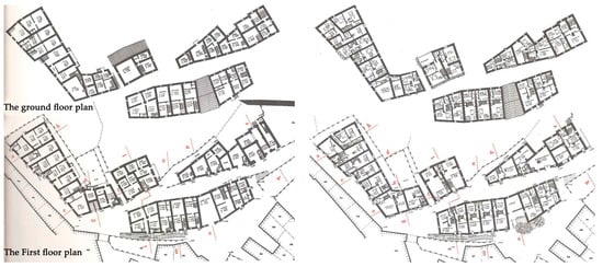
Figure 1.
The urban plan of Assisi, Italy: the re-arrangement of the interior space before (left) and after intervention (right). Source: translated and adapted from Astengo [70] (p. 109–110).
The morphology-led planning technique underwent further development in the last decades of the 20th century, although many practices are not well-known internationally and some were hardly involved in the Italian debate. For instance, the plan of Caltagirone in the 1980s outlined seven spheres of context (Figure 2) according to their homogeneous morphological features [72], including cathedrals, convents, palaces, houses, stores, public services, etc., the spheres involved the alignment of main streets and their surrounding building groups, the links between main and secondary streets, and between streets and facing building units. The typological analysis was developed in residential blocks, which were classified into 13 sectors (Figure 2). For each morphological sphere and typological sector, targeted planning strategies and rules were formulated.
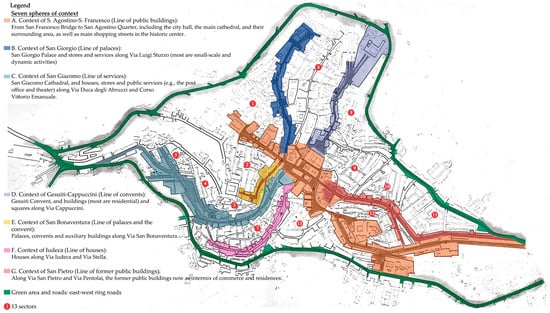
Figure 2.
The plan of Caltagirone, Italy: seven morphological spheres and 13 typological sectors. Source: translated and adapted from Leone, Iacona, Merlo, and Quartarone [72] (p. 72–73).
The plan of Schio around 1990 is worthy of attention. The project focused on a workers’ settlement with only about 100 years’ history rather than a traditional historic center. To address the destruction triggered by increasingly haphazard and inappropriate private additions and renovations since the 1970s, the plan identified five intervention categories (A–E) for the whole neighborhood according to the historic, cultural, and architectural value, with each block indexed by a sequential number (A1, A2, …) [73]. For each block and plot, a corresponding specific scheme of plans, sections, and facades was devised, involving precise guidelines for managing and controlling the variation in morphological elements of buildings and public spaces (Figure 3) [73]. Notably, the project produced a handbook that was distributed to local inhabitants (both owners and tenants) and the public for guiding and managing their addition and renovation actions.
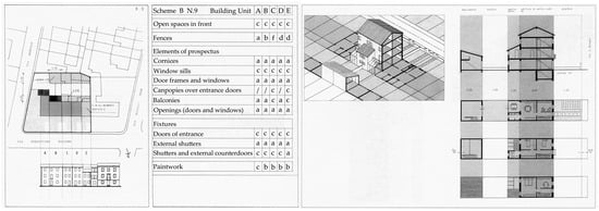
Figure 3.
The plan of Schio, Italy: the regulation scheme for Block B9. Source: translated and adapted from Mancuso [73] (p. 123).
To summarize, by focusing on bits of buildings, the typology-led planning technique enables working in more homogenous urban fabrics and structures, particularly those dominated by one or some specific building types. In contrast, through identifying recognizable parts, the morphology-led planning technique, more concerned about the aggregation of buildings and integral environment and urbanscape, seems more capable of addressing inhomogeneous, stratified, and interconnected urban fabrics and planning problems. As the case of Schio shows, through establishing a morphological grammatical system and recognizing the daily spatial practices of local dwellers, the morphology-led planning technique has the adaptive and adjusting capability to meet the changing needs of local inhabitants, helping to achieve dynamic conservation and sustainable development. Thus, from a practical point of view, the morphology-led planning technique is worthy of studying and following, especially as urban areas that lack many valuable buildings are facing increasing amounts of haphazard and incoherent private additions and renovations. The case of Yingping is a typical example.
4. Materials and Methods
4.1. Study Area
4.1.1. Geographic and Demographic Features
Located in the southwest of Xiamen Island in Fujian Province in southeast China, the quarter of Yingping covers about 25.42 ha. Dating back to the Ming Dynasty (1368–1644), Yingping is deemed as the birthplace of Xiamen. Since the end of the last century, Yingping has a high-density population and many poor low-rise dwellings (Figure 4). According to the last census in 2010, its population was approximately 22,027 and its density was 866 persons/ha, much higher than the average in the city of Xiamen (23 persons/ha) and Xiamen Island (134 persons/ha). The main function of the neighborhood is residential with commercial activities primarily distributed along main streets.
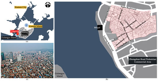
Figure 4.
(a) City of Xiamen and site of Yingping; (b) Yingping’s street structure and its surrounding environment; (c) aerial view of Yingping. Source: translated and adapted from School of Architecture, Huaqiao University [74].
4.1.2. Morphological and Typological Features
Except for some main streets, Yingping generally has a labyrinthine, stratified, heterogeneous, and high-density urban fabric (Figure 5), which may be attributed to the complex topographic condition, traditional customs, and long-term spatial practices, and some historic and social reasons. A morphological reading is presented through the discussion of the six characterized areas. Regarding typological features, there are three main building types (Figure 6): arcade building (Qilou), local courtyard house (Dacuo), and Western-style building (Yanglou). As its name implies, arcade buildings refer to those where a part of the ground floor comprises arcades and pedestrian walkways to keep off the rain and sun. Since the shop space is located on the ground floor and living space is on the upper floor, they are also called “shophouses” in English. They are mainly distributed in the coastal cities of southeast China (e.g., Quanzhou, Xiamen, Guangzhou, Hong Kong, Haikou, etc.) and southeast Asia (e.g., Malaysia, Singapore, etc.). In terms of Yingping, the arcade buildings, situated along main streets, are more plentiful than the other two and play a key role in shaping the local historic urban landscape (Figure 7). The distribution of the other two is more fragmented.
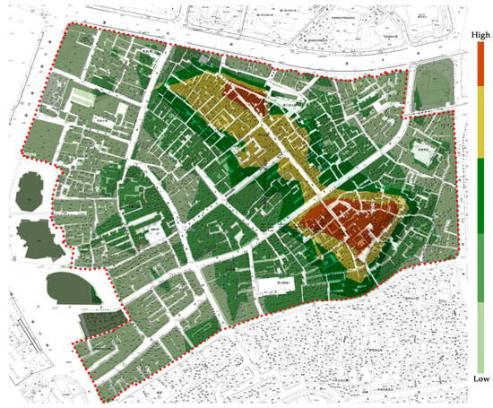
Figure 5.
The urban fabric and the height of terrain of Yingping.
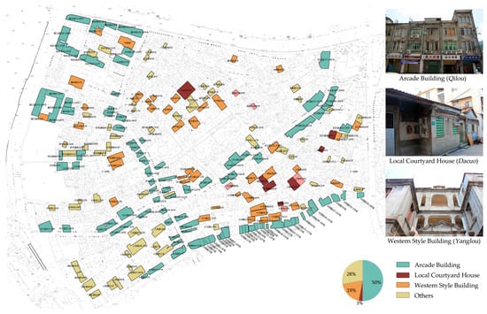
Figure 6.
The three main building types in Yingping. Source: translated and adapted from School of Architecture, Huaqiao University [74].
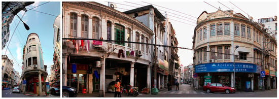
Figure 7.
The local historic urban landscape shaped by arcade buildings [75].
4.1.3. Planning Trajectory
A definite large-scale planning scheme for Yingping is yet to be developed. In 2006, the Municipal Planning and Design Institute proposed a regeneration plan, which included demolishing most historic buildings and replacing them with a mixed high-end commercial, financial, and tourist district. Due to the widespread criticism from both professionals and the public, the plan was suspended. In 2013, situated in Xiamen, Huaqiao University was invited by the local government to complete a physical survey of the neighborhood and provide proposals for regeneration [74]. A pilot project for the renovation of Lujiang Theater (called the Old Theater hereafter) and its surrounding public area was completed in 2015, which created a high-quality public space, the Old Theater Cultural Park (Figure 8). However, due to the change in relevant government leaders in 2015, these government-led planning actions were abandoned. Instead, a quite general guideline for controlling and managing private additions and renovations was proposed, claiming that new additions and renovations should maintain the same site, height, area of building(s), property, and relations to the surroundings as before.

Figure 8.
The renovated Old Theater Cultural Park.
As a reaction, in June 2015, the government of Siming District proposed some incentives for encouraging the self-maintenance and self-renovation actions of local inhabitants. For instance, financially, the sub-district government would pay the full price for creating a design proposal, 80% of the construction cost of facades, and 40% of interior reconstruction costs. Technically, some design institutes (e.g., the team from Huaqiao University) are committed to proposing designs and/or completing the construction. Until March 2016, 51 property owners applied to renovate their private buildings, covering the total area of 8696.5 m2 [76]. Most of them were located in the area surrounding the Old Theater Cultural Park. Their functions included museums, bookshops, coffee bars, galleries, local street food shops, and small restaurants. Overall, this approach enabled the reduction of economic pressures for local inhabitants and merchants when renovating their buildings, which motivated the local population to participate in the revitalization and maintenance of the local historic environment. Additionally, it facilitated not only the transformation and redevelopment of local traditional business, but also the inheritance of local history and culture.
4.1.4. Research Question
The existing restoration and conservation actions for Yingping only involved the six listed monumental buildings. Yingping’s ideal location with the accessibility to commercial centers, markets, wharfs, good schools, etc., and lower rent due to the poor-quality living environment, infrastructure, and buildings led to many low-income people moving in. Many of them completed many incoherent additions and renovations and inappropriate use of spaces, such as dividing living spaces into sub-units and adding services units in public spaces, which accelerated the deterioration of historic buildings and the holistic urban landscape. Thus, the research question of this case study is how to improve the neighborhood’s livability while maintaining the historic urban landscape toward sustainable development.
4.2. Research Method
The study is inspired by Italian typology- and morphology-led planning techniques and, more precisely, by the form and technical syntax of a series of aforementioned plans and planning devices. This involves, for instance, how to identify homogenous morphological units for creating targeted guidelines and strategies (see plans of Urbino and Caltagirone), and how to group intervention approaches from a maintenance-oriented perspective, and manage the variation in morphological elements through guiding private interventions (see the plan of Schio). The case of Schio is particularly worthy of examining, as, for both Schio and Yingping, the intervention aim is not the restoration and stylized recovery of historic appearance, but improving livability and maintaining and promoting the legibility and recognizability of the urbanscape language of the city. In Yingping, the typology-led planning technique is worth introducing in the spheres dominated by arcade buildings.
Another significant methodological reference is Banham’s ecological explanation for Los Angeles in 1971 [77]. By joining architecture to the idea of its ecology, Banham incorporated complex and interconnected physical elements, spatial practices, perceptions, and images of the territory into a clearly defined framework that consisted of four ecologies, each of which has connotative features [77,78]. This interpretation shows how to “break up irrevocably the normal homogeneity of architectural narratives and urban studies, insistently inserting the one into the other in a kind of montage” [78]. Such an interpretation of ecology was explored for use as a device for making plans, particularly since the 1990s. Many of these plans were formulated by Italian planers, such as the Territorial Plan of the Province of Pescara [79] and the Land-Use Plan of Reggio Emilia [80] in the 1990s, as well as the Structural Plans of Antwerp [81], Bologna [82], and Trieste [83] in the beginning of this century. In some of these plans, through the ecological lens, cities of cities were recognized and designed across a whole stratified city (e.g., the seven images and five strategic places of the Structural Plan of Antwerp and seven cities of the Structural Plan of Bologna), aiming at addressing the interconnected and overlapped physical and social situations and planning challenges of the new urban setting and growth.
It is also worth mentioning a recent re-interpretation of the ancient-Greek planning practices by Hippodamus. This re-interpretation discussed the exploration developed by Hippodamus on issues of cities and urban forms, pointed out through an innovative “zoning” plan Hippodamus realized the links between political or social control (population and activities) and spatial ordering, and “between plan and citizenship” for the first time [84]. The indicated interaction between the customs and practices of local inhabitants and the transformation of urban forms and spaces is worthy of attention, particularly when addressing the complex relationship among urban fabrics and forms, population, spatial practices, living behaviors, etc., as the case of Yingping shows.
In general, abovementioned “zoning” techniques and associated interpretations, based on the morphological perspective and the ecological lens, form the core logic of the research method of this study. The term “zoning” here is different from the conventional one that is based on the merely functional approach and widely used in modern urban planning as an unrefined and all-powerful tool shaping cities, but proved to be a failure in many urban contexts [15]. Instead, it is developed as a two-pronged multi-layered fertile planning framework (see the research framework in Figure 9). Firstly, from the maintenance-oriented perspective, five intervention approaches are grouped according to different grades of interventions to support and rule macro- and micro-interventions, with a specific focus on the leading structural elements of the urban fabric: the arcade streets. Secondly, from the morphological view and through the ecological lens, six characterized areas are identified and classified with respective morphological features and planning issues for discussing corresponding optimizing strategies and suitable guidelines.
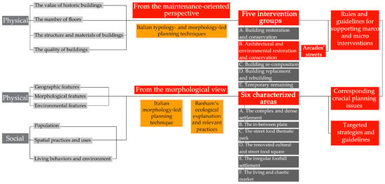
Figure 9.
Research framework.
5. Results
5.1. Yingping’s Five Intervention Groups
Based on the survey and analysis of the physical situation, including building structure and materials, quality, and number of floors, as well as the value of the historic buildings (Figure 10), five intervention approaches (Figure 11, Table 1) of Yingping were grouped involving different grades of building groups and their surrounding urban fabric and environment. Respective intervention aims and strategies were created in both the physical and social dimensions. Such interpretation was inspired by the identification of five intervention categories shown in the case of Schio. Among the five groups, a specific focus was on group B—arcade buildings and landscape—where building types may be treated as an engine driving intervention actions inspired by the Italian typology-led planning technique. The layered analysis of the arcade buildings and landscape is presented in Figure 12, incorporating the value and quality of historic buildings. Based on the analysis and a review of relevant practical research [85,86], possible strategies for treating arcade buildings and landscape are proposed, covering the macro and micro dimensions (Table 1). The findings suggest the need for creating a specific “zoning” plan for arcade buildings and landscape, across the neighborhood of Yingping and the surrounding area, and even the whole city.
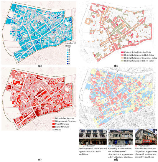
Figure 10.
The physical survey of the site: (a) the number of floors, (b) the value of historic buildings, (c) the structure and materials of buildings, and (d) the quality of buildings. Sources: (a) and (c) translated and adapted from Urbaneer [87]; (b) translated and adapted from School of Architecture, Huaqiao University [74].
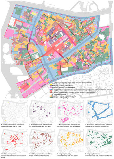
Figure 11.
Yingping’s five intervention groups.

Table 1.
Five intervention approaches and corresponding intervention strategies and rules.
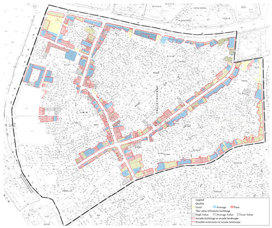
Figure 12.
The synthesis of the layered analysis of arcade buildings and landscape.
5.2. Yingping’s Six Characterized Areas
Mapping onto the aforementioned five intervention groups, six typical areas were identified (Figure 13, Table 2), according to relatively homogeneous geographic, physical, and sociological characteristics (with particular focus on the morphological features of built spaces through the history, quality of buildings and environment, customs, spatial practices, and activities, and living behaviors) and essential planning problems being faced. This interpretation was inspired by the Italian morphology-led planning technique and Banham’s ecological interpretation and relevant practical planning experiences. Here, the six areas can be deemed as entities that are the result of the encounter between space and society, urban materials and users, and the experiences of users.
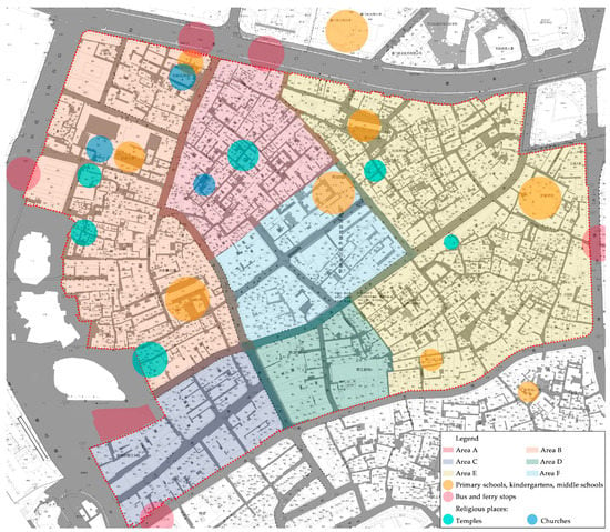
Figure 13.
Yingping’s six characterized areas.

Table 2.
The six characterized areas: features, issues, and strategies.
5.2.1. Area A: Complex and Dense Settlement
Dominated by living activities, Area A has the poorest living environment compared with other areas, which could be attributed to its many dense low-rise and low-quality local houses, as well as poor accessibility, few public spaces, and many haphazard and thoughtless additions. The morphological features reflect a spontaneous and high-density urban fabric across a hilly area (Figure 5), where many narrow and winding streets and lanes (1 to 3 m wide), dead-end roads, and T-junction streets are situated, creating a variable urban landscape. According to historic maps, cartographic records, and ancient text, the complex urban fabric can be dated back to the 18th century when a group of poor farmers from a nearby village settled here, creating these dead-end roads and T-junction streets for defending against bandits and pirates. Around the beginning of the 20th century, many brothels, tobacco houses, and theaters were located here due to its complex structure of streets and alleys, and proximity to wharfs. Most brothels and tobacco houses were banned after the Anti-Japanese War in 1945 and are presently abandoned and lack maintenance. In recent decades, and especially in the 1970s, many dead-end roads and T-junction streets were created by the haphazard and thoughtless private additions for expanding service units (e.g., kitchens, bathrooms, entrances for subleasing, etc.). Located in this dense area, churches and temples lack the necessary public spaces. Area A has few public spaces and, if any, their quality is low. To address these problems, additions and buildings to be demolished should be determined by completing a careful field survey (a primary reference is shown in Figure 10). That step should be accompanied by investigating which streets need to be cleared to reconnect streets and public spaces. An in-depth study of the historic evolution of the structure of streets and lanes and public spaces is required to guide the creation of a new mobility plan for the area. Also, to meet the needs of service spaces, technical and financial supports are suggested to provide for the appropriate re-arrangement and reuse of interior spaces, particularly for expanding service spaces. The plan of Assisi (Figure 1) is a valuable reference. The conservation and reuse of abandoned historic buildings must be carefully considered.
5.2.2. Area B: In-Between Plain
Compared with Area A, Area B generally manifests a vertical-oriented urban fabric to the water with fewer dead-end roads and T-junction streets (Figure 5). Most of the present inhabitants are descendants of early settlers from three ethnic sub-groups. With similar cultural, religious, and vocational backgrounds, the early settlers, from about the 1850s, knew each other well and created a stronger sense of community that was maintained. That may explain why this area has higher-quality public buildings (including some well-maintained temples) and community life, demonstrated by the diversified and significant religious activities with fewer thoughtless additions occupying streets, alleys, and public spaces. However, there are many rough and poor-quality low-rise houses due to the limited economic condition. More importantly, situated in a flat plain, this area has the longest interface with two boulevards and the sea, and plays a key role linking Yingping to its surrounding. Figure 14 outlines the fragmented, interrupted, and incoherent urban landscape along the boundaries, such as the invasive incoherent skyscrapers and overpass; the narrow and dark passages supported by a temporary structure; the disordered, crowded, and poorly managed public bus stops (due to a lack of facilities); the newly-built pseudo buildings; the many poor-quality and decaying buildings; and the crowded and poorly managed roadside business. Despite some irreversible changes, the broken link and heterogeneous and incoherent urbanscape must be addressed, together with the poor-quality public spaces around boundaries. The treatment of boundaries should be carefully considered, for instance, how to build some diversified and meaningful buffer zones. Possible strategies involve the replacement of blind walls, poor-quality and low-value buildings, narrow and dark passages, and temporary structures with useful landscape facilities with local featured elements (for example, related to the image of arcade streets). Additionally, the roadside business of seafood and poultry should be better managed and organized with the development of some weekend and/or holiday markets and activities with local cultural and historic features, e.g., antiques and crafts fairs.
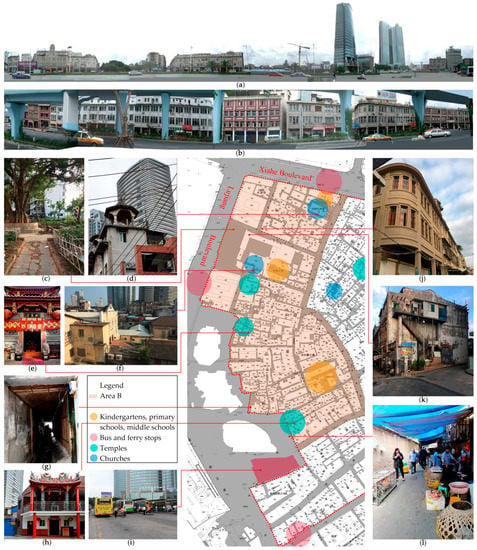
Figure 14.
The fragmented, interrupted, and incoherent urban landscape along the boundaries of Area B: (a) the street view along Lujiang Boulevard with invasive skyscrapers; (b) the street view along Xiahe Boulevard with the inconsistent overpass; (c) an abandoned public space; (d) Zhushu Chapel and its surrounding landscape; (e) Zhaohui Temple; (f) Catholic church and its surrounding landscape; (g) a narrow and dark passage supported by a temporary structure; (h) Fushou Temple; (i) bus stop; (j) the newly-built pseudo building; (k) poor-quality and decaying buildings; and (l) the poultry market occupying the street. Sources: (a) and (b) from School of Architecture, Huaqiao University [74]; (d) from Sina Blog [88]; (e) and (h) from Tencent Fujian [89]; (f) from Zhu [90] (p. 94); (g) and (l) from Sina Blog [91].
5.2.3. Area C: Street Food Thematic Park
Dating back to last decades of the 18th century, this area is always a flourishing business district because of its ideal location—close to the historic and/or present bus stops, wharf, postal office, customs, and concessions. Compared with Areas A and B, Area C has a more regular and clear structure of streets and lanes, and many higher-quality buildings with the dominated intervention approaches of building restoration and conservation (Figure 11). Its clear urban fabric could be attributed to the large-scale reconstruction of the street network from the 1910s to the 1930s. Area C’s advantageous location, particularly its accessibility to the local iconic commercial and tourist areas (Zhongshan Road pedestrian commercial area and Gulangyu Island, Figure 4), attracts many tourists. Lured by tourism interests, Area C gradually became a tourist thematic park of street food with a growing number of restaurants and street food services. Most of them provide expensive and featureless catering services for tourists and are operated by temporary populations from other provinces in China rather than local inhabitants. To a large extent, the history and culture of local cuisine and food, together with associated living styles, are barely represented here, which results in both the lack of a sustainable attraction for tourists and the trend toward more short-term and lower-level tourism. Also, with the lack of effective management, pedestrians, vehicles, movable street food services (specifically in the evening), and advertising boards coexist in the main street (Renhe Road) together with noisy peddlers. The tourist-oriented development resulted in the displacement of local inhabitants by a temporary low-income population who work in tourism. These immigrants completed many haphazard and incoherent additions and renovations, such as adding some temporary service units on balconies and terraces, as well as renovating building facades to create chic Western or Chinese styles through some uncharacteristic architectural elements and bright and disharmonious colored plaster (Figure 15). As a result, the neighborhood’s charming atmosphere and sense of belonging were gradually undermined, with a concomitant decrease in livability.
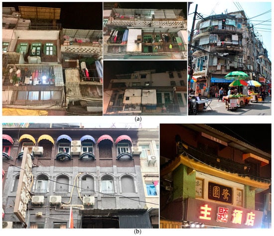
Figure 15.
Area C: (a) the haphazard and incoherent additions for expanding service units; (b) thoughtless and incoherent renovations used to create Western or Chinese styles.
Therefore, the relationship between tourism and local livability should be carefully reconsidered to ensure sustainable development. The present types of business, which are dominated by dynamic and inauthentic food services mostly geared toward tourists, should be enriched. Possible treatments include the introduction of more business types related to the distinguishable identity of local history, traditional culture, and living, and especially some static commercial types, such as teahouses, handicraft shops, and bookshops. Noticeably, the south area of Fujian Province, where the city of Xiamen is situated, is renowned for tea production and culture. Drinking tea plays a vital role on daily life of local inhabitants. The careful consideration and management of the types, proportion, and location of touristic business are needed. To address the crowded streets, the regulation of roadside business behaviors is required. The creation of a pedestrian zone and more underground parking spaces here and nearby may be another solution, which calls for a careful formulation of a new mobility plan for the whole quarter and its surrounding environment. Finally, and more importantly, is the need to manage the many haphazard, thoughtless, and incoherent additions and renovations. A possible solution may be to formulate a comprehensive guideline and a detailed handbook for managing intervention actions, particularly through the control of morphological elements, such as the scale and area, colors, materials, styles, and details, as in the case of Schio (Figure 3).
5.2.4. Area D: The Renovated Cultural and Street Food Square
Located on flatland, Area D centers on the renovated Old Theater Cultural Park (Figure 8). The Old Theater first opened in 1942. Many locally well-known small restaurants operate here since the beginning of the 20th century. From the author’s interviews of project participants and local inhabitants, a series of renovation projects of and around the park (Figure 16), as illustrated above, were well-received and appreciated. In addition to the aforementioned significance, these projects not only produce new and pleasing appearances and pleasant interior spaces in buildings, but they also provide the high-quality public open space for both local inhabitants and visitors to enjoy leisure time within this highly dense neighborhood while getting to know local history and culture. However, more critical voices on present treatments are still largely unheard from both professionals and the public. For instance, some added morphological elements seem to be hardly associated with former buildings and sites. Sometimes, some elements were picked up from other historic buildings. Taking the renovated house located in Dajing Lane No. 3–5 as an example (Figure 16i), its newly added arcade referenced the facade of the historic post office building situated in Area B rather than retracing its own historical evolution [92]. This method of re-interpretation of styles, elements, materials, and colors is not convincing and appropriate, which, to some extent, created in-style false buildings and undermined the local historic urban landscape. A Schio-type handbook may be useful for providing precise criteria and guidelines on managing and controlling the variation in morphological elements.
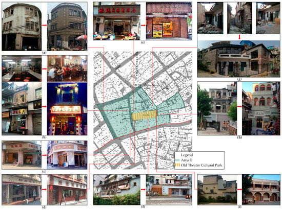
Figure 16.
Area D: buildings before and after renovation: (a) Huangshengji Dried Meat Floss Shop; (b) Taro Bun King Restaurant; (c) Xinji Teahouse; (d) Laicuocheng Dumpling Restaurant; (e) Tong’an Bouilli Pork Restaurant; (f) the Old Theater Coffee; (g) the Gallery of Antique Furniture; (h) the Art Gallery of Yile Paper Cuttings; (i) Dajingjiao Alley No. 3–5. Source: photos (a–i) from Lin [92] (p. 44,50,57,60,81–86).
5.2.5. Area E: Irregular Foothill Settlement
Dominated by a residential function, Area E is a more closed and quieter area with a larger number of modern buildings. The general quality of buildings is better (Figure 10d). The dominant intervention approach here is temporary remaining (Figure 11). Located on a foothill, Area E has the most complex topographic situation, and a labyrinthine, spontaneous, and irregular urban fabric with the changing width of streets and lanes (from 1 to 4 m) (Figure 5). This produces a specific urban landscape and diversified spatial experience, in addition to the apparent inconvenience for daily life, especially regarding the demands of firefighting and ambulances and the increasing aging population. Another important issue for this area that decreased the livability and attractiveness of the whole quarter of Yingping is the growing number of sex workers and so-called “massage shops” that provide illicit sex services. To address these challenges, the careful formulation of definitive criteria and specific proposals to improve accessibility, particularly by considering the needs and distribution of the elderly, should be regarded as a priority. The illegal sex services should be displaced, and strict and effective legal supervision and management should be implemented. The displacement may involve the introduction of other services related to daily life, recreation, and leisure activities, such as grocery shops, street food bars, teahouses, etc.
5.2.6. Area F: Living and Chaotic Market
Dominated by the intervention approach of building re-composition (Figure 11), this area has a large group of poor-quality buildings with many haphazard and incoherent additions and renovations. Compared with other areas, Area F has a more clear and regular urban fabric due to the reconstruction of the street networks in the 1930s. Its history can be dated back to the Ming Dynasty (1368–1644) when the army was stationed here. Since the 18th century, this area is the site of a prosperous market, particularly for fresh seafood. The market includes a formal one covering the whole Guying Road and Yingping Road by fixed steel frames, and an informal one referring to long-term roadside businesses, with temporary canopies occupying Kaihe Road (Figure 17). Consequently, the width of Kaihe Road for passengers and vehicles is only about 3.5 m. Due to noise, smell, and poor sanitary conditions, passengers mostly avoid Guying and Yingping Roads. Located along these streets, the historic arcades are fully filled by boxes and buckets. This, together with the haphazard and thoughtless additions and inappropriate use of public spaces, largely undermined the local arcade landscape. Therefore, the issue of how to better manage the formal and informal markets is a key challenge for this area. This situation suggests the need for a comprehensive and detailed “zoning” plan of market activities, together with effective control and management, across the whole quarter of Yingping, which may involve business types, forms (formal or informal), location, scales, duration, etc. This could be accompanied by careful plans for mobility and arcade urban landscape with an improved and dynamic but powerful system for supervising the uses of public spaces (particularly the roadside business) and the uses of arcade buildings. Additionally, technical and financial support is necessary for mobilizing the rearrangement of stores’ exterior and interior spaces and sanitary conditions.
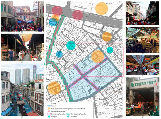
Figure 17.
The lively and chaotic market activities in Area F: (a) the entrance of Kaihe Road with roadside business; (b–d) the informal market on Kaihe Road; (e–g) the formal market. Sources: (a), (d), and (f) from Sina Blog [88]; (e) from XMTV [93].
6. Discussion and Conclusions
Learning from the Italian typology- and morphology-led planning techniques and Banham’s ecological interpretation, this study defines a two-pronged planning framework consisting of five intervention groups and six characterized areas, and corresponding problems and targeted strategies for Yingping. The identification of five intervention groups is particularly inspired by the approach of grouping intervention categories from a maintenance-oriented perspective shown in the plan of Schio. Among the five groups, the analysis and discussion of arcade buildings and landscape was inspired by the Italian typology-led planning technique. The recognition of six characterized areas imitates the method of identifying recognizable parts—particularly shown in the Italian morphology-led planning practices (see plans of Urbino and Caltagirone), and some recent plans through ecological lens. Admittedly, many Italian cases are old and have different backgrounds and contexts from the Chinese case. Yet, the case itself is not important; the technical mechanisms of the plans and planning devices involved, particularly the syntax of technical forms, are the key.
Through identifying the recognizable parts of an urban landscape within interconnected, heterogeneous, and stratified urban fabrics and environment, the Italian morphology-led planning technique aims to maintain and conserve the historic urban environment. This technique focuses on the aggregation of building groups and the integral urban landscape on a larger scale. If necessary, careful partial displacement with (almost) the same materials, technologies, and elements is allowable. To a greater extent, this technique provides a more feasible and effective method to address the current heritage problems of China. Neither the restoration of single buildings nor the typology-led planning technique based on in-depth study of building types currently works well in the Chinese context due to the associated tremendous time and financial cost, the pressure from real-estate development, the urgent need for urban redevelopment, the lack of public awareness of urban conservation, and the overall heterogeneous and layered urban fabrics and structures. Essentially, heritage problems in China are more related to urbanscape, environment, and parts of the city rather than single buildings. Also, the focus on integrated urban fabrics and landscape and the allowance of partial substitution seem much closer to the specific conservation ethics, teleology, and axiology in China, i.e., the stronger interest in immaterial elements and the long-term under-appreciation of tangible heritage, which resulted in the cultural differences between China and the West (for instance, Italy) in terms of the treatment of the urban historic environment.
Rather than previous development projects, the recent destruction of the historic urban environment in China was largely induced by “conservation” projects, especially pseudo-historic “conservation” projects. The main culprit could be the lack of a unified consensus and standard on understanding and practicing what should be conserved, and why and how. In response, the Italian morphology-led planning technique, from a technical perspective, provides the ability to address (1) the “what”—the integral urban fabric and urban landscape rather than single monuments or specific architectural types and styles as the present Chinese way does, and (2) the “how”—through identifying, interpreting, and managing recognizable parts. This technique also provides metaphysical inspiration to address the “why”, since practices dominated by the technique indicate that the maintenance of physical consistency not only enables the improvement of living quality, “biodiversity”, and social cohesion for the common people (not only for tourists) [9,94], but also produce a practical advantage as an asset to manage urban change and facilitate sustainable development through recognizing and reconnecting various structured urban areas with their specific connotative features [95,96]. In other words, heritage could be deemed as an engine driving the sustainable development of both historic environments and the entire urban territory, which is also reflected on the concept of historic urban landscape proposed by the United Nations Educational, Scientific and Cultural Organization (UNESCO) in 2011 [24,97].
Following the case study of Gulangyu Island, Xiamen [15], this research has some marked similarities with the former. For instance, as initial studies, both present the possibility that such techniques have the applicability to the Chinese context for improving the present methods of addressing the planning and heritage problems [15]. Both studies attempt to analyze and de-structure the complicated and heterogeneous physical and social situation of the quarters into some homogeneous featured areas for deeply discussing the corresponding crucial problems and further developing and coordinating a specific framework of targeted treatment rules and strategies to suggest possible improvements in future. Yet, they also have some significant differences. The study of Gulangyu (an island located off the coast of Yingping with a typical colonial urban landscape) focuses more on how to address the problems resulting from the existing municipal tourist-oriented plans and policies, and particularly the imbalance between developing tourism and improving livability. In contrast, the case of Yingping, with an indeterminate large-scale planning scheme, faces a more complicated, heterogeneous, and stratified urban fabric and landscape. The study of Yingping, from a more maintenance-oriented perspective, aims at providing a strategic thematization of optimizing planning strategies and suitable guidelines to direct future governmental actions and support the self-maintenance of local inhabitants. The six areas identified in Yingping are more strategic and similar to five strategic places devised in the Structural Plan of Antwerp, where a thematic frame of planning policies and strategies for five strategic places were shaped with indicated high-priority actions [81].
However, more research is still required to further explore the feasibility and implications of Italian typology- and morphology-led planning techniques in China, such as in traditional (feudal) historic quarters, historic towns and villages, and urban sprawl and shrinking territories. For Yingping, conducting more interviews and field surveys about the intentions of local government, professionals, and inhabitants would provide useful but perhaps more critical reconsideration of the study, for instance, about the relationship between possible costs and set objectives [98]. Completing a more in-depth study of the planning framework and strategies proposed by this research appears necessary, for instance, taking into account of the relationship between the five intervention groups and the six characterized areas, and the various strategies and guidelines involved and their priority. Some social issues, such as the complex and indistinct property rights, need specific attention. A more comprehensive and holistic consideration of relationship between Yingping and its surrounding area is suggested, which may include a new mobility plan, some detailed “zoning” plans of arcade buildings and landscape, and various market activities, and controlling and managing the amount and behaviors of temporary population. Such consideration may be further explored at the municipal scale through the ecological lens as completed in the plans of Antwerp and Bologna to facilitate the maintenance of the physical consistency and sustainable development of the whole contemporary city.
Urban planning patterns in China shifted from expansion-oriented urban development toward the redevelopment of already developed urban territory. In terms of the vital historic neighborhoods with an indeterminate large-scale planning scheme like Yingping, this study presents a planning alternative—the dynamic maintenance of the whole urban fabric and landscape rather than the traditional approach—displaced by large-scale urban redevelopment projects or creating pseudo-historical touristic districts. Policy supports from governments for retaining original inhabitants and their life-styles, as well as facilitating their self-maintenance actions, are needed. Financially, policies may include the direct funding supports, for instance, paying some parts of maintenance and renovation fees, and the indirect, such as tax credits and incentives. Technically, policies may include the invitation of relevant professionals to participate in the survey, design, construction, maintenance, and evaluation of buildings and built environment, for example, establishing the system of community planners that was recently developed in Shanghai [99,100]. These policies could be accompanied by developing publicity and education programs about the significances of maintaining local historic urban landscape, and proper planning guidelines and a Schio-type detailed handbook for guiding self-maintenance actions. Incorporating public participation and the ideas of “zoning” into integrated conservation and planning policy is advocated. From a long-term perspective, policy guidance and institutional supports for the growth of citizenship, and weakening the roles of developers and the local government are indispensable, aiming to motivate a more effective bottom-up approach. This is crucial for China, particularly as this country’s dominant top-down political system marginalized the participation of not only relevant professional and non-government organizations (NGOs), but also the local residents in heritage conservation initiatives. The present challenges confronting Yingping also exist in other countries around the world, especially in many developing countries. This study is expected to inspire further exploration of such techniques in other contexts as a means of addressing the challenge of conserving urban heritage and improving local livability, and further providing impetus to future sustainable development.
Funding
This research received no external funding.
Conflicts of Interest
The author declares no conflict of interest.
References
- Kupka, K. Redevelopment by Tradition. Urban Renewal in World Heritage Cities. The effects of Plans and Projects in Amsterdam, Florence, Genoa and Venice; Libreria Cluva Editrice: Venice, Italy, 2012; p. 10. [Google Scholar]
- Albrecht, B. Exporting the urban core. In Exporting the Urban Core; Albrecht, B., Magrin, A., Eds.; Rubettino: Soveria Mannelli, Italy, 2015; pp. 21–25. [Google Scholar]
- Bandarin, F. Appunti per un’analisi del contributo italiano alla conservazione del patrimonio urbano. In Esportare il Centro Storico; Albrecht, B., Magrin, A., Eds.; Rubbettino: Soveria Mannelli, Italy, 2015; pp. 32–41. [Google Scholar]
- Balducci, A.; Gaeta, L. (Eds.) L’urbanistica italiana nel mondo. Contributi e debiti culturali; Donzelli: Rome, Italy, 2015. [Google Scholar]
- Bonfantini, G.B. Planning the historic centres in Italy: For a critical outline. Planum 2012, 25, 1–19. Available online: http://www.planum.net/planning-the-historic-centres-in-italy (accessed on 10 January 2019).
- Gabellini, P. Culture for the city’s future. In Exporting the Urban Core; Albrecht, B., Magrin, A., Eds.; Rubbettino: Soveria Mannelli, Italy, 2015; pp. 56–59. [Google Scholar]
- Bandarin, F. Urban conservation in Italy and across the world: New challenges for urban heritage 50 years after the Venice Charter. In Exporting the Urban Core; Albrecht, B., Magrin, A., Eds.; Rubettino: Soveria Mannelli, Italy, 2015; pp. 64–73. [Google Scholar]
- Scattoni, P.; Falco, E. Why Italian Planning is worth studying. Ital. J. Plan. Pract. 2011, 1, 4–32. [Google Scholar]
- Lazzarotti, R. Historical centres: Changing definitions. Ital. J. Plan. Pract. 2011, 1, 73–89. [Google Scholar]
- Gabellini, P. Profiles of Italian urban planning. Planum 2008, 1–15. Available online: http://www.planum.net/download/profiles-of-italian-urban-planning (accessed on 10 January 2019).
- Ceccarelli, P. Giochi di sponda. In L’urbanistica italiana nel mondo. Contributi e debiti culturali; Balducci, A., Gaeta, L., Eds.; Donzelli: Rome, Italy, 2015; pp. 97–104. [Google Scholar]
- Bonfantini, G.B. Progetto Urbanistico e Città Esistente: Gli Strumenti Discreti Della Regolazione; Libreria Clup: Milan, Italy, 2002. [Google Scholar]
- Bandarin, F. Introduction: Urban conservation and the end of planning. In Reconnecting the City. The Historic Urban Landscape Approach and the Future of Urban Heritage; Bandarin, F., van Oers, R., Eds.; Wiley-Blackwell: Chichester, UK, 2015; pp. 1–16. [Google Scholar]
- Gasparrini, C. L’attualità dell’urbanistica: Dal piano al progetto, dal progetto al piano; Etas libri: Milan, Italy, 1994; pp. 164–183. [Google Scholar]
- Xie, S.; Zhang, X.; Li, Y.; Skitmore, M. Echoes of Italian lessons on the typo-morphological approach: A planning proposal for Gulangyu Island, China. Habitat Int. 2017, 69, 1–17. [Google Scholar] [CrossRef]
- Whitehand, J.; Gu, K. Urban conservation in China: Historical development, current practice and morphological approach. Town Plan. Rev. 2007, 78, 643–670. [Google Scholar] [CrossRef]
- Qian, Z. Historic district conservation in China: Assessment and prospects. Trad. Dwel. Settl. Rev. 2007, 19, 59–76. [Google Scholar] [CrossRef]
- Ye, L. Urban regeneration in China: Policy, development, and issues. Local Econ. 2011, 26, 337–347. [Google Scholar] [CrossRef]
- Agnew, N.; Demas, M.; Sullivan, S.; Altenburg, K. The begetting of charters: Genesis of the China Principles. Hist. Environ. 2004, 18, 40–45. [Google Scholar]
- Qian, F. China’s Burra Charter: The Formation and Implementation of the China Principles. Int. J. Herit. Stud. 2007, 13, 255–264. [Google Scholar] [CrossRef]
- Chen, S. The Concept of Historic Authenticity and Its Methdology for Preservation of Historic Urban Areas in Chinese Contexts. Chang. Over Time 2014, 4, 404–417. [Google Scholar] [CrossRef]
- Zhu, Y. Cultural Effects Cultural Effects of Authenticity: Contested Heritage Practices in China. Int. J. Herit. Stud. 2015, 4, 594–608. [Google Scholar] [CrossRef]
- Su, X. Reconstructing Tradition: Heritage Authentication and Tourism-Related Commodification of the Ancient City of Pingyao. Sustanability 2018, 10, 670. [Google Scholar] [CrossRef]
- González Martínez, P. Authenticity as a challenge in the transformation of Beijing’s urban heritage: The commercial gentrification of the Guozijian historic area. Cities 2016, 59, 48–56. [Google Scholar] [CrossRef]
- González Martínez, P. Urban authenticity at stake: A new framework for its definition from the perspective of heritage at the Shanghai Music Valley. Cities 2017, 70, 55–64. [Google Scholar] [CrossRef]
- van Oers, R.; Pereira Roders, A. Road map for application of the HUL approach in China. J. Cult. Herit. Manag. Sustain. Dev. 2013, 3, 4–17. [Google Scholar] [CrossRef]
- Shin, H.B. Urban conservation and revalorisation of dilapidated historic quarters: The case of Nanluoguxiang in Beijing. Cities 2010, 27, 43–54. [Google Scholar] [CrossRef]
- Su, X. Heritage Production and Urban Locational Policy in Lijiang, China. Int. J. Urban Reg. Res. 2011, 35, 1118–1132. [Google Scholar] [CrossRef]
- Su, X. Urban entrepreneurialism and the commodification of heritage in China. Urban Stud. 2014, 52, 2874–2889. [Google Scholar] [CrossRef]
- Zhu, Y. Uses of the past: Negotiating heritage in Xi’an. Int. J. Herit. Stud. 2017, 24, 181–192. [Google Scholar] [CrossRef]
- Zinda, J.A. Tourism dynamos: Selective commodification and developmental conservation in China’s protected areas. Geoforum 2017, 78, 141–152. [Google Scholar] [CrossRef]
- He, S.; Wu, F. Property-Led Redevelopment in Post-Reform China: A Case Study of Xintiandi Redevelopment Project in Shanghai. J. Urban Aff. 2005, 27, 1–23. [Google Scholar] [CrossRef]
- Yang, Y.-R.; Chang, C.-H. An Urban Regeneration Regime in China: A Case Study of Urban Redevelopment in Shanghai’s Taipingqiao Area. Urban Stud. 2016, 44, 1809–1826. [Google Scholar] [CrossRef]
- Wang, Y.; Bramwell, B. Heritage protection and tourism development priorities in Hangzhou, China: A political economy and governance perspective. Tour. Manag. 2012, 33, 988–998. [Google Scholar] [CrossRef]
- Zhang, R. World Heritage listing and changes of political values: A case study in West Lake Cultural Landscape in Hongzhou, China. Int. J. Herit. Stud. 2016, 23, 215–233. [Google Scholar] [CrossRef]
- Zhai, B.; Ng, M.K. Urban regeneration and social capital in China: A case study of the Drum Tower Muslim District in Xi’an. Cities 2013, 35, 14–25. [Google Scholar] [CrossRef]
- Fan, L. International influence and local response: Understanding community involvement in urban heritage conservation in China. Int. J. Herit. Stud. 2013, 20, 651–662. [Google Scholar] [CrossRef]
- Verdini, G. Is the incipient Chinese civil society playing a role in regenerating historic urban areas? Evidence from Nanjing, Suzhou and Shanghai. Habitat Int. 2015, 50, 366–372. [Google Scholar] [CrossRef]
- Han, F.; Yang, Z.; Shi, H.; Liu, Q.; Wall, G. How to Promote Sustainable Relationships between Heritage Conservation and Community, Based on a Survey. Sustainability 2016, 8, 886. [Google Scholar] [CrossRef]
- Tan, X.; Altrock, U. Struggling for an adaptive strategy? Discourse analysis of urban regeneration processes—A case study of Enning Road in Guangzhou City. Habitat Int. 2016, 56, 245–257. [Google Scholar] [CrossRef]
- Qian, Z.; Li, H. Urban morphology and local citizens in China’s historic neighborhoods: A case study of the Stele Forest Neighborhood in Xi’an. Cities 2017, 71, 97–109. [Google Scholar] [CrossRef]
- Nomura, R.; Shan, S.; Mori, S. Analyzing Spatial Structure of Traditional Houses in Old Towns with Tourism Development and Its Transformation toward Sustainable Development of Residential Environments in Hexia Old Town, in China. Sustainability 2018, 10, 3809. [Google Scholar] [CrossRef]
- Ren, W.; Han, F. Indicators for Assessing the Sustainability of Built Heritage Attractions: An Anglo-Chinese Study. Sustainability 2018, 10, 2504. [Google Scholar] [CrossRef]
- Kou, H.; Zhou, J.; Chen, J.; Zhang, S. Conservation for Sustainable Development: The Sustainability Evaluation of the Xijie Historic District, Dujiangyan City, China. Sustainability 2018, 10, 4645. [Google Scholar] [CrossRef]
- Zhang, L.; Chen, J.; Tochen, R.M. Shifts in governance modes in urban redevelopment: A case study of Beijing’s Jiuxianqiao Area. Cities 2016, 53, 61–69. [Google Scholar] [CrossRef]
- D’Agostino, R. Tianjin 2004-2005: Il progetto urbanistico. In Esportare il Centro Storico; Albrecht, B., Magrin, A., Eds.; Rubbettino: Soveria Mannelli, Italy, 2015; pp. 412–413. [Google Scholar]
- Fontanari, E. La salvaguardia dei centri storici in America Latina: Un paradigm italiano. In Esportare il Centro Storico; Albrecht, B., Magrin, A., Eds.; Rubettino: Soveria Mannelli, Italy, 2015; pp. 76–85. [Google Scholar]
- Pola, A.P. L’America Latina, dal restauro urbano alla tutela integrata della citta storica. In Esportare il Centro Storico; Albrecht, B., Magrin, A., Eds.; Rubettino: Soveria Mannelli, Italy, 2015; pp. 302–311. [Google Scholar]
- Albrecht, B.; Magrin, A. (Eds.) Exporting the Urban Core; Rubettino: Soveria Mannelli, Italy, 2015. [Google Scholar]
- Bandarin, F. The Bologna experience: Planning and historic renovation in a communist city. In The Conservation of European Cities; Appleyard, D., Ed.; The MIT Press: Cambridge, MA, USA, 1979; pp. 178–202. [Google Scholar]
- D’Acci, L. On Urban Morphology and Mathematics. In The Mathematics of Urban Morphology; D’Acci, L., Ed.; Springer Nature: Basel, Switzerland, 2019; pp. 1–12. [Google Scholar]
- Cataldi, G.; Maffei, G.L.; Vaccaro, P. Saverio Muratori and the Italian school of planning typology. Urban Morphol. 2002, 6, 3–14. [Google Scholar]
- Cataldi, G. From Muratori to Caniggia: The origins and development of the Italian school of design typology. Urban Morphol. 2003, 7, 19–34. [Google Scholar]
- Muratori, S. Studi per una operante storia urbana di Venezia; Istituto Poligrafico dello Stato: Rome, Italy, 1960. [Google Scholar]
- Muratori, S. Studi per una operante storia urbana di Rome; Centro Studi di Storia Urbanistica: Rome, Italy, 1963. [Google Scholar]
- Caniggia, G. Lettura di una città: Como; Centro Studi di Storia Urbanistica: Rome, Italy, 1963. [Google Scholar]
- Gu, K.; Tian, Y.; Whitehand, J.W.R.; Whitehand, S.M. Residential building types as an evolutionary process: The Guangzhou area, China. Urban Morphol. 2008, 12, 97–115. [Google Scholar]
- Chen, F.; Romice, O. Preserving the cultural identity of Chinese cities in urban design through a typomorphological approach. Urban Des. Int. 2009, 14, 36–54. [Google Scholar] [CrossRef]
- Chen, F. Traditional architectural forms in market oriented Chinese cities: Place for localities or symbol of culture? Habitat Int. 2011, 35, 410–418. [Google Scholar] [CrossRef]
- Li, Y.; Gauthier, P. The evolution of residential buildings and urban tissues in Guangzhou, China: Morphological and typological perspectives. Urban Morphol. 2014, 18, 129–149. [Google Scholar]
- Lynch, K. The Image of the City; The MIT Press: Cambridge, MA, USA, 1960. [Google Scholar]
- Debord, G. Théorie de la dérive. Int. Situat. 1958, 2, 19–23. [Google Scholar]
- Sadler, S. The Situationist City; The MIT Press: Cambridge, MA, USA, 1999. [Google Scholar]
- Stan, A. Morphological patterns of urban sprawl territories. Urban. Arhit. Constr. 2013, 4, 11–24. [Google Scholar]
- Psenner, A.; Kodydek, K. Researching the morphology of the city’s internal micro structure: UPM Urban Parterre Modelling. In City and territory in the Globalization Age, Proceedings of the 24th ISUF International Conference, Valencia, Spain, 27–29 September 2017; Editorial Universitat Politècnica de València: Valencia, Spain, 2018; pp. 1245–1254. [Google Scholar] [CrossRef]
- Psenner, A.; Kodydek, K. Urban Parterre Modeling UPM: Lifting the Cadastral Map to the Third Dimension. In Are “Smart Cities” the Solution or Part of the Problem of Continuous Urbanisation around the Globe? Proceedings of the 23rd International Conference on Urban Planning, Regional Development and Information Society, Vienna, Austria, 4–6 April 2018; Schrenk, M., Popovich, V.V., Zeile, P., Elisei, P., Beyer, C., Navratil, G., Eds.; CORPE–Competence Center of Urban and Regional Planning: Vienna, Austria, 2018; pp. 735–743. [Google Scholar]
- Lanzani, A. I Paesaggi Italiani; Meltemi: Rome, Italy, 2003; p. 83. [Google Scholar]
- Fontana, C. Recuperare: Le parole e le cose: Metodi progettuali ed esiti pratici dell’intervento sull’edificato esistente in Italia; Alinea Editrice: Florence, Italy, 1991; p. 34. [Google Scholar]
- Cervellati, P.L.; Scannavini, R. Bologna: Politica e metodologia del restauro nei centri storici; Il Mulino: Bologna, Italy, 1973. [Google Scholar]
- Astengo, G. Assisi: Piano generale e piani particolareggiati di primo intervento. Urbanistica 1965, 24–25, 10–124. [Google Scholar]
- De Carlo, G. Urbino. La storia di una città e il piano della sua evoluzione urbanistica; Marsilio: Padova, Italy, 1966. [Google Scholar]
- Leone, N.G.; Iacona, G.; Merlo, V.; Quartarone, C. Il disegno e la regola: Recupero e Piano Quadro del Centro Storico di Caltagirone; Flaccovio: Palermo, Italy, 1988. [Google Scholar]
- Mancuso, F. Un manuale per “Nuova Schio”: Piano particolareggiato per la riqualificazione urbanistica ed ambientale del quartiere operaio “Alessandro Rossi”; Arsenale: Venice, Italy, 1990. [Google Scholar]
- School of Architecutre, Huaqiao University. Design of Yingping Area of Xiamen, Unpublished Report. 2013.
- Archiposition. Available online: http://archiposition.com/travel/inspirations/item/1342-xiamen-architecture.html (accessed on 18 January, 2019).
- Taihainet. Available online: http://www.taihainet.com/news/xmnews/shms/2016-03-15/1697897.html (accessed on 18 January 2019). (In Chinese).
- Banham, R. Los Angeles: The Architecture of Four Ecologies; Univ. of California Press: Berkeley, CA, USA, 2001. [Google Scholar]
- Vilder, A. Introduction: Los Angeles: City of the immediate future. In Los Angeles: The Architecture of Four Ecologies; Banham, R., Ed.; Univ. of California Press: Berkeley, CA, USA, 2001; pp. xvii–xxxiii. [Google Scholar]
- Viganò, P. Recent plans and projects of studio 1998: Description. Urbanistica 1998, 111, 77–88. [Google Scholar]
- Di Paola, A.; Di Paola, F. Fondamenti di urbanistica. Conservazione e città; Aracne editrice: Canterano, Italy, 2018; pp. 370–388. [Google Scholar]
- Viganò, P.; Secchi, B. Antwerp, Territory of a New Modernity; Sun Publishers: Amsterdam, The Netherlands, 2009. [Google Scholar]
- Comune di Bologna. Bologna: Leggere il Nuovo Piano Urbanistico: PSC + RUE + POC; Edisai: Ferrara, Italy, 2009. [Google Scholar]
- Cigalotto, P. Ambiente e paesaggio: Una nuova struttura di piano per una diversa cultura del progetto. Urbanistica 2015, 156, 78–79. [Google Scholar]
- Mazza, L. Plan and constitution—Aristotle’s Hippodamus: Towards an ‘ostensive’ definition of spatial planning. Town Plan. Rev. 2009, 80, 113–141. [Google Scholar] [CrossRef]
- Chang, T.C. ‘New uses need old buildings’: Gentrification aesthetics and the arts in Singapore. Urban Stud. 2014, 53, 524–539. [Google Scholar] [CrossRef]
- Yung, E.H.K.; Langston, C.; Chan, E.H.W. Adaptive reuse of traditional Chinese shophouses in government-led urban renewal projects in Hong Kong. Cities 2014, 39, 87–98. [Google Scholar] [CrossRef]
- Urbaneer. The Preliminary Planning Study of the Renovation of Yingping, Xiamen, Unpublished report. 2013.
- Sina Blog. Available online: http://blog.sina.com.cn/s/blog_74a24f0f0101638j.html (accessed on 18 January 2019).
- Tecent Fujian. Available online: http://myfj.qq.com/t-264496-1.htm (accessed on 18 January 2019).
- Zhu, C. The Research of Urban Morphology Evolution Based on the Influnence of Industrial ad Commerical Change—A Case Study in Yingping District of Xiamen. Master’s Thesis, Huaqiao University, Xiamen, China, 2016; p. 94. (In Chinese). [Google Scholar]
- Sina Blog. Available online: http://blog.sina.com.cn/s/blog_74a24f0f0102vg8a.html (accessed on 18 January 2019).
- Lin, J. A Study on Regeneration of Old Cities Based on Community Livelihood and Culture—A Case Study of Xiamen Yingping Area. Master’s Thesis, Huaqiao University, Xiamen, China, 2017; pp. 62–64. (In Chinese). [Google Scholar]
- XMTV. Available online: http://xiamen.xmtv.cn/2015/02/06/ARTI1423154117564123.shtml.http://myfj.qq.com/t-264496-1.htm (accessed on 18 January 2019).
- Di Giovanni, A. Spazi comuni. Progetto urbanistico e vita in pubblico nella città contemporanea; Carocci: Rome, Italy, 2010; p. 173. [Google Scholar]
- Corten, J.-P.; Geurts, E.; Meurs, P.; Vermeulen, R. Heritage as an Asset for Inner-city Development: An Urban Manager’s Guide Book; nai010 Publishers: Rotterdam, The Netherlands, 2014. [Google Scholar]
- Bonfantini, G.B. Historic Urbanscapes For Tomorrow, Two Italian Cases: Genoa and Bologna. Eur. Spat. Res. Policy 2015, 22, 57–71. [Google Scholar] [CrossRef]
- UNESCO. Recommendation on Historic Urban Landscape; UNESCO: Paris, France, 2011. [Google Scholar]
- Bertaud, A. Order without Desgin. How Markets Shape Cities; MIT Press: Cambridge, MA, USA, 2018; pp. 345–346. [Google Scholar]
- The Government of Hongkou District, Shanghai. The Implementation Measures of the Institution of Community Planners in Hongkou District. Available online: http://xxgk.shhk.gov.cn/hkxxgk/Depart/showinfo.aspx?InfoID=58abf70a-1429-4ddc-87ba-2a27c9aa96c5&CategoryNum=002001003001&DeptCode=001001 (accessed on 21 March 2019). (In Chinese)
- Liu, S.; Xu, L. Study on the Community Regeneration Propelled by Community Planners and Its Frame. Shanghai Urban Plan. Rev. 2018, 4, 28–36. (In Chinese) [Google Scholar] [CrossRef]
© 2019 by the author. Licensee MDPI, Basel, Switzerland. This article is an open access article distributed under the terms and conditions of the Creative Commons Attribution (CC BY) license (http://creativecommons.org/licenses/by/4.0/).