The Influence of River Channel Occupation on Urban Inundation and Sedimentation Induced by Floodwater in Mountainous Areas: A Case Study in the Loess Plateau, China


 ,
,  ,
,
Abstract
1. Introduction
2. Study Area and Data
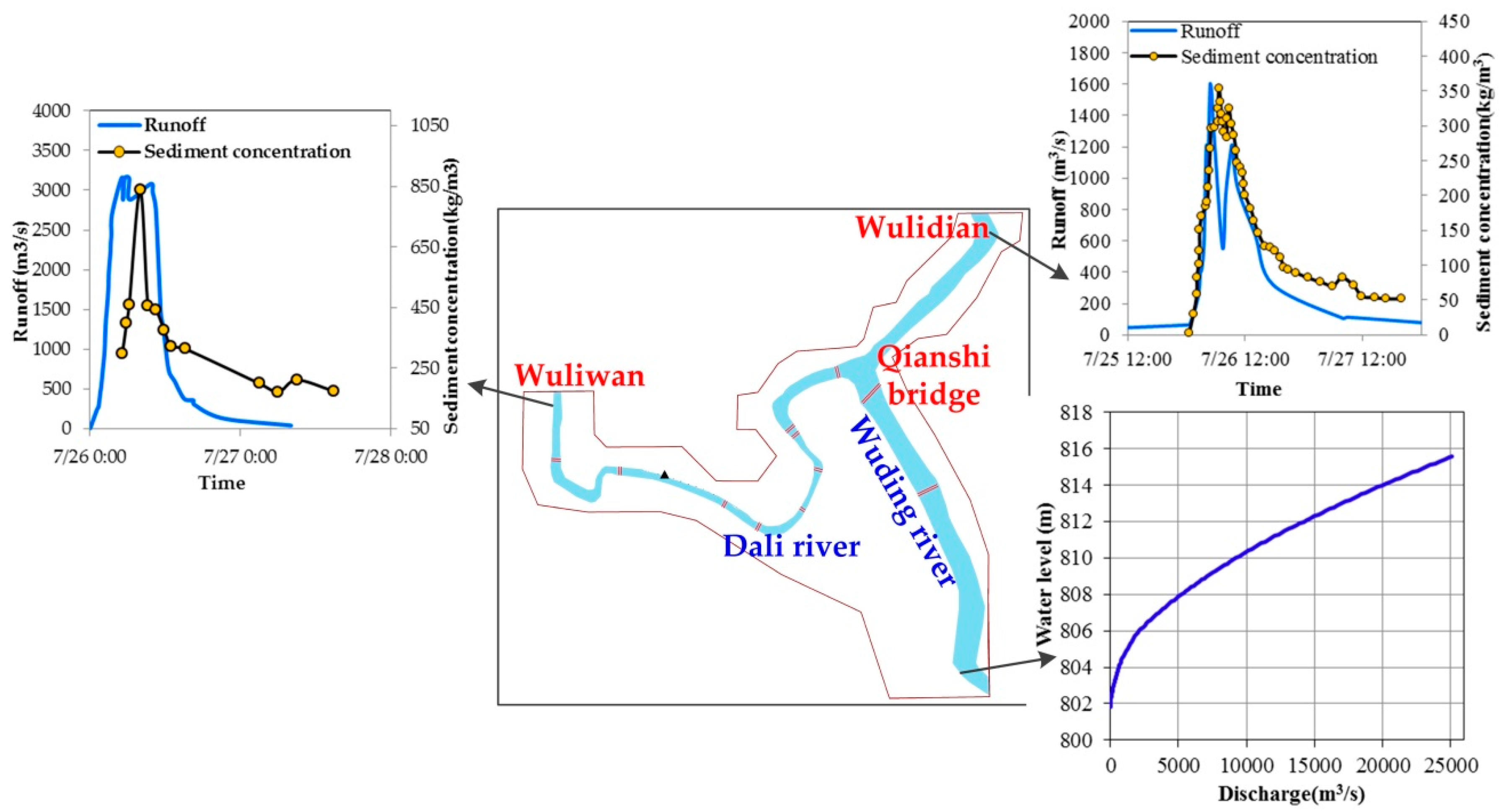
2.1. Study Area
2.2. Satellite Remote Sensing Data
2.3. Field Survey Data
3. Methodology
3.1. River Channel Dynamic Detection Using NDVI Time-Series And High-Resolution Imagery
3.2. Calculation of Urban Inundated Area and Sedimentation Based on Field Survey Data
3.3. Simulation of Urban Inundation and Sedimentation Using the YRCC2D Model
3.3.1. Two-Dimensional Flow and Sediment Hydrodynamic Model
3.3.2. Numerical Simulation Using YRCC2D Model
3.4. Analysis of the Impacts of River Channel Occupations on Urban Flood Disasters
4. Results
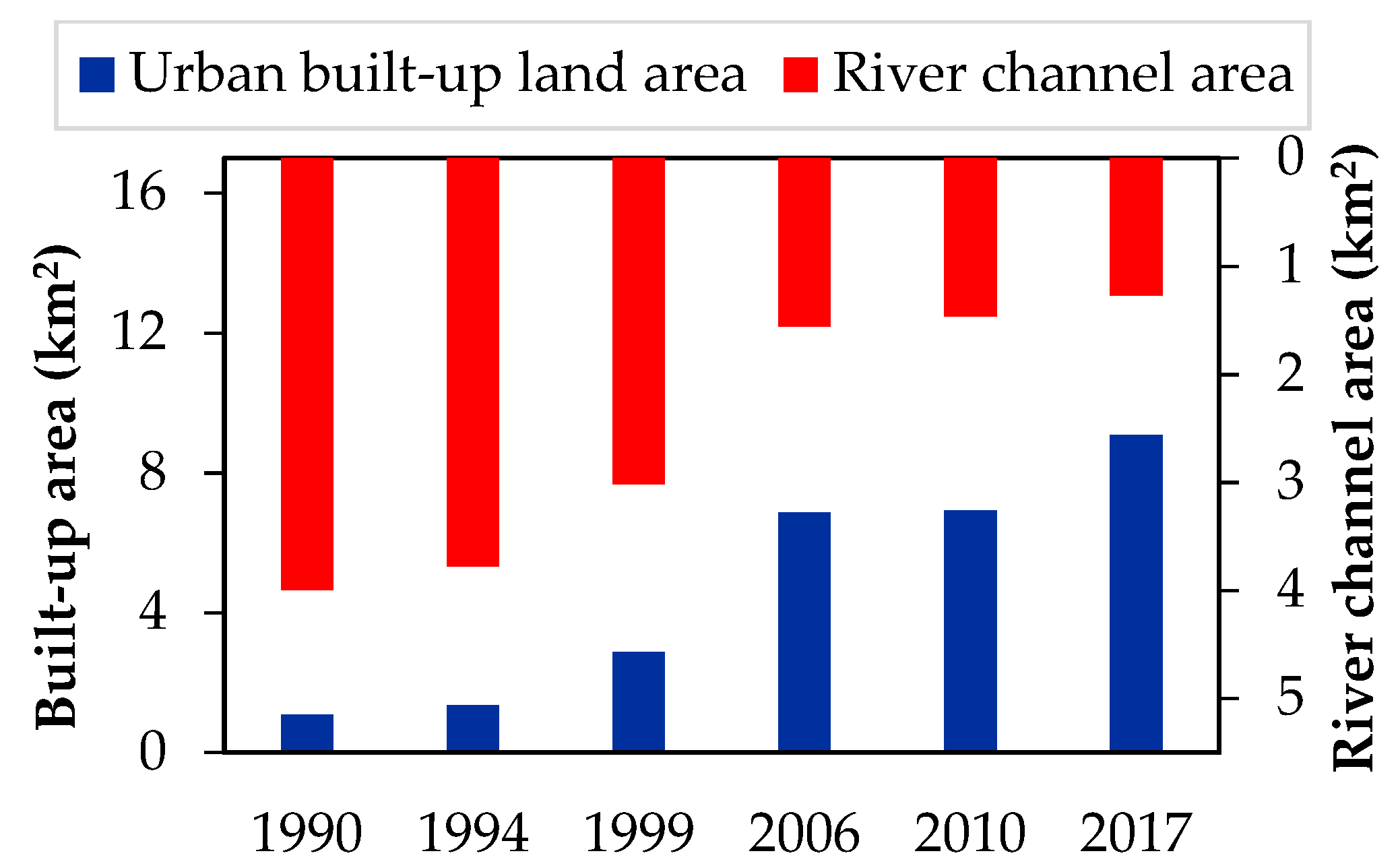
4.1. Dynamics of River Channel Occupation in the Suide County
4.2. Validation of Urban Inundation and Sedimentation Simulated by the YRCC2D Model
4.3. Impacts of River Channel Width and Bridge/House Construction on Urban Inundation and Sedimentation
5. Discussion
5.1. Application of Detection Method for River Channel Occupation
5.2. Influence Mechanism of River Channel Occupation on Urban Flooding Risk
5.3. Uncertainties and Limitations
5.4. Recommdation of Sustainable Flood Mitigation Measures
- Conduct frequent flood analysis according to the characteristics of river hydrology, and investigate the current flood discharge capacity of the river channel and the demand for flood control standards;
- Develop scientific river control routes, and river reconnection with the adjoining floodplain can be used for water storage, which is less expensive than artificial constructions;
- Raise flood control standards on both banks of the river for the occupied river channel in the flood-prone areas;
- Make environmentally-friendly urban construction plans, and adopt natural systems such as the incorporation of soil and vegetation in urban runoff control strategies instead of the traditional rapid-draining approach according to the concept of the ‘sponge city’ proposed by the Chinese government [54];
- Strengthen local administrative supervision by referencing the “river leader” system [57] implemented by the Chinese government, and effectively eliminate irrational constructions in the river terrace or main river channel;
- Increase flood awareness programs in all schools and other relevant institutions [53];
- Develop community capital through flood action groups [58].
6. Conclusions
Author Contributions
Funding
Acknowledgments
Conflicts of Interest
References
- Fan, Y.F. Research on factors influencing an individual’s behavior of energy management: A field study in China. J. Manag. Anal. 2017, 4, 203–239. [Google Scholar] [CrossRef]
- Yang, X.J. China’s rapid urbanization. Science 2013, 342, 310. [Google Scholar] [CrossRef] [PubMed]
- Bai, X.M.; Shi, P.J.; Liu, Y.S. Realizing China’s urban dream. Nature 2014, 509, 158–160. [Google Scholar] [CrossRef] [PubMed]
- Chen, M.; Liu, W.; Tao, X. Evolution and assessment on China’s urbanization1960–2010: Under-urbanization or over-urbanization? Habitat Int. 2013, 38, 25–33. [Google Scholar] [CrossRef]
- Shang, J.; Wang, Z.; Li, L.; Chen, Y.; Li, P.F. A study on the correlation between technology innovation and the new-type urbanization in Shaanxi province. Technol. Forecast. Soc. Chang. 2018, 135, 266–273. [Google Scholar] [CrossRef]
- National Bureau of Statistics of China (NBSC). China Statistical Yearbook; China Statistics Press: Beijing, China, 2013.
- Chen, M.X.; Liu, W.D.; Lu, D.D. Challenges and the way forward in China’s new-type urbanization. Land Use Policy 2016, 55, 334–339. [Google Scholar] [CrossRef]
- Guan, X.L.; Wei, H.K.; Lu, S.S.; Dai, Q.; Su, H.J. Assessment on the urbanization strategy in China: Achievements, challenges and reflections. Habitat Int. 2018, 71, 97–109. [Google Scholar] [CrossRef]
- Cai, J.L.; Yin, H.; Olli, V. Impacts of urbanization on water use and energy-related CO2 emissions of residential consumption in China: A spatio-temporal analysis during 2003–2012. J. Clean. Prod. 2018, 194, 23–33. [Google Scholar] [CrossRef]
- Liu, J.; Shen, Z.Y.; Chen, L. Assessing how spatial variations of land use pattern affect water quality across a typical urbanized watershed in Beijing, China. Landsc. Urban Plan. 2018, 176, 51–63. [Google Scholar] [CrossRef]
- Yu, H.B.; Song, Y.H.; Chang, X.; Gao, H.; Peng, J. A Scheme for a Sustainable Urban Water Environmental System during the Urbanization Process in China. Engineering 2018, 4, 190–193. [Google Scholar] [CrossRef]
- Wu, J.S.; Chen, B.K.; Mao, J.Y.; Feng, Z. Spatiotemporal evolution of carbon sequestration vulnerability and its relationship with urbanization in China’s coastal zone. Sci. Total Environ. 2018, 645, 692–701. [Google Scholar] [CrossRef] [PubMed]
- Adhikari, P.; Hong, Y.; Douglas, K.R.; Kirschbaum, D.B.; Gourley, J.; Adler, R.; Brakenridge, G.R. A digitized global flood inventory (1998–2008): Compilation and preliminary results. Nat. Hazards 2010, 55, 405–422. [Google Scholar] [CrossRef]
- Chen, Y.B.; Zhou, H.L.; Zhang, H.; Du, G.M.; Zhou, J.H. Urban flood risk warning under rapid urbanization. Environ. Res. 2015, 139, 3–10. [Google Scholar] [CrossRef] [PubMed]
- Grove, M.; Harbor, J.M. Impacts of urbanization on surface hydrology, Little Eagle Creek, IN, and analysis of LTHIA model sensitivity to data resolution. Phys. Geogr. 2001, 22, 135–153. [Google Scholar] [CrossRef]
- Cai, Y.P.; Huang, G.H.; Tan, Q.; Chen, B. Identification of optimal strategies for improving eco-resilience to floods in ecologically vulnerable regions of a wetland. Ecol. Model. 2011, 222, 360–369. [Google Scholar] [CrossRef]
- Wang, J.; Wang, H.J.; Hong, Y. A high-resolution flood forecasting and monitoring system for China using satellite remote sensing data. Chin. Sci. Bull. 2016, 61, 518–528. [Google Scholar]
- Zhou, Y.; Liu, Y.S.; Wu, W.X. Disaster risk: Strengthen china’s flood control. Nature 2016, 536, 396. [Google Scholar] [CrossRef] [PubMed]
- Su, M.R.; Zheng, Y.; Hao, Y.; Chen, Q.H.; Chen, S.H.; Chen, Z.Y.; Xie, H. The influence of landscape pattern on the risk of urban water-logging and flood disaster. Ecol. Indic. 2018, 92, 133–140. [Google Scholar] [CrossRef]
- Choi, W.; Nauth, K.; Choi, J.; Becker, S. Urbanization and rainfall–runoff relationships in the Milwaukee River basin. Prof. Geogr. 2016, 68, 14–25. [Google Scholar] [CrossRef]
- Zhang, X.F.; Zhang, X.; Hu, S.; Liu, T.; Li, G.H. Runoff and sediment modeling in a peri-urban artificial landscape: Case study of Olympic Forest Park in Beijing. J. Hydrol. 2013, 485, 126–138. [Google Scholar] [CrossRef]
- Mejia, A.I.; Moglen, G.E. Spatial distribution of imperviousness and the space-time variability of rainfall, runoff generation, and routing. Water Resour. Res. 2010, 46, W07509. [Google Scholar] [CrossRef]
- Li, C.L.; Liu, M.; Hu, Y.M.; Shi, T.; Qu, X.Q.; Walter, M.T. Effects of urbanization on direct runoff characteristics in urban functional zones. Sci. Total Environ. 2018, 643, 301–311. [Google Scholar] [CrossRef] [PubMed]
- Salvadore, E.; Bronders, J.; Batelaan, O. Hydrological modelling of urbanized catchments: A review and future directions. J. Hydrol. 2015, 529, 62–81. [Google Scholar] [CrossRef]
- Chen, W.J.; Huang, G.R.; Zhang, H.; Wang, W.Q. Urban inundation response to rainstorm patterns with a coupled hydrodynamic model: A case study in Haidian Island, China. J. Hydrol. 2018, 564, 1022–1035. [Google Scholar] [CrossRef]
- Oudin, L.; Salavati, B.; Furushopercot, C.; Ribstein, B.; Saadi, M. Hydrological impacts of urbanization at the catchment scale. J. Hydrol. 2018, 559, 774–786. [Google Scholar] [CrossRef]
- Liu, Z.; Merwade, V. Accounting for model structure, parameter and input forcing uncertainty in flood inundation modeling using Bayesian model averaging. J. Hydrol. 2018, 565, 138–149. [Google Scholar] [CrossRef]
- Xu, H.S.; Ma, C.; Lian, J.J.; Xu, K.; Chaima, E. Urban flooding risk assessment based on an integrated k-means cluster algorithm and improved entropy weight method in the region of Haikou, China. J. Hydrol. 2018, 563, 975–986. [Google Scholar] [CrossRef]
- Tchorzewska-Cieslak, B.; Pietrucha-Urbanik, K.; Zygmunt, A. Implementation of Matrix Methods in Flood Risk Analysis and Assessment. Econ. Environ. 2018, 3, 8–24. [Google Scholar]
- Guo, A.J.; Chang, J.X.; Wang, Y.M.; Huang, Q.; Zhou, S. Flood risk analysis for flood control and sediment transportation in sandy regions: A case study in the Loess Plateau, China. J. Hydrol. 2018, 560, 39–55. [Google Scholar] [CrossRef]
- Zhao, G.; Mu, X.; Wen, Z.; Wang, F.; Gao, P. Soil erosion, conservation, and ecoenvironment changes in the loess plateau of China. Land Degrad. Dev. 2013, 24, 499–510. [Google Scholar]
- Steele, M.K.; Heffernan, J.B. Morphological characteristics of urban water bodies: Mechanisms of change and implications for ecosystem function. Ecol. Appl. 2014, 24, 1070–1084. [Google Scholar] [CrossRef] [PubMed]
- Deng, X.F.; Xu, Y.P. Degrading flood regulation function of river systems in the urbanization process. Sci. Total Environ. 2018, 622, 1379–1390. [Google Scholar] [CrossRef] [PubMed]
- Czech, W.; Radecki-Pawlik, A.; Wyzga, B.; Hajdukiewicz, H. Modelling the flooding capacity of a Polish Carpathian river: A comparison of constrained and free channel conditions. Geomorphology 2016, 272, 32–42. [Google Scholar] [CrossRef]
- Berk, A.; Bernstein, L.S.; Anderson, G.P.; Acharya, P.K.; Robertson, D.C. MODTRAN cloud and multiple scattering upgrades with application to AVIRIS. Remote Sens. Environ. 1998, 65, 367–375. [Google Scholar] [CrossRef]
- Tucker, C.J. Red and photographic infrared linear combinations for monitoring vegetation. Remote Sens. Environ. 1979, 8, 127–150. [Google Scholar] [CrossRef]
- Han, N.; Wu, J.; Tahmassebia, A.R.S.; Xu, H.W.; Wang, K. NDVI-Based Lacunarity Texture for Improving Identification of Torreya Using Object-Oriented Method. Agric. Sci. China 2011, 10, 1431–1444. [Google Scholar] [CrossRef]
- Philip, K.L.; Lalit, K.; Richard, K. Monitoring river channel dynamics using remote sensing and GIS techniques. Geomorphology 2019, 325, 92–102. [Google Scholar]
- Cheng, W.C.; Chang, J.C.; Chang, C.P.; Su, Y.; Tu, T.M. A Fixed-Threshold Approach to Generate High-Resolution Vegetation Maps for IKONOS Imagery. Sensors 2008, 8, 4308–4317. [Google Scholar] [CrossRef]
- Wang, Z.; Yao, W.; Tang, Q.; Liu, L.; Xiao, P.; Kong, X.; Zhang, P.; Shi, F.; Wang, Y. Continuous Change Detection of Forest/Grassland and Cropland in the Loess Plateau of China Using All Available Landsat Data. Remote Sens. 2018, 10, 1775. [Google Scholar] [CrossRef]
- Knotters, M.; Brus, D.J.; Voshaar, J.H. A comparison of kriging, co-kriging and kriging combined with regression for spatial interpolation of horizon depth with censored observations. Geoderma 1995, 67, 227–246. [Google Scholar] [CrossRef]
- Lan, H.; Zhou, L.; Wang, Z.; Zhang, X.; Zeng, H. The Study on the Land Use and Remediation Technology in the Floodplain of the Lower Yellow River. In Proceedings of the 4th International Yellow River Forum on Ecological Civilization and River Ethics, Zhengzhou, China, 21 October 2009; Volume Ii, pp. 375–381. [Google Scholar]
- Smagorinsky, J. General circulation experiments with the primitive equations. Mon. Weather Rev. 1963, 91, 99–164. [Google Scholar] [CrossRef]
- Yu, M.H.; Liu, G.F. Preliminary study on sediment carrying capacity formula of non-uniform sediment flow. J. Sediment. Res. 2001, 3, 25–29. (In Chinese) [Google Scholar]
- Fei, X.J.; Shao, X.J. Calculation Method of Channel Sediment Transport Capacity in Sediment Source Area. J. Sediment. Res. 2004, 2, 1–8. (In Chinese) [Google Scholar]
- Gioia, G.; Bombardelli, F.A. Scaling and Similarity in Rough Channel Flows. Phys. Rev. Lett. 2001, 88, 014501. [Google Scholar] [CrossRef] [PubMed]
- Wu, J.; Wang, Z.H.; Dong, Z.C.; Tang, Q.H.; Lv, X.Z.; Dong, G.T. Analysis of Natural Streamflow Variation and Its Influential Factors on the Yellow River from 1957 to 2010. Water 2018, 10, 1155. [Google Scholar] [CrossRef]
- Cunningham, S.C.; Nally, R.M.; Read, J.; Baker, P.J.; White, M.; Thomson, J.R.; Griffioen, P. A robust technique for mapping vegetation condition across a major river system. Ecosystems 2009, 12, 207–219. [Google Scholar] [CrossRef]
- Lauer, J.W.; Caitlyn, E.; Christian, L.; Patrick, B.; Rachel, R. Air-photo based change in channel width in the Minnesota River basin: Modes of adjustment and implications for sediment budget. Geomorphology 2017, 297, 170–184. [Google Scholar] [CrossRef]
- Xu, H. Modification of normalised difference water index (NDWI) to enhance open water features in remotely sensed imagery. Int. J. Remote Sens. 2006, 27, 3025–3033. [Google Scholar] [CrossRef]
- Rokni, K.; Ahmad, A.; Selamat, A.; Hazini, S. Water feature extraction and change detection using multitemporal Landsat imagery. Remote Sens. 2014, 6, 4173–4189. [Google Scholar] [CrossRef]
- Gschnitzer, T.; Gems, B.; Mazzorana, B.; Aufleger, M. Towards a robust assessment of bridge clogging processes in flood risk management. Geomorphology 2017, 279, 128–140. [Google Scholar] [CrossRef]
- Remember, S.; Aysu, S.K. An analysis of the flood management and mitigation measures in Zimbabwe for a sustainable future. Int. J. Disaster Risk Reduct. 2018, 31, 691–697. [Google Scholar]
- Wang, H.; Mei, C.; Liu, J.H.; Shao, W.W. A new strategy for integrated urban water management in China: Sponge city. Sci. China Technol. Sci. 2017, 3, 317–329. [Google Scholar] [CrossRef]
- Lumbroso, D. How can policymakers in sub-Saharan Africa make early warning systems more effective? The case of Uganda. Int. J. Disaster Risk Reduct. 2018, 27, 530–540. [Google Scholar] [CrossRef]
- Rossi, C.; Acerbo, F.S.; Ylinen, K.; Juga, I.; Nurmi, P.; Bosca, A.; Tarasconi, F.; Cristoforetti, M.; Alikadic, A. Early detection and information extraction for weather-induced floods using social media streams. Int. J. Disaster Risk Reduct. 2018, 30, 145–157. [Google Scholar] [CrossRef]
- Chien, S.S.; Hong, D.L. River leaders in China: Party-state hierarchy and transboundary governance. Political Geogr. 2018, 62, 58–67. [Google Scholar] [CrossRef]
- McEwen, L.; Holmes, A.; Quinn, N.; Cobbing, P. “Learning for resilience”: Developing community capital through flood action groups in urban flood risk settings with lower social capital. Int. J. Disaster Risk Reduct. 2018, 27, 329–342. [Google Scholar] [CrossRef]


| Data Type | Spatial Resolution (m) | Acquisition Date (Year/Month/Day) |
|---|---|---|
| Landsat TM/ETM+/OLI | 30 | 1990/8/29, 1992/7/17, 1993/6/18, 1994/8/24, 1995/6/8, 1996/6/10, 1998/7/2, 1999/10/17, 2000/6/5, 2000/9/1, 2001/6/16, 2002/9/23, 2002/10/1, 2003/8/17, 2004/9/20, 2005/9/7, 2006/9/10, 2007/8-/12, 2008/10/1, 2009/6/30, 2010/6/17, 2011/8/7, 2013/9/13, 2014/7/30, 2015/7/1, 2016/7/3, 2017/8/17 |
| GF-2 | 1 | 2017/4/7, 2017/8/8 |
| SPOT-5 | 3 | 2004/9/8 |
| No. | Bridge Name | Distance to the First Bridge(m) | Water Overtopping | Bridge Structure |
|---|---|---|---|---|
| 1 | Wuliwan Bridge | 0 | Yes | Arch Bridge |
| 2 | Zhangjiabian Bridge | 1172 | Yes | Beam bridge |
| 3 | Junmin Bridge | 2462 | Yes | Arch Bridge |
| 4 | Diaoyin Bridge | 2933 | Yes | Beam bridge |
| 5 | Nanguan Bridge | 3544 | Yes | Arch Bridge |
| 6 | Dali River Bridge | 4030 | Yes | Arch Bridge |
| 7 | Guanyun Bridge | 4519 | No | Arch Bridge |
| 8 | Minde Bridge | 4613 | No | Beam Bridge |
| 9 | Yongle Bridge | 5667 | No | Arch Bridge |
| 10 | Qianshi Bridge | 6249 | No | Arch Bridge |
| 11 | Longfeng Bridge | 7531 | Yes | Arch Bridge |
| Grain Diameter | Cumulative Percentage (%) of Different Grain Diameter Levels | Medium Diameter (d50) | |||||||
|---|---|---|---|---|---|---|---|---|---|
| 0.005 mm | 0.01 mm | 0.025 mm | 0.05 mm | 0.1 mm | 0.25 mm | 0.5 mm | 1.0 mm | ||
| Suspended sediment | 22.2 | 30.3 | 47.7 | 72.6 | 93.2 | 99.6 | 100.0 | - | 0.032 |
| Bed sediment | 13.8 | 19.3 | 31.9 | 53.6 | 79.6 | 98.5 | 99.9 | 100.0 | 0.039 |
| Five Sections between Different Bridges | Inundated Area (km2) | Sediment Thickness (m) | Sediment Depositon (t) |
|---|---|---|---|
| Wuliwan Bridge–Zhangjiabiancun Bridge | 0.17 | 0.3–1.0 | 191,700 |
| Zhangjiabiancun Bridge–Diaoyin Bridge | 0.14 | 0.6–2.6 | 336,150 |
| Diaoyin Bridge–Dali River Bridge | 0.22 | 0.7–1.2 | 318,600 |
| Dali River Bridge–Qianshi Bridge | 0.14 | 0.3–0.7 | 114,750 |
| Qianshi Bridge–Longfeng Bridge | 0.81 | 0.3–0.6 | 545,400 |
| Total | 1.48 | / | 1,506,600 |
| Calculation Condition | Urban Inundated Area (km2) | Urban Sediment Deposition (t) | Maximum Water Depth (m) |
|---|---|---|---|
| Field survey | 1.48 | 1,506,600 | 4.0 |
| Model simulation | 1.41 | 1,305,000 | 3.6 |
| Relative error | 4.7% | 13.4% | 10% |
| Different Scenarios | Impact of River Channel Width Changes | Impact of Bridges/Houses Construction | ||
|---|---|---|---|---|
| Inundated Area (km2) | Sediment Deposition (t) | Inundated Area (km2) | Sediment Deposition (t) | |
| River channel boundary in 1990, without bridges or houses | 0 | 0 | – | – |
| River channel boundary in 2017, without bridges or houses | 1.02 | 493,600 | 1.02 | 493,600 |
| River channel boundary in 2017, with bridges and houses | – | – | 1.41 | 1,152,400 |
| The amount of change | 1.02 | 493,600 | 0.39 | 658,800 |
| Relative change | – | – | 38.2% | 133.4% |
| Contribution | 72.3% | 42.8% | 27.7% | 57.2% |
| No. | Bridge Name | Simulated Water Level (m) | Simulated Peak Discharge (m3/s) | ||||
|---|---|---|---|---|---|---|---|
| With Bridge | Without Bridge | Difference | With Bridge | Without Bridge | Difference | ||
| 1 | Wuliwan Bridge | 826.54 | 825.72 | 0.82 | 3150 | 3150 | 0 |
| 2 | Zhangjiabiancun Bridge | 823.64 | 822.92 | 0.72 | 3148 | 3150 | −2 |
| 3 | Junmin Bridge | 822.63 | 821.74 | 0.89 | 3143 | 3148 | −5 |
| 4 | Diaoyin Bridge | 821.97 | 821.66 | 0.31 | 3140 | 3147 | −7 |
| 5 | Nanguan Bridge | 820.58 | 819.28 | 1.30 | 3134 | 3144 | −10 |
| 6 | Dali River Bridge | 819.57 | 818.92 | 0.65 | 3130 | 3142 | −12 |
| 7 | Guanyun Bridge | 817.6 | 816.83 | 0.77 | 3128 | 3140 | −12 |
| 8 | Minde Bridge | 816.57 | 816.28 | 0.29 | 3128 | 3140 | −12 |
| 9 | Yongle Bridge | 815.58 | 814.65 | 0.93 | 3126 | 3138 | −12 |
| 10 | Qianshi Bridge | 814.25 | 813.15 | 1.1 | 4548 | 4717 | −169 |
| 11 | Longfeng Bridge | 812.6 | 810.77 | 1.83 | 4545 | 4710 | −165 |
© 2019 by the authors. Licensee MDPI, Basel, Switzerland. This article is an open access article distributed under the terms and conditions of the Creative Commons Attribution (CC BY) license (http://creativecommons.org/licenses/by/4.0/).
Share and Cite
Wang, Z.; Yao, W.; Wang, M.; Xiao, P.; Yang, J.; Zhang, P.; Tang, Q.; Kong, X.; Wu, J. The Influence of River Channel Occupation on Urban Inundation and Sedimentation Induced by Floodwater in Mountainous Areas: A Case Study in the Loess Plateau, China. Sustainability 2019, 11, 761. https://doi.org/10.3390/su11030761
Wang Z, Yao W, Wang M, Xiao P, Yang J, Zhang P, Tang Q, Kong X, Wu J. The Influence of River Channel Occupation on Urban Inundation and Sedimentation Induced by Floodwater in Mountainous Areas: A Case Study in the Loess Plateau, China. Sustainability. 2019; 11(3):761. https://doi.org/10.3390/su11030761
Chicago/Turabian StyleWang, Zhihui, Wenyi Yao, Ming Wang, Peiqing Xiao, Jishan Yang, Pan Zhang, Qiuhong Tang, Xiangbing Kong, and Jie Wu. 2019. "The Influence of River Channel Occupation on Urban Inundation and Sedimentation Induced by Floodwater in Mountainous Areas: A Case Study in the Loess Plateau, China" Sustainability 11, no. 3: 761. https://doi.org/10.3390/su11030761
APA StyleWang, Z., Yao, W., Wang, M., Xiao, P., Yang, J., Zhang, P., Tang, Q., Kong, X., & Wu, J. (2019). The Influence of River Channel Occupation on Urban Inundation and Sedimentation Induced by Floodwater in Mountainous Areas: A Case Study in the Loess Plateau, China. Sustainability, 11(3), 761. https://doi.org/10.3390/su11030761